Appendix: AmaTerra Environmental, Inc. A-1
|
|
|
- Bonnie Barton
- 5 years ago
- Views:
Transcription
1 Appendix Appendix: Survey Forms AmaTerra Environmental, Inc. A-1
2 El Camino Real from Oñate Crossing to Misión de Guadalupe A-2 AmaTerra Environmental, Inc.

3 SURVEY AND EVALUATION OF OLD FORT BLISS AT HART S MILL EL PASO COUNTY State of Texas Historic Structures Survey Form SECTION 1 Identification: Current Name: Old Fort Bliss Officer Quarters Address: 1836 West Paisano Drive, El Paso, Texas identified as 1828 W Paisano per El Paso Appraisal District PID Historic Name: Fort Bliss Officer Quarter Legal Address: Old Fort Bliss W PT of 3 & WPT of N ½ 2 (29561 SQ FT) Owner Information: Name: Hart s Homestead LP c/o Charles Johns Address: PO Box 1318 City: Santa Teresa State: NM Zip: Location: Geographic Location: Zone: 13 Easting: m Northing: m USGS Quad Name/Year: Smelter town/2018 Resource Description: Construction Date: 1878 Actual Estimated Source: 1971 NR nomination form Current Function: vacant apartments Historic Function: Officer quarters Current Use: Agriculture Commerce/Trade Defense Domestic Educational Government Healthcare Industry/Processing Recreation/Culture Religious Social Vacant Other: Historic Use: Agriculture Commerce/trade Defense Domestic Educational Government Healthcare Industry/Processing Recreation/Culture Religious Social Vacant Other: Image Information: Recorded by: Cherise Bell Date Recorded: 28 December West Paisano. Front facade, camera facing West.
4 SECTION 2 Architectural Description: General Architectural Description: A Victorian Style, two-story structure, constructed of double-laid adobe brick with stucco walls, on a raised cut-stone basement, in a T-plan form, roughly 74 by 59 with the T-stem projecting to the rear measures roughly 40 wide. Three front gables adorn the front façade with two wood coupled windows of 4/4 lights flanking the end gables while the center gable has two doors. Non-historic decorative wood shutters adorn the windows. A central entryway has two doors covered by a gable-roof porch with two wood windows flanking either side. The raised basement has a door and a window, which are currently boarded, on either side of the entry, each with its own wood, gable-roof. Originally, a one-story, full-width, hipped roof porch covered the first-floor front facade. The side façades, of the raised basement, have flat-arched windows. According to the 1971 National Register Nomination form for Old Fort Bliss at Hart s Mill: The architectural detailing and progression of spaces each Victorian in style are closely related to the plain masonry buildings of other military dependent housing in the Texas fort series built by the United States government. Additions, modifications, specify dates: Relocated, specify date, former location and information of interest: date unknown SECTION 3 Current National and State Register Status National Register Status: Individually Listed Not Individually Listed State Register Status: Individually Listed Not Individually Listed Included in a Listed Historic District: Contributing Non-Contributing Not Included Name of District: Old Fort Bliss (at Hart s Mill) National Register Evaluation: Individually Eligible Contributing Resource to a District Not Eligible/Non-Contributing Resource Applicable National Register (NR) Criteria: A Associated with events that have made a significant contribution to the broad pattern of our history B Associated with the lives of persons significant in our past C Embodies the distinctive characteristics of a type, period or method of construction or represents the work of a master, or possesses high artistic value, or represents a significant and distinguishable entity whose components lack individual distinctions D Has yielded, or is likely to yield, information important in prehistory or history Areas of Significance: Military, commerce Period(s) of Significance: and Level of Significance: National State Local Integrity: Location Design Materials Workmanship Feeling Association Setting Building Condition: Excellent Good Fair Deteriorated Is prior documentation available for this resource? Yes No Unknown Type: HABS Survey Other Documentation details: Include name and location of document, if known. Bell, Wayne and Gary Hume. 1971National Register of Historic Places, Old Fort Bliss, El Paso County, Texas. Texas Historical Commission, Austin, Texas.


5 Survey Form Continuation Sheet 1836 West Paisano. Southwest. façade, camera facing Northeast, 1844 W Paisano is visible to the left West Paisano. Rear facade, camera facing Southeast.


6 1836 West Paisano. North façade, camera facing South West Paisano is on left side of photo. El Paso Public library - McGaw collection, no date.
7 Circa 1880s postcard of Fort Bliss at Hart s Mill, 1836 W. Paisano is first building on the left. El Paso Public library W. Paisano is first building in foreground. El Paso Public library - Aultman collection, 1885


8 1836 West Paisano. Corner detail of north façade at t intersection, camera facing East West Paisano. Detail of brackets and window on front façade, camera facing West.
9 1836 W. Paisano USGS Map Smeltertown ( 2018).

10 1853 Boundary Map between the United States and Mexico by William Emory

11 1893 Fort Bliss Plat by Captain Ruhlen 1844 W. Paisano 1836 W. Paisano 1844 Paisano 1836 Paisano Hart House Hart s House Hart s Mill
12 1928 Aerial Photograph, courtesy IBWC (International Boundary and Water Commission) 1844 W Paisano 1836 W Paisano Hart House Hart s Mill
13 El Paso Sanborn Fire Insurance Map Volume 2, Page W. Paisano 1836 W. Paisano Hart House
14 2017 Aerial Photograph 1844 W. Paisano 1836 W. Paisano Hart House 2017 bird s eye photograph facing north (courtesy of Brian Kanof).

15 SURVEY AND EVALUATION OF OLD FORT BLISS AT HART S MILL EL PASO COUNTY State of Texas Historic Structures Survey Form SECTION 1 Identification: Current Name: Old Fort Bliss Officer Quarters Address: 1844 West Paisano Drive, El Paso, Texas identified as 1836 W Paisano per El Paso Appraisal District PID Historic Name: Fort Bliss Officer Quarter Legal Address: Old Ft Bliss W Pt of 4 (21,481 sq ft) Owner Information: Name: Hart s Homestead LP c/o Charles Johns Address: PO Box 1318 City: Santa Teresa State: NM Zip: Location: Geographic Location: Zone: 13 Easting: m Northing: m USGS Quad Name/Year: Smelter town/2018 Resource Description: Construction Date: 1878 Actual Estimated Source: 1971 NR nomination form Current Function: vacant apartments Historic Function: Officer quarters Current Use: Agriculture Commerce/Trade Defense Domestic Educational Government Healthcare Industry/Processing Recreation/Culture Religious Social Vacant Other: Historic Use: Agriculture Commerce/trade Defense Domestic Educational Government Healthcare Industry/Processing Recreation/Culture Religious Social Vacant Other: Image Information: Recorded by: Cherise Bell Date Recorded: 28 December West Paisano. Front facade, camera facing West.
16 SECTION 2 Architectural Description: General Architectural Description: A Victorian Style, two-story structure, constructed of double-laid adobe brick with stucco walls, on a raised cut-stone basement, in a T-plan form, roughly 72 x 56 with the T-stem projecting to the rear roughly 43 wide. Three front gables adorn the front façade with two wood windows of 4/4 lights under each gable with non-historic decorative wood shutters. A central entryway has two doors covered by a gable-roof porch with two wood windows flanking either side. The raised basement has a door and a window, which are currently boarded, on either side of the entry, each with its own wood, gable-roof. Originally, a onestory, full-width, hipped roof porch covered the first-floor front facade. The side façades, of the raised basement, have flat-arched windows. According to the 1971 National Register Nomination form for Old Fort Bliss at Hart s Mill: The architectural detailing and progression of spaces each Victorian in style are closely related to the plain masonry buildings of other military dependent housing in the Texas fort series built by the United Stated government. A small 1 ½ story, flat hipped roof, addition to the south façade fills-in the ell portion of the T-plan while north façade ell portion of the T-plan has a balcony. The rear façade has a 1 ½, flat hipped roof addition with a small one-story flat roof addition which acts as the rear patio with metal stairs descending to the ground. Additions, modifications, specify dates: Relocated, specify date, former location and information of interest: date unknown SECTION 3 Current National and State Register Status National Register Status: Individually Listed Not Individually Listed State Register Status: Individually Listed Not Individually Listed Included in a Listed Historic District: Contributing Non-Contributing Not Included Name of District: Old Fort Bliss (at Hart s Mill) National Register Evaluation: Individually Eligible Contributing Resource to a District Not Eligible/Non-Contributing Resource Applicable National Register (NR) Criteria: A Associated with events that have made a significant contribution to the broad pattern of our history B Associated with the lives of persons significant in our past C Embodies the distinctive characteristics of a type, period or method of construction or represents the work of a master, or possesses high artistic value, or represents a significant and distinguishable entity whose components lack individual distinctions D Has yielded, or is likely to yield, information important in prehistory or history Areas of Significance: Military, commerce Period(s) of Significance: and Level of Significance: National State Local Integrity: Location Design Materials Workmanship Feeling Association Setting Building Condition: Excellent Good Fair Deteriorated Is prior documentation available for this resource? Yes No Unknown Type: HABS Survey Other Documentation details: Include name and location of document, if known. Bell, Wayne and Gary Hume 1971 National Register of Historic Places, Old Fort Bliss, El Paso County, Texas. Texas Historical Commission, Austin, Texas.


17 Survey Form Continuation Sheet 1844 West Paisano. Southwest façade, camera facing Northeast West Paisano. Rear facade, camera facing east West Paisano visible on the right


18 1844 West Paisano. Northeast façade, camera facing southwest West Paisano is on right side of photo. El Paso Public Library - McGaw collection, no date
19 Circa 1880s postcard of Fort Bliss at Hart s Mill, 1844 W. Paisano is second building on the left. El Paso Public Library -vertical files 1844 West Paisano is second building on the left. El Paso Public Library - Aultman collection,1885.


20 1844 West Paisano. Corner detail, north facade West Paisano. Foundation detail, southeast corner.
21 1844 W. Paisano USGS Map Smeltertown ( 2018)
22 1853 Boundary Map between the United States and Mexico by William Emory
23 1893 Fort Bliss Plat by Captain Ruhlen 1844 W. Paisano W. Paisano 1836 Paisano Hart House Hart s House Hart s Mill
 1844 W. Paisano 1836 W.")
24 1928 Aerial Photograph, courtesy IBWC (International Boundary and Water Commission) 1844 W. Paisano 1836 W. Paisano Hart House Hart s Mill
25 El Paso Sanborn Fire Insurance map Volume 2, Page W. Paisano 1836 W. Paisano Hart House
26 2017 Aerial Photograph 1844 W. Paisano 1836 W. Paisano Hart House 2017 Bird s eye photograph facing north (courtesy of Brian Kanof 2017).
 Owner Information: Name: Rafael and Josie Nickolas Address: 4244 Ridgecrest Drive City: El")
27 SURVEY AND EVALUATION OF OLD FORT BLISS AT HART S MILL EL PASO COUNTY State of Texas Historic Structures Survey Form SECTION 1 Identification: Current Name: Guard House Address: 1932 West Paisano Drive, El Paso, Texas Historic Name: Guard House Legal Address: Old Fort Bliss W PT of 8 to 10 (52117 SQ FT) Owner Information: Name: Rafael and Josie Nickolas Address: 4244 Ridgecrest Drive City: El Paso State: TX Zip: Location: Geographic Location: Zone: 13 Easting: m Northing: m USGS Quad Name/Year: Smelter town Resource Description: Construction Date: Ca.1880 Actual Estimated Source: Year Army bought Hart s acreage Current Function: Office Historic Function Guard House Current Use: Agriculture Commerce/Trade Defense Domestic Educational Government Healthcare Industry/Processing Recreation/Culture Religious Social Vacant Other: Historic Use: Agriculture Commerce/trade Defense Domestic Educational Government Healthcare Industry/Processing Recreation/Culture Religious Social Vacant Other: Image Information: Recorded by: Cherise Bell Date Recorded: 28 December West Paisano. Front facade, camera facing west.
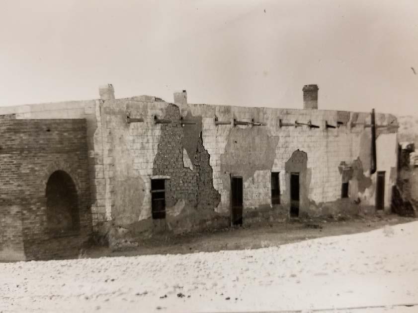
28 SECTION 2 Architectural Description: General Architectural Description: One-story stucco over frame and adobe building with two modern additions added to the East and West facades. The two additions encase the original structure, modifying the original shape and style of the building. The two additions have shed rooflines while the original has a side gable roof. A bird s eye photograph from 1954 shows the building at one time had a front porch around entrance. A brick wainscot is wrapped on the East and South façades and is a modern addition. The metal front door on the East façade is offset and flanked by two horizontally oriented vinyl windows. Modern, metal awnings have been placed over the doorway and windows. A rear metal door has been added to the original building on the South façade. Large swamp coolers have been placed on the shed roofs as well as ventilator caps. Additions, modifications, specify dates: Relocated, specify date, former location and information of interest: date unknown SECTION 3 Current National and State Register Status National Register Status: Individually Listed Not Individually Listed State Register Status: Individually Listed Not Individually Listed Included in a Listed Historic District: Contributing Non-Contributing Not Included National Register Evaluation: Individually Eligible Contributing Resource to a District Not Eligible/Non-Contributing Resource Applicable National Register (NR) Criteria: A Associated with events that have made a significant contribution to the broad pattern of our history B Associated with the lives of persons significant in our past C Embodies the distinctive characteristics of a type, period or method of construction or represents the work of a master, or possesses high artistic value, or represents a significant and distinguishable entity whose components lack individual distinctions D Has yielded, or is likely to yield, information important in prehistory or history Areas of Significance: Military, commerce Period(s) of Significance: and Level of Significance: National State Local Integrity: Location Design Materials Workmanship Feeling Association Setting Building Condition: Excellent Good Fair Deteriorated Is prior documentation available for this resource? Yes No Unknown Type: HABS Survey Other Documentation details: Include name and location Sanborn Fire Insurance Map, El Paso, Texas , Volume 2, page Plat of Fort Bliss by Captain Ruhlen. El Paso Community Foundation. of document, if known.


29 Survey Form Continuation Sheet 1932 West Paisano. South façade, camera facing north West Paisano. West facade, camera facing northwest.

30 1932 West Paisano. Northeast façade, camera facing southwest.

31 1932 W. Paisano 1954 aerial photo. Texas Department of Transportation photo 307.
32 1932 W. Paisano USGS Map Smeltertown ( 2018)

33 1893 Fort Bliss Plat by Captain Ruhlen 1932 W. Paisano
34 1928 Aerial Photograph courtesy IBWC (International Boundary and Water Commission) 1932 W. Paisano 1844 W. Paisano 1836 W. Paisano Hart House Hart s Mill
35 El Paso Sanborn Fire Insurance map, Volume 2, Page W. Paisano
36 2017 Aerial Photograph 1932 W. Paisano 1844 W. Paisano 1836 W. Paisano Hart House 2017 bird s eye photograph facing north (courtesy of Brian Kanof).

37 SURVEY AND EVALUATION OF OLD FORT BLISS AT HART S MILL EL PASO COUNTY State of Texas Historic Structures Survey Form SECTION 1 Identification: Current Name: Hart House Address: 1720 West Paisano Drive, El Paso, Texas Historic Name: Hart House, La Hacienda Restaurant Legal Address: Simeon Hart SURV 2 ABST #43 PT of SURV (3.15 AC) Owner Information: Name: Onate s Crossing LP Address: PO Box 1318 City: Santa Teresa State: NM Zip: Location: Geographic Location: Zone: 13 Easting: m Northing: m USGS Quad Name/Year: Smelter town/2018 Resource Description: Construction Date: 1851 Actual Estimated Source: 1971 NR nomination form Current Function: vacant apartments Historic Function: Officer quarters Current Use: Agriculture Commerce/Trade Defense Domestic Educational Government Healthcare Industry/Processing Recreation/Culture Religious Social Vacant Other: Historic Use: Agriculture Commerce/trade Defense Domestic Educational Government Healthcare Industry/Processing Recreation/Culture Religious Social Vacant Other: Image Information: Recorded by: Cherise Bell Date Recorded: 28 December West Paisano. Front facade, camera facing northwest.
38 SECTION 2 Architectural Description: General Architectural Description: One-story plastered, rectangular shaped, adobe house measures roughly 90 x58 with a non-historic 55 x18 addition on rear half of the south façade. The brick, arched porch measuring roughly 13 x 70 was added circa 1900 and has been enclosed at some point (date unknown). The flat roof is constructed of sycamore and willow. The curvilinear parapet was added after the 1936 HABS (Historic American Buildings Survey) but before 1947 based on a photo in the El Paso Morning Times newspaper, which is thought to have been printed on October 30, According to the HABS record the building had a central hall and eight or nine rooms. Additions, modifications, specify dates: Relocated, specify date, former location and information of interest: Ca porch, Ca curvilinear parapet SECTION 3 Current National and State Register Status National Register Status: Individually Listed Not Individually Listed State Register Status: Individually Listed Not Individually Listed Included in a Listed Historic District: Contributing Non-Contributing Not Included Name of District: Old Fort Bliss (at Hart s Mill) National Register Evaluation: Individually Eligible Contributing Resource to a District Not Eligible/Non-Contributing Resource Applicable National Register (NR) Criteria: A Associated with events that have made a significant contribution to the broad pattern of our history B Associated with the lives of persons significant in our past C Embodies the distinctive characteristics of a type, period or method of construction or represents the work of a master, or possesses high artistic value, or represents a significant and distinguishable entity whose components lack individual distinctions D Has yielded, or is likely to yield, information important in prehistory or history Areas of Significance: Military, commerce Period(s) of Significance: and Level of Significance: National State Local Integrity: Location Design Materials Workmanship Feeling Association Setting Building Condition: Excellent Good Fair Deteriorated Is prior documentation available for this resource? Yes No Unknown Type: HABS Survey Other Documentation details: Include name and location of document, if known National Register of Historic Places, Old Fort Bliss, El Paso County, Texas. Registered Texas Historic Landmark, Texas Historical Commission, Austin, Texas.


39 Survey Form Continuation Sheet 1720 West Paisano. Southeast façade, camera facing Northwest West Paisano. Rear facade, camera facing East.


40 1720 West Paisano, camera facing southwest. Painting ca showing Hart s Mill (left) and the Hart House next to it (El Paso Community Foundation)

41 1720 West Paisano. El Paso Public Library - Aultman Collection, no date West Paisano. El Paso Public Library - Aultman Collection, no date.

42 Hart s Mill to the left and the Hart House (1720 W. Paisano) to the right. Photograph from El Paso Community Foundation, no date W. Paisano. Photograph from El Paso Morning Times newspaper dated October 30, 1947?.
43 Hart House 1720 W. Paisano USGS Map Smeltertown ( 2018)


44 1853 Boundary Map Between the United States and Mexico by William Emory


45 1881 City of El Paso Engineer s Map Hart House, 1720 W. Paisano
46 1928 Aerial Photograph courtesy IBWC (International Boundary and Water Commission) 1844 W. Paisano 1836 W. Paisano Hart House, 1720 W. Paisano Hart s Mill
47 El Paso Sanborn Fire Insurance map, Volume 2, Page W. Paisano 1836 W. Paisano Hart House, 1720 W. Paisano
.")
48 2017 Aerial Photograph 1844 W. Paisano 1836 W. Paisano Hart House, 1720 W. Paisano 2017 bird s eye photograph facing north (courtesy of Brian Kanof).
Historic Cultural Properties Inventory (HCPI) Base Form (FORM 1)
 Base Form (FORM 1)") Historic Cultural Properties Inventory (HCPI) Base Form (FORM 1) Historic Preservation Division, New Mexico Office of Cultural Affairs For HPD Office use only: HCPI No. District No. NRHP: SRCP: Criteria:
Historic Cultural Properties Inventory (HCPI) Base Form (FORM 1) Historic Preservation Division, New Mexico Office of Cultural Affairs For HPD Office use only: HCPI No. District No. NRHP: SRCP: Criteria:
Current Functions (Enter categories from instructions) 02G04: Commerce/Trade - tavern 14D09: Transportation automotive service
 02G04: Commerce/Trade - tavern 14D09: Transportation automotive service") Site Inventory Form State Inventory No. 29-03500 New Supplemental State Historical Society of Iowa Part of a district with known boundaries (enter inventory no.) 29-03522 (November 2005) Relationship:
Site Inventory Form State Inventory No. 29-03500 New Supplemental State Historical Society of Iowa Part of a district with known boundaries (enter inventory no.) 29-03522 (November 2005) Relationship:
Current Functions (Enter categories from instructions) Materials (Enter categories from instructions)
 Materials (Enter categories from instructions)") Site Inventory Form State Inventory No. 92-00490 New Supplemental State Historical Society of Iowa Part of a district with known boundaries (enter inventory no.) 92-00349 (November 2005) Relationship:
Site Inventory Form State Inventory No. 92-00490 New Supplemental State Historical Society of Iowa Part of a district with known boundaries (enter inventory no.) 92-00349 (November 2005) Relationship:
Commonwealth of Massachusetts Massachusetts Historical Commission 220 Morrissey Boulevard, Boston, Massachusetts
 Inventory No: Historic Name: HRV.102 Shaker Tailor Shop Common Name: Address: 88 Shaker Rd City/Town: Village/Neighborhood: Harvard Shaker Village Local No: 5-22; 9; 93; 5-E Year Constructed: Architect(s):
National Register of Historic Places Registration Form
 United States Department of the Interior National Park Service National Register of Historic Places Registration Form This form is for use in nominating or requesting determinations for individual properties
COLORADO CULTURAL RESOURCE SURVEY Management Data Form Rev. 11/10
 COLORADO CULTURAL RESOURCE SURVEY OAHP1400 Rev. 11/10 A should be completed for each cultural resource recorded during an archaeological survey. Isolated finds and revisits are the exception and they do
City of Lockport Historic Resources Survey - Section METHODOLOGY
 2.0 METHODOLOGY Clinton Brown Company PN 07-008 2-1 April 2011 2.0 METHODOLOGY This methodology statement is prepared as part of the project tasks. It outlines the research sources identified, field strategies,
United States Department of the Interior National Park Service. State Historic Preservation Officer, Texas Historical Commission
 NPS Form 10-900 (Oct. 1990) OMB NO. 10024-0018 United States Department of the Interior National Park Service NATIONAL REGISTER OF HISTORIC PLACES REGISTRATION FORM 1. NAME OF PROPERTY HISTORIC NAME: Lindsay,
Commonwealth of Massachusetts Massachusetts Historical Commission 220 Morrissey Boulevard, Boston, Massachusetts
 Inventory No: Historic Name: HRV.2 Harvard Town Hall Common Name: Address: 13 Ayer Rd City/Town: Village/Neighborhood: Local No: Harvard Harvard Center 17D-05; 18; N2 Year Constructed: Architect(s): Architectural
Commonwealth of Massachusetts Massachusetts Historical Commission 220 Morrissey Boulevard, Boston, Massachusetts
 Inventory No: Historic Name: SDW.70 Hamblin, Thomas House Common Name: Address: 246 Rte 6A City/Town: Village/Neighborhood: Sandwich East Sandwich Local No: 67-050 Year Constructed: Architect(s): Architectural
Town of Taos Request for Proposal Historic Preservation GIS Geodatabase Project April 2007
 Town of Taos Request for Proposal Historic Preservation GIS Geodatabase Project April 2007 1. Background The Town of Taos is requesting proposals from qualified firms or a team of firms who can develop
Commonwealth of Massachusetts Massachusetts Historical Commission 220 Morrissey Boulevard, Boston, Massachusetts
 Inventory No: Historic Name: Common Name: Address: HRV.166 Hapgood, Shadrach House and Farm Lounger, Stephen N. - Roberts, Walter S. House 150 Ayer Rd City/Town: Village/Neighborhood: Local No: 8-43 Year
i TE:,Qi"if?inaI o 11 iirgs and uryden
 MAY 2 0 1980 i TE:,Qi"if?inaI o 11 iirgs and uryden ALTERATIONS- interior remodeling 1964 SIGWFICANCE a good southwestern example of Georgian Revival architecture in a planned academic setting AREA OF
/O/U / 013 om NO
 k s ~ i m (Rev. 886) 10900 l\l e L C S ~ /O/U / 013 om NO. 10240018 'Jnited States Department of the Interfor National Park Service NATIONAL REGISTER OF HISTORIC PIACES REGISTRATION FORM B=b 1. Name of
Commonwealth of Massachusetts Massachusetts Historical Commission 220 Morrissey Boulevard, Boston, Massachusetts
 Inventory No: Historic Name: HRV.60 Gale and Dickson Store Common Name: Address: 1 Still River Rd City/Town: Village/Neighborhood: Harvard Harvard Center Local No: 17D-02; 53; 31 Year Constructed: Architect(s):
Multiple Family Dwelling House; Single Family Dwelling House
 Inventory No: Historic Name: HRV.50 Patch House Common Name: Address: 20 Fairbank St City/Town: Village/Neighborhood: Center Local No: 17D-54; 262 Year Constructed: R 1750 Architect(s): Architectural Style(s):
THE HISTORY OF WEATHER OBSERVING IN CHEYENNE, WYOMING,
 THE HISTORY OF WEATHER OBSERVING IN CHEYENNE, WYOMING, 1870-2004 Downtown Cheyenne, Wyoming, circa 1890 From Wyoming State Archives, Department of State Parks and Cultural Resources Current as of January
BLOCK QUAD LOT DATE:_. PERIOD: ownf.r J u l i a Countryman THEME:
 COUNTY CITY BLOCK QUAD NAMP. C o u n t r y m a n H o u s e AnnBFss402 E. 9t.h 23-24 LOT _ rnnntvharris CITY: H O t i S t P n UTM: ARCHITECT/BUILDER:. DATE:_ 1907-08 PERIOD: ownf.r J u l i a Countryman
National Register of Historic Places Inventory Nomination Form. 1. Name '' ; 2. Location jf J M COMMERCIAL BUILDINGS IN STILLWATER
 NPS Form 10-900 (3-82) 0MB No. 1024-0018 Exp. 10-31-84 United States Department off the Interior National Park Service National Register of Historic Places Inventory Nomination Form See instructions in
Building Stones on the Dickinson College Campus Noel Potter, Geology (retired)
") Building Stones on the Dickinson College Campus Noel Potter, Geology (retired) Old West, designed by Benjamin Latrobe, designer of the Capitol in Washington, was built 1804 after a fire. The building,
Building Stones on the Dickinson College Campus Noel Potter, Geology (retired) Old West, designed by Benjamin Latrobe, designer of the Capitol in Washington, was built 1804 after a fire. The building,
OWNER: Mr> vt bwi"^ NHL ]RTHi7. roof: AtP.f^ DATE:-1:11:13 Al: LOT : NAME. COUNTY: CITY:_ ARCH ITECT/BU n npg] P.O.
![OWNER: Mr> vt bwi^ NHL ]RTHi7. roof: AtP.f^ DATE:-1:11:13 Al: LOT : NAME. COUNTY: CITY:_ ARCH ITECT/BU n npg] P.O.](/thumbs/93/114425611.jpg "OWNER: Mr> vt bwi^ NHL ]RTHi7. roof: AtP.f^ DATE:-1:11:13 Al: LOT : NAME. COUNTY: CITY:_ ARCH ITECT/BU n npg] P.O.") COUNTY BLOCK 6AS LOT : NAME COUNTY: CITY:_ PERIOD: -XLL ARCH ITECT/BU n npg] P.O. ei^-f^,r DATE:_ OWNER: Mr> vt bwi"^ THEME:_ STYLE: FYLf \;ic-hvi'ai/\ DESCRIPJION: 1- Sfhrxi P )
COUNTY BLOCK 6AS LOT : NAME COUNTY: CITY:_ PERIOD: -XLL ARCH ITECT/BU n npg] P.O. ei^-f^,r DATE:_ OWNER: Mr> vt bwi"^ THEME:_ STYLE: FYLf \;ic-hvi'ai/\ DESCRIPJION: 1- Sfhrxi P )
Vnited States D e w t. not for publication: N/A city/town: Waldron. in Arkansas of the Interior. National Park Service
 Vnited States D e w t National Park Service of the Interior WATfONAL REGISTER OF EtS!FORIC PLACES REGISTRATION FORM I, Name of Property - - - -. --- historic name: Poteau Work Center Residence #2 other
SHADOW STUDY REPORT REGARDING
 SHADOW STUDY REPORT REGARDING an APPLICATION TO REDEVELOP Three 6 Storey Condominiums Regional Road 25 (Ontario Street) and Britannia Road Milton, Ontario KNYMH FILE # 17030 Prepared by: Krista Lilley
Business Office; Multiple Family Dwelling House; Parsonage; Single Family Dwelling House
 Inventory No: Historic Name: HRV.28 Unitarian Church Parsonage Common Name: Address: 5 Littleton Rd City/Town: Village/Neighborhood: Center Local No: 17D-16; 233 Year Constructed: C 1850 Architect(s):
APPENDIX 1 LITTLE EGYPT FROM THE AIR
 APPENDIX 1 LITTLE EGYPT FROM THE AIR FIGURE 1. In this 1930 City of Dallas aerial photo, the land surrounding Little Egypt is seen as cultivated fields and agricultural structures. The Hill property is
Brockschmidt-Miller House Spires, Timothy, House; #359
 NPSFOTH ; C-900 (Rev. 8-8S1 United States Department of the Interior National Park Sen/ice National Register of Historic Places Registration Form FEB 1 6 1990 OMB No. 1024-0018 NATIONAL This form is for
BLOCK QUAD LOT. _ ritv- H o u s t o n UTM:. STYLE:.
 COUNTY CITY NAME ADDRESS: 1421 Harvard ftpruitrrt/riinnfrwm. rtu-mitp. H a r o l d R. 157 BLOCK QUAD A. W i l s o n - b u i l d e r Elsom LOT _ COUNTY:^ H a r r i s _ ritv- H o u s t o n UTM:. natf1905
National Register of Historic Piaces Registration Form
 NPS FoTn '.C-SOO (Rev. 8-86) United States Department of the Interior National Park Sen/ice National Register of Historic Piaces Registration Form NATIONAL REGISTER OMB Na 1024-001S This form is for use
C1.0 HOP IN FUEL STATION BENCHMARKS PARKING SUMMARY TABLE SITE PAVING: NOTES: SITE LOCATION MAP LEGEND DESCRIPTION PROPOSED EXISTING
 LOCATION MAP UNIVERSAL CITY GUADALUPE SITE CITY OF SCHERTZ NOTES: CONVENIENCE STORE 4500 S.F. PARKING SUMMARY TABLE SITE PAVING: CARWASH 1075 S.F. BENCHMARKS EXISTING PROPOSED LEGEND DESCRIPTION REVISIONS:
United States Department of the Interior National Park Service National Register of Historic Places Registration Form.
 NPS Fo-m -.C-SOO tr«. S-8«> United States Department of the Interior National Park Service National Register of Historic Places Registration Form 4SJ OMBNa 1024-001S FEB 1 e )gnj This form is tor use in
NATIONAL REGISTER OF HISTORIC PLACES REGISTRATION FORM NATIONAL
 /3 NPS Form 10-900 (Rev. 8-86) United States Department of the National Park Service Interior OMB No. 1024-0018 p r [] \^! ^ NATIONAL REGISTER OF HISTORIC PLACES REGISTRATION FORM NATIONAL 1. Name of Property
PONDEROSA. June 4, Troy Fujimoto Senior Planner City of Pleasant Hill 100 Gregory Lane Pleasant Hill, CA
 Attachment B PONDEROSA June 4, 2018 Troy Fujimoto Senior Planner City of Pleasant Hill 100 Gregory Lane Pleasant Hill, CA 94523. H 0 M ES Re: Reliez Terrace ARC Study Session Submittal Dear Troy, Ponderosa
STYLE: THEME: s l i g h t l y arched doorway on second l e v e l i s main entrance^ w i t h.ggtiarpri (rnni-. BUILDING MATERIAL: wau:
 COUNTY CITY MAD MAMF-Tmmanuel L u t h e r a n Church AnnpF«;
S a c r a m e n t o S t r e e t, S a n F r a n c i s c o. M a l i n G i d d i n g s & M a x A r m o u r
 PAC I F I C H E I G H T S H i s t o r i c Q u e e n A n n e M a n s i o n 2 2 2 0 S a c r a m e n t o S t r e e t, S a n F r a n c i s c o P r e s e n t e d b y : M a l i n G i d d i n g s & M a x A r
0 buildings public-state. sites public-federal _ structure structures. 1 ~ir~ Total
 NPSFoTn : C -900 lr«v. 8-a
ORDINANCE NO
 ORDINANCE NO. 174421 VAN NUYS CENTRAL BUSINESS DISTRICT COMMUNITY DESIGN OVERLAY PERMANENT [Q] CONDITIONS ORDINANCE An ordinance AMENDING Section 12.04 of the Los Angeles Municipal Code by amending the
PW Parkway ES Prince William County, Virginia WSSI #
 PW Parkway ES Prince William County, Virginia WSSI #15.3 Cultural Resources Site Assessment November 15 Prepared for: Prince William County Public Schools P.O. Box 39 Manassas, Virginia 1 Prepared by:
Commonwealth of Massachusetts Massachusetts Historical Commission 220 Morrissey Boulevard, Boston, Massachusetts
 Inventory No: Historic Name: Common Name: Address: SBR238 Smith, Capt Isaac House Newton, Sullivan Ball House 69 Turnpike Rd City/Town: Village/Neighborhood: Southborough Fayville Local No: 38-66 Year
FEB 1 6 LJ. National Register of Historic Places Registration Form. United States Department of the Interior National Parl< Service
 NPS Foin C-900 (R». 6-661 United States Department of the Interior National Parl< Service National Register of Historic Places Registration Form FEB 1 6 LJ OMB No. 1034-0018 NATfOMAL REGISTER This form
LOT _ COUNTY: _ UTM: PERIOD; STYLE: 530 Harvard Houston. TX 77007
 COUNTY 289 19 BLOCK QUAD NAME:. ADDRFSS- 530 Harvard ARCHITErT/BIin.nF.R:prnh;qhly J o g OWNER: R o s e n d o R u p n t p l l n LOT _ COUNTY: Harris _ ritvhouston _ UTM: n g l p - b l d r P A T F : _ 19Q6-Q7
Sales Date Grantor Convey No. Convey Typ # Parcels Sales Price
 Owner Name FINDLEY FRANK A Prop. Class Land Use C - Commercial 471 - DWELLING CONVERTED TO Site Address LegalDescriptions 2584 BRIGGS RD 2584 BRIGGS RD LOT 89 BLK 2 EUREKA PARK Tax District Sch. District
D U P L E X D E S I G N G U I D E L I N E S
 PURPOSE As The City Beautiful, Orlando s vision is defined by a focus on its amenities. One of the key elements of that vision is strong urban design. Attention to building design encourages an aesthetically
The Highland - List of materials needed to construct a weather tight home.
 Page:1 The Highland - List of materials needed to construct a weather tight home. PLEASE NOTE: 1. 'While every attempt has been made in the preparation of this materals list to avoid mistakes, B&H Cedar
TOWN OF SEVERANCE, COLORADO. NOTICE OF PUBLIC HEARINGS FOR A PROJECT Hunters Crossing Annexation & Zoning
 TOWN OF SEVERANCE, COLORADO NOTICE OF PUBLIC HEARINGS FOR A PROJECT Hunters Crossing Annexation & Zoning NOTICE IS HEREBY GIVEN that the Public Hearing required by C.R.S. 31-12-108 before the Severance
A^^mm. ADDRESS: 1846 Harvard
 COUNTY CITY Q"^P Woman's C l u b 105 BLOCK 25 LOT ADDRESS: 1846 Harvard COUNTY:. H a r r i s ritv- H o u s t o n UTM: ARCHITECT/BUILDER: nu-mfb-hnnston H e i g h t s W o m a n ' s n n h IPAfi u^r-^r^rd
S. 24. (1910 #22), #21-20), #19) - #12-13), #14), #15) (BPL
, #21-20), #19) - #12-13), #14), #15) (BPL") Figure 24. Postcard view of actual Chittenden and Eastman buildings on S. 3 rd Street (1910 postmark), looking north left: office (Map #22), factory buildings (Map #21-20), and older small building (site
Figure 24. Postcard view of actual Chittenden and Eastman buildings on S. 3 rd Street (1910 postmark), looking north left: office (Map #22), factory buildings (Map #21-20), and older small building (site
A Unique Building For the Discerning Client P O S T ROA D E A S T W E S T P O R T, C O N N E C T I C U T
 A Unique Building For the Discerning Client 1 0 3 2 P O S T ROA D E A S T W E S T P O R T, C O N N E C T I C U T 1032 Post Road East Westport represents a unique opportunity to acquire or lease a brand
COULD THE GUNSHOT BE HEARD?
 COULD THE GUNSHOT BE HEARD? October 9, 2003 Paul D. Schomer Schomer & Associates Champaign, IL 61821 INTRODUCTION Statement of Problem On the evening of November 21, 1991, a NJ State Trooper gave chase
National Register of Historic Places Registration Form
 United States Department of the Interior National Park Service National Register of Historic Places Registration Form This form is for use in nominating or requesting determinations for individual properties
OUR TEAM SHEET INDEX CIVIL C O V E R S H E E T. T H E C O V E A T P A C I F I C A S A N J U A N S a n J u a n C a p i s t r a n o, C A
 OUR TEAM SHEET INDEX OWNER/DEVELOPER: PACIFIC POINT DEVELOPMEN PARTNERS LLC CONTACT: MATTHEW LAND 100 SPECTRUM CENTER DR, SUITE 1450 BUSINESS: (949) 341-1237 IRVINE, CA 92618 ARCHITECT / PLANNER: BASSENIAN
conceptdesigns C0NCEPTDESIGNSARCHITETURE.CO.NZ architecture S t a g e Gisborne Beach House
 C0NCEPTDESIGNSARCHITETURE.CO.NZ conceptdesigns architecture S t a g e 2 A Gisborne Beach House GISBORNE BEACH BRIEF HOUSE conceptdesigns architecture Beth and Chris want to design and build their forever
OUR TEAM SHEET INDEX CIVIL C O V E R S H E E T. T H E C O V E A T P A C I F I C A S A N J U A N S a n J u a n C a p i s t r a n o, C A
 OUR TEAM SHEET INDEX OWNER/DEVELOPER: PACIFIC POINT DEVELOPMEN PARTNERS LLC CONTACT: MATTHEW LAND 100 SPECTRUM CENTER DR, SUITE 1450 BUSINESS: (949) 341-1237 IRVINE, CA 92618 ARCHITECT / PLANNER: BASSENIAN
ARCHITECTURE IN THE DAYLIGHT
 ARCHITECTURE IN THE DAYLIGHT Site Location MANUS LEUNG HARVARD GSD FALL 2015 The house is located in Jl. Intern Corn Kebun Jeruk Blok U3 No.18, Kembangan District of Jakarta 11640 Indonesia. 01 OBJECTIVES
A Note on the astronomical inspiration for Burchfield s Orion and the Moon
 A Note on the astronomical inspiration for Burchfield s Orion and the Moon Long ago I published an article on astronomy in the works of Burchfield (Harrington 1990), in which I speculated on the date that
SHADE/SHADOW REPORT. For the Proposed 8777 Washington Project. Culver City, CA. Prepared for:
 SHADE/SHADOW REPORT For the Proposed 8777 Washington Project Culver City, CA Prepared for: VITRUVIAN CULVER CITY LLC (THE APPLICANT) 5822 WEST WASHINGTON BOULEVARD CULVER CITY, CALIFORNIA 90232 Prepared
EXHIBIT H LOT 317 GRADING AND SITE PLAN
 EXHIBIT H LOT 317 GRADING AND SITE PLAN EXHIBIT I LOT 317 ELEVATIONS ridge height 4915'-6" GENERAL & KEYED NOTES ridge height 4905'-9" 3 7 4 A5.1 1 5 ridge height 4910'-6" 2 ridge height 4906'-3" 1 Provide
Sales Date Grantor Convey No. Convey Typ # Parcels Sales Price
 Owner Name LOHR DONNA L LOHR DONNA L Prop. Class Land Use R - Residential 550 - CONDOMINIUM UNIT Site Address LegalDescriptions 4714 MERRIFIELD PL BRANFORD VILLAGE CONDOMINIUM BLDG 15 UNIT 70 Tax District
Images: Figure 4. Burlington in 1873, with historic district outlined (Andreas 1873). 52
. 52") Images: Figure 4. Burlington in 1873, with historic district outlined (Andreas 1873). 52 Figure 5. Building constructed in 1876 at 100-104 S. 3 rd Street (Map #12) (Pollock, Granger & Chittenden 1881:
Images: Figure 4. Burlington in 1873, with historic district outlined (Andreas 1873). 52 Figure 5. Building constructed in 1876 at 100-104 S. 3 rd Street (Map #12) (Pollock, Granger & Chittenden 1881:
Energy Use in Homes 2007
 Energy Use in Homes 2007 A series of reports on domestic energy use in England Space and Water Heating Energy Use in Homes 2007 A series of reports on domestic energy use in England This is one of a series
Sacred Lands File & Native American Contacts List Request
 Sacred Lands File & Native American Contacts List Request NATIVE AMERICAN HERITAGE COMMISSION 915 Capitol Mall, RM 364 Sacramento, CA 95814 (916) 653-4082 (916) 657-5390 Fax nahc@pacbell.net Information
12300 SWANHAVEN DR, OK 73170, OKLAHOMA CITY, OK
 300 SWANHAVEN DR, OK 73170, OKLAHOMA CITY, OK 73170 942 Property Address 300 SWANHAVEN DR, OK 73170 OKLAHOMA CITY, OK 73170 Latitude: 40.00001 Longitude: -90.00001 Details Claim Number: RAM-5623448 Requested:
Preliminary Damage Report of the August 22, 2011 Mw 5.3 Earthquake near Trinidad, Colorado
 Preliminary Damage Report of the August 22, 2011 Mw 5.3 Earthquake near Trinidad, Colorado Matthew L. Morgan and Karen S. Morgan Colorado Geological Survey At 11:46 PM MDT on August 22, 2011, a Mw 5.3
Number of Resources within Property buildings
 NPS Foin. C -900 tnn. 6-66) United States Department of the Interior National Park Sen/ice National Register of Historic Places Registration Form i FEB 1 6 --J NATIONAL OMB No. 1024-0018 This form is for
8 th 12 th Designing a Monitoring Plan Mapping & Analysis (Activities 1 2)
") 8 th 12 th Designing a Monitoring Plan Mapping & Analysis (Activities 1 2) Objectives for All Activities - To be able to define and describe the purpose and uses of topographic maps. - To define rules
8 th 12 th Designing a Monitoring Plan Mapping & Analysis (Activities 1 2) Objectives for All Activities - To be able to define and describe the purpose and uses of topographic maps. - To define rules
Shell-keeps - The Catalogue
 Fig. 1. Arundel Castle. The shell-keep, well tower and forebuilding from the south-east (lower bailey). The original Norman door is half-hidden by the later forebuilding. 1. Arundel The shell-keep, with
September 28, 2004 Parkfield Earthquake
 PRELIMINARY REPORT ON SEPTEMBER 28, 2004 PARKFIELD EARTHQUAKE By Rakesh K. Goel, M.EERI and Charles B. Chadwell, M. EERI Department of Civil & Environmental Engineering, California Polytechnic State University,
UPTON ROAD CLAUGHTON CH43 9RN
 UPTON ROAD CLAUGHTON CH43 9RN 359 Woodchurch Road, Birkenhead, Merseyside, CH42 8PE E-mail: prenton@clivewatkin.com Tel: 0151 608 8589 Hamilton Memorial UR Church, Upton Road, Claughton A special opportunity
UTILITY REPORT FOR THORNTON SELF STORAGE THORNTON, COLORADO
 UTILITY REPORT FOR THORNTON SELF STORAGE THORNTON, COLORADO Prepared by: Bowman Consulting 63 Park Point Dr. Suite 1 Golden, CO 841 (33)-81-29 June 29, 215 Revised August 14, 215 Revised September 3, 215
BLOCK QUAD LOT _ COUNTY:. DATE:
 COUNTY CITY NAME. ADDRESS: 301-303 E. 15th LOT _ COUNTY:. Harris _ ritv: Houston _ ARCHITECT/BUILDER: JJ8. p t. 13-14 BLOCK QUAD UTM: DATE:_ STYLE:. THEME: 1 904 PERIOD :- QU'Mirp.Macaria D. Sanchez 301
DESIGN AWARD OF EXCELLENCE C H U L A V I S T A CHS SITE THE END GUSD C H R I S T O P H E R H I G H S C H O O L
 2011 C.A.S.H. / CCAIA LEROY F. GREENE DESIGN AWARD OF EXCELLENCE C H U L A V I S T A CHS SITE THE END GUSD C H R I S T O P H E R H I G H S C H O O L BUILDINGS Arts Science/Agriculture Gymnasium Cafeteria/Library
55a. G 6042, pair statuette, and (MFA C 11117) 55b. G 6052, fragment of limestone relief, text {5.18} (MFA B 5816) xviii
 55b. G 6052, fragment of limestone relief, text {5.18} (MFA B 5816) xviii") List of Plates Color plate 1a. View of Cemetery G 6000 (center), looking west from the top of the Great Pyramid (Nov. 16, 1993). Photograph by Peter Der Manuelian Color plate 1b. View of Cemetery G 6000
List of Plates Color plate 1a. View of Cemetery G 6000 (center), looking west from the top of the Great Pyramid (Nov. 16, 1993). Photograph by Peter Der Manuelian Color plate 1b. View of Cemetery G 6000
Agricultural; Dairy; Single Family Dwelling House. Roof: Asphalt Shingle Wall: Wood Clapboard; Wood Foundation: Concrete Unspecified; Stone, Uncut
 Inventory No: Historic Name: Common Name: Address: SBR.82 Flagg, Elisha House Simpson, Erastus B. - Harlow, George C. House 123 Middle Rd City/Town: Southborough Village/Neighborhood: Local No: 36-022
GIS and Predictive Modeling: Identifying North Carolina s Historic Archaeological Resources
 Environmental Services, Inc. GAI Consultants, Inc. GIS and Predictive Modeling: Identifying North Carolina s Historic Archaeological Resources Ben Resnick (GAI) and Scott Seibel (ESI) Historic Archaeological
APPROVED JURISDICTIONAL DETERMINATION FORM U.S. Army Corps of Engineers
 APPROVED JURISDICTIONAL DETERMINATION FORM U.S. Army Corps of Engineers This form should be completed by following the instructions provided in Section IV of the JD Form Instructional Guidebook. SECTION
APPROVED JURISDICTIONAL DETERMINATION FORM U.S. Army Corps of Engineers
 APPROVED JURISDICTIONAL DETERMINATION FORM U.S. Army Corps of Engineers This form should be completed by following the instructions provided in Section IV of the JD Form Instructional Guidebook. SECTION
Sign Code Amendment: Illustrated Definitions. Prepared for the Monday, May 15, 2017 Planning Commission Work Session Meeting
 Sign Code Amendment: Illustrated Definitions Prepared for the Monday, May 15, 2017 Planning Commission Work Session Meeting SIGN Any o letter, o word or symbol, o poster, o picture, o reading matter, or
BLOCK LOT DATE:_. PERIOD:. OWNER- Wilson D. Mabry, J r.
 COUNTY QUAD CITY NAME: E l k i n s House BLOCK LOT _ AnnRF.ss- (^n? F. Qth COUNTY CITY: UTM Harris Hmi.st.on ARCHITECT/BUILDER: DATE:_ PERIOD:. OWNER- Wilson D. Mabry, J r. STYLE: 2022 De M i l o H o u
Uniform Sign Plan (USP) Travis Park 89-USP-007
 Travis Park 89-USP-007") Uniform Sign Plan (USP) Travis Park 89-USP-007 These guidelines are published for informational purposes. A sign permit application must be submitted and a permit issued prior to installation of a sign.
Uniform Sign Plan (USP) Travis Park 89-USP-007 These guidelines are published for informational purposes. A sign permit application must be submitted and a permit issued prior to installation of a sign.
Simple Solutions Social Studies Level 2. Level 2. Social Studies. Help Pages
 Level 2 Social Studies 147 148 adobe houses with bricks made of clay and straw ancestor a family member who lived before us appoint choose; leaders can appoint others barter trading one thing for another
NCEES FS Practice Exam
 NCEES FS Practice Exam Terrametra Resources Lynn Patten 1. One corner of a 60-ft. 120-ft. lot, otherwise rectangular, is a curve with a radius of 20 ft. and a central angle of 90. The area (ft. 2 ) of
A Survey on Changing Socio-Spatial Pattern in Contemporary Housing of Iran
 A Survey on Changing Socio-Spatial Pattern in Contemporary Housing of Samira Forouzmand Assoc. Prof. Dr. Hifsiye Pulhan Defense of thesis, January 2013 Eastern Mediterranean University Department of Architecture
Trip Generation Study: A 7-Eleven Gas Station with a Convenience Store Land Use Code: 945
 Trip Generation Study: A 7-Eleven Gas Station with a Convenience Store Land Use Code: 945 Introduction The Brigham Young University Institute of Transportation Engineers student chapter (BYU ITE) completed
Tornadoes. Tornadoes. When do tornadoes occur? Tornado Alley
 Tornadoes Tornadoes Dr. Christopher M. Godfrey University of North Carolina at Asheville Photo: D. Zaras, NOAA A tornado is a violently rotating column of air in contact with the ground Tornadogenesis
Tornado Damage in Happy, Texas, May 5, 2002
 Tornado Damage in Happy, Texas, May 5, 2002 A report prepared by Larry J. Tanner, P.E. Submitted to NIST August 19, 2002 Wind Science and Engineering Research Center Texas Tech University Lubbock, Texas
4. Find the areas contained in the shapes. 7. Find the areas contained in the shapes.
 Geometry Name: Composite Area I Worksheet Period: Date: 4. Find the areas contained in the shapes. 7. Find the areas contained in the shapes. 4 mm 2 mm 2 mm 4 cm 3 cm 6 cm 4 cm 7 cm 9. Find the shaded
CONGLETON INDUSTRIAL PARK LT 6 EX W 300' & E 350' LT 7 BLK 1, a subdivision of land in the City of Overland Park, Johnson County, Kansas.
 NOTICE OF PUBLIC HEARING CITY PLANNING COMMISSION CITY OF OVERLAND PARK, KANSAS Notice is hereby given that the City Planning Commission of Overland Park, Kansas, will hold a public hearing Monday, July
Tornadoes. Tornadoes. When do tornadoes occur? Tornado Alley
 Tornadoes Tornadoes Dr. Christopher M. Godfrey University of North Carolina at Asheville Photo: D. Zaras, NOAA A tornado is a violently rotating column of air in contact with the ground Tornadogenesis
APPROVED JURISDICTIONAL DETERMINATION FORM U.S. Army Corps of Engineers
 APPROVED JURISDICTIONAL DETERMINATION FORM U.S. Army Corps of Engineers This form should be completed by following the instructions provided in Section IV of the JD Form Instructional Guidebook. SECTION
VIKING INSPECTION PROPERTY 4921 U.S. Hwy. 85, Williston, ND 58801
 SALE PRICE: $799,000 LOT SIZE: +/-2.49 Acres BUILDING SIZE: +/-3,800 SF DRIVE-IN DOORS 2 CEILING HEIGHT: 16' YEAR BUILT: 2007 ZONING: Commercial PROPERTY OVERVIEW Highly visible, hard-to-find small shop/office/apartment
Ownership of Property Category of Property Number of Resources within Property X private X building(s) Contributing Noncontributing
 Contributing Noncontributing") NPS FoTn -0-900 (Rev. 8-86) United States Department of the Interior National Park Service National Register of Historic Places Registration Form V60 FEB 1 6 19^3 OMB Na 1024-0018 NATiONAL REGISTER This
NPS FoTn -0-900 (Rev. 8-86) United States Department of the Interior National Park Service National Register of Historic Places Registration Form V60 FEB 1 6 19^3 OMB Na 1024-0018 NATiONAL REGISTER This
Anthropology 1030: Introduction to Archaeology. Mapping and Taphonomy
 Anthropology 1030: Introduction to Archaeology Project Based Research Assignments #2 Mapping and Taphonomy Author: Steven Gregerson 6/20/2011-6/20/102011 Date: 6/20/2011 Site Location: Living Room at house
December 13, Kirk Shields Green Mountain Power 163 Acorn Lane Colchester, VT 05446
 December 13, 2017 Kirk Shields Green Mountain Power 163 Acorn Lane Colchester, VT 05446 RE: End of Field Letter for Archaeological Phase II Site Evaluation at Site VT-CH-1218 within the Proposed Milton
Earthquake Risk in Canada and the National Building Code
 Earthquake Risk in Canada and the National Building Code Tuna Onur, Ph.D. Onur Seemann Consulting, Inc. NICC, Vancouver, BC, 28-30 September 2016 Southwestern Canada: Cascadia Subduction Zone + Crustal
Appendix C Surface Water and Groundwater Interaction Memorandum
 Texas Custodial Trust 2301 West Paisano Drive El Paso, Texas 79922 Appendix C Surface Water and Groundwater Interaction Memorandum 6835001 Malcolm Pirnie, Inc. 410 N. 44 th Street, Suite 1000 Phoenix,
MAY National Register of Historic Places Registration Form. United States Department of thie interior National Park Service
 NPS FoTTi '.C-9CX} IPm. 6-66) United States Department of thie interior National Park Service National Register of Historic Places Registration Form OMBNa. 10040016 r \ LlLl,,«v n C 1QQ1 ' MAY 0 6 1991
schematic lighting design courtesy of william rawn associates
 WHEELOCK COLLEGE CAMPUS CENTER AND STUDENT RESIDENCE schematic lighting design courtesy of william rawn associates anne k cheney lighting g electrical option advisor : dr. kevin houser b u i l d i n g
Gravestones for Hugh and Bathsheba Canedy. Gate to Christian Hill Cemetery. Colrain Township Franklin County, Massachusetts
 Gravestones for Hugh and Bathsheba Canedy Christian Hill Cemetery Colrain Township Franklin County, Massachusetts Photos: Loren Caneday, October 2004 Both photos look westward Gate to Christian Hill Cemetery