BLOCK QUAD LOT DATE:_. PERIOD: ownf.r J u l i a Countryman THEME:
|
|
|
- Elfrieda Jennings
- 5 years ago
- Views:
Transcription

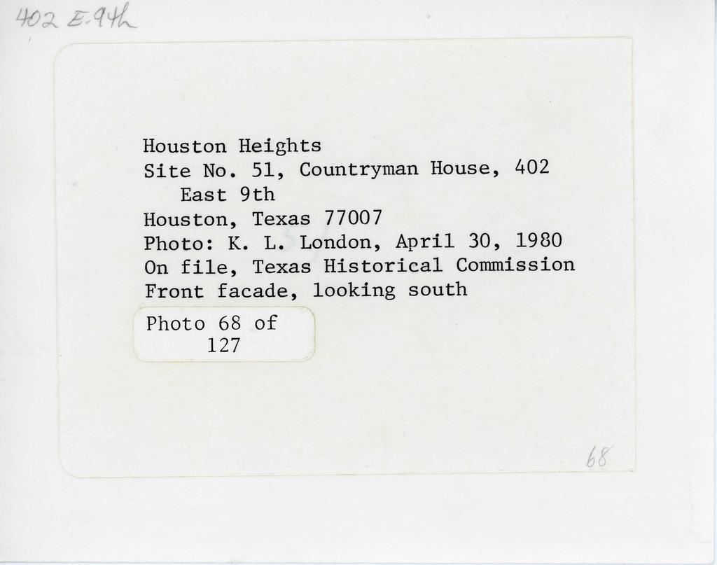
1 COUNTY CITY BLOCK QUAD NAMP. C o u n t r y m a n H o u s e AnnBFss402 E. 9t.h LOT _ rnnntvharris CITY: H O t i S t P n UTM: ARCHITECT/BUILDER:. DATE:_ PERIOD: ownf.r J u l i a Countryman STYLE:. 407 F. Qt-.l-i Hou.qtnn^ THEME: 770QB DESCRIPTION:Raised c o t t a g e, framc?^ l - s t o r y, p i t c h r o o f w i t h p r o i e c l - i n a gable end bay (window i n g a b l e ), a t t a c h e d p o r c h s u p p o r t e d by n n r i r colnmn.s, square b a l u s t e r s, s i n g l e f r o n t door w i t h transom, windows 1/1, l a t t i c e and b r i c k p i e r s under house. BUILDING MATERIAL: wall: PHYSICAL ronnition- g o o d - s i g n i f i c a n t ALTERATIONS: roof:. SITE: original.or movccl.date. sir.nificanrf-excellent example o f w e l l - k e p t t y p e o f r a i s e d c o t t a g e i n H e i g h t s. The r a i s e d c o t t a g e was n o t p a r t i c u l a r l y common t o t h e neighborhood. The house was b u i l t f o r Ran.qnm V i c k ^ b u t has been o c c u p i e d by t h e Countryman AREA OF SIGNIFICANCE: LEVEL OF SIGNIFICANCE: DESIGNATION: NR NHL RTHL HABS HAER HESI HSI OTHER: ORIGINAL IISF- r p. q j rip>nf-»:> PRESENT USE: T - P ^ i ripnr^ta RELATIONSHIP TO s i i R R O T i N n i N r. s - c h a i n - l i n k f e n c e a r o u n d w e l l - k e p t ACREAGE/BOUNDARY DESCRIPTION: : BIBLIOGRAPHIC DATA: SEE INFO/CORRESPONDENCE FILES:. RECORDED BY: KLL DATE:_ 4/30/80 INFORMANT:PHOTO DATA: ( COnt ) corner l-35mm (rev. 6-79) lot with ( COnt )
2 MPS Form «(M2) United States Department of the Interior National Park Service National Register off Historic Places Inventory Nomination Form OMB No Exp Continuation sheet Item number 4, 7, 8, 10 Page 51 Site No. 51 NAME Countryman House COUNTY Harris BLOCK 250 ADDRESS 402 Ea^9th CITY_ Houston "LOT UTM ~ Zone 15 E N ARCHITECT/BUILDER unknown DATE_ PERIOD 1900 Olv'NER Julia Countryman STYLE_ Queen Anne influence 402 East 9th, Houston. Texas THEME" DESCRIPTION One-story raised frame cottage; pitched roof with projecting front gable end bay (window in gable); attached porch supported by Doric columns, square balusters, single front door with transom; windows with one-over-one lights; extremely high brick piers under house with latticework between. Building material: wall frame/clapboard roof composition Physical condition good-significant site original X or moved date Alterations metal window frames SIGNIFICANCE Fine example of well-kept raised cottages of the Heights. The raised cottage is not particularly common in the neighborhood. The house was built for Ransom Vick, but has been occupied by the Countryman family since about Area of significance^ architecture Level of significance local DESIGNATION: NR NHL RTHL HABS HAERniEST HSI OTHER ORIGINAL USE residence PRESENT USE_ residence RELATIONSHIP TO SURROUNDINGS Chain-link fence around well-kept corner lot with large trees; residential neighborhood. ACREAGE/BOUNDARY DESCRIPTION less than one acre BIBLIOGRAPHY RECORDED BY K. L. London INFORMANT DATE April PHOTO DATA i - 35 mm.. Tex. Hist. Commission
3 NPS Fom OMB No r^szi Exp United States Department of the Interior National Park Service National Register off Historic Places inventory Nomination Form For HPS use only date entered Ckxitinuatlon sheet Item numtier Page Multiple Resource Area. Thematic Group dnr-ll Name State Houston Heights Multiple Resource Area Texas Nomination/Type of Review Date/Signature 1. All Saints Roman Catholic Chijf^<^j.^y-^; U "j^eepev 0^-*'^'^''*-'-^^'-/^^*^^ ^A^- National R««ieter 2. Allbach House Bubstantive Kev.ow Keeper.A.ccf<frCxc'^-^:^A/^/i^ 1^ 3. Banta House lotap^d In tko f^eepev.^^tj^^^^^^^-w^^^y^^ d A ^A National Register ' ^^^^^ ^ ' 4. Borgstrom House Stlo^^e^ter -^eper (yjum^^u^^v^-j^ ^A*'^/^' 5. Building at 430 Harvard Street Hational R«c*«t«r eeper 6. Burge House Entered in tlie A'K^eper.Or^A--L.-<_^/^y<.^ ^A National ReglBtef 7. Burnett House UUh/OWNER OBJECTION 8. Cole, Judge Robert L., House ' Qt/O-AAA. CBJECTIQN ' DeterroTneJ TnTp'^^T, 9. Coop, Dr. B. F., House f/^^^^^'seg^rter. deeper,<7(lul^^fi^y<^ ^A'^/^'^ 10. Countryman House Entered In the ^eeper "V^J Hational Register

4 NATIONAL REGISTER OF HISTORIC PLACES fvaujatlon / RETURN SHE UMM ttatm NatieiMl Part SenriM Cocntrynnan House (Houston Heights MRA) Harris.County TEXAS ^ ^, MAY Working No. Date Qua- ^/f/h^ - c-/^?// Action: Z^ACCEPT^^^^^ resubmission Entered in the RETURN nomination by person or local govsrnmsnt Rational Re«iBter ^ REJECT owner objection Federel Agency: appsal Substantivs Rsvisw: _sempls..request h_ eppssl ^^NR decision Reviewer's commsnts: Recom. /Criteria Reviewer Oiscipiins Date. coetinustion shset Nomination returned for: technicsl corrsctions citsd below _substantive ressons discussed below 1. Name 2. Location 3. Classification 4. Owner of Property 5. Location of Legal Description 6. Pepresentation in Existing Surveys 7. Description summsry psrsgrsph compietsness cisrity sitsrstions/intsgrity dstes

5 8. Significance summery psrsgrsph completeness cisrity Sppiicabie criteria justification of areas checked relating significance to the resource context relationship of integrity to significance justification of exception other 9. Major Bibiiograpiiical References 10. Oeographical Data UMTI 11. Form Prepared By 12. State Historic Preservation Officer Certification 13. Other Maps Photographs Other Questions concerning this nomination may be directed to Signed Date Phone: Comments for any Item msy bs continued on sn sttsched sheet

6
7
8 Please refer to the map in the Multiple Property Cover Sheet for this property Multiple Property Cover Sheet Reference Number:
LOT _ COUNTY: _ UTM: PERIOD; STYLE: 530 Harvard Houston. TX 77007
 COUNTY 289 19 BLOCK QUAD NAME:. ADDRFSS- 530 Harvard ARCHITErT/BIin.nF.R:prnh;qhly J o g OWNER: R o s e n d o R u p n t p l l n LOT _ COUNTY: Harris _ ritvhouston _ UTM: n g l p - b l d r P A T F : _ 19Q6-Q7
BLOCK QUAD LOT. _ ritv- H o u s t o n UTM:. STYLE:.
 COUNTY CITY NAME ADDRESS: 1421 Harvard ftpruitrrt/riinnfrwm. rtu-mitp. H a r o l d R. 157 BLOCK QUAD A. W i l s o n - b u i l d e r Elsom LOT _ COUNTY:^ H a r r i s _ ritv- H o u s t o n UTM:. natf1905
A^^mm. ADDRESS: 1846 Harvard
 COUNTY CITY Q"^P Woman's C l u b 105 BLOCK 25 LOT ADDRESS: 1846 Harvard COUNTY:. H a r r i s ritv- H o u s t o n UTM: ARCHITECT/BUILDER: nu-mfb-hnnston H e i g h t s W o m a n ' s n n h IPAfi u^r-^r^rd
BLOCK LOT DATE:_. PERIOD:. OWNER- Wilson D. Mabry, J r.
 COUNTY QUAD CITY NAME: E l k i n s House BLOCK LOT _ AnnRF.ss- (^n? F. Qth COUNTY CITY: UTM Harris Hmi.st.on ARCHITECT/BUILDER: DATE:_ PERIOD:. OWNER- Wilson D. Mabry, J r. STYLE: 2022 De M i l o H o u
STYLE: THEME: s l i g h t l y arched doorway on second l e v e l i s main entrance^ w i t h.ggtiarpri (rnni-. BUILDING MATERIAL: wau:
 COUNTY CITY MAD MAMF-Tmmanuel L u t h e r a n Church AnnpF«;
BLOCK QUAD LOT _ COUNTY:. DATE:
 COUNTY CITY NAME. ADDRESS: 301-303 E. 15th LOT _ COUNTY:. Harris _ ritv: Houston _ ARCHITECT/BUILDER: JJ8. p t. 13-14 BLOCK QUAD UTM: DATE:_ STYLE:. THEME: 1 904 PERIOD :- QU'Mirp.Macaria D. Sanchez 301
QUAD DATE:. PERIOD: OWNF.R- F. R. Schauer
 .S3 f7 NAME: ADDRESS: COUNTY ^dhmtee FiuW7, ]^00 Oxford ^ QUAD BLOCK LOT rniinty- Harris CiiY Houston UTM: ARCHITECT/BUILDER: DATE:. PERIOD: OWNF.R- F. R. Schauer STVLE 1404 Qy^nrci Hnustan, TX TA 77008
BLOCK QUAD LOT H a r r i fi COUNTY:. UTM: THEME:
 COUNTY CITY NAME 1605 H e i g h t s 133 BLOCK QUAD LOT H a r r i fi COUNTY:. CITY Houston UTM: Blvd. natfstyle: THEME: ARCHITECT/BUILDER :_ OWNER: V p r n n n R. K e n r i k s e n 1918 PERIOD: mpnwood
United States Department of the Interior National Park Service. State Historic Preservation Officer, Texas Historical Commission
 NPS Form 10-900 (Oct. 1990) OMB NO. 10024-0018 United States Department of the Interior National Park Service NATIONAL REGISTER OF HISTORIC PLACES REGISTRATION FORM 1. NAME OF PROPERTY HISTORIC NAME: Lindsay,
Brockschmidt-Miller House Spires, Timothy, House; #359
 NPSFOTH ; C-900 (Rev. 8-8S1 United States Department of the Interior National Park Sen/ice National Register of Historic Places Registration Form FEB 1 6 1990 OMB No. 1024-0018 NATIONAL This form is for
BLOCK QUAD CITY LOT UTM: THEME:
 0-1 170 13-15 COUNTY BLOCK QUAD CITY LOT pjame - H e i g h t s B r a n c h - H o u s t o n P u b l i c ( c o n B O U N T Y ; Harris AnnRFS';- 130? H e i ( 7 h t s R l v d. ritvhouston UTM: ^prhttfrt/rininf.rit.m.
i TE:,Qi"if?inaI o 11 iirgs and uryden
 MAY 2 0 1980 i TE:,Qi"if?inaI o 11 iirgs and uryden ALTERATIONS- interior remodeling 1964 SIGWFICANCE a good southwestern example of Georgian Revival architecture in a planned academic setting AREA OF
Current Functions (Enter categories from instructions) Materials (Enter categories from instructions)
 Materials (Enter categories from instructions)") Site Inventory Form State Inventory No. 92-00490 New Supplemental State Historical Society of Iowa Part of a district with known boundaries (enter inventory no.) 92-00349 (November 2005) Relationship:
Site Inventory Form State Inventory No. 92-00490 New Supplemental State Historical Society of Iowa Part of a district with known boundaries (enter inventory no.) 92-00349 (November 2005) Relationship:
National Register of Historic Places Inventory Nomination Form. 1. Name '' ; 2. Location jf J M COMMERCIAL BUILDINGS IN STILLWATER
 NPS Form 10-900 (3-82) 0MB No. 1024-0018 Exp. 10-31-84 United States Department off the Interior National Park Service National Register of Historic Places Inventory Nomination Form See instructions in
National Register of Historic Places Registration Form
 United States Department of the Interior National Park Service National Register of Historic Places Registration Form This form is for use in nominating or requesting determinations for individual properties
Current Functions (Enter categories from instructions) 02G04: Commerce/Trade - tavern 14D09: Transportation automotive service
 02G04: Commerce/Trade - tavern 14D09: Transportation automotive service") Site Inventory Form State Inventory No. 29-03500 New Supplemental State Historical Society of Iowa Part of a district with known boundaries (enter inventory no.) 29-03522 (November 2005) Relationship:
Site Inventory Form State Inventory No. 29-03500 New Supplemental State Historical Society of Iowa Part of a district with known boundaries (enter inventory no.) 29-03522 (November 2005) Relationship:
Historic Cultural Properties Inventory (HCPI) Base Form (FORM 1)
 Base Form (FORM 1)") Historic Cultural Properties Inventory (HCPI) Base Form (FORM 1) Historic Preservation Division, New Mexico Office of Cultural Affairs For HPD Office use only: HCPI No. District No. NRHP: SRCP: Criteria:
Historic Cultural Properties Inventory (HCPI) Base Form (FORM 1) Historic Preservation Division, New Mexico Office of Cultural Affairs For HPD Office use only: HCPI No. District No. NRHP: SRCP: Criteria:
National Register of Historic Places Inventory Nomination Form
 NPS Form lo-wo-a OMB No. 1024-CX)18 Exp. 10-31-84 United States Department of the Interior National Park Service National Register of Historic Places Inventory Nomination Form NPS UM ortly ved JAN I te
Historic Cultural Properties Inventory (HCPI) Base Form (FORM 1)
 Base Form (FORM 1)") Historic Cultural Properties Inventory (HCPI) Base Form (FORM 1) Historic Preservation Division, New Mexico Office of Cultural Affairs For HPD Office use only: HCPI No. District No. NRHP: SRCP: Criteria:
Historic Cultural Properties Inventory (HCPI) Base Form (FORM 1) Historic Preservation Division, New Mexico Office of Cultural Affairs For HPD Office use only: HCPI No. District No. NRHP: SRCP: Criteria:
NATIONAL REGISTER OF HISTORIC PLACES REGISTRATION FORM NATIONAL
 /3 NPS Form 10-900 (Rev. 8-86) United States Department of the National Park Service Interior OMB No. 1024-0018 p r [] \^! ^ NATIONAL REGISTER OF HISTORIC PLACES REGISTRATION FORM NATIONAL 1. Name of Property
OWNER: Mr> vt bwi"^ NHL ]RTHi7. roof: AtP.f^ DATE:-1:11:13 Al: LOT : NAME. COUNTY: CITY:_ ARCH ITECT/BU n npg] P.O.
![OWNER: Mr> vt bwi^ NHL ]RTHi7. roof: AtP.f^ DATE:-1:11:13 Al: LOT : NAME. COUNTY: CITY:_ ARCH ITECT/BU n npg] P.O.](/thumbs/93/114425611.jpg "OWNER: Mr> vt bwi^ NHL ]RTHi7. roof: AtP.f^ DATE:-1:11:13 Al: LOT : NAME. COUNTY: CITY:_ ARCH ITECT/BU n npg] P.O.") COUNTY BLOCK 6AS LOT : NAME COUNTY: CITY:_ PERIOD: -XLL ARCH ITECT/BU n npg] P.O. ei^-f^,r DATE:_ OWNER: Mr> vt bwi"^ THEME:_ STYLE: FYLf \;ic-hvi'ai/\ DESCRIPJION: 1- Sfhrxi P )
COUNTY BLOCK 6AS LOT : NAME COUNTY: CITY:_ PERIOD: -XLL ARCH ITECT/BU n npg] P.O. ei^-f^,r DATE:_ OWNER: Mr> vt bwi"^ THEME:_ STYLE: FYLf \;ic-hvi'ai/\ DESCRIPJION: 1- Sfhrxi P )
United States Department of the Interior National Park Service National Register of Historic Places Registration Form.
 NPS Fo-m -.C-SOO tr«. S-8«> United States Department of the Interior National Park Service National Register of Historic Places Registration Form 4SJ OMBNa 1024-001S FEB 1 e )gnj This form is tor use in
National Register of Historic Piaces Registration Form
 NPS FoTn '.C-SOO (Rev. 8-86) United States Department of the Interior National Park Sen/ice National Register of Historic Piaces Registration Form NATIONAL REGISTER OMB Na 1024-001S This form is for use
Historic Cultural Properties Inventory (HCPI) Base Form (FORM 1)
 Base Form (FORM 1)") Historic Cultural Properties Inventory (HCPI) Base Form (FORM 1) Historic Preservation Division, New Mexico Office of Cultural Affairs For HPD Office use only: HCPI No. District No. NRHP: SRCP: Criteria:
Historic Cultural Properties Inventory (HCPI) Base Form (FORM 1) Historic Preservation Division, New Mexico Office of Cultural Affairs For HPD Office use only: HCPI No. District No. NRHP: SRCP: Criteria:
City of Lockport Historic Resources Survey - Section METHODOLOGY
 2.0 METHODOLOGY Clinton Brown Company PN 07-008 2-1 April 2011 2.0 METHODOLOGY This methodology statement is prepared as part of the project tasks. It outlines the research sources identified, field strategies,
Commonwealth of Massachusetts Massachusetts Historical Commission 220 Morrissey Boulevard, Boston, Massachusetts
 Inventory No: Historic Name: HRV.102 Shaker Tailor Shop Common Name: Address: 88 Shaker Rd City/Town: Village/Neighborhood: Harvard Shaker Village Local No: 5-22; 9; 93; 5-E Year Constructed: Architect(s):
National Register of Historic Places Registration Form
 United States Department of the Interior National Park Service National Register of Historic Places Registration Form This form is for use in nominating or requesting determinations for individual properties
0 buildings public-state. sites public-federal _ structure structures. 1 ~ir~ Total
 NPSFoTn : C -900 lr«v. 8-a
COLORADO CULTURAL RESOURCE SURVEY Management Data Form Rev. 11/10
 COLORADO CULTURAL RESOURCE SURVEY OAHP1400 Rev. 11/10 A should be completed for each cultural resource recorded during an archaeological survey. Isolated finds and revisits are the exception and they do
1 'o' Number of contributing resources previously listed in the National Register: N/A
 NPS Form 10-900 (Rev. 8-86) United States Department of the Interior National Park Service NATIONAL REGISTER OF HISTORIC PLACES REGISTRATION FORM OMB No. 1024-0018 FEB 01 1993 NATIONAL B&GISTER 1. NAME
Appendix: AmaTerra Environmental, Inc. A-1
 Appendix Appendix: Survey Forms AmaTerra Environmental, Inc. A-1 El Camino Real from Oñate Crossing to Misión de Guadalupe A-2 AmaTerra Environmental, Inc. SURVEY AND EVALUATION OF OLD FORT BLISS AT HART
Ownership of Property Category of Property Number of Resources within Property X private X building(s) Contributing Noncontributing
 Contributing Noncontributing") NPS FoTn -0-900 (Rev. 8-86) United States Department of the Interior National Park Service National Register of Historic Places Registration Form V60 FEB 1 6 19^3 OMB Na 1024-0018 NATiONAL REGISTER This
NPS FoTn -0-900 (Rev. 8-86) United States Department of the Interior National Park Service National Register of Historic Places Registration Form V60 FEB 1 6 19^3 OMB Na 1024-0018 NATiONAL REGISTER This
Vnited States D e w t. not for publication: N/A city/town: Waldron. in Arkansas of the Interior. National Park Service
 Vnited States D e w t National Park Service of the Interior WATfONAL REGISTER OF EtS!FORIC PLACES REGISTRATION FORM I, Name of Property - - - -. --- historic name: Poteau Work Center Residence #2 other
Multiple Family Dwelling House; Single Family Dwelling House
 Inventory No: Historic Name: HRV.50 Patch House Common Name: Address: 20 Fairbank St City/Town: Village/Neighborhood: Center Local No: 17D-54; 262 Year Constructed: R 1750 Architect(s): Architectural Style(s):
MAY National Register of Historic Places Registration Form. United States Department of thie interior National Park Service
 NPS FoTTi '.C-9CX} IPm. 6-66) United States Department of thie interior National Park Service National Register of Historic Places Registration Form OMBNa. 10040016 r \ LlLl,,«v n C 1QQ1 ' MAY 0 6 1991
/O/U / 013 om NO
 k s ~ i m (Rev. 886) 10900 l\l e L C S ~ /O/U / 013 om NO. 10240018 'Jnited States Department of the Interfor National Park Service NATIONAL REGISTER OF HISTORIC PIACES REGISTRATION FORM B=b 1. Name of
Commonwealth of Massachusetts Massachusetts Historical Commission 220 Morrissey Boulevard, Boston, Massachusetts
 Inventory No: Historic Name: Common Name: Address: HRV.166 Hapgood, Shadrach House and Farm Lounger, Stephen N. - Roberts, Walter S. House 150 Ayer Rd City/Town: Village/Neighborhood: Local No: 8-43 Year
Commonwealth of Massachusetts Massachusetts Historical Commission 220 Morrissey Boulevard, Boston, Massachusetts
 Inventory No: Historic Name: SDW.70 Hamblin, Thomas House Common Name: Address: 246 Rte 6A City/Town: Village/Neighborhood: Sandwich East Sandwich Local No: 67-050 Year Constructed: Architect(s): Architectural
FEB 1 6 LJ. National Register of Historic Places Registration Form. United States Department of the Interior National Parl< Service
 NPS Foin C-900 (R». 6-661 United States Department of the Interior National Parl< Service National Register of Historic Places Registration Form FEB 1 6 LJ OMB No. 1034-0018 NATfOMAL REGISTER This form
Number of Resources within Property buildings
 NPS Foin. C -900 tnn. 6-66) United States Department of the Interior National Park Sen/ice National Register of Historic Places Registration Form i FEB 1 6 --J NATIONAL OMB No. 1024-0018 This form is for
Town of Taos Request for Proposal Historic Preservation GIS Geodatabase Project April 2007
 Town of Taos Request for Proposal Historic Preservation GIS Geodatabase Project April 2007 1. Background The Town of Taos is requesting proposals from qualified firms or a team of firms who can develop
Business Office; Multiple Family Dwelling House; Parsonage; Single Family Dwelling House
 Inventory No: Historic Name: HRV.28 Unitarian Church Parsonage Common Name: Address: 5 Littleton Rd City/Town: Village/Neighborhood: Center Local No: 17D-16; 233 Year Constructed: C 1850 Architect(s):
Commonwealth of Massachusetts Massachusetts Historical Commission 220 Morrissey Boulevard, Boston, Massachusetts
 Inventory No: Historic Name: HRV.2 Harvard Town Hall Common Name: Address: 13 Ayer Rd City/Town: Village/Neighborhood: Local No: Harvard Harvard Center 17D-05; 18; N2 Year Constructed: Architect(s): Architectural
Commonwealth of Massachusetts Massachusetts Historical Commission 220 Morrissey Boulevard, Boston, Massachusetts
 Inventory No: Historic Name: HRV.60 Gale and Dickson Store Common Name: Address: 1 Still River Rd City/Town: Village/Neighborhood: Harvard Harvard Center Local No: 17D-02; 53; 31 Year Constructed: Architect(s):
State: TX County: Wharton Code: 481 Zip Code: Number of Resources within Property: Contributing Noncontributing. 'o'
 NPS Form 10-900 (Rev. 8-86) United States Department of the Interior National Park Service NATIONAL REGISTER OF HISTORIC PLACES REGISTRATION FORM OMB No. 1024-0018 FEB 01 1993 NATIONAL REGISTER 1. NAME
The Highland - List of materials needed to construct a weather tight home.
 Page:1 The Highland - List of materials needed to construct a weather tight home. PLEASE NOTE: 1. 'While every attempt has been made in the preparation of this materals list to avoid mistakes, B&H Cedar
Engineer's Report. Main Street Business Area. Festoon Lighting and Sidewalk Cleaning Assessment District (Fiscal Year )
") Engineer's Report for the Main Street Business Area Festoon Lighting and Sidewalk Cleaning Assessment District (Fiscal Year 2008-09) Prepared under the provisions of the Benefit Assessment Act of 1982
Engineer's Report for the Main Street Business Area Festoon Lighting and Sidewalk Cleaning Assessment District (Fiscal Year 2008-09) Prepared under the provisions of the Benefit Assessment Act of 1982
Attachment E: CADP Design Shadow Analysis
 Attachment E: CADP Design Shadow Analysis June 6, 2016 TO: Don Lewis San Francisco Planning Department 1650 Mission Street, Suite 400 San Francisco, CA 94103 SUBJECT: 2060 Folsom Street 17 th & Folsom
BUILDING AND SAFETY FEE SCHEDULE (Effective July1, 2013)
") BUILDING AND SAFETY DIVISION TELEPHONE (949) 724-6300 BUILDING AND SAFETY FEE SCHEDULE (Effective July1, 2013) Payment: When a plan is required by the Administrative Authority to be submitted, a plan check
BUILDING AND SAFETY DIVISION TELEPHONE (949) 724-6300 BUILDING AND SAFETY FEE SCHEDULE (Effective July1, 2013) Payment: When a plan is required by the Administrative Authority to be submitted, a plan check
APPLICATION TO AMEND THE FUTURE LAND USE MAP (FLUM) SMALL SCALE
 SMALL SCALE") DEPARTMENT OF DEVELOPMENT & PLANNING 825 Ohio Avenue - Lynn Haven, FL 32444 (850) 265-2961 - (850) 265-3478 APPLICATION TO AMEND THE FUTURE LAND USE MAP (FLUM) SMALL SCALE Deadline to submit is 30 days
DEPARTMENT OF DEVELOPMENT & PLANNING 825 Ohio Avenue - Lynn Haven, FL 32444 (850) 265-2961 - (850) 265-3478 APPLICATION TO AMEND THE FUTURE LAND USE MAP (FLUM) SMALL SCALE Deadline to submit is 30 days
Commonwealth of Massachusetts Massachusetts Historical Commission 220 Morrissey Boulevard, Boston, Massachusetts
 Inventory No: Historic Name: Common Name: Address: SBR238 Smith, Capt Isaac House Newton, Sullivan Ball House 69 Turnpike Rd City/Town: Village/Neighborhood: Southborough Fayville Local No: 38-66 Year
Name of Applicant Mailing Address address Telephone Number
 District Court, Water Division, Colorado Court Address: CONCERNING THE APPLICATION FOR WATER RIGHTS OF Applicant: In the River or its Tributaries In COUNTY Attorney or Party Without Attorney (Name and
Creating A-16 Compliant National Data Theme for Cultural Resources
 Creating A-16 Compliant National Data Theme for Cultural Resources Cultural Resource GIS Facility National Park Service John J. Knoerl Deidre McCarthy Paper 169 Abstract OMB Circular A-16 defines a set
D U P L E X D E S I G N G U I D E L I N E S
 PURPOSE As The City Beautiful, Orlando s vision is defined by a focus on its amenities. One of the key elements of that vision is strong urban design. Attention to building design encourages an aesthetically
May 22, Mr. Tim Tyler TRWME Properties, LLC 240 Hwy. 65 N Conway, AR RE: Royal Oaks Vista Subdivision Site. Dear Mr.
 May 22, 2008 Mr. Tim Tyler TRWME Properties, LLC 240 Hwy. 65 N Conway, AR 72032 RE: Royal Oaks Vista Subdivision Site AFIN: 12-00272 NPDES Permit No.: ARR150472 Dear Mr. Tyler: On March 26, 2008, I performed
APPLICATION FOR CONDITIONAL ABSOLUTE WATER STORAGE RIGHT
 District Court, Water Division, Colorado Court Address: CONCERNING THE APPLICATION FOR WATER RIGHTS OF Applicant: In the River or its Tributaries In COUNTY Attorney or Party Without Attorney (Name and
MAY C C 1S91. United States Department of tiie interior National Parl< Service National Register of Historic Places Registration Form
 NPS Fo-m. C-900 irn. 6-661 United States Department of tiie interior National Parl< Service Registration Form *' OMB No. 1024-0018 MAY C C 1S91 NATIONAL REGISTER This form is for use in nominating or requesting
S a c r a m e n t o S t r e e t, S a n F r a n c i s c o. M a l i n G i d d i n g s & M a x A r m o u r
 PAC I F I C H E I G H T S H i s t o r i c Q u e e n A n n e M a n s i o n 2 2 2 0 S a c r a m e n t o S t r e e t, S a n F r a n c i s c o P r e s e n t e d b y : M a l i n G i d d i n g s & M a x A r
Lakeway s first 300 homes / Old Lakeway Neighborhood Project
 Lakeway s first 300 homes / Old Lakeway Neighborhood Project Preserving Lakeway s history through its homes and forming a neighborhood known as Old Lakeway Today Brief backgrounder on the Project Updates:
APPLICATION FOR CHANGE OF WATER RIGHT
 District Court, Water Division, Colorado Court Address: CONCERNING THE APPLICATION FOR WATER RIGHTS OF Applicant: In the River or its Tributaries In COUNTY COURT USE ONLY Attorney or Party Without Attorney
APPLICATION FOR SIMPLE CHANGE IN SURFACE POINT OF DIVERSION PURSUANT TO (3.5), C.R.S.
, C.R.S.") District Court, Water Division, Colorado Court Address: CONCERNING THE APPLICATION FOR WATER RIGHTS OF Applicant: In the River or its Tributaries In COUNTY COURT USE ONLY Attorney or Party Without Attorney
District Court, Water Division, Colorado Court Address: CONCERNING THE APPLICATION FOR WATER RIGHTS OF Applicant: In the River or its Tributaries In COUNTY COURT USE ONLY Attorney or Party Without Attorney
Cripps Ranch 76+/- Acres Orchard Development Opportunity Dixon, CA. Presented By:
 Cripps Ranch 76+/- Acres Orchard Development Opportunity Dixon, CA Presented By: Cripps Ranch 76+/- Acres Orchard Development Opportunity Dixon, CA Location: This property is located at 5663 Dally Road
How to Complete the NH Division of Historical Resources Area Form
 NEW HAMPSHIRE DIVISION OF HISTORICAL RESOURCES State of New Hampshire, Department of Cultural Resources 603-271-3483 19 Pillsbury Street, P. O. Box 2043, Concord NH 03302-2043 603-271-3558 FAX 603-271-3433
THE HISTORY OF WEATHER OBSERVING IN ATCHISON, KANSAS,
 THE HISTORY OF WEATHER OBSERVING IN ATCHISON, KANSAS, 1865-2004 Current as of January 21, 2005 Prepared by: Stephen R. Doty Information Manufacturing Corporation Rocket Center, West Virginia Prepared in
Attached you will find files containing information on the sites and surveys we have in our database for the location you requested.
 Attached you will find files containing information on the sites and surveys we have in our database for the location you requested. These files include Microsoft Office Excel spreadsheets with database
Winning Farm of Winchester
 Winning Farm of Winchester Planning Board Presentation Winning Farm of Winchester 12.9 acres of undeveloped forest on the former Winning Farm site Located north of Thornberry Road in the northwestern corner
REO 100% Leased Four (4) Unit Mixed-Use Property Along Ashland
 Unit Mixed-Use Property Along Ashland") 5015 SOUTH ASHLAND AVENUE CHICAGO, IL 60609 DETAILS Sale Price $119,000 Lot Size 0.06 Acres Building Size 3,784 SF Occupancy 100% Year Built 1893 Market Cook County Sub Market South Chicago Cross Streets
5015 SOUTH ASHLAND AVENUE CHICAGO, IL 60609 DETAILS Sale Price $119,000 Lot Size 0.06 Acres Building Size 3,784 SF Occupancy 100% Year Built 1893 Market Cook County Sub Market South Chicago Cross Streets
Proposed Scope of Work Village of Farmingdale Downtown Farmingdale BOA Step 2 BOA Nomination Study / Draft Generic Environmental Impact Statement
 Proposed Scope of Work Village of Farmingdale Downtown Farmingdale BOA Step 2 BOA Nomination Study / Draft Generic Environmental Impact Statement The scope of work that follows incorporates and covers
 https://www.bpofulfillment.com/.aspx?control=findbpo&assetid=&orderid=2005494 1h : 59m : 54s Order : Inspection Date: 11 / 02 / 2013 Information Source: Tax data Property Type: SFD APN (Tax ID number):
GUIDELINES FOR FILMING IN TOMBALL, TEXAS
 GUIDELINES FOR FILMING IN TOMBALL, TEXAS I. PURPOSE The following guidelines are intended to protect the personal and property rights of our Tomball, Texas residents and businesses. The City Manager reserves
CITY OF PAPILLION PLANNING COMMISSION STAFF REPORT MAY 27, 2015 AGENDA 2015 ANNEXATION MISC
 PLANNING COMMISSION STAFF REPORT MAY 27, 2015 AGENDA 2015 ANNEXATION MISC-15-0005 I. GENERAL INFORMATION A. APPLICANT: City of Papillion 122 East Third St. Papillion, NE 68046 B. LEGAL DESCRIPTION: See
ArcGIS Urban: An Introduction. Lisa Staehli ArcGIS Urban Team Product Development Brooks Patrick ArcGIS Urban Team Business Development
 ArcGIS Urban: An Introduction Lisa Staehli ArcGIS Urban Team Product Development Brooks Patrick ArcGIS Urban Team Business Development Our Cities Are Facing Massive Challenges Our Cities Are Facing Massive
conceptdesigns C0NCEPTDESIGNSARCHITETURE.CO.NZ architecture S t a g e Gisborne Beach House
 C0NCEPTDESIGNSARCHITETURE.CO.NZ conceptdesigns architecture S t a g e 2 A Gisborne Beach House GISBORNE BEACH BRIEF HOUSE conceptdesigns architecture Beth and Chris want to design and build their forever
COLORING PAGES. Follow Raindy the Raindrop as he travels from your house out to sea.
 COLORING PAGES www.hcfcd.org Follow Raindy the Raindrop as he travels from your house out to sea. Raindy the Raindrop falls from the sky and lands on your house or in your neighborhood. Once he s on the
APPENDIX 1 LITTLE EGYPT FROM THE AIR
 APPENDIX 1 LITTLE EGYPT FROM THE AIR FIGURE 1. In this 1930 City of Dallas aerial photo, the land surrounding Little Egypt is seen as cultivated fields and agricultural structures. The Hill property is
Re: Steep Slope Assessment for 2465 Waverly Drive, Blind Bay, BC; Legal Address: Lot 39, Section 18, Township 22, Range 10, Plan 25579, W6M, KDYD.
 OEL File 1563-1 May 30, 2017 Doug Wall PO Box 774 Salmon Arm, BC V1E 4N7 Re: Steep Slope Assessment for 2465 Waverly Drive, Blind Bay, BC; Legal Address: Lot 39, Section 18, Township 22, Range 10, Plan
JOEL PAULSON, COMMUNITY DEVELOPMENT DIRECTOR
 TOWN OF LOS GATOS PLANNING COMMISSION REPORT MEETING DATE: 04/26/2017 ITEM NO: 2 DESK ITEM DATE: APRIL 26, 2017 TO: FROM: SUBJECT: PLANNING COMMISSION JOEL PAULSON, COMMUNITY DEVELOPMENT DIRECTOR ARCHITECTURE
Write a report (6-7 pages, double space) on some examples of Internet Applications. You can choose only ONE of the following application areas:
 on some examples of Internet Applications. You can choose only ONE of the following application areas:") UPR 6905 Internet GIS Homework 1 Yong Hong Guo September 9, 2008 Write a report (6-7 pages, double space) on some examples of Internet Applications. You can choose only ONE of the following application
UPR 6905 Internet GIS Homework 1 Yong Hong Guo September 9, 2008 Write a report (6-7 pages, double space) on some examples of Internet Applications. You can choose only ONE of the following application
Archaeological Survey and Evaluation at 8954 El Dorado Parkway, El Cajon, San Diego County, California
 April 16, 2013 Ms. Andrea Bitterling Helix Environmental Planning, Inc. 7578 El Cajon Blvd., Suite 200 El Cajon, California 91942 Re: Archaeological Survey and Evaluation at 8954 El Dorado Parkway, El
Annual PHA Plan. Effective July 1, 2017 June 30, Decatur Housing Authority
 Decatur Housing Authority Annual PHA Plan Effective July 1, 2017 June 30, 2018 Decatur Housing Authority 7315 Hanna Street Fort Wayne, IN 46816 Phone: (260) 267-9300 Website: www.fwha.org PHA Plan Attachments
Contractor: Business: (281) Company: A- Select Services Business: 1310 Iowa Street suite 200 South Houston, TX 77587
 Company: A- Select Services Business: 1310 Iowa Street suite 200 South Houston, TX 77587") Property: Any Street Pasadena, TX 77505 Estimator: Butch Bragg Contractor: Business: (281) 998-1800 Company: A- Select Services Business: suite 200 South Houston, TX 77587 Claim Number: Policy Number:
Property: Any Street Pasadena, TX 77505 Estimator: Butch Bragg Contractor: Business: (281) 998-1800 Company: A- Select Services Business: suite 200 South Houston, TX 77587 Claim Number: Policy Number:
DECREE No. 44. of the Ministry of Economy of the Slovak Republic. dated 19 February 1999,
 DECREE No 44 of the Ministry of Economy of the Slovak Republic dated 19 February 1999, Implementing Act on the Prohibition of Chemical Weapons, and on Changes and Amendments to some Acts The Ministry of
A regular meeting of the Village of Victor Planning Board was held on Wednesday, July 26, 2017, at the Village Hall, 60 East Main Street.
 A regular meeting of the Village of Victor Planning Board was held on Wednesday, July 26, 2017, at the Village Hall, 60 East Main Street. MEMBERS PRESENT: Chairperson Meg CHaides Vice Chairperson Peter
Using West Virginia GeoExplorer's Historical Gazetteer Feature
 Using West Virginia GeoExplorer's Historical Gazetteer Feature gaz - et - teer: a geographical index or dictionary This Historical Gazetteer is a geographical database of place names found in historical
Sacred Lands File & Native American Contacts List Request
 Sacred Lands File & Native American Contacts List Request NATIVE AMERICAN HERITAGE COMMISSION 915 Capitol Mall, RM 364 Sacramento, CA 95814 (916) 653-4082 (916) 657-5390 Fax nahc@pacbell.net Information
Photographs to Maps Using Aerial Photographs to Create Land Cover Maps
 Aerial photographs are an important source of information for maps, especially land cover and land use maps. Using ArcView, a map composed of points, lines, and areas (vector data) can be constructed from
PONDEROSA. June 4, Troy Fujimoto Senior Planner City of Pleasant Hill 100 Gregory Lane Pleasant Hill, CA
 Attachment B PONDEROSA June 4, 2018 Troy Fujimoto Senior Planner City of Pleasant Hill 100 Gregory Lane Pleasant Hill, CA 94523. H 0 M ES Re: Reliez Terrace ARC Study Session Submittal Dear Troy, Ponderosa
ARCHITECTURE IN THE DAYLIGHT
 ARCHITECTURE IN THE DAYLIGHT Site Location MANUS LEUNG HARVARD GSD FALL 2015 The house is located in Jl. Intern Corn Kebun Jeruk Blok U3 No.18, Kembangan District of Jakarta 11640 Indonesia. 01 OBJECTIVES
ADDITIONAL PHASE IA ARCHAEOLOGICAL SURVEY FOR THE UMORE PARK SAND AND GRAVEL MINING ENVIRONMENTAL REVIEW SERVICES, DAKOTA COUNTY, MINNESOTA
 ADDITIONAL PHASE IA ARCHAEOLOGICAL SURVEY FOR THE UMORE PARK SAND AND GRAVEL MINING ENVIRONMENTAL REVIEW SERVICES, DAKOTA COUNTY, MINNESOTA ADDENDUM I Submitted to: Short Elliot Hendrickson, Inc. Submitted
APPROVED JURISDICTIONAL DETERMINATION FORM U.S. Army Corps of Engineers
 APPROVED JURISDICTIONAL DETERMINATION FORM U.S. Army Corps of Engineers This form should be completed by following the instructions provided in Section IV of the JD Form Instructional Guidebook. SECTION
Sales Date Grantor Convey No. Convey Typ # Parcels Sales Price
 Owner Name FINDLEY FRANK A Prop. Class Land Use C - Commercial 471 - DWELLING CONVERTED TO Site Address LegalDescriptions 2584 BRIGGS RD 2584 BRIGGS RD LOT 89 BLK 2 EUREKA PARK Tax District Sch. District
SHADOW IMPACT STUDY REPORT
 SHADOW IMPACT STUDY REPORT 175 Zoo Park Road Town of Wasaga Beach Date: September 2017 Prepared for: Simcoe County Housing Corporation Prepared by: MacNaughton Hermsen Britton Clarkson Planning Limited
TREASURE COAST REGIONAL PLANNING COUNCIL M E M O R A N D U M. To: Council Members AGENDA ITEM 4B10
 TREASURE COAST REGIONAL PLANNING COUNCIL M E M O R A N D U M To: Council Members AGENDA ITEM 4B10 From: Date: Subject: Staff December 14, 2018 Council Meeting Local Government Comprehensive Plan Review
DRY LAND APPROVED JURISDICTIONAL DETERMINATION FORM 1 U.S.
 DRY LAND APPROVED JURISDICTIONAL DETERMINATION FORM 1 U.S. Army Corps of Engineers This form should be completed by following the instructions provided in Section IV of the JD Form Instructional Guidebook.
FOR SALE. Chapel Lane, West Ella, East Yorkshire, HU10 7SE RESIDENTIAL CONVERSION AND NEW BUILD OPPORTUNITY
 Chapel Lane, West Ella, East Yorkshire, HU10 7SE FOR SALE RESIDENTIAL CONVERSION AND NEW BUILD OPPORTUNITY Conversion, extension and adaptation of former chapel to form a detached three bedroom dwelling
KETCHUM ARTS COMMISSION INTERACTIVE ART CALL FOR ARTISTS Request for Qualifications
 KETCHUM ARTS COMMISSION INTERACTIVE ART CALL FOR ARTISTS Request for Qualifications I N T R O D U C T I O N The City of Ketchum, Idaho, invites professional artists, architects or designers to apply for
EXHIBIT H LOT 317 GRADING AND SITE PLAN
 EXHIBIT H LOT 317 GRADING AND SITE PLAN EXHIBIT I LOT 317 ELEVATIONS ridge height 4915'-6" GENERAL & KEYED NOTES ridge height 4905'-9" 3 7 4 A5.1 1 5 ridge height 4910'-6" 2 ridge height 4906'-3" 1 Provide
Erosion Information Paper Eagle City and Eagle Village, Alaska Current as of January 21, 2008
 U.S. Army Corps of Engineers ALASKA BASELINE EROSION ASSESSMENT Erosion Information Paper Eagle City and Eagle Village, Alaska Current as of January 21, 2008 Community Information The City of Eagle, population
APPENDIX I - AREA PLANS
 ROUTE 37 WEST LAND USE PLAN ROUTE 37 WEST LAND USE PLAN Recent land use decisions and development trends have drawn attention to the land within the Route 37 western by-pass area between Route 50 and