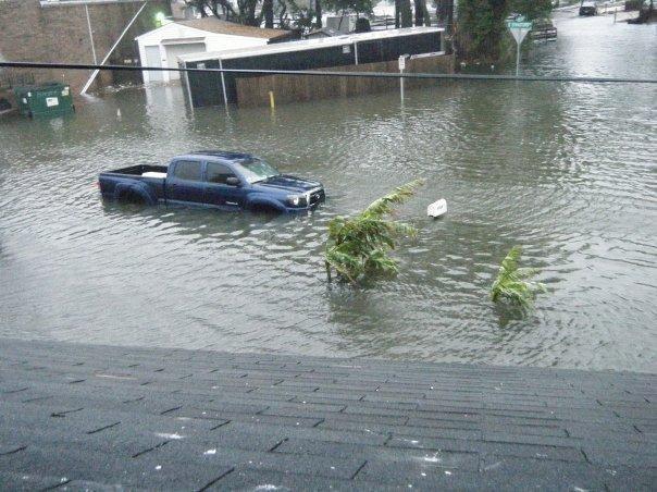
Between 6 am to 4 pm the next day approximately 7.5 inches fell. Chesapeake Bay Bridge Tunnel NOAA Tide Gage
|
|
|
- Hester Willis
- 5 years ago
- Views:
Transcription

1 Ocean Park Alternative Drainage Route Analysis February, 2012
2 November 11 14, 2009 Between 6 am to 4 pm the next day approximately 7.5 inches fell Chesapeake Bay Bridge Tunnel NOAA Tide Gage
3 Hurricane Irene Between 5 pm and 7 am, 3 inches of rain fell Chesapeake Bay Bridge Tunnel NOAA Tide Gage
4 Tidal Flood Frequency Curve based on FEMA Flood Insurance Study City of Virginia Beach (Revised May 4, 2009)

5 Focus: Ocean Park South of Shore Drive

6 Some ground elevations in Ocean Park are BELOW 4 FEET (NAVD 88)* CANNOT PREVENT OVERLAND FLOW NAVD88 is a vertical control datum in the USA. All ground elevations are in NAVD88 unless otherwise stated


7 Finished Floors in the Flood Prone Area

8 2010 Flooding Evaluation Report

9 Tidal Inflows
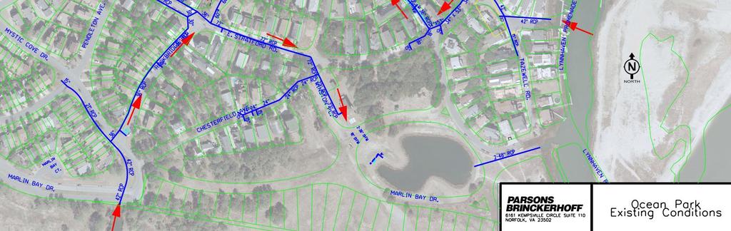
10 Ocean Park South of Shore Drive Drainage Area Isolation Plan

11 Ocean Park South of Shore Drive Drainage Area Isolation Plan
12 Ocean Park South of Shore Drive Drainage Area Isolation Plan PLUG AND REROUTE
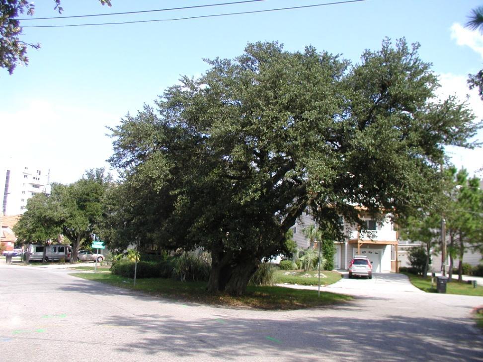
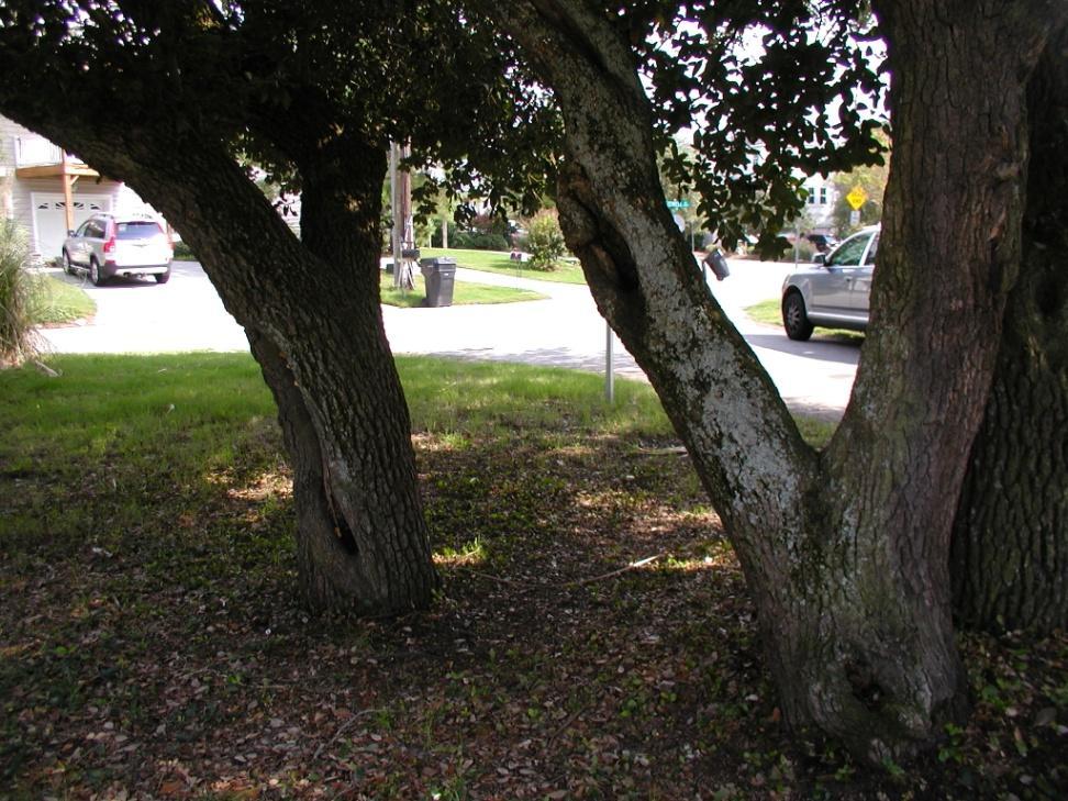

13 LIVE OAKS EVERYWHERE


14 TIDE VALVES AND GATES TIDE VALVE TIDE GATE
15 TIDEFLEX CHECKMATE VALVE Sand Accumulation Maintenance Issues Max Elevation 5.0 Feet (NAVD88)

16 IMMINENT ACTION PLAN IN PROGRESS RECONNECT EXISTING 15 PIPE WITH TEMPORARY WEIR TEMPORARY PLUG AND REROUTE FLOWS
17 IMMINENT ACTION PLAN (TEMPORARY) PROVIDES RELIEF FROM TIDES UP TO APPROXIMATELY 5 FEET (NAVD88) OR 5.9 FEET (MSL) PROVIDES DRAINAGE FOR MOST STORMS INTENSE PERIODS OF RAINFALL WILL RESULT IN TEMPORARY FLOODING APPROXIMATELY 6-9 INCHES IN LOW LYING AREAS DEPENDS ON INTENSITY AND LENGTH OF STORM
18 ALTERNATIVE CONSIDERATIONS ALTERNATE ROUTE ANALYSIS FEASIBILITY AND COST IMPACT TO THE NEIGHBORHOOD CONSIDERATION FOR TREES IN THE AREA
19 ALTERNATIVES A Reroute flows along Dinwiddie Road and through the park B Reroute along East Stratford Road C Install additional parallel 18 along Dupont Circle from Dinwiddie Road to intersection of Chesterfield and Dinwiddie Road
20 REGARDLESS OF THE ALTERNATIVE, TIDAL RELIEF IS ONLY GOOD UP TO AN ELEVATION OF 5.0 FEET NAVD88 (OR 5.9 FEET MSL).


21 ALTERNATIVE A Reroute along Dinwiddie Road and through the park
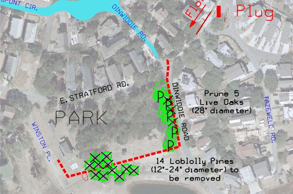
22 Alternative A

23 Alternative A Pros Meets city standard for drainage in this area Only Dinwiddie Road south of East Stratford is disturbed Cons Pruning of 5 Live Oaks and removal of 14 large pines. Construction through the park Duration: 8 months $$$


24 ALTERNATIVE B Reroute westward on East Stratford Road
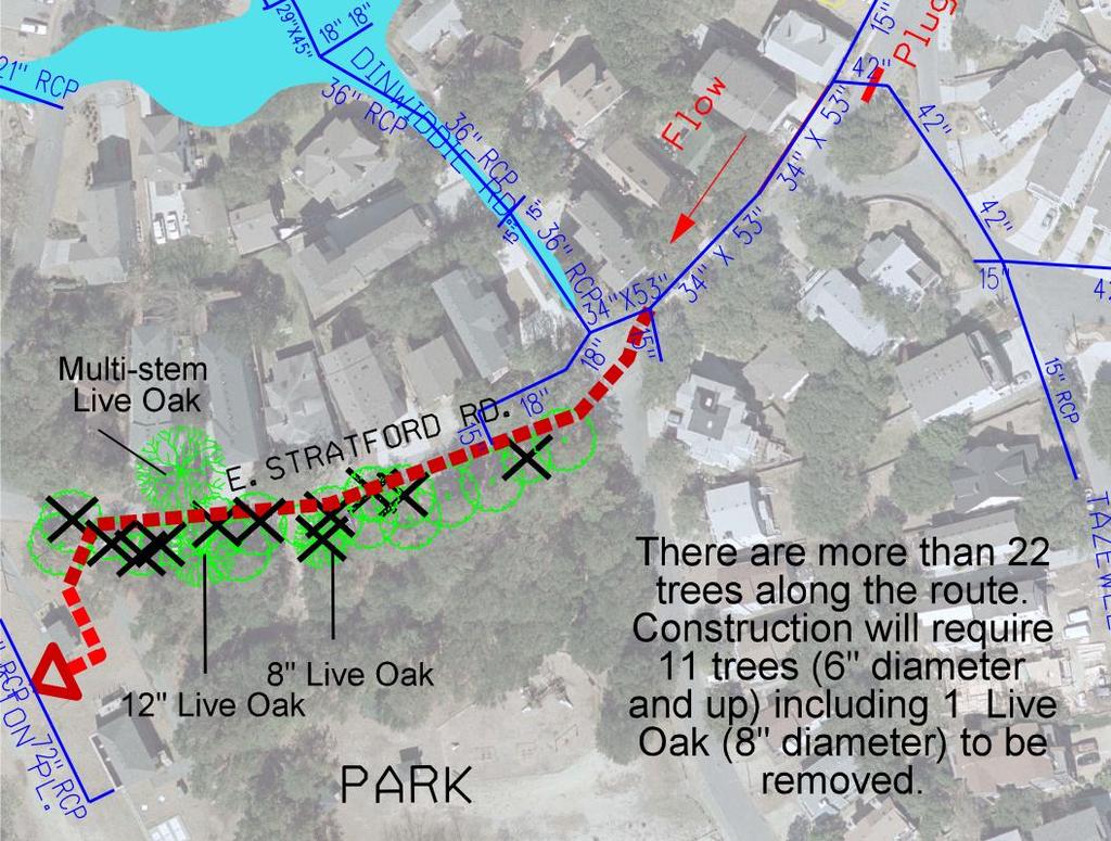
25 Alternative B
 Construction along East Stratford Road (8 months)")
26 Alternative B Pros Meets city standard for drainage in this area Cons Removal of 1 Live Oak and 10 other trees (6 diameter and up) Construction along East Stratford Road (8 months) $$$$


27 ALTERNATIVE C Reroute westward on Dupont Circle with additional pipe
 Cons Flooding will occur during rainstorms with intensities more than 2 in/hour regardless of tidal")
28 Alternative C Pros Provides drainage relief for rainfall intensities up to 2 of rain in 1 hour No tree removals Least Costly of 3 alternatives Shorter construction duration (4 months) Cons Flooding will occur during rainstorms with intensities more than 2 in/hour regardless of tidal levels
29 APPROXIMATE AREA OF FLOODING FOR ALTERNATIVE C LARGE STORMS WITH LARGE INTENSITIES 2-6 IN/HOUR (FLOOD DEPTH 2-6 INCHES)

30 APPROXIMATE AREA OF FLOODING FOR ALTERNATIVE C FOR HURRICANE IRENE: 2.5 INCHES DEPTH FOR 4 HOURS
31 SUMMARY IMMINENT ACTIONS INSTALL TEMPORARY PLUG AT INTERSECTION OF TAZEWELL AND EAST STRATFORD ROAD INSTALL TEMPORARY WEIR RECONNECT ABANDONED 15 PIPE TO PUMP STATION ALTERNATIVES A INSTALL ADDITIONAL PIPE THROUGH PARK B INSTALL ADDITIONAL PIPE WESTWARD ON EAST STRATFORD ROAD C- INSTALL ADDITIONAL 18 PIPE WESTWARD ON DUPONT CIRCLE
32 Alternatives A-C Pros and Cons Alternative Pros Cons A Reroute additional pipe along Dinwiddie Road and through the park B Reroute westward on East Stratford Road Provides drainage for large storms with intensities 3 to 6 in/hour Only Dinwiddie Road south of East Stratford is disturbed Provides drainage for large storms with intensities 3 to 6 in/hour Pruning of 5 Live Oaks and removal of 14 Pines Construction in park and along Dinwiddie Road (8 months) $434,000 Removal of 1 Live Oak and 10 other trees (6 diameter and up) Construction along East Stratford Road (8 months) $454,000 C Reroute additional 18 parallel pipe Provides drainage for large storms with intensities 1 to 2 in/hour Construction does not damage trees Construction along Dupont Circle (4 months) Least Costly ($150,000) May experience some flooding during very intense rainstorms with intensities greater than 2 in/hour. NOTE: REGARDLESS OF THE ALTERNATIVE, TIDAL RELIEF IS ONLY GOOD FOR A TIDAL ELEVATION OF UP TO 5.0 FEET NAVD88 (5.9 FEET M.S.L.)
IRENE: Visitor from the Extratidal World
 IRENE: Visitor from the Extratidal World John Boon Professor Emeritus Virginia Institute of Marine Science School of Marine science College of William and Mary Hurricane Irene did not come to Hampton Roads
Draft for Discussion 11/11/2016
 Coastal Risk Consulting (CRC) Climate Vulnerability Assessment for Village of Key Biscayne Deliverable 1.1 in Statement of Work. Preliminary Vulnerability Assessment Identifying Flood Hotspots Introduction...
LOCATED IN INDIAN RIVER COUNTY PREPARED FOR S.J.R.W.M.D. AND F.W.C.D. DECEMBER, 2003 Updated 2007 Updated May 2014 PREPARED BY
 FELLSMERE WATER CONTROL DISTRICT EAST MASTER DRAINAGE PLAN AND STORMWATER HYDROLOGIC ANALYSIS OF THE GRAVITY DRAINAGE SYSTEM LOCATED BETWEEN THE EAST BOUNDARY, LATERAL U, THE MAIN CANAL, AND DITCH 24 LOCATED
Joint Occurrence and Probabilities of Tides and Rainfall
 Joint Occurrence and Probabilities of Tides and Rainfall City of Virginia Beach, Virginia CIP 7-030, PWCN-15-0014, Work Orders 2 and 5A Final Report Date: October 9, 2017 Submitted to: City of Virginia
Analysis of Tides and Storm Surge from Observational Records in the Delaware Inland Bays
 Analysis of Tides and Storm Surge from Observational Records in the Delaware Inland Bays John Callahan Delaware Geological Survey Coastal GeoTools Conference March 30 April 2, 2015 Charleston, SC Outline
Chapter 5 CALIBRATION AND VERIFICATION
 Chapter 5 CALIBRATION AND VERIFICATION This chapter contains the calibration procedure and data used for the LSC existing conditions model. The goal of the calibration effort was to develop a hydraulic
Florida Flood Risks. Heavy Rainfall. Groundwater. Tidal Flooding. Storm Surge. King Tides. Runoff/Riverine
 Florida Flood Risks Heavy Rainfall Storm Surge Groundwater Tidal Flooding Runoff/Riverine King Tides Sawgrass Mills Mall Sunrise, Florida 15 of rain in 3 days, with most in 24 hours. Mall closed for 3
Rucker Pond. Background
 Rucker Pond Background The Rucker Basin consists of two subbasins (East and West) that drain to a single area known as Rucker Pond. Both subbasins have the same hydraulic parameters, but have different
COASTAL DATA APPLICATION
 2015 Coastal GeoTools Proactive By Design. Our Company Commitment COASTAL DATA APPLICATION Projecting Future Coastal Flood Risk for Massachusetts Bay Bin Wang, Tianyi Liu, Daniel Stapleton & Michael Mobile
Adaptation to Sea Level Rise A Regional Approach
 Adaptation to Sea Level Rise A Regional Approach Project Partners: in Saco Bay, ME Peter Slovinsky, Marine Geologist Maine Geological Survey, Department of Conservation Project Funding from: Saco Bay Hazards
THE NEED FOR AN ADDITIONAL SPILLWAY AT THE SANFORD DAM BOILING SPRING LAKES, NC. Presentation for The Brunswick County Commissioners April 20, 2015
 THE NEED FOR AN ADDITIONAL SPILLWAY AT THE SANFORD DAM BOILING SPRING LAKES, NC Presentation for The Brunswick County Commissioners April 20, 2015 The Sanford Dam Earth Dam constructed in 1961 Drainage
WATER MANAGEMENT REPORT FOR PAGE ESTATES
 WATER MANAGEMENT REPORT FOR PAGE ESTATES SLB Consulting of SW Florida, LLC PO Box 2826 Bonita Springs, FL. 34133 Phone: 239-948-9566 sandra@slbconsult.com C.O.A. # 25395 September 1, 2014 Sandra L. Bottcher
ATLANTIC INTRACOASTAL WATERWAY NORFOLK DISTRICT. Joel F. Scussel, Operations Support Section Dismal Swamp Canal July 27, 2017
 ATLANTIC INTRACOASTAL WATERWAY 1 255 255 255 237 237 237 0 0 0 217 217 217 163 163 163 200 200 200 131 132 122 239 65 53 80 119 27 NORFOLK DISTRICT 110 135 120 252 174.59 112 92 56 62 102 130 102 56 48
Turn and Face the Strange: Economic Impacts of Climate Change Sea Level Rise and Coastal Flooding E2Tech Forum June 21, 2018
 Turn and Face the Strange: Economic Impacts of Climate Change Sea Level Rise and Coastal Flooding E2Tech Forum June 21, 2018 Peter A. Slovinsky, Marine Geologist Maine Geological Survey Image from Chebeague.org
Sea level rise Web GIS Applications
 Florida International University FIU Digital Commons GIS Center GIS Center 2018 Sea level rise Web GIS Applications Zhaohui Fu GIS-RS Center, Florida International University, Fujen@fiu.edu Sheyla Santana
Sea Level Rise and Hurricane Florence storm surge research methodology
 Sea Level Rise and Hurricane Florence storm surge research methodology Hurricane Florence storm surge analysis was conducted using a variety of input sources. In order to determine the maximum storm surge
Weather briefing Strong Coastal Nor easter November 7 th -8 th, 2012
 Weather briefing Strong Coastal Nor easter November 7 th -8 th, 2012 Prepared 1215 PM EDT Wednesday November 7, 2012 Gary Szatkowski NOAA s NJ Forecast Office http://www.erh.noaa.gov/phi/ Purpose of Briefing
Results of Intensity-Duration- Frequency Analysis for Precipitation and Runoff under Changing Climate
 Results of Intensity-Duration- Frequency Analysis for Precipitation and Runoff under Changing Climate Supporting Casco Bay Region Climate Change Adaptation RRAP Eugene Yan, Alissa Jared, Julia Pierce,
L OWER N OOKSACK R IVER P ROJECT: A LTERNATIVES A NALYSIS A PPENDIX A: H YDRAULIC M ODELING. PREPARED BY: LandC, etc, LLC
 L OWER N OOKSACK R IVER P ROJECT: A LTERNATIVES A NALYSIS A PPENDIX A: H YDRAULIC M ODELING PREPARED BY: LandC, etc, LLC TABLE OF CONTENTS 1 Introduction... 1 2 Methods... 1 2.1 Hydraulic Model... 1 2.2
Evaluation of Storm Tide Measurements at Panama City Beach, FL
 Evaluation of Storm Tide Measurements at Panama City Beach, FL 1993-2007 Prepared by Mark E. Leadon Beaches and Shores Resource Center Florida State University May 2009 Prepared for Florida Department
Hurricane Matthew. Life Threatening Flash Flooding Likely. National Weather Service Wilmington NC. Josh Weiss, Meteorologist
 Hurricane Matthew Life Threatening Flash Flooding Likely Threat Assessment for northeast South Carolina & southeast North Carolina National Weather Service Wilmington NC 630 PM EDT Friday October 7, 2016
BRANDON LAKES AVENUE PRE AND POST CONDITIONS DRAINAGE REPORT
 BRANDON LAKES AVENUE PRE AND POST CONDITIONS DRAINAGE REPORT Hillsborough County Public Works County Center, 22nd Floor 601 E. Kennedy Blvd. Tampa, FL 33602 BRANDON LAKES AVENUE DRAINAGE IMPROVEMENTS Capital
CLIMATE READY BOSTON. Climate Projections Consensus ADAPTED FROM THE BOSTON RESEARCH ADVISORY GROUP REPORT MAY 2016
 CLIMATE READY BOSTON Sasaki Steering Committee Meeting, March 28 nd, 2016 Climate Projections Consensus ADAPTED FROM THE BOSTON RESEARCH ADVISORY GROUP REPORT MAY 2016 WHAT S IN STORE FOR BOSTON S CLIMATE?
Significant Coastal Storm Today through Thursday, 11/7-8. Weather Briefing
 Significant Coastal Storm Today through Thursday, 11/7-8 Weather Briefing Prepared 10:00 am EST Wednesday, November 7, 2012 Presented by Gary Conte, Warning Coordination Meteorologist NOAA s National Weather
HURRICANE IRENE. CONFERENCE CALL BRIEFING SLIDES Saturday August 27, :30 AM
 HURRICANE IRENE CONFERENCE CALL BRIEFING SLIDES Saturday August 27, 2011 8:30 AM NHC TRACK AND CONE HURRICANE IRENE WATCHES/WARNINGS Hurricane Warning along south coast including all of Cape Cod and Islands
Climate Adaptation Challenges for Boston s Water and Sewer Systems
 National Association of Flood & Stormwater Management Agencies Climate Adaptation Challenges for Boston s Water and Sewer Systems John P Sullivan P.E. October 15,2014 Boston 1630 Boston 1630-2012 Boston
New Jersey Department of Transportation Extreme Weather Asset Management Pilot Study
 New Jersey Department of Transportation Extreme Weather Asset Management Pilot Study Overview Prepared for: June 26, 2018 Introduction Overview of Pilot Study New Jersey s Climate New Jersey s Transportation
Satellite and Radar. 5:55 am Infrared Satellite with Surface Wind Arrows. 6:15 am Ruskin Doppler Radar. Large southerly wind field
 Satellite and Radar 5:55 am Infrared Satellite with Surface Wind Arrows 6:15 am Ruskin Doppler Radar Large southerly wind field Developing showers rotating onshore NHC Forecast Hurricane Warning Big Bend
John Callahan (Delaware Geological Survey) Kevin Brinson, Daniel Leathers, Linden Wolf (Delaware Environmental Observing System)
 Kevin Brinson, Daniel Leathers, Linden Wolf (Delaware Environmental Observing System)") John Callahan (Delaware Geological Survey) Kevin Brinson, Daniel Leathers, Linden Wolf (Delaware Environmental Observing System) Delaware is extremely vulnerable to the impacts of coastal flooding Tropical
John Callahan (Delaware Geological Survey) Kevin Brinson, Daniel Leathers, Linden Wolf (Delaware Environmental Observing System) Delaware is extremely vulnerable to the impacts of coastal flooding Tropical
VILLAGE COUNCIL STORMWATER REPORT JULY 23, 2016 STORM EVENT
 VILLAGE COUNCIL STORMWATER REPORT JULY 23, 2016 STORM EVENT STORM RAINFALL AND RADAR IMAGERY Total rainfall 4.99 inches 2.74 inches between 5:40 and 7:10, then a lull until 9:30 2.04 inches between 9:30
Hurricane Matthew Life Threatening Flash Flooding Likely
 Hurricane Matthew Life Threatening Flash Flooding Likely Threat Assessment for northeast South Carolina & southeast North Carolina National Weather Service Wilmington NC 12 AM EDT Saturday October 8, 2016
3.0 TECHNICAL FEASIBILITY
 3.0 TECHNICAL FEASIBILITY 3.1 INTRODUCTION To enable seasonal storage and release of water from Lake Wenatchee, an impoundment structure would need to be constructed on the lake outlet channel. The structure
3301 Rickenbacker Causeway, Miami, FL 33149
 Virginia Key and Miami Beach 2016 King Tide Report and Projections (to 2045) using: 3301 Rickenbacker Causeway, Miami, FL 33149 *THIS REPORT IS PROVIDED SUBJECT TO THE COASTAL RISK CONSULTING, LLC, PRINTED
Sea-Level Rise Impacts on South Florida
 Sea-Level Rise Impacts on South Florida Keren Prize Bolter, PhD Science Director, Coastal Risk Consulting. LLC 5/3/16 FAQ list What is happening? What impacts are we already seeing? Just how vulnerable
Chapter 7 Mudflow Analysis
 Chapter 7 Mudflow Analysis 7.0 Introduction This chapter provides information on the potential and magnitude of mud floods and mudflows that may develop in Aspen due to rainfall events, snowmelt, or rain
Chapter 7 Mudflow Analysis
 Chapter 7 Mudflow Analysis 7.0 Introduction This chapter provides information on the potential and magnitude of mud floods and mudflows that may develop in Aspen due to rainfall events, snowmelt, or rain
Planning for Annapolis Sea Level Rise and Future Extreme Water Levels
 Planning for Annapolis Sea Level Rise and Future Extreme Water Levels U.S. Naval Academy Sea Level Rise Advisory Council 31 October 2017 CAPT Emil Petruncio, USN (Ret.), PhD Associate Professor Gina Henderson
Ecological Context - Urban settlements are part of their surrounding ecosystem. Austin
 Ecological Context - Urban settlements are part of their surrounding ecosystem Austin Ecotone Division between West and East Flyway Uplift River Balcones Escarpment Central Texas Climate The principal
Weather Briefing Mixed Winter Storm Event February 26-27, 2013
 Weather Briefing Mixed Winter Storm Event February 26-27, 2013 Prepared 1200 PM EST Tuesday, February 26th, 2013 Joe Miketta NOAA s NJ Forecast Office http://www.erh.noaa.gov/phi/ Purpose of Briefing Briefing
COMMUNITY EMERGENCY RESPONSE TEAM FLOODS INTRODUCTION
 INTRODUCTION Floods are one of the most common hazards in the United States. A flood occurs any time a body of water rises to cover what is usually dry land. Flood effects can be local, impacting a neighborhood
Superstorm Sandy Willis Re s post-event field damage survey preliminary report
 HURRICANE DAMAGE SURVEY REPORT event November 8, 2012 Superstorm Sandy Willis Re s post-event field damage survey preliminary report Immediately after Sandy s landfall, representatives of Willis Re s Catastrophe
Las Colonias Subdivision September 2010 Flood Study
 Las Colonias Subdivision September 2010 Flood Study Curtis Beitel, P.E., CFM Scott Muchard, P.E. Project Engineer William Badini, CFM Senior Meteorologist Location Map Background Los Colonias Subdivision
CASE STUDY #9 - Brushy Fork Dam, Sugar Grove, West Virginia
 CASE STUDY #9 - Brushy Fork Dam, Sugar Grove, West Virginia Brushy Fork Dam is a flood control structure built by the Soil Conservation Service southeast of the city of Franklin in Pendleton County, West
SEVERE WEATHER 101. Flood Basics
 SEVERE WEATHER 101 Flood Basics What is flooding? Flooding is an overflowing of water onto land that is normally dry. Floods can happen during heavy rains, when ocean waves come on shore, when snow melts
Mapping of Future Coastal Hazards. for Southern California. January 7th, David Revell, Ph.D. E.
 Mapping of Future Coastal Hazards for Southern California January 7th, 2014 David Revell, Ph.D. drevell@esassoc.com E. Vandebroek, 2012 Outline Coastal erosion hazard zones Flood hazard zones: Coastal
Appendix E Guidance for Shallow Flooding Analyses and Mapping
 Appendix E Guidance for Shallow Flooding Analyses and Mapping E.1 Introduction Different types of shallow flooding commonly occur throughout the United States. Types of flows that result in shallow flooding
FHWA - HIGHWAY HYDROLOGY
 The unit peak discharge is computed with Equation 5.6 by interpolating c 0, c, and c Table 5.5 using a type II distribution. The peak discharge is also calculated as follows. from Variable SI Unit U Unit.5444
HAZUS th Annual Conference
 HAZUS 2014 7 th Annual Conference VALIDATING THE HAZUS COASTAL SURGE MODEL FOR SUPERSTORM SANDY Spiridon Katehis 1 Jordan T. Hastings 1 1 University of Southern California 1 Superstorm Sandy, Oct 12 2
Estimating the Mean Temperature and Salinity of the Chesapeake Bay Mouth
 Estuaries Vol. 25, No. 1, p. 1 5 February 2002 Estimating the Mean Temperature and Salinity of the Chesapeake Bay Mouth RICARDO A. LOCARNINI,LARRY P. ATKINSON*, and ARNOLDO VALLE-LEVINSON Center for Coastal
Environmental Geology Lab 6 Coastal Hazards. Tropical cyclones are classified based on substained wind speed as indicated below.
 Environmental Geology Lab 6 Coastal Hazards page - 1 In the continental United States there are two fundamental types of shorelines. Tectonically passive margins that have low relief and consist of smooth
Coastal Emergency Risks Assessment - CERA Real-Time Storm Surge and Wave Visualization Tool
 Coastal Emergency Risks Assessment - CERA Real-Time Storm Surge and Wave Visualization Tool Introduction This document provides guidance for using the Coastal Emergency Risks Assessment (CERA) visualization
Weather Briefing. Coastal Storm Monday-Wednesday Dec 8-10, National Weather Service. Prepared 12/8/14 6:30 AM
 Weather Briefing Coastal Storm Monday-Wednesday Dec 8-10, 2014 National Weather Service http://www.weather.gov/nyc Prepared 12/8/14 6:30 AM Overview of Potential Hazards A strong low pressure system will
UNDERSTANDING STORM TIDES
 UNDERSTANDING STORM TIDES Run from the water, hide from the wind.. CATEGORY CATEGORY CATEGORY CATEGORY CATEGORY 1 2 3 4 5 WIND 74-95 mph 64-82 knots 96-110 mph 83-95 knots 111-130 mph 96-113 knots 131-155
Coastal Resiliency: Planning for Natural Variability and Recovering from Extreme Events
 Coastal Resiliency: Planning for Natural Variability and Recovering from Extreme Events Stephanie Showalter, J.D., M.S.E.L. Director, National Sea Grant Law Center University of Mississippi Coastal Hazards
How does erosion happen?
 How does erosion happen? By National Geographic, adapted by Newsela staff on 10.03.17 Word Count 682 Level 830L These rock formations, in Bryce Canyon National Park, Utah, are called hoodoos. Although
Floods. Floods COMMUNITY EMERGENCY RESPONSE TEAM FLOODS CONTENT INSTRUCTOR GUIDANCE
 Floods Floods Introduce this topic by explaining that floods are one of the most common hazards in the United States. A flood occurs any time a body of water rises to cover what is usually dry land. Display
NWS HURRICANES June 3, 2015
 NWS HURRICANES June 3, 2015 Hurricane Season June 1 November 30 2 What s the concern? All tropical systems passing within 125nm of central Maryland since 1950 Mid-Atlantic Hurricanes Greatest Risk: August
5/25/2017. What is projected for Coastal texas? PROTECTING CRITICAL WATER INFRASTRUCTURE FROM SEA LEVEL RISE
 PROTECTING CRITICAL WATER INFRASTRUCTURE FROM SEA LEVEL RISE What is projected for Coastal texas? Mean Sea Level has risen 3 18 to 37 above Mean Sea Level 1800-1992 1992-2015 2030 2060 2100 Mean Sea Level
SLOSH New Orleans Basin 2012 Update
 SLOSH New Orleans Basin 2012 Update Michael Koziara Science and Operations Officer National Weather Service Slidell, LA The Basics What is storm surge? What is SLOSH? Details Assumptions Inundation = Storm
Coastal Storms of the New Jersey Shore
 Coastal Storms of the New Jersey Shore Dr. Steven G. Decker Dept. of Environmental Sciences School of Environmental and Biological Sciences Rutgers University May 25, 2011 Overview Threats Historical Examples
PRELIMINARY DRAFT FOR DISCUSSION PURPOSES
 Memorandum To: David Thompson From: John Haapala CC: Dan McDonald Bob Montgomery Date: February 24, 2003 File #: 1003551 Re: Lake Wenatchee Historic Water Levels, Operation Model, and Flood Operation This
Presented by Jerry A. Gomez, P.E. National Hydropower Association Northeast Regional Meeting - September 17, 2009
 Presented by Jerry A. Gomez, P.E. National Hydropower Association Northeast Regional Meeting - September 17, 2009 Defining Probable Maximum Precipitation (PMP) PMP is the theoretically greatest depth of
ERDC Support for Hurricane Sandy
 ERDC Support for Hurricane Sandy Chris Massey, CHL; Aaron Byrd, CHL; Nawa Pradhan, CHL; Jeff Melby, CHL; Jane Smith, CHL; Robert Walker, ITL; and Jennifer Wozencraft, JALBTCX ERDC Support for Hurricane
Eastern Shore Weather and Climate. Bill Sammler Warning Coordination Meteorologist National Weather Service Wakefield, VA
 Eastern Shore Weather and Climate Bill Sammler Warning Coordination Meteorologist National Weather Service Wakefield, VA About The NWS The National Weather Service is: A Federal Government Agency Part
FOR PROJECTS INITIATED AFTER NOVEMBER 1, 2008 ITEM 716 EMBANKMENT EARTH OUTLET SEDIMENT TRAP
 AFTER NOVEMBER 1, 2008 ITEM 716 EMBANKMENT EARTH OUTLET SEDIMENT TRAP 716.1 Description. This work shall consist of furnishing, installing, maintaining, and removing temporary erosion protection and sediment
PENNSYLVANIA DEPARTMENT OF TRANSPORTATION ENGINEERING DISTRICT 3-0
 PENNSYLVANIA DEPARTMENT OF TRANSPORTATION ENGINEERING DISTRICT 3-0 LYCOMING COUNTY S.R.15, SECTION C41 FINAL HYDROLOGIC AND HYDRAULIC REPORT STEAM VALLEY RUN STREAM RELOCATION DATE: June, 2006 REVISED:
MEMORANDUM FOR SWG
 MEMORANDUM FOR SWG-2007-1623 Subject: Jurisdictional Determination (JD) for SWG-2007-1623 on Interdunal Wetlands Adjacent to Traditional Navigable Waters (TNWs) Summary The U.S. Environmental Protection
Monitoring Hurricane Rita Inland Storm Surge
 Monitoring Hurricane Rita Inland Storm Surge By Benton D. McGee, Roland W. Tollett, and Burl B. Goree Pressure transducers (sensors) are accurate, reliable, and cost-effective tools to measure and record
Field Research Facility
 Field Research Facility Sea Level Rise Observations of Sea Level rise Forces driving change Predicting future Sea Level rise Response of land surface Storm inundation coupled with Sea Level Dr. Jesse McNinch
A HYDROLOGIC STUDY OF THE EFFECTS OF URBAN DEVELOPMENT ON STORM RUNOFF: A CASE STUDY IN QUEENS, NY ABSTRACT
 154 A HYDROLOGC STUDY OF THE EFFECTS OF URBAN DEVELOPMENT ON STORM RUNOFF: A CASE STUDY N QUEENS, NY Monica Tsang-Rakovan, Kevin J. Phillips, Khalid Bajwa, John Ferrelli, Fanning, Phillips and Molnar Fanning,
Hurricane Harvey: SE Texas Impacts. 10 PM CDT UPDATE Friday, August 25, 2017 Prepared by: Lance Wood
 Hurricane Harvey: SE Texas Impacts 10 PM CDT UPDATE Friday, August 25, 2017 Prepared by: Lance Wood Latest Observations Hurricane Harvey making landfall this evening near Rockport as a category 4 hurricane.
Moving Freshwater to the Ocean: Hydrology-Ocean Model Coupling
 Moving Freshwater to the Ocean: Hydrology-Ocean Model Coupling Cheryl Ann Blain 1, Tim Campbell 1, Song Yang 2, Aubrey Dugger 3, Paul Martin 1, Tommy Jenson 1 Naval Research Laboratory 1 Oceanography Division,
A Cloud-Based Flood Warning System For Forecasting Impacts to Transportation Infrastructure Systems
 A Cloud-Based Flood Warning System For Forecasting Impacts to Transportation Infrastructure Systems Jon Goodall Associate Professor, Civil and Environmental Engineering Associate Director, Link Lab April
Coastal Flood Risk Study Project for East Coast Central Florida Study Area
 Coastal Flood Risk Study Project for East Coast Central Florida Study Area St Lucie County, Florida Flood Risk Review Meeting March 28, 2017 Introductions Risk MAP Project Team FEMA Region IV BakerAECOM,
Boston Coastal Flooding Analysis and Mapping
 Boston Coastal Flooding Analysis and Mapping Philip Orton, Dara Mendeloff, Jane Mills, Malgosia Madajewicz Funding This research was funded by the National Oceanic and Atmospheric Administration (NOAA)
WEST NORRITON TOWNSHIP
 WEST NORRITON TOWNSHIP SANITARY SEWER SYSTEM INFLOW AND INFILTRATION STUDY November 2013 Rettew Associates, Inc. 3020 Columbia Avenue Lancaster, PA 17603 RECOMMENDATIONS The top four priorities for inflow
YELLOWSTONE RIVER FLOOD STUDY REPORT TEXT
 YELLOWSTONE RIVER FLOOD STUDY REPORT TEXT TECHNICAL REPORT Prepared for: City of Livingston 411 East Callender Livingston, MT 59047 Prepared by: Clear Creek Hydrology, Inc. 1627 West Main Street, #294
Hydrologic Briefing Tropical Storm Harvey
 Hydrologic Briefing Tropical Storm Harvey 10:30 AM CDT Sunday, August 27, 2017 Prepared by: John Metz NWSCorpus www.weather.gov/corpuschristi Situation Overview Tropical Storm Harvey Harvey to remain a
ovember 2008 Antigua and Barbuda Meteorological Service
 ovember 2008 Antigua and Barbuda Meteorological Service The Atlantic Hurricane Season Summary 2008 Special Focus on Antigua and Barbuda The Season in Brief Sixteen (16) named storms formed in the Atlantic
Randall W. Parkinson, Ph.D., P.G. Institute of Water and Environment Florida International University
 An Update on Adaptation Action Activities Undertaken Since Completion of the City of Satellite Beach (FL) Vulnerability Assessment to Rising Seas (2010) Randall W. Parkinson, Ph.D., P.G. Institute of Water
MIAMI-SOUTH FLORIDA National Weather Service Forecast Office
 MIAMI-SOUTH FLORIDA National Weather Service Forecast Office http://www.weather.gov/miami June 2015 South Florida Weather Summary Dry East, Wet West...Drought Remains SE Florida July 3, 2015: Depending
New Mapping, Recent Events What do we know? June 9, 2011
 New Mapping, Recent Events What do we know? June 9, 2011 e FEMA Mapping Process Current Flood Insurance Rate Maps (FIRMs) or Floodplain Maps date back to the early 1970 s. The District contracted with
Weather briefing Strong Coastal Nor easter November 7 th -8 th, 2012
 Weather briefing Strong Coastal Nor easter November 7 th -8 th, 2012 Prepared 1245 PM EDT Tuesday November 6, 2012 Gary Szatkowski NOAA s NJ Forecast Office Weather.gov/phi Purpose of Briefing Briefing
Pre-Disaster Natural Hazard Mitigation Plan Guilford, Connecticut History of Hazard Mitigation Planning Authority Disaster Mitigation Act of 2000 (ame
 Pre-Disaster Natural Hazard Mitigation Plan Guilford, Connecticut History of Hazard Mitigation Planning Authority Disaster Mitigation Act of 2000 (amendments to Stafford Act of 1988) Presented by: David
2012 Rainfall, Runoff, Water Level & Temperature Beebe Lake Wright County, MN (# )
") www.fixmylake.com 18029 83 rd Avenue North Maple Grove, MN 55311 mail@freshwatersci.com (651) 336-8696 2012 Rainfall, Runoff, Water Level & Temperature Beebe Lake Wright County, MN (#86-0023) Prepared
www.fixmylake.com 18029 83 rd Avenue North Maple Grove, MN 55311 mail@freshwatersci.com (651) 336-8696 2012 Rainfall, Runoff, Water Level & Temperature Beebe Lake Wright County, MN (#86-0023) Prepared
Winter Storm Today into Tonight
 Winter Storm Today into Tonight Decision Support Briefing #2 As of 6 AM Wednesday, February 20, 2019 What Has Changed? Minor adjustments to forecast snow and ice amounts. Main Points Hazard Impacts Location
Urban Street-Scale Hydrodynamic Flood Modeling of Micro-Burst Rainfall
 Urban Street-Scale Hydrodynamic Flood Modeling of Micro-Burst Rainfall Dr. Jon Derek Loftis Asst. Research Scientist, VA Inst. of Marine Science Sridhar Katragadda Systems Analyst, City of Virginia Beach
Hurricane Lane. Hawaiian Islands, August By Ian Robertson 1, Ph.D., P.E.
 Hurricane Lane Hawaiian Islands, August 2018 By Ian Robertson 1, Ph.D., P.E. Hurricane Lane, a major Pacific Ocean hurricane, narrowly missed making landfall on the main Hawaiian Islands, but still caused
NOAA s National Weather Service Philadelphia/Mt. Holly NJ
 Next Briefing Package: Friday, October 2, 2015 no later than 300 PM Hazards and Impacts: Overview: A dangerous weather pattern still threatens our region. Threats include very heavy rainfall, inland river
A Synopsis of the December 1-4, 2007 Storm Events
 A Synopsis of the December 1-4, 27 Storm Events An aerial view of the flooded I-5 overpass looking south Flooding in Chehalis. (Associated Press ) Maryanne Reiter, Hydrologist Weyerhaeuser Co. The Wind
A Prepared Marylander Creates a Resilient Maryland
 Maryland Emergency Management Agency Operations Directorate Hazardous Winter Weather Outlook Briefing March 5, 2013 0800 A Prepared Marylander Creates a Resilient Maryland A strong low pressure will track
TROPICAL STORM NATE BRIEFING
 TROPICAL STORM NATE BRIEFING 5:00 AM CDT Friday, October 6, 2017 Prepared by: NWS NWSNewOrleans www.weather.gov/neworleans Situation Overview No significant changes to the track forecast this morning.
Coastal flooding in Hong Kong
 Coastal flooding in Hong Kong Wyss W.-S. Yim Department of Earth Sciences, The University of Hong Kong / Guy Carpenter Asia-Pacific Climate Impact Centre, City University of Hong Kong Why is this important?
NOAA s National Weather Service Philadelphia/Mt. Holly NJ. Summary. Changes
 Summary A crippling and potentially historic east coast snow storm will lead to blizzard conditions and major coastal flooding for portions of the area this weekend. Changes Blizzard Warning has been expanded
Hurricane Wilma Post Storm Data Acquisition Estimated Peak Wind Analysis and Storm Tide Data. December 27, 2005
 Hurricane Wilma Post Storm Data Acquisition Estimated Peak Wind Analysis and Storm Tide Data December 27, 2005 Hurricane Wilma was the sixth major hurricane of the record-breaking 2005 Atlantic hurricane
Groundwater dynamics and surface water-groundwater interaction in a prograding delta island, Louisiana, USA
 Supplementary Information Groundwater dynamics and surface water-groundwater interaction in a prograding delta island, Louisiana, USA Michael T. O Connor 1* and Kevan B. Moffett 1,2 1 Department of Geological
Page G Crow Wing County Multi-Hazard Mitigation Plan, 2017
 Table G - 10. s Identified by the () (From Crow Wing County Master Chart) 1 5 All- Hazards All- Hazards Work to ensure that all Crow Wing County residents are aware of and sign-up for the County s Emergency
Lessons Learned and Shared
 Lessons Learned and Shared Plan for the worst. Hope for the best. Remember that hope is not a strategy. Agnes 8 Lessons 1. Identify Susceptible Communities 2. Develop a Plan 3. Threat Recognition 4. Review
WELCOME Lake Wabukayne OPEN HOUSE
 WELCOME Lake Wabukayne Sediment Removal Project OPEN HOUSE We are here to: Update you, the community, on recent developments and activities at Lake Wabukayne Present the preferred alternative and receive
SECTION 5: RISK ASSESSMENT FLOOD. Table of Contents
 Table of Contents SECTION 5 Risk Assessment... 5-1 5.1 Hazard Profile... 5-1 5.2 Hazard Description... 5-1 Previous Occurrences and Losses... 5-39 Probability of Future Occurrences... 5-56 Climate Change