INTRODUCTION Water resources are vitally important for the future of humankind. Groundwater from karst aquifers is among the most important drinking w
|
|
|
- Avice York
- 5 years ago
- Views:
Transcription
1 Vulnerability Mapping for the Protection of Carbonate (Karst) Aquifers (Ramallah-Al Bireh District) Eng. Amjad da Assi House of fw Water and de Environment May, 2007
2 INTRODUCTION Water resources are vitally important for the future of humankind. Groundwater from karst aquifers is among the most important drinking water resource inthe West Bank. The protection of groundwater within karst aquifers to assure its quality for potable use should be one of the Palestinians priorities. Theterm vulnerability isnot restricted to groundwater but isused in a wide sense to describe the sensitivity of whatever to any kind of stress. The aim from this lecture is to present an integrated method that addresses the question of groundwater vulnerability and risk in karst environments.
3 Conceptual Model of a Karst Aquifer
4 The Origin-Pathway Pathway-Target Model
5 General Concept of the PI Method It is a GIS-based approach. It is sb based on an origin-pathway- target model.
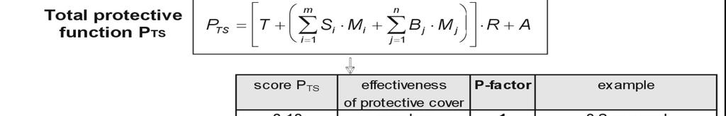
6 PI - Method (P) Protective ti Cover (I) Infiltration Conditions Thickness, Hydraulic Conductivity, Degree of Karstification, Joints / faults. Type of infiltration, Flow concentration and degree of by-passing the protective cover.
7 P-Factor: the effectiveness of the production cover above the groundwater table. I- Factor: : reduction of the protection cover by the bypassing flow.
8 Simple Flow Chart for the PI Method The vulnerability map is obtained by intersecting the Pmap with the Imap. The Pmap shows the effectiveness of the productive cover as afunction of the thickness and permeability of all the strata above the ground water surface. The Imap shows the degree to which the protective cover is bypassed. It is obtained by intersecting the map showing the catchment areas of the sinking streams with the so-called I map, which shows the distribution of lateral, surface and subsurface flow.

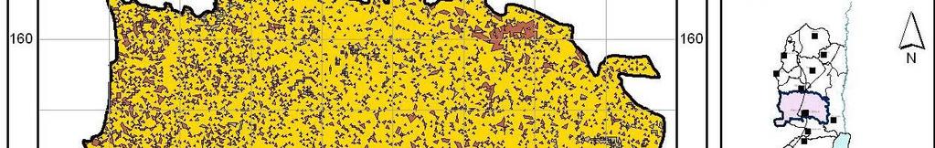
9 P-Map
10 Top Soil (T-Factor) Soil type Measured / Estimated FC (mm/m) Weighted Value (T) Terra Rossa, Brown Rendzinas and Pale Rendzinas Brown Rendzinas and Pale Rendzinas Grumusols Brown Lithosols and Loessial Serozems Brown Lithosols and Loessial Arid Brown Soil Loessial Serozems
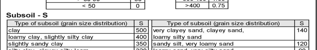
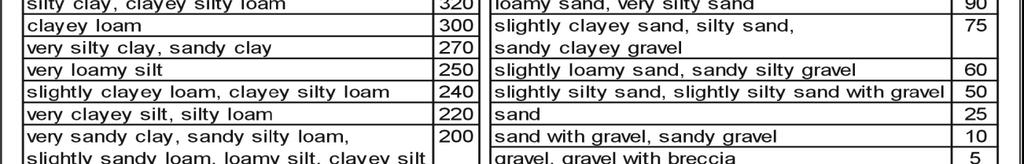
11 Sub-soil (S-Factor) Soil type Sub-soil type Weighted Value (S) Terra Rossa, Brown Rendzinas and Pale Rendzinas Clay 500 Brown Rendzinas and Pale Rendzinas Clayey loam 300 Grumusols Clay 500 Brown Lithosols and Loessial Serozems Slightly clayey sand 75 Brown Lithosols and Loessial Arid Brown Soil Loamy 250 Loessial Serozems Slightly clay 320
12
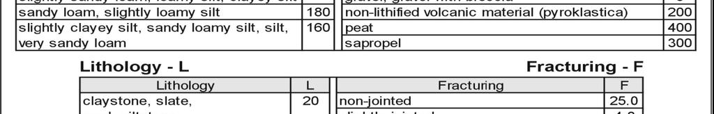
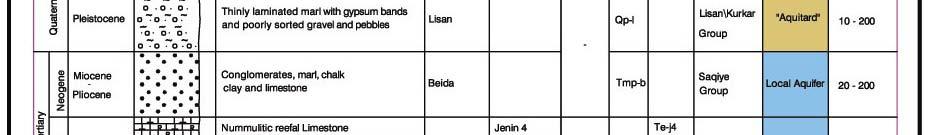
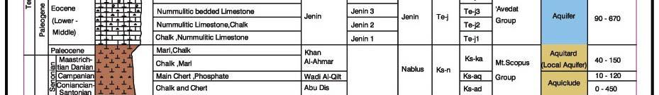
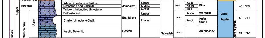
13 Lithology and Fracturing (L & F Factors) Lithology Lithology Value (L) Fracturing Value (F) Nari (surface crust) and alluvium gravels and fan deposits 5 4 Conglomerates, marl, chalk, clay and limestone 5 20 Reefal limestone, Nummulitic limestone and chalk 5 0.5, chalk and chert White limestone, stilolithes dolomite and thin bedded limestone Karstic dolomite, dolomite, chalky limestone Limestone and dolostone, chalk Reefal limestone, karstic limestone, dolomite, dolomite limestone
14 Groundwater Recharge (R-Factor) When the geological formations that form the main aquifers are outcropping, the following Rainfall-Recharge Recharge equations were applied. R=0.6 (P 285) P > 700 mm R=0.46 (P -159) 700 mm > P >456 mm R=0.3 (P) 456 mm > P where: R=R Recharge from rainfall lli in mm/yr P = Annual rainfall in mm/yr.
15 Rainfall
16 Groundwater Recharge (R-Factor) Mean annual rainfall Recharge R value (mm) (mm/yr)
17 P-Map Finally, P-map was prepared based on COST 620 mathematical equations as shown below. n PTS = T + S. M + B i M i R + i =1 A The value P TS was calculated for each cell by using the previous described parameters maps, Hence, P-map is grid map with cell size (20m X 20m) where each has its own P TS. According to the adapted P classification, It was found that about 5km 2 (0.6% of total area) is classified as moderate protective, and 637 km 2 (76.7% of total area) is high protective whereas 189 km 2 (22.7%of total area) is very high protective areas.
18 P-Map


19 I-Map
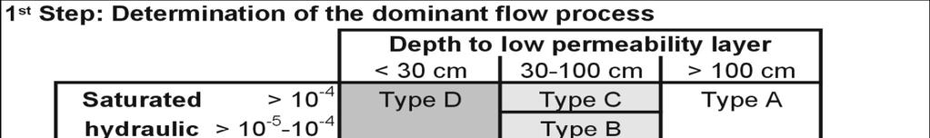
20 Determination of Dominant Flow The dominant flow process is assessed on the basis of the top soil permeability and the presence of low permeable layers.
21 Determination of Dominant Flow The dominant flow process is assessed on the basis of the top soil permeability and the presence of low permeable layers. Type A- Infiltration and subsequent percolation. Type B Fast subsurface storm flow. Tp Type C Very fast subsurface flow. Type D Saturated surface flow. Type E Hortonian surface flow rarely (only during storm rainfall). Type F Hortonian surface flow frequently (also during low intensive precipitation).
22 Determination of Dominant Flow Soil Type Dominant Flow Terra Rossa, Brown Rendzinas and Pale Rendzinas Hortonian Surface Flow F Brown Rendzinas and Pale Rendzinas Infiltration and Subsequent Percolations A Grumusols Hortonian Surface Flow F Brown Lithosolsand Loessial lserozems St Saturated tdsurface Flow D Brown Lithosols and Loessial Arid Brown Soil Saturated Surface Flow D Loessial Serozems Saturated Surface Flow D Flow Type
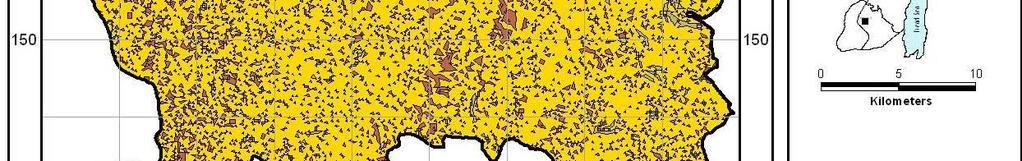
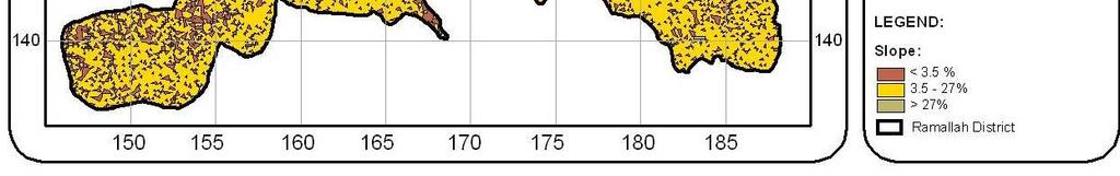
23 Determination of Slope Contour Map Slope Map
24 Determination of I Factor


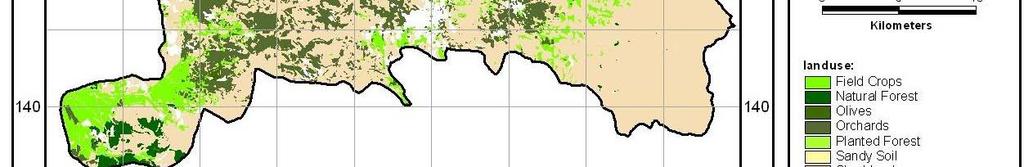
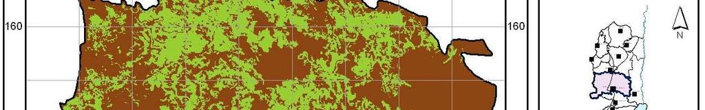
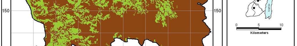
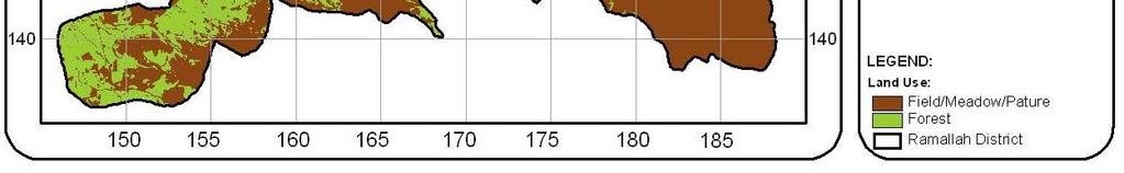
25 Land Use Map Land Use Map PI- LU Map


26 I Map Forests Dominant Flow Type Slope % % > 27 % Type A Type D Type F Fields Dominant Flow Type Slope % % > 27 % Type A Type D Type F
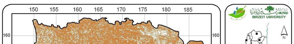
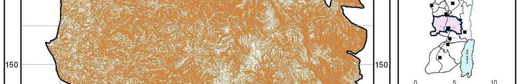
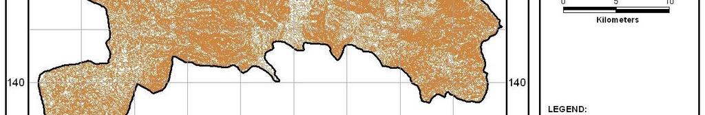
27 Surface Catchment Map
28 Surface Catchment Map
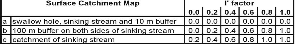
29 I-Map Surface Catchment Map I' Factor a 10 m buffer on both sides of sinking wadis b 100 m buffer on both sides of sinking wadis c Catchment of sinking wadis
30 Determination of Dominant Flow The dominant flow process is assessed on the basis of the top soil permeability and the presence of low permeable layers. Type A- Infiltration and subsequent percolation. Type B Fast subsurface storm flow. Tp Type C Very fast subsurface flow. Type D Saturated surface flow. Type E Hortonian surface flow rarely (only during storm rainfall). Type F Hortonian surface flow frequently (also during low intensive precipitation).
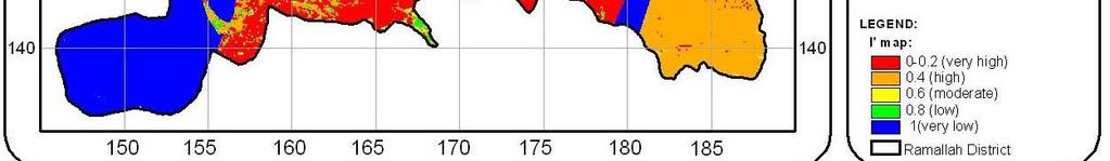
31 PI -Map The vulnerability map shows the intrinsic vulnerability and the natural protection of the uppermost aquifer. The map shows the spatial distribution of the protection factor π, which is obtained by multiplying li l i the P and I factors: π = P I The areas on each of thethree maps are assigned to one of five classes, symbolized by five colors: from red for high risk to blue for low risk. Consequently, one legend can be used for all three maps.
32 PI -Map
33 PI -Map From the final PI-map, 5% of the study area ( km 2 ) is classified as extreme, 41% (340.7 km 2 )as high, 31% (257.6 km 2 ) as moderate, 18% ( km 2 ) as low and 5% ( km 2 ) as very low. Hence, Ramallah-Al Bireh district is classified as high-to- moderate vulnerable.
34 THANK YOU
Hydrogeology of Karst NE Wisconsin. Dr. Maureen A. Muldoon UW-Oshkosh Geology Department
 Hydrogeology of Karst NE Wisconsin Dr. Maureen A. Muldoon UW-Oshkosh Geology Department WI Bedrock Outline Karst Landscapes Existing WQ Data Flow in Karst Aquifers Overview of Silurian Aquifer Water Level
Forest Hydrology: Lect. 9. Contents. Runoff, soil water and infiltration
 Forest Hydrology: Lect. 9 Contents Runoff, soil water and infiltration Learning objectives:. - Hillslope runoff generation processes; - Dynamics of runoff generation processes; - Hortonian and Dunnian
11/22/2010. Groundwater in Unconsolidated Deposits. Alluvial (fluvial) deposits. - consist of gravel, sand, silt and clay
 deposits. - consist of gravel, sand, silt and clay") Groundwater in Unconsolidated Deposits Alluvial (fluvial) deposits - consist of gravel, sand, silt and clay - laid down by physical processes in rivers and flood plains - major sources for water supplies
Groundwater in Unconsolidated Deposits Alluvial (fluvial) deposits - consist of gravel, sand, silt and clay - laid down by physical processes in rivers and flood plains - major sources for water supplies
the Quarrying Industry Dewatering and the Quarrying Industry the Quarrying Industry
 Dewatering and the Quarrying Industry Dewatering and Dewatering and the Quarrying Industry the Quarrying Industry Les Brown Eugene P. Daly John Kelly Objectives 1) To present a summary of water management
3.0 GEOLOGY AND HYDROGEOLOGY
 3.0 GEOLOGY AND HYDROGEOLOGY 3.1 Methodology The Geological Survey of Ireland (GSI) publication Geology of South Cork was consulted to establish the nature of the bedrock lithology and Quaternary sediments.
WATER ON AND UNDER GROUND. Objectives. The Hydrologic Cycle
 WATER ON AND UNDER GROUND Objectives Define and describe the hydrologic cycle. Identify the basic characteristics of streams. Define drainage basin. Describe how floods occur and what factors may make
Groundwater in Bayfield County
 Groundwater in Bayfield County Presented to Bayfield County Large Scale Livestoc Study Committee April 23, 2015 Madeline Gotowitz Hydrogeologist Groundwater in Bayfield County Groundwater basics Hydrogeology
Variations in the Rus Formation
 Variations in the Rus Formation The Need for Consistent Core Logging Sallie Vest Halcrow / CH2M Hill 7 Nov 2012- TIME Not exposed at ground surface Umm Er- Raduh ma Paleogen e Eocene Damma m Cenozoic Oligoce
EMERGENCY INVESTIGATION OF EXTREMELY LARGE SINKHOLES, MAOHE, GUANGXI, CHINA
 EMERGENCY INVESTIGATION OF EXTREMELY LARGE SINKHOLES, MAOHE, GUANGXI, CHINA Mingtang Lei, Xiaozhen Jiang, Zhende Guan Institute of Karst Geology, CAGS, Guilin, China, mingtanglei@hotmail.com Yongli Gao
Geology and Soils. Technical Memorandum
 Geology and Soils Technical Memorandum TO: FDOT FROM: HDR, Inc. DATE: February 2013 PROJECT: St Johns River Crossing FPID No: 208225-3-21-01 Clay, Duval, and St. Johns Counties; Florida Geology and soils
Florida s Karst Geology
 Florida s Karst Geology Orange Creek Basin Interagency Working Group Public Workshop, November 5 th, 2015 Harley Means, P.G. Assistant State Geologist Florida Geological Survey Karst Karst a type of topography
1 st Draft Tullamore GWB Description 6 th January 2004
 Hydrometric Area Local Authority 25 Brosna Offaly & Westmeath Co. Co. s Topography Tullamore GWB: Summary of Initial Characterisation. Associated surface water features Associated terrestrial ecosystem(s)
 12 10 8 6 4 2 0 40-50 50-60 60-70 70-80 80-90 90-100 Fresh Water What we will cover The Hydrologic Cycle River systems Floods Groundwater Caves and Karst Topography Hot springs Distribution of water in
Procedure for Determining Near-Surface Pollution Sensitivity
 Procedure for Determining Near-Surface Pollution Sensitivity Minnesota Department of Natural Resources Division of Ecological and Water Resources County Geologic Atlas Program March 2014 Version 2.1 I.
Essentials of Geology, 11e
 Essentials of Geology, 11e Groundwater Chapter 10 Instructor Jennifer Barson Spokane Falls Community College Geology 101 Stanley Hatfield Southwestern Illinois Co Jennifer Cole Northeastern University
Which map shows the stream drainage pattern that most likely formed on the surface of this volcano? A) B)
 B)") 1. When snow cover on the land melts, the water will most likely become surface runoff if the land surface is A) frozen B) porous C) grass covered D) unconsolidated gravel Base your answers to questions
1. When snow cover on the land melts, the water will most likely become surface runoff if the land surface is A) frozen B) porous C) grass covered D) unconsolidated gravel Base your answers to questions
Enhanced Characterization of the Mississippi River Valley Alluvial Aquifer Using Surface Geophysical Methods
 Photo by Shane Stocks, U.S. Geological Survey Enhanced Characterization of the Mississippi River Valley Alluvial Aquifer Using Surface Geophysical Methods Presented by Ryan F. Adams US Geological Survey
MAPPING GROUNDWATER VULNERABILITY IN SCOTLAND: A NEW APPROACH FOR THE WATER FRAMEWORK DIRECTIVE
 MAPPING GROUNDWATER VULNERABILITY IN SCOTLAND: A NEW APPROACH FOR THE WATER FRAMEWORK DIRECTIVE B E Ó Dochartaigh 1, D F Ball 1, A M MacDonald 1, A Lilly 2, V Fitzsimons 3, M del Rio 1 and C A Auton 1
Chapter 2. Regional Landscapes and the Hydrologic Cycle
 Chapter 2. Regional Landscapes and the Hydrologic Cycle W. Lee Daniels Department of Crop and Soil Environmental Sciences, Virginia Tech Table of Contents Introduction... 23 Soils and landscapes of the
Chapter 14. Groundwater
 Chapter 14 Groundwater Importance of groundwater! Groundwater is water found in the pores of soil and sediment, plus narrow fractures in bedrock! Groundwater is the largest reservoir of fresh water that
Prof. Stephen A. Nelson EENS 111. Groundwater
 Page 1 of 8 Prof. Stephen A. Nelson EENS 111 Tulane University Physical Geology This page last updated on 20-Oct-2003 is water that exists in the pore spaces and fractures in rock and sediment beneath
Impact of the Danube River on the groundwater dynamics in the Kozloduy Lowland
 GEOLOGICA BALCANICA, 46 (2), Sofia, Nov. 2017, pp. 33 39. Impact of the Danube River on the groundwater dynamics in the Kozloduy Lowland Peter Gerginov Geological Institute, Bulgarian Academy of Sciences,
STUDY GUIDE FOR CONTENT MASTERY. Movement and Storage of Groundwater
 Groundwater SECTION 10.1 Movement and Storage of Groundwater In your textbook, read about the hydrosphere, precipitation and groundwater, and groundwater storage. Use the following terms to complete the
Water Framework Directive. Groundwater Monitoring Programme. Site Information. Tir na League
 Water Framework Directive Groundwater Monitoring Programme Site Information Tir na League ImagePath1: Tir na League\IE_NW_G_078_05_005_ A_PumpHouse.jpg Tir na League is an infiltration gallery situated
Groundwater Sustainability at Wadi Al Bih Dam, Ras El Khaimah, United Arab Emirates (UAE) using Geophysical methods
 using Geophysical methods") Groundwater Sustainability at Wadi Al Bih Dam, Ras El Khaimah, United Arab Emirates (UAE) using Geophysical methods Ahmed Murad, Amir Gabr, Saber Mahmoud, Hasan Arman & Abdulla Al Dhuhoori Geology Department
Groundwater Sustainability at Wadi Al Bih Dam, Ras El Khaimah, United Arab Emirates (UAE) using Geophysical methods Ahmed Murad, Amir Gabr, Saber Mahmoud, Hasan Arman & Abdulla Al Dhuhoori Geology Department
Southern Gulf Islands, British Columbia. Ministry of Forests Lands and Natural Resource Operations West Coast Region, Nanaimo, British Columbia
 Comparison of DRASTIC and DRASTIC-Fm methodologies for evaluation of intrinsic susceptibility of coastal bedrock aquifers and the adjustment of DRASTIC-Fm Fractured Media parameter Southern Gulf Islands,
Proposed Cemetery Thornhill Road. Tier One Hydrogeological Risk Assessment. Peter Mitchell Associates
 Proposed Cemetery Thornhill Road Tier One Hydrogeological Risk Assessment Peter Mitchell Associates January 2015 Executive Summary This report uses a desk-based risk assessment technique published by the
Integrated GIS based approach in mapping the groundwater potential zones in Kota Kinabalu, Sabah, Malaysia
 Integrated GIS based approach in mapping the groundwater potential zones in Kota Kinabalu, Sabah, Malaysia Zulherry Isnain and Juhari Mat Akhir Faculty of Science and Natural Resources, Universiti Malaysia
Dunkerrin - Guilfoyles Well
 Water Framework Directive Groundwater Monitoring Programme Site Information Dunkerrin - Guilfoyles Well ImagePath1: Dunkerrin - Guilfoyles Well\IE_SH_G_19_005_a_Pump House_(800_x_600).jpg Dunkerrin/ Guilfoyles
Chapter 13. Groundwater
 Chapter 13 Groundwater Introduction Groundwater is all subsurface water that completely fills the pores and other open spaces in rocks, sediments, and soil. Groundwater is responsible for forming beautiful
The effect of soil physical parameters on soil erosion. Introduction. The K-factor
 Geographical Bulletin 2004. Tom. LIII. No. 1 2. pp.77 84. The effect of soil physical parameters on soil erosion ÁDÁM KERTÉSZ TAMÁS HUSZÁR GERGELY JAKAB 1 Introduction The factor K of the Universal Soil
URBAN HYDROLOGY: WATER IN THE CITY OF TSHWANE Plant Sciences Auditorium, University of Pretoria January 2014 URBAN HYDROGEOLOGY
 URBAN HYDROLOGY: WATER IN THE CITY OF TSHWANE Plant Sciences Auditorium, University of Pretoria 23 24 January 2014 URBAN HYDROGEOLOGY MATTHYS A. DIPPENAAR DEPARTMENT GEOLOGY, UNIVERSITY OF PRETORIA HYDROGEOLOGY
Groundwater Sensitivity Regions of Kentucky
 Groundwater Sensitivity Regions of Kentucky by Kentucky Department for Environmental Protection Division of Water Groundwater Branch 1994 Interpreted by Joseph A. Ray James S. Webb Phillip W. O'dell Scale
Sedimentary Environments Chapter 8
 Sedimentary Environments Chapter 8 Does not contain complete lecture notes. To be used to help organize lecture notes and home/test studies. What is a sedimentary rock? Sedimentary rocks are products of
Dashed line indicates the approximate upper limit boundary for natural soils. C L o r O L C H o r O H
 SYMBOL SOURCE 8 9 1 SOIL DATA NATURAL SAMPLE DEPTH WATER PLASTIC LIQUID PLASTICITY NO. CONTENT LIMIT LIMIT INDEX (%) (%) (%) (%) Client: County of Berthoud Project: Project No.: Boring B-2 S-1-5' 6.2 8
Soils, Hydrogeology, and Aquifer Properties. Philip B. Bedient 2006 Rice University
 Soils, Hydrogeology, and Aquifer Properties Philip B. Bedient 2006 Rice University Charbeneau, 2000. Basin Hydrologic Cycle Global Water Supply Distribution 3% of earth s water is fresh - 97% oceans 1%
Surface Processes Focus on Mass Wasting (Chapter 10)
") Surface Processes Focus on Mass Wasting (Chapter 10) 1. What is the distinction between weathering, mass wasting, and erosion? 2. What is the controlling force in mass wasting? What force provides resistance?
Surface Processes Focus on Mass Wasting (Chapter 10) 1. What is the distinction between weathering, mass wasting, and erosion? 2. What is the controlling force in mass wasting? What force provides resistance?
Evaluation of Subsurface Formation of Pabna District, Bangladesh
 IOSR Journal of Applied Geology and Geophysics (IOSR-JAGG) e-issn: 2321 0990, p-issn: 2321 0982.Volume 1, Issue 4 (Sep. Oct. 2013), PP 30-36 Evaluation of Subsurface Formation of Pabna District, Bangladesh
MAFF Ministry of IfiriLE Agriculture Fisheries and Food
 MAFF Ministry of IfiriLE Agriculture Fisheries and Food STATEMENT OF PHYSICAL CHARACTERISTICS AND AGRICULTURAL LAND CLASSIFICATION UPSLAND, KIRKLINGTON NORTH YORKSHIRE EXTRACTION OF SAND AND GRAVEL MARCH
Oola PWS - Carrigmore BH
 Water Framework Directive Groundwater Monitoring Programme Site Information Oola PWS - Carrigmore BH ImagePath1: Oola PWS - Carrigmore BH\OolaPWSCarrigmore1.jpg Oola PWS Carrigmore BH is a borehole used
LBJWC - Sinkhole Lesson
 LBJWC - Sinkhole Lesson Concept Caves and sinkholes are major openings in the ground that recharge water to the Edwards Aquifer. Objective - Students will: 1) identify a sinkhole, cave, fracture, fault,
Appendix D. Sediment Texture and Other Soil Data
 5 6 7 8 Appendix D. Sediment Texture and Other Soil Data This appendix describes the sediment texture of the aquifer system in the Restoration Area. The contents of this appendix describe the: Importance
Hydrogeological Assessment for Part of Lots 2 and 3, Concession 5, Township of Thurlow, County of Hastings 1.0 INTRODUCTION. 1.
 February 10,2017 25506400 Ontario Ltd. Foxboro, ON Attention: Brad Newbatt Re: Hydrogeological Assessment for Part of Lots 2 and 3, Concession 5, Township of Thurlow, County of Hastings 1.0 INTRODUCTION
DATA ACQUISITION METHODS FOR GROUNDWATER INVESTIGATION AND THE SITING OF WATER SUPPLY WELLS
 DATA ACQUISITION METHODS FOR GROUNDWATER INVESTIGATION AND THE SITING OF WATER SUPPLY WELLS M.B.J. Foster Tetra Tech EM Inc., San Francisco, CA, USA Keywords: Groundwater, water wells, drilled wells, geophysical
Intra-symposium field trip to Torcal de Antequera and Alta Cadena Karst systems
 Intra-symposium field trip to Torcal de Antequera and Alta Cadena Karst systems Key features Departure: Wednesday 15 th October (8.30 am) from Malaga city (Hotel Malaga Palacio) Return: Same day 15 th
Inverting hydraulic heads in an alluvial aquifer constrained with ERT data through MPS and PPM: a case study
 Inverting hydraulic heads in an alluvial aquifer constrained with ERT data through MPS and PPM: a case study Hermans T. 1, Scheidt C. 2, Caers J. 2, Nguyen F. 1 1 University of Liege, Applied Geophysics
Evaluation of Structural Geology of Jabal Omar
 International Journal of Engineering Research and Development e-issn: 2278-067X, p-issn: 2278-800X, www.ijerd.com Volume 11, Issue 01 (January 2015), PP.67-72 Dafalla Siddig Dafalla * and Ibrahim Abdel
Springshed Springshed Management Training Curriculum
 Springshed Springshed Management Training Curriculum Management Training Curriculum Draft Version 2 January 2016 The Springs Initiative 2016 The Springs Initiative SESSION TITLE: Section Mapping SECTION:
Why Study Groundwater?
 Groundwater Water filling open spaces in rock, sediment, and soil beneath the surface is called groundwater. This natural resource is as important to human endeavors as surface water. Groundwater is an
Groundwater. (x 1000 km 3 /y) Reservoirs. Oceans Cover >70% of Surface. Groundwater and the. Hydrologic Cycle
 Reservoirs. Oceans Cover >70% of Surface. Groundwater and the. Hydrologic Cycle") Chapter 13 Oceans Cover >70% of Surface Groundwater and the Hydrologic Cycle Oceans are only 0.025% of Mass Groundwater Groundwater is liquid water that lies in the subsurface in fractures in rocks and
Chapter 13 Oceans Cover >70% of Surface Groundwater and the Hydrologic Cycle Oceans are only 0.025% of Mass Groundwater Groundwater is liquid water that lies in the subsurface in fractures in rocks and
GROUNDWATER VULNERABILITY OF PANDAK AND BAMBANGLIPURO, YOGYAKARTA SPECIAL PROVINCE, INDONESIA
 J. SE Asian Appl. Geol., May Aug 2010, Vol. 2(2), pp. 121 128 GROUNDWATER VULNERABILITY OF PANDAK AND BAMBANGLIPURO, YOGYAKARTA SPECIAL PROVINCE, INDONESIA Leakhena Snguon 1, Doni Prakasa Eka Putra 2,
Delineation of Groundwater Potential Zone on Brantas Groundwater Basin
 Delineation of Groundwater Potential Zone on Brantas Groundwater Basin Andi Rachman Putra 1, Ali Masduqi 2 1,2 Departement of Environmental Engineering, Sepuluh Nopember Institute of Technology, Indonesia
Chapter 14: Groundwater. Fig 14.5b
 Chapter 14: Groundwater Fig 14.5b OBJECTIVES Recognize that groundwater is a vital source of accessible freshwater. Describe how groundwater forms below the water table. Explain the origin of aquifers,
Artificial Recharge to Alluvial Aquifer, Northeastern Nuba Mountains, Sudan.
 International Journal of Research in Engineering and Science (IJRES) ISSN (Online): 2320-9364, ISSN (Print): 2320-9356 Volume 3 Issue 1 ǁ January. 2015 ǁ PP.62-66 Artificial Recharge to Alluvial Aquifer,
The Assessment of Flood Risk for Proposed Development Sites at Holyport
 The Assessment of Flood Risk for Proposed Development Sites at Holyport Dr Harvey J.E. Rodda FRGS March 2014 Contents Summary... 3 Background... 3 Disclaimer... 3 Location... 4 Topography... 4 Geology...
INVESTIGATIONS OF LARGE SCALE SINKHOLE COLLAPSES, LAIBIN, GUANGXI, CHINA
 INVESTIGATIONS OF LARGE SCALE SINKHOLE COLLAPSES, LAIBIN, GUANGXI, CHINA Yongli Gao Department of Geological Sciences, Center for Water Research, University of Texas at San Antonio, TX 78249, USA, yongli.gao@utsa.edu
Cappog Bridge (PW-3)
") Water Framework Directive Groundwater Monitoring Programme Site Information Cappog Bridge (PW-3) ImagePath1: Cappog Bridge\IEGBNI_NB_G_012_18_0 01_A_SiteLocation.jpg Cappog Bridge PW-3 is one of 8 boreholes
Water Framework Directive Groundwater Monitoring Programme Site Information Cappog Bridge (PW-3) ImagePath1: Cappog Bridge\IEGBNI_NB_G_012_18_0 01_A_SiteLocation.jpg Cappog Bridge PW-3 is one of 8 boreholes
Water Framework Directive. Groundwater Monitoring Programme. Site Information. Drum Bingahamstown
 Water Framework Directive Groundwater Monitoring Programme Site Information Drum Bingahamstown ImagePath1: Drum Bingahamstown\IE_WE_G_16_ 1_a_Spring.jpg Drum Binghamstown is a spring that is used for a
Quantifying shallow subsurface flow and salt transport in the Canadian Prairies
 Quantifying shallow subsurface flow and salt transport in the Canadian Prairies Andrew Ireson GIWS, University of Saskatchewan www.usask.ca/water Uri Nachshon Garth van der Kamp GIWS, University of Saskatchewan
Climate effects on landslides
 GEORAMP ONE DAY SYMPOSIUM Climate effects on landslides E. E. Alonso, M. Sondón, N. M. Pinyol Universitat Politècnica de Catalunya October 14th, 2016. UPC, Barcelona Infiltration (evaporation) and slope
1/31/2013. Weathering Includes Physical, Chemical, Biological processes. Weathering Mechanisms. Wind abrasion forming Ventifacts
 Monument Valley, Utah. What weathering processes contributed to the development of these remarkable rock formations? Weathering Includes Physical, Chemical, Biological processes Weathering Mechanisms Physical
A Preliminary Geophysical Reconnaissance Mapping of Emirau Ground Water Resource, Emirau Island, New Ireland Province, PNG
 A Preliminary Geophysical Reconnaissance Mapping of Emirau Ground Water Resource, Emirau Island, New Ireland Province, PNG Geological Survey Division of Mineral Resources Authority (MRA) Papua New Guinea
How & Where does infiltration work? Summary of Geologic History Constraints/benefits for different geologic units
 June 26, 2007: Low Impact Development 1 Associated Earth Sciences, Inc. Associated Earth Sciences, Inc. Presented by: Matthew A. Miller, PE April 24, 2012 How & Where does infiltration work? Summary of
Groundwater. (x 1000 km 3 /y) Oceans Cover >70% of Surface. Groundwater and the. Hydrologic Cycle
 Oceans Cover >70% of Surface. Groundwater and the. Hydrologic Cycle") Chapter 17 Oceans Cover >70% of Surface Groundwater and the Hydrologic Cycle Vasey s Paradise, GCNP Oceans are only 0.025% of Mass Groundwater Groundwater is liquid water that lies in the subsurface in
Chapter 17 Oceans Cover >70% of Surface Groundwater and the Hydrologic Cycle Vasey s Paradise, GCNP Oceans are only 0.025% of Mass Groundwater Groundwater is liquid water that lies in the subsurface in
LANDSLIDE SUSCEPTIBILITY MAPPING USING INFO VALUE METHOD BASED ON GIS
 LANDSLIDE SUSCEPTIBILITY MAPPING USING INFO VALUE METHOD BASED ON GIS ABSTRACT 1 Sonia Sharma, 2 Mitali Gupta and 3 Robin Mahajan 1,2,3 Assistant Professor, AP Goyal Shimla University Email: sonia23790@gmail.com
Water Framework Directive. Groundwater Monitoring Programme. Site Information. Kiltrough PWS
 Water Framework Directive Groundwater Monitoring Programme Site Information Kiltrough PWS ImagePath1: Kiltrough PWS\17_009_Kiltough_P1_SiteLo cation.jpg This monitoring point is a well that is part of
Application of Aquifer Vulnerability Index (AVI) method to assess groundwater vulnerability to contamination in Semarang urban area
 method to assess groundwater vulnerability to contamination in Semarang urban area") Application of Aquifer Vulnerability Index (AVI) method to assess groundwater vulnerability to contamination in Semarang urban area Thomas Triadi Putranto 1*, Narulita Santi 1, Dian Agus Widiarso 1, and
Application of Aquifer Vulnerability Index (AVI) method to assess groundwater vulnerability to contamination in Semarang urban area Thomas Triadi Putranto 1*, Narulita Santi 1, Dian Agus Widiarso 1, and
Mapping Sinkhole Susceptibility of Northwestern Arkansas
 Riley Winebarger May 1, 2018 Problem Statement Mapping Sinkhole Susceptibility of Northwestern Arkansas How accurate is digitally mapping sinkhole susceptibility, and how do different methods compare?
Geophysical Methods for Screening and Investigating Utility Waste Landfill Sites in Karst Terrain
 Geophysical Methods for Screening and Investigating Utility Waste Landfill Sites in Karst Terrain Gary Pendergrass, PE, RG, F.NSPE Principal Geological Engineer Kansas City Geotechnical Conference 2017
Engineering Geology and Seismology. Geological Identification of Rocks
 Lecture # 6 Engineering Geology and Seismology Geological Identification of Rocks Instructor: Prof. Dr. Attaullah Shah Department of Civil Engineering City University of Science and IT Peshawar 1 Characterizing
Assessment of solid load and siltation potential of dams reservoirs in the High Atlas of Marrakech (Moorcco) using SWAT Model
 using SWAT Model") Assessment of solid load and siltation potential of dams reservoirs in the High Atlas of Marrakech (Moorcco) using SWAT Model Amal Markhi: Phd Student Supervisor: Pr :N.Laftrouhi Contextualization Facing
Assessment of solid load and siltation potential of dams reservoirs in the High Atlas of Marrakech (Moorcco) using SWAT Model Amal Markhi: Phd Student Supervisor: Pr :N.Laftrouhi Contextualization Facing
Hydrogeology of the Northern Segment of the Edwards Balcones Fault Zone Aquifer in the Salado Creek Basin and Environs; a current understanding
 Hydrogeology of the Northern Segment of the Edwards Balcones Fault Zone Aquifer in the Salado Creek Basin and Environs; a current understanding Introduction Purpose The Northern Segment of the Edwards
Hydrogeological Studies and Mapping on West Milan Area
 Hydrogeological Studies and Mapping on West Milan Area R.Bergamo, W.Danieli, D.de Bartolo, A.P.Gatti ARPA Lombardia, Dipartimento di Milano 1, Area di Tutela Ambientale Via Spagliardi 19, 20015 Parabiago
Hawke s Bay Liquefaction Hazard Report - Frequently Asked Questions
 Hawke s Bay Liquefaction Hazard Report - Frequently Asked Questions What is liquefaction? Liquefaction occurs when an earthquake shakes up water-logged sediments. As a result, the soil behaves like a liquid
Sedimentary Rocks, our most Valuable Rocks. Or, what you will probably find when you are outdoors exploring.
 Sedimentary Rocks, our most Valuable Rocks Or, what you will probably find when you are outdoors exploring. Sedimentary rocks give us evidence to earth s earlier history. We look at processes happening
GEO-STABILITY DESKTOP STUDY FOR A PROPOSED FILLING STATION AT ROODEKRANS MOGALE CITY, GAUTENG
 GEO-STABILITY DESKTOP STUDY FOR A PROPOSED FILLING STATION AT ROODEKRANS MOGALE CITY, GAUTENG Page 1 of 11 GEO-STABILITY DESKTOP STUDY FOR A PROPOSED FILLING STATION AT ROODEKRANS MOGALE CITY, GAUTENG
FRACTURE TRACES AND PRODUCTIVITY OF MUNICIPAL WELLS IN THE MADISON LIMESTONE, RAPID CITY, SOUTH DAKOTA
 Proceedings of the South Dakota Academy of Science, Vol. 87 (2008) 261 FRACTURE TRACES AND PRODUCTIVITY OF MUNICIPAL WELLS IN THE MADISON LIMESTONE, RAPID CITY, SOUTH DAKOTA Perry H. Rahn Department of
EROSION, DEPOSITION AND SEDIMENTARY ROCKS. Reading: Earth Science Tarbuck and Lutgens Chapter 5: pages Chapter 3: pages 52-54, 61-69
 EROSION, DEPOSITION AND SEDIMENTARY ROCKS Reading: Earth Science Tarbuck and Lutgens Chapter 5: pages 124-133 Chapter 3: pages 52-54, 61-69 Base Level Resistant bed Resistant bed creates a local base level
HYDROGEOLOGICAL PROPERTIES OF THE UG2 PYROXENITE AQUIFERS OF THE BUSHVELD COMPLEX
 R. Gebrekristos, P.Cheshire HYDROGEOLOGICAL PROPERTIES OF THE UG2 PYROXENITE AQUIFERS OF THE BUSHVELD COMPLEX R. Gebrekristos Digby Wells Environmental P. Cheshire Groundwater Monitoring Services Abstract
APPLICATION OF ELECTRICAL RESISTIVITY TOMOGRAPHY FOR SAND UNDERWATER EXTRACTION
 International Scientific Conference GEOBALCANICA 2018 APPLICATION OF ELECTRICAL RESISTIVITY TOMOGRAPHY FOR SAND UNDERWATER EXTRACTION Maya Grigorova Ivaylo Koprev University of Mining and Geology St. Ivan
THE MINISTRY OF ENERGY AND ENERGY INDUSTRIES MINERALS DIVISION MINE DESIGN TEMPLATE OPERATOR NAME: OPERATOR ADDRESS: PHONE NUMBER: FACSIMILE:
 THE MINISTRY OF ENERGY AND ENERGY INDUSTRIES MINERALS DIVISION MINE DESIGN TEMPLATE 1.0 GENERAL INFORMATION OPERATOR NAME: OPERATOR ADDRESS: PHONE NUMBER: FACSIMILE: NAME OF CONTACT: CELLULAR PHONE: EMAIL
EVALUATION OF GROUND WATER POTENTIAL OF NALLATANGAAL ODAI USING REMOTE SENSING AND GIS TECHNIQUES
 EVALUATION OF GROUND WATER POTENTIAL OF NALLATANGAAL ODAI USING REMOTE SENSING AND GIS TECHNIQUES Rishabh Tripathi, Shyju K and Jasim H.R,, Bharathidasan University Abstract Ground water is the source
FUNDAMENTALS OF ENGINEERING GEOLOGY
 FUNDAMENTALS OF ENGINEERING GEOLOGY Prof. Dr. HUSSEIN HAMEED KARIM Building and Construction Engineering Department 2012 Preface The impulse to write this book stemmed from a course of geology given by
HW #2 Landscape Travel from A to B 12,
 HW #2 Landscape 2016 Section: Name: ate: 1. ase your answer(s) to the following question(s) on the map below, which represents two bridges that cross the Green River. Letters,, and represent locations
Michigan s Geology and Groundwater
 Michigan s Geology and Groundwater Ralph J. Haefner Deputy Director U.S. Geological Survey Michigan-Ohio Water Science Center Lansing, Michigan Outline About the USGS Geology 101 Michigan s geology Bedrock
Water Framework Directive. Groundwater Monitoring Programme. Site Information. Galbally
 Water Framework Directive Groundwater Monitoring Programme Site Information Galbally ImagePath1: Galbally\Galbally1.jpg Galbally source is comprised of 2 boreholes situated in Devonian Old Red Sandstones
APPENDIX 3B OCCURRENCE OF SIGNIFICANT RIVER ALLUVIUM AQUIFERS IN THE PLATEAU REGION
 Plateau Region Water Plan January 2011 APPENDIX 3B OCCURRENCE OF SIGNIFICANT RIVER ALLUVIUM AQUIFERS IN THE PLATEAU REGION Occurrence of Significant River Alluvium Aquifers in the Plateau Region Prepared
Betsy Stevenson and Allison Mohrs (Skagit County Planning and Development Services) Jenny Baker, The Nature Conservancy
 Jenny Baker, The Nature Conservancy") TC Fisher Slough Final Design and Permitting Subject: Well Review Memorandum To: From: Betsy Stevenson and Allison Mohrs (Skagit County Planning and Development Services) Jenny Baker, The ature Conservancy
TC Fisher Slough Final Design and Permitting Subject: Well Review Memorandum To: From: Betsy Stevenson and Allison Mohrs (Skagit County Planning and Development Services) Jenny Baker, The ature Conservancy
Assessment of Ground Water in a Part of Coastal West Bengal using Geo-Electrical Method
 Vol. 13, No. 2, pp. 203-210 (2013) Journal of Agricultural Physics ISSN 0973-032X http://www.agrophysics.in Research Article Assessment of Ground Water in a Part of Coastal West Bengal using Geo-Electrical
Groundwater Flow Modeling - Case Study of the Eocene Aquifer in the West Bank, Palestine. Prepared By: Hamees "Mohammad Sameh" Rawhi Tubeileh
 An-Najah National University Faculty of Graduate Studies Groundwater Flow Modeling - Case Study of the Eocene Aquifer in the West Bank, Palestine Prepared By: Hamees "Mohammad Sameh" Rawhi Tubeileh Supervisors
Conceptual models for karstic aquifers
 Speleogenesis and Evolution of Karst Aquifers The Virtual Scientific Journal www.speleogenesis.info Conceptual models for karstic aquifers William B. White Department of Geosciences and Materials Research
Groundwater Hydrology
 EXERCISE 12 Groundwater Hydrology INTRODUCTION Groundwater is an important component of the hydrologic cycle. It feeds lakes, rivers, wetlands, and reservoirs; it supplies water for domestic, municipal,
Delineation of Groundwater Recharge Zones in West Jaintia Hills District, Meghalaya, India
 IOSR Journal of Applied Geology and Geophysics (IOSR-JAGG) e-issn: 2321 0990, p-issn: 2321 0982.Volume 5, Issue 4 Ver. III (Jul. Aug. 2017), PP 48-54 www.iosrjournals.org Delineation of Groundwater Recharge
Presented at the FIG Working Week 2017, May 29 - June 2, 2017 in Helsinki, Finland. Denny LUMBAN RAJA Adang SAPUTRA Johannes ANHORN
 Presented at the FIG Working Week 2017, May 29 - June 2, 2017 in Helsinki, Finland Denny LUMBAN RAJA Adang SAPUTRA Johannes ANHORN MAIN RESULTS Most of the surroundings of Cipongkor is dominated by very
Prepared By: John Blair Sean Donahue Celeste Hoffman Kimberly Klinkers Megan Slater
 Prepared By: John Blair Sean Donahue Celeste Hoffman Kimberly Klinkers Megan Slater Green River Basin Location Green River Basin Stratigraphic Correlation Chart showing Study Map Units Sample of Existing
Appendix 8.1 Desktop Hydrogeological Assessment, Proposed Coolnabacky kV GIS Substation, Co. Laois
 Environmental Report Appendices for Laois-Kilkenny Reinforcement Project Appendix 8.1 esktop Hydrogeological Assessment, Proposed Coolnabacky 400-110kV GIS Substation, Co. Laois ESKTOP HYROGEOLOGICAL ASSESSMENT,
Aldo Ferrero, Francesco Vidotto, Fernando De Palo. RUNOFF team
 TOPPS ACADEMY 15-1818 th June 2015 Grugliasco (TO) Aldo Ferrero, Francesco Vidotto, Fernando De Palo RUNOFF team DIAGNOSIS what data do we need? collection of territorial data (soils, elevation, slope,
Hydrodynamic Model of the Open-Pit Mine Buvač (Republic of Srpska)
") Hydrodynamic Model of the Open-Pit Mine Buvač (Republic of Srpska) Dušan Polomčić, Dragoljub Bajić*, Petar Papić, Jana Stojković University of Belgrade, Faculty of Mining and Geology, Department of Hydrogeology
Hydrodynamic Model of the Open-Pit Mine Buvač (Republic of Srpska) Dušan Polomčić, Dragoljub Bajić*, Petar Papić, Jana Stojković University of Belgrade, Faculty of Mining and Geology, Department of Hydrogeology
PREDICTING SOIL SUCTION PROFILES USING PREVAILING WEATHER
 PREDICTING SOIL SUCTION PROFILES USING PREVAILING WEATHER Ronald F. Reed, P.E. Member, ASCE rreed@reed-engineering.com Reed Engineering Group, Ltd. 2424 Stutz, Suite 4 Dallas, Texas 723 214-3-6 Abstract
Pre-Lab Reading Questions ES202
 ES202 The are designed to encourage students to read lab material prior to attending class during any given week. Reading the weekly lab prior to attending class will result in better grade performance