Presented at the FIG Working Week 2017, May 29 - June 2, 2017 in Helsinki, Finland. Denny LUMBAN RAJA Adang SAPUTRA Johannes ANHORN
|
|
|
- Samuel Sparks
- 6 years ago
- Views:
Transcription

1 Presented at the FIG Working Week 2017, May 29 - June 2, 2017 in Helsinki, Finland Denny LUMBAN RAJA Adang SAPUTRA Johannes ANHORN
2 MAIN RESULTS Most of the surroundings of Cipongkor is dominated by very high soil erosion potential GIS is capable to give a visual impression of the main factors contributing to soil erosion Increasing soil erosion and haphazard human interventions at the study area leading to destabilized slopes do aggravate the potential for damaging large scale landslide events
3 BACKGROUND West Java Province in Indonesia is the region with the most frequent landslide occurrence, especially during the rainy season Cipongkor region is a mountainous landscape area. Medium to steep slopes are controlled by geological structures reflected by active faults, such as the Cimandiri and Lembang fault line. Fertile soils and thick weathering of rocks attracts people to live in the study area. The geological conditions, existing landuse (85% of agriculture and plantation), high rainfall, large soil thickness, and steep slopes support the occurrence of erosion and stimulate landslide occurrence.
4 Coordinate Area : 6 o o LS dan 107 o o BT
5 Methodology Erosion Potential USLE Method (A = R x K x LS x C x P) Processing Data GIS Method to determine the landslide potential zone Data DATA SCALE YEAR SOURCE SRTM Res. 30 x USGS Geologic 1 : Geological Agency al Map + Attribute Landsat 1 : USGS Landuse 1 : Geospatial Information Agency of Indonesia Annual Rainfall 1 : Meteorology, Climatology, and Geophysics Base Map 1 : Geospatial Information Agency of Indonesia
6 FLOW CHART OF METHODOLOGY Preparation Supporting Data Rainfall data Geology Map SRTM Satellite Imagery Rainfall Map Soil Texture Slope length Steepness Land use R K LS C P USLE Classification Field Survey Verification Base Map Soil Erosion Map
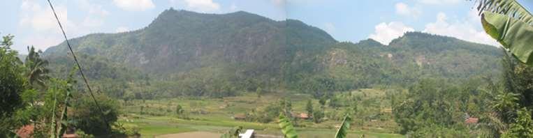
7 USLE methode was used to assess erosion risk USLE Formula: A = R x K x LS x C x P where: A : represents the potential long term average annual soil loss in tons per hectare (ton/ha/yr); R : rainfall runoff erosivity factor (mm/yr ); K : soil erodibility factor (ton/ha); LS : slope length steepness factor (dimensionless); C : crop management factor (dimensionless); P : is the land management practice factor (dimensionless).

8 USLE methode was used to assess erosion risk Rainfall Index EI 30 is defined as the product of kinetic energy of rainfall and the maximum contiguous 30 minutes rainfall intensity during the rainfall event EI 30 year = 0,41 x R 1,09 (Wiersum and Ambar 1979; in Ambar; 1986)


9 Soil erodibility index (K) No Soil Texture K 1. Clay 0,02 2. Loam clay 0,04 3. Loam sand 0,30 4. Sillty 0,20 5. Sandy 0,70 Crop- and vegetation cover index (CP) (Ministry of Forestry, 1985) No Class name CP 1. Settlement 0,60 2. Mixed Garden 0,30 3. Paddy Field 0,05 4. Dry fields 0,75 5. Garden 0,40 6. Forest 0,03
 x Pow ( 22.1 x 0.6 0.")
10 Slope gradient and Slope Length Index (LS) (Ministry of Forestry 1986) No Slope (%) LS , , , ,50 5. > 50 12,0 LS = Pow( FlowAcc x resolution sin slope gradient x ) x Pow ( 22.1 x x 1.3 )
11 STUDY RESULT Classification of erosion risk level (Ministry of Forestry 1998) No Soil loss Class of (ton/ha/th) Erosion Erosion Level 1. < 20 I Very low II Low III Moderate IV High 5. > 1000 V Very high

12 STUDY RESULT
13 Points of Field Survey No. Lat Long Location Geology Slope Ero Cilabodas Village Breksi/Andesit 54º Ero CicangkapGirang Tuffa, Sand 65º Ero Tugu Batas Sand 40º Ero M. Masigit Andesit 45º Ero BojongHaur Tuffa 36º Ero Sodong Village Tuffa 43º Ero Saguling Waterbody Tuffa, Sand 60º Ero Saguling Waterbody Tuffa, Sand 60º Ero Saguling Waterbody Tuffa, Sand 60º


14 Erosion in the roadside Village Saguling, Kec. Cipongkor Massive landslides in the roadside Cipongkor-Saguling
15 Conclusions Spatial modeling with GIS is capable to give a visual impression of the main factors contributing to soil erosion Most of the surroundings of Cipongkor is dominated by very high soil erosion potential. Human activity is one of the main factors affecting erosion potential in the study area. Increasing soil erosion and haphazard human interventions leading to destabilized slopes do aggravate the potential for damaging large scale landslide events.

16
Soil Erosion Calculation using Remote Sensing and GIS in Río Grande de Arecibo Watershed, Puerto Rico
 Soil Erosion Calculation using Remote Sensing and GIS in Río Grande de Arecibo Watershed, Puerto Rico Alejandra M. Rojas González Department of Civil Engineering University of Puerto Rico at Mayaguez.
GIS modelling based on slope and morphology for landslide potential area in Wonosobo, Central Java
 GIS modelling based on slope and morphology for landslide potential area in Wonosobo, Central Java Muhammad Chaidir Harist 1,*, Humam A. Afif 1, Dian Nurahandayani Putri 1, Iqbal Putut Ash Shidiq 1 1 Geography,
Review Using the Geographical Information System and Remote Sensing Techniques for Soil Erosion Assessment
 Polish J. of Environ. Stud. Vol. 19, No. 5 (2010), 881-886 Review Using the Geographical Information System and Remote Sensing Techniques for Soil Erosion Assessment Nuket Benzer* Landscape Architecture
INTERNATIONAL JOURNAL OF GEOMATICS AND GEOSCIENCES Volume 1, No 1, 2010
 An Integrated Approach with GIS and Remote Sensing Technique for Landslide Hazard Zonation S.Evany Nithya 1 P. Rajesh Prasanna 2 1. Lecturer, 2. Assistant Professor Department of Civil Engineering, Anna
Classification of Erosion Susceptibility
 GEO327G: GIS & GPS Applications in Earth Sciences Classification of Erosion Susceptibility Denali National Park, Alaska Zehao Xue 12 3 2015 2 TABLE OF CONTENTS 1 Abstract... 3 2 Introduction... 3 2.1 Universal
Comparison of Geomatics Approach and Mathematical Model in Assessment of Soil Erosion Prone Areas Kolli Hills, Namakkal District Tamilnadu, India
 Cloud Publications International Journal of Advanced Earth Science and Engineering 2013, Volume 2, Issue 1, pp. 43-56, Article ID Sci-20 Research Article Open Access Comparison of Geomatics Approach and
GIS model & modeling
 GIS model & modeling Model : a simplified representation of a phenomenon or a system. GIS modeling : the use of GIS in the process of building models with spatial data. Basic requirement in modeling :
Food Security Monitoring Bulletin. INDONESIA Special Focus: Estimating Impact of Disasters on Market Access
 Food Security Monitoring Bulletin INDONESIA Special Focus: Estimating Impact of Disasters on Market Access Volume 10, May 2018 CLIMATE AND FOOD SECURITY January - April 2018 More floods and landslides
Need of Proper Development in Hilly Urban Areas to Avoid
 Need of Proper Development in Hilly Urban Areas to Avoid Landslide Hazard Dr. Arvind Phukan, P.E. Cosultant/Former Professor of Civil Engineering University of Alaska, Anchorage, USA RI District Governor
Physical Geography: Patterns, Processes, and Interactions, Grade 11, University/College Expectations
 Geographic Foundations: Space and Systems SSV.01 explain major theories of the origin and internal structure of the earth; Page 1 SSV.02 demonstrate an understanding of the principal features of the earth
Gully erosion and associated risks in the Tutova basin Moldavian Plateau
 Landform Analysis, Vol. 17: 193 197 (2011) Gully erosion and associated risks in the Tutova basin Moldavian Plateau University Alexandru Ioan Cuza of Iasi, Department of Geography, Romania, e-mail: catiul@yahoo.com
DROUGHT RISK EVALUATION USING REMOTE SENSING AND GIS : A CASE STUDY IN LOP BURI PROVINCE
 DROUGHT RISK EVALUATION USING REMOTE SENSING AND GIS : A CASE STUDY IN LOP BURI PROVINCE K. Prathumchai, Kiyoshi Honda, Kaew Nualchawee Asian Centre for Research on Remote Sensing STAR Program, Asian Institute
International Journal of Science and Engineering (IJSE)
") Internat. J. Sci. Eng., Vol. 6(1)2014:56-60, January 2014, Ahmad Rifqi Asrib et al. International Journal of Science and Engineering (IJSE) Home page: http://ejournal.undip.ac.id/index.php/ijse Analysis
Internat. J. Sci. Eng., Vol. 6(1)2014:56-60, January 2014, Ahmad Rifqi Asrib et al. International Journal of Science and Engineering (IJSE) Home page: http://ejournal.undip.ac.id/index.php/ijse Analysis
Droughts are normal recurring climatic phenomena that vary in space, time, and intensity. They may affect people and agriculture at local scales for
 I. INTRODUCTION 1.1. Background Droughts are normal recurring climatic phenomena that vary in space, time, and intensity. They may affect people and agriculture at local scales for short periods or cover
Landslide Susceptibility Mapping Using Logistic Regression in Garut District, West Java, Indonesia
 Landslide Susceptibility Mapping Using Logistic Regression in Garut District, West Java, Indonesia N. Lakmal Deshapriya 1, Udhi Catur Nugroho 2, Sesa Wiguna 3, Manzul Hazarika 1, Lal Samarakoon 1 1 Geoinformatics
Modeling Surface Runoff Path and Soil Erosion in Catchment Area of Hanp River of District Kabeerdham, CG, INDIA, Using GIS
 International Journal of Scientific and Research Publications, Volume 6, Issue 5, May 2016 645 Modeling Surface Runoff Path and Soil Erosion in Catchment Area of Hanp River of District Kabeerdham, CG,
COMMON GIS TECHNIQUES FOR VECTOR AND RASTER DATA PROCESSING. Ophelia Wang, Department of Geography and the Environment, University of Texas
 COMMON GIS TECHNIQUES FOR VECTOR AND RASTER DATA PROCESSING Ophelia Wang, Department of Geography and the Environment, University of Texas PART I: BASIC VECTOR TOOLS CLIP A FEATURE BASED ON THE EXTENT
Use of Geospatial data for disaster managements
 Use of Geospatial data for disaster managements Source: http://alertsystemsgroup.com Instructor : Professor Dr. Yuji Murayama Teaching Assistant : Manjula Ranagalage What is GIS? A powerful set of tools
Potential Impacts of Climate Change on Soil Erosion Vulnerability Across the Conterminous U.S.
 Potential Impacts of Climate Change on Soil Erosion Vulnerability Across the Conterminous U.S. Catalina Segura 1, Ge Sun 2, Steve McNulty 2, and Yang Zhang 1 1 2 1 Soil Erosion Natural process by which
RESEARCH METHODOLOGY
 III. RESEARCH METHODOLOGY 3.1. Time and Research Area The field work was taken place in primary forest around Toro village in Lore Lindu National Park, Indonesia. The study area located in 120 o 2 53 120
Erosion Susceptibility in the area Around the Okanogan Fire Complex, Washington, US
 Erosion Susceptibility in the area Around the Okanogan Fire Complex, Washington, US 1. Problem Construct a raster that represents susceptibility to erosion based on lithology, slope, cover type, burned
UNIVERSITY OF CAMBRIDGE INTERNATIONAL EXAMINATIONS International General Certificate of Secondary Education
 www.xtremepapers.com UNIVERSITY OF CAMBRIDGE INTERNATIONAL EXAMINATIONS International General Certificate of Secondary Education *3624174963* ENVIRONMENTAL MANAGEMENT 0680/21 Paper 2 May/June 2013 1 hour
Soil erosion susceptibility and coastal evolution: examples in southern New Caledonia
 Pacific Island Countries GIS /RS User Conference Soil erosion susceptibility and coastal evolution: examples in southern New Caledonia Pascal DUMAS et Olivier COHEN University of New-Caledonia (EA 4242/
Assessment of solid load and siltation potential of dams reservoirs in the High Atlas of Marrakech (Moorcco) using SWAT Model
 using SWAT Model") Assessment of solid load and siltation potential of dams reservoirs in the High Atlas of Marrakech (Moorcco) using SWAT Model Amal Markhi: Phd Student Supervisor: Pr :N.Laftrouhi Contextualization Facing
Assessment of solid load and siltation potential of dams reservoirs in the High Atlas of Marrakech (Moorcco) using SWAT Model Amal Markhi: Phd Student Supervisor: Pr :N.Laftrouhi Contextualization Facing
Landslide analysis to estimate probability occurrence of earthquakes by software ArcGIS in central of Iran
 Research Journal of Recent Sciences ISSN 2277-2502 Res.J.Recent Sci. Landslide analysis to estimate probability occurrence of earthquakes by software ArcGIS in central of Iran Abstract Hamid Reza Samadi
INTERNATIONAL JOURNAL OF GEOMATICS AND GEOSCIENCES Volume 4, No 2, 2013
 INTERNATIONAL JOURNAL OF GEOMATICS AND GEOSCIENCES Volume 4, No 2, 2013 Copyright 2010 All rights reserved Integrated Publishing services Research article ISSN 0976 4380 Evaluation of landuse / landcover
What Is Water Erosion? Aren t they the same thing? What Is Sediment? What Is Sedimentation? How can Sediment Yields be Minimized?
 Jerald S. Fifield, Ph.D. CISEC HydroDynamics Incorporated Parker, CO 303-841-0377 Aren t they the same thing? What Is Sediment? Soil particles deposited or suspended in water or air The process of depositing
LANDSLIDE SUSCEPTIBILITY MAPPING USING INFO VALUE METHOD BASED ON GIS
 LANDSLIDE SUSCEPTIBILITY MAPPING USING INFO VALUE METHOD BASED ON GIS ABSTRACT 1 Sonia Sharma, 2 Mitali Gupta and 3 Robin Mahajan 1,2,3 Assistant Professor, AP Goyal Shimla University Email: sonia23790@gmail.com
River bank erosion risk potential with regards to soil erodibility
 River Basin Management VII 289 River bank erosion risk potential with regards to soil erodibility Z. A. Roslan 1, Y. Naimah 1 & Z. A. Roseli 2 1 Infrastructure University, Kuala Lumpur, Malaysia 2 Humid
Result of Field Geological Survey and Ground Truth for the Analysis Date: 2007/7/5 Location (UTM) Elev Geological Unit Point No. NT-02 VSW Index 260,7
 Elev Geological Unit Point No. NT-02 VSW Index 260,7") Date: Point No. 2007/7/5 NT-01 Result of Field Geological Survey and Ground Truth for the Analysis Location (UTM) Topography of granite hill in flat land Lithology: Medium grained hornblende granite. Topography:
Date: Point No. 2007/7/5 NT-01 Result of Field Geological Survey and Ground Truth for the Analysis Location (UTM) Topography of granite hill in flat land Lithology: Medium grained hornblende granite. Topography:
Sediment- yield estimation, by M-PSIAC method in a GIS environment, case study:jonaghn river sub basin(karun basin)
") Sediment- yield estimation, by M-PSIAC method in a GIS environment, case study:jonaghn river sub basin(karun basin) Yavari-shahla *,Khdabakhsh-Saeed,Mohseni-Hasan, Rezai- Khalil Corresponding author: a
Sediment- yield estimation, by M-PSIAC method in a GIS environment, case study:jonaghn river sub basin(karun basin) Yavari-shahla *,Khdabakhsh-Saeed,Mohseni-Hasan, Rezai- Khalil Corresponding author: a
Georeferencing and Satellite Image Support: Lessons learned, Challenges and Opportunities
 Georeferencing and Satellite Image Support: Lessons learned, Challenges and Opportunities Shirish Ravan shirish.ravan@unoosa.org UN-SPIDER United Nations Office for Outer Space Affairs (UNOOSA) UN-SPIDER
Application of SWAT Model to Estimate the Runoff and Sediment Load from the Right Bank Valleys of Mosul Dam Reservoir
 Application of SWAT Model to Estimate the Runoff and Sediment Load from the Right Bank Valleys of Mosul Dam Reservoir Dr Mohammad Ezeel Deen Prof. Nadhir Al-Ansari Prof Sven Knutsson Figure 1.Map of Iraq
Slope Stability Zonation Map of the Citanduy River Catchment Area, West Java, Indonesia. Irvan Sophian* and Dicky Muslim* Abstract
 Slope Stability Zonation Map of the Citanduy River Catchment Area, West Java, Indonesia Irvan Sophian* and Dicky Muslim* Abstract In Indonesia, West Java Province is well known for the most frequent landslide
GIS APPLICATION ON GEOLOGICAL CHARACTERISTICS AS THE PREDICTINGFOR SOIL EROSION IN KHAEW NOI WATERSHED, PHITSANULOK PROVINCE
 GIS APPLICATION ON GEOLOGICAL CHARACTERISTICS AS THE PREDICTINGFOR SOIL EROSION IN KHAEW NOI WATERSHED, PHITSANULOK PROVINCE Vicharn AMARAKUL Lecturer, Faculty of Agriculture, Natural Resources and Environment
2014 Summer Training Courses on Slope Land Disaster Reduction Hydrotech Research Institute, National Taiwan University, Taiwan August 04-15, 2014
 Final Project Report 2014 Summer Training Courses on Slope Land Disaster Reduction Hydrotech Research Institute, National Taiwan University, Taiwan August 04-15, 2014 Landslides in Mt. Umyeon Susceptibility
Eagle Creek Post Fire Erosion Hazard Analysis Using the WEPP Model. John Rogers & Lauren McKinney
 Eagle Creek Post Fire Erosion Hazard Analysis Using the WEPP Model John Rogers & Lauren McKinney Columbia River Gorge at Risk: Using LiDAR and GIS-based predictive modeling for regional-scale erosion susceptibility
Effect of land cover / use change on soil erosion assessment in Dubračina catchment (Croatia)
") European Water 57: 171-177, 2017. 2017 E.W. Publications Effect of land cover / use change on soil erosion assessment in Dubračina catchment (Croatia) N. Dragičević *, B. Karleuša and N. Ožanić Faculty
European Water 57: 171-177, 2017. 2017 E.W. Publications Effect of land cover / use change on soil erosion assessment in Dubračina catchment (Croatia) N. Dragičević *, B. Karleuša and N. Ožanić Faculty
LANLDSIDE HAZARD, SOCIAL-ECONOMIC VULNERABILITY AND PHYSICAL (BUILDINGS) RISK ASSESMENT SAGAREJO MUNICIPALITY CASE STUDY (PROJECT)
 RISK ASSESMENT SAGAREJO MUNICIPALITY CASE STUDY (PROJECT)") LANLDSIDE HAZARD, SOCIAL-ECONOMIC VULNERABILITY AND PHYSICAL (BUILDINGS) RISK ASSESMENT SAGAREJO MUNICIPALITY CASE STUDY (PROJECT) - 1 - 1. INTRODUCTION 3 2. USED DATA 4 3. METHODOLOGY 5 3.1 Work flow
LANLDSIDE HAZARD, SOCIAL-ECONOMIC VULNERABILITY AND PHYSICAL (BUILDINGS) RISK ASSESMENT SAGAREJO MUNICIPALITY CASE STUDY (PROJECT) - 1 - 1. INTRODUCTION 3 2. USED DATA 4 3. METHODOLOGY 5 3.1 Work flow
DAMAGE DETECTION OF THE 2008 SICHUAN, CHINA EARTHQUAKE FROM ALOS OPTICAL IMAGES
 DAMAGE DETECTION OF THE 2008 SICHUAN, CHINA EARTHQUAKE FROM ALOS OPTICAL IMAGES Wen Liu, Fumio Yamazaki Department of Urban Environment Systems, Graduate School of Engineering, Chiba University, 1-33,
INTRODUCTION TO ARCGIS 10
 Department of Irrigation, Drainage and Landscape Engineering, Faculty of Civil Engineering, CTU Prague Institute of Hydraulics and Rural Water Management BOKU Vienna INTRODUCTION TO ARCGIS 10 MAIN WINDOW
Michael Barton School of Human Evolution & Social Change Center for Social Dynamics & Complexity
 Michael Barton School of Human Evolution & Social Change Center for Social Dynamics & Complexity Social Systems are Complex Even simple social systems are complex Complexity has grown at increasing rate
Alaska, USA. Sam Robbins
 Using ArcGIS to determine erosion susceptibility within Denali National Park, Alaska, USA Sam Robbins Introduction Denali National Park is six million acres of wild land with only one road and one road
Impact : Changes to Existing Topography (Less than Significant)
") 4.2 Land Resources 4.2.1 Alternative A Proposed Action Impact 4.2.1-1: Changes to Existing Topography (Less than Significant) Development of the project site would involve grading and other earthwork as
4.2 Land Resources 4.2.1 Alternative A Proposed Action Impact 4.2.1-1: Changes to Existing Topography (Less than Significant) Development of the project site would involve grading and other earthwork as
Delineation of Groundwater Potential Zone on Brantas Groundwater Basin
 Delineation of Groundwater Potential Zone on Brantas Groundwater Basin Andi Rachman Putra 1, Ali Masduqi 2 1,2 Departement of Environmental Engineering, Sepuluh Nopember Institute of Technology, Indonesia
The relationship between drainage density and soil erosion rate: a study of five watersheds in Ardebil Province, Iran
 River Basin Management VIII 129 The relationship between drainage density and soil erosion rate: a study of five watersheds in Ardebil Province, Iran A. Moeini 1, N. K. Zarandi 1, E. Pazira 1 & Y. Badiollahi
Multicriteria GIS Modelling of Terrain Susceptibility to Gully Erosion, using the Example of the Island of Pag
 14th International Conference on Geoinformation and Cartography Zagreb, September 27-29, 2018. Multicriteria GIS Modelling of Terrain Susceptibility to Gully Erosion, using the Example of the Island of
Int.J.Curr.Microbiol.App.Sci (2017) 6(8):
 6(8):") International Journal of Current Microbiology and Applied Sciences ISSN: 2319-7706 Volume 6 Number 8 (2017) pp. 314-331 Journal homepage: http://www.ijcmas.com Original Research Article https://doi.org/10.20546/ijcmas.2017.608.042
International Journal of Current Microbiology and Applied Sciences ISSN: 2319-7706 Volume 6 Number 8 (2017) pp. 314-331 Journal homepage: http://www.ijcmas.com Original Research Article https://doi.org/10.20546/ijcmas.2017.608.042
Maria Antonia Brovelli
 Managing Satellite Precipitation Data (PERSIANN) Through Web GeoServices: A Case Study in North Vietnam Presenter: Maria Antonia Brovelli Truong Xuan Quang DIIAR, Politecnico di Milano Como Campus, Italy
Geospatial Approach for Delineation of Landslide Susceptible Areas in Karnaprayag, Chamoli district, Uttrakhand, India
 Geospatial Approach for Delineation of Landslide Susceptible Areas in Karnaprayag, Chamoli district, Uttrakhand, India Ajay Kumar Sharma & Anand Mohan Singh Overview Landslide - movement of a mass of rock,
Abdolreza Ansari Amoli. Remote Sensing Department Iranian Space Agency
 Risk Assessment and Mapping Using Earth Observation Data In Iran Abdolreza Ansari Amoli Remote Sensing & GIS Expert Remote Sensing Department Iranian Space Agency Different Types of Disasters in Iran Epidemic
Debris flow: categories, characteristics, hazard assessment, mitigation measures. Hariklia D. SKILODIMOU, George D. BATHRELLOS
 Debris flow: categories, characteristics, hazard assessment, mitigation measures Hariklia D. SKILODIMOU, George D. BATHRELLOS Natural hazards: physical phenomena, active in geological time capable of producing
Virtual Reality Modeling of Landslide for Alerting in Chiang Rai Area Banphot Nobaew 1 and Worasak Reangsirarak 2
 Virtual Reality Modeling of Landslide for Alerting in Chiang Rai Area Banphot Nobaew 1 and Worasak Reangsirarak 2 1 Banphot Nobaew MFU, Chiang Rai, Thailand 2 Worasak Reangsirarak MFU, Chiang Rai, Thailand
International Journal of Scientific Research and Reviews
 Case Study Available online www.ijsrr.org ISSN: 2279 0543 International Journal of Scientific Research and Reviews Study on the Pattern of Land Use /Land Cover Change in Sonipat District of NCR, A Block
Investigation of the 2013 Hadari Debris Flow in Korea Through Field Survey and Numerical Analysis
 Investigation of the 2013 Hadari Debris Flow in Korea Through Field Survey and Numerical Analysis Junghae Choi * Department of Earth Science Education, Kyungpook National University, Korea, Assistant Professor
Vulnerability assessment of Sta.Rosa-Silang subwatershed using SWAT
 Vulnerability assessment of Sta.Rosa-Silang subwatershed using SWAT Damasa B. Magcale-Macandog, Charles Gunay and Milben A. Bragais Institute of Biological Sciences, University of the Philippines Los Baños,
One Map Policy to Support National Development in Indonesia
 One Map Policy to Support National Development in Indonesia Dr. Nurwadjedi Sarbini Deputy of Thematic Geospatial Information Geospatial Information Agency (BIG) Geosmart Asia, September 29 October 1, 2015
Evaluation of the SWAT Model Setup Process Through A Case Study in Roxo Catchment, Portugal
 Evaluation of the SWAT Model Setup Process Through A Case Study in Roxo Catchment, Portugal Mustafa Gökmen Master Degree in on Geo-information and Earth Observation for Integrated Catchment and Water Resources
1. Introduction. 2. Study area. Arun Babu Elangovan 1+ and Ravichandran Seetharaman 2
 2011 International Conference on Environmental and Computer Science IPCBEE vol.19(2011) (2011) IACSIT Press, Singapore Estimating Rainfall Erosivity of the Revised Universal Soil Loss Equation from daily
Surface Processes Focus on Mass Wasting (Chapter 10)
") Surface Processes Focus on Mass Wasting (Chapter 10) 1. What is the distinction between weathering, mass wasting, and erosion? 2. What is the controlling force in mass wasting? What force provides resistance?
Surface Processes Focus on Mass Wasting (Chapter 10) 1. What is the distinction between weathering, mass wasting, and erosion? 2. What is the controlling force in mass wasting? What force provides resistance?
Inspection Procedure of Steep Slope Failure Hazard Area, etc.
 Inspection Procedure of Steep Slope Failure Hazard Area, etc. November, 1999 Slope Conservation Division, Sabo Department, Ministry of Construction Inspection Procedure of Steep Slope Failure Hazard Area,
SEDIMENT YIELD ESTIMATION AND PRIORITIZATION OF WATERSHED USING REMOTE SENSING AND GIS
 SEDIMENT YIELD ESTIMATION AND PRIORITIZATION OF WATERSHED USING REMOTE SENSING AND GIS Sreenivasulu Vemu, Udaya Bhaskar Pinnamaneni Department of Civil Engineering, JNT University, Kakinada, Andhra Pradesh,
PALEOGEOGRAPHY of NYS. Definitions GEOLOGIC PROCESSES. Faulting. Folding 9/6/2012. TOPOGRAPHIC RELIEF MAP of NYS GRADATIONAL TECTONIC
 TOPOGRAPHIC RELIEF MAP of NYS PALEOGEOGRAPHY of NYS Prof. Anthony Grande AFG 2012 Definitions GEOLOGIC PROCESSES Geography: study of people living on the surface of the earth. Geology: the scientific study
ESTIMATING AND MAPPING TORRENTIALITY RISK IN SMALL FORESTED WATERSHEDS
 Bulletin of the Transilvania University of Braşov Series II: Forestry Wood Industry Agricultural Food Engineering Vol. 4 (53) No. 1-2011 ESTIMATING AND MAPPING TORRENTIALITY RISK IN SMALL FORESTED WATERSHEDS
Landuse and Landcover change analysis in Selaiyur village, Tambaram taluk, Chennai
 Landuse and Landcover change analysis in Selaiyur village, Tambaram taluk, Chennai K. Ilayaraja Department of Civil Engineering BIST, Bharath University Selaiyur, Chennai 73 ABSTRACT The synoptic picture
International Journal of Scientific & Engineering Research, Volume 6, Issue 7, July ISSN
 International Journal of Scientific & Engineering Research, Volume 6, Issue 7, July-2015 1428 Accuracy Assessment of Land Cover /Land Use Mapping Using Medium Resolution Satellite Imagery Paliwal M.C &.
Module/Unit: Landforms Grade Level: Fifth
 Module/Unit: Landforms Grade Level: Fifth PA Academic Standards for Science and Technology and Environment and Ecology: 3.1.7.B Describe the use of models as an application or scientific or technological
Effect of land use/land cover changes on runoff in a river basin: a case study
 Water Resources Management VI 139 Effect of land use/land cover changes on runoff in a river basin: a case study J. Letha, B. Thulasidharan Nair & B. Amruth Chand College of Engineering, Trivandrum, Kerala,
AN APPROACH TO THE CLASSIFICATION OF SLOPE MOVEMENTS
 Training/workshop on Earthquake Vulnerability and Multi-Hazard Risk Assessment: Geospatial Tools for Rehabilitation and Reconstruction Effort 13 31 March 2006, Islamabad, Pakistan AN APPROACH TO THE CLASSIFICATION
Landslide Hazard Investigation in Papua New Guinea-A Remote Sensing & GIS Approach
 Landslide Hazard Investigation in Papua New Guinea-A Remote Sensing & GIS Approach Sujoy Kumar Jana 1, Tingneyuc Sekac 2, Dilip Kumar Pal 3 Abstract: Tribal communities living in the mountainous regions
2013 Esri Europe, Middle East and Africa User Conference October 23-25, 2013 Munich, Germany
 2013 Esri Europe, Middle East and Africa User Conference October 23-25, 2013 Munich, Germany Environmental and Disaster Management System in the Valles Altos Region in Carabobo / NW-Venezuela Prof.Dr.habil.Barbara
Existing NWS Flash Flood Guidance
 Introduction The Flash Flood Potential Index (FFPI) incorporates physiographic characteristics of an individual drainage basin to determine its hydrologic response. In flash flood situations, the hydrologic
Weathering is the process that breaks down rock and other substances at Earth s surface
 Chapter 8 Notes Weathering is the process that breaks down rock and other substances at Earth s surface Factors that contribute to weathering Heat Cold Water Ice O 2 & CO 2 in the atmosphere Examples of
The future of the Lowland Belizean Savannas?.
 The future of the Lowland Belizean Savannas?. Using cluster analysis to explore multivariate spatial patterns in savanna soils PETER FURLEY & SARAH BEADLE UK Belize association 15 th November 2014 Outline
Yaneev Golombek, GISP. Merrick/McLaughlin. ESRI International User. July 9, Engineering Architecture Design-Build Surveying GeoSpatial Solutions
 Yaneev Golombek, GISP GIS July Presentation 9, 2013 for Merrick/McLaughlin Conference Water ESRI International User July 9, 2013 Engineering Architecture Design-Build Surveying GeoSpatial Solutions Purpose
3. SITE CHARACTERISATION AND FIELD OBSERVATIONS
 Page 13 3. SITE CHARACTERISATION AND FIELD OBSERVATIONS 3.1. Geology 3.1.1. Structural Geology Unlike most islands of the Lesser Antilles, Trinidad is of sedimentary origin, rather than volcanic composition.
Environmental Change Analysis in Nias Island Using Remote Sensing Technique
 IJCST Vo l. 8, Is s u e 2, Ap r i l - Ju n e 2017 ISSN : 0976-8491 (Online) ISSN : 2229-4333 (Print) Environmental Change Analysis in Nias Island Using Remote Sensing Technique 1 Togi Tampubolon, 2 Rita
Chapter 2. Regional Landscapes and the Hydrologic Cycle
 Chapter 2. Regional Landscapes and the Hydrologic Cycle W. Lee Daniels Department of Crop and Soil Environmental Sciences, Virginia Tech Table of Contents Introduction... 23 Soils and landscapes of the
Ganbat.B, Agro meteorology Section
 NATIONAL AGENCY FOR METEOROLOGY, HYDROLOGY AND ENVIRONMENT MONITORING OF MONGOLIA Ganbat.B, Agro meteorology Section OF INSTITUTE OF METEOROLOGY AND HYDROLOGY 2009 YEAR Location Climate Northern Asia,
Analysis of Land Use And Land Cover Changes Using Gis, Rs And Determination of Deforestation Factors Using Unsupervised Classification And Clustering
 IOSR Journal of Applied Geology and Geophysics (IOSR-JAGG) e-issn: 2321 0990, p-issn: 2321 0982.Volume 5, Issue 3 Ver. II (May - June 2017), PP 73-78 www.iosrjournals.org Analysis of Land Use And Land
Vulnerability mapping for sustainable hazard mitigation in the city of Bukavu, South Kivu DRCongo
 IAG/AIG REGIONAL CONFERENCE, 18th to 22nd Feb. 2011 Vulnerability mapping for sustainable hazard mitigation in the city of Bukavu, South Kivu DRCongo Sadiki Ndyanabo 1, Ine Vandecasteele 2, Jan Moeyersons
LOCAL PERCEPTION OF LANDSLIDE PROBLEMS IN MANJIYA COUNTY, MBALE DISTRICT, EASTERN UGANDA
 MOUNTAIN ECOSYSTEMS, RESOURCES AND DEVELOPMENT IN UGANDA, A PUBLICATION OF MOUNTAIN RESOURCE CENTRE, DEPARTMENT OF GEOGRAPHY, MAKERERE UNIVERSITY, (2004), PAGES 94-98. ISBN 9970-05-017-6. LOCAL PERCEPTION
VENETO REGION PILOT AREA
 VENETO REGION PILOT AREA The pilot area is located in the north-east of Veneto region, located itself in the north-east of Italy. The area borders with Austria are in the northern part and run along high
PUSAT PENELlTlAN LINGKUNGAN HlDUP CENTER FOR ENVIRONMENTAL RESEARCH INSTITUT PERTANIAN BOGOR
 PUSAT PENELlTlAN LINGKUNGAN HlDUP CENTER FOR ENVIRONMENTAL RESEARCH INSTITUT PERTANIAN BOGOR Working Paper No. 13 September 2009 The Analysis of the Landcover Change Effect to Soil Erosion Using Spatial
Geo-Environmental Study of Kaliasaur Landslide in District Rudraprayag of Garhwal Himalaya, Uttarakhand, India
 International Journal of Humanities and Social Science Invention ISSN (Online): 2319 7722, ISSN (Print): 2319 7714 Volume 5 Issue 3 March. 2016 PP.07-13 Geo-Environmental Study of Kaliasaur Landslide in
FOREST FIRE HAZARD MODEL DEFINITION FOR LOCAL LAND USE (TUSCANY REGION)
") FOREST FIRE HAZARD MODEL DEFINITION FOR LOCAL LAND USE (TUSCANY REGION) C. Conese 3, L. Bonora 1, M. Romani 1, E. Checcacci 1 and E. Tesi 2 1 National Research Council - Institute of Biometeorology (CNR-
FOREST FIRE HAZARD MODEL DEFINITION FOR LOCAL LAND USE (TUSCANY REGION) C. Conese 3, L. Bonora 1, M. Romani 1, E. Checcacci 1 and E. Tesi 2 1 National Research Council - Institute of Biometeorology (CNR-
CHANGE DETECTION USING REMOTE SENSING- LAND COVER CHANGE ANALYSIS OF THE TEBA CATCHMENT IN SPAIN (A CASE STUDY)
") CHANGE DETECTION USING REMOTE SENSING- LAND COVER CHANGE ANALYSIS OF THE TEBA CATCHMENT IN SPAIN (A CASE STUDY) Sharda Singh, Professor & Programme Director CENTRE FOR GEO-INFORMATICS RESEARCH AND TRAINING
CHANGE DETECTION USING REMOTE SENSING- LAND COVER CHANGE ANALYSIS OF THE TEBA CATCHMENT IN SPAIN (A CASE STUDY) Sharda Singh, Professor & Programme Director CENTRE FOR GEO-INFORMATICS RESEARCH AND TRAINING
Hydrologic Modelling of the Upper Malaprabha Catchment using ArcView SWAT
 Hydrologic Modelling of the Upper Malaprabha Catchment using ArcView SWAT Technical briefs are short summaries of the models used in the project aimed at nontechnical readers. The aim of the PES India
Weathering and Soil Formation. Chapter 10
 Weathering and Soil Formation Chapter 10 Old and New Mountains The Appalachian Mountains appear very different from the Sierra Mountains. The Appalachians are smaller, rounded, gently sloping, and covered
Coalfields Limited. Based on Satellite Data for the Year Central Coalfields Limited Ranchi, Jharkhand. Submitted to:
 Land Restoration / Reclamation Monitoring of less than 5 m cu. m. (Coal + OB) Capacity Open Cast Coal Mines of Central Coalfields Limited Based on Satellite Data for the Year 2011. N URIMARI (BIRSA) OCP,CCL
Watershed Processes and Modeling
 Watershed Processes and Modeling Pierre Y. Julien Hyeonsik Kim Department of Civil Engineering Colorado State University Fort Collins, Colorado Kuala Lumpur - May Objectives Brief overview of Watershed
Landslide Susceptibility Model of Tualatin Mountains, Portland Oregon. By Tim Cassese and Colby Lawrence December 10, 2015
 Landslide Susceptibility Model of Tualatin Mountains, Portland Oregon By Tim Cassese and Colby Lawrence December 10, 2015 Landslide Closes Highway 30 at St. John's Bridge Introduction: Study Area: Tualatin
Special edition paper
 Development of a System for Natural Disaster Risk Factor Evaluation by the EADaS Method Ryuji Oshima* Asako Togari* Masahiko Tomori* Natural disasters of a variety of scales occur along railway lines,
WORKING DRAFT List of Figures Groundwater Sustainability Plan for Santa Rosa Plain Subbasin. Figure Number. Figure Title
 . WORKING DRAFT List of s Grodwater Sustainability Plan for Subbasin Number Title Plan Area Section 2-1 Plan Area 2-2 Elevation and Surface Water Features 2-3 Jurisdictional and Protected Areas 2-4a Historical
INTRODUCTION Water resources are vitally important for the future of humankind. Groundwater from karst aquifers is among the most important drinking w
 Vulnerability Mapping for the Protection of Carbonate (Karst) Aquifers (Ramallah-Al Bireh District) Eng. Amjad da Assi House of fw Water and de Environment May, 2007 INTRODUCTION Water resources are vitally
Land capability and Crop Suitability using RS and GIS
 International Journal of Technical & Scientific Research Engineering Volume 1 Issue 2, July-August 2018 www.ijtsre.org Anjan Kumar 1, Ravikumar A.S 2 1 (PG student, Water Resource Engg, Dept. of Civil
Geospatial Data Mining to Explore Watershed Development in Rainfed Regions
 Geospatial Data Mining to Explore Watershed Development in Rainfed Regions S. Nallan 1, L. Armstrong 1, Andreas Neuhaus 1,2, B. Croke 3, N. Dunstan 1,4 1 School of Computer and Security Science, Edith
Watershed Classification with GIS as an Instrument of Conflict Management in Tropical Highlands of the Lower Mekong Basin
 Page 1 of 8 Watershed Classification with GIS as an Instrument of Conflict Management in Tropical Highlands of the Lower Mekong Basin Project Abstract The University of Giessen is actually planning a research
Rocks and Weathering
 Rocks and Weathering The Effects of Weathering The process of mountain building thrusts rock up to Earth s surface. Weathering is the process that breaks down rock and other substances at Earth s surface.
Which map shows the stream drainage pattern that most likely formed on the surface of this volcano? A) B)
 B)") 1. When snow cover on the land melts, the water will most likely become surface runoff if the land surface is A) frozen B) porous C) grass covered D) unconsolidated gravel Base your answers to questions
1. When snow cover on the land melts, the water will most likely become surface runoff if the land surface is A) frozen B) porous C) grass covered D) unconsolidated gravel Base your answers to questions