Carboniferous Stratigraphic Analysis in the Subandean Foothills and the Chaco Plains of Tarija Basin-Bolivia.
|
|
|
- Trevor Powell
- 5 years ago
- Views:
Transcription
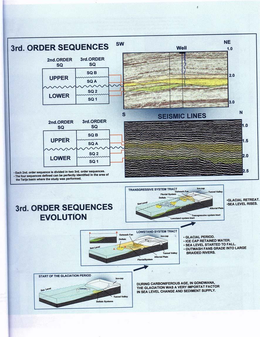
1 AAPG Convention, Denver 2001 Carboniferous Stratigraphic Analysis in the Subandean Foothills and the Chaco Plains of Tarija Basin-Bolivia. VIERA, ATILIO F., Pluspetrol E&P, Buenos Aires, Argentina; HERNANDEZ ROBERTO M., XR Exploracionistas, Salta, Argentina. According to well data, outcrops and 2D and 3D seismic information, a regional sequential stratigraphic analysis is developed for the Carboniferous Interval of the Southwest sector of the Tarija Basin. The area of study lies between Santa Cruz de la Sierra to the North, the Charagua, Aguarague and Parabanon ranges to the West, the Pilcomayo River to the South and the Chaco Plains to the East. (Figure 1). The Carboniferous depositional cycle lasts approximately 74 million years. Its deposits are influenced in part by glaciation. The distribution of the sedimentary infilling is directly related to the advance or retreat of the glaciers and to the eustatic variations and the accommodation space generated. The base of the Carboniferous is an important erosive unconformity generated on the Devonian age deposits corresponding to the Iquiri Fm. The top is an erosive unconformity showing a very important paleoclimatic change represented by Permian eolian sediments belonging to the Cangapi Frn. Based on seismic interpretation two Megasequences have been defined. The limit between them is a regional erosive unconformity characterized by the development of important paleovalleys. These paleovalleys indicate the major advance of the glaciar systems during the Carboniferous. It is assumed that this unconformity corresponds in age to the Mississippian Pennsylvanian limit. The lower Megasequence, of Mississippian age, shows marine influence by the association of facies defined in outcrops, especially in its early stage. For the Upper Megasequence, of Pennsylvanian age, continental environments prevail. Seismically interpreted, erosive limits allow the subdivision of these two Megasequences in two sequences of third-order respectively. (Figure 2). Each one of the four defined sequences (SSQI, SSQ2, SSQA and SSQB) is formed by deposits corresponding to the development of the Lowstand system tract and the Transgressive system tract. The basal section of each sequence comprises deposits of subaerial and subaqueous outwash and deltaic deposits, which are lithologically represented by diamictites, sandstones and shales eventually.
2 The top section of each sequence represents the infilling of these eroded paleovalleys plus the flood plain deposits. Lithologically these are represented by sandstones and shales. (Figure 3). Due to reworking of the top sediments of each one of the sequences the preservation potential of the transgressive system tract is low. However, in the area of the study those corresponding to SSQI and SSQB are preserved, and can be regionally correlated. In accordance with our work they would correspond to the maximum flooding surface during the Carboniferous, (SSQI), and to the flooding of the depositional system on reaching the equilibrium profile,(ssqb). The limits of each one of the sequences could be defined in outcrops and wells. Their geometry has been adjusted using seismic interpretation. The integration of these data enables us to determine the paleogeography of each one of the Sequences. Based on the result of this analysis the source for all the Carboniferous deposits could be seen to come from an Easterly or Southeasterly direction with the depocenter of the basin developed toward the North and Northwest of the study area. In general an increase in the shale content for each sequence can be observed as one moves in a North or Northwesterly direction. (Figure 4). The different cycles studied here have been matched to the classic stratigraphic units of the Tarija Basin. References Boulton G.S. 1990, Sedimentary and Sea level changes during glacial cycles and their control on glacimarine facies architecture. Dowdeswell, J.A. and Scourse, J.D. (eds), Glacimarine Environments: Processes and Sediments. Geological Society Special Publications Bennett M.R. and Glasser N.F Glacial Geology. Ice sheet and Landforms. Benn D.I. and Evans W.A Glaciers and Glaciation. Eyles N. y Eyles C.H., 1992 Glacial depositional Systems. Facies model Response to Sea-Level Change. Walker, R.G. and Jmaes N.P. (eds) Geological Association of Canadd, Toronto, Rocha Campos A.C., De Carvalho R.G., Amos A.J., 1977: A Carboniferous (Gondwana) fauna from Subandean Bolivia. Rev. Brasil. Geocien. 7(4): Trujillo-lkada H Nuevo hallazgo de fósiles de la Formación Taiguati en la serranía de Calpipendi, Santa Cruz, Bolivia. Revista Tecnica YPFB, v. 19(1-2):7-11. Cochabamba.

3

4

5
6

7

8

9
10

11

12
Depositional Sequences Sequences
 Depositional Sequences Transgressive and Regressive packages can be bound by unconformities Because sediment can only be preserved during net aggradation and progradation All other times there is either
Case Study of the Structural and Depositional-Evolution Interpretation from Seismic Data*
 Case Study of the Structural and Depositional-Evolution Interpretation from Seismic Data* Yun Ling 1, Xiangyu Guo 1, Jixiang Lin 1, and Desheng Sun 1 Search and Discovery Article #20143 (2012) Posted April
Sequence Stratigraphy: An Applied Workshop
 Sequence Stratigraphy: An Applied Workshop Instructor: Prof. Octavian Catuneanu Level: Intermediate Duration: 5 days Course Description and Objectives This workshop presents the concepts and practical
EUSTATIC AND TECTONIC CONTROL OF SEDIMENTATION IN THE PENNSYLVANIAN STRATA OF THE CENTRAL APPALACHIAN BASIN, USA
 Comptes Rendus XII ICC-P Volume 2:421-430 Buenos Aires, 1993 EUSTATIC AND TECTONIC CONTROL OF SEDIMENTATION IN THE PENNSYLVANIAN STRATA OF THE CENTRAL APPALACHIAN BASIN, USA Donald R. CHESNUT Jr. Kentucky
Accommodation. Tectonics (local to regional) Subsidence Uplift
 Subsidence Uplift") Accommodation Accommodation varies over time; it is the distance between a reference horizon and the sea surface (i.e. relative sea level). The space to be filled in with sediments or water What are the
Accommodation Accommodation varies over time; it is the distance between a reference horizon and the sea surface (i.e. relative sea level). The space to be filled in with sediments or water What are the
Shallow marine facies. Outline 13: The Paleozoic World. Shallow marine and terrestrial facies
 Outline 13: The Paleozoic World Shallow marine and terrestrial facies Shallow marine facies Sea level was much higher than today during much of the Paleozoic. Shallow epicontinental seas flooded continental
Sedimentary and Stratigraphic Analysis of the Viking Sand in the Edgerton/Wainwright Area, Central Alberta* By Russell Walz 1
 Sedimentary and Stratigraphic Analysis of the Viking Sand in the Edgerton/Wainwright Area, Central Alberta* By Russell Walz 1 Search and Discovery Article #50030 (2006) Posted June 25, 2006 *Extended abstract
Sequence Stratigraphy. Historical Perspective
 Sequence Stratigraphy Historical Perspective Sequence Stratigraphy Sequence Stratigraphy is the subdivision of sedimentary basin fills into genetic packages bounded by unconformities and their correlative
LONG ISLAND CLAST ORIENTATIONS
 LONG ISLAND CLAST ORIENTATIONS AND WHAT THEY TILL US Elliot Klein and Dan Davis Department of Geosciences, State University of New York at Stony Brook, 11794 Long Island glacigenic surface deposits, where
Plate tectonics model for the continental collisions during Late Paleozoic
 Alleghanian orogeny During Late Paleozoic, northwestern Africa collided with southeastern North America, causing the Alleghanian orogeny, and building the Appalachian mountains. The orogeny began during
Th P4 07 Seismic Sequence Stratigraphy Analysis Using Signal Mode Decomposition
 Th P4 07 Seismic Sequence Stratigraphy Analysis Using Signal Mode Decomposition F. Li (University of Olahoma), R. Zhai (University of Olahoma), K.J. Marfurt* (University of Olahoma) Summary Reflecting
Ordovician. System. Cambrian. System
 443 495 543 Late Middle Early Late Middle Early Ordovician System Cambrian System Earth History, Ch. 13 1 Ch. 13 Review: Early Paleozoic life & Burgess Shale fauna Most animal phyla originated in Cambrian;
OUTCROP! CHARACTERISATION! OF! TRANSGRESSIVE! SANDSTONE! RESERVOIRS:! QUANTITATIVE!COMPARISON!OF!OUTCROP!ANALOGUES!
 OUTCROP CHARACTERISATION OF TRANSGRESSIVE SANDSTONE RESERVOIRS: QUANTITATIVECOMPARISONOFOUTCROPANALOGUES OLIVER D. JORDAN 1, PETER J. SIXSMITH 2, GARY J. HAMPSON, SANJEEV GUPTA & HOWARDD.JOHNSON DepartmentofEarthScienceandEngineering,ImperialCollegeLondon,SouthKensington
Sequence Biostratigraphy and Depositional Modelling of the Pennsylvanian-Permian Belloy Formation Peace River Embayment, Alberta Canada
 Page No. 104-1 Sequence Biostratigraphy and Depositional Modelling of the Pennsylvanian-Permian Belloy Formation Peace River Embayment, Alberta Canada Lindsay A. Dunn* and Charles M. Henderson Applied
GEOLOGY MEDIA SUITE Chapter 8
 UNDERSTANDING EARTH, SIXTH EDITION GROTZINGER JORDAN GEOLOGY MEDIA SUITE Chapter 8 Clocks in Rocks Timing the Geologic Record 2010 W.H. Freeman and Company Stratigraphy and fossils Figure 8.4 (page 172)
Chapter 10. Early Paleozoic Events
 Chapter 10 Early Paleozoic Events The Phanerozoic Eon Consists of three eras (from oldest to youngest): Paleozoic = "ancient life" (542-251 m.y. ago) Mesozoic = "middle life" (251-65.5 m.y. ago) Cenozoic
Basin Analysis Applied to Modelling Buried Valleys in the Great Lakes Basin
 EARTH SCIENCES SECTOR GENERAL INFORMATION PRODUCT 35 Basin Analysis Applied to Modelling Buried Valleys in the Great Lakes Basin Sharpe, D R; Russell, H A J 2004 Originally released as: Basin Analysis
The Geology of Sebago Lake State Park
 Maine Geologic Facts and Localities September, 2002 43 55 17.46 N, 70 34 13.07 W Text by Robert Johnston, Department of Agriculture, Conservation & Forestry 1 Map by Robert Johnston Introduction Sebago
Pat Dryer Half Moon Lake: A True Oxbow Lake? Geography 364 April 1 st, 2007
 Pat Dryer Half Moon Lake: A True Oxbow Lake? Geography 364 April 1 st, 2007 Appendix Abstract 2 Introduction 3 Methods 3 Results 3 Discussion 5 Conclusion 11 1 Abstract Half Moon Lake appears to be an
Structural Geology of the Mountains
 Structural Geology of the Mountains Clinton R. Tippett Shell Canada Limited, Calgary, Alberta clinton.tippett@shell.ca INTRODUCTION The Southern Rocky Mountains of Canada (Figure 1) are made up of several
Gas Plays The three proven gas plays are: 1) Southern Sub-Andean Ranges, 2) Foothills and 3) Boomerang trend, Figure 1.
 Southern Sub-Andean Ranges, 2) Foothills and 3) Boomerang trend, Figure 1.") Different Gas Plays with a Huge Potential in the Tarija Basin of Bolivia and Argentina Belotti, H.J. (Pecom Energía S.A.), C.E. Cruz (Pluspetrol E&P) and R. Giraudo (Repsol- YPF) Introduction Three proven
Different Gas Plays with a Huge Potential in the Tarija Basin of Bolivia and Argentina Belotti, H.J. (Pecom Energía S.A.), C.E. Cruz (Pluspetrol E&P) and R. Giraudo (Repsol- YPF) Introduction Three proven
SEQUENCE STRATIGRAPHY
 SEQUENCE STRATIGRAPHY Course of Stratigraphy G301 Second semester (February-June2014) Department of Geology College of Science/University of Basrah Instructor:Dr. Nawrast S. Abd Alwahab Lecture 4 & 5 1
Depositional model and allostratigraphic architecture of Late Ordovician syn-glacial strata from the Tiguentourine Field (Illizi Basin, Algeria)
") Depositional model and allostratigraphic architecture of Late Ordovician syn-glacial strata from the Tiguentourine Field (Illizi Basin, Algeria) By Stephane Roussé 2, Stig E. Sandvik 1, Bruno Murat 2,
Depositional model and allostratigraphic architecture of Late Ordovician syn-glacial strata from the Tiguentourine Field (Illizi Basin, Algeria) By Stephane Roussé 2, Stig E. Sandvik 1, Bruno Murat 2,
Later Mississippian. Sun, seas, and reefs
 Later Mississippian Sun, seas, and reefs P. David Polly Department of Geological Sciences Indiana University Bloomington, Indiana 47405 USA pdpolly@indiana.edu Bahama Banks Space shuttle photo by Chris
Introduction to sequence stratigraphy and its application to reservoir geology
 Introduction to sequence stratigraphy and its application to reservoir geology Massimo Zecchin Istituto Nazionale di Oceanografia e di Geofisica Sperimentale - OGS Historical development Definitions Systems
Mammoth Cave National Park, Kentucky
 Mammoth Cave National Park, Kentucky Objectives of Today s Lecture Refresher on Sedimentary Depositional Systems and Rock Classifications Transgressive and Regressive Marine Environments Carbonate Depositional
EARTH SURFACE PROCESSES AND SEDIMENTATION!
 Sed and Strat EARTH SURFACE PROCESSES AND SEDIMENTATION! 2/27 Lecture 7- Exposure: Weathering and the Sediment Factory 3/04 Lecture 8 - Rivers and Landscapes 3/06 Lecture 9 - Waves (not Tides) 3/11 Lecture
The Building of the NYC Region
 The Building of the NYC Region Definitions Fall Line marks the area where an upland region (continental bedrock) and a coastal plain meet Piedmont the plateau region of the eastern United States which
Effects of Tides on Deltaic Deposition: Causes and Responses*
 Effects of Tides on Deltaic Deposition: Causes and Responses* Piret Plink-Bjorklund 1 Search and Discovery Article #50626 (2012)** Posted June 25, 2012 *Adapted from oral presentation at AAPG Annual Convention
Aptian/Albian Reservoir Development in the Jeanne d Arc Basin, Offshore Eastern Canada
 Aptian/Albian Reservoir Development in the Jeanne d Arc Basin, Offshore Eastern Canada Jonathan Marshall, Statoil Canada Ltd. Calgary, Alberta, Canada. jomars@statoil.com Introduction: The Jeanne d Arc
When last we left off. Western Cordillera NA. Cretaceous. Cretaceous, continued. Cretaceous to present
 When last we left off Western Cordillera NA Cretaceous to present Wild and weird things happened in the murky past of the Archean and precambrian Cambrian through Devonian development of deep water sediments
Sequence Stratigraphy as a tool for water resources management in alluvial coastal aquifers: application to the Llobregat delta (Barcelona, Spain)
") Sequence Stratigraphy as a tool for water resources management in alluvial coastal aquifers: application to the Llobregat delta (Barcelona, Spain) Desiré Gàmez Torrent December 2007 CHAPTER 1: Introduction
Sequence Stratigraphy as a tool for water resources management in alluvial coastal aquifers: application to the Llobregat delta (Barcelona, Spain) Desiré Gàmez Torrent December 2007 CHAPTER 1: Introduction
Fluvial Reservoirs: Using the Right Architectural Models*
 Fluvial Reservoirs: Using the Right Architectural Models* G.J. Nichols 1, A.J. Hartley 2, G.S. Weissmann 3, L.A. Scuderi 3, and S.K. Davidson 2 Search and Discovery Article #50571 (2012) Posted February
High-resolution Sequence Stratigraphy of the Glauconitic Sandstone, Upper Mannville C Pool, Cessford Field: a Record of Evolving Accommodation
 Page No. 069-1 High-resolution Sequence Stratigraphy of the Glauconitic Sandstone, Upper Mannville C Pool, Cessford Field: a Record of Evolving Accommodation Thérèse Lynch* and John Hopkins, Department
ENVI.2030L Geologic Time
 Name ENVI.2030L Geologic Time I. Introduction There are two types of geologic time, relative and absolute. In the case of relative time geologic events are arranged in their order of occurrence. No attempt
Sedimentary Cycle Best Practice: Potential Eo-Oligocene Sediments in Western Indonesia*
 Sedimentary Cycle Best Practice: Potential Eo-Oligocene Sediments in Western Indonesia* Mellinda Arisandy 1 and I Wayan Darma 1 Search and Discovery Article #11008 (2017)** Posted November 6, 2017 *Adapted
HISTORICAL GEOLOGY. Relative & Absolute age, fossils and geologic time
 HISTORICAL GEOLOGY Relative & Absolute age, fossils and geologic time Historical Geology A. Measuring Time 1. Relative Time (Relative Age) Measurement of time using comparison. No numbers used; uses words
Facies Reconstruction of a Late Pleistocene Cypress Forest Discovered on the Northern Gulf of Mexico Continental Shelf
 Facies Reconstruction of a Late Pleistocene Cypress Forest Discovered on the Northern Gulf of Mexico Continental Shelf Suyapa Gonzalez 1, Samuel J. Bentley, Sr. 1, Kristine L. DeLong 3, Kehui Xu 2, Jeffrey
Search and Discovery Article #10532 (2013)** Posted October 21, Abstract
** Posted October 21, Abstract") Utilizing the Delta Log R Method for Determining Total Organic Carbon of the Niobrara Formation, B Bench, Denver-Julesburg Basin, Colorado and Wyoming* Madeline K. Beitz 1, Robert Cunningham 2, and Lisa
Utilizing the Delta Log R Method for Determining Total Organic Carbon of the Niobrara Formation, B Bench, Denver-Julesburg Basin, Colorado and Wyoming* Madeline K. Beitz 1, Robert Cunningham 2, and Lisa
L.O: HOW GEOLOGISTS SEQUENCE EVENTS IN EARTH'S GEOLOGIC HISTORY IF NOT OVERTURNED, OLDEST ON BOTTOM, YOUNGEST ON TOP
 L.O: HOW GEOLOGISTS SEQUENCE EVENTS IN EARTH'S GEOLOGIC HISTORY IF NOT OVERTURNED, OLDEST ON BOTTOM, YOUNGEST ON TOP 1. Unless a series of sedimentary rock layers has been overturned, the bottom rock layer
GEL 109 Midterm W01, Page points total (1 point per minute is a good pace, but it is good to have time to recheck your answers!
 GEL 109 Midterm W01, Page 1 50 points total (1 point per minute is a good pace, but it is good to have time to recheck your answers!) 1. Where in a water flow is there usually a zone of laminar flow even
STRATIGRAPHIC CORRELATION OF THE LATE PENNSYLVANIAN- EARLY PERMIAN STRATA IN THE DELAWARE BASIN
 STRATIGRAPHIC CORRELATION OF THE LATE PENNSYLVANIAN- EARLY PERMIAN STRATA IN THE DELAWARE BASIN An Undergraduate Research Scholars Thesis by KIKE KOMOLAFE and KAELA DEMMERLE Submitted to the Undergraduate
Carboniferous Stoddart Group: An integrated approach
 Carboniferous Stoddart Group: An integrated approach Abu Yousuf*, Department of Geoscience, University of Calgary, Calgary, Alberta yousufabu@hotmail.com and Charles M. Henderson, Department of Geoscience,
Moosehead Lake and the Tale of Two Rivers
 Maine Geologic Facts and Localities June, 2005 45 o 53 5.09 N, 69 o 42 14.54 W Text by Kelley, A.R.; Kelley, J.T.; Belknap, D.F.; and Gontz, A.M. Department of Earth Sciences, University of Maine, Orono,
RELINQUISHMENT REPORT. License P1546 Block April 2009
 RELINQUISHMENT REPORT License P1546 Block 110-01 14 April 2009 Sherritt International Oil and Gas Limited 2000, 425-1 st street S.W., Calgary, Alberta Canada T2P 3L8 Telephone (403) 260-2900 Fax (403)
Structural Features and Fracture Orientation similarities between outcrops of the Ridgeley Sandstone
 The JUNIATA JOURNAL of GEOLOGY, 1, 1-8 (2014) Original article Structural Features and Fracture Orientation similarities between outcrops of the Ridgeley Sandstone Robert W. Baronner Two outcrops of the
PALEOGEOGRAPHY of NYS. Definitions GEOLOGIC PROCESSES. Faulting. Folding 9/6/2012. TOPOGRAPHIC RELIEF MAP of NYS GRADATIONAL TECTONIC
 TOPOGRAPHIC RELIEF MAP of NYS PALEOGEOGRAPHY of NYS Prof. Anthony Grande AFG 2012 Definitions GEOLOGIC PROCESSES Geography: study of people living on the surface of the earth. Geology: the scientific study
THE ORDOVICIAN EXTINCTION. 444 million years ago
 THE ORDOVICIAN EXTINCTION 444 million years ago TOTAL GENERA THROUGH THE PHANEROZOIC ERA The Cambrian to the Present PERMIAN TRIASSIC CRETACEOUS Holocene The Present Miocene DEVONIAN ORDOVICIAN Mississippian
The unknown giants - low-permeability shallow gas reservoirs of southern Alberta and Saskatchewan, Canada.
 The unknown giants - low-permeability shallow gas reservoirs of southern Alberta and Saskatchewan, Canada. Shaun O'Connell* Belfield Resources Inc., Calgary belfield@shaw.ca ABSTRACT The gas reserves contained
GY 402: Sedimentary Petrology
 UNIVERSITY OF SOUTH ALABAMA GY 402: Sedimentary Petrology Lecture 9: Walther s Law Instructor: Dr. Douglas W. Haywick Today s Agenda 1. Walther s Law 2. Sequence stratigraphy 3. Markov Chain Analysis Named
Evaluating Source to Sink Controls on the Permian Record of Deep-Water Sedimentation in the Delaware Basin, West Texas, USA*
 Click to view entire presentation (18.5 mb). Evaluating Source to Sink Controls on the Permian Record of Deep-Water Sedimentation in the Delaware Basin, West Texas, USA* Michael H. Gardner 1, James M.
Lake Levels and Climate Change in Maine and Eastern North America during the last 12,000 years
 Maine Geologic Facts and Localities December, 2000 Lake Levels and Climate Change in Maine and Eastern North America during the last 12,000 years Text by Robert A. Johnston, Department of Agriculture,
AAPG International Conference: October 24-27, 2004; Cancun, Mexico
 and Seismic Attributes in the Continental Shelf of Eastern Mexico Khaled Fouad, L. Frank Brown, Jr., William A. Ambrose, Dallas Dunlap, Bureau of Economic Geology, Jackson School of Geosciences, The University
GY 402: Sedimentary Petrology
 UNIVERSITY OF SOUTH ALABAMA GY 402: Sedimentary Petrology Lecture 28: Student Choice Lecture 1: Sequence Stratigraphy Instructor: Dr. Douglas W. Haywick Today Sequence Stratigraphy The basic concept (systems
Applications of Borehole Imaging to Hydrocarbon Exploration and Production
 Applications of Borehole Imaging to Hydrocarbon Exploration and Production Instructor: Philippe MONTAGGION / NExT, Schlumberger Title: Petroleum Geology Consultant Specialty: Borehole Imaging, Petroleum
Evidence of early halokinesis in the Zechstein Group suggests the formation of Permian-Triassic carbonates build-ups offshore UK (Quad.
 Evidence of early halokinesis in the Zechstein Group suggests the formation of Permian-Triassic carbonates build-ups offshore UK (Quad. 20-21) Paolo Esestime 1, Peter Browning-Stamp 1 and Ashleigh Hewitt
Chapter 4: Sequence Stratigraphy of the Cherokee Group
 Chapter 4: Sequence Stratigraphy of the Cherokee Group 4.1 Sequence Stratigraphic Nomenclature Sequence stratigraphic concepts provide a framework to better explain and predict the lateral distribution,
3/5/05 Dr. Stewart 1
 I. Physiography of Appalachian Mountains A. Introduction 1. These mountains extend from NE Canada to Georgia 2. They are the remains of a deeply eroded, ancient mountain chain once larger than the Himalayans
Depositional History and Petroleum Potential of Ombilin Basin, West Sumatra - Indonesia, Based on Surface Geological Data*
 Depositional History and Petroleum Potential of Ombilin Basin, West Sumatra - Indonesia, Based on Surface Geological Data* Yahdi Zaim 1, Litto Habrianta 2, Chalid I. Abdullah 1, Aswan 1, Yan Rizal 1, Nurcahyo
Follow this and additional works at: Part of the Geology Commons
 Western Michigan University ScholarWorks at WMU Michigan Geological Repository for Research and Education Geosciences 2016 Geology of Michigan William B. Harrison III Michigan Geological Repository for
Facies Analysis and Depositional Environments of Khabour Formation/ from Iraqi Kurdistan Region Northern Iraq
 Facies Analysis and Depositional Environments of Khabour Formation/ from Iraqi Kurdistan Region Northern Iraq By Dr.Muhamed F. Omer Assistant Professor of Sedimentology Salahaddin University- Science College
The Karoo Supergroup Drakensberg Group Stormberg Group Beaufort Group Ecca Group Dwyka Group THEME 11: The Karoo Supergroup
 THEME 11: The Karoo Supergroup The Karoo Supergroup Drakensberg Group Stormberg Group Beaufort Group Ecca Group Dwyka Group The Cape Supergroup and Karoo Supergroup record 300 Ma of changing environments
Sequence Stratigraphic Analysis of Mixed, Reefal Carbonate and Siliciclastic Systems. Ashton Embry. Geological Survey of Canada.
 Sequence Stratigraphic Analysis of Mixed, Reefal Carbonate and Siliciclastic Systems Ashton Embry Geological Survey of Canada Outline Sequence Stratigraphy Sequence Surfaces and Sequence Boundaries for
2 Aggregates in Indiana
 2 Aggregates in Indiana Origin of Aggregates Gravel and Natural Sands Crushed Stone Slag Distribution of Aggregates Glacial Deposits Bedrock Deposits Aggregate Types Natural Aggregates Artificial Aggregates
GY 112 Lecture Notes Significance of Fossils: Paleogeography Interpretations
 GY 112 Lecture Notes D. Haywick (2006) 1 GY 112 Lecture Notes Significance of Fossils: Paleogeography Interpretations Lecture Goals: A) What is paleogeography? B) How it works (Late Cambrian fantasy example)
Paleoslope and water depth estimate, lower Wolfcampian, Hugoton embayment of
 Paleoslope and water depth estimate, lower Wolfcampian, Hugoton embayment of the Anadarko basin Martin K. Dubois, Kansas Geological Survey Abstract Three criteria are used in combination to estimate paleoslope
Stratigraphic Plays in Active Margin Basin: Fluvio-Deltaic Reservoir Distribution in Ciputat Half Graben, Northwest Java Basin*
 Stratigraphic Plays in Active Margin Basin: Fluvio-Deltaic Reservoir Distribution in Ciputat Half Graben, Northwest Java Basin* Ary Wahyu Wibowo 1, Astri Pujianto 1, Wisnu Hindadari 1, Arief Wahidin Soedjono
Lower Mainland Surficial Geology From Wisconsin Ice Age to Protocol 21
 Lower Mainland Surficial Geology From Wisconsin Ice Age to Protocol 21 BCEIA BEST Conference 2018 Whistler, BC Kalina Malowany and Virginie Brunetaud Presentation Outline 1. Surficial Geology it s more
251 Million years. 299 Million years. 318 Million years. 359 Million years
 The Late Paleozoic 251 Million years 299 Million years 318 Million years 359 Million years Major Questions How did marine life of late Paleozoic time differ from that of middle Paleozoic time? How did
FY 2013 Annual Technical Report for NCRDS State Cooperative Program
 FY 2013 Annual Technical Report for NCRDS State Cooperative Program SUBSURFACE GAS-SHALE SAMPLES OF THE UPPER DEVONIAN AND LOWER MISSISSIPPIAN WOODFORD SHALE, PERMIAN BASIN, WEST TEXAS AND SOUTHEASTERN
Figure 1 Extensional and Transform Fault Interaction, Influence on the Upper Cretaceous Hydrocarbon System, Equatorial Margin, West Africa.
 Figure 1 Extensional and Transform Fault Interaction, Influence on the Upper Cretaceous Hydrocarbon System, Equatorial Margin, West Africa. Presented to the 10th PESGB/HGS Conference on Africa E + P September
Lower Skinner Valley Fill Sandstones: Attractive Exploration Targets on the Northeast Oklahoma Platform*
 Lower Skinner Valley Fill Sandstones: Attractive Exploration Targets on the Northeast Oklahoma Platform* By Jim Puckette 1 Search and Discovery Article #10050 (2003) *Adapted from presentation to Tulsa
Geologic Trips San Francisco and the Bay Area
 Excerpt from Geologic Trips San Francisco and the Bay Area by Ted Konigsmark ISBN 0-9661316-4-9 GeoPress All rights reserved. No part of this book may be reproduced without written permission in writing,
Stratigraphic Trap Identification Based on Restoration of Paleogeophology and Further Division of System Tract: A Case Study in Qingshui Subsag*
 Stratigraphic Trap Identification Based on Restoration of Paleogeophology and Further Division of System Tract: A Case Study in Qingshui Subsag* Cao Laisheng 1, Yu Lin 1, Liu Jianlun 1, Xiang Sheng 1,
The Geology of the Arbuckle Group in the Midcontinent: Sequence Stratigraphy, Reservoir Development, and the Potential for Hydrocarbon Exploration*
 The Geology of the Arbuckle Group in the Midcontinent: Sequence Stratigraphy, Reservoir Development, and the Potential for Hydrocarbon Exploration* Richard D. Fritz 1, Patrick Medlock 2, Michael J. Kuykendall
Bulletin of Earth Sciences of Thailand
 Quantitative Seismic Geomorphology of Early Miocene to Pleistocene Fluvial System of Northern Songkhla Basin, Gulf of Thailand Oanh Thi Tran Petroleum Geoscience Program, Department of Geology, Faculty
Journal of Earth Sciences and Geotechnical Engineering, vol. 4, no. 1, 2014, ISSN: (print), (online) Scienpress Ltd, 2014
, (online) Scienpress Ltd, 2014") Journal of Earth Sciences and Geotechnical Engineering, vol. 4, no. 1, 2014, 17-24 ISSN: 1792-9040 (print), 1792-9660 (online) Scienpress Ltd, 2014 Reconstruction of Relative Tectonic Movements Using Transgressive
Journal of Earth Sciences and Geotechnical Engineering, vol. 4, no. 1, 2014, 17-24 ISSN: 1792-9040 (print), 1792-9660 (online) Scienpress Ltd, 2014 Reconstruction of Relative Tectonic Movements Using Transgressive
Why is it called the "Inland Basins" Region?
 Learning Series: Rocks of the Southeastern U. S. The BIG Picture Why is it called the "Inland Basins" Region? Inland from the mountains, the Earth s crust was buckled (downwarped) into a series of depressions
Fossils, Geologic Time, Absolute & Relative Dating, and Natural Resources. Chapters 5 & 6
 Fossils, Geologic Time, Absolute & Relative Dating, and Natural Resources Chapters 5 & 6 How Do Fossils Form? Fossils are found in sedimentary rocks like sandstone, limestone, and shale In Virginia, most
Quiz Nine (9:30-9:35 AM)
") Quiz Nine (9:30-9:35 AM) UNIVERSITY OF SOUTH ALAAMA GY 112: Earth History Lecture 25: Paleozoic 2: More Laurentia! Instructor: Dr. Douglas W. Haywick Last Time The Paleozoic of North America 1) Laurentian
Quiz Nine (9:30-9:35 AM) UNIVERSITY OF SOUTH ALAAMA GY 112: Earth History Lecture 25: Paleozoic 2: More Laurentia! Instructor: Dr. Douglas W. Haywick Last Time The Paleozoic of North America 1) Laurentian
LATE PALEOZOIC ICE AGE (LPIA)
") LATE PALEOZOIC ICE AGE (LPIA) Gondwana glaciations and their proxies in the US Cordillera LPIA 1. When were the glaciations? 1. What are glacial deposits? 3. Were the glaciations episodic? 3. How extensive
LATE PALEOZOIC ICE AGE (LPIA) Gondwana glaciations and their proxies in the US Cordillera LPIA 1. When were the glaciations? 1. What are glacial deposits? 3. Were the glaciations episodic? 3. How extensive
GY 112L Earth History
 GY 112L Earth History Lab 2 Vertical Successions and Sequences of Events GY 112L Instructors: Douglas Haywick, James Connors, Mary Anne Connors Department of Earth Sciences, University of South Alabama
The Voltaian Basin. A New Look at its Prospectivity
 The Voltaian Basin A New Look at its Prospectivity James Yamoah Geoscientist GNPC (22-04-2015) 1 Content Project Background & Objectives Regional Neoproterozoic setting Voltaian Basin geology Surface geology
Beckenanalyse 2. Genetische stratigraphische Konzepte
 Beckenanalyse 2. Genetische stratigraphische Konzepte Einsele 2000 CYCLIC BEDDING Einsele 2000 1 Sequenzstratigraphie Das Konzept der Sequenzstratigraphie beruht auf dem Zusammenspiel von Sedimentzufuhr
ABC s. Indiana Geology. Anhydrite, Ais for
 Ais for Anhydrite, a blueish to gray mineral that is formed from the dehydration the mineral gypsum. Anhydrite occurs with gypsum in the lower part the St. Louis Limestone in south-central Indiana near
Chapter 3 Sedimentation of clay minerals
 Chapter 3 Sedimentation of clay minerals 3.1 Clay sedimentation on land 3.2 From land to sea 3.3 Clay sedimentation in the sea 1 3.1 Clay sedimentation on land Deserts Glaciers Rivers Lacustrine 2 University
3.1 GEOLOGY AND SOILS Introduction Definition of Resource
 3.1 GEOLOGY AND SOILS 3.1.1 Introduction 3.1.1.1 Definition of Resource The geologic resources of an area consist of all soil and bedrock materials. This includes sediments and rock outcroppings in the
Name HW - Landscapes
 Name HW - Landscapes 1. New York s Tug Hill landscape region is classified as a plateau because this region has a A) high elevation with distorted bedrock B) high elevation with nearly horizontal layers
Gondwana Glaciation first described in
 DEVONIAN GLACIATION IN GONDWANA A PROXY SECTION IN MONTANA Peter Isaacson, Aaron Rodriguez, Audrey Warren, University Mercedes dipasquo, UAER, Entre Rios, Argentina George Grader, PRISEM Consulting, Spokane,
Seismic interpretation. Principles of seismic stratigraphic interpretation
 Seismic interpretation Principles of seismic stratigraphic interpretation Seismic interpretation Seismic stratigraphy is a technical for interpreting stratigraphic information from seismic data. The resolution
Overview of Selected Shale Plays in New Mexico*
 Overview of Selected Shale Plays in New Mexico* Ron Broadhead 1 Search and Discovery Article #10627 (2014)** Posted August 18, 2014 *Adapted from presentation at RMAG luncheon meeting, Denver, Colorado,
4.1 Sediment accommodation space principles and controls
 58 The sedimentary record of sea-level change 4. Sediment accommodation space principles and controls Sequence stratigraphy emphasizes the importance of the space that is made available within a basin
Lecture 24: Paleozoic 1:
 UNIVERSITY OF SOUTH ALABAMA GY 112: Earth History Lecture 24: Paleozoic 1: Laurentia Instructor: Dr. Douglas W. Haywick Last Time (before the exam) The Cambrian Explosion A) Why a Cambrian explosion B)
Bulletin of Earth Sciences of Thailand
 Depositional Environments and Stratigraphic Development of the Grand Taman Sari Circuit Outcrop: an Analogue for Transgressive Mahakam Delta Successions Ridha Santika Riadi Petroleum Geoscience Program,
Which landscape best represents the shape of the valleys occupied by glaciers? A) B) C) D)
 B) C) D)") 1. Glaciers often form parallel scratches and grooves in bedrock because glaciers A) deposit sediment in unsorted piles B) deposit rounded sand in V-shaped valleys C) continually melt and refreeze D) drag
1. Glaciers often form parallel scratches and grooves in bedrock because glaciers A) deposit sediment in unsorted piles B) deposit rounded sand in V-shaped valleys C) continually melt and refreeze D) drag
What is a Glacier? Types of Glaciers
 Alpine & Continental Glaciers Glacial Mass Balance Glacial Ice Formation Glacial Movement & Erosion Erosional and Depositional Landforms The Pleistocene Epoch Geomorphology of SW Manitoba Chapter 17 1
to represent sediments deposited through a series of marine transgressive
 i Hydrogeol ogy of Sal tsprinq s1 and Two main assemblages of rocks directly underly Saltspring sland. The Napajmo Group of Upper Cretaceous aqe comprising sedimentary rocks lies in th, brthern half and
Ministry of Oil and Minerals Petroleum Exploration & Production Authority BLOCK 6 (Iryam)
") Ministry of Oil and Minerals Petroleum Exploration & Production Authority BLOCK 6 (Iryam) The Iryam Block (6) occupies an area of 3,911 km 2 in the Sabatayn Basin in the province of Shabwah in central
Ministry of Oil and Minerals Petroleum Exploration & Production Authority BLOCK 6 (Iryam) The Iryam Block (6) occupies an area of 3,911 km 2 in the Sabatayn Basin in the province of Shabwah in central
APPALACHIAN STORAGE HUB (ASH) PROJECT. Semi-Annual Meeting March 14, 2017 WVU Erickson Alumni Center
 PROJECT. Semi-Annual Meeting March 14, 2017 WVU Erickson Alumni Center") APPALACHIAN STORAGE HUB (ASH) PROJECT Semi-Annual Meeting March 14, 2017 WVU Erickson Alumni Center STRATEGY 2: STRATIGRAPHIC CORRELATION Kyle Metz Energy Resources Group, Ohio Department of Natural Resources
APPALACHIAN STORAGE HUB (ASH) PROJECT Semi-Annual Meeting March 14, 2017 WVU Erickson Alumni Center STRATEGY 2: STRATIGRAPHIC CORRELATION Kyle Metz Energy Resources Group, Ohio Department of Natural Resources
Gravel Transport Can Determine Late Flood Tectonics
 Chapter 23 Gravel Transport Can Determine Late Flood Tectonics The locations of all the quartzite gravel in the northwest states and adjacent Canada provide more information about the Flood than just reinforcing