EUSTATIC AND TECTONIC CONTROL OF SEDIMENTATION IN THE PENNSYLVANIAN STRATA OF THE CENTRAL APPALACHIAN BASIN, USA
|
|
|
- Valentine Morton
- 5 years ago
- Views:
Transcription
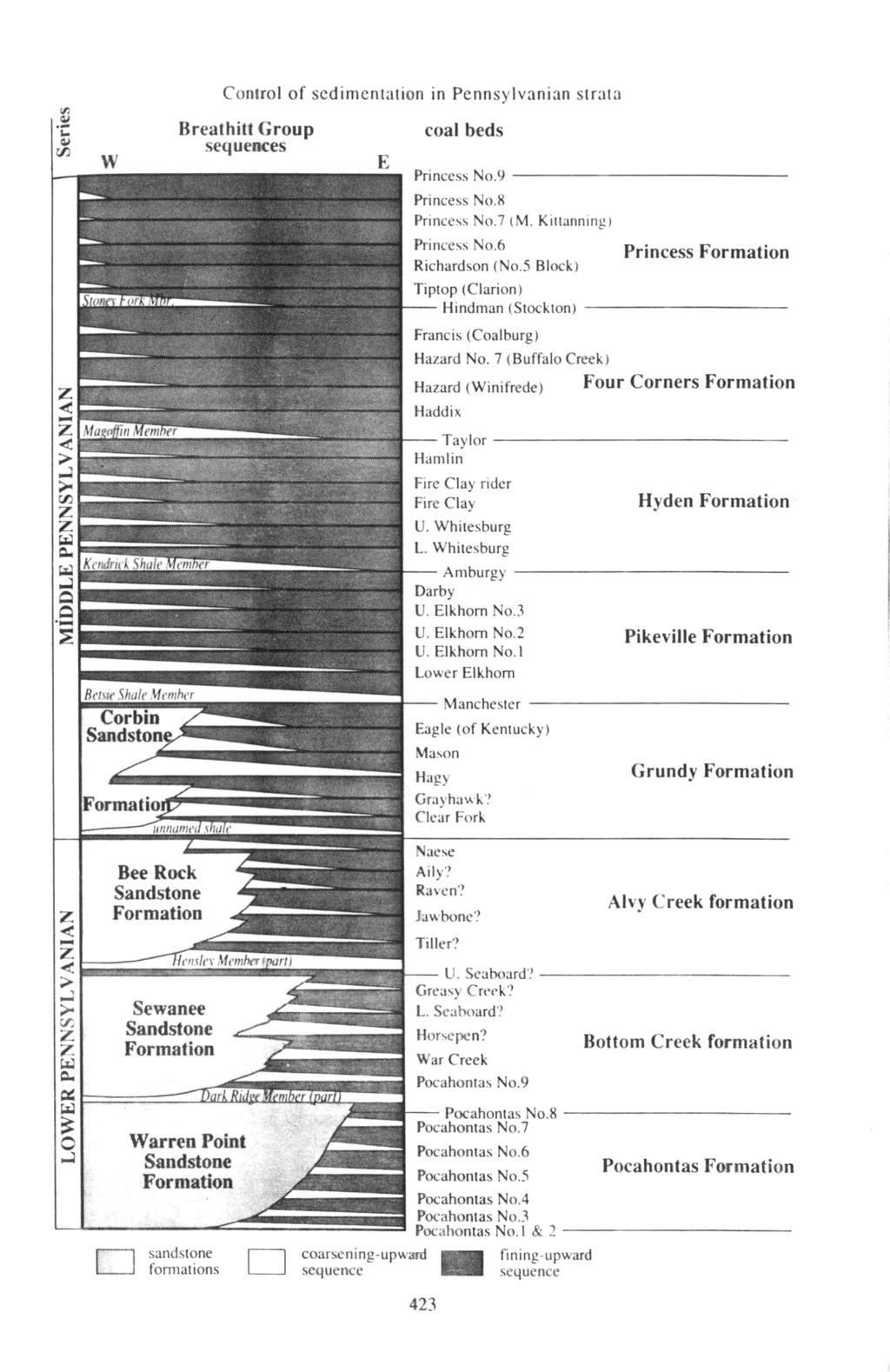
1 Comptes Rendus XII ICC-P Volume 2: Buenos Aires, 1993 EUSTATIC AND TECTONIC CONTROL OF SEDIMENTATION IN THE PENNSYLVANIAN STRATA OF THE CENTRAL APPALACHIAN BASIN, USA Donald R. CHESNUT Jr. Kentucky Geological Survey, 228 Mining and Mineral Resources Building, University of Kentucky. Lexington, KY, USA ARSTRACT. Analysis of the Breathitt Group (Lower and Middle Pennsylvanian) of the Central Appalachian Basin reveals three orders of depositional cycles or trends. The Breathitt coarsening-upward trend (20 miillion years (Ma)) represents increasing intensity of the Alleghanian Orogeny. The major marine trangression cycle (2.5 Ma) was controlled by an unknown eustatic or tectonic mechanism. The major coal beds and intervening strata make up the coal-clastic cycle (= Appalachian cyclothem), which has an 0.42 Ma periodicity. This periodicity supports an eustatic control of sedimentation modulaled by an orbital periodicity. Extensive coastal peats deposited at lowstand (coal-clastic cycle) were preserved as coals, whereas highstand peats were eroded during the subsequent drop in sea level. Autocyclic processes such as delta switching and avulsion occurred within coal-clastic cycles. Distribution of strata shows that the Early Pennsylvanian foreland basin was underfilled (i.e., the forebulge had not been crested). Alluvial deposits (Breathitt Formation) derived from the highlands were transported to the northwest toward the forebulge. During lowstand (major-marine transgression cycle), the only outlet available to further sediment transport (Lee Formation) was toward the southwest (Ouachita Trough), along the Black Warrior-Appalachian foreland basins. This transport was periodically interrupted by northeastward transgression (majormarine transgression cycle), from the trough through the foreland basins. The Middle Pennsylvanian marks a period of intermittent overfilling of the foreland basin and cresting of the forebulge. Marine transgressions (coal-clastic cycle) entered through the foreland basins and across saddles in the forebulge. After the Ouachita Trough was destroyed during the late Middle Pennsylvanian, marine transgressions migrated across saddles in the forebulge. In the Late Pennsylvanian, marine waters entered the basin only across the diminished forebulge north of the Jessamine Dome. INTRODUCTION The Central Appalachian Basin is one of the most important bituminous coal basins in the world (Fig.1). The Pennsylvanian coal-bearing rocks in the basin are composed of about 100 mineable coal beds separated stratigraphically by sandstones and shales. Basin analyses of these coal-bearing rocks support eustatic and tectonic control over sedimentation within the basin. STRATIGRAPHIC CYCLES AND TRENDS Stratigraphic analysis of the Breathitt Formation (Lower and Middle Pennsylvanian) (Fig. 2) reveals one overall trend and two orders of cycles. The Breathitt coarsening-upward trend (Fig. 2) can be seen as a general coarsening upward of the whole formation (disregarding the coarse sands of the Lee Formation, which derive from a different provenance). The Breathitt Formation is subdivided by several major marine strata into eight subequal formats (Fig. 2) representing the major-marine transgression cycle. The formats contain an average of six coal-clastic cycles, each made up of a major coal bed and overlying strata (Fig. 2). The average coal-clastic cycle (Fig. 3)

2 Donald R. Chesnut, Jr. Pennsylvanian Figure1. Location map of the Central Appalachian Basin is composed of a coal bcd overlain by a marine or brackish-water coarsening-upward scquence of shale and sandstone. The coarsening-upward sequence is truncated and overlain by a fining-upward sequence of sandstone, which, in turn, is capped by seatrock and another coal bed. The coa1-clastic cycle is equivalent to the Appalachian cyclothem. Figure 2. Schematic lithologic column of the Lower and Middle Pennsylvanian strata showing the Breathitt coarsening-upward trend, the major marine transgression cycle,. and the coal-clastic cycle. The Breathitt coarsening-upward trend reflects the general coarsening-upward grain size of the entire section (disregarding the Lee sandstone members, which represent a different provenance). The major-marine transgression cycles are equivalent to the eight mappable formats shown to the right. The major-marine transgression cycle is subdivided into an average of six coal and clastic units called Appalachian cyclothems, which represent the coal-clastic cycle. 422
3
4 Donald R. Chesnut Jr The major coal beds were once thought to be very limited in distribution and entirely controlled by autocyclic and tectonic mechanisms (Ferm, 1979). However, (1) detailed mapping at a scale of 1:24.000, (2) extensive coal-resource investigations, (3) distribution of tonsteins in coal beds, as well as (4) surface- and deep-mining records indicate that the major coal beds were extensive (more than 200 km in extent). A compilation of paleontological studies showed that a11 the major coal beds were overlain by marine or brackish strata over part or all their distribution in Kentucky (Chesnut, 1981, 1991b). The extensive nature of these coal-bearing cyclothems supports either eustatic or widespread tectonic control over sedimentation rather than autocyclic mechanisms such as delta switching or river avulsion. Chronologic analyses (see Chesnut, in press A), based on 10 different chronologic schemes developed during the last decade, provide the following cycle or trend durarions: the Breathitt coarsening-upward trend lasted an average of 20 Ma: the major-marine transgression cycle was about 2.5 Ma: and the coal-clastic cycle (Appalachian cyclothem) lasted about 0.42 Ma. The Breathitt coarsening-upward trend probably represents increasing intensity and proximity of the Alleghcnian (Hercynian) Orogeny. The 2.5 Ma periodicity of the major-marine transgression 424

5 Figure 4.Paleogeography during an Early Pennsylvanian extreme lowstand. Arrows indicate direction of clastic transport. cycle docs not match any known orbital or tectonic periodicity, and must be caused by unknown but recurring orbital or tectonic mechanisms. The 0.42 Ma periodicity of the coal-clastic cycle matches the second-order orbital eccentricity (Long Earth Periodicity) cycle (a Milankovitch cycle) that is known to modulate glaciation. This match supports a glacioeustatic control over deposition of the Appalachian cyclothem. Autocyclic processes, although not the dominant control, do have some affect upon the coal-bearing rocks. Autocyclic processes such as delta-switching and avulsion are represented within individual cyclothems. Perhaps some of the minor coal beds were deposited by these processes. The major coal beds of the Breathitt Formation, however, were deposited as lowstand peats, based upon vertical facies relationships (i.e., marine strata overlying coal beds) and the modern analog, the Indonesian cyclothem (see Chesnut and others, these proceedings). Peats were accumulated at the relative stasis of sea level change occurring at either high- or lowstand. Highstand peats were not preserved because of erosion during the subsequent drop in elevation. 425
6 Donald R. Chesnut Jr. Early Pennsylvanian highstand Figure 5. Paleogeography during an Early Pennsylvanian highstand. Large arrows indicate route of transgression. LOWSTAND AND HIGHSTAND PALEOGEOGRAPHY Little is known of the Pennsylvanian paleogeography of eastern North America at lowstand and highstand. Inferences can be made based on the distribution of strata within the basins (e.g., Nelson and others,. 1991a; Chesnut, in press B) and the distribution of biofacies within the marine strata (Chesnut, 1991b). Preliminary Pennsylvanian paleogeography maps based on these inferences arediscussed here. An Early Pennsylvanian (post mid-carboniferous unconformity) extreme lowstand is shown in Figure 4. During the Early Pennsylvanian, strata progressively onlapped the newly formed Appalachian and Illinois Basins, but had not covered the forebulge between the two basins. Current indicators show that immature clastics (represented by the Breathitt Formation) derived from the Appalachian Mountains were transported to the west (Fig. 4). At lowstand, the Breathitt rivers flowed into a large trunk transport system (represented by the Lee Formation sandbelts) flowing to the southwest. The Lee sandbelts were situated between the forebulge and the Breathitt clastic wedges and may ultimately have dumped sediment in- 426

7 Control of sedimentation in Pennsylvanian strata Figure 6. Paleogeography during a Middle Pennsylvanian extreme lowstand. Arrows indicate direction of clastic transport. to the Ouachita Trough to the west via the Black Warrior-Southern Appalachian Basins. On the western side of the forebulge, the similar Caseyville sandstone belt carried sand to the northeastern part of the trough. An Early Pennsylvanian highstand is shown in figure 5. Based on distribution of biofacies in the Eastern Kentucky Coal Field (Chesnut, 1991a & b) marine waters entered the Central Appalachian Basin from the south. Marine waters (represented by the Dark Ridge and Hensley members, Fig. 2) are inferred to have transgressed from the Ouachita trough (at extreme lowstand), through the Black Warrior-Southern Appalachian Basins, into the Central Appalachian Basin (Fig. 5). Marine waters also transgressed northeast across the Caseyville sandbelt: however, waters do not appear to have connected across the forcbulge separating the basins (Fig. 5). During most of the Middle Pennsylvanian (Fig. 6) trunk transport systems like the Lee and Caseyville sandbelts did not form at lowstand. Rather, Breathitt rivers apparently carried clastics over the forebulge at saddles formed in the forebulge (Fig. 6). The ultimate destination of the clastics may have been the Ouachita Trough and areas west of the trough. 421
8 Donald R. Chesnut Jr Middle Pennsylvanian highstand Figure 7. Paleogeography during a Middle Pennsylvanian highstand. Large arrows indicate route of transgression Preliminary biofacies distribution in marine strata in the central Appalachians indicates increasing marine conditions to the west and south during most of the Middle Pennsylvanian (Chesnut, 1991b). During rising sea level, marine waters apparently transgressed not only through the southern route to reach the Central Appalachian Basin, but also across saddles in the forebulge from thewestern basin(fig. 7). During the Late Pennsylvanian lowstands, transport direction of clastics was probably similar to that of the Middle Pennsylvanian (Fig. 6). However, the Ouachita Trough was destroyed by collisional tectonics during the late Middle and Late Pennsylvanian and could not have been the final destination of the Appalachian clastics. Clastic transport must have proceeded to the west. Rising sea levels during the Late Pennsylvanian (Fig. 8) could not transgress from the Ouachita Trough through the Black Warrior-Southern Appalachian Basins because the trough was destroyed. and the southern route may havc been blocked by the collisional tectonism. Transgressions must have proceeded through the Illinois Basin and entered the southern part of the Northern Appalachian Basin across a much diminished forebulge north of thejessamine Dome (Fig. 8). 428
9 Control of sedimentation in Pennsylvanian strata DISCUSSION The distribution of coastal landmasses at highstand and lowstand determine where coastal, domed peats may have accumulated and where thick coal may be found. In addition, the distribution of landmasses and large bodies of water may have had a great influence on regional climate. The differences in the distribution of land and water at lowstand and highstand can generate very different regional climates. In order to model regional climates, paleogeography at both highstand and lowstand must be determined. The preliminary inferences on Pennsylvanian paleogeography made here are not very detailed. Steps are being undertaken to refine or correct these interpretations using new data such as paleosol type, sulfur and ash-content of coals, paleobotanical data, and other information. These data are being compiled under the multi-institutional research initiative, Predictive Stratigraphic Analysis (C. Blaine Cecil and N. Terence Edgar, U. S. Geological Survey), in order to determine the role paleoclimate played in the Carboniferous rock record. 429
10 Donald R. Chesnut Jr. REFERENCES Chesnut, D. R., Marine Zones of the (Upper) Carboniferous of eastern Kentucky In: Cobb, J. C.. Chesnut, D. R.. Hester, N. C. and Hower, J. C. (Eds.). Coal and coal-bearing rocks of eastern Kentucky. Kentucky Geological Survey, Series 11, 169 p., 1991a. Marine transgressions in the Central Appalachian Basin during the Pennsylvanian Period. Geologi- In press A. Eustatic and tectonic control of the Lower and Middle Pennsylvanian rocks of the Central Appalachian Basin. Society of Economic Paleontologists and Mineralogists, Concepts in Sedimentology and Paleonto- logy, 4. cal Society of America, Abstract with Programs, 23: b. Paleontological survey of the Eastern Kentucky Coal Field: Invertebrates. Kentucky Geological Survey,Series 11, lnformation Circular. 36, 71 p. In press B. Stratigraphic analysis of the Carboniferous rocks of the Central Appalachian Barin. Kentucky Geological Survey, Series 11, Bulletin. Ferm, J. C., Pennsylvanian cyclothems of the Appalachian Plateau, a retrospective view In: Ferm, J. C. and Horne, J.C. (Eds.), Carboniferous depositional environment s in the Appalachian region. Columbia. South Carolina, Carolina Coal Group. 760 p. Nelson, W. J., Trask, C. B., Jacobson, R. J., Damberger, H. H., Williamson, A. D. & Williamson, D. A., Absaroka Sequence. Pennsylvanian and Permian Systems. In: Leighton, M. W. (Ed.), Interior cratonic sag basins. pp American Association of Petroleum Geologists. World Basin Series. 430
Plate tectonics model for the continental collisions during Late Paleozoic
 Alleghanian orogeny During Late Paleozoic, northwestern Africa collided with southeastern North America, causing the Alleghanian orogeny, and building the Appalachian mountains. The orogeny began during
Chapter 15. The Late Paleozoic World
 Chapter 15 The Late Paleozoic World Guiding Questions How did marine life of late Paleozoic time differ from that of middle Paleozoic time? How did terrestrial floras change on a global scale in late Paleozoic
Sequence Biostratigraphy and Depositional Modelling of the Pennsylvanian-Permian Belloy Formation Peace River Embayment, Alberta Canada
 Page No. 104-1 Sequence Biostratigraphy and Depositional Modelling of the Pennsylvanian-Permian Belloy Formation Peace River Embayment, Alberta Canada Lindsay A. Dunn* and Charles M. Henderson Applied
High-resolution Sequence Stratigraphy of the Glauconitic Sandstone, Upper Mannville C Pool, Cessford Field: a Record of Evolving Accommodation
 Page No. 069-1 High-resolution Sequence Stratigraphy of the Glauconitic Sandstone, Upper Mannville C Pool, Cessford Field: a Record of Evolving Accommodation Thérèse Lynch* and John Hopkins, Department
Sediment and Sedimentary rock
 Sediment and Sedimentary rock Sediment: An accumulation of loose mineral grains, such as boulders, pebbles, sand, silt or mud, which are not cemented together. Mechanical and chemical weathering produces
3. The diagram below shows how scientists think some of Earth's continents were joined together in the geologic past.
 1. The map below shows the present-day locations of South America and Africa. Remains of Mesosaurus, an extinct freshwater reptile, have been found in similarly aged bedrock formed from lake sediments
Ordovician. System. Cambrian. System
 443 495 543 Late Middle Early Late Middle Early Ordovician System Cambrian System Earth History, Ch. 13 1 Ch. 13 Review: Early Paleozoic life & Burgess Shale fauna Most animal phyla originated in Cambrian;
Depositional Sequences Sequences
 Depositional Sequences Transgressive and Regressive packages can be bound by unconformities Because sediment can only be preserved during net aggradation and progradation All other times there is either
Chapter 10. Early Paleozoic Events
 Chapter 10 Early Paleozoic Events The Phanerozoic Eon Consists of three eras (from oldest to youngest): Paleozoic = "ancient life" (542-251 m.y. ago) Mesozoic = "middle life" (251-65.5 m.y. ago) Cenozoic
Controls on facies distributions in the Charlie Lake Formation, Peace River Arch, Alberta
 Controls on facies distributions in the Charlie Lake Formation, Peace River Arch, Alberta E.L. Percy 12, C. Frostad 2, A. Juska 2, C. Schmidt 2, C. Sitzler 2, and J.P. Zonneveld 3 University of Calgary,
STRATIGRAPHIC CORRELATION OF THE LATE PENNSYLVANIAN- EARLY PERMIAN STRATA IN THE DELAWARE BASIN
 STRATIGRAPHIC CORRELATION OF THE LATE PENNSYLVANIAN- EARLY PERMIAN STRATA IN THE DELAWARE BASIN An Undergraduate Research Scholars Thesis by KIKE KOMOLAFE and KAELA DEMMERLE Submitted to the Undergraduate
Shallow marine facies. Outline 13: The Paleozoic World. Shallow marine and terrestrial facies
 Outline 13: The Paleozoic World Shallow marine and terrestrial facies Shallow marine facies Sea level was much higher than today during much of the Paleozoic. Shallow epicontinental seas flooded continental
Accommodation. Tectonics (local to regional) Subsidence Uplift
 Subsidence Uplift") Accommodation Accommodation varies over time; it is the distance between a reference horizon and the sea surface (i.e. relative sea level). The space to be filled in with sediments or water What are the
Accommodation Accommodation varies over time; it is the distance between a reference horizon and the sea surface (i.e. relative sea level). The space to be filled in with sediments or water What are the
Structural Features and Fracture Orientation similarities between outcrops of the Ridgeley Sandstone
 The JUNIATA JOURNAL of GEOLOGY, 1, 1-8 (2014) Original article Structural Features and Fracture Orientation similarities between outcrops of the Ridgeley Sandstone Robert W. Baronner Two outcrops of the
The Nature of Sedimentary Rocks
 The Nature of Sedimentary Rocks Sedimentary rocks are composed of: Fragments of other rocks Chemical precipitates Organic matter or biochemically produced materials The Nature of Sedimentary Rocks Sedimentary
Why is it called the "Inland Basins" Region?
 Learning Series: Rocks of the Southeastern U. S. The BIG Picture Why is it called the "Inland Basins" Region? Inland from the mountains, the Earth s crust was buckled (downwarped) into a series of depressions
GEOLOGICAL AGE OF ROCKS. Absolute geological age
 GEOLOGICAL AGE OF ROCKS Absolute geological age The pioneer of nuclear physics discovered at the turn of centuries that atoms of certain elements, the radioactive ones, spontaneously disintegrate to form
Moosehead Lake and the Tale of Two Rivers
 Maine Geologic Facts and Localities June, 2005 45 o 53 5.09 N, 69 o 42 14.54 W Text by Kelley, A.R.; Kelley, J.T.; Belknap, D.F.; and Gontz, A.M. Department of Earth Sciences, University of Maine, Orono,
University of Cincinnati P.O. Box 3092 Cincinnati, OH Houston, TX Department of Geological Sciences
 63 Tectono-Climatic Controls on Broad-Scale Patterns of Compositional Variation in the Upper Devonian Cleveland Member of the Ohio Shale, Central Appalachian Basin Jacek Jaminski 1,*, Thomas J. Algeo 1,
Terrain Units PALEOGEOGRAPHY: LANDFORM CREATION. Present Geology of NYS. Detailed Geologic Map of NYS
 NYS TOPOGRAPHY Why so? PALEOGEOGRAPHY: LANDFORM CREATION Prof. Anthony Grande AFG 014 Present Geology of NYS Detailed Geologic Map of NYS Generalized Geology Detailed Geology Hot links to the fold out
Sediment and sedimentary rocks Sediment
 Sediment and sedimentary rocks Sediment From sediments to sedimentary rocks (transportation, deposition, preservation and lithification) Types of sedimentary rocks (clastic, chemical and organic) Sedimentary
Lake Levels and Climate Change in Maine and Eastern North America during the last 12,000 years
 Maine Geologic Facts and Localities December, 2000 Lake Levels and Climate Change in Maine and Eastern North America during the last 12,000 years Text by Robert A. Johnston, Department of Agriculture,
Image: G. Parker. Presenters: Henry Chan, Kayla Ireland, Mara Morgenstern, Jessica Palmer, Megan Scott
 Image: G. Parker Presenters: Henry Chan, Kayla Ireland, Mara Morgenstern, Jessica Palmer, Megan Scott Is the Ross Formation a suitable analog for sand-rich turbidite plays in passive margin basins? Play:
EARTH SURFACE PROCESSES AND SEDIMENTATION!
 Sed and Strat EARTH SURFACE PROCESSES AND SEDIMENTATION! 2/27 Lecture 7- Exposure: Weathering and the Sediment Factory 3/04 Lecture 8 - Rivers and Landscapes 3/06 Lecture 9 - Waves (not Tides) 3/11 Lecture
Sedimentary Geology. Strat and Sed, Ch. 1 1
 Sedimentary Geology Strat and Sed, Ch. 1 1 Sedimentology vs. Stratigraphy Sedimentology is the study of the origin and classification of sediments and sedimentary rocks Mostly the physical and chemical
DO NOT WRITE ON THIS EXAM ONLY WRITE ON THE ANSWER SHEET!
 DO NOT WRITE ON THIS EXAM ONLY WRITE ON THE ANSWER SHEET! Multiple Choice Questions (30 points) for each question, please choose the best answer and circle your answer on the answer sheet (do not write
Case Study of the Structural and Depositional-Evolution Interpretation from Seismic Data*
 Case Study of the Structural and Depositional-Evolution Interpretation from Seismic Data* Yun Ling 1, Xiangyu Guo 1, Jixiang Lin 1, and Desheng Sun 1 Search and Discovery Article #20143 (2012) Posted April
of Pennsylvanian Marine Shale Beds from the Central Appalachian and Eastern Interior Basins
 Comparative 2014 Eastern Unconventional Oil and Organic Gas Symposium - November 5-7, 2014 in Petrography Lexington, Kentucky, USA http://www.euogs.org of Pennsylvanian Marine Shale Beds from the Central
PHYSIOGRAPHIC REGIONS OF THE LOWER 48 UNITED STATES
 PHYSIOGRAPHIC REGIONS OF THE LOWER 48 UNITED STATES LAURENTIAN UPLAND 1. Superior Upland ATLANTIC PLAIN 2. Continental Shelf (not on map) 3. Coastal Plain a. Embayed section b. Sea Island section c. Floridian
Seismic Stratigraphy of the Fang Basin, Chiang Mai, Thailand Rungsun Nuntajun
 Chiang Mai J. Sci. 2009; 36(1) 77 Chiang Mai J. Sci. 2009; 36(1) : 77-82 www.science.cmu.ac.th/journal-science/josci.html Contributed Paper Seismic Stratigraphy of the Fang Basin, Chiang Mai, Thailand
Viking Lowstand Deposits in West Central Saskatchewan: Depositional Model for the Reservoir Units in Dodsland-Hoosier Area, Saskatchewan, Canada
 Viking Lowstand Deposits in West Central Saskatchewan: Depositional Model for the Reservoir Units in Dodsland-Hoosier Area, Saskatchewan, Canada Hasan Ferdous* PetroSed Geoconsulting Resources, Calgary,
Sedimentary and Stratigraphic Analysis of the Viking Sand in the Edgerton/Wainwright Area, Central Alberta* By Russell Walz 1
 Sedimentary and Stratigraphic Analysis of the Viking Sand in the Edgerton/Wainwright Area, Central Alberta* By Russell Walz 1 Search and Discovery Article #50030 (2006) Posted June 25, 2006 *Extended abstract
The unknown giants - low-permeability shallow gas reservoirs of southern Alberta and Saskatchewan, Canada.
 The unknown giants - low-permeability shallow gas reservoirs of southern Alberta and Saskatchewan, Canada. Shaun O'Connell* Belfield Resources Inc., Calgary belfield@shaw.ca ABSTRACT The gas reserves contained
When last we left off. Western Cordillera NA. Cretaceous. Cretaceous, continued. Cretaceous to present
 When last we left off Western Cordillera NA Cretaceous to present Wild and weird things happened in the murky past of the Archean and precambrian Cambrian through Devonian development of deep water sediments
Calcite Cements in Middle Devonian Dunedin Formation:
 Geochemistry of the Fracture-Filling Dolomite and Calcite Cements in Middle Devonian Dunedin Formation: Implication for the Strata Dolomitization Model Sze-Shan Yip 1, Hairuo Qing 1 and Osman Salad Hersi
Depositional Environments. Depositional Environments
 Depositional Environments Geographic area in which sediment is deposited Characterized by a combination of geological process & environmental conditions Depositional Environments Geological processes:
The Pennsylvanian. Climate gone wild
 The Pennsylvanian Climate gone wild P. David Polly Department of Geological Sciences Indiana University Bloomington, Indiana 47405 USA pdpolly@indiana.edu Objectives 1. Pennsylvanian paleogeography and
Meandering Miocene Deep Sea Channel Systems Offshore Congo, West Africa
 Meandering Miocene Deep Sea Channel Systems Offshore Congo, West Africa S. Baer* (PGS), J. E. Comstock (PGS), K. Vrålstad (PGS), R. Borsato (PGS), M. Martin (PGS), J.P. Saba (SNPC), B. Débi-Obambé (SNPC)
=%REPORT RECONNAISSANCE OF CHISHOLM LAKE PROSPECT. October 25, 1977
 =%REPORT ON FIELD RECONNAISSANCE OF CHISHOLM LAKE PROSPECT October 25, 1977 Bruce D. Vincent Imperial Oil Limited, Minerals - Coal, CALGARY, ALBERTA CHISHOLM LAKE PROSPECT Introduction The Chisholm Lake
MUHAMMAD S TAMANNAI, DOUGLAS WINSTONE, IAN DEIGHTON & PETER CONN, TGS Nopec Geological Products and Services, London, United Kingdom
 Geological and Geophysical Evaluation of Offshore Morondava Frontier Basin based on Satellite Gravity, Well and regional 2D Seismic Data Interpretation MUHAMMAD S TAMANNAI, DOUGLAS WINSTONE, IAN DEIGHTON
Overview of Selected Shale Plays in New Mexico*
 Overview of Selected Shale Plays in New Mexico* Ron Broadhead 1 Search and Discovery Article #10627 (2014)** Posted August 18, 2014 *Adapted from presentation at RMAG luncheon meeting, Denver, Colorado,
Sequence Stratigraphy. Historical Perspective
 Sequence Stratigraphy Historical Perspective Sequence Stratigraphy Sequence Stratigraphy is the subdivision of sedimentary basin fills into genetic packages bounded by unconformities and their correlative
Mesozoic Earth History
 Mesozoic Earth History The Mesozoic Era 251-66 MYA Breakup of Pangea Changes in air and oceanic currents Evolution of new terrestrial and marine life Opening of the Atlantic Ocean Basin Rocky Mountains
TOPOGRAPHIC RELIEF MAP of NYS. LANDFORMS of NYS. Landforms. Creation of NYS Landforms 9/22/2011
 TOPOGRAPHIC RELIEF MAP of NYS LANDFORMS of NYS Prof. Anthony Grande AFG 2011 Landforms The basis of present-day landforms (surface features) is the bedrock geology that has been worked on by the forces
correlatives represent fluvial sandbelts oriented parallel
 262 correlatives represent fluvial sandbelts oriented parallel to the early Appalachian Mountains. The Breathitt Group represents short alluvial wedges prograding to the Lee sandbelts where the Breathitt
Bulletin of Earth Sciences of Thailand
 Depositional Environments and Stratigraphic Development of the Grand Taman Sari Circuit Outcrop: an Analogue for Transgressive Mahakam Delta Successions Ridha Santika Riadi Petroleum Geoscience Program,
Lab 7: Sedimentary Structures
 Name: Lab 7: Sedimentary Structures Sedimentary rocks account for a negligibly small fraction of Earth s mass, yet they are commonly encountered because the processes that form them are ubiquitous in the
GEL 113 Historical Geology
 GEL 113 Historical Geology COURSE DESCRIPTION: Prerequisites: GEL 111 Corequisites: None This course covers the geological history of the earth and its life forms. Emphasis is placed on the study of rock
251 Million years. 299 Million years. 318 Million years. 359 Million years
 The Late Paleozoic 251 Million years 299 Million years 318 Million years 359 Million years Major Questions How did marine life of late Paleozoic time differ from that of middle Paleozoic time? How did
Exploration, Drilling & Production
 Nontechnical Guide to PETMOLEUM Geology, Exploration, Drilling & Production Third Edition Norman J. Hyne, Ph.D. Contents Preface *i Introduction 1 The Nature of Gas and Oil 1 Petroleum 1 The Chemistry
Petroleum Potential of the Application Area L12-4
 Petroleum Potential of the Application Area L12-4 The Application Area (L12-4) is underlain by the western Officer Basin, beneath the Gunbarrel Basin. The general basin architecture is outlined in Figure
Carboniferous Stratigraphic Analysis in the Subandean Foothills and the Chaco Plains of Tarija Basin-Bolivia.
 AAPG Convention, Denver 2001 Carboniferous Stratigraphic Analysis in the Subandean Foothills and the Chaco Plains of Tarija Basin-Bolivia. VIERA, ATILIO F., Pluspetrol E&P, Buenos Aires, Argentina; HERNANDEZ
Continental Landscapes
 Continental Landscapes Landscape influenced by tectonics, climate & differential weathering Most landforms developed within the last 2 million years System moves toward an equilibrium Continental Landscapes
LANDFORMS of NYS. Landforms. Exercise 4 9/13/2012. TOPOGRAPHIC RELIEF MAP of NYS. Physiographic map of NYS and vicinity showing Surface Features
 TOPOGRAPHIC RELIEF MAP of NYS LANDFORMS of NYS Prof. Anthony Grande AFG 2012 Landforms REMINDER: The basis of present-day landforms (surface features) is the bedrock geology that has been worked on by
Carboniferous Stoddart Group: An integrated approach
 Carboniferous Stoddart Group: An integrated approach Abu Yousuf*, Department of Geoscience, University of Calgary, Calgary, Alberta yousufabu@hotmail.com and Charles M. Henderson, Department of Geoscience,
Cambrian Sedimentary Deposits - The Sauk Sequence
 Cambrian Sedimentary Deposits - The Sauk Sequence During Cambrian, there were no vascular plants on the land, so the landscape was barren. Erosion was active and severe without plant roots to hold the
RELINQUISHMENT REPORT. License P1546 Block April 2009
 RELINQUISHMENT REPORT License P1546 Block 110-01 14 April 2009 Sherritt International Oil and Gas Limited 2000, 425-1 st street S.W., Calgary, Alberta Canada T2P 3L8 Telephone (403) 260-2900 Fax (403)
SL GEOLOGY AND MINING. Coal bearing strata in the project area are referable primarily to the Allegheny Group of
 SL-145-1 GEOLOGY AND MINING Coal bearing strata in the project area are referable primarily to the Allegheny Group of Pennsylvania age. These rocks occur as dissected remnants overlying the ridge-forming
Sediment. Weathering: mechanical and chemical decomposition and disintegration of rock and minerals at the surface
 Sediment Some basic terminology Weathering: mechanical and chemical decomposition and disintegration of rock and minerals at the surface Erosion: removal of weathered rock and minerals from one place to
The Research of source system on Chang 6 3 sand formation in Ansai oilfield
 IOSR Journal of Engineering (IOSRJEN) ISSN (e): 2250-3021, ISSN (p): 2278-8719 Vol. 05, Issue 08 (August. 2015), V1 PP 25-29 www.iosrjen.org Wang Jie (College of Earth Sciences, Northeast Petroleum University,
Exploration Significance of Unconformity Structure on Subtle Pools. 1 Vertical structure characteristics of unconformity
 Exploration Significance of Unconformity Structure on Subtle Pools Wu Kongyou (China University of Petroleum,College of Geo-Resources and Information,Shandong Qingdao 266555) Abstract: Vertical structure
Sedimentary Processes and Stratigraphic Responses in a Tectonically Driven Basin: Northern California Continental Shelf and Upper Slope
 Sedimentary Processes and Stratigraphic Responses in a Tectonically Driven Basin: Northern California Continental Shelf and Upper Slope LONG-TERM GOALS Craig S. Fulthorpe and James A. Austin, Jr. This
Copyright McGraw-Hill Education. All rights reserved. No reproduction or distribution without the prior written consent of McGraw-Hill Education
 Copyright McGraw-Hill Education. All rights reserved. No reproduction or distribution without the prior written consent of McGraw-Hill Education Tibetan Plateau and Himalaya -southern Asia 11.00.a VE 10X
Lower Skinner Valley Fill Sandstones: Attractive Exploration Targets on the Northeast Oklahoma Platform*
 Lower Skinner Valley Fill Sandstones: Attractive Exploration Targets on the Northeast Oklahoma Platform* By Jim Puckette 1 Search and Discovery Article #10050 (2003) *Adapted from presentation to Tulsa
Sedimentary rocks. Mechanical Weathering. Weathering. Chemical weathering. Rates of weathering. Fossil Fuel Resources. Two kinds of weathering
 Sedimentary rocks Fossil Fuel Resources Exam next Tuesday February 14 Bring Scantron and Review Questions About 75% of all rock outcrops on the continents Important to reconstruct much of Earth's history
Holocene Lower Mississippi River Avulsions: Autogenic Versus Allogenic Forcing*
 Holocene Lower Mississippi River Avulsions: Autogenic Versus Allogenic Forcing* Eric Prokocki 1,2 Search and Discovery Article #50330 (2010) Posted October 14, 2010 *Adapted from oral presentation at AAPG
Dakota Sandstone. of the Moxa Arch and Surrounding Green River Basin
 Dakota Sandstone of the Moxa Arch and Surrounding Green River Basin Dakota Sandstones of the Green River Basin Overview The Dakota sandstones of the Moxa Arch and surrounding Green River Basin remain attractive
CHAPTER 2. GEOLOGIC SETTING Martin K. Dubois
 CHAPTER 2. GEOLOGIC SETTING Martin K. Dubois Regional Geology The Hugoton field lies on the west side of the Hugoton embayment of the Anadarko basin and is bounded to the northwest by the Las Animas arch
Plan of Development Mountain Valley Pipeline Project. APPENDIX P Plan for Unanticipated Discovery of Paleontological Resources
 APPENDIX P Plan for Unanticipated Discovery of Paleontological Resources Appendix P Plan for Unanticipated Discovery of Paleontological Resources Prepared by: TABLE OF CONTENTS 1.0 INTRODUCTION... 1 1.1
Geology 12 FINAL EXAM PREP. Possible Written Response Exam Questions
 Geology 12 FINAL EXAM PREP Possible Written Response Exam Questions Use this study guide to prepare for the written response portion of the final exam. Name FINAL EXAM - POSSIBLE WRITTEN RESPONSE QUESTIONS
Answers: Internal Processes and Structures (Isostasy)
") Answers: Internal Processes and Structures (Isostasy) 1. Analyse the adjustment of the crust to changes in loads associated with volcanism, mountain building, erosion, and glaciation by using the concept
Answers: Internal Processes and Structures (Isostasy) 1. Analyse the adjustment of the crust to changes in loads associated with volcanism, mountain building, erosion, and glaciation by using the concept
Bulletin of Earth Sciences of Thailand
 Quantitative Seismic Geomorphology of Early Miocene to Pleistocene Fluvial System of Northern Songkhla Basin, Gulf of Thailand Oanh Thi Tran Petroleum Geoscience Program, Department of Geology, Faculty
The Impact of Parasequence Stacking Patterns on Vertical Connectivity Between Wave-Dominated, Shallow Marine Parasequences, Book Cliffs, Eastern Utah
 The Impact of Parasequence Stacking Patterns on Vertical Connectivity Between Wave-Dominated, Shallow Marine Parasequences, Book Cliffs, Eastern Utah MALCOLM J. ARNOT and TIMOTHY R. GOOD* MALCOLM J. ARNOT
GEOLOGY MEDIA SUITE Chapter 8
 UNDERSTANDING EARTH, SIXTH EDITION GROTZINGER JORDAN GEOLOGY MEDIA SUITE Chapter 8 Clocks in Rocks Timing the Geologic Record 2010 W.H. Freeman and Company Stratigraphy and fossils Figure 8.4 (page 172)
Parameter Estimation and Sensitivity Analysis in Clastic Sedimentation Modeling
 Parameter Estimation and Sensitivity Analysis in Clastic Sedimentation Modeling A. Acevedo 1, A. Khramtsov 2, H. A. Madhoo 3, L. Noomee 4, and D. Tetzlaff 5 1 Schlumberger Information Solutions,Gatwick,
THE STRUCTURE AND THICKNESS OF THE CLINTON AND BEREA FORMATIONS IN THE VICINITY OF WOOSTER, OHIO
 THE STRUCTURE AND THICKNESS OF THE CLINTON AND BEREA FORMATIONS IN THE VICINITY OF WOOSTER, OHIO KARL VER STEEG College of Wooster INTRODUCTION AND ACKNOWLEDGMENTS The data used in the construction of
Application of Predictive Modeling to the Lower Cretaceous Sedimentary Sequences of the Central Scotian Basin
 Application of Predictive Modeling to the Lower Cretaceous Sedimentary Sequences of the Central Scotian Basin Christopher R. Sangster 1, Nicolas Hawie 2, Georgia Pe-Piper 1, Francky Saint-Ange 2, David
Sedimentary Cycle Best Practice: Potential Eo-Oligocene Sediments in Western Indonesia*
 Sedimentary Cycle Best Practice: Potential Eo-Oligocene Sediments in Western Indonesia* Mellinda Arisandy 1 and I Wayan Darma 1 Search and Discovery Article #11008 (2017)** Posted November 6, 2017 *Adapted
Stratigraphic Trap Identification Based on Restoration of Paleogeophology and Further Division of System Tract: A Case Study in Qingshui Subsag*
 Stratigraphic Trap Identification Based on Restoration of Paleogeophology and Further Division of System Tract: A Case Study in Qingshui Subsag* Cao Laisheng 1, Yu Lin 1, Liu Jianlun 1, Xiang Sheng 1,
Sequence Stratigraphy as a tool for water resources management in alluvial coastal aquifers: application to the Llobregat delta (Barcelona, Spain)
") Sequence Stratigraphy as a tool for water resources management in alluvial coastal aquifers: application to the Llobregat delta (Barcelona, Spain) Desiré Gàmez Torrent December 2007 CHAPTER 1: Introduction
Sequence Stratigraphy as a tool for water resources management in alluvial coastal aquifers: application to the Llobregat delta (Barcelona, Spain) Desiré Gàmez Torrent December 2007 CHAPTER 1: Introduction
Nathan D. Webb and James L. Best
 Nathan D. Webb and James L. Best Background Pennsylvanian oil production Stratigraphy & geologic setting Study area Methods Using geophysical logs & core Results Comparing three channel deposits Implications
Donald R. Chesnut, Jr. and James C. Cobb. (Kentucky Geological Survey, Lexington, Kentucky, USA) Robert A. Gastaldo
 Robert A. Gastaldo") XI Congres International de Stratigraphie et de Geologie du Carbonifere Beijing 1987, Compte Rendu 2 (1989): 20-30 ORIGIN OF THE MIDDLESBORO MEMBER OF THE LOWER PENNSYLVANIAN-AGE LEE FORMATION (BASHKIRIAN)
XI Congres International de Stratigraphie et de Geologie du Carbonifere Beijing 1987, Compte Rendu 2 (1989): 20-30 ORIGIN OF THE MIDDLESBORO MEMBER OF THE LOWER PENNSYLVANIAN-AGE LEE FORMATION (BASHKIRIAN)
GY 111: Physical Geology
 UNIVERSITY OF SOUTH ALABAMA GY 111: Physical Geology Lecture 14: Sedimentary Rocks Part 2: Alluvial Fans and Rivers Instructor: Dr. Douglas W. Haywick Last Time 1) Types of Sediment 2) Sedimentary Rock
Jordan. Target Exploration. Target Exploration
 Page1 barr Target Exploration Target Exploration barr Target Exploration Target Exploration Petroleum Potential of Wadi Sirhan Basin Jordan Petroleum Potential of Wadi Sirhan Basin, Jordan Sequence Stratigraphy,
NAME: GEL 109 Final Study Guide - Winter 2008 Questions 6-24 WILL be on the final exactly as written here; this is 60% of the test.
 GEL 109 Final Study Guide - Winter 2008 Questions 6-24 WILL be on the final exactly as written here; this is 60% of the test. 1. Sketch a map view of three types of deltas showing the differences in river,
Bulletin of Earth Sciences of Thailand. Evaluation of the Petroleum Systems in the Lanta-Similan Area, Northern Pattani Basin, Gulf of Thailand
 Evaluation of the Petroleum Systems in the Lanta-Similan Area, Northern Pattani Basin, Gulf of Thailand Sirajum Munira Petroleum Geoscience Program, Department of Geology, Faculty of Science, Chulalongkorn
Ministry of Oil and Minerals Petroleum Exploration & Production Authority BLOCK 85 (Al Uqlah North)
") Ministry of Oil and Minerals Petroleum Exploration & Production Authority BLOCK 85 (Al Uqlah North) The Al Uqlah North Block (85) occupies an area of 597 km 2 in the Sabatayn Basin in the province of Shabwah
Ministry of Oil and Minerals Petroleum Exploration & Production Authority BLOCK 85 (Al Uqlah North) The Al Uqlah North Block (85) occupies an area of 597 km 2 in the Sabatayn Basin in the province of Shabwah
The boundary between two formations (or any distinct layers) is called a contact. Sedimentary rocks cover 75% of continents.
 is called a contact. Sedimentary rocks cover 75% of continents.") Sedimentary Rocks Sedimentary rocks form at the Earth s surface through interactions of the hydrologic system and the crust. Fortunately, many of these processes are in operation today, and geologists
Sedimentary Rocks Sedimentary rocks form at the Earth s surface through interactions of the hydrologic system and the crust. Fortunately, many of these processes are in operation today, and geologists
State the principle of uniformitarianism. Explain how the law of superposition can be used to determine the relative age of rocks.
 Objectives State the principle of uniformitarianism. Explain how the law of superposition can be used to determine the relative age of rocks. Compare three types of unconformities. Apply the law of crosscutting
Igneous and Metamorphic Rock Forming Minerals. Department of Geology Mr. Victor Tibane SGM 210_2013
 Igneous and Metamorphic Rock Forming Minerals Department of Geology Mr. Victor Tibane 1 SGM 210_2013 Classification of sedimentary rocks Sedimentary rocks are products of weathered, fragmented or dissolved,
APPENDIX C GEOLOGICAL CHANCE OF SUCCESS RYDER SCOTT COMPANY PETROLEUM CONSULTANTS
 APPENDIX C GEOLOGICAL CHANCE OF SUCCESS Page 2 The Geological Chance of Success is intended to evaluate the probability that a functioning petroleum system is in place for each prospective reservoir. The
STARKE MINES. by MICHELLE ROGERS ~MMITCHEL/HON399/MICHELLE.HTM ORIGINALLY PUBLISHED IN
 STARKE MINES by MICHELLE ROGERS ORIGINALLY PUBLISHED IN HTTP://WWW.VALDOSTA.EDU/ ~MMITCHEL/HON399/MICHELLE.HTM ORIGINALLY PUBLISHED IN HTTP://WWW.VALDOSTA.EDU/ ~MMITCHEL/HON399/MICHELLE.HTM STARKE MINES
3/5/05 Dr. Stewart 1
 I. Physiography of Appalachian Mountains A. Introduction 1. These mountains extend from NE Canada to Georgia 2. They are the remains of a deeply eroded, ancient mountain chain once larger than the Himalayans
transform boundary Photograph by Robert E. Wallace, USGS.
 transform boundary The San Andreas Fault is undoubtedly the most famous transform boundary in the world. To the west of the fault is the Pacific plate, which is moving northwest. To the east is the North
4.1 Sediment accommodation space principles and controls
 58 The sedimentary record of sea-level change 4. Sediment accommodation space principles and controls Sequence stratigraphy emphasizes the importance of the space that is made available within a basin
Abstract. Introduction. Regional Setting. GCSSEPM to be published December 2003
 Shelf Margin Deltas and Associated Deepwater Deposits: Implications on Reservoir Distribution and Hydrocarbon Entrapment, Block VI-1, Ulleung Basin, East Sea, South Korea Sneider, John S. Sneider Exploration,
discussion of North America s physical features, including its landforms and bodies of
 Chapter 7 Natural Environments of North America Chapter 7 focuses on the natural environments of North America. The chapter opens with a discussion of North America s physical features, including its landforms
Ministry of Oil and Minerals Petroleum Exploration & Production Authority BLOCK 6 (Iryam)
") Ministry of Oil and Minerals Petroleum Exploration & Production Authority BLOCK 6 (Iryam) The Iryam Block (6) occupies an area of 3,911 km 2 in the Sabatayn Basin in the province of Shabwah in central
Ministry of Oil and Minerals Petroleum Exploration & Production Authority BLOCK 6 (Iryam) The Iryam Block (6) occupies an area of 3,911 km 2 in the Sabatayn Basin in the province of Shabwah in central
KEY CHAPTER 12 TAKE-HOME QUIZ INTERNAL STRUCTURES AND PROCESSES Score Part B = / 55 PART B
 GEOLOGY 12 KEY CHAPTER 12 TAKE-HOME QUIZ INTERNAL STRUCTURES AND PROCESSES Score Part B = / 55 PART B CHAPTER 12 Isostacy and Structural Geology 1. Using the terms below, label the following diagrams and
Summary. Introduction. Observations and Interpretations
 Lower McMurray Formation sinkholes and their fill fabrics: effects of salt dissolution collapse-subsidence across the northern Athabasca oil sands deposit Paul L. Broughton, Chevron Canada Resources, Calgary,