Cambrian Sedimentary Deposits - The Sauk Sequence
|
|
|
- Morris Mills
- 5 years ago
- Views:
Transcription
1 Cambrian Sedimentary Deposits - The Sauk Sequence During Cambrian, there were no vascular plants on the land, so the landscape was barren. Erosion was active and severe without plant roots to hold the soil. After Neoproterozoic glaciation, the sea transgressed onto the craton. Shoreline (beach) deposition produced a vast apron of clean quartz sand. Carbonate deposition occurred farther from land.
2 Cambrian Deposits of the Grand Canyon Region In the Grand Canyon region, the Lower Cambrian Tapeats Sandstone is an example of the sandy beach deposits unconformably overlying Precambrian rocks.

3 Tapeats Sandstone, Grand Canyon

4 The Tapeats is a massive cliff-forming unit of brown sandstone. Much of the sand is very coarse-grained, often pea-sized or larger, and some grains are beautifully colored-- students call this the M&M conglomerate. The Tapeats Sandstone represents nearshore beach and sand bar deposits. The base of the Tapeats contains a conglomerate member (part of the Tapeats), called the Hotauta Conglomerate. This was a pebble beach formed as the Tonto Sea encroached and tore up the Vishnu, so the Hotauta contains schist and granite pebbles.
5 Tapeats Sandstone is overlain by Bright Angel Shale, an offshore deposit. Bright Angel Shale is overlain by Muav Limestone, deposited farther from land. These rocks form a transgressive sequence.
6 These sedimentary units are diachronous (i.e., they cut across time lines). In each case, the sedimentary units are older in the west than in the east. The red lines are trilobite zones, which approximate time lines.


7 Left: Glossopleura gigantea 5.3" Trilobite, Spence Shale Formation, Hansen Canyon, Cambrian, Wellsville Mountains, Box Elder Co., Utah. Right: Glossopleura bion 3.9" Trilobite with bite mark, Spence Shale Formation, Cambrian, Miners Hollow, Wellsville Mountains, Box Elder Co., Utah
, making them good index fossils.")

8 Left: Nevada Cambrian Trilobite Olenellus gilberti, a beautifully preserved specimen of this widespread species that is found in Nevada and California. The genus is restricted to the early Cambrian ( million years ago), making them good index fossils. They have a most distinctive large cephalon containing crescentic eyes, making them quite attractive to collectors. Most are only found as a preserved cephalon, making those from the famous Pioche Shale highly desirable. Right: Olenellus fowleri, This is a particularly well preserved specimen of Olenellus fowleri. It has very good color and presence. All the spines and the delicate opistothorax are preserved. There is some damage to the glabella. The species has been recently described in It is one of the rarer species found at this location. The genus is restricted to the early Cambrian ( million years ago), making them good index fossils. They have a most distinctive large cephalon containing crescentic eyes, and most are only found as a preserved cephalon.

9 The three facies (sandstone, shale, and limestone) coexisted and migrated laterally as sea level rose. The Bright Angel Shale is Lower Cambrian in the west, and Middle Cambrian in the east.
10 Near the end of Early Ordovician, the seas regressed (due to glaciation). The Muav Limestone was exposed to subaerial erosion and a widespread unconformity developed.

11 Ordovician Paleogeography Note the mountains and volcanoes in the Appalachian region. Volcanic ash deposits are found in Ordovician rocks throughout the eastern U.S. (Now altered to a clay called bentonite).
12 Ordovician orogenies The Taconic Orogenic Belt lay between Laurentia (North America) and Baltica (Europe and western Russia) during Ordovician.

13 Plate tectonic cross-section showing forces that caused the Taconic Orogeny.
14 A - Eastern North America during Cambrian and Early Ordovician, following the breakup of Rodinia. B - Large volcanic island arc nears eastern North America. C - Volcanic island arc collides with eastern North America causing Taconic orogeny.
15 Volcanic Island Arc Collides with Eastern North America As the Iapetus Ocean narrowed, a volcanic island arc approached and collided with the North American craton, causing folding, faulting, metamorphism, and mountain building. This mountain-building event in the Appalachian region is called the Taconic orogeny ( m.y. ago).

16 Upper Ordovician Sedimentary Deposits As the Taconic mountain belt eroded, Upper Ordovician to Lower Silurian red sandstones and shales were deposited to the west in huge delta systems.

17 Ordovician shales, New York
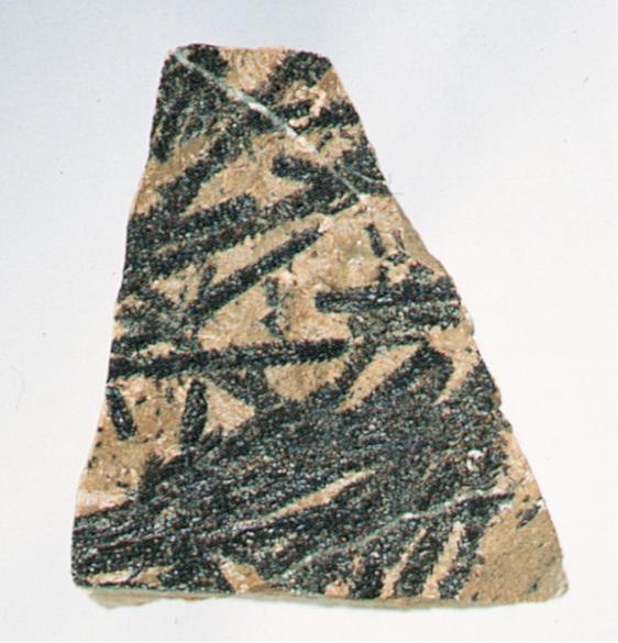
18 Ordovician graptolites
19 Ordovician graptolites

20 Ordovician graptolite facies

21 Eurypterids were impressively size arthropods that crawled out on land and could reach 10 feet.
22 Caledonian Orogenic Belt The Caledonian orogenic belt (which extends along the northwestern edge of Europe) is part of the same trend as the Taconic orogenic belt. The Caledonian orogeny reached its climax slightly later, during Late Silurian to Early Devonian. The Caledonian event is recognized in the Canadian Maritime Provinces, northeastern Greenland, northwestern Great Britain, and Norway.
23 Silurian global conditions Silurian sea levels were high worldwide. In Laurentia (North America), much of the craton was flooded, indicating melting of Late Ordovician glaciers. This was the second major transgression during Paleozoic, which deposited the Tippecanoe Sequence.

24 Silurian Paleogeography Mountains in eastern N. America are eroding. Sandstone & conglomerat deposits. Widespread carbonate deposition. Deep marine deposits in NW and SE U.S. Reefs and evaporites.
25 Silurian Sedimentary Deposits As the Tippecanoe Sea flooded North America, deposition began with nearshore sands. These include the famous St. Peter Sandstone, an unusually pure, well sorted, well rounded quartz sandstone. Silurian Tuscarora Sandstone was deposited in the central Appalachian region.
26 Silurian Sedimentary Deposits Sandstone is overlain by extensive limestone deposits, locally replaced by dolomite. In eastern U.S., limestones are overlain by and interbedded with shales along the periphery of the Queenston delta. Niagara Falls is a classic locality where these rocks are exposed.

27
28 Silurian Michigan Basin Evaporites Near the end of the Tippecanoe sequence, reef-fringed basins developed, such as the Michigan Basin. Evaporation led to the precipitation of immense quantities of rock salt and gypsum within the basin, indicating an arid paleoclimate. Evaporite minerals total over 2500 ft (750 m) thick in the Michigan Basin.
 in the world, and these sediments have been")
29 Isopach map shows thickness in feet of late Silurian evaporite basins. The Michigan Basin is one of the greatest areas of rock salt (and other evaporites like gypsum) in the world, and these sediments have been the basis of major chemical and plasterboard industries in Michigan.

30 The rate of subsidence within the Michigan Basin then increased markedly, and a series of coral reefs developed along the Kankakee Arch and in the shallow waters along the western and southern margins of the basin. Some of these reefs can be seen today on the south side of Chicago, and I-94 crosses over a giant quarry into one of them. But the genial climates of the Silurian came to an end. The close of the Silurian was a long time of aridity in which the seas became so salty that living creatures swam to a more suitable home. The conditions were roughly analogous to the present-day Mediterranean Sea where water from the Atlantic flows in over the rather shallow restriction at the Straits of Gibraltar. The arid climate in the region evaporates the sea water and concentrates the salt. The heavier, highly saline water sinks to the bottom and cannot escape and therefore tends to accumulate. Great salt beds (named the Salina Salt Beds) were deposited in the basin. In the central part of the basin 2300 feet of alternating salt, shale, and limestone beds have been penetrated in the Salina, with 1600 feet of rock salt.

31 Silurian Iron Ore Economically important sedimentary iron ore deposits accumulated during Silurian in the southern Appalachians, particularly around Birmingham, Alabama. Steel was produced for many years in Birmingham from this iron ore. Fuel was supplied by nearby Late Paleozoic coal deposits. Limestone, also found nearby, was used as flux in the blast furnace.
32 Silurian Orogenic Activity Orogenic activity (mountain building) was more or less continuous at one place or another during Silurian and Devonian. The Caledonian orogeny was most intense in Norway, as the Iapetus Ocean closed. The folded rocks of the Caledonians end in Ireland, but can be traced to NE Greenland, Newfoundland, and Nova Scotia, Canada.

33 Jasper National Park, Alberta with lower Paleozoic sedimentary rocks in the distance

34 Paleozoic review
Chapter 10. Early Paleozoic Events
 Chapter 10 Early Paleozoic Events The Phanerozoic Eon Consists of three eras (from oldest to youngest): Paleozoic = "ancient life" (542-251 m.y. ago) Mesozoic = "middle life" (251-65.5 m.y. ago) Cenozoic
Ordovician. System. Cambrian. System
 443 495 543 Late Middle Early Late Middle Early Ordovician System Cambrian System Earth History, Ch. 13 1 Ch. 13 Review: Early Paleozoic life & Burgess Shale fauna Most animal phyla originated in Cambrian;
DO NOT WRITE ON THIS EXAM ONLY WRITE ON THE ANSWER SHEET!
 DO NOT WRITE ON THIS EXAM ONLY WRITE ON THE ANSWER SHEET! Multiple Choice Questions (30 points) for each question, please choose the best answer and circle your answer on the answer sheet (do not write
Quiz Nine (9:30-9:35 AM)
") Quiz Nine (9:30-9:35 AM) UNIVERSITY OF SOUTH ALAAMA GY 112: Earth History Lecture 25: Paleozoic 2: More Laurentia! Instructor: Dr. Douglas W. Haywick Last Time The Paleozoic of North America 1) Laurentian
Quiz Nine (9:30-9:35 AM) UNIVERSITY OF SOUTH ALAAMA GY 112: Earth History Lecture 25: Paleozoic 2: More Laurentia! Instructor: Dr. Douglas W. Haywick Last Time The Paleozoic of North America 1) Laurentian
Lecture 24: Paleozoic 1:
 UNIVERSITY OF SOUTH ALABAMA GY 112: Earth History Lecture 24: Paleozoic 1: Laurentia Instructor: Dr. Douglas W. Haywick Last Time (before the exam) The Cambrian Explosion A) Why a Cambrian explosion B)
The Building of the NYC Region
 The Building of the NYC Region Definitions Fall Line marks the area where an upland region (continental bedrock) and a coastal plain meet Piedmont the plateau region of the eastern United States which
Sediment and sedimentary rocks Sediment
 Sediment and sedimentary rocks Sediment From sediments to sedimentary rocks (transportation, deposition, preservation and lithification) Types of sedimentary rocks (clastic, chemical and organic) Sedimentary
Plate tectonics model for the continental collisions during Late Paleozoic
 Alleghanian orogeny During Late Paleozoic, northwestern Africa collided with southeastern North America, causing the Alleghanian orogeny, and building the Appalachian mountains. The orogeny began during
As compaction and cementation of these sediments eventually occur, which area will become siltstone? A) A B) B C) C D) D
 A B) B C) C D) D") 1. A student obtains a cup of quartz sand from a beach. A saltwater solution is poured into the sand and allowed to evaporate. The mineral residue from the saltwater solution cements the sand grains together,
1. A student obtains a cup of quartz sand from a beach. A saltwater solution is poured into the sand and allowed to evaporate. The mineral residue from the saltwater solution cements the sand grains together,
3/5/05 Dr. Stewart 1
 I. Physiography of Appalachian Mountains A. Introduction 1. These mountains extend from NE Canada to Georgia 2. They are the remains of a deeply eroded, ancient mountain chain once larger than the Himalayans
The Mesozoic. Wednesday, November 30, 11
 The Mesozoic Periods of the Mesozoic Triassic- First period of the Mesozoic era Jurassic Cretaceous- Last period of the Mesozoic era Breakup of Pangaea Stage one (Triassic) Rifting and volcanism, normal
The Nature of Sedimentary Rocks
 The Nature of Sedimentary Rocks Sedimentary rocks are composed of: Fragments of other rocks Chemical precipitates Organic matter or biochemically produced materials The Nature of Sedimentary Rocks Sedimentary
Unconformities are depositional contacts that overlie rocks distinctly older than they are. They are often called gaps in the sedimentary record.
 UNCONFORMITIES Unconformities are depositional contacts that overlie rocks distinctly older than they are. They are often called gaps in the sedimentary record. The contact represents time when no sediment
Lecture Outlines PowerPoint. Chapter 12 Earth Science 11e Tarbuck/Lutgens
 Lecture Outlines PowerPoint Chapter 12 Earth Science 11e Tarbuck/Lutgens 2006 Pearson Prentice Hall This work is protected by United States copyright laws and is provided solely for the use of instructors
Why is it called the "Inland Basins" Region?
 Learning Series: Rocks of the Southeastern U. S. The BIG Picture Why is it called the "Inland Basins" Region? Inland from the mountains, the Earth s crust was buckled (downwarped) into a series of depressions
The Building of a Continent. Delving into Deep Time
 The Building of a Continent Delving into Deep Time Methods for Studying the Past Identifying orogenies Mountain building events Mountains erode Can t study topography Study the evidence they leave behind
Comprehensive Final Exam EXAM RETURN EXAM RETURN EXAM RETURN
 Exams will be returned 15 minutes before end. RESULTS: A: B: C: D: F: % of class got As and Bs CONGRATS! % got a D or less If your grade is what you want, keep up the good work! If not, see me for advice.
Sediment. Weathering: mechanical and chemical decomposition and disintegration of rock and minerals at the surface
 Sediment Some basic terminology Weathering: mechanical and chemical decomposition and disintegration of rock and minerals at the surface Erosion: removal of weathered rock and minerals from one place to
Lecture Outline Wednesday - Friday February 14-16, 2018
 Lecture Outline Wednesday - Friday February 14-16, 2018 Quiz 2 scheduled for Friday Feb 23 (Interlude B, Chapters 6,7) Questions? Chapter 6 Pages of the Past: Sedimentary Rocks Key Points for today Be
L.O: HOW GEOLOGISTS SEQUENCE EVENTS IN EARTH'S GEOLOGIC HISTORY IF NOT OVERTURNED, OLDEST ON BOTTOM, YOUNGEST ON TOP
 L.O: HOW GEOLOGISTS SEQUENCE EVENTS IN EARTH'S GEOLOGIC HISTORY IF NOT OVERTURNED, OLDEST ON BOTTOM, YOUNGEST ON TOP 1. Unless a series of sedimentary rock layers has been overturned, the bottom rock layer
Lab 7: Sedimentary Structures
 Name: Lab 7: Sedimentary Structures Sedimentary rocks account for a negligibly small fraction of Earth s mass, yet they are commonly encountered because the processes that form them are ubiquitous in the
Name: Date: Period: Page 1
 Name: Date: Period: Base your answers to questions 1 through 4 on the three bedrock outcrops below and on your knowledge of Earth science. The outcrops, labeled I, II, and III, are located within 15 kilometers
GY 111 Lecture Notes Thrust Faults and the Appalachian Mountains
 GY 111 Lecture Notes D. Haywick (2007-08) 1 Lecture Goals: A) Thrust Faults B) The Appalachian Mountains GY 111 Lecture Notes Thrust Faults and the Appalachian Mountains Reference: Press et al., 2004,
Sedimentology & Stratigraphy. Thanks to Rob Viens for slides
 Sedimentology & Stratigraphy Thanks to Rob Viens for slides Sedimentology The study of the processes that erode, transport and deposit sediments Sedimentary Petrology The study of the characteristics and
Earth Science. Name Block. Unit 3 Review Worksheet. Circle the letter that corresponds to the correct answer
 Earth Science Unit 3 Review Worksheet Name Block Circle the letter that corresponds to the correct answer 1. Which geologic principle is used when a geologist observes an outcrop or rocks and determines
Geological History of the Grand Canyon
 Geological History of the Grand Canyon For a copy of this assignment, print a copy of this web page. The Project Your job is to write a short paper that describes the geological history of the Grand Canyon
Shield was above sea-level during the Cambrian and provided the sediment for the basins.
 Name: Answers Geology 1023 Lab #8, Winter 2014 Platforms and Paleozoic life-forms Lab day: Tu W Th 1. Schematic geologic cross-sections A-B and C-D (shown below) cross the edge of the continental platform
1. Base your answer to the following question on The diagram below represents a part of the crystal structure of the mineral kaolinite.
 1. Base your answer to the following question on The diagram below represents a part of the crystal structure of the mineral kaolinite. An arrangement of atoms such as the one shown in the diagram determines
Mesozoic Earth History
 Mesozoic Earth History The Mesozoic Era 251-66 MYA Breakup of Pangea Changes in air and oceanic currents Evolution of new terrestrial and marine life Opening of the Atlantic Ocean Basin Rocky Mountains
Copyright McGraw-Hill Education. All rights reserved. No reproduction or distribution without the prior written consent of McGraw-Hill Education
 Copyright McGraw-Hill Education. All rights reserved. No reproduction or distribution without the prior written consent of McGraw-Hill Education Tibetan Plateau and Himalaya -southern Asia 11.00.a VE 10X
Structural Geology of the Mountains
 Structural Geology of the Mountains Clinton R. Tippett Shell Canada Limited, Calgary, Alberta clinton.tippett@shell.ca INTRODUCTION The Southern Rocky Mountains of Canada (Figure 1) are made up of several
Geology of the Batemans Bay region. Geological evolution. The Lachlan Orogen
 Australian Journal of Earth Sciences 1 The word orogen is derived from the ancient Greek language word for mountain building. The Lachlan Orogen The rocks exposed in the Batemans Bay are part of the geological
TOPOGRAPHIC RELIEF MAP of NYS. LANDFORMS of NYS. Landforms. Creation of NYS Landforms 9/22/2011
 TOPOGRAPHIC RELIEF MAP of NYS LANDFORMS of NYS Prof. Anthony Grande AFG 2011 Landforms The basis of present-day landforms (surface features) is the bedrock geology that has been worked on by the forces
The United States & Canada. A Regional Study of Anglo America
 A Regional Study of Anglo America Landform Regions of the United States & Canada world leaders in agricultural and industrial production because of... VAST LANDS stretch from the Atlantic Ocean on the
GY 112 Lecture Notes Laurentia in the Paleozoic (non-tectonics)
") GY 112 Lecture Notes D. Haywick (2006) 1 GY 112 Lecture Notes Laurentia in the Paleozoic (non-tectonics) Lecture Goals: A) Eastern Laurentia (pre-orogenic deposition) B) Central North America (Depositional
GY 112 Lecture Notes D. Haywick (2006) 1 GY 112 Lecture Notes Laurentia in the Paleozoic (non-tectonics) Lecture Goals: A) Eastern Laurentia (pre-orogenic deposition) B) Central North America (Depositional
Engineering Geology ECIV 2204
 Engineering Geology ECIV 2204 Instructor : Dr. Jehad Hamad 2017-2016 Chapter (6) : Sedimentary Rocks Chapter 6: Sedimentary Rocks Chapter 6: Sedimentary Rocks Origin and nature of sedimentary rocks: Sedimentary
FIREPLACE GEOLOGY. Dining Hall
 FIREPLACE GEOLOGY Dining Hall The Dining Hall fireplace represents a slice through a Cascade Mountain volcano. Volcanoes are formed from molten magma rising up from within the Earth s crust. Magma that
Geology of the Hawaiian Islands
 Geology of the Hawaiian Islands Class 12 19 February 2004 A B C D F 97 94 92 91 88 87 86 85 85 84 82 77 73 73 mean 66 64 60 69 60 57 51 29 Exam Scores Mean = 71 Median = 82/77 Any Questions? Sedimentary
C) Trenton limestone
 Trenton limestone") 1. Base your answer to the following question on the Earth Science Reference Tables, the core section below, and your knowledge of Earth Science. The core section shows the subsurface bedrock geology for
1. Base your answer to the following question on the Earth Science Reference Tables, the core section below, and your knowledge of Earth Science. The core section shows the subsurface bedrock geology for
The boundary between two formations (or any distinct layers) is called a contact. Sedimentary rocks cover 75% of continents.
 is called a contact. Sedimentary rocks cover 75% of continents.") Sedimentary Rocks Sedimentary rocks form at the Earth s surface through interactions of the hydrologic system and the crust. Fortunately, many of these processes are in operation today, and geologists
Sedimentary Rocks Sedimentary rocks form at the Earth s surface through interactions of the hydrologic system and the crust. Fortunately, many of these processes are in operation today, and geologists
GEOLOGY MEDIA SUITE Chapter 5
 UNDERSTANDING EARTH, SIXTH EDITION GROTZINGER JORDAN GEOLOGY MEDIA SUITE Chapter 5 Sedimentation Rocks Formed by Surface Processes 2010 W.H. Freeman and Company Mineralogy of sandstones Key Figure 5.12
LANDFORMS of NYS. Landforms. Exercise 4 9/13/2012. TOPOGRAPHIC RELIEF MAP of NYS. Physiographic map of NYS and vicinity showing Surface Features
 TOPOGRAPHIC RELIEF MAP of NYS LANDFORMS of NYS Prof. Anthony Grande AFG 2012 Landforms REMINDER: The basis of present-day landforms (surface features) is the bedrock geology that has been worked on by
Depositional Environments. Depositional Environments
 Depositional Environments Geographic area in which sediment is deposited Characterized by a combination of geological process & environmental conditions Depositional Environments Geological processes:
Sedimentary Environments Chapter 8
 Sedimentary Environments Chapter 8 Does not contain complete lecture notes. To be used to help organize lecture notes and home/test studies. What is a sedimentary rock? Sedimentary rocks are products of
Sedimentary Rocks. Weathering. Mechanical & Chemical Weathering. Sediments. Lithification. Deposition. Transport. Erosion.
 Lithification Sedimentary Rocks Sediments Deposition Transport Erosion Weathering Weathering The sediments that make up sedimentary rocks are produced by: Mechanical & Chemical Weathering Mechanical Weathering
Sediment and Sedimentary rock
 Sediment and Sedimentary rock Sediment: An accumulation of loose mineral grains, such as boulders, pebbles, sand, silt or mud, which are not cemented together. Mechanical and chemical weathering produces
Objectives: Define Relative Age, Absolute Age
 S6E5. Students will investigate the scientific view of how the earth s surface is formed. c. Classify rocks by their process of formation. g. Describe how fossils show evidence of the changing surface
Practice 3rd Quarter Exam Page 1
 Name 1. Which characteristic would most likely remain constant when a limestone cobble is subjected to extensive abrasion? A) shape B) mass C) volume D) composition 2. Which activity demonstrates chemical
1. The timeline below represents time on Earth from the beginning of the Paleozoic Era Ato the present B.
 Name Roy G Biv 1. The timeline below represents time on Earth from the beginning of the Paleozoic Era Ato the present B. Which numbered position best represents the time when humans first appeared in the
Terrain Units PALEOGEOGRAPHY: LANDFORM CREATION. Present Geology of NYS. Detailed Geologic Map of NYS
 NYS TOPOGRAPHY Why so? PALEOGEOGRAPHY: LANDFORM CREATION Prof. Anthony Grande AFG 014 Present Geology of NYS Detailed Geologic Map of NYS Generalized Geology Detailed Geology Hot links to the fold out
Sedimentary Rocks, our most Valuable Rocks. Or, what you will probably find when you are outdoors exploring.
 Sedimentary Rocks, our most Valuable Rocks Or, what you will probably find when you are outdoors exploring. Sedimentary rocks give us evidence to earth s earlier history. We look at processes happening
Illustrations of Selected Ordovician fossils
 Illustrations of Selected Ordovician fossils Appendix 1 Brachiopods Cephalopods Brachiopods (brack'-i-oh-pods) are a group of marine animals with two shells. They all have an upper and lower shell. The
Cattaraugus Creek: A Story of Flowing Water and the Geology of the Channel It Flows Through Presentation to West Valley Citizen Task Force 4/27/16
 Cattaraugus Creek: A Story of Flowing Water and the Geology of the Channel It Flows Through Presentation to West Valley Citizen Task Force 4/27/16 Raymond C. Vaughan, Ph.D. What happens if you drop a
Unit 5: Earth s History Practice Problems
 Name: Date: 1. Which bedrock would be most likely to contain fossils? A. Precambrian granite B. Cambrian shale C. Pleistocene basalt D. Middle-Proterozoic quartzite 6. Base your answer(s) to the following
Maine Geologic Facts and Localities October, Lobster Lake, Maine. Text by Robert G. Marvinney. Maine Geological Survey
 Maine Geologic Facts and Localities October, 1998 Lobster Lake, Maine 45 o 51 7.91 N, 69 o 30 53.88 W Text by Robert G. Marvinney, Department of Agriculture, Conservation & Forestry 1 Map by Introduction
251 Million years. 299 Million years. 318 Million years. 359 Million years
 The Late Paleozoic 251 Million years 299 Million years 318 Million years 359 Million years Major Questions How did marine life of late Paleozoic time differ from that of middle Paleozoic time? How did
TIME. Does not give the. Places events in sequencee 1 st, 2 nd, 3 rd. Gives a. exact date of an event. event. Radioactive Dating.
 Geologic History TIME Places events in sequencee 1 st, 2 nd, 3 rd Does not give the exact date of an event Gives a date or time of an event Uses the Law of Superposition Radioactive Dating Youngest Law
Module 10: Resources and Virginia Geology Topic 4 Content: Virginia Geology Notes
 Virginia is composed of a very diverse landscape that extends from the beaches and barrier islands all of the way to the highly elevated Appalachian Plateau. Geologists have discovered ancient shallow
Name. 4. The diagram below shows a soil profile formed in an area of granite bedrock. Four different soil horizons, A, B, C, and D, are shown.
 Name 1. In the cross section of the hill shown below, which rock units are probably most resistant to weathering? 4. The diagram below shows a soil profile formed in an area of granite bedrock. Four different
Before the 1700 s, scientists thought that the Earth was only 6,000 years old. This mindset was based on biblical references.
 Before the 1700 s, scientists thought that the Earth was only 6,000 years old. This mindset was based on biblical references. However, as scientists began to better understand the processes that shape
transform boundary Photograph by Robert E. Wallace, USGS.
 transform boundary The San Andreas Fault is undoubtedly the most famous transform boundary in the world. To the west of the fault is the Pacific plate, which is moving northwest. To the east is the North
NC Earth Science Essential Standards
 NC Earth Science Essential Standards EEn. 2.1 Explain how processes and forces affect the Lithosphere. EEn. 2.1.1 Explain how the rock cycle, plate tectonics, volcanoes, and earthquakes impact the Lithosphere.
Chapter 6 Sedimentary and Metamorphic Rock
 Chapter 6 Sedimentary and Metamorphic Rock Weathering and Erosion Wherever rock is exposed at Earth s surface, it is continuously being broken down by weathering a set of physical and chemical processes
B) color B) Sediment must be compacted and cemented before it can change to sedimentary rock. D) igneous, metamorphic, and sedimentary rocks
 color B) Sediment must be compacted and cemented before it can change to sedimentary rock. D) igneous, metamorphic, and sedimentary rocks") 1. Which characteristic of nonsedimentary rocks would provide the least evidence about the environment in which the rocks were formed? A) structure B) color C) crystal size D) mineral composition 2. Which
1. Which characteristic of nonsedimentary rocks would provide the least evidence about the environment in which the rocks were formed? A) structure B) color C) crystal size D) mineral composition 2. Which
3. The diagram below shows how scientists think some of Earth's continents were joined together in the geologic past.
 1. The map below shows the present-day locations of South America and Africa. Remains of Mesosaurus, an extinct freshwater reptile, have been found in similarly aged bedrock formed from lake sediments
Practice Test Rocks and Minerals. Name. Page 1
 Name Practice Test Rocks and Minerals 1. Which rock would be the best source of the mineral garnet? A) basalt B) limestone C) schist D) slate 2. Which mineral is mined for its iron content? A) hematite
Understanding Earth Fifth Edition
 Understanding Earth Fifth Edition Grotzinger Jordan Press Siever Chapter 5: SEDIMENTATION: Rocks Formed by Surface Processes Lecturer: H Mohammadzadeh Assistant professors, Department of Geology, FUM Copyright
Sedimentary Rocks Chapter 6
 Sedimentary Rocks Chapter 6 I. What is a sedimentary rock? A. Sedimentary rock 1) Rock made of detrital sediments (such as sand) or inorganic/organic chemical precipitates (such as calcite) 2) Detrital
SEDIMENTARY ROCKS. When mountains are first formed, they are tall and jagged like the Rocky Mountains on the west coast of North America.
 SEDIMENTARY ROCKS When mountains are first formed, they are tall and jagged like the Rocky Mountains on the west coast of North America. Over time (millions of years) mountains become old mountains like
PALEOGEOGRAPHY of NYS. Definitions GEOLOGIC PROCESSES. Faulting. Folding 9/6/2012. TOPOGRAPHIC RELIEF MAP of NYS GRADATIONAL TECTONIC
 TOPOGRAPHIC RELIEF MAP of NYS PALEOGEOGRAPHY of NYS Prof. Anthony Grande AFG 2012 Definitions GEOLOGIC PROCESSES Geography: study of people living on the surface of the earth. Geology: the scientific study
GEOLOGICAL TIME / DATING TECHNIQUES
 DATE DUE: INSTRUCTOR: TERRY J. BOROUGHS Geology 305 NAME: SECTION: GEOLOGICAL TIME / DATING TECHNIQUES Instructions: Read each question carefully before selecting the BEST answer. Provide specific and
Plio-Pleistocene Geology
 UNIVERSITY OF SOUTH ALABAMA GY 112: Earth History Plio-Pleistocene Geology Instructor: Dr. Douglas W. Haywick Last Time A) Cenozoic Tectonics Western North American tectonic provinces Plateaus and canyons
Writing Earth s History
 Earths History Writing Earth s History How is Earths History like writing in your Journal? Everyday, something happens and, with a pen, it is written down in the pages of your journal. As you continue,
Questions and Topics
 Plate Tectonics and Continental Drift Questions and Topics 1. What are the theories of Plate Tectonics and Continental Drift? 2. What is the evidence that Continents move? 3. What are the forces that
UNIT 4 SEDIMENTARY ROCKS
 UNIT 4 SEDIMENTARY ROCKS WHAT ARE SEDIMENTS Sediments are loose Earth materials (unconsolidated materials) such as sand which are transported by the action of water, wind, glacial ice and gravity. These
Geology 101 Lab Worksheet: Geologic Time
 Geology 101 Lab Worksheet: Geologic Time Name: Refer to the Geologic Time Lab for the information you need to complete this worksheet (http://commons.wvc.edu/rdawes/g101ocl/labs/geotimelab.html). All calculations
Chapter 5. The Sedimentary Archives
 Chapter 5 The Sedimentary Archives Factors affecting Sedimentary Characteristics 1. Tectonic setting 2. Physical, chemical, and biological processes in the depositional environment 3. Method of sediment
What type of land feature is located at Point A? A Cliff B Delta C Mountain D Valley
 1 What type of land feature is located at Point A? A Cliff B Delta C Mountain D Valley Alfred Wegener s theory of continental drift was 2 not accepted by scientists when the theory was first proposed.
Section 7. Reading the Geologic History of Your Community. What Do You See? Think About It. Investigate. Learning Outcomes
 Chapter 3 Minerals, Rocks, and Structures Section 7 Reading the Geologic History of Your Community What Do You See? Learning Outcomes In this section, you will Goals Text Learning Outcomes In this section,
Before the 1700 s, scientists thought that the Earth was only 6,000 years old. This mindset was based on biblical references.
 Before the 1700 s, scientists thought that the Earth was only 6,000 years old. This mindset was based on biblical references. However, as scientists began to better understand the processes that shape
Today we will discuss places mobility Natural disasters lead to California s beauty Aesthenosphere
 Agenda 2. Geologic History Today we will discuss What Physical Geography is Brief geologic history of California Geography 106 California Geography M. Pesses Antelope Valley College Physical Geographers
Chapter 6 Pages of Earth s Past: Sedimentary Rocks
 Chapter 6 Pages of Earth s Past: Sedimentary Rocks Introduction! Drilling into the bottom of the North Sea, we encounter: " Soft mud and loose sand, silt, pebbles, and shells. Then: " Similar materials
Sedimentary Rocks - are one of the three main rock types
 Today s Objective: What Makes Sedimentary Rocks Special? Sedimentary Rocks - are one of the three main rock types A sedimentary rock can form one of three ways: 1. by the deposition of the weathered remains
State the principle of uniformitarianism. Explain how the law of superposition can be used to determine the relative age of rocks.
 Objectives State the principle of uniformitarianism. Explain how the law of superposition can be used to determine the relative age of rocks. Compare three types of unconformities. Apply the law of crosscutting
Continental Landscapes
 Continental Landscapes Landscape influenced by tectonics, climate & differential weathering Most landforms developed within the last 2 million years System moves toward an equilibrium Continental Landscapes
Directed Reading. Section: Precambrian Time and the Paleozoic Era EVOLUTION. beginning of life is called. to. PRECAMBRIAN TIME.
 Skills Worksheet Directed Reading Section: Precambrian Time and the Paleozoic Era 1. Where is the geologic history of Earth recorded? 2. What kind of information can scientists get from the types of rock
Instructor s Manual Chapter 3
 CHAPTER 3 Resource Integration Guide Chapter Outline Chapter Summary Lecture Suggestions Key Terms Web Links Virtual Field Trip Suggested Responses Chapter Outline 3.1 and the Rock Cycle 3.1a The Rock
Structural Features and Fracture Orientation similarities between outcrops of the Ridgeley Sandstone
 The JUNIATA JOURNAL of GEOLOGY, 1, 1-8 (2014) Original article Structural Features and Fracture Orientation similarities between outcrops of the Ridgeley Sandstone Robert W. Baronner Two outcrops of the
Plate Tectonics GEOL 101 Lecture 22 How Are Mountains Built?
 Plate Tectonics GEOL 101 Lecture 22 How Are Mountains Built? The Grand Tetons, Wyoming First a Brief Review of Sea Floor Spreading Prop: Test 3 Invitations Break-Up of a Continent and Origin of an Ocean
Sedimentary rocks. Mechanical Weathering. Weathering. Chemical weathering. Rates of weathering. Fossil Fuel Resources. Two kinds of weathering
 Sedimentary rocks Fossil Fuel Resources Exam next Tuesday February 14 Bring Scantron and Review Questions About 75% of all rock outcrops on the continents Important to reconstruct much of Earth's history
Name: Which rock layers appear to be most resistant to weathering? A) A, C, and E B) B and D
 A, C, and E B) B and D") Name: 1) The formation of soil is primarily the result of A) stream deposition and runoff B) precipitation and wind erosion C) stream erosion and mass movement D) weathering and biological activity 2)
Name: 1) The formation of soil is primarily the result of A) stream deposition and runoff B) precipitation and wind erosion C) stream erosion and mass movement D) weathering and biological activity 2)
2 Igneous Rock. How do igneous rocks form? What factors affect the texture of igneous rock? BEFORE YOU READ. Rocks: Mineral Mixtures
 CHAPTER 4 2 Igneous Rock SECTION Rocks: Mineral Mixtures BEFORE YOU READ After you read this section, you should be able to answer these questions: How do igneous rocks form? What factors affect the texture
Continental drift
 Plate Tectonics Continental drift Continental drift Continental drift Continental drift Continental drift Plate Tectonics Plate Tectonics Continental Drift and Paleomagnetism Paleomagnetism Renewed interest
Earth History. What is the Earth s time scale? Geological time Scale. Pre-Cambrian. FOUR Eras
 The Earth is 4.6 billion years old! Earth History Mrs. Burkey ESS Cy Creek HS 17-18 If the Earth formed at midnight 6:00 am First life appears 10:00 pm First animals/plants on land 11:59 pm First humans
Before Plate Tectonics: Theory of Continental Drift
 Before Plate Tectonics: Theory of Continental Drift Predecessor to modern plate tectonics Shape and fit of the continents was the initial evidence Snider-Pelligrini (1858) Taylor (1908) Wegner (1915) Fig.
What is a sedimentary rock?
 Sedimentary Rocks What is a sedimentary rock? Sedimentary rocks are products of mechanical and chemical weathering They account for only 5% of the top 10 miles of the outer crust, yet most of the earth
GLG Chapter 7 Sedimentary Environments & Rocks
 GLG 101 - Chapter 7 Sedimentary Environments & Rocks Name Note, Oct 11: I ll be writing this study sheet over the next few days. Each day I will add questions until the entire chapter is done, hopefully
Quiz 1. 3) Which of the following planetary bodies has the least number of impact craters on its surface? A) Mercury B) Mars C) the Moon D) Earth
 Which of the following planetary bodies has the least number of impact craters on its surface? A) Mercury B) Mars C) the Moon D) Earth") Quiz 1 1) Earth's atmosphere is unique among the moons and planets in that A) it has a nitrogen (N2) rich atmosphere. B) it is rich in oxygen (O2) and nitrogen (N2). C) it is rich in carbon dioxide because
Quiz 1 1) Earth's atmosphere is unique among the moons and planets in that A) it has a nitrogen (N2) rich atmosphere. B) it is rich in oxygen (O2) and nitrogen (N2). C) it is rich in carbon dioxide because
Module 9 Sedimentary Rocks
 Module 9 Sedimentary Rocks SEDIMENTARY ROCKS Rocks formed from material derived from preexisting rocks by surfacial processes followed by diagenesis There are two main classes of sedimentary rocks Clastic