Case Study: Soil Mapping in Chincoteague Bay Maryland. Martin C. Rabenhorst Environmental Science and Technology University of Maryland
|
|
|
- Osborn Preston
- 5 years ago
- Views:
Transcription

1 Case Study: Soil Mapping in Chincoteague Bay Maryland Martin C. Rabenhorst Environmental Science and Technology University of Maryland

2 Based upon the PhD work of Danielle Balduff Currently: USDA-NRCS Wetland Team Leader Massillon, OH
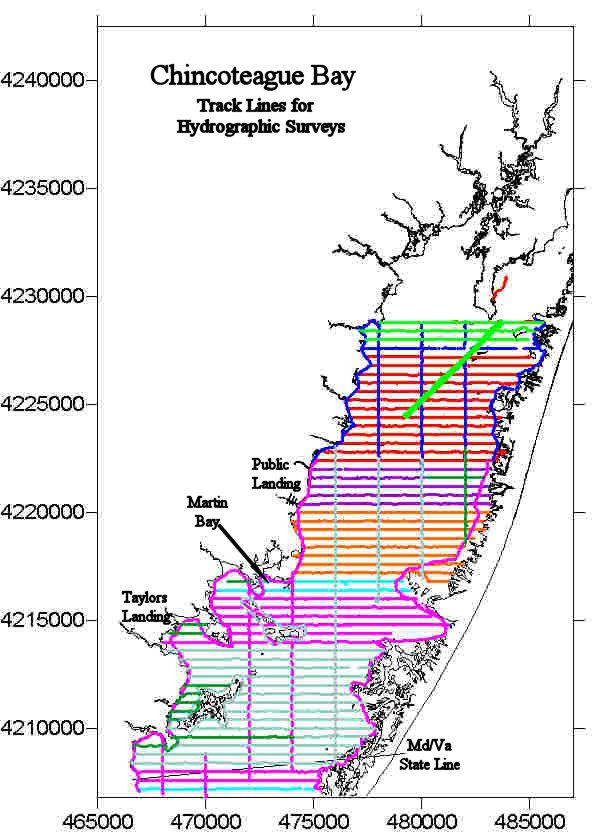
3 Study Area Chincoteague Bay, Maryland Size - 19,000 ha Microtidal lagoon Average Daily Range of 10 to 20 cm Polyhaline Salinity Range of 26 to 34 ppt Water Depth less than 2.5 m Largely undeveloped
4 Bathymetric Data A bathymetric data set collected by Maryland Geological Survey during summer 2003 We, then, obtained bathymetric data set for a small portion (4600 ha) of Chincoteague Bay near Public Landing during 2003 The MGS data set was evaluated for use in our study based on the smaller independent data set we had collected
5 Area of comparison
6 Avg. Difference 18.7 cm Points of comparison within 20m of each other
7 DEM of Chincoteague Bay

8 Identification of Subaqueous Landforms False Color Infrared Photographs Aids in the identification of washover fans and scour channels

9 Identification of Subaqueous Landforms False Color Infrared Photographs Aids in the identification of washover fans and scour channels Bathymetric Data Data set collected by Maryland Geological Survey
10 Identification of Subaqueous Landforms False Color Infrared Photographs Aids in the identification of washover fans and scour channels Bathymetric Data Slope Data set collected by Maryland Geological Survey

11 Identification of Subaqueous Landforms False Color Infrared Photographs Aids in the identification of washover fans and scour channels Bathymetric Data Slope Data set collected by Maryland Geological Survey Landscape Shape Geographical Relationships Proximity to barrier island, mainland, mouth of a tidal creek Depositional Environment Low-energy or high-energy

12 Subaqueous Landforms Ten landforms were identified Storm-surge washover fan flat Barrier Cove Paleo-flood tidal delta Storm-surge washover fan slope Lagoon bottom Mainland cove Submerged wave-cut headland Fluviomarine bottom Shoal Dredged Channel
13 Prior Soil Landscape Analysis Sinepuxent Bay, MD Soils and Landforms (from Demas) Mid-Bay Shoal: Sinepuxent soil series (Coarse-loamy, Typic Sulfaquents) Overwash Fans: Fenwick soil series (Typic Psammaquents) Barrier Island Flats: Tizzard soil series (Coarse-loamy, Sulfic Fluvaquents) Shallow Mainland Coves: Newport soil series (Typic Psammaquents) Deep Mainland Coves: Southpoint soil series (Fine-silty, Typic Sulfaquents) Transition Zones: Wallops soil series (Typic Psammaquents) Central Basin: No series available (Fine-silty, Typic Sulfaquents)
14 Prior Soil Landscape Analysis Ninigret Pond, RI Soils and Landforms (from Bradley and Stolt) Lagoon Bottom: Typic Hydraquents Storm-surge Washover Fan Flats: Typic Sulfaquents Flood-tidal Delta Flat: Typic Psammaquents Storm-surge Washover Fan Slope: Typic Fluvaquents Flood-tidal Delta Slope: Typic Fluvaquents Shoal: Typic Endoaquents Mainland Submerged Beach: Typic Endoaquents Barrier Coves: Typic Sulfaquents Mainland Shallow Coves: Typic Endoaquents Mid-lagoon Channel: Typic Endoaquents Mainland Coves: Thapto-histic Hydraquents


15 Student Workers Amanda Haase and Ross McAllen


16 Guest Scientists Mark Stolt Phil King

17 146 Full Pedon Descriptions 17 Partial Pedon Descriptions or Notes
18 Data Collected Profile descriptions Characterization Data on selected pedons Particle-size data Acid Volatile Sulfides and Chromium Reducible Sulfides Moist Incubation ph data Mineralogy (grain counting and x-ray diffraction) Salinity (electrical conductivity) Total C, Organic C, and Carbonate C Classified according to Soil Taxonomy 14 C dates obtained from 5 buried organic horizons
19 Morphological / Characterization Data Issues Field estimates of soil texture Sandy soils pretty good (more fine sands) Finer textures tendency to overestimate clay Field estimates of n-value Field estimates useful Lab calculations meaningless Moist incubation ph Allow incubation for longer than 8 weeks
20 Porewater Salinity Soils near the barrier island Storm-surge washover fan flats (CB01 and CB56), Barrier coves (CB10), Lagoon bottom (CB18 and CB79). No salinity trend with depth No decrease below 20 ppt Dashed lines show salinity range of Chincoteague Bay.
21 Porewater Salinity - Soils near the mainland 120 m from mainland 1200 m from mainland Salinity near the surface approached that of the overlying bay water Decreases with depth - attributed to groundwater influx Dashed lines represent the salinity range found within Chincoteague Bay.
22 Calcium carbonate determinations Low carbonate and moderate OC levels Standard Method Treat samples with with 5% sulfurous acid to dissolve carbonates Then run untreated and treated samples through high temperature (950C) combustion furnace Untreated samples = total Carbon (IC and OC) Treated samples = OC Difference = IC
23 Calcium carbonate determinations Problem with the method! Some (approx 7%) of OC was oxidized by sulfurous acid Led to overestimation of carbonates Can be serious if carbonates are low and OC moderate Non-calcareous Samples Tested
24 Theoretical Contribution of OC to CaCO 3 SS Washover Fan Flats % OC 7% of OC equiv of % CaCO3 g/kg CaCO Lagoon Bottom Lagoon Bottom
 CB01 25-100 cm 91.8 5.8 0.0 1.7 0.3 0.0 0.0 0.3 CB11 25-56 cm 66.")
25 Mineralogy of Selected Pedons Sample Control Section Quartz Feldspar Mica Opaque Garnet Amphibole Diatoms/Sponge Spicules Other % ( mm fraction) CB cm CB cm CB cm CB cm CB01 Storm-surge Washover Fan Flat CB11 Submerged Wave-cut Headland CB18 Lagoon Bottom CB58 Lagoon Bottom
26 Clay Mineralogy <2 um Sample Quartz Illite Chlorite Vermiculite Kaolinite Feldspars Amphiboles Cristobalite Jarosite CB11 Cg1, cm XX XXX XX X XX X x x x CB11 Cg2, cm XX XXX XX X XX X x x x CB18 Cg, 8-50 cm XX XXX XX X XX X x x CB18 Cg, cm XX XXX XX X XX X x x CB58 Cg1, cm XX XXX XX X XX X x x CB58 Cg2, cm XX XXX XX X XX X x x x: 0-5%; X: 5-10%; XX: 10-30%; XXX: 30-70%; and XXXX: >70%.
27 Classification of CB Soils Order Suborder Great Group Subgroup Family (PS) Class Histosols (2) Wassists (2) Sulfiwassists (2) Sapric Sulfiwassists (2) Entisols (144) Wassents (144) 1. Psammowassents (20) 1. Sulfic Psammowassents (20) 2. Sulfiwassents (124) 1. Haplic Sulfiwassents (26) 1. Sandy, Haplic Sulfiwassents (10) 2. Sandy over loamy, Haplic Sulfiwassents (1) 3. Coarse-loamy, Haplic Sulfiwassents (13) 4. Fine-loamy, Haplic Sulfiwassents (2) 5. Fine, Haplic Sulfiwassents (1) 2. Thapto-histic Sulfiwassents (6) 1. Coarse-silty, Thapto-histic Sulfiwassents (1) 2. Fine-loamy, Thapto-histic Sulfiwassents (2) 3. Fine-silty, Thapto-histic Sulfiwassents (2) 4. Fine, Thapto-histic Sulfiwassents (1) 3. Aeric Sulfiwassents (2) 1. Coarse-loamy, Aeric Sulfiwassents (2) 4. Fluventic Sulfiwassents (88) THESE ARE THE TYPICAL ONES! 1. Coarse-loamy, Fluventic Sulfiwassents (4) 2. Fine-loamy, Fluventic Sulfiwassents (9) 3. Fine-silty, Fluventic Sulfiwassents (74) 4. Fine, Fluvic Sulfiwassents (1) 3. Hydrowassents (1) 1. Sulfic Hydrowassents (1) 1. Coarse-silty, Sulfic Hydrowassents (1)
28 Eight new series proposed for use in CB Soil Series Name Truitt Tingles Cottman Figgs Tumagan Middlemoor Coards Thorofare Soil Classification Fine-silty, mixed, active, nonacid, mesic Fluventic Sulfiwassents Fine-silty, mixed, active, nonacid, mesic Fluventic Sulfiwassents Coarse-loamy, mixed, active, nonacid, mesic Haplic Sulfiwassents Fine-loamy, mixed, active, nonacid, mesic Fluventic Sulfiwassents Sapric Sulfiwassists Fine-silty, mixed, active, nonacid, mesic Fluventic Sulfiwassents Fine-silty, mixed, active, nonacid, mesic Fluventic Sulfiwassents Sandy, mixed, nonacid, mesic Haplic Sulfiwassents

29 Presence of buried organic horizons

30 2100 yr B.P yr B.P yr B.P.
31 2100 yr BP 2420 yrbp 3280 yr BP Long-Term Average Sea Level Rise: 1.25 mm yr -1

32 Soil Map 13 Soil Map Units Map Unit Symbol Series Water Depth

33
34 Composition of Map Units Evaluated Map Unit Coβ Ctγ Deα # Profiles Series (Total) 15 Coards Tingles Figgs Truitt Unnamed C 7 Cottman Thorofare Demas Sinepuxent 10 Demas Thorofare Cottman Tizzard # Observations (percentage) 11 (72%) 1 (7%) 1 (7%) 1 (7%) 1 (7%) 3 (43%) 2 (29%) 1 (14%) 1 (14%) 5 (50%) 2 (20%) 2 (20%) 1 (10%)
35 Use of SAS Data for SAV Habitat Assessment Soil Properties used to determine suitability for SAV (from an examination of the published literature) Sediment sulfide concentration Favorable < 5 g kg -1 Strongly Detrimental > 5 g kg -1 Organic carbon content Favorable < 30 g kg -1 Mildly Detrimental 30 to 70 g kg -1 Strongly Detrimental > 70 g kg -1 Texture Favorable S or LS (< 20% silt and clay) Mildly Detrimental SL, SCL, or L (20 to 50% silt and clay) Strongly Detrimental SiL, SiCL, CL, SiC, C (>50% silt and clay)
36 Favorable and Limiting Characteristics (example below done for each Map Unit) Soil Map Unit Favorable Properties Potentially Limiting Properties Overall Rating Coβ Organic Carbon content g/kg High levels of sulfides, SiCL or CL textures Severe Deα Organic Carbon content g/kg, low levels of sulfides (0.07 to 0.32 g/kg), sandy textures Slight

37

38 SAV Areal Coverage in CB VIMS Data


39

40 Suitability Map Tested based on past and present SAV growth patterns in Chincoteague Bay based on data sets provided by VIMS Used 2004 VIMS data and compared it to our suitability map
41 Total Hectares of SAV within Suitability Classes
42 Percentage of SAV for each Suitability Class
43 Conclusions of SAV Suitability Assessment The greatest proportion of SAV occurs on soils with slight limitations Our assessment based on the soil characteristics seemed to accurately reflect the SAV distribution in Chincoteague Bay The soils that were well suited for SAV growth and success include Demas soil series Thorofare soil series Cottman soil series Tizzard soil series Other factors Water depth, light pentration
44 Summary Using available (tested) bathymetry, a DEM was created. Subaqueous landforms were identified using all available information Morphological and characterization data were collected for soils within various landforms and landscape units Available subaqueous soil-landscape models for coastal lagoons were tested, applied and enhanced Eight new soil series were proposed A comprehensive soil resource inventory for Chincoteague Bay was developed The application of subaqueous soils data for the restoration of SAV was tested for CB
45 Conclusions The information collected during this study enriched the data set available on subaqueous soils at that time, and highlighted the importance of using subaqueous soil data in ecological studies This data set is now available for use in conjunction with other ecological studies for such purposes as identifying premium restoration sites for benthic flora and fauna and locating areas that are able to support engineering structures, etc.
LAA. Wassents that have sulfidic materials within 50 cm of the mineral soil surface. Sulfiwassents
 Wassents Wassents are subaqueous Entisols. Defined as Entisols that have a positive water potential at the soil surface for at least 90% of each day. These soils are the first suborder to classify out
Properties and Characterization of Subaqueous Soils
 Properties and Characterization of Subaqueous Soils Martin C. Rabenhorst Environmental Science and Technology University of Maryland Mark H. Stolt Natural Resources Science University of Rhode Island What
CZSS and Our Future. You don t know where to go unless you know where you ve come from Jan Mackinnon. Barret M. Wessel, Martin C.
 CZSS and Our Future You don t know where to go unless you know where you ve come from Jan Mackinnon Barret M. Wessel, Martin C. Rabenhorst University of Maryland Rhode River A 1000 acre subestuary of the
Subaqueous Soils A A New Frontier in Soil Survey. By Jim Turenne
 Subaqueous Soils A A New Frontier in Soil Survey By Jim Turenne http://nesoil.com.sas Subaqueous History Traditional soil survey conducted on land. Not a lot of work in wetlands and tidal marshes until
Subaqueous Soil-Landscape Relationships in a Rhode Island Estuary
 Subaqueous Soil-Landscape Relationships in a Rhode Island Estuary Michael P. Bradley* and Mark H. Stolt ABSTRACT 1941) support the inclusion of these substrates within Subaqueous soils occur from the lower
Subaqueous Landforms, Features, and Materials ( much content from Jim Turenne, NRCS, & Mark Stolt, URI )
") Subaqueous Landforms, Features, and Materials ( much content from Jim Turenne, NRCS, & Mark Stolt, URI ) 1) Discrete underwater features or geoforms (that commonly can support rooted plants), and adjacent
Subaqueous Landforms, Features, and Materials ( much content from Jim Turenne, NRCS, & Mark Stolt, URI ) 1) Discrete underwater features or geoforms (that commonly can support rooted plants), and adjacent
NCSS Soil Survey Updates & Intro to Coastal Zone and Subaqueous Soil Data
 NCSS Soil Survey Updates & Intro to Coastal Zone and Subaqueous Soil Data Jim Turenne, CPSS Assistant State Soil Scientist RI USDA NRCS http://nesoil.com/sas and www.mapcoast.org Digital Soils Data CT,
Curtis Monger USDA-NRCS Developments in Soil Taxonomy
 Curtis Monger USDA-NRCS Developments in Soil Taxonomy rice ANTHROPOCENE? Ca Curtis Monger USDA-NRCS Developments in Soil Taxonomy rice ANTHROPOCENE? Soil sustainability differs across the landscape. Ca
Lab 7: Sedimentary Structures
 Name: Lab 7: Sedimentary Structures Sedimentary rocks account for a negligibly small fraction of Earth s mass, yet they are commonly encountered because the processes that form them are ubiquitous in the
ΛTKINS. Applications of Regional Sediment Management Concepts in Texas Estuarine Restoration Projects. Riparian Workshop Fort Worth, October 17, 2012
 Juan C Moya, PhD., PG Coastal Planning and Restoration Applications of Regional Sediment Management Concepts in Texas Estuarine Restoration Projects Riparian Workshop Fort Worth, October 17, 2012 West
Landscapes & Hydric Soils Bruce Vasilas University of Delaware
 Landscapes & Hydric Soils Bruce Vasilas University of Delaware Hydric soils are defined as soils that formed under conditions of saturation, flooding, or ponding long enough during the growing season to
Sediment Management in the Coastal Bays
 Sediment Management in the Coastal Bays Introduction Need for ecosystem view of sediment management in Coastal Bays Island loss and restoration Navigation needs Habitat Trade offs Living Shoreline Requirements
Coastal Inlets Research Program US Army Corps of Engineers Engineering Research and Development Center
 Coastal Inlets Research Program US Army Corps of Engineers Engineering Research and Development Center Site of Moriches Inlet Nov. 1951 Julie Dean Rosati and Nicholas C. Kraus, CIRP Program Manager Shinnecock
A History of Subaqueous Soil Survey 2018 Coastal Zone Soil Survey (CZSS) Work Planning Conference Savannah, GA January 8 th 12 th, 2018
 Work Planning Conference Savannah, GA January 8 th 12 th, 2018") A History of Subaqueous Soil Survey 2018 Coastal Zone Soil Survey (CZSS) Work Planning Conference Savannah, GA January 8 th 12 th, 2018 Martin C. Rabenhorst Univ. of Maryland Mark H. Stolt Univ. of Rhode
A History of Subaqueous Soil Survey 2018 Coastal Zone Soil Survey (CZSS) Work Planning Conference Savannah, GA January 8 th 12 th, 2018 Martin C. Rabenhorst Univ. of Maryland Mark H. Stolt Univ. of Rhode
MEMORANDUM FOR SWG
 MEMORANDUM FOR SWG-2007-1623 Subject: Jurisdictional Determination (JD) for SWG-2007-1623 on Interdunal Wetlands Adjacent to Traditional Navigable Waters (TNWs) Summary The U.S. Environmental Protection
Soil Surveys. What are the most important properties to consider in a taxonomic system used for making a soil survey?
 Soil Surveys What are the most important properties to consider in a taxonomic system used for making a soil survey? What is a Soil Survey? Inventory of soil resources Delineation of spatial distribution
Introduction to Subaqueous Soils and MapCoast. James D. Turenne Assistant State Soil Scientist Rhode Island (The Ocean State) USDA-NRCS
 USDA-NRCS") Introduction to Subaqueous Soils and MapCoast. James D. Turenne Assistant State Soil Scientist Rhode Island (The Ocean State) USDA-NRCS Subaqueous History Traditional soil survey conducted on land. Not
Introduction to Subaqueous Soils and MapCoast. James D. Turenne Assistant State Soil Scientist Rhode Island (The Ocean State) USDA-NRCS Subaqueous History Traditional soil survey conducted on land. Not
Appendix I SOIL RATING CHART. (Storie soil Index Rating = factor A* factor B* factor C* factor X) FACTOR A- Rating on character of Physical Profile
 FACTOR A- Rating on character of Physical Profile") Appendix I SOIL RATING CHART (Storie soil Index Rating = factor A* factor B* factor C* factor X) FACTOR A- Rating on character of Physical Profile Sr. No Particulars Percentage I Soil on recent alluvial
Appendix I SOIL RATING CHART (Storie soil Index Rating = factor A* factor B* factor C* factor X) FACTOR A- Rating on character of Physical Profile Sr. No Particulars Percentage I Soil on recent alluvial
Paleo Lab #4 - Sedimentary Environments
 Paleo Lab #4 - Sedimentary Environments page - 1. CHARACTERISTICS OF SEDIMENT Grain size and grain shape: The sizes and shapes of sedimentary particles (grains) are modified considerably during their transportation
Depositional Environment
 Depositional Environment Sedimentary depositional environment describes the combination of physical, chemical and biological processes associated with the deposition of a particular type of sediment. Types
Bishopville Prong Study
 Bathymetric and Sediment Assessment in the Bishopville Prong of St. Martin River Darlene V. Wells, Richard A. Ortt, Jr., and Stephen Van Ryswick Funded by MCBP 2011-2012 Implementation Grant Objectives
HYDRIC SOILS. Background
 Background HYDRIC SOILS Soils consist of natural bodies that occur on a landform within a landscape and have properties that result from the integrated effects of climate and living organisms, acting on
Standards and Procedures for Site Specific Soil Mapping in Rhode Island. Pg 1
 Standards and Procedures for Site Specific Soil Mapping in Rhode Island Pg 1 The Task Take This and Create This The Task Take This and Create This and a Report Pg 2 How is this different than the RI Soil
Developing Soil Maps and Interpretations for Shallow Subtidal Habitats
 Developing Soil Maps and Interpretations for Shallow Subtidal Habitats James D. Turenne Assistant State Soil Scientist Rhode Island (The Ocean State) USDA-NRCS Narragansett Bay Estuary LNB Coastal Lagoons
Introduction to Soil Science and Wetlands Kids at Wilderness Camp
 Introduction to Soil Science and Wetlands Kids at Wilderness Camp Presented by: Mr. Brian Oram, PG, PASEO B.F. Environmental Consultants http://www.bfenvironmental.com and Keystone Clean Water Team http://www.pacleanwater.org
West Galveston Bay Regional Sediment Management Plan (An Eco-geomorphologic Approach)
") West Galveston Bay Regional Sediment Management Plan (An Eco-geomorphologic Approach) Juan Moya, Matthew Mahoney and Mike Smith Restore America s Estuaries Conference Tampa, FL, October 23, 2012 Atkins
West Galveston Bay Regional Sediment Management Plan (An Eco-geomorphologic Approach) Juan Moya, Matthew Mahoney and Mike Smith Restore America s Estuaries Conference Tampa, FL, October 23, 2012 Atkins
Page 1. Name:
 Name: 1) Which event is the best example of erosion? dissolving of rock particles on a limestone gravestone by acid rain breaking apart of shale as a result of water freezing in a crack rolling of a pebble
12- TOL MLRA Soil Survey Area Approximately 15,000,000 Acres
 !@ 12- TOL MLRA Soil Survey Area Approximately 15,000,000 Acres Office Location: Tolland, Connecticut Staff: Donald Parizek Acting Soil Survey Office Party Leader Jacob Isleib Soil Scientist Marissa Theve
Marine Sediments. Introductory Oceanography. Ray Rector: Instructor
 Marine Sediments Introductory Oceanography Ray Rector: Instructor Ocean Basins are Vast Sinks for Huge Amounts of Sediment from Numerous Different Sources Four Major Types of Seafloor Sediments 1. Lithogenous
RALPH SIMMONS STATE FOREST 2016 LAND MANAGEMENT PLAN EXHIBITS
 RALPH SIMMONS STATE FOREST 2016 LAND MANAGEMENT PLAN EXHIBITS EXHIBIT A Location Map Exhibit A EXHIBIT B Management Accomplishment Summary for RSSF EXHIBIT C Proximity to Other Public Lands Exhibit C
Chapter 5. The Sedimentary Archives
 Chapter 5 The Sedimentary Archives Factors affecting Sedimentary Characteristics 1. Tectonic setting 2. Physical, chemical, and biological processes in the depositional environment 3. Method of sediment
Sea-level Rise on Cape Cod: How Vulnerable Are We? Rob Thieler U.S. Geological Survey Woods Hole, MA
 Sea-level Rise on Cape Cod: How Vulnerable Are We? Rob Thieler U.S. Geological Survey Woods Hole, MA Outline Sea-level and coastal processes Past sea-level change Predictions for the future Coastal responses
Lecture 7: Introduction to Soil Formation and Classification
 Lecture 7: Introduction to Soil Formation and Classification Soil Texture and Color Analysis Lab Results Soil A: Topsoil from Prof. Catalano s backyard Soil B: Soil above beach at Castlewood State Park
Pre-Lab Reading Questions ES202
 ES202 The are designed to encourage students to read lab material prior to attending class during any given week. Reading the weekly lab prior to attending class will result in better grade performance
Lab 12 Coastal Geology
 Lab 12 Coastal Geology I. Fluvial Systems Hydrologic Cycle Runoff that flows into rivers = precipitation (rain and snowmelt) [infiltration (loss to groundwater) + evaporation (loss to atmosphere) + transpiration
Which map shows the stream drainage pattern that most likely formed on the surface of this volcano? A) B)
 B)") 1. When snow cover on the land melts, the water will most likely become surface runoff if the land surface is A) frozen B) porous C) grass covered D) unconsolidated gravel Base your answers to questions
1. When snow cover on the land melts, the water will most likely become surface runoff if the land surface is A) frozen B) porous C) grass covered D) unconsolidated gravel Base your answers to questions
Holocene evolution of Dahab coastline Gulf of Aqaba, Sinai Peninsula, Egypt 1
 Holocene evolution of Dahab coastline Gulf of Aqaba, Sinai Peninsula, Egypt 1 Magdy Torab* 2 * Prof. of Geomorphology, Department of Geography, Damanhour University, Egypt 3 E-mail: magdytorab@hotmail.com.
GEOLOGY MEDIA SUITE Chapter 5
 UNDERSTANDING EARTH, SIXTH EDITION GROTZINGER JORDAN GEOLOGY MEDIA SUITE Chapter 5 Sedimentation Rocks Formed by Surface Processes 2010 W.H. Freeman and Company Mineralogy of sandstones Key Figure 5.12
Weathering of Rocks. Weathering - Breakdown of rocks into pieces (sediment) 2 main types of weathering to rocks
 2 main types of weathering to rocks") Weathering of Rocks Weathering - Breakdown of rocks into pieces (sediment) 2 main types of weathering to rocks Mechanical weathering requires physical forces to break rocks into smaller pieces. Chemical
Weathering of Rocks Weathering - Breakdown of rocks into pieces (sediment) 2 main types of weathering to rocks Mechanical weathering requires physical forces to break rocks into smaller pieces. Chemical
Coastal Sediment Properties and Longshore Sediment Transport
 Coastal Sediment Properties and Longshore Sediment Transport Julie Rosati Julie.D.Rosati@erdc.usace.army.mil 601-634-3005 Coastal Planning Course Lesson #8 Tuesday 8:00-9:00 am CEM III-1, III-2 1. Coastal
3.1 GEOLOGY AND SOILS Introduction Definition of Resource
 3.1 GEOLOGY AND SOILS 3.1.1 Introduction 3.1.1.1 Definition of Resource The geologic resources of an area consist of all soil and bedrock materials. This includes sediments and rock outcroppings in the
Four Soil Orders on a Vermont mountaintop One-third of the world s soil orders in a 2500 square meter research plot
 Four Soil Orders on a Vermont mountaintop One-third of the world s soil orders in a 2500 square meter research plot Thomas R. Villars, Scott W. Bailey, Donald S. Ross 38% of world s soils are in these
GLOSSARY OF TERMS FOR SUBAQUEOUS SOILS, LANDSCAPES, LANDFORMS, AND PARENT MATERIALS OF ESTUARIES AND LAGOONS
 GLOSSARY OF TERMS FOR SUBAQUEOUS SOILS, LANDSCAPES, LANDFORMS, AND PARENT MATERIALS OF ESTUARIES AND LAGOONS Subaqueous Soils Subcommittee of the Standing Committee on NCSS Standards National Cooperative
The Marine Environment
 The Marine Environment SECTION 16.1 Shoreline Features In your textbook, read about erosional landforms, beaches, estuaries, longshore currents, and rip currents. For each statement below, write true or
CHAPTER 1 INTRODUCTION
 1 CHAPTER 1 INTRODUCTION 1.1 GENERAL Washover sandsheets are often found in low-lying coastal embayment s (Sedgwick and Davis 2003). Washover deposition of marine sand is usually attributed to storm activity
Primer on Coastal Erosion And Habitat Creation
 2 nd Regional Conference Dredging, Beach Nourishment & Bird Conservation Primer on Coastal Erosion And Habitat Creation Timothy Kana Ph.D Source: Newsday 1962 Photo by Kelsey Aerials 1978 Source: U Mass
Mapping, monitoring, and modeling: USGS Coastal and Marine Geology activities along the Northeast coast
 Mapping, monitoring, and modeling: USGS Coastal and Marine Geology activities along the Northeast coast Coastal and Marine Geology Program Woods Hole Coastal and Marine Science Center St. Petersburg Coastal
L.O: SLOWING STREAMS DEPOSIT (SORT) SEDIMENT HORIZONTALLY BY SIZE.
 SEDIMENT HORIZONTALLY BY SIZE.") L.O: SLOWING STREAMS DEPOSIT (SORT) SEDIMENT HORIZONTALLY BY SIZE. 1. Base your answer to the following question on the profile shown below, which shows the pattern of horizontal sorting produced at a
L.O: SLOWING STREAMS DEPOSIT (SORT) SEDIMENT HORIZONTALLY BY SIZE. 1. Base your answer to the following question on the profile shown below, which shows the pattern of horizontal sorting produced at a
Weathering and Erosion
 Have you ever looked at the land around you and wondered how it was shaped? The geologic features that help define the world are still being shaped by the natural processes of weathering, erosion, and
Soil Morphology and Stratigraphy on an Erosional Footslope: Dickinson Experiment Station in Western North Dakota
 Soil Morphology and Stratigraphy on an Erosional Footslope: Dickinson Experiment Station in Western North Dakota By D. Claypool, D. G. Hopkins, and J. L. Richardson ABSTRACT A first order soil survey of
NCSS/NRCS Updates & New Horizon Designation for ^Anthropogenic Soils. Jim Turenne, CPSS Assistant State Soil Scientist RI USDA NRCS
 NCSS/NRCS Updates & New Horizon Designation for ^Anthropogenic Soils Jim Turenne, CPSS Assistant State Soil Scientist RI USDA NRCS http://nesoil.com NCSS / NRCS Updates Major reorganization of the NCSS
Name: Which rock layers appear to be most resistant to weathering? A) A, C, and E B) B and D
 A, C, and E B) B and D") Name: 1) The formation of soil is primarily the result of A) stream deposition and runoff B) precipitation and wind erosion C) stream erosion and mass movement D) weathering and biological activity 2)
Name: 1) The formation of soil is primarily the result of A) stream deposition and runoff B) precipitation and wind erosion C) stream erosion and mass movement D) weathering and biological activity 2)
The Marine Environment
 The Marine Environment SECTION 16.1 Shoreline Features In your textbook, read about erosional landforms, beaches, estuaries, longshore currents, and rip currents. For each statement below, write or. 1.
4. The map below shows a meandering stream. Points A, B, C, and D represent locations along the stream bottom.
 1. Sediment is deposited as a river enters a lake because the A) velocity of the river decreases B) force of gravity decreases C) volume of water increases D) slope of the river increases 2. Which diagram
Ch 10 Deposition Practice Questions
 1. Base your answer to the following question on the data table below. Six identical cylinders, A through F, were filled with equal volumes of sorted spherical particles. The data table shows the particle
Module/Unit: Landforms Grade Level: Fifth
 Module/Unit: Landforms Grade Level: Fifth PA Academic Standards for Science and Technology and Environment and Ecology: 3.1.7.B Describe the use of models as an application or scientific or technological
Geology and New England Landscapes
 Geology and New England Landscapes Jim Turenne, CPSS USDA-NRCS Warwick, RI. http://nesoil.com Why Geology? Provides the big picture of site conditions. Major part of soil formation (parent material and
Appendix O. Sediment Transport Modelling Technical Memorandum
 Appendix O Sediment Transport Modelling Technical Memorandum w w w. b a i r d. c o m Baird o c e a n s engineering l a k e s design r i v e r s science w a t e r s h e d s construction Final Report Don
Ecoregions Glossary. 7.8B: Changes To Texas Land Earth and Space
 Ecoregions Glossary Ecoregions The term ecoregions was developed by combining the terms ecology and region. Ecology is the study of the interrelationship of organisms and their environments. The term,
Introduction to the Hydrogeomorphic (HGM) Classification System
 Classification System") Introduction to the Hydrogeomorphic (HGM) Classification System Objectives The Student Will be Able to: Define the 7 HGM Classes List the 3 Parameters That Define HGM Classes List the Major Water Budget
Introduction to the Hydrogeomorphic (HGM) Classification System Objectives The Student Will be Able to: Define the 7 HGM Classes List the 3 Parameters That Define HGM Classes List the Major Water Budget
What is weathering and how does it change Earth s surface? Answer the question using
 7 th Grade Lesson What is weathering and how does it change Earth s surface? Answer the question using the sentence frame. You have 4 minutes. Weathering is. This changes the Earth s surface because. 1
Maggie Payne Jim Turenne
 Maggie Payne Jim Turenne USDA-NRCS 60 Quaker Lane, Suite 46 Warwick, RI. 02886 401-822-8832 maggie.payne@ri.usda.gov U.S. Department of Agriculture 1935: Soil Conservation Service (SCS) Natural Resources
Rivers T. Perron
 1 Rivers T. Perron 12.001 After our discussions of large-scale topography, how we represent topography in maps, and how topography interacts with geologic structures, you should be frothing at the mouth
Coastal and Marine Ecological Classification Standard (CMECS)
") Coastal and Marine Ecological Classification Standard (CMECS) Mark Finkbeiner NOAA Coastal Services Center Presented at the International Workshop on Seabed Mapping Methods and Technology 18 October 2012
Coastal and Marine Ecological Classification Standard (CMECS) Mark Finkbeiner NOAA Coastal Services Center Presented at the International Workshop on Seabed Mapping Methods and Technology 18 October 2012
Erosion and Deposition along Rivers and Seashores - Part 1: Modeling in the Classroom
 Erosion and Deposition along Rivers and Seashores - Part 1: Modeling in the Classroom Lesson Focus: Erosion and Deposition Learning Objectives: Students will learn to recognize landforms found on Earth.
 UNIT DESCRIPTIONS: Artificial Fill, Undocumented (Afu): Locally derived sandy silt and silty sand, locally with clay and varying amounts of gravel and man-made debris. Abundant concrete rubble, in places
GLG Chapter 7 Sedimentary Environments & Rocks
 GLG 101 - Chapter 7 Sedimentary Environments & Rocks Name Note, Oct 11: I ll be writing this study sheet over the next few days. Each day I will add questions until the entire chapter is done, hopefully
Soil Taxonomy Classification Osage County, Kansas. Web Soil Survey National Cooperative Soil Survey
 95 45' 5'' W Soil Taxonomy Classification Osage County, Kansas 95 44' 3'' W 260300 260400 260500 260600 260700 260800 260900 261000 261100 261200 261300 261400 261500 261600 261700 38 33' 4'' N 38 32'
Sediment and sedimentary rocks Sediment
 Sediment and sedimentary rocks Sediment From sediments to sedimentary rocks (transportation, deposition, preservation and lithification) Types of sedimentary rocks (clastic, chemical and organic) Sedimentary
Assembling information to develop ecological site and state and transition concepts. Brandon Bestelmeyer, Jornada Experimental Range, Las Cruces, NM
 Assembling information to develop ecological site and state and transition concepts Brandon Bestelmeyer, Jornada Experimental Range, Las Cruces, NM Concepts: Ecological site: division of the landscape
The boundary between two formations (or any distinct layers) is called a contact. Sedimentary rocks cover 75% of continents.
 is called a contact. Sedimentary rocks cover 75% of continents.") Sedimentary Rocks Sedimentary rocks form at the Earth s surface through interactions of the hydrologic system and the crust. Fortunately, many of these processes are in operation today, and geologists
Sedimentary Rocks Sedimentary rocks form at the Earth s surface through interactions of the hydrologic system and the crust. Fortunately, many of these processes are in operation today, and geologists
Practice Questions for Lecture 5 Geology 1200
 Practice Questions for Lecture 5 Geology 1200 Use these questions to test your knowledge of Lecture5. The exams will be similar in format, except that they will deal with more than one chapter, and will
MINERAL CONTENT AND DISTRIBUTION AS INDEXES OF WEATHERING IN THE OMEGA AND AHMEEK SOILS OF NORTHERN WISCONSIN
 MINERAL CONTENT AND DISTRIBUTION AS INDEXES OF WEATHERING IN THE OMEGA AND AHMEEK SOILS OF NORTHERN WISCONSIN By L. D. WHITTIG 1 AND M. L. JACKSON University of Wisconsin, Madison, Wisconsin ABSTRACT Quantitative
Regional-scale understanding of the geologic character and sand resources of the Atlantic inner continental shelf, Maine to Virginia
 Regional-scale understanding of the geologic character and sand resources of the Atlantic inner continental shelf, Maine to Virginia Workshop on Dredging, Beach Nourishment and Bird Conservation Atlantic
L7/ Historical Perspec=ve, Deltas
 Colin Woodroffe (2002) Coasts: Form, Process and Evolu=on, Outline of Chapter 7: L7/1 L7/2 7.1. Historical Perspec=ve, 7.1.1. Deltas Herodotus (450, B.C.) delta = Shape of Nile River Delta = Δ Gilbert
GY 402: Sedimentary Petrology
 UNIVERSITY OF SOUTH ALABAMA GY 402: Sedimentary Petrology Lecture 13: Immature Siliciclastic Sedimentary Environments Alluvial Fans, Braided Streams Instructor: Dr. Douglas W. Haywick Last Time Immature
RESULTS FROM THE TEXAS COASTAL SEDIMENT SOURCES: A GENERAL EVALUATION STUDY
 RESULTS FROM THE TEXAS COASTAL SEDIMENT SOURCES: A GENERAL EVALUATION STUDY JUAN MOYA KELSEY CALVEZ CRIS WEBER ANTHONY RISKO *KEVIN FRENZEL FREESE AND NICHOLS, INC. COASTAL AND WATERWAYS GROUP OBJECTIVES
Australian Coastal Councils Conference
 Australian Coastal Councils Conference 11 March 2015 Estimating Future Coastal Inundation and Erosion Hazards Dr Andrew McCowan Dr Christine Lauchlan-Arrowsmith Warwick Bishop Background Victorian Future
Chapter 2. Regional Landscapes and the Hydrologic Cycle
 Chapter 2. Regional Landscapes and the Hydrologic Cycle W. Lee Daniels Department of Crop and Soil Environmental Sciences, Virginia Tech Table of Contents Introduction... 23 Soils and landscapes of the
Jim Turenne. Soils on Social Media
 Jim Turenne USDA-NRCS 60 Quaker Lane, Suite 46 Warwick, RI. 02886 401-822-8832 Jim.turenne@ri.usda.gov Soils on Social Media www.twitter.com/soilsne www.fb.com/soilsne www.nesoil.com U.S. Department of
An overview of USGS Hurricane Sandy Supplemental Studies along the Delmarva Peninsula
 An overview of USGS Hurricane Sandy Supplemental Studies along the Delmarva Peninsula Neil K. Ganju, Laura L. Brothers, Nathaniel G. Plant, Christopher G. Smith, E. Robert Thieler Coastal and Marine Geology
CHEMICAL, PHYSICAL, AND MINERALOGICAL PROPERTIES OF CERTAIN SOIL PROFILES IN THE LOWER MISSISSIPPI DELTA B. N. DRISKELL ABSTRACT
 CHEMICAL, PHYSICAL, AND MINERALOGICAL PROPERTIES OF CERTAIN SOIL PROFILES IN THE LOWER MISSISSIPPI DELTA B. N. DRISKELL Louisiana State University ABSTRACT The soils of the lower Mississippi Delta are
Watershed concepts for community environmental planning
 Purpose and Objectives Watershed concepts for community environmental planning Dale Bruns, Wilkes University USDA Rural GIS Consortium May 2007 Provide background on basic concepts in watershed, stream,
Classification of geodiversity in a natural tidal inlet system based on topobathymetric LiDAR data
 Classification of geodiversity in a natural tidal inlet system based on topobathymetric LiDAR data MSc Thesis, September 2015 Mikkel Skovgaard Andersen DANCORE, 2/10-2015, Copenhagen Content 1. Motivation
Chapter 17. Ocean and Coastal Processes
 Chapter 17 Ocean and Coastal Processes Ocean Basins and Plates Ocean Basins Ocean Basins are profoundly different from the continents. Ocean crust is thin and dense and young. New ocean crust is generated
Soil Development. Soils Sustain Life
 Soil Development Soils Sustain Life Right off the Bat!! A soil is not a geologic deposit, it is a product of in situ weathering. Engineers, archaeologists, and others have learned that anything that is
Procedure for Determining Near-Surface Pollution Sensitivity
 Procedure for Determining Near-Surface Pollution Sensitivity Minnesota Department of Natural Resources Division of Ecological and Water Resources County Geologic Atlas Program March 2014 Version 2.1 I.
Custom Soil Resource Report for Forrest County, Mississippi
 United States Department of Agriculture Natural Resources Conservation Service A product of the National Cooperative Soil Survey, a joint effort of the United States Department of Agriculture and other
Geology 252, Historical Geology, California State University, Los Angeles - professor: Dr. Alessandro Grippo
 LAB # 1 - CLASTIC ROCKS Background: - Mechanical and Chemical Weathering - Production of Clastic Sediment - Classification of Sediment according to size: Gravel, Sand, Silt, Clay - Erosion, Transportation
Chapter 6 Pages of Earth s Past: Sedimentary Rocks
 Chapter 6 Pages of Earth s Past: Sedimentary Rocks Introduction! Drilling into the bottom of the North Sea, we encounter: " Soft mud and loose sand, silt, pebbles, and shells. Then: " Similar materials
Geol 117 Lecture 18 Beaches & Coastlines. I. Types of Coastlines A. Definition:
 I. Types of Coastlines A. Definition: 1. Shore = narrow zone where ocean meets land (e.g. beach) 2. Coast is a broad area where both ocean and land processes act a. Includes onshore marshes, dunes, sea
Ocean and Coastal Processes. Ocean Basins. Chapter 20. Ocean Basins and Plates. Ocean Terms. Sea Arch Bay-mouth Bar Spit Tombolo Coast.
 Chapter 20 Ocean Basins and Plates Ocean and Coastal Processes Tide Wave Height Length Period Base Refraction Tsunami Beach Sea stack Ocean Terms Sea Arch Bay-mouth Bar Spit Tombolo Coast Emergent Submergent
ST. LUCIE COUNTY, FLORIDA
 ST. LUCIE COUNTY, FLORIDA COASTAL STORM RISK MANAGEMENT PROJECT DRAFT INTEGRATED FEASIBILITY STUDY AND ENVIRONMENTAL ASSESSMENT APPENDIX D Geotechnical APRIL 2016 TABLE OF CONTENTS 1 Background... 3 1.1
High Resolution Numerical Models of Tidal Marshes in the Delaware Bay
 High Resolution Numerical Models of Tidal Marshes in the Delaware Bay Ramona Stammermann Dept. of Civil, Architectural & Environmental Engineering, Drexel University, Philadelphia, PA Michael Piasecki
Soil Formation. Lesson Plan: NRES B2-4
 Soil Formation Lesson Plan: NRES B2-4 1 Anticipated Problems 1. What are five different factors that affect soil formation? 2. What are some different types of parent material that affect soils? 3. What
Permafrost-influenced Geomorphic Processes
 Section 4 Permafrost-influenced Geomorphic Processes Geomorphic processes vary greatly among ecoregions in northern Alaska, extending from the Beaufort Sea coast to the Brooks Range (Figure 4.1). Regional
Lab Exercise 3: Geology, Soils and Archaeological Site Settings of Rift Valleys
 Name: Lab Exercise 3: Geology, Soils and Archaeological Site Settings of Rift Valleys Objectives: Grading The objectives of this lab are to: 1. To reinforce through exercises the sedimentary and stratigraphic
3.3 CLIMATE, GEOLOGY, TOPOGRAPHY, AND SOILS CLIMATE GEOLOGY TOPOGRAPHY
 3.3 CLIMATE, GEOLOGY, TOPOGRAPHY, AND SOILS This section describes the climate, geology, topography, and soil resource characteristics of the Yolo Bypass Wildlife Area (Wildlife Area). Agricultural soil
Mark H. Horwitz Ping Wang PhD Coastal Research Laboratory, School of Geosciences University of South Florida
 Mark H. Horwitz Ping Wang PhD Coastal Research Laboratory, School of Geosciences University of South Florida American Shore & Beach Preservation Association 2015 National Coastal Conference, New Orleans,
EPS 50 Lab 4: Sedimentary Rocks
 Name: EPS 50 Lab 4: Sedimentary Rocks Grotzinger and Jordan, Chapter 5 Introduction In this lab we will classify sedimentary rocks and investigate the relationship between environmental conditions and