Permeable Treatment Wall Project
|
|
|
- Jade Cannon
- 5 years ago
- Views:
Transcription
1 West Valley Demonstration Project West Valley Environmental Services Permeable Treatment Wall Project 20614_1 John Chamberlain May 26, 2010 West Valley Citizen Task Force Meeting West Valley Demonstration Project South Plateau North Plateau 20614_2

2 Valley Cross Section North Plateau On the North Plateau, feet of relatively permeable material occurs above a confining (low permeability) clay layer Precipitation that infiltrates in this area moves downward to the clay layer and then downgradient to the northeast The groundwater surfaces at the edge of the plateau as seeps or springs 20614_3 Background Groundwater Plume In late 1993, contaminated groundwater surfaced in ditches on the North Plateau Geoprobe investigation (small diameter wells) was conducted in the summer of 1994 to determine nature and extent of contamination Contaminant involved is Strontium-90 (Sr- Ditches 90) and has been attributed to a process line(s) leak(s) during reprocessing Slope in the 1970s Open Swale Area of leading edge of Sr-90 plume 20614_4
3 Background - Groundwater Plume Sr-90 Plume Swamp Ditch 20614_5 Background Groundwater Plume Pump and treat system installed in the fall of 1995 to mitigate surfacing and off-site movement of contaminated groundwater Between 1996 and 1998 surface water drainage changes made north of the Main Plant Pilot PTW installed in 1999 Detailed evaluation of the pilot PTW completed in pumping wells location pilot PTW location 20614_6


4 2007 Diagram of Plume 20614_7 Alternatives Evaluated Alternative 1 Maintain Current Approach Alternative 2 Interceptor Trench Drain Alternative 3 Groundwater Extraction Wells Alternative 4 Far Downgradient Interceptor Trench Drain Alternative 5 Far Downgradient Groundwater Extraction Wells Alternative 6 In-situ Plume Treatment with Passive PTW Alternative 6A In-situ Plume Treatment with Active PTW Alternative 7 Far Downgradient In-situ Plume Treatment with Passive PTW Leading edge of Sr-90 plume Far Downgradient 20614_8


 Refined")
5 Alternative 6 Selected for Evaluation In-situ Plume Treatment with Passive PTW Road Pump and Treat Pilot PTW Note: 2007 concept for PTW location/dimensions was based on available field data _9 Leading Edge Characterization Evolving Understanding of Plume Configuration Placed more than 80 borings and microwells ( ) Characterized geology, hydrogeology, geochemistry in area of proposed PTW (10,000 pci/l area) Refined understanding of Sr-90 distribution to northern edge of plateau 20614_10


 using simulated groundwater; Sr-88 surrogate for SR-90,")
 Non-radioactive column")
6 Hydrogeoligic Cross-Section Along PTW Alignment 20614_11 Laboratory Testing of Zeolites Two natural zeolites high in clinoptilolite content are being tested through the University at Buffalo (UB) Grain size analysis Permeability mineral composition Cation exchange capacity West Valley strontium specific removal (column tests) Non-radioactive columns (at UB) using simulated groundwater; Sr-88 surrogate for SR-90, 5 key cations (Na, Ca, K, Mg, Sr) Radioactive columns (at WVDP) using actual North Plateau groundwater (~50,000 pci/l) Non-radioactive column tests 20614_12


7 Bear River Zeolite - Idaho Exposed section of zeolite Truck being loaded with one ton bags of zeolite (20 bags /truck) Bear River Mine 20614_13 PTW Location PTW Dimensions ~800 feet long ~3 feet wide feet deep 20614_14
 in one operation Trencher allows installation of PTW without use of support piles or in-trench slurry")

 Equipment access, operation, decontamination Soil management Surface water drainage")
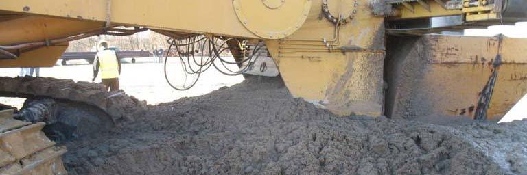
8 PTW Installation PTW installation is planned to be done with a continuous, one-pass trencher that cuts a trench and fills with media (zeolite) in one operation Trencher allows installation of PTW without use of support piles or in-trench slurry avoiding possible impacts to permeability at soil-zeolite interface Note: Trencher limited to approximately 30 foot excavation with 3-foot wide trench Trencher equipped with 25 bar, 2 wide cutter 20614_15 Concept to Design to Installation Following have been established PTW location Media (zeolite) to use Installation approach (one-pass trencher) Focus now on installation (construction) Equipment access, operation, decontamination Soil management Surface water drainage Contingencies 20614_16


9 Alignment Borings 20614_17 PTW Installation 20614_18

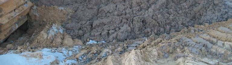

10 PTW Installation 20614_19 PTW Installation 20614_20
11 PTW Installation Projections (approximate) 800-feet long, 3-feet wide, feet deep 75,000 cubic feet of soil excavated 2,000 metric tons of zeolite 20614_21 Status as of May 26, 2010 Formal design done First shipment of zeolite received in May with shipments planned through mid-summer Work focused on requests for proposals for trencher and general contractor Site preparation targeted to begin in mid- to late summer PTW installation (trenching) fall _22
Pressure Grouting of Fractured Bedrock to Control Acid Mine Drainage
 WATER RESOURCES AT RISK May 14-18, 1995 Denver American Institute of Hydrology Pressure Grouting of Fractured Bedrock to Control Acid Mine Drainage S. A. Effner, G. D. Vandersluis, and V. Straskraba Hydro-Geo
Background. Valley fills Sites in the Area. Construction over Mine Spoil Fills
 Construction over Mine Spoil Fills Wayne A. Karem, PhD, PE, PG, D.GE 2014 KSPE Annual Conference Background Strip mining; mountaintop and contour mining Creates huge quantities of mine spoil The mine spoil
10. GEOTECHNICAL EXPLORATION PROGRAM
 Geotechnical site investigations should be conducted in multiple phases to obtain data for use during the planning and design of the tunnel system. Geotechnical investigations typically are performed in
Soils, Hydrogeology, and Aquifer Properties. Philip B. Bedient 2006 Rice University
 Soils, Hydrogeology, and Aquifer Properties Philip B. Bedient 2006 Rice University Charbeneau, 2000. Basin Hydrologic Cycle Global Water Supply Distribution 3% of earth s water is fresh - 97% oceans 1%
How & Where does infiltration work? Summary of Geologic History Constraints/benefits for different geologic units
 June 26, 2007: Low Impact Development 1 Associated Earth Sciences, Inc. Associated Earth Sciences, Inc. Presented by: Matthew A. Miller, PE April 24, 2012 How & Where does infiltration work? Summary of
Appendix D. Sediment Texture and Other Soil Data
 5 6 7 8 Appendix D. Sediment Texture and Other Soil Data This appendix describes the sediment texture of the aquifer system in the Restoration Area. The contents of this appendix describe the: Importance
Laboratory Exercise #3 The Hydrologic Cycle and Running Water Processes
 Laboratory Exercise #3 The Hydrologic Cycle and Running Water Processes page - 1 Section A - The Hydrologic Cycle Figure 1 illustrates the hydrologic cycle which quantifies how water is cycled throughout
Table 5-1 Sampling Program Summary for Milltown Ford Avenue Redevelopment Area, NJ.
 Table 5- Sampling Program Summary for Milltown Ford Avenue Redevelopment Area, NJ. Transformer Pads (9 pads: PAD 9) Evaluate if PCBs presently exist in soils adjacent to, and/or beneath the transformer
CHAPTER 7 GEOLOGY AND SOILS
 CHAPTER 7 GEOLOGY AND SOILS 7.1 General Geology of the Area Based on the Geological map compiled by Cornec (2002) the area consists of Miocene/Pleistocene deposits as seen in figure 7.1. These are geologically
Enhanced Characterization of the Mississippi River Valley Alluvial Aquifer Using Surface Geophysical Methods
 Photo by Shane Stocks, U.S. Geological Survey Enhanced Characterization of the Mississippi River Valley Alluvial Aquifer Using Surface Geophysical Methods Presented by Ryan F. Adams US Geological Survey
Soil Sampling Results Former Truck Maintenance Garage
 Soil Sampling Results Former Truck Maintenance Garage Maine Yankee Decommissioning Project Corrective Measures Study May 2004 Prepared for: Maine Yankee 321 Old Ferry Road, Bailey Point Wiscasset, ME 04578
Betsy Stevenson and Allison Mohrs (Skagit County Planning and Development Services) Jenny Baker, The Nature Conservancy
 Jenny Baker, The Nature Conservancy") TC Fisher Slough Final Design and Permitting Subject: Well Review Memorandum To: From: Betsy Stevenson and Allison Mohrs (Skagit County Planning and Development Services) Jenny Baker, The ature Conservancy
TC Fisher Slough Final Design and Permitting Subject: Well Review Memorandum To: From: Betsy Stevenson and Allison Mohrs (Skagit County Planning and Development Services) Jenny Baker, The ature Conservancy
Karst Topography In order to understand karst topography we must first have a basic understanding of the water cycle, the formation of limestone (carb
 Karst Topography The formation of caves and other associated features in limestone bedrock is called karst topography. Limestone, a sedimentary rock made mostly of the mineral calcite and small amounts
IAEA SAFETY STANDARDS Geotechnical Aspects of Site Evaluation and Foundations in NPPs, NS-G-3.6
 IAEA SAFETY STANDARDS Geotechnical Aspects of Site Evaluation and Foundations in NPPs, NS-G-3.6 Regional Workshop on Volcanic, Seismic, and Tsunami Hazard Assessment Related to NPP Siting Activities and
MICRO TO MACRO ARE UK LINEAR INFRASTRUCTURE GI S SUITABLE FOR INVESTIGATING MASS SOIL PROPERTY CHARACTERISTICS?
 MICRO TO MACRO ARE UK LINEAR INFRASTRUCTURE GI S SUITABLE FOR INVESTIGATING MASS SOIL PROPERTY CHARACTERISTICS? Ben Gilson - Arup 1 OUTLINE 1. Context why linear infrastructure? 2. Geotechnical challenges
How Much Can it Cost to Remediate a Large Landslide? Theme Session No. 10 at GSA Cordilleran Section Meeting, May 13-15, 2002
 How Much Can it Cost to Remediate a Large Landslide? Theme Session No. 10 at GSA Cordilleran Section Meeting, May 13-15, 2002 Author and Presenter: Charles M. Hammond, CEG, Landslide Technology, 10250
THE MINISTRY OF ENERGY AND ENERGY INDUSTRIES MINERALS DIVISION MINE DESIGN TEMPLATE OPERATOR NAME: OPERATOR ADDRESS: PHONE NUMBER: FACSIMILE:
 THE MINISTRY OF ENERGY AND ENERGY INDUSTRIES MINERALS DIVISION MINE DESIGN TEMPLATE 1.0 GENERAL INFORMATION OPERATOR NAME: OPERATOR ADDRESS: PHONE NUMBER: FACSIMILE: NAME OF CONTACT: CELLULAR PHONE: EMAIL
Illinois Drought Update, December 1, 2005 DROUGHT RESPONSE TASK FORCE Illinois State Water Survey, Department of Natural Resources
 Illinois Drought Update, December 1, 2005 DROUGHT RESPONSE TASK FORCE Illinois State Water Survey, Department of Natural Resources For more drought information please go to http://www.sws.uiuc.edu/. SUMMARY.
This report was prepared by Klohn Crippen Consultants Ltd. for Alberta Transportation Central Region under Contract No. CE053/2000.
 Alberta Transportation Central Region #401, 4902 51 Street Red Deer, Alberta T4N 6K8 June 7, 2002 Mr. Melvin Mayfield, P.Eng. Project Engineer Dear Mr. Mayfield: Central Region Landslide Assessment Site
6.1 Water. The Water Cycle
 6.1 Water The Water Cycle Water constantly moves among the oceans, the atmosphere, the solid Earth, and the biosphere. This unending circulation of Earth s water supply is the water cycle. The Water Cycle
February 22, 2011 Picatinny Team Meeting Edison, New Jersey
 February 22, 2011 Picatinny Team Meeting Edison, New Jersey Updated Groundwater Model and Remedies Mid-Valley Groundwater (PICA 204) February 22, 2011 Imagine the result Review of 2009 2010 Field Program
PHASE 1 STUDIES UPDATE EROSION WORKING GROUP
 PHASE 1 STUDIES UPDATE EROSION WORKING GROUP Presented By MICHAEL WOLFF, PG Erosion Study Area Manager West Valley Demonstration Project Quarterly Public Meeting February 24, 2016 OUTLINE Study 1 Terrain
Prentice Hall EARTH SCIENCE
 Prentice Hall EARTH SCIENCE Tarbuck Lutgens Running Water and Groundwater Running Water The Water Cycle Water constantly moves among the oceans, the atmosphere, the solid Earth, and the biosphere. This
the Quarrying Industry Dewatering and the Quarrying Industry the Quarrying Industry
 Dewatering and the Quarrying Industry Dewatering and Dewatering and the Quarrying Industry the Quarrying Industry Les Brown Eugene P. Daly John Kelly Objectives 1) To present a summary of water management
Hydrogeological Assessment for Part of Lots 2 and 3, Concession 5, Township of Thurlow, County of Hastings 1.0 INTRODUCTION. 1.
 February 10,2017 25506400 Ontario Ltd. Foxboro, ON Attention: Brad Newbatt Re: Hydrogeological Assessment for Part of Lots 2 and 3, Concession 5, Township of Thurlow, County of Hastings 1.0 INTRODUCTION
A Homeowner s Guide to Landslides for Washington and Oregon
 Protect Your Home and Property 1 A Homeowner s Guide to Landslides for Washington and Oregon Washington Geological Survey and Oregon Department of Geology and Mineral Industries LANDSLIDES ARE ONE OF THE
CE 240 Soil Mechanics & Foundations Lecture 5.2. Permeability III (Das, Ch. 6) Summary Soil Index Properties (Das, Ch. 2-6)
 Summary Soil Index Properties (Das, Ch. 2-6)") CE 40 Soil Mechanics & Foundations Lecture 5. Permeability III (Das, Ch. 6) Summary Soil Index Properties (Das, Ch. -6) Outline of this Lecture 1. Getting the in situ hydraulic conductivity 1.1 pumping
CE 40 Soil Mechanics & Foundations Lecture 5. Permeability III (Das, Ch. 6) Summary Soil Index Properties (Das, Ch. -6) Outline of this Lecture 1. Getting the in situ hydraulic conductivity 1.1 pumping
Freshwater. 1. The diagram below is a cross-sectional view of rain falling on a farm field and then moving to the water table.
 Name: ate: 1. The diagram below is a cross-sectional view of rain falling on a farm field and then moving to the water table. 3. Which conditions produce the most surface water runoff? A. steep slope,
PEACE RIVER EAST HILL - HWY 2:60 (PH2) SELECT PHOTOGRAPHS August 22, 2007 File: Photo E003. Station May 2007
 SELECT PHOTOGRAPHS August 22, 2007 File: Photo E003. Station May 2007") Photo E003 0+000 Viewing looking upslope at Site 4 from highway. Conditions unchanged from 2006. Photo E018 0+000 Localized erosion within road fill on upslope side of highway. Photo E022 0+250 Looking
Photo E003 0+000 Viewing looking upslope at Site 4 from highway. Conditions unchanged from 2006. Photo E018 0+000 Localized erosion within road fill on upslope side of highway. Photo E022 0+250 Looking
June 9, R. D. Cook, P.Eng. Soils Engineer Special Services Western Region PUBLIC WORKS CANADA WESTERN REGION REPORT ON
 PUBLIC WORKS CANADA WESTERN REGION REPORT ON GEOTECHNICAL INVESTIGATION PROPOSED MARTIN RIVER BRIDGE MILE 306.7 MACKENZIE HIGHWAY Submitted by : R. D. Cook, P.Eng. Soils Engineer Special Services Western
Materials. Use materials meeting the following.
 208.01 Section 208. SOIL EROSION AND SEDIMENTATION CONTROL 208.01 Description. Install and maintain erosion and sedimentation controls to minimize soil erosion and to control sedimentation from affecting
University of Pretoria. Matthys Dippenaar and Louis van Rooy Engineering Geology and Hydrogeology, Geology Department July 2017, Livingstone, Zambia
 University of Pretoria Contributions to the Characterisation of the Vadose Zone f or Hydrogeological and Geotechnical Applications Matthys Dippenaar and Louis van Rooy Engineering Geology and Hydrogeology,
Slope Stability Evaluation Ground Anchor Construction Area White Point Landslide San Pedro District Los Angeles, California.
 Slope Stability Evaluation Ground Anchor Construction Area White Point Landslide San Pedro District Los Angeles, California Submitted To: Mr. Gene Edwards City of Los Angeles Department of Public Works
 12 10 8 6 4 2 0 40-50 50-60 60-70 70-80 80-90 90-100 Fresh Water What we will cover The Hydrologic Cycle River systems Floods Groundwater Caves and Karst Topography Hot springs Distribution of water in
Photographic Log. Photo No. 1. Date: 10/27/15. Direction Photo Taken: Southwest. Photo Taken By: JBH1
 1 Southwest 10/27/15 Looking southwest on Copper Park Lane viewing clearing and grubbing of area south of Copper Park Lane prior to excavation. 2 Southeast 10/29/15 Looking southeast at the sump and pump
WEIR INTERNATIONAL, INC. Mining, Geology and Energy Consultants
 WEIR INTERNATIONAL, INC. Mining, Geology and Energy Consultants Introduction to Coal Mining History of Coal in the United States Coal was one of man s earliest sources of heat and light Coal was first
An Introduction to Field Explorations for Foundations
 An Introduction to Field Explorations for Foundations J. Paul Guyer, P.E., R.A. Paul Guyer is a registered mechanical engineer, civil engineer, fire protection engineer and architect with over 35 years
STUDY GUIDE FOR CONTENT MASTERY. Surface Water Movement
 Surface Water SECTION 9.1 Surface Water Movement In your textbook, read about surface water and the way in which it moves sediment. Complete each statement. 1. An excessive amount of water flowing downslope
Key factors for a successful ISCO application with Permanganate
 Key factors for a successful ISCO application with Permanganate Prepared by: Richard W Lewis CPG Program Manager ERM 1, 11/22/2002 1 1 ISCO Treatment Two key issues Does the reaction take place? Competing
1 PROJECT BACKGROUND. August 14, Alberta Transportation Central Region #401, Street Red Deer, Alberta T4N 6K8
 August 14, 2013 Alberta Transportation Central Region #401, 4902 51 Street Red Deer, Alberta T4N 6K8 Mr. Dennis Grace, P.Eng. Construction Engineer Dear Mr. Grace: Central Region Geohazard Assessment 2013
INTI COLLEGE MALAYSIA
 EGC373 (F) / Page 1 of 5 INTI COLLEGE MALAYSIA UK DEGREE TRANSFER PROGRAMME INTI ADELAIDE TRANSFER PROGRAMME EGC 373: FOUNDATION ENGINEERING FINAL EXAMINATION : AUGUST 00 SESSION This paper consists of
PEACE REGION GRANDE PRAIRIE GEOHAZARD RISK ASSESSMENT SITE INSPECTION FORM NAD 83 COORDINATES N 6,178,811 E 403,309
 PEACE REGION GRANDE PRAIRIE GEOHAZARD RISK ASSESSMENT SITE INSPECTION FORM SITE NUMBER GP-4a LEGAL DESCRIPTION LSD 12-10-78-4-W6M SITE NAME Burnt River Bridge - West Approach Slide HIGHWAY & KM Hwy 49:06
Converse Consultants Geotechnical Engineering, Environmental & Groundwater Science, Inspection & Testing Services
 Converse Consultants Geotechnical Engineering, Environmental & Groundwater Science, Inspection & Testing Services July 27, 2017 Ms. Rebecca Mitchell Mt. San Antonio College Facilities Planning & Management
STUDY GUIDE FOR CONTENT MASTERY. Movement and Storage of Groundwater
 Groundwater SECTION 10.1 Movement and Storage of Groundwater In your textbook, read about the hydrosphere, precipitation and groundwater, and groundwater storage. Use the following terms to complete the
Pit Slope Optimization Based on Hydrogeologic Inputs
 Pit Slope Optimization Based on Hydrogeologic Inputs G. Evin, F. Henriquez, V. Ugorets SRK Consulting (U.S.), Inc., Lakewood, Colorado, USA ABSTRACT With the variability of commodity prices and the constant
Report of Continuing Hydrogeologic Investigations in 2004
 TECHNICAL REPORT TITLE PAGE Report of Continuing Hydrogeologic Investigations in 2004 YA-REPT-00-010-05 Technical Report Number Approvals (Print & Sign Name) Preparer: Dave Scott Reviewer: Reviewer: Approver
KDOT Geotechnical Manual Edition. Table of Contents
 KDOT Geotechnical Manual 2007 Edition The KDOT Geotechnical Manual is available two volumes. Both volumes are very large electronic (pdf) files which may take several minutes to download. The table of
Characterization Of A VOC Plume Migrating From Fractured Shale Into A Karst Limestone Aquifer
 Proceedings of the Annual International Conference on Soils, Sediments, Water and Energy Volume 14 Article 27 January 2010 Characterization Of A VOC Plume Migrating From Fractured Shale Into A Karst Limestone
Groundwater Hydrology
 EXERCISE 12 Groundwater Hydrology INTRODUCTION Groundwater is an important component of the hydrologic cycle. It feeds lakes, rivers, wetlands, and reservoirs; it supplies water for domestic, municipal,
MAPPING BEDROCK: Verifying Depth to Bedrock in Calumet County using Seismic Refraction
 MAPPING BEDROCK: Verifying Depth to Bedrock in Calumet County using Seismic Refraction Revised December 13, 2011 Dave Hart Wisconsin Geological and Natural History Survey INTRODUCTION Seismic refraction
Use of Bioengineering Techniques for Revegetation of Riparian Areas: Colomac Mine Remediation Project, NWT
 Use of Bioengineering Techniques for Revegetation of Riparian Areas: Colomac Mine Remediation Project, NWT McPherson, M. 1, Vanderspiegel, R. 2, Breadmore, R. 2, and Hewitt, M. 3 2012 RPIC Federal Contaminated
L-31N Seepage Management Field Test
 Miami-Dade Limestone Products Association 13292 N.W. 118 th Avenue Miami, FL 33178 L-31N Seepage Management Field Test The Performance of a Partially Penetrating Seepage Barrier along the L-31N Canal July
REMEDIATION OF SALT IMPACTED GROUNDWATER WITH ELECTROKINETICS. Paper by: Sean Kelly, Rick Churko, Sean Frisky, Anjum Mullick, Stuart Torr.
 REMEDIATION OF SALT IMPACTED GROUNDWATER WITH ELECTROKINETICS. Paper by: Sean Kelly, Rick Churko, Sean Frisky, Anjum Mullick, Stuart Torr. Alberta Transportation is supporting leading research in the use
Differentiation of chloride source using stable chlorine isotopes
 Differentiation of chloride source using stable chlorine isotopes RemTech 2009 Banff, Alberta October 14-16 2009 Dr. Alec Blyth and Tom Anthony 1 1 currently City of Calgary Background: DOW Chemical Canada
Lecture Outlines PowerPoint. Chapter 5 Earth Science 11e Tarbuck/Lutgens
 Lecture Outlines PowerPoint Chapter 5 Earth Science 11e Tarbuck/Lutgens 2006 Pearson Prentice Hall This work is protected by United States copyright laws and is provided solely for the use of instructors
RADIONUCLIDE DIFFUSION IN GEOLOGICAL MEDIA
 GEOPHYSICS RADIONUCLIDE DIFFUSION IN GEOLOGICAL MEDIA C. BUCUR 1, M. OLTEANU 1, M. PAVELESCU 2 1 Institute for Nuclear Research, Pitesti, Romania, crina.bucur@scn.ro 2 Academy of Scientists Bucharest,
CENTRAL REGION GEOHAZARDS RISK ASSESSMENT SITE INSPECTION FORM
 SITE NUMBER AND NAME C55 H861:02 Slide LEGAL DESCRIPTION NW 14-40-14-W4 CENTRAL REGION GEOHAZARDS RISK ASSESSMENT SITE INSPECTION FORM HIGHWAY & KM NAD 83 COORDINATES N 5811217 E 437291 PREVIOUS INSPECTION
APPALACHIAN COLLUVIAL
 LANDSLIDE PROBLEMS ON APPALACHIAN COLLUVIAL SLOPES Geohazards in Transportation in the Appalachian Region Charleston, WV August 5 7, 2008 RICHARD E. GRAY DIGIOIA, GRAY & ASSOCIATES, LLC. 570 BEATTY ROAD
Use of Launched Soil Nails to Stabilize Landslides in Summit County, Ohio
 Use of Launched Soil Nails to Stabilize Landslides in Summit County, Ohio Mitchell W. Weber, P.G. Gannett Fleming Engineers & Architects, P.C. Greg Bachman, P.E., P.S. County of Summit Engineer Robert
GOVERNMENT OF NEPAL MINISTRY OF IRRIGATION GROUND WATER RESOURCES DEVELOPMENT BOARD BABARMAHAL, KATHMANDU, NEPAL
 GOVERNMENT OF NEPAL MINISTRY OF IRRIGATION GROUND WATER RESOURCES DEVELOPMENT BOARD BABARMAHAL, KATHMANDU, NEPAL GIS Based Updating of Groundwater Level Siraha District Final Report Submitted to Ground
Water Framework Directive. Groundwater Monitoring Programme. Site Information. Tir na League
 Water Framework Directive Groundwater Monitoring Programme Site Information Tir na League ImagePath1: Tir na League\IE_NW_G_078_05_005_ A_PumpHouse.jpg Tir na League is an infiltration gallery situated
HISTORY OF CONSTRUCTION FOR EXISTING CCR SURFACE IMPOUNDMENT PLANT GASTON ASH POND 40 CFR (c)(1)(i) (xii)
(1)(i) (xii)") HISTORY OF CONSTRUCTION FOR EXISTING CCR SURFACE IMPOUNDMENT PLANT GASTON ASH POND 40 CFR 257.73(c)(1)(i) (xii) (i) Site Name and Ownership Information: Site Name: E.C. Gaston Steam Plant Site Location:
HISTORY OF CONSTRUCTION FOR EXISTING CCR SURFACE IMPOUNDMENT PLANT GASTON ASH POND 40 CFR 257.73(c)(1)(i) (xii) (i) Site Name and Ownership Information: Site Name: E.C. Gaston Steam Plant Site Location:
FUNDAMENTALS SOIL MECHANICS. Isao Ishibashi Hemanta Hazarika. >C\ CRC Press J Taylor & Francis Group. Taylor & Francis Group, an Informa business
 SOIL MECHANICS FUNDAMENTALS Isao Ishibashi Hemanta Hazarika >C\ CRC Press J Taylor & Francis Group Boca Raton London New York CRC Press is an imprint of the Taylor & Francis Group, an Informa business
Learning Objectives. Your goals for studying this chapter are: Understand where landslides occur. Understand the warning signs of landslides.
 Learning Objectives Landslides are common problems across the country and in many parts of the world. Next to flooding, they are the most likely natural hazard you may have to deal with in your lifetime.
Remedial Program. GE Hudson Falls Plant Site. GE Hudson Falls Plant Site. TDCS Status
 Updates on Remedial Programs at the GE Hudson Falls Plant Site and GE Fort Edward Plant Site GE Hudson Falls USEPA Community Advisory Group Meeting September 11, 2008 GE Fort Edward Division of Environmental
3/8/17. #20 - Landslides: Mitigation and Case Histories. Questions for Thought. Questions for Thought
 #20 - Landslides: Mitigation and Case Histories Web Exercise #3 (Volcanoes) Due Wednesday There is a 2-point penalty for every day the assignment is late. Exam 1 Scores Scores and exam key are posted Vaiont
3.0 GEOLOGY AND HYDROGEOLOGY
 3.0 GEOLOGY AND HYDROGEOLOGY 3.1 Methodology The Geological Survey of Ireland (GSI) publication Geology of South Cork was consulted to establish the nature of the bedrock lithology and Quaternary sediments.
Day 3 Weathering and Erosion.notebook. October 02, Section 7.2. Erosion and Deposition. Objectives
 Objectives Describe the relationship of gravity to all agents of erosion. Contrast the features left from different types of erosion. Analyze the impact of living and nonliving things on the processes
ENGINEER S CERTIFICATION OF FAULT AREA DEMONSTRATION (40 CFR )
") PLATTE RIVER POWER AUTHORITY RAWHIDE ENERGY STATION BOTTOM ASH TRANSFER (BAT) IMPOUNDMENTS LARIMER COUNTY, CO ENGINEER S CERTIFICATION OF FAULT AREA DEMONSTRATION (40 CFR 257.62) FOR COAL COMBUSTION RESIDUALS
PLATTE RIVER POWER AUTHORITY RAWHIDE ENERGY STATION BOTTOM ASH TRANSFER (BAT) IMPOUNDMENTS LARIMER COUNTY, CO ENGINEER S CERTIFICATION OF FAULT AREA DEMONSTRATION (40 CFR 257.62) FOR COAL COMBUSTION RESIDUALS
FROST HEAVE. GROUND FREEZING and FROST HEAVE
 FROST HEAVE The temperature of soils near the ground surface reflects the recent air temperatures. Thus, when the air temperature falls below 0 C (32 F) for extended periods, the soil temperature drops
Each basin is surrounded & defined by a drainage divide (high point from which water flows away) Channel initiation
 Channel initiation") DRAINAGE BASINS A drainage basin or watershed is defined from a downstream point, working upstream, to include all of the hillslope & channel areas which drain to that point Each basin is surrounded &
DRAINAGE BASINS A drainage basin or watershed is defined from a downstream point, working upstream, to include all of the hillslope & channel areas which drain to that point Each basin is surrounded &
Geotechnical Properties of Soil
 Geotechnical Properties of Soil 1 Soil Texture Particle size, shape and size distribution Coarse-textured (Gravel, Sand) Fine-textured (Silt, Clay) Visibility by the naked eye (0.05 mm is the approximate
Bedrock Dewatering for Construction of Marmet and Soo Lock Projects
 Bedrock Dewatering for Construction of Marmet and Soo Lock Projects Michael Nield Engineering Geologist Dam Safety Production Center, Huntington, WV August 2012 US Army Corps of Engineers BEDROCK DEWATERING
Cattaraugus Creek: A Story of Flowing Water and the Geology of the Channel It Flows Through Presentation to West Valley Citizen Task Force 4/27/16
 Cattaraugus Creek: A Story of Flowing Water and the Geology of the Channel It Flows Through Presentation to West Valley Citizen Task Force 4/27/16 Raymond C. Vaughan, Ph.D. What happens if you drop a
Geomorphology and Archaeology: Case Studies from Western New York
 Geomorphology and Archaeology: Case Studies from Western New York New York Archaeological Council Fall Meeting Saturday October 1, 2011 Douglas J. Perrelli Geomorphology and Archaeology: Case Studies from
Aquitard Characterization The Legend of Indiana s Magic Clay Layer. Juliet Port, LPG #2214 July 2014
 Aquitard Characterization The Legend of Indiana s Magic Clay Layer Juliet Port, LPG #2214 July 2014 Topics What is an Aquitard? Why do we care? Review of Indiana glacial geology Conceptual Framework Investigation
Surface Water and Stream Development
 Surface Water and Stream Development Surface Water The moment a raindrop falls to earth it begins its return to the sea. Once water reaches Earth s surface it may evaporate back into the atmosphere, soak
Rotating Dual Axis Blending Technology at MGP Sites
 Applicability of ISCO Using Rotating Dual Axis Blending Technology at MGP Sites MGP 2012 March 28 30, 2012 Scott Tarmann AECOM ISCO at MGP Sites In-situ chemical oxidation (ISCO) has been used with varied
WATER ON AND UNDER GROUND. Objectives. The Hydrologic Cycle
 WATER ON AND UNDER GROUND Objectives Define and describe the hydrologic cycle. Identify the basic characteristics of streams. Define drainage basin. Describe how floods occur and what factors may make
Introduction to Soil Mechanics Geotechnical Engineering
 Introduction to Soil Mechanics Geotechnical Engineering Dr. Attaullah Shah ground SIVA 1 Soil Mechanics= Soil+Mechanics Branch of Science dealing with the structure, Engineering properties and reactions
Transuranic Wastes at Hanford. Robert Alvarez
 Transuranic Wastes at Hanford Robert Alvarez May 2009 Transuranic (TRU) wastes are contaminated with radioactive elements heavier than uranium on the periodic chart ( i.e. plutonium, americium, curium
Starting at Rock Bottom
 Starting at Rock Bottom At rock bottom of the Brushy Creek site s geological column lies the first clue to human habitation: A smelting and heattreating furnace, and mold, carved into Bed Ked: Figure 15
Acrefield Cottage, Winkfield Street, Maidens Green, Winkfield, Windsor, Berkshire
 Acrefield Cottage, Winkfield Street, Maidens Green, Winkfield, Windsor, Berkshire An Archaeological Watching Brief For Mr and Mrs Elia by Pamela Jenkins Thames Valley Archaeological Services Ltd Site Code
January 12, 2006 File:
 January 12, 2006 File: 15-85-13 Alberta Infrastructure and Transportation Room 301, Provincial Building 9621-96 Avenue Peace River, Alberta T8S 1T4 Attention: Mr. Ed Szmata PEACE REGION (PEACE HIGH LEVEL
GEOTECHNICAL POLICIES AND PROCEDURES MANUAL CHAPTER 5 GEOTECHNICAL INVESTIGATION PLANNING GUIDELINES
 GEOTECHNICAL POLICIES AND PROCEDURES MANUAL CHAPTER 5 GEOTECHNICAL INVESTIGATION PLANNING GUIDELINES GEOTECHNICAL INVESTIGATION PLANNING GUIDELINES 5-i TABLE OF CONTENTS 1. PURPOSE... 1 2. INTRODUCTION...
Converse Consultants Geotechnical Engineering, Environmental & Groundwater Science, Inspection & Testing Services
 Converse Consultants Geotechnical Engineering, Environmental & Groundwater Science, Inspection & Testing Services Ms. Rebecca Mitchell Mt. San Antonio College Facilities Planning & Management 1100 North
Geotechnical Investigation of the Hollóháza Landslide Case
 Missouri University of Science and Technology Scholars' Mine International Conference on Case Histories in Geotechnical Engineering (2004) - Fifth International Conference on Case Histories in Geotechnical
3D MODELLING OF CONTAMINATED SITES MIDWEST AIR AND WASTE MANAGEMENT CONFERENCE FEBRUARY 24, 2016
 3D MODELLING OF CONTAMINATED SITES MIDWEST AIR AND WASTE MANAGEMENT CONFERENCE FEBRUARY 24, 2016 1 3D MODELLING FOR CONTAMINATED SITES KERRY STONESTREET Ramboll Environ will present concepts to consider
Yucca Mountain. High-level Nuclear Waste Repository. Radiation Basics
 Yucca Mountain High-level Nuclear Waste Repository Radiation Basics CRWMS CIVILIAN RADIOACTIVE WASTE MANAGEMENT SYSTEM Function of the CRWMS is to "Dispose of Waste directing or controlling any physical
Guidelines for Site-Specific Seismic Hazard Reports for Essential and Hazardous Facilities and Major and Special-Occupancy Structures in Oregon
 Guidelines for Site-Specific Seismic Hazard Reports for Essential and Hazardous Facilities and Major and Special-Occupancy Structures in Oregon By the Oregon Board of Geologist Examiners and the Oregon
Deep Foundations 2. Load Capacity of a Single Pile
 Deep Foundations 2 Load Capacity of a Single Pile All calculations of pile capacity are approximate because it is almost impossible to account for the variability of soil types and the differences in the
DESIGN-PHASE GEOLOGIC FRAMEWORK MODELING FOR LARGE CONSTRUCTION PROJECTS
 DESIGN-PHASE GEOLOGIC FRAMEWORK MODELING FOR LARGE CONSTRUCTION PROJECTS Christine Vilardi, P.G., C.G.W.P. (vilardcl@stvinc.com, STV Inc., New York, New York) and Todd Kincaid, Ph.D. (Hazlett-Kincaid,
Contents Preface Introduction Model Concepts
 Preface xi 1 Introduction 1 1.1 Environmental Problems and Geochemical Modeling 1 1.1.1 High-Level Radioactive Waste Disposal 1 1.1.2 Mining Related Environmental Issues 4 1.1.3 Landfills 8 1.1.4 Deep
B805 TEMPORARY EROSION AND SEDIMENT CONTROL MEASURES - OPSS 805
 B805 MEASURES - OPSS 805 805.1 GENERAL Construction activities frequently remove protective cover and expose soil to accelerated rates of erosion. Sediments generated thereby can be conveyed via runoff
Which map shows the stream drainage pattern that most likely formed on the surface of this volcano? A) B)
 B)") 1. When snow cover on the land melts, the water will most likely become surface runoff if the land surface is A) frozen B) porous C) grass covered D) unconsolidated gravel Base your answers to questions
1. When snow cover on the land melts, the water will most likely become surface runoff if the land surface is A) frozen B) porous C) grass covered D) unconsolidated gravel Base your answers to questions
Proposed Cemetery Thornhill Road. Tier One Hydrogeological Risk Assessment. Peter Mitchell Associates
 Proposed Cemetery Thornhill Road Tier One Hydrogeological Risk Assessment Peter Mitchell Associates January 2015 Executive Summary This report uses a desk-based risk assessment technique published by the
Portland Water Bureau. Preparing Portland s Water Supply for The Big One. July 11, Tim Collins, P.E., G.E.
 Portland Water Bureau Preparing Portland s Water Supply for The Big One July 11, 2018 Tim Collins, P.E., G.E. Presentation Outline Portland water system overview Pacific Northwest seismic hazards Building
Prepared By: John Blair Sean Donahue Celeste Hoffman Kimberly Klinkers Megan Slater
 Prepared By: John Blair Sean Donahue Celeste Hoffman Kimberly Klinkers Megan Slater Green River Basin Location Green River Basin Stratigraphic Correlation Chart showing Study Map Units Sample of Existing
Rotary Drilling Rotary Drilling Bits
 GE 343 SUBSURFACE EXPLORATION CH 8 Rock Drilling, Testing, and Sampling Text Ch. 7. Dr. Norbert H. Maerz Missouri University of Science and Technology (573) 341-6714 norbert@mst.edu Instructional Objectives
Engineering Geologic Conditions for Trenchless Application in the Denver Metro Area
 North American Society for Trenchless Technology (NASTT) NASTT s 2015 No-Dig Show Denver, Colorado March 15-19, 2015 Paper WM-T4-03 Engineering Geologic Conditions for Trenchless Application in the Denver