Yucca Mountain. High-level Nuclear Waste Repository. Radiation Basics
|
|
|
- Amberly Copeland
- 5 years ago
- Views:
Transcription


1 Yucca Mountain High-level Nuclear Waste Repository Radiation Basics
2 CRWMS CIVILIAN RADIOACTIVE WASTE MANAGEMENT SYSTEM Function of the CRWMS is to "Dispose of Waste directing or controlling any physical activity, operation, or process to accept title to and physical possession of spent fuel and high-level waste, and transporting these wastes to an interim facility (if authorized) for storage and the repository for permanent disposal. Supporting the Dispose of Waste function are three subfunctions that the CRWMS must perform: Accept and Transport Waste, Store Waste, and Emplace and Isolate Waste.
 EIS - Deep Underground Geologic Disposal = SAFEST Site selection Process = 9 sites in 6 states initially Site list reduced to 5; 3 approved for study: Hanford, WA; Deaf Smith Co., TX; Yucca Mtn.")
3 Nuclear Waste Policy Act and Amendments NWPA = comprehensive legislation regarding spent nuclear fuel and high-level waste disposal; many options (ocean floor, polar ice, outer space, etc.) EIS - Deep Underground Geologic Disposal = SAFEST Site selection Process = 9 sites in 6 states initially Site list reduced to 5; 3 approved for study: Hanford, WA; Deaf Smith Co., TX; Yucca Mtn., NV NWPA Amendments Act to direct DOE to study one site: Yucca Mountain (If found unsuitable, studies to be stopped immediately)
")

4 Lawrence Livermore National Laboratory Designs for highlevel nuclear wastes of two types: 1) spent fuel from nuclear power plants 2) borosilicate glass containing other high-level waste 1 2


5 Night view of the starter tunnel LM300 drill rig


6 Environmental Considerations Geology of Yucca Mountain Geology Geohydrology Tectonics Seismology Volcanology GOAL: Performance Assessment


7 Rock Layers at Yucca Mountain Unsaturated Zone Non-welded tuff Welded tuff Water table Fault Saturated Zone Tuff with zeolites


8 Welded tuff - rhyolite composition, SW Idaho (plain light photomicrograph, ~4 mm view) Molecular model of Clinoptilolite, a zeolite mineral, K-rich variety of heulandite.

9 BM = Bare Mountain; WT-7; T-14 = Trench 14; BB = Busted Butte; SC = Solitario Canyon; SR = Stagecoach Road fault Aeromagnetic Survey Across Crater Flat and Yucca Mtn U.S. Geological Survey Help locate and identify the sources of anomalies in the Earth's magnetic field. Magnetic anomalies may be related to near-surface geology or to geologic structural features within the Earth's crust. (Magnetic data may reveal the existence of faults, the distribution of stratigraphic units, the presence of intrusive bodies, the thickness and shape of sedimentary basins, and the depth to the bottom of magnetic sources. Magnetic anomalies will tend to form along boundaries where there is a vertical offset of beds.)


10 Aeromagnetic Survey Data USGS Detailed Aeromagnetic Map USGS


11 Earthquakes and Faults Field investigations of faults, monitoring of earthquakes, and tests involving nuclear explosions at the NTS suggest that underground structures can withstand ground motion. Trenches allow better exposure of faults and help to understand the history of movement.
 rainfall per year small")
12 Desert Climate - Deep Water Table This makes it possible to put a repository about 300 meters (1,000 feet) underground and still have it be about 240 meters (800 feet) above the water table. Low Rainfall at Yucca Mountain Precipitation Evapotranspiration Infiltration Runoff Recharge Unsaturated Zone Percolation Saturated Zone Recharge Water Table ~16 cm (6 ) rainfall per year small fraction available for infiltration lateral diversion indicated DEEP WATER TABLE

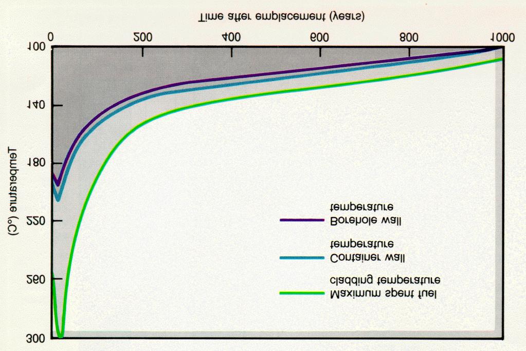
13 Thermohydrologic Modeling of Yucca Mountain One- and two- dimensional simulations of the unsaturated zone (UZ). Three-dimensional simulations of the saturated zone (SZ). Thermo-hydrologic response following emplacement of heat-generating waste packages with an assumed heat load of 83 kw/acre. Objectives 1) describe the different thermal regimes 2) assess the thermally driven alterations to the hydrologic conditions 3) quantify the time to return to ambient conditions, and 4) identify the most likely and significant scenarios that may lead to radionuclide releases. Heating of the repository occurs from approximately 0 to 1000 years, followed by cooling for tens of thousands of years. A large boiling zone develops above the repository because of buoyant convection, extending nearly 200 m above the repository between years. The boiling zone collapses entirely after several thousand years, but the region continues to cool for tens of thousands of years.
14
15 Volcanic Activity Caldera Formation The caldera complex, the source of Yucca Mountain's welded tuffs, is about 20 miles across and centered about 17 miles north of the mountain.


16 Volcanic History Volcano that formed Yucca Mountain is long extinct, but scientists are studying seven small and long inactive volcanoes in the Yucca Mountain area. They want to determine if one might erupt in the next 10,000 years and if an eruption might affect an underground nuclear repository. By studying layers of soil and rock to learn about past volcanic activities, scientists have been able to make predictions about the future. The probability of a future volcanic eruption directly intersecting a repository at Yucca Mountain is estimated to be about one in 70,000,000 per year, as confirmed by an independent panel of experts. This is in line with earlier estimates by Project scientists. source: OCRWM 16

17 Performance Assessment for Radioactive Waste Disposal Yucca Mountain, Nevada Simple drawings show an underground repository under different sets of conditions that might occur during its period of performance. 17

18 Y all come on in; make yourself at home..
Name Class Date. Study Guide for 7 th Grade Final Exam (Semester One)
") Name Class Date Study Guide for 7 th Grade Final Exam (Semester One) 1. What are the steps of the scientific method? Define the problem or question Form a hypothesis (MUST BE TESTABLE) o (identify variables)
Name Class Date Study Guide for 7 th Grade Final Exam (Semester One) 1. What are the steps of the scientific method? Define the problem or question Form a hypothesis (MUST BE TESTABLE) o (identify variables)
Uncertainty Underground: Yucca Mountain and the Nation s High-Level Nuclear Waste. Allison Macfarlane July 7, 2006 STS Program, MIT
 Uncertainty Underground: Yucca Mountain and the Nation s High-Level Nuclear Waste Allison Macfarlane July 7, 2006 STS Program, MIT Uncertainty Underground Purpose of book rectify lack of geologic input
Name Date Class. Directions: Use the diagram below to answer question Florida Progress Monitoring and Benchmark Assessments
 b e n c h m a r k t e s t : e a r t h a n d s p a c e s c i e n c e Multiple Choice 1. Geologists obtain indirect evidence about Earth s interior by A measuring pressure differences at Earth s surface.
TAKE HOME EXAM 8R - Geology
 Name Period Date TAKE HOME EXAM 8R - Geology PART 1 - Multiple Choice 1. A volcanic cone made up of alternating layers of lava and rock particles is a cone. a. cinder b. lava c. shield d. composite 2.
1. In the block diagram shown here, which is the oldest rock unit?
 Pre/Post GCI Name (print) 1. In the block diagram shown here, which is the oldest rock unit? 2. Referring to the same diagram as the previous question, which of the labeled rock units is the youngest?
MODELING COUPLED PROCESSES OF MULTIPHASE FLOW AND HEAT TRANSFER IN UNSATURATED FRACTURED ROCK
 MODELING COUPLED PROCESSES OF MULTIPHASE FLOW AND HEAT TRANSFER IN UNSATURATED FRACTURED ROCK YU-SHU WU 1, S. MUKHOPADHYAY 1, K. ZHANG 1, AND G. S. BODVARSSON 1 1 Earth Sciences Division, Lawrence Berkeley
Characterization of flow and transport processes within the unsaturated zone of Yucca Mountain, Nevada, under current and future climates
 Journal of Contaminant Hydrology 54 (2002) 215 247 www.elsevier.com/locate/jconhyd Characterization of flow and transport processes within the unsaturated zone of Yucca Mountain, Nevada, under current
From Punchbowl to Panum: Long Valley Volcanism and the Mono-Inyo Crater Chain
 From Punchbowl to Panum: Leslie Schaffer E105 2002 Final Paper Long Valley Volcanism and the Mono-Inyo Crater Chain Figure 1. After a sequence of earthquakes during the late 1970 s to the early 1980 s
Tuesday, September 05, 2017 Planet Earth
 Tuesday, September 05, 2017 Planet Earth Objective: Describe the solar system and Earth s location in it. Identify Earth s shape. Discuss Earth s structure. List Earth s landforms Do Now: What is a compass
GO ON. Directions: Use the diagram below to answer question 1.
 d i a g n o s t i c t e s t : e a r t h a n d s p a c e s c i e n c e question 1. 1. What is the correct order (starting from the surface) of Earth s layers? A crust, outer core, inner core, mantle B mantle,
Deep Borehole Disposal Performance Assessment and Criteria for Site Selection
 Deep Borehole Disposal Performance Assessment and Criteria for Site Selection Sandia is a multiprogram laboratory operated by Sandia Corporation, a Lockheed Martin Company, for the United States Department
Page One. GEOL 1030 Pre test S15. Please enter your rst and last name.
 GEOL 1030 Pre test S15 Page One Please enter your rst and last name. First Name: Last Name: 1. The most common elements in the Earth's crust, in order of decreasing abundance, are: a. feldspar, quartz,
NUCLEAR WASTE DISPOSAL (44)
") GG 454 May 1, 2002 1 NUCLEAR WASTE DISPOSAL (44) I Main topics A Types of nuclear waste B Disposal options C Experience of different countries in nuclear waste disposal D U.S. approach to nuclear waste
GG 454 May 1, 2002 1 NUCLEAR WASTE DISPOSAL (44) I Main topics A Types of nuclear waste B Disposal options C Experience of different countries in nuclear waste disposal D U.S. approach to nuclear waste
Name: Answer Key Date: Period:
 Name: Answer Key Date: Period: Earth Science Final Exam Study Guide Ch 1: Mapping 1. On the global grid, the equator is at 0 degrees. Is the equator a line of longitude or latitude? Latitude 2. What type
GEOLOGY CURRICULUM. Unit 1: Introduction to Geology
 Chariho Regional School District - Science Curriculum September, 2016 GEOLOGY CURRICULUM Unit 1: Introduction to Geology OVERVIEW Summary In this unit students will be introduced to the field of geology.
STUDY GUIDE FOR MID-TERM EXAM KEY. Color, luster, cleavage, fracture, hardness, taste, smell, fluorescence, radioactivity, magnetism
 STUDY GUIDE FOR MID-TERM EXAM KEY 1. In which type of rock are fossils most likely to be found? Sedimentary Rocks 2. Which mineral is easily identified by smell? Sulfur 3. Which natural resource makes
Earth Science Institute II June 23, 2010 Day 3 Correlation of EarthComm Curriculum and HSCE s
 Earth Science Institute II June 23, 2010 Day 3 Correlation of EarthComm Curriculum and s EDG1 = Earth s Dynamic Geospheres: Chapter 1, Volcanoes EDG2 = Earth s Dynamic Geospheres: Chapter 2, Plate Tectonics
Plate Tectonics. I. The Discovery of Plate Tectonics II. A Mosaic of Plates III. Types of Plate Boundaries IV. How Plates Move
 Plate Tectonics I. The Discovery of Plate Tectonics II. A Mosaic of Plates III. Types of Plate Boundaries IV. How Plates Move I. The Discovery of Plate Tectonics A. Continental Drift (Alfred Wegener) Proposed
The Official CA State Science Education Standards for Earth Science K 8
 The Official CA State Science Education Standards for Earth Science K 8 Kindergarten The Earth is composed of land, air and water. As a basis for understanding this concept, students know: a. characteristics
Study Guide: Unit 3. Density and Pressure: You should be able to answer the types of questions given in the end of module questions.
 IDS 102 Study Guide: Unit 3 The purpose of this study guide is to help you prepare for the third exam by focusing your studying and providing example essay questions. In the Focus On section you will find
Before Plate Tectonics: Theory of Continental Drift
 Before Plate Tectonics: Theory of Continental Drift Predecessor to modern plate tectonics Shape and fit of the continents was the initial evidence Snider-Pelligrini (1858) Taylor (1908) Wegner (1915) Fig.
MODELING WATER SEEPAGE INTO HEATED WASTE EMPLACEMENT DRIFTS AT YUCCA MOUNTAIN
 PROCEEDINGS, TOUGH Symposium 2003 Lawrence Berkeley National Laboratory, Berkeley, California, May 12 14, 2003 MODELING WATER SEEPAGE INTO HEATED WASTE EMPLACEMENT DRIFTS AT YUCCA MOUNTAIN Jens Birkholzer,
Earth s Interior HW Packet HW #1 Plate Tectonics (pages )
") Name Earth s Interior HW Packet HW #1 Plate Tectonics (pages 676 683) 1. Is the following sentence true or false? According to the theory of plate tectonics, Earth s plates move about quickly on top of
Name Earth s Interior HW Packet HW #1 Plate Tectonics (pages 676 683) 1. Is the following sentence true or false? According to the theory of plate tectonics, Earth s plates move about quickly on top of
Prentice Hall: Science Explorer, 16 Book Series 2005 Correlated to: Alabama Science Standards for Earth and Space Science Core (Grade 6)
") Alabama Science Standards for Earth and Space Science Core (Grade 6) 1. Identify global patterns of atmospheric movement, including El Niño, the Gulf Stream, the jet stream, the Coriolis effect, and global
Alabama Science Standards for Earth and Space Science Core (Grade 6) 1. Identify global patterns of atmospheric movement, including El Niño, the Gulf Stream, the jet stream, the Coriolis effect, and global
The outermost container into which vitrified high level waste or spent fuel rods are to be placed. Made of stainless steel or inert alloy.
 Glossary of Nuclear Waste Terms Atom The basic component of all matter; it is the smallest part of an element having all the chemical properties of that element. Atoms are made up of protons and neutrons
Ch 17 Plate Tectonics Big Idea: Most geologic activity occurs at the boundaries between plates.
 Ch 17 Plate Tectonics Big Idea: Most geologic activity occurs at the boundaries between plates. 17.1 Drifting Continents 17.2 Seafloor Spreading 17.3 Plate Boundaries 17.4 Causes of Plate Motions Learning
Underground nuclear waste storage
 Underground nuclear waste storage Groundwater flow and radionuclide transport Jan-Olof Selroos Cargese Summer School, July 5, 2018 Contents: Concept for geological disposal of nuclear waste A few words
Topics: The Layers of the Earth and its Formation Sources of Heat Volcanos and Earthquakes Rock Cycle Rock Types Carbon Tax
 Topics: The Layers of the Earth and its Formation Sources of Heat Volcanos and Earthquakes Rock Cycle Rock Types Carbon Tax Essay Question on Carbon Tax 1. Drilling 2. Volcanic Activity 3. Laboratory experiments
Core. Crust. Mesosphere. Asthenosphere. Mantle. Inner core. Lithosphere. Outer core
 Potter Name: Date: Hour: Score: /21 Learning Check 4.1 LT 4.1 Earth s Interior: I can draw and interpret models of the interior of the earth. Draw the following models (put the words in the right order)
Plate Tectonics. Continental Drift Sea Floor Spreading Plate Boundaries
 Plate Tectonics Continental Drift Sea Floor Spreading Plate Boundaries Continental Drift 1915, Alfred Wegener - Pangea hypothesis: suggested Earth s continents were part of a large super-continent 200
Chapter Two. Figure 02_02. Geography of the Ocean Basins. The Sea Floor
 Chapter Two The Sea Floor Geography of the Ocean Basins Figure 02_02 The world ocean is the predominant feature on the Earth in total area. In the Northern Hemisphere, 61% of the total area is ocean. In
TO GO TO ANY OF THE PAGES LISTED BELOW, CLICK ON ITS TITLE
 TO GO TO ANY OF THE PAGES LISTED BELOW, CLICK ON ITS TITLE CHAPTER 6 Plate Tectonics 1 6-1 What is continental drift? 2 6-2 Why is the seafloor spreading? 3 6-3 What evidence supports seafloor spreading?
Plate Tectonics. Chapter 17. Great Idea: The entire Earth is still changing, due to the slow convection of soft, hot rocks deep within the planet.
 Plate Tectonics Chapter 17 Great Idea: The entire Earth is still changing, due to the slow convection of soft, hot rocks deep within the planet. 1 Chapter Outline The Dynamic Earth Plate Tectonics: A Unifying
Earth Science. Explain how Earth's biogeochemical cycles create a balance of materials. Examine the importance of biogeochemical cycles.
 Unit 1: DYNAMIC STRUCTURE OF EARTH Introduction to Understand that earth science is based upon the four sciences of astronomy, geology, meteorology, and oceanography. Identify topics studied within the
RAYMOND SIEVER Harvard University
 E A R T H FOURTH EDITION FRANK PRESS National Academy of Sciences RAYMOND SIEVER Harvard University W. H. Freeman and Company New York Preface xiii Acknowledgments xviii PART I PROLOGUE CHAPTER 1 HISTORY
Year 9 Geography end of Year Examination
 Year 9 Geography end of Year Examination Answer all of the questions on the file paper provided. 1. Label the diagram below. Write down the number of the box where the label should go and the letter of
b. atomic mass H What is the density of an object with a volume of 15cm 3 and a mass of 45g?
 Name Period Date Earth Science Midterm Review 2015-2016 Quarter 1 Review Assign #1 Basic Chemistry An atom is a basic chemical building block of matter. An atom consists of protons, neutrons, and electrons.
Earth s Structure and Surface
 Earth s Structure and Surface Structure of the Earth The earth is thought have originated about 4.5 billion years ago from a cloud or clouds of dust. The dust was the remains of a huge cosmic explosion
General Oceanography Geology 105 Expedition 8 Plate Boundaries Beneath the Sea Complete by Thursday at 11:00 PM
 General Oceanography Geology 105 Expedition 8 Plate Boundaries Beneath the Sea Complete by Thursday at 11:00 PM Name Expedition Objectives Learn about the types of plate boundaries and their key characteristics
Directed Reading. Section: The Theory of Plate Tectonics. to the development of plate tectonics, developed? HOW CONTINENTS MOVE
 Skills Worksheet Directed Reading Section: The Theory of Plate Tectonics 1. The theory that explains why and how continents move is called. 2. By what time period was evidence supporting continental drift,
Inside Planet Earth: Surface to Center
 Inside Planet Earth: Surface to Center Section 1: Introduction 1. What percentage of the Earth cannot be accessed by humans? 99% 2. True or False: It would be easier to invent something to travel to the
Lawrence Berkeley National Laboratory Lawrence Berkeley National Laboratory
 Lawrence Berkeley National Laboratory Lawrence Berkeley National Laboratory Title TOUGHREACT: a new code of the TOUGH Family for Non-Isothermal multiphase reactive geochemical transport in variably saturated
Conceptual Understandings for K-2 Teachers
 AFK12SE/NGSS Strand Disciplinary Core Ideas ESS1: Earth s Place in the Universe What is the universe, and what is Earth s place in it? ESS1. A: The Universe and Its Stars What is the universe, and what
Magnetism. Geology. Size and Shape Relationships
 Magnetism Some types of rocks have a Magnetic North and a Magnetic South. This magnetic orientation is established when the rock is formed. If the landmasses or continents of the Earth had remained fixed
New A-Level Physical Geography
 Half Term 1 3.1 Physical Geography: 3.1.5 Hazards: Plate Tectonics This optional section of our specification focuses on the lithosphere and the atmosphere, which intermittently but regularly present natural
PLATE TECTONICS REVIEW GAME!!!!
 PLATE TECTONICS REVIEW GAME!!!! Name the four layers of the earth - crust - mantle - outer core - inner core Which part of Earth s structure contains tectonic plates? LITHOSPHERE Name one reason why the
Required Materials Plummer, C., Physical geology. Columbus, OH: McGraw Hill Higher Education
 Butler Community College Science, Technology, Engineering, and Math Division Robert Carlson Revised Fall 2017 Implemented Spring 2018 Textbook Update Spring 2018 COURSE OUTLINE Physical Geology Course
Chapter 1: Earth as a System
 Chapter 1: Earth as a System Science is: Any system of knowledge which tries to observe, identify, understand and describe the nature of the Universe in whole or part. Science explains and predicts the
Miami-Dade College. The student will demonstrate a basic knowledge of the origin and evolution of the Earth and its planetary environment.
 Miami-Dade College Common Course Number: GLY 3884 Course Title: Environmental Geology Catalog Course Description: This course focuses on the study of the application of geology to the interactions between
STUDY GUIDE FOR CONTENT MASTERY. Surface Water Movement
 Surface Water SECTION 9.1 Surface Water Movement In your textbook, read about surface water and the way in which it moves sediment. Complete each statement. 1. An excessive amount of water flowing downslope
Ch 9.1 Notes. Objective: Be able to explain the theory of plate tectonics and be able to explain evidence that supports it.
 Ch 9.1 Notes Objective: Be able to explain the theory of plate tectonics and be able to explain evidence that supports it. Pangaea Alfred Wegener proposed that land on Earth formed a single, huge landmass.
Marine Science and Oceanography
 Marine Science and Oceanography Marine geology- study of the ocean floor Physical oceanography- study of waves, currents, and tides Marine biology study of nature and distribution of marine organisms Chemical
Section 1: Earth s Interior and Plate Tectonics Section 2: Earthquakes and Volcanoes Section 3: Minerals and Rocks Section 4: Weathering and Erosion
 Section 1: Earth s Interior and Plate Tectonics Section 2: Earthquakes and Volcanoes Section 3: Minerals and Rocks Section 4: Weathering and Erosion Key Terms Crust Mantle Core Lithosphere Plate Tectonics
Earth s Magnetic Field Differential Rotation between the inner core and the outer core.
 Geology 15 Lecture 7 Schedule: Hazard Update: Review Lecture 6 Activity 2 cont: Plate Boundaries and Their Motions Cover Material/Objectives Plate Tectonics (continued) Earth s Structure Evidence for Continental
Quiz. Go to Hammer Science > Earth Science Click on Earth Layers Quiz Take the Quiz Read something silently when you are done
 Bell Ringer 1. List the members in your poster group 2. Assign percentages for how much you think they participated in the poster. 3. Go to https://goo.gl/yd14px and take the survey. Use your phone or
Resources. Classroom Conduct. Geology 1002 (Section 1) Honors Physical Geology Howe-Russell E131 TTh 9:00-10:30
 Honors Physical Geology Howe-Russell E131 TTh 9:00-10:30") Geology 1002 (Section 1) Honors Physical Geology Howe-Russell E131 TTh 9:00-10:30 Instructor: Jeffrey A. Nunn Office:Room E235 Howe-Russell Telephone:578-3353 e-mail: gljeff@lsu.edu Office hours: 4:00
Geology 1002 (Section 1) Honors Physical Geology Howe-Russell E131 TTh 9:00-10:30 Instructor: Jeffrey A. Nunn Office:Room E235 Howe-Russell Telephone:578-3353 e-mail: gljeff@lsu.edu Office hours: 4:00
Plate Tectonics Practice Test
 Plate Tectonics Practice Test 1. What is the main idea Alfred Wegner proposed in the Theory of Continental Drift that he published in 1915? a. The continents float on a liquid layer that allows them to
L wave Lahar Lava Magma
 Very large collapsed volcanic crater, often containing a lake eg. Lake Taupo The process which provides the force to move the tectonic plates Innermost part of the Earth, made of a liquid outer core and
Processes That Shape the Earth Weather, Part I
 Grade 6 Science, Quarter 4, Unit 4.1 Processes That Shape the Earth Weather, Part I Overview Number of instructional days: 25 (1 day = 45 minutes) Content to be learned Explain how condensation of water
Potential Igneous Processes Relevant to the Yucca Mountain Repository: Intrusive-Release Scenario
 Potential Igneous Processes Relevant to the Yucca Mountain Repository: Intrusive-Release Scenario M. Apted, M. Kozak Monitor Scientific LLC 3900 South Wadsworth Blvd., Denver, Colorado 80235 USA J. Kessler
6. The lithosphere is
 Name: APES: Geology and Nonrenewable Mineral Resources Earth Composition and Structure Webquest Date: I. Earth Structure http://scign.jpl.nasa.gov/learn/plate1.htm Click on the button press here to see
FORCES ON EARTH. An investigation into how Newton s Laws of Motion are applied to the tectonic activity on Earth.
 FORCES ON EARTH An investigation into how Newton s Laws of Motion are applied to the tectonic activity on Earth. GEOLOGY Geologists scientists who study the forces that make and shape the Earth Geologists
General Oceanography Geology 105 Expedition 8 Plate Boundaries Beneath the Sea
 General Oceanography Geology 105 Expedition 8 Plate Boundaries Beneath the Sea Name Not attempting to answer questions on expeditions will result in point deductions on course workbook (two or more blank
Ch. 9 Review. Pgs #1-31 Write Questions and Answers
 Ch. 9 Review Pgs. 356-357 #1-31 Write Questions and Answers 356-357 #1-5 Answers 1. The layer of the upper mantle that can flow is the: A - Asthenosphere 2. Most scientists rejected Wegener s theory of
LANDFORMS CREATED AND CHANGED?
 HOW ARE LANDFORMS CREATED AND CHANGED? Landforms are created by different natural forces. Some are within Earth, and some are on the surface of Earth. Landforms can also be changed by humans. These changes
School District of Clay County Science Curriculum Map Grade 7. Optional Title Text Lessons Standards Frame
 First Semester School District of Clay County Science Curriculum Map Grade 7 *The total of 10 Science Fair should be split between 1 st and 2 nd 9 weeks to best fit individual school/teacher needs Time
High School Earth Science. High Science Strand 1: Earth s Place in the Universe
 High Science Strand 1: Earth s Place in the Universe Code Proposed Standards Existing GLES HS-ESS1-1. Develop a model based on evidence to illustrate the life span of the Sun and the role of nuclear fusion
Along the center of the mid-ocean ridge is a rift valley that forms when the plates separate.
 Newly formed rock from rising magma rises above sea floor and forms mountain ranges known as midocean ridges. Along the center of the mid-ocean ridge is a rift valley that forms when the plates separate.
OUTCOMES BASED LEARNING MATRIX. Course: Physical Geology Department: _Physical Science. Study the text and lecture material
 OUTCOMES BASED LEARNING MATRIX Course: Physical Geology Department: _Physical Science Physical Geology This course is intended to acquaint students with the physical structure of the Earth, the nature
Dynamic Earth A B1. Which type of plate boundary is located at the Jordan Fault? (1) divergent (3) convergent (2) subduction (4) transform
 divergent (3) convergent (2) subduction (4) transform") Dynamic Earth A B1 1. The edges of most lithospheric plates are characterized by (1) reversed magnetic orientation (2) unusually rapid radioactive decay (3) frequent volcanic activity (4) low P-wave and
Dynamic Earth A B1 1. The edges of most lithospheric plates are characterized by (1) reversed magnetic orientation (2) unusually rapid radioactive decay (3) frequent volcanic activity (4) low P-wave and
Section 1: How Did Life Begin? Chapter 19: History of Life on Earth. Section 2: The Age of Earth
 Chapter 19: History of Life on Earth Section 1: How Did Life Begin? I. The Basic Chemicals of Life A. 1920s B. Earth s early oceans contained large amounts of organic molecules C. Molecules formed spontaneously
Homework III. Volcanological Exercises
 Page 1 of 5 EENS 3050 Tulane University Natural Disasters Prof. Stephen A. Nelson Homework III. Volcanological Exercises This page last updated on 16-Feb-2018 1. In your work as an insurance company executive
Determining Earth's History Rocks and Ice Cores
 Earths History Reu2.notebook November 14, 2013 Determining Earth's History Rocks and Ice Cores One goal of geology is to develop a timeline of Earth's past, including both geological and biological events.
The Sea Floor. Chapter 2
 The Sea Floor Chapter 2 Geography of the Ocean Basins World ocean is the predominant feature on the Earth in total area Northern Hemisphere = 61% of the total area is ocean. Southern Hemisphere = about
Visualizing Earth Science. Chapter Overview. Volcanoes and Eruption Types. By Z. Merali and B. F. Skinner. Chapter 9 Volcanism and Other
 Visualizing Earth Science By Z. Merali and B. F. Skinner Chapter 9 Volcanism and Other Igneous Processes Volcanoes types and effects of eruption Chapter Overview Melting and cooling of rocks Geological
Rock Cycle. Draw the Rock cycle on your remediation page OR use a sheet of notebook paper and staple
 Earth Science Test 8.ESS2.3) Describe the relationship between the processes and forces that create igneous, sedimentary, and metamorphic rocks. I can develop and use models to explain how plate movements
Identify and explain monthly patterns in the phases of the Moon.
 (NGSS in Parentheses) Grade Big Idea Essential Questions Concepts Competencies Vocabulary 2002 Standards The phases of the Moon are caused by the orbit of the moon around the Earth. (ESS1.A) The phases
Geological Repositories. Michael Voegele
 Geological Repositories Michael Voegele Need for Repositories Commercial nuclear development followed Eisenhower's Atoms for Peace speech. By the mid-1950s, the United States had made a decision to take
Plate Tectonic Vocabulary Chapter 10 Pages
 Name: Period: Plate Tectonic Vocabulary Chapter 10 Pages 239-260 Vocabulary Word What is this? What are some examples? What does it look like? (draw a picture or diagram) Continental drift Mid-ocean ridge
Earth s Many Landforms. Earth s Many Landforms. Earth s Many Landforms. Crustal Deformation. Crustal Deformation 10/22/2014
 Hewitt/Lyons/Suchocki/Yeh Conceptual Integrated Science Chapter 24 EARTH S SURFACE LAND AND WATER Earth s Many Landforms Earth consists of seven continents: Africa, Antarctica, Asia, Australia, Europe,
Tectonics. Planets, Moons & Rings 9/11/13 movements of the planet s crust
 Tectonics Planets, Moons & Rings 9/11/13 movements of the planet s crust Planetary History Planets formed HOT Denser materials fall to center Planet cools by conduction, convection, radiation to space
The Main Point. Other Properties Earth has one large Moon. Earth has a strong Magnetic Field. Lecture #11: Earth: Geology and Interior
 Lecture #11: Earth: Geology and Interior Overview of Earth's basic properties. Earth's Interior and Surface: Composition and Structure. Surface Geologic Processes. Evolution of the Surface. Reading: Chapters
Passage (click here to show all)
") Passage (click here to show all) Use the information in the table and maps below to answer questions #-##. Weather Table and Maps The weather information shown below was reported on Sunday, the 15th of
Passage (click here to show all) Use the information in the table and maps below to answer questions #-##. Weather Table and Maps The weather information shown below was reported on Sunday, the 15th of
2. Explain why there are these two predominate elevations. (Hint: think about isostasy and the type of materials we used to demonstrate buoyancy).
.") IDS 102 Plate Tectonics Questions Part I: Observations- Four maps of world are positioned around the room. Answer the questions associated with each map and record your general observations about the maps.
IDS 102 Plate Tectonics Questions Part I: Observations- Four maps of world are positioned around the room. Answer the questions associated with each map and record your general observations about the maps.
Introduction to Landform Study Chapter 13
 Introduction to Landform Study Chapter 13 Geomorphology The study of the characteristics, origin, and development of landforms 58 million square miles of land 7 continents Wide latitudinal range and environmental
Tectonic Plates Lexile 840L
 6.10: Tectonic Plates Tectonic Plates Lexile 840L 1 On March 11, 2011, an earthquake measuring 8.9 on the Richter scale rocked the sea floor. It made a giant wave, which grew as tall as 30 feet (9.14 meters)
Chapter 2 Plate Tectonics and the Ocean Floor
 Chapter 2 Plate Tectonics and the Ocean Floor Matching. Match the term or person with the appropriate phrase. You may use each answer once, more than once or not at all. 1. hydrothermal vents A. convergent
Course Description. Course Objectives and Standards
 Earth and Space Science Curriculum Course Description Earth and Space Science 1 State # 3044 Grades offered: 10-12 Credits: A two credit course Prerequisite: none Counts as a Science Course for the General,
Chapter 5 Notes: Plate Tectonics
 Chapter 5 Notes: Plate Tectonics Earth s Interior Scientists learn about the interior of Earth in 2 ways o Direct Method Rock Samples Drilling Caves o Indirect Method Seismic Waves Speed of waves and paths
The Earth s Structure
 Planet Earth The Earth s Structure Crust the outermost and thinnest layer of Earth Mantle the layer of rock between the Earth s crust and its core - rocks are plastic soft and easily deformed The Earth
UNIT 1 - Major Land and Water Forms
 UNIT 1 - Major Land and Water Forms Chapter 1 - Landform Patterns and Processes Topography the natural and human features of the Earth s surface. ie. Surface features elevation - the height of a particular
A Living Planet. Chapter PHYSICAL GEOGRAPHY. What you will learn in this chapter. Summary of the chapter
 QUIT Main Ideas What you will learn in this chapter Summary Summary of the chapter Test your geographic knowledge by playing the. Main Ideas Section 1: The Earth Inside and Out The earth is the only habitable
Chapter 8 Earth Systems
 Chapter 8 Earth Systems Friedland and Relyea Environmental Science for AP, second edition 2015 W.H. Freeman and Company/BFW AP is a trademark registered and/or owned by the College Board, which was not
When volcanoes erupt, magma is released. Where does this
 38 Beneath the Earth s Surface R E A D I N G When volcanoes erupt, magma is released. Where does this magma come from? To answer this question, it helps to know more about the earth. Imagine taking a glass
1. What is Wegener s theory of continental drift? 2. What were the 4 evidences supporting his theory? 3. Why wasn t Wegener s theory excepted?
 Notebook 7a and 7b Objective (left-side): Students will be able to explain the theory of plate tectonics and be able to make predictions about plate interactions. Mapping Reflection 1. What is Wegener
correlated to the California Science Content Standards Grade 6
 correlated to the California Science Content s Grade 6 Publisher: McDougal Littell Program Title: McDougal Littell California Middle School Science Series Print Components Pupil Edition, Teacher s Edition,
Do Now: Vocabulary: Objectives. Vocabulary: 1/5/2016. Wegener? (Can they move?) the idea that continents have moved over time?
 the idea that continents have moved over time?") Do Now: 1. Who was Alfred Wegener? 2. What was Pangaea? 3. Are continents fixed? (Can they move?) 4. What evidence supports the idea that continents have moved over time? Objectives What evidence suggests
Do Now: 1. Who was Alfred Wegener? 2. What was Pangaea? 3. Are continents fixed? (Can they move?) 4. What evidence supports the idea that continents have moved over time? Objectives What evidence suggests
ABSTRACT INTRODUCTION
 Development and Calibration of Dual-Permeability Models in Complex Hydrogeologic Settings: An Example from the T-Tunnel Complex, Rainier Mesa, Nevada National Security Site Donald M. Reeves, Rishi Parashar,
Year 8 Level: 5-8 GEOGRAPHY Time: 1:30min
 Year 8 Level: 5-8 GEOGRAPHY Time: 1:30min Name: Class: Answer all questions in the space provided. 1. Label the diagram below using the following words; (4) mantle, crust, outer core, inner core 2. Write
Extra Credit Assignment (Chapters 4, 5, 6, and 10)
") GEOLOGY 306 Laboratory Instructor: TERRY J. BOROUGHS NAME: Extra Credit Assignment (Chapters 4, 5, 6, and 10) For this assignment you will require: a calculator and metric ruler. Chapter 4 Objectives:
GEOLOGY 306 Laboratory Instructor: TERRY J. BOROUGHS NAME: Extra Credit Assignment (Chapters 4, 5, 6, and 10) For this assignment you will require: a calculator and metric ruler. Chapter 4 Objectives: