CONTENTS TABLES. Table 5-1 Lithological Sequence of the Formations present in the Huntstown Quarry area, partly based on Jones et al
|
|
|
- Claud Harrell
- 5 years ago
- Views:
Transcription
1 CONTENTS INTRODUCTION... 2 BASELINE STUDY... 2 Outline... 2 Baseline Study Methodology... 2 Regional Geology... 2 Local Geology... 3 Mineralogy and Engineering Characteristics... 6 Karstification... 8 ASSESSMENT OF IMPACTS... 8 Direct impacts... 8 Indirect Impacts... 8 Soils... 8 Geology... 9 REFERENCES... 9 TABLES Table 5-1 Lithological Sequence of the Formations present in the Huntstown Quarry area, partly based on Jones et al FIGURES Figure 5.1 Soils Map... Figure 5.2 Subsoils Map... Figure 5.3 Regional Geology... Figure 5.4 Detailed Geology Map... Figure 5.5 Geological Cross-Section... PLATES Plate 5-1. Typical limestones exposed in the western face of the North Quarry. Note steep dip to northwest and well-bedded nature of the limestones. Plate 5-2. North-western area of North Quarry immediately northeast of borehole GW04. Note shales dominating sequence in upper part of quarry face. Plate 5-3. Huntstown Central Quarry. Exposure of the contact between the Waulsortian limestones of the Feltrim Limestone Formation to right and Tober Colleen Formation to left. Contact marked by arrow. Plate 5-4. Typical limestone sequence exposed in south-western part of the South Quarry APPENDICES Appendix 5-A Letter from the Geological Survey of Ireland (GSI) in relation to Geological Heritage Issues
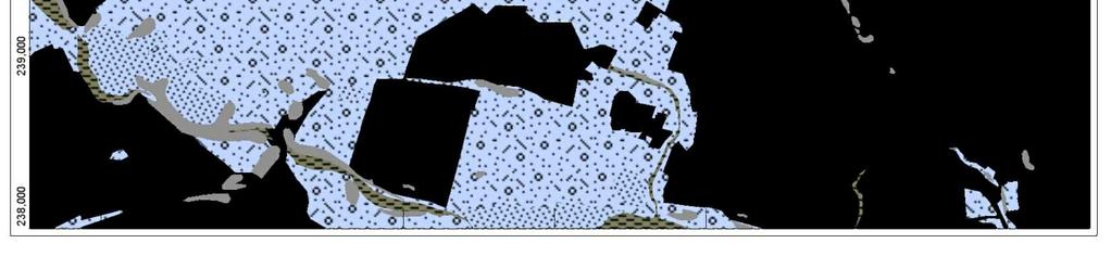
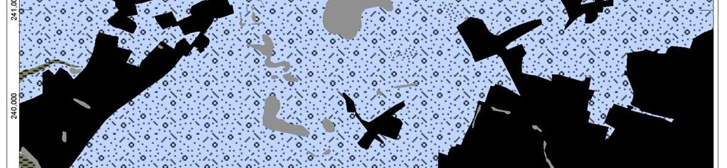
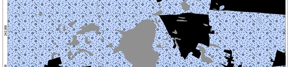
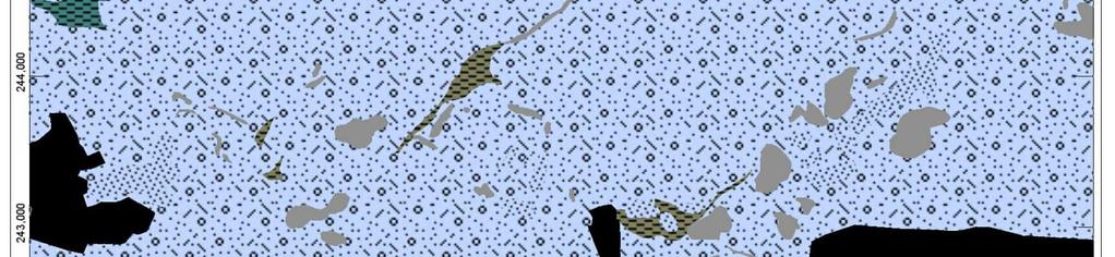
2 INTRODUCTION 5.1 This Environmental Impact Statement (EIS) evaluates the regional and local geological conditions, and assesses the impact that quarrying will have on the geology of the area and any other geological aspects of the further development of the quarry. It is based on detailed examination of the existing quarry and its surroundings and was prepared by EurGeol Dr. John Kelly PGeo, MIMMM, MIQ in accordance with the guidelines on Geology in Environmental Impact Statements issued by the Institute of Geologists of Ireland. BASELINE STUDY OUTLINE 5.2 Information on the solid and drift geology of the Huntstown area and its surrounds was collated and evaluated. Subsequent to this data compilation and review site visits were undertaken to review the solid and drift geology in the existing quarries and adjacent areas. 5.3 A drilling program was carried out in July 2010 to install six groundwater monitoring wells. Rock chip samples from this drilling were collected and have been examined to assist in assessing the geology in the Huntstown area. Borehole locations are shown on Figure 5.4 and borehole logs are presented in Section 6 of this EIS. BASELINE STUDY METHODOLOGY 5.4 The following activities were undertaken to allow a geological assessment to be completed: An examination of available geological information Examination of GSI 1:100,000 geology map sheets 13 and 16 Review of available geological information and literature Review of groundwater monitoring well drilling results Site inspection REGIONAL GEOLOGY Soils 5.5 Teagasc soil mapping shows the Huntstown site to be underlain by renzinas and lithosols and grey-brown podzolics and brown earths. There is a significant amount of made ground on the site which is not shown in the Teagasc mapping. (Figure 5.1). Due to the ongoing extractive operations and installation of plant and infrastructure, little areas of original soil remain. 5-2
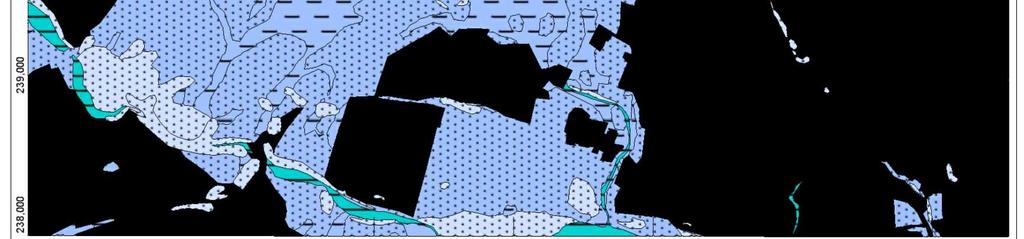
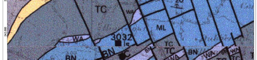
3 Quaternary Geology 5.6 Teagasc sub-soil parent material mapping shows the Huntstown site to be underlain by bedrock at, or close to, surface and glacial tills derived from Carboniferous limestones (Figure 5.2). Bedrock Geology 5.7 The GSI 1:100,000 geology map sheets 13 and 16 shows a complex geology (Figure 5.2). The site is underlain by the Malahide Formation in the southern part of the site. This is overlain to the northwest by Waulsortian Limestones of the Feltrim Limestone Formation which is, in turn, overlain to the northwest by the Tober Colleen Formation. The Tober Colleen Formation is in faulted contact with the Malahide Formation to the northwest, the Malahide Formation in this area reverse faulted to the south over the Tober Colleen. LOCAL GEOLOGY Introduction 5.8 There are currently three main areas at Huntstown where extraction is taking place, or has taken place in the past (Figure 5.4). These are referred to in turn as the North, Central and South Quarries. The extensive exposure in these working areas, in conjunction with information from the ground water well drilling, allows a reasonable assessment of the distribution of different lithological formations and the structure of the site to be made. 5.9 The geological sequence at Huntstown was investigated in detail by Jones et al. (1988) although at that time development the current South Quarry had not commenced. The sequence in the Huntstown area determined by Jones et al. is presented in Table 5.1 below. 5-3
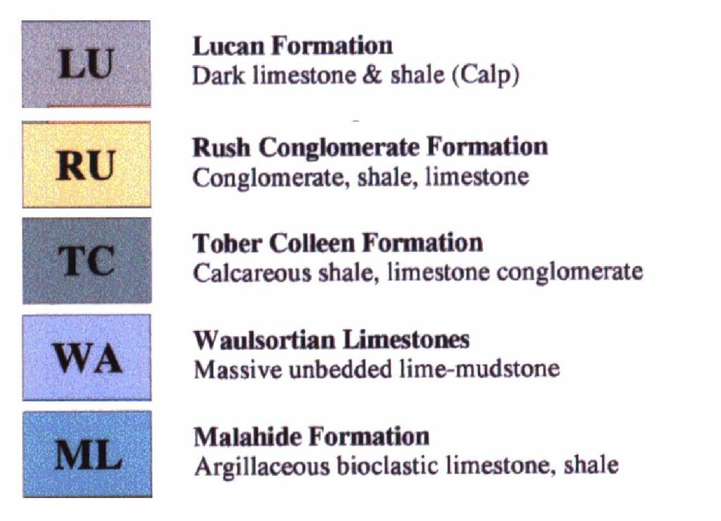
4 Table 0-1 Lithological Sequence of the Formations present in the Huntstown Quarry area, partly based on Jones et al FORMATION MEMBERS Estimated thickness Description LUCAN FORMATION 250m at Huntstown? 1000m+ Regionally Dark fine-grained limestone and thin shales TOBER COLLEEN FORMATION m? Shales and dark limestones FELTRIM LIMESTONE FORMATION (WAULSORTIAN) Barberstown Nodular Member Dunsoghley Massive Crinoidal Member Huntstown Laminated Member m 84m 47m 40m Pale-grey micritic sparry limestones Nodular limestones and shales Massive crinoidal limestones Laminated coarse limestones MALAHIDE LIMESTONE FORMATION St Margarets Banded Member 86m Interbedded shales and limestones Swords Argillaceous Bioclastic Member >860m Variable. Massive clean limestone units interbedded with banded limestone/shale units and argillaceous bioclastic limestones. Mudstone-dominated units have also been recorded Turvey Micrite Member 40m Micritic limestones and thin shales Lower Limestone Shale Unit >30m Limestone and shale 5-4
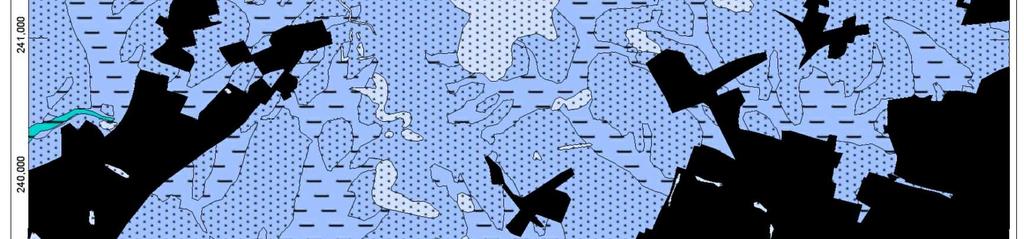
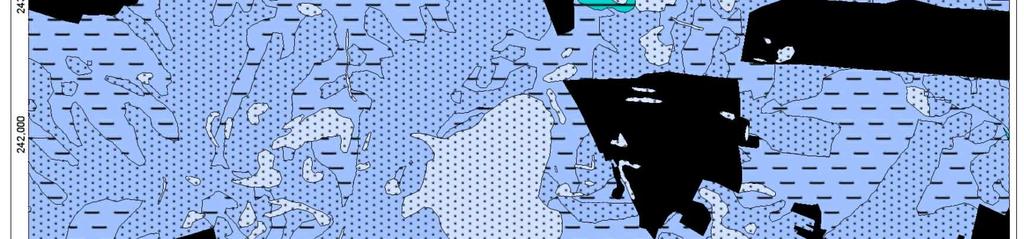
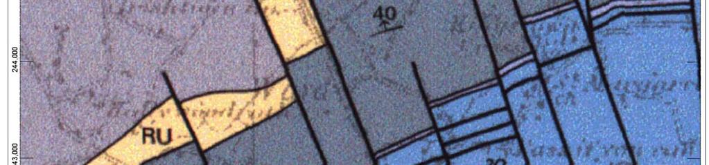
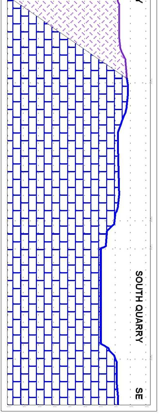
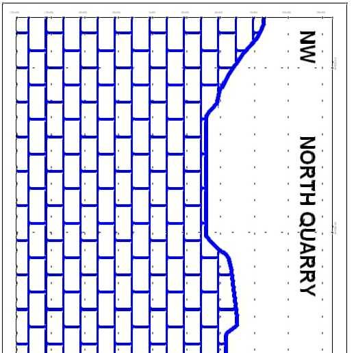
5 Soils and Superficial Deposits 5.10 Soils and superficial deposits have been entirely stripped from the footprint of the current and previous extraction areas and only minimal movement of soil and superficial deposit material is anticipated. Bedrock Geology 5.11 The South Quarry is developed within limestones of the Malahide Formation which dip steeply to the north in the eastern part of the quarry and to the northwest in the western part of the quarry. The limestones are dominated by well-bedded limestones with minor shales. Banded, interbedded limestones and shales are exposed in the northwestern corner of this extraction area The Central Quarry is not currently being worked and is used as a construction and demolition recycling facility. The quarry is developed in pale micritic Waulsortian limestones of the Feltrim Limestone Formation. The contact between the Waulsortian limestones and the overlying Tober Colleen Formation is exposed in the sides of the roadway accessing the Central Quarry from the north 5.13 The North Quarry is developed in a sequence of well-bedded limestones and academic research on the fossil fauna of the sequence exposed indicates that this quarry is also developed within sub-waulsortian limestones of the Malahide Formation. The sequence becomes shale dominated to the northwest as seen in borehole GW04 and in the upper part of the faces in the extreme northwest corner of the quarry From inspection of the existing extraction areas, it is apparent that future development at Huntstown quarry will continue to work the same limestone deposits as are presently being worked. Structure 5.15 The sequence at Huntstown dips steeply to the north or northwest (Figures 5.4 and 5.5), with recorded dip values varying from 23 in the east of the South Quarry. The sequence in the west of the South Quarry dips at 44 to the northwest. The sequence in the Central Quarry is recorded as dipping at 54 to the northwest. The sequence in the North Qu arry dips reasonably uniformly to the northwest or north-northwest, with dip values varying from 30 to As the limestones exposed in the North Quarry have been dated as being older than, and therefore stratigraphically below, the Waulsortian Limestones of the Central Quarry, there must be a significant reverse fault present between the central and southern quarries. A probable fault plane has been identified in the immediate southern part of the North Quarry where the main access road enters this area. This is interpreted as part of the trace of the 5-5
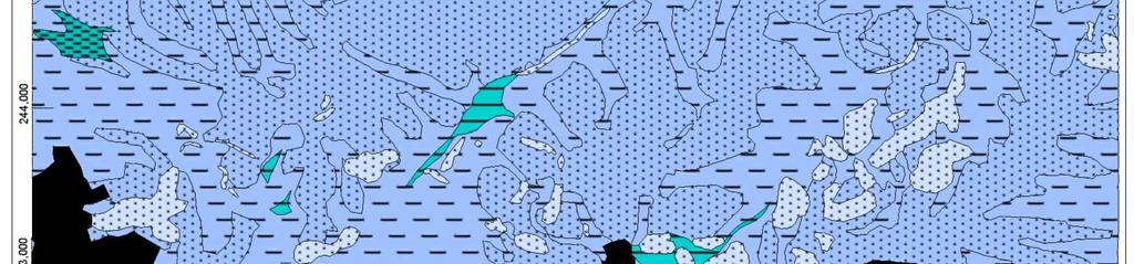
6 reverse fault and the trace of the reverse fault has therefore been located on the basis of this exposure The Tober Colleen Formation is interpreted as being approximately 200m thick in the Huntstown area and the steep dip suggests that the sub-crop area of the Tober Colleen Formation would be approximately 100m in width from the exposure of the basal contact of this unit in the Central Quarry access road. In light of this, it would be expected that the area between the top of the Tober Colleen and the reverse fault should be underlain by limestones of the Lucan Formation which lies above the Tober Colleen in the sequence. Rock exposures in the proposed western quarry were examined but determination of these rocks as being Lucan or Malahide Formation can only be undertaken by biostratigraphic analysis The rocks are well jointed. The dominant joint-set trends roughly N-S and are sub-vertical, typically dipping between 87 east an d 87 west. These joints are frequently associated with calcite or calcite dolomite veins. In some locations they may be solutionally enlarged and have brown clay fills which are rare in the northern and southern quarries, but are more common in the Central Quarry The rock is strong to very strong and weathering is rarely significant more than a few decimetres below the rock surface. Geological Heritage 5.20 Consultations have been made with the Geological Survey of Ireland in relation to the geological heritage aspects at Huntstown. The contact between the Waulsortian Limestones of the Feltrim Limestone Formation and the Tober Colleen Formation, exposed in the roadway into the Central Quarry, has been listed as part of Irish Geological Heritage Programme The IGH Programme staff have visited the relevant parts of Huntstown Quarry and their comments are presented in Appendix 5-A. Roadstone Wood Ltd. will ensure that the relevant geological section and rock exposure will be maintained. MINERALOGY AND ENGINEERING CHARACTERISTICS Introduction 5.22 Crushed rock, and the overlying sand & gravel currently extracted from Huntstown Quarry are used for a wide range of aggregate uses including:- Concrete products Readymix concrete Road sub-base, base and blacktop (tarmacadam) surfacing General aggregate, fill etc. 5-6
7 Aggregate Testing 5.23 A range of aggregate test results are undertaken by Roadstone Wood on aggregates produced at Huntstown. Aggregate testing was undertaken by accredited laboratories in Ireland and the UK Aggregate tests undertaken include: Fines Content Flakiness Index Micro-Deval Los Angeles Test Polished Stone Value Aggregate Abrasion Value Particle Density and Water Absorption Magnesium Sulphate Test Drying Shrinkage Chloride Content Acid Soluble Sulphate Total Sulphur 5.25 From the results of the regular aggregate testing programme, aggregates produced at Huntstown comply with the quality requirements outlined in: Aggregates for Bituminous Mixtures and Surface Treatments for Roads, Airfields and other Trafficked areas to :EN (S.R.17) Aggregates for Concrete to EN (S.R. 16) 5-7
8 KARSTIFICATION Introduction 5.26 The presence, nature and extent of any karstification at Huntstown Quarry has been assessed. Inspection of the existing quarry revealed a number of minor solutionally enlarged and clay-infilled joints, particularly in the Central Quarry. One particularly wide joint is exposed in the eastern part of the South Quarry where the joint has been enlarged to approximately 0.5m to 2.0m in width. This feature appears to pinch rapidly to the south and would be expected to pinch with depth. The quarry manager reports that these features do not significantly interfere with quarrying operations A thin zone of epikarst is developed immediately below the contact between bedrock and overburden. In the existing quarry faces, this epikarst zone extends for only 1.0m into the bedrock and is characterised by slight enlargement of joints by solution No significant karstification was observed in the ground water boreholes. ASSESSMENT OF IMPACTS DIRECT IMPACTS 5.29 The nature of the development will entail blasting and removal of bedrock. The quarry footprint will not be significantly extended so no large-scale removal and placement of soil and overburden is anticipated. Thus there will be a direct and irreversible impact on the existing in situ bedrock. INDIRECT IMPACTS 5.30 The development will not have an indirect impact on the geological aspects of the environment outside the footprint of the quarry area. Groundwater aspects of the quarry development are assessed in Section 6 of this EIS. SOILS 5.31 The quarry development will have a long-term land take of c.55.9 hectares. Any topsoil / subsoil and overburden material will be removed and then, in conjunction with previously removed materials will be: Used to create landscaped screening berms around the perimeter of the site. Topsoil to be used for the restoration of the site when infilled back to original ground level as detailed in the site restoration plan in Figure
9 5.32 To limit the effects of erosion on any soil materials the following measures are adopted. Stripping, removal and moving of soils will not take place during periods of prolonged dry weather. Where ever these materials are placed in either permanent or temporary locations, an angle of repose of no greater than 1: 1.5 will be used. This is considered the maximum acceptable slope to limit excessive erosion of the material. Screening berms will be planted / vegetated. Re-handling of soils will be minimised as much as possible in order to preserve the integrity of the topsoil material. This is also an economically prudent practice. GEOLOGY 5.33 Quarrying of aggregate material, by definition, requires the excavation and removal of rock material, thereby producing a permanent impact on the local bedrock environment within the quarry footprint The quarry restoration scheme will ultimately allow the site to be returned to a condition whereby there will be negligible residual impact on the surrounding environment due to the removal of rock material within the quarry The quarry restoration scheme will includes provision for retaining exposures of the contact between the Waulsortian and Tober Colleen Formation, for geological heritage and education purposes as recommended by the Geological Survey of Ireland. REFERENCES Jones, G.Ll., Somerville, I.D. and Strogen, P The Lower Carboniferous (Dinantian) of the Swords Area: Sedimentation and Tectonics in the Dublin Basin, Ireland. Geological Journal 23, p McConnell, B.J., Philcox, M.E., Sleeman, A.G., Stanley, G., Flegg, A.M., Daly, E.P. & Warren, W.P Geology of Meath. Geological Survey of Ireland Bedrock Geology 1:100,000 Scale Map Series, Sheet 13. McConnell, B.J. and Philcox, M.E Geology of Kildare - Wicklow. Geological Survey of Ireland Bedrock Geology 1:100,000 Scale Map Series, Sheet
10 FIGURES Figure 5.1 Soils Map (Soil type distribution in the Huntstown and surrounding area. From Teagasc soil mapping) Figure 5.2 Subsoils Map (Drift geology of Huntstown and surrounding area. From Teagasc sub-soil parent material mapping) Figure 5.3 Regional Geology (Solid Geology of Huntstown and surrounding area. From GSI 1:100,000 Sheets 13 and 16) Figure 5.4 Detailed Geology Map Figure 5.5 Geological Cross-Section 5-10
11 PLATES 5-11


12 Plate 5-1. Typical limestones exposed in the western face of the North Quarry. Note steep dip to northwest and well-bedded nature of the limestones. Plate 5-2. Northwestern area of North Quarry immediately northeast of borehole GW04. Note shales dominating sequence in upper part of quarry face. 5-12


13 Plate 5-3. Huntstown Central Quarry. Exposure of the contact between the Waulsortian limestones of the Feltrim Limestone Formation to right and Tober Colleen Formation to left. Contact marked by arrow. Plate 5-4. Typical limestone sequence exposed in southwestern part of the South Quarry 5-13
14
15


16

17 Co en t ns of co For py in rig sp ht ect ow ion ne pu r r rp eq os ui es re o d nl fo y. ra ny he ru ot se.

18
19 APPENDICES 5-14
20 Appendix 5-A Letter from the Geological Survey of Ireland (GSI) in relation to Geological Heritage Issues 5-15
21 Shane McDermott From: Sarah Gatley Sent: 29 June :07 To: John Kelly; Shane McDermott; Tim Paul Cc: Sophie Preteseille; Parkes, Matthew Subject: RE: EIS Huntstown Quarry_GSI submission Re: Roadstone Wood Ltd Huntstown Quarry Dear John, Following on from the site visit on 13 th June 2011 to Huntstown Quarry, arranged with Roadstone Wood Ltd and SLR Consulting, the Irish Geological Heritage and Planning Programme of the Geological Survey of Ireland (GSI), would like to make the following comments, in conjunction with the original comments made by on 4 th may 2011 (see below): The relevant sections of Tober Colleen Formation overlying Waulsortain, are exposed along both sides of the access road between the plant offices (North Quarry) and the Central (formerly South) Quarry, which is now used as a re-cycling facility. A barrier or berm of waste concrete protects passing quarry vehicles from the eastern scarp of interest, and thereby obscures a complete view of the section. However, it also serves to protect the section on this side from inadvertent damage by quarry traffic. The GSI understands that the area of geological interest has been documented in re-mapping of the quarry area in the current EIS preparation, by SLR (June 2011). Whilst GSI would ideally like to see that Roadstone Wood Ltd makes provision in its restoration plan for the preservation of, and access to, a representative section of this significant part of Ireland s Carboniferous stratigraphy, it understands that there is a backfilling requirement in the plan at the end of quarry life but that no disturbance of the sections is envisaged in the mid-term future. The GSI appreciates the co-operation of Roadstone Wood Ltd and SLR Consulting in the recognition of the geological heritage importance of the sections, and understands that Roadstone is amenable to facilitating future access by accredited geologists, subject to prior notice and due consideration to safety aspects. Kind regards Sarah Dr Sarah Gatley Senior Geologist, Head Geological Heritage & Planning Programme Geological Survey of Ireland Beggars Bush Haddington Road Dublin 4 Tel(Dir) / Fax: / <mailto:sarah.gatley@gsi.ie> Website: Latest GSI Newsletter: From: Sarah Gatley Sent: 04 May :57 To: 'smcdermott@slrconsulting.com'; 'tpaul@slrconsulting.com' Cc: 'jkelly@slrconsulting.com'; Sophie Preteseille Subject: EIS Huntstown Quarry_GSI submission Dear Shane, 1
CONTENTS TABLES. For inspection purposes only. PLATES
 CONTENTS SOL AND GEOLOGY 5 NTRODUCTON... 5-1 RECEVNG ENVRONMENT... 5-1 Study Methodology... 5-1 Regional Geology... 5-1 Local Geology... 5-2 Geological Heritage... 5-5 Economic Geology... 5-5 Karstification...
3.0 GEOLOGY AND HYDROGEOLOGY
 3.0 GEOLOGY AND HYDROGEOLOGY 3.1 Methodology The Geological Survey of Ireland (GSI) publication Geology of South Cork was consulted to establish the nature of the bedrock lithology and Quaternary sediments.
Central Queensland Coal Project Appendix 4b Geotechnical Assessment. Environmental Impact Statement
 Central Queensland Coal Project Appendix 4b Geotechnical Assessment Environmental Impact Statement GEOTECHNICAL ASSESSMENT OF OPEN CUT MINING ADJACENT TO THE BRUCE HIGHWAY, CENTRAL QUEENSLAND COAL PROJECT
the Quarrying Industry Dewatering and the Quarrying Industry the Quarrying Industry
 Dewatering and the Quarrying Industry Dewatering and Dewatering and the Quarrying Industry the Quarrying Industry Les Brown Eugene P. Daly John Kelly Objectives 1) To present a summary of water management
=%REPORT RECONNAISSANCE OF CHISHOLM LAKE PROSPECT. October 25, 1977
 =%REPORT ON FIELD RECONNAISSANCE OF CHISHOLM LAKE PROSPECT October 25, 1977 Bruce D. Vincent Imperial Oil Limited, Minerals - Coal, CALGARY, ALBERTA CHISHOLM LAKE PROSPECT Introduction The Chisholm Lake
patersongroup Mineral Aggregate Assessment 3119 Carp Road Ottawa, Ontario Prepared For Mr. Greg LeBlanc March 7, 2014 Report: PH2223-REP.
 Geotechnical Engineering Environmental Engineering group Hydrogeology Geological Engineering Archaeological Studies Materials Testing 3119 Carp Road Prepared For Mr. Greg LeBlanc March 7, 2014 Paterson
Geophysical Survey. Ballymount Co. Dublin. Licence Ref. 02R029. By John Nicholls Margaret Gowen & Co. Ltd. For LRT
 Geophysical Survey Ballymount Co. Dublin Licence Ref. 02R029 By John Nicholls Margaret Gowen & Co. Ltd. For LRT 4 th April 2002 Illustrations List of Figures Figure 1 Site Location 1: 50000 Figure 2 Survey
CONTENTS TABLES. For inspection purposes only.
 SOIL AND GEOLOGY 5 CONTENTS INTRODUCTION... 1 RECEIVING ENVIRONENT... 1 Study ethodology... 1 Regional Geology... 2 Local Geology... 2 Geological Heritage... 6 Economic Geology... 6 Karstification... 6
Construction Exits Rock pads
 Construction Exits Rock pads SEDIMENT CONTROL TECHNIQUE Type 1 System Sheet Flow Sandy Soils Type 2 System Concentrated Flow [1] Clayey Soils Type 3 System Supplementary Trap Dispersive Soils [1] Minor
Cape Breton Island Mineral Inventory Studies: A Sandstone Quarry Development Opportunity at Graham River (NTS 11F/14), Inverness County
, Inverness County") Report of Activities 2001 23 Cape Breton Island Mineral Inventory Studies: A Sandstone Quarry Development Opportunity at Graham River (NTS 11F/14), Inverness County G. J. DeMont and J. E. Hawken Compilation
Report of Activities 2001 23 Cape Breton Island Mineral Inventory Studies: A Sandstone Quarry Development Opportunity at Graham River (NTS 11F/14), Inverness County G. J. DeMont and J. E. Hawken Compilation
APPENDIX H SOIL SURVEY
 Environmental Impact Statement Beryl Solar Farm APPENDIX H SOIL SURVEY Beryl Solar Farm 16 347 Final V1 H i Geotechnical Engineers & Engineering Geologists NATA Accredited Laboratories for Asphalt, Aggregate,
1.0 INSPECTION ANNUAL INSPECTION, JUNE 29, 2011 CARMACKS COPPER PROJECT, CARMACKS, YUKON. Dear Mr. West-Sells,
 Doc. No. 162 Rev. 0 Mr. Paul West-Sells President & Chief Operating Officer Western Copper Corporation 2060-1111 West Georgia Street Vancouver, BC V6E 4M3 ANNUAL INSPECTION, JUNE 29, 2011 CARMACKS COPPER
1 st Draft Tullamore GWB Description 6 th January 2004
 Hydrometric Area Local Authority 25 Brosna Offaly & Westmeath Co. Co. s Topography Tullamore GWB: Summary of Initial Characterisation. Associated surface water features Associated terrestrial ecosystem(s)
Archaeology of East Oxford Project: Minchery Paddock 2012 Trench 1 Excavation Narrative report
 Archaeology of East Oxford Project: Minchery Paddock 2012 Trench 1 Excavation Narrative report Julian Stern and Olaf Bayer Introduction & Summary Trench 1 was the northern most of three trenches excavated
Proposed Cemetery Thornhill Road. Tier One Hydrogeological Risk Assessment. Peter Mitchell Associates
 Proposed Cemetery Thornhill Road Tier One Hydrogeological Risk Assessment Peter Mitchell Associates January 2015 Executive Summary This report uses a desk-based risk assessment technique published by the
Annual Ambient Dust Monitoring Report 2016
 Annual Ambient Dust Monitoring Report 2016 for KMK Metals Recycling Ltd Cappincur Industrial Estate Daingean Road Tullamore Co Offaly Waste Licence No. W0113-04 by Q.E.D. Engineering Ltd M-TEK Building
Environmental Scoping Report for the proposed establishment of a New Coal-Fired Power Station in the Lephalale Area, Limpopo Province
 8. GEOLOGY, SOILS AND AGRICULTURAL POTENTIAL 8.1. Geology 8.1.1. Candidate Site Geology Due to the layered natured of the geology and various structures the candidate sites are underlain by differing geological
THE MINISTRY OF ENERGY AND ENERGY INDUSTRIES MINERALS DIVISION MINE DESIGN TEMPLATE OPERATOR NAME: OPERATOR ADDRESS: PHONE NUMBER: FACSIMILE:
 THE MINISTRY OF ENERGY AND ENERGY INDUSTRIES MINERALS DIVISION MINE DESIGN TEMPLATE 1.0 GENERAL INFORMATION OPERATOR NAME: OPERATOR ADDRESS: PHONE NUMBER: FACSIMILE: NAME OF CONTACT: CELLULAR PHONE: EMAIL
Economic information for planning
 Economic information for planning Fiona McEvoy Economic Geologist and GIS Specialist Kingsley Dunham Centre Keyworth Nottingham NG12 5GG Tel 0115 936 3100 Overview Original MIST project environmentally
DIDSBURY FLOOD STORAGE BASIN, GREATER MANCHESTER
 DIDSBURY FLOOD STORAGE BASIN, GREATER MANCHESTER Archaeological Watching Brief Report Oxford Archaeology North August 2009 Environment Agency Issue No: 2009-10/971 OA North Job No: L10130 NGR: SJ 8415
Your web browser (Safari 7) is out of date. For more security, comfort and the best experience on this site: Update your browser Ignore
 is out of date. For more security, comfort and the best experience on this site: Update your browser Ignore") Your web browser (Safari 7) is out of date. For more security, comfort and the best experience on this site: Update your browser Ignore BEDRO CK For the complete encyclopedic entry with media resources,
Your web browser (Safari 7) is out of date. For more security, comfort and the best experience on this site: Update your browser Ignore BEDRO CK For the complete encyclopedic entry with media resources,
Seepage Analysis for Shurijeh Reservoir Dam Using Finite Element Method. S. Soleymani 1, A. Akhtarpur 2
 Seepage Analysis for Shurijeh Reservoir Dam Using Finite Element Method S. Soleymani 1, A. Akhtarpur 2 1 Group of Dam Construction, Toossab Company, P.O. Box 917751569, Mashhad City, Iran, PH (+98) 511-7684091;
MEATH - COUNTY GEOLOGICAL SITE REPORT
 MEATH - COUNTY GEOLOGICAL SITE REPORT NAME OF SITE Rathkenny Other names used for site Rathkenny subaerial fan, Rathkenny sandur IGH THEME: IGH 7 (Quaternary) TOWNLAND(S) Rathkenny, Horistown, Tankardstown
Rock & Aggregate Drop Inlet Protection
 Rock & Aggregate Drop Inlet Protection SEDIMENT CONTROL TECHNIQUE Type 1 System Sheet Flow Sandy Soils Type 2 System [1] Concentrated Flow Clayey Soils Type 3 System Supplementary Trap Dispersive Soils
Ground-Water Exploration in the Worthington Area of Nobles County: Summary of Seismic Data and Recent Test Drilling Results
 Ground-Water Exploration in the Worthington Area of Nobles County: Summary of Seismic Data and Recent Test Drilling Results Jim Berg and Todd Petersen Geophysicists, DNR Waters January 2000 Table of Contents
Woodford County Erosion Prevention Plan and Permit. Application #
 Woodford County Erosion Prevention Plan and Permit Application # Date Instructions: Applicant will complete Parts A and B, and attach a proposed site diagram. This diagram must be completed in accordance
Connecticut's Aquifers
 Page 1 of 5 DEP Search: Connecticut's Aquifers The technical definition of the word "aquifer" is: any geologic formation capable of yielding significant quantities of water to wells. By that definition,
Groundwater Investigation SOUTHGATE GRAVEL PIT Part of Lot 15, Concession 15 (formerly Township of Proton), Township of Southgate.
, Township of Southgate.") Groundwater Investigation SOUTHGATE GRAVEL PIT Part of Lot 15, Concession 15 (formerly Township of Proton), Township of Southgate County of Grey October, 2014 Prepared for: Drysdale Aggregate Consulting
Groundwater Investigation SOUTHGATE GRAVEL PIT Part of Lot 15, Concession 15 (formerly Township of Proton), Township of Southgate County of Grey October, 2014 Prepared for: Drysdale Aggregate Consulting
Evaluation/Monitoring Report No. 152
 Evaluation/Monitoring Report No. 152 150m west of 7 Portmore Rd. Portmore Lower Ballinderry County Antrim LICENCE NO.: AE/07/241 David McIlreavy 1 Site Specific Information Site Name Townland County :
June 9, R. D. Cook, P.Eng. Soils Engineer Special Services Western Region PUBLIC WORKS CANADA WESTERN REGION REPORT ON
 PUBLIC WORKS CANADA WESTERN REGION REPORT ON GEOTECHNICAL INVESTIGATION PROPOSED MARTIN RIVER BRIDGE MILE 306.7 MACKENZIE HIGHWAY Submitted by : R. D. Cook, P.Eng. Soils Engineer Special Services Western
HISTORY OF CONSTRUCTION FOR EXISTING CCR SURFACE IMPOUNDMENT PLANT GASTON ASH POND 40 CFR (c)(1)(i) (xii)
(1)(i) (xii)") HISTORY OF CONSTRUCTION FOR EXISTING CCR SURFACE IMPOUNDMENT PLANT GASTON ASH POND 40 CFR 257.73(c)(1)(i) (xii) (i) Site Name and Ownership Information: Site Name: E.C. Gaston Steam Plant Site Location:
HISTORY OF CONSTRUCTION FOR EXISTING CCR SURFACE IMPOUNDMENT PLANT GASTON ASH POND 40 CFR 257.73(c)(1)(i) (xii) (i) Site Name and Ownership Information: Site Name: E.C. Gaston Steam Plant Site Location:
An Introduction to Field Explorations for Foundations
 An Introduction to Field Explorations for Foundations J. Paul Guyer, P.E., R.A. Paul Guyer is a registered mechanical engineer, civil engineer, fire protection engineer and architect with over 35 years
TECHNICAL SUPPORT DOCUMENT # 1 COMPARATIVE EVALUATION OF ALTERNATIVE SITES APPENDIX TSD#1-H. Design & Operations Component
 TECHNICAL SUPPORT DOCUMENT # 1 COMPARATIVE EVALUATION OF ALTERNATIVE SITES APPENDIX TSD#1-H Design & Operations Component February 2013 February 2013 Design & Operations Component Appendix TSD#1-H COMPARATIVE
Hydrogeological Assessment for Part of Lots 2 and 3, Concession 5, Township of Thurlow, County of Hastings 1.0 INTRODUCTION. 1.
 February 10,2017 25506400 Ontario Ltd. Foxboro, ON Attention: Brad Newbatt Re: Hydrogeological Assessment for Part of Lots 2 and 3, Concession 5, Township of Thurlow, County of Hastings 1.0 INTRODUCTION
SUPPLEMENTARY INVESTIGATION AND LABORATORY TESTING Aggregate Resource Evaluation Proposed Bernand Quarry San Diego County, California
 October 3, 2 Mr. Mark San Agustin Project No. 28-- Home Land Investments Document No. -92 2239 Curlew Street San Diego, CA 92 SUBJECT: SUPPLEMENTARY INVESTIGATION AND LABORATORY TESTING Aggregate Resource
ENGINEER S CERTIFICATION OF FAULT AREA DEMONSTRATION (40 CFR )
") PLATTE RIVER POWER AUTHORITY RAWHIDE ENERGY STATION BOTTOM ASH TRANSFER (BAT) IMPOUNDMENTS LARIMER COUNTY, CO ENGINEER S CERTIFICATION OF FAULT AREA DEMONSTRATION (40 CFR 257.62) FOR COAL COMBUSTION RESIDUALS
PLATTE RIVER POWER AUTHORITY RAWHIDE ENERGY STATION BOTTOM ASH TRANSFER (BAT) IMPOUNDMENTS LARIMER COUNTY, CO ENGINEER S CERTIFICATION OF FAULT AREA DEMONSTRATION (40 CFR 257.62) FOR COAL COMBUSTION RESIDUALS
New Deep Inferred Resources at Tara Mine
 New Deep Inferred Resources at Tara Mine Summary Deep drilling, over the period 2012-2016, on a seismic exploration target south of the Tara Mine, has intersected a new zone of Zn-Pb mineralisation with
The Geology of Two Lights State Park. Cape Elizabeth, Maine
 Maine Geologic Facts and Localities June, 2002 Cape Elizabeth, Maine 43 33 33.48 N, 70 12 13.32 W Text by Henry N. Berry IV and Robert G. Marvinney, Department of Agriculture, Conservation & Forestry 1
Stormwater Inlet Sediment Traps
 Stormwater Inlet Sediment Traps SEDIMENT CONTROL TECHNIQUES Photo 1 Kerb inlet Photo 2 Field (drop) inlet Table 1 provides the recommended default classification of various sediment control systems suitable
Archaeological Evaluation of Land off Hubbards Lane, Boughton Monchelsea, Kent
 Archaeological Evaluation of Land off Hubbards Lane, Boughton Monchelsea, Kent NGR: 576190 151300 Site Code: HUB/EV/16 (Planning Application: 16/500014/OUT/MA) SWAT Archaeology The Office, School Farm
patersongroup Consulting Engineers April 20, 2010 File: PG1887-LET.01R Novatech Engineering Consultants Suite 200, 240 Michael Cowpland Drive
 patersongroup April 20, 2010 File: PG1887-LET.01R Novatech Engineering Consultants Suite 200, 240 Michael Cowpland Drive Ottawa, Ontario K2M 1P6 Attention: Mr. Adam Thompson Consulting Engineers 28 Concourse
IV. ENVIRONMENTAL IMPACT ANALYSIS G. GEOLOGY AND SOILS
 IV. ENVIRONMENTAL IMPACT ANALYSIS G. GEOLOGY AND SOILS The following section is a summary of the geotechnical report conducted for the proposed project. The Report of Geotechnical Investigation Proposed
How & Where does infiltration work? Summary of Geologic History Constraints/benefits for different geologic units
 June 26, 2007: Low Impact Development 1 Associated Earth Sciences, Inc. Associated Earth Sciences, Inc. Presented by: Matthew A. Miller, PE April 24, 2012 How & Where does infiltration work? Summary of
Rogun Hydropower Project
 Rogun Hydropower Project Dam site Geological investigations in the Downstream Right Bank Ascencio Lara Coyne et Bellier Almaty, 11-12 February 2013 Objectives of the presentation As the stability conditions
Construction aggregates : evaluation and specification Clive Mitchell Industrial Minerals Specialist
 Construction aggregates : evaluation and specification Clive Mitchell Industrial Minerals Specialist Outline of presentation Minerals at the British Geological Survey Particle size, shape & density Strength
Waterview Connection Tunnels
 Stuart Cartwright Waterview Connection Tunnels Engineering Geology Assessment of East Coast Bays Formation from Investigation through to Construction S. Cartwright, D. Koumoutsakos, B. Hill, and C. Morrison
PRELIMINARY WORKING DRAFT Work in Progress
 IV. ENVIRONMENTAL IMPACT ANALYSIS H. MINERAL RESOURCES 1.0 INTRODUCTION This section addresses the potential impacts of the Proposed Project on mineral resources (i.e., sand, gravel and petroleum). The
Impact : Changes to Existing Topography (Less than Significant)
") 4.2 Land Resources 4.2.1 Alternative A Proposed Action Impact 4.2.1-1: Changes to Existing Topography (Less than Significant) Development of the project site would involve grading and other earthwork as
4.2 Land Resources 4.2.1 Alternative A Proposed Action Impact 4.2.1-1: Changes to Existing Topography (Less than Significant) Development of the project site would involve grading and other earthwork as
2.2.7 Backbarrier flats
 FIGURE 24. VERTICAL PHOTOGRAPH SHOWING THE DEVELOPMENT OF SMALL PARABOLIC DUNES FROM BLOWOUTS IN A LARGE RELICT FOREDUNE NORTHWEST OF HUNTER'S CREEK. PHOTOGRAPH COURTESY OF CAR'T'ER HOLT HARVEY FORESTS
Appendix 8.1 Desktop Hydrogeological Assessment, Proposed Coolnabacky kV GIS Substation, Co. Laois
 Environmental Report Appendices for Laois-Kilkenny Reinforcement Project Appendix 8.1 esktop Hydrogeological Assessment, Proposed Coolnabacky 400-110kV GIS Substation, Co. Laois ESKTOP HYROGEOLOGICAL ASSESSMENT,
Oxford Bus Company Depot, Cowley Road, Oxford
 Oxford Bus Company Depot, Cowley Road, Oxford An Archaeological Evaluation (Stage 2) for Berkeley Homes (Oxford and Chiltern) Ltd by Jo Pine Thames Valley Archaeological Services Ltd Site Code GAG 00/32
Evaluation of Structural Geology of Jabal Omar
 International Journal of Engineering Research and Development e-issn: 2278-067X, p-issn: 2278-800X, www.ijerd.com Volume 11, Issue 01 (January 2015), PP.67-72 Dafalla Siddig Dafalla * and Ibrahim Abdel
General Editor: Vince Russett
 YCCCART 2014/Y20 North Somerset HER 2015/11 Manual survey using an electronic, hydryostatic level (NIVCOMP) at Wemberham Roman Villa YATTON, CONGRESBURY, CLAVERHAM AND CLEEVE ARCHAEOLOGICAL RESEARCH TEAM
Prediction of subsoil subsidence caused by opencast mining
 Land Subsidence (Proceedings of the Fifth International Symposium on Land Subsidence, The Hague, October 1995). IAHS Publ. no. 234, 1995. 167 Prediction of subsoil subsidence caused by opencast mining
The Kingfisher Field, Uganda - A Bird in the Hand! S R Curd, R Downie, P C Logan, P Holley Heritage Oil plc *
 A Bird in the Hand! EXTENDED ABSTRACT The Kingfisher Field, Uganda - A Bird in the Hand! Heritage Oil plc * The Kingfisher Field lies on Uganda s western border beneath Lake Albert, situated in the western
Figure 1 The map shows the top view of a meandering stream as it enters a lake. At which points along the stream are erosion and deposition dominant?
 1. In which type of climate does chemical weathering usually occur most rapidly? 1. hot and dry 3. cold and dry 2. hot and wet 4. cold and wet 2. Figure 1 The map shows the top view of a meandering stream
Two Case Studies on Soil Nailed Slope Failures
 Two Case Studies on Soil Nailed Slope Failures Liew, Shaw-Shong 1 & Liong, Chee-How 2 1 Director, Gue & Partners Sdn Bhd, Kuala Lumpur, Malaysia 2 Senior Engineer, Gue & Partners Sdn Bhd, Kuala Lumpur,
I.S : What s in it and the role of the Geologist
 Institute of Geologists of Ireland Pyrite Course I.S. 398-1: What s in it and the role of the Geologist Michael L.J. Maher 4 December, 2013 Responsibilities of Geologist You re only the messenger! Classification
Maine Geologic Facts and Localities October, Lobster Lake, Maine. Text by Robert G. Marvinney. Maine Geological Survey
 Maine Geologic Facts and Localities October, 1998 Lobster Lake, Maine 45 o 51 7.91 N, 69 o 30 53.88 W Text by Robert G. Marvinney, Department of Agriculture, Conservation & Forestry 1 Map by Introduction
2013 GEOLOGICAL ASSESSMENT REPORT SHERIDAN HILL PROPERTY
 2013 GEOLOGICAL ASSESSMENT REPORT ON THE SHERIDAN HILL PROPERTY NEW WESTMINSTER MINING DIVISION BRITISH COLUMBIA NTS 092G07 49 16 31 NORTH LATITUDE, 122 39 48 WEST LONGITUDE PREPARED FOR Sheridan Hill
Initial Borehole Drilling in the Hornepayne and Manitouwadge Area
 MAY 2017 PRELIMINARY ASSESSMENT OF POTENTIAL SUITABILITY Initial Borehole Drilling in the Hornepayne and Manitouwadge Area In 2010, the Nuclear Waste Management Organization (NWMO) began technical and
THE STRUCTURE AND THICKNESS OF THE CLINTON AND BEREA FORMATIONS IN THE VICINITY OF WOOSTER, OHIO
 THE STRUCTURE AND THICKNESS OF THE CLINTON AND BEREA FORMATIONS IN THE VICINITY OF WOOSTER, OHIO KARL VER STEEG College of Wooster INTRODUCTION AND ACKNOWLEDGMENTS The data used in the construction of
The Aïn Kerma Gold Prospect (ONHYM) Tan Tan Province, Guelmin - Es Semara Region, Southern Morocco. Field Visit Report
 Tan Tan Province, Guelmin - Es Semara Region, Southern Morocco. Field Visit Report") The Aïn Kerma Gold Prospect (ONHYM) Tan Tan Province, Guelmin - Es Semara Region, Southern Morocco. Field Visit Report 1. Introduction The field visit took place on Wednesday, the 21 st July. It took place
The Aïn Kerma Gold Prospect (ONHYM) Tan Tan Province, Guelmin - Es Semara Region, Southern Morocco. Field Visit Report 1. Introduction The field visit took place on Wednesday, the 21 st July. It took place
TESTING PROTOCAL. Via & US Mail. April 30, 2010
 Wiss, Janney, Elstner Associates, Inc. 330 Pfingsten Road Northbrook, Illinois 60062 847.272.7400 tel 847.291.5189 fax www.wje.com Via Email & US Mail General Manager 318 West Washington Street Valders
NOA ASSESSMENT HARRIS QUARRY MENDOCINO COUNTY, CALIFORNIA TABLE OF CONTENTS
 NOA ASSESSMENT HARRIS QUARRY MENDOCINO COUNTY, CALIFORNIA TABLE OF CONTENTS Introduction... 1 Scope of Services... 1 Project Location and Description... 1 Geologic Setting... 1 Regional Geology... 1 Site
11 PALAEONTOLOGY, ARCHAEOLOGY AND CULTURAL HERITAGE IMPACTS
 11 PALAEONTOLOGY, ARCHAEOLOGY AND CULTURAL HERITAGE IMPACTS This chapter discusses the potential impacts on palaeontology, archaeology and cultural heritage resources resulting from the establishment of
2 Aggregates in Indiana
 2 Aggregates in Indiana Origin of Aggregates Gravel and Natural Sands Crushed Stone Slag Distribution of Aggregates Glacial Deposits Bedrock Deposits Aggregate Types Natural Aggregates Artificial Aggregates
Cappog Bridge (PW-3)
") Water Framework Directive Groundwater Monitoring Programme Site Information Cappog Bridge (PW-3) ImagePath1: Cappog Bridge\IEGBNI_NB_G_012_18_0 01_A_SiteLocation.jpg Cappog Bridge PW-3 is one of 8 boreholes
Water Framework Directive Groundwater Monitoring Programme Site Information Cappog Bridge (PW-3) ImagePath1: Cappog Bridge\IEGBNI_NB_G_012_18_0 01_A_SiteLocation.jpg Cappog Bridge PW-3 is one of 8 boreholes
SOIL REPORT FOR BINGARA GORGE DEVELOPMENT SITE Introduction
 SOIL REPORT FOR BINGARA GORGE DEVELOPMENT SITE Introduction On 16 March, 1 April 2016 and 21 September 2016 I undertook soil surveys at Bingara Gorge Development Site, Wilton, and prepared this soil report
Geology and the Aggregate Industry: The Role of Geologists
 Geology and the Aggregate Industry: The Role of Geologists Donald G. Mikulic Illinois State Geological Survey Prairie Research Institute University of Illinois at Urbana-Champaign Outline Importance of
IV. ENVIRONMENTAL IMPACT ANALYSIS G. GEOLOGY AND SOILS
 IV. ENVIRONMENTAL IMPACT ANALYSIS G. GEOLOGY AND SOILS The following section is based upon the City of El Segundo General Plan and General Plan EIR and addresses the following geologic issues: soil erosion,
I.S. 398 GEOLOGICAL TESTING PROCEDURES, RESULTS and BACKGROUND
 I.S. 398 GEOLOGICAL TESTING PROCEDURES, RESULTS and BACKGROUND EurGeol Dr John Kelly, PGeo, MIMMM, MIQ Engineers Ireland 5 th November 2013 SWELLING RISK BASICS Pyrite is a form of iron sulphide (FeS 2
Wonder as you Wander up the Carding Mill Valley
 Wonder as you Wander up the Carding Mill Valley Spot clues to the 600 million year old history of the Long Mynd. Consider how the Earth has evolved since the rock you are walking over first formed. Welcome
Geology of Ireland. Topography of Ireland. Irish topography. Solid Geology. The Impact of Geology on some National Road Schemes.
 The Impact of Geology on some National Road Schemes IGI Conference, Dublin Castle Dr Eric R Farrell Department of Civil, Structural and Environmental Engineering, Dublin University, Trinity College Geology
Variations in the Rus Formation
 Variations in the Rus Formation The Need for Consistent Core Logging Sallie Vest Halcrow / CH2M Hill 7 Nov 2012- TIME Not exposed at ground surface Umm Er- Raduh ma Paleogen e Eocene Damma m Cenozoic Oligoce
3.12 Geology and Topography Affected Environment
 3 Affected Environment and Environmental Consequences 3.12 Geology and Topography 3.12.1 Affected Environment 3.12.1.1 Earthquakes Sterling Highway MP 45 60 Project Draft SEIS The Kenai Peninsula is predisposed
Construction Exits Vibration grids
 Construction Exits Vibration grids SEDIMENT CONTROL TECHNIQUE Type 1 System Sheet Flow Sandy Soils Type 2 System Concentrated Flow Clayey Soils [1] Type 3 System Supplementary Trap Dispersive Soils [1]
ENGINEERING EVALUATION OF THE STANLEY MINE ADVENTURE PARK AREA CLEAR CREEK COUNTY, COLORADO. Prepared for:
 braun Braun Consulting Engineers ENGINEERING EVALUATION OF THE STANLEY MINE ADVENTURE PARK AREA CLEAR CREEK COUNTY, COLORADO Prepared for: STANLEY MINES ADENTURE PARK 3375 W. POWERS CIRCLE LITTLETON, COLORADO
Module 10: Resources and Virginia Geology Topic 4 Content: Virginia Geology Notes
 Virginia is composed of a very diverse landscape that extends from the beaches and barrier islands all of the way to the highly elevated Appalachian Plateau. Geologists have discovered ancient shallow
AGENDA ITEM 6 APPENDIX /0151/DET GROUND WATER & SURFACE WATER MANAGEMENT PLAN
 CAIRNGORMS NATIONAL PARK AUTHORITY Planning Committee Agenda Item 6 Appendix 18 12/10/2018 AGENDA ITEM 6 APPENDIX 18 2018/0151/DET GROUND WATER & SURFACE WATER MANAGEMENT PLAN Dalwhinnie Quarry Ground
Husky Oil Operations Limited
 Husky Oil Operations Limited 707 8th Avenue S.W. Bus: (403) 298-6111 Box 6525, Station D Fax: (403) 298-6378 Calgary, Alberta, Canada T2P 3G7 October 31, 2014 Sahtu Land &Water Board SLWB File: S13L1-005
TREASURE EXCAVATION MANAGEMENT PLAN. PREPARED FOR: MPE INC. PO BOX 2429 PARK CITY, UTAH
 TREASURE EXCAVATION MANAGEMENT PLAN PREPARED FOR: MPE INC. PO BOX 2429 PARK CITY, UTAH 84060 psbro23@mac.com December 15, 2008 December 15, 2008 Park City Municipal Corporation Planning Commission P.O.
QUINTETTE COAL LIMITED 1979 EXPLORATION ASSESSMENT REPORT
 QUINTETTE COAL LIMITED 1979 EXPLORATION ASSESSMENT REPORT JANUARY 1980 TABLE OF CONTENTS 1.0 Introduction 1.1 Geological Mapping 1.2 Field Camp 2.0 Geology 2.1 Introduction 2.2 Stratigraphy 2.3 Structure
CHAPTER 7 GEOLOGY AND SOILS
 CHAPTER 7 GEOLOGY AND SOILS 7.1 General Geology of the Area Based on the Geological map compiled by Cornec (2002) the area consists of Miocene/Pleistocene deposits as seen in figure 7.1. These are geologically
Hydro One (Sept 2014) Hydro One (Sept 2014) Hydro One (Sept 2014)
 Hydro One (Sept 2014) Hydro One (Sept 2014)") TABLE 1 WELL CONSTRUCTION DETAILS MOE WWR No Well ID Location Installation Date Status Easting Coordinates Northing Source Elevation Screened Interval Screened Material Borehole Well Stick-up Ground Top
TABLE 1 WELL CONSTRUCTION DETAILS MOE WWR No Well ID Location Installation Date Status Easting Coordinates Northing Source Elevation Screened Interval Screened Material Borehole Well Stick-up Ground Top
Glaciers. 1. The photograph below shows the results of a landslide.
 Name: Date: 1. The photograph below shows the results of a landslide. This landslide is an example of A) wind abrasion B) glacial deposition C) wave action D) mass movement 2. Which agent of erosion is
25 Whiteknights Road, Reading, Berkshire
 25 Whiteknights Road, Reading, Berkshire An Archaeological Evaluation for B & M Care by Sean Wallis Thames Valley Archaeological Services Ltd Site Code WRR07/74 July 2007 Summary Site name: 25 Whiteknights
Stratigraphy and structure of the Ganson Hill area: northern Taconic Allochthon
 University at Albany, State University of New York Scholars Archive Geology Theses and Dissertations Atmospheric and Environmental Sciences 1985 Stratigraphy and structure of the Ganson Hill area: northern
Sediment and sedimentary rocks Sediment
 Sediment and sedimentary rocks Sediment From sediments to sedimentary rocks (transportation, deposition, preservation and lithification) Types of sedimentary rocks (clastic, chemical and organic) Sedimentary
King s Knot, Stirling. Data Structure Report Radar Profile Survey
 King s Knot, Stirling Data Structure Report Radar Profile Survey August 2012 REPORT INFORMATION SHEET National Grid Reference NS 78896 93646 Address Parish Council NMRS King s Knot Park, Stirling Stirling
Initial Borehole Drilling and Testing in or Near Ignace
 JUNE 2016 PRELIMINARY ASSESSMENT OF POTENTIAL SUITABILITY Initial Borehole Drilling and Testing in or Near Ignace DRAFT FOR DISCUSSION WITH COMMUNITIES In 2010, the Nuclear Waste Management Organization
A model of the Ipswich Urban area, geological mapping in 3D.
 A model of the Ipswich Urban area, geological mapping in 3D. Steve Mathers British Geological Survey, Keyworth, Nottingham E-mail sjma@bgs.ac.uk Background Over the last ten years the British Geological
Section I: Multiple Choice Select the best answer to each question. Mark your final answer on the answer sheet. (1 pt each)
") Sedimentary Rocks & Surface Processes Quest Name: Earth Science 2013 Block: Date: Section I: Multiple Choice Select the best answer to each question. Mark your final answer on the answer sheet. (1 pt each)
Sedimentary Rocks & Surface Processes Quest Name: Earth Science 2013 Block: Date: Section I: Multiple Choice Select the best answer to each question. Mark your final answer on the answer sheet. (1 pt each)
Seismic Reflection Imaging across the Johnson Ranch, Valley County, Idaho
 Seismic Reflection Imaging across the Johnson Ranch, Valley County, Idaho Report Prepared for the Skyline Corporation Lee M. Liberty Center for Geophysical Investigation of the Shallow Subsurface (CGISS)
Petroleum Potential of the Application Area L12-4
 Petroleum Potential of the Application Area L12-4 The Application Area (L12-4) is underlain by the western Officer Basin, beneath the Gunbarrel Basin. The general basin architecture is outlined in Figure
J.H. Campbell Generating Facility Pond A - Location Restriction Certification Report
 J.H. Campbell Generating Facility Pond A - Location Restriction Certification Report Pursuant to: 40 CFR 257.60 40 CFR 257.61 40 CFR 257.62 40 CFR 257.63 40 CFR 257.64 Submitted to: Consumers Energy Company
Tuesday 6 June 2017 Afternoon
 Oxford Cambridge and RSA Tuesday 6 June 2017 Afternoon A2 GCE GEOLOGY F794/01 Environmental Geology *6783378785* Candidates answer on the Question Paper. OCR supplied materials: None Other materials required:
Materials. Use materials meeting the following.
 208.01 Section 208. SOIL EROSION AND SEDIMENTATION CONTROL 208.01 Description. Install and maintain erosion and sedimentation controls to minimize soil erosion and to control sedimentation from affecting
The Welsh Borderland. Geologically recent surface deposits. The Welsh Borderland
 The Welsh Borderland This account provides a broad perspective of the geology of the Welsh Borderland region which comprises the southeast of Powys, southern Shropshire, northern Gwent, the western half
14 Geotechnical Hazards
 Volume 2: Assessment of Environmental Effects 296 14 Geotechnical Hazards Overview This Chapter provides an assessment of the underlying geotechnical conditions to identify: any potential liquefaction