GEOGRAPHY OF THE UNITED STATES & CANADA. By Brett Lucas
|
|
|
- Leonard Lawrence
- 5 years ago
- Views:
Transcription


1 GEOGRAPHY OF THE UNITED STATES & CANADA By Brett Lucas
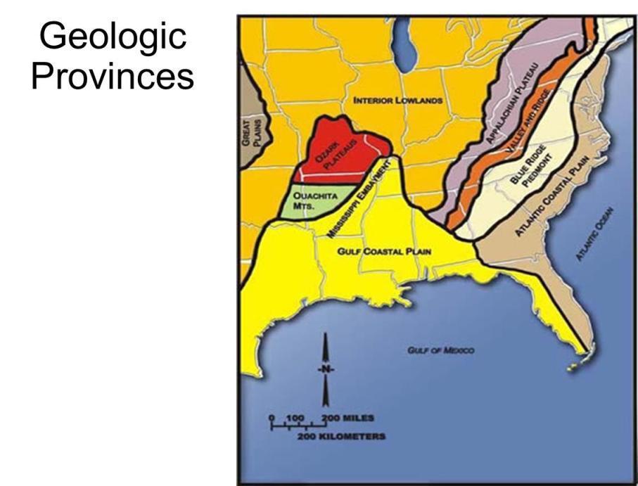
2 THE APPALACHIANS & THE OZARKS
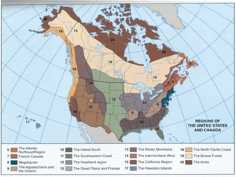
3
4 Setting the Boundaries What states and provinces are part of the region? Eastern TN, western NC, eastern KY, western VA, West Virginia, western MD, southeastern OH, eastern PA, southern NY Northwestern AR, southern MO What regions does it border? Great Plains, Heartland, Inland South, Megalopolis, Atlantic Northeast
5
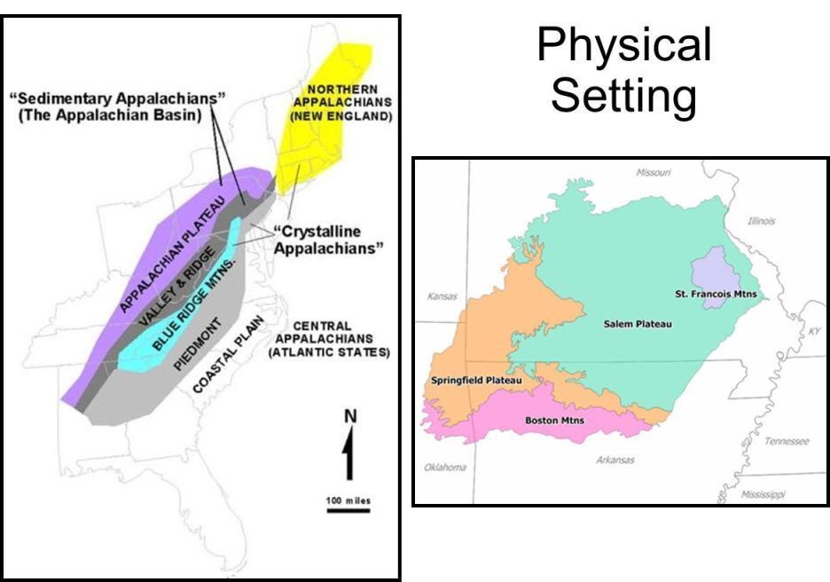
6 Overview Mountainous Rural Economically disadvantaged Recent growth in southern areas
7 Physical Geography
8

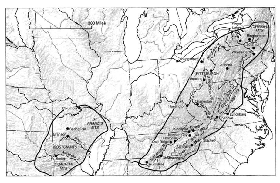
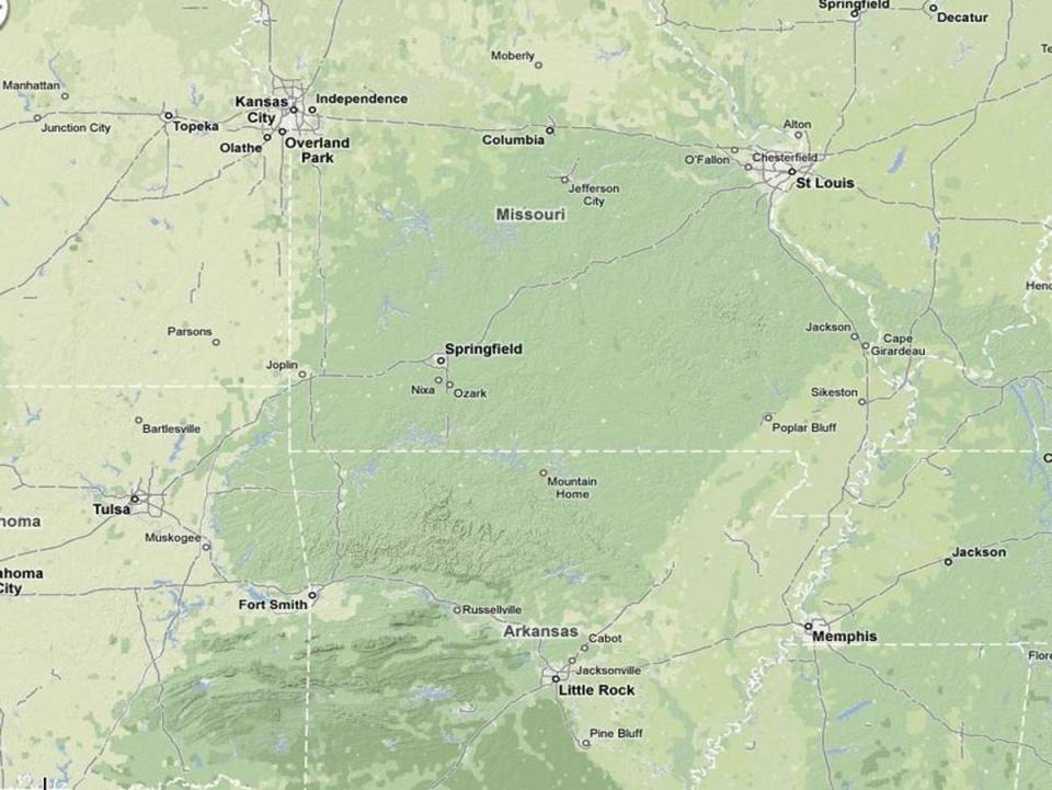
9 Blue Ridge - Smokies Pennsylvania to Georgia Narrow belt of mountains Mostly forested

10 Ridge & Valley Great Valley from Lehigh to Shenandoah Parallel ridges and valleys to west Grasslands, agriculture in valleys Also mostly forested
11
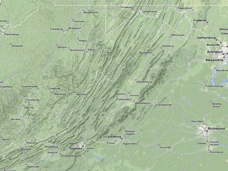
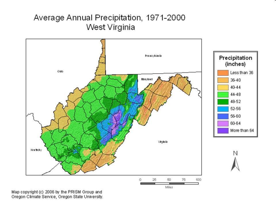
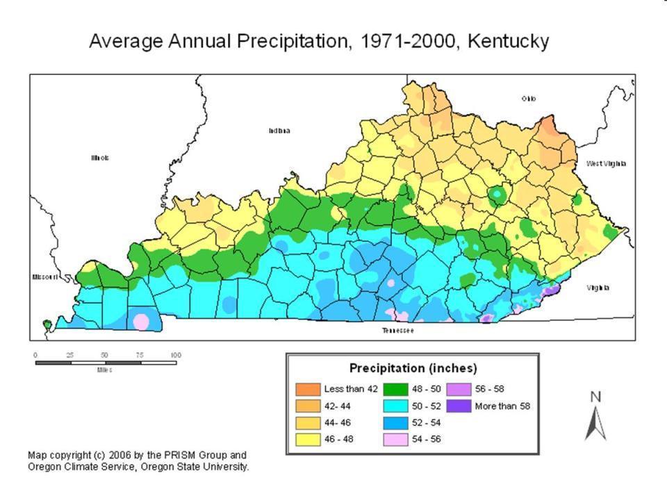
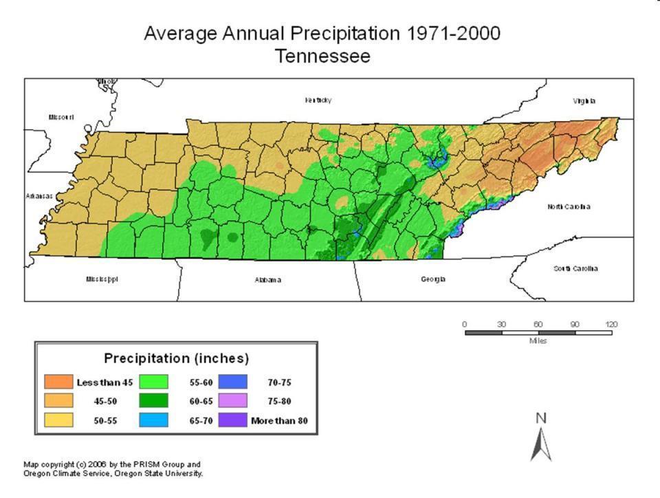
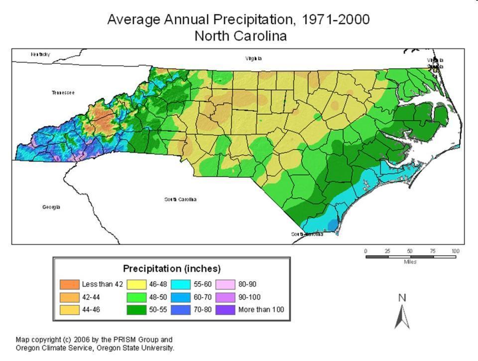
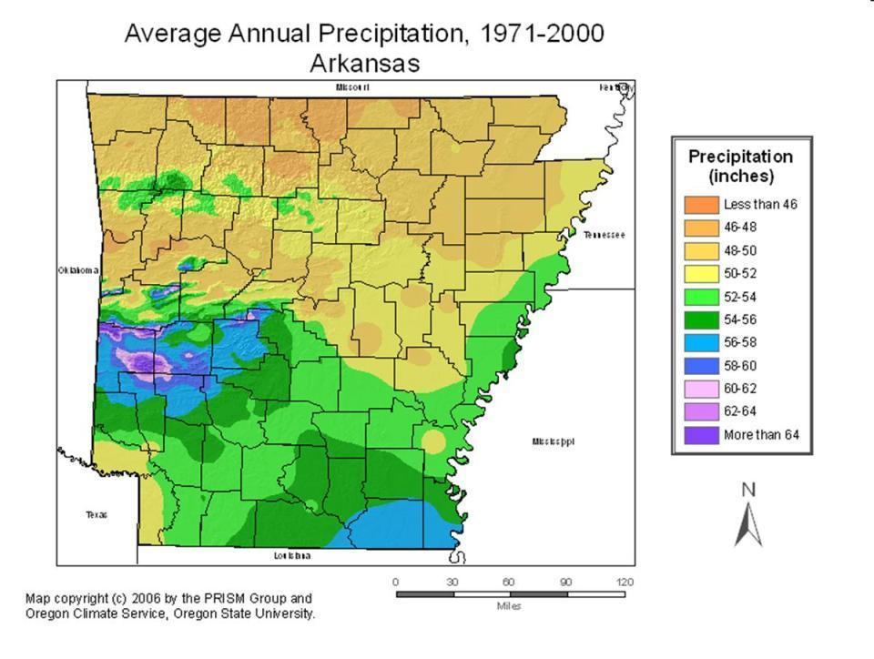
12 Shenandoah Valley

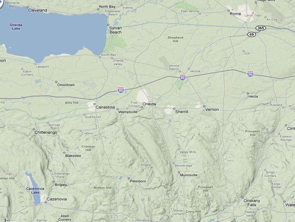
13 Appalachian Plateau Ancient plateau Weathered to hill country More rounded north where glaciated Appalachian Plateau near Oneida, in upstate New York
14
15

16 Ozarks and Ouachitas Ozarks Eroded plateaus like Appalachian Plateau Ouachitas Similar to Ridge and Valley
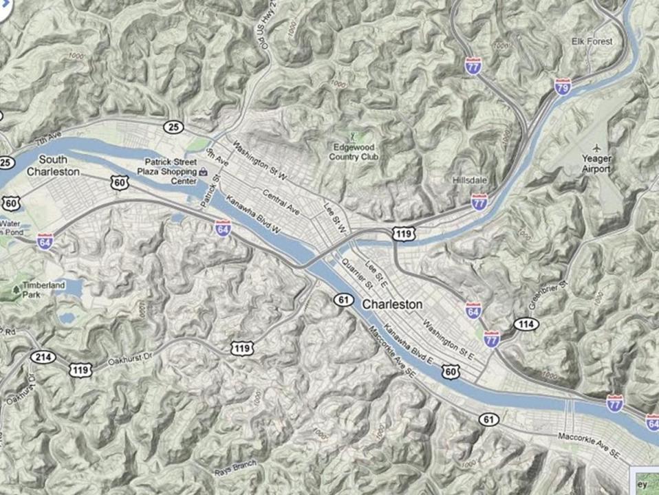
17
18
19 Climate Humid Much precipitation year-round Snowier farther north and higher elevation Fog prone Longer growing season in south
20
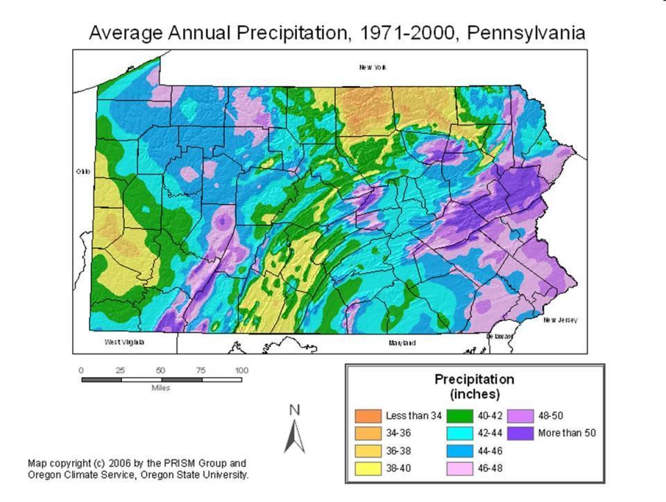
21
22 Climograph Pittsburgh, PA
23
24 Climograph Charleston, WV
25
26
27
28 Climograph Ashville, NC
29
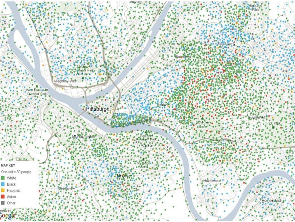
30 Climograph Fort Smith, AR
31 Climate Comparison Spokane WA Pittsburgh PA Asheville NC Ft. Smith AR Jan Temp (F) 33 / / / / 27 Jul Temp (F) 82 / / / / 71 Rainfall 16.5 in. 36 in. 48 in. 40 in. Snowfall 49 in. 44 in. 17 in. 7 in.
32 Population & Settlement
33 Appalachian Settlement Settlement began in Pennsylvania, early 1700 s Great Valley first Settlement of mountainous areas began in late 1700 s 1800 s Scots, Irish, Germans
34 Ozark Settlement Early French Settlement in 1700 s After Louisiana purchase, British settlement began in earnest Valleys first settled, mountains settled later
35 Presently Most population of British decent Some African-American concentrations in larger towns Large exodus beginning in WWI with industrial decline Recent dichotomy S. Appalachians, Ozarks growth (retirement, tourism) N. Appalachians, continued decline
36 Population Numbers State/Metro 2000 (1,000 s) 1990 (1,000 s) Change Binghamton, NY % West Virginia 1,808 1,793 +1% Pittsburgh, PA 2,358 2,394-2% Asheville, NC % Huntsville, AL % Springfield, MO % US & Canada 312, , %

37 Population Density NY

38 Population Density PA

39 Population Density WV

40 Population Density VA

41 Population Density TN

42 Population Density NC

43 Population Density AR

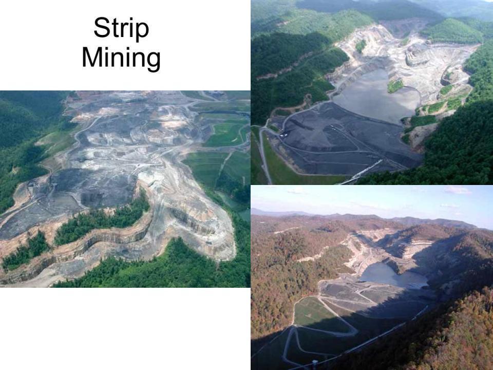
44 Population Density MO

45 Agriculture Small farms Scattered in valleys in hillsides Great Valley very good cropland General farming and livestock Some areas specialize in apples and dairy Tobacco only large cash crop


46 Great Valley It is a gigantic trough a chain of valley lowlands and the central feature of the Appalachian Mountain system.
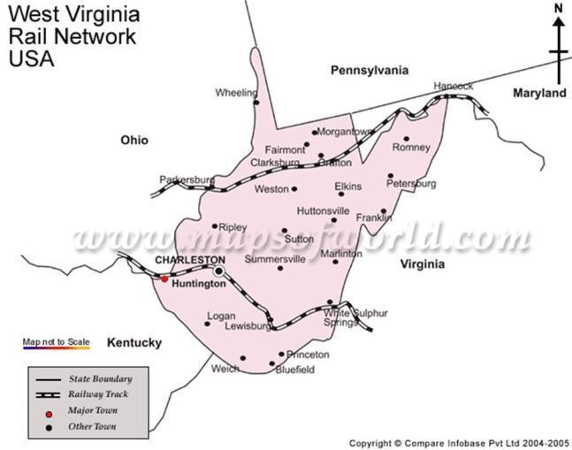
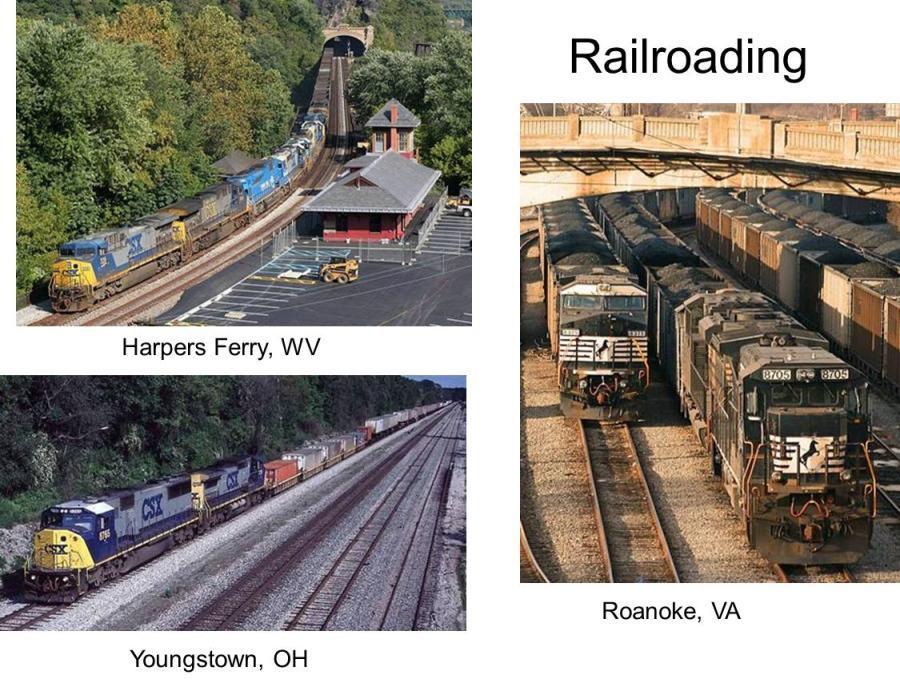
47 Human & Economic Geography
48 Forestry Much land is federally protected Little virgin forest; most second or third generation growth Mostly used for lumber Scattered through many small enterprises
49 Mining Much of Appalachians & Ozarks underlain by bituminous coal Northeastern Pennsylvania: Anthracite coal Two-thirds of US production here Largest domestic energy resource 300 years remaining
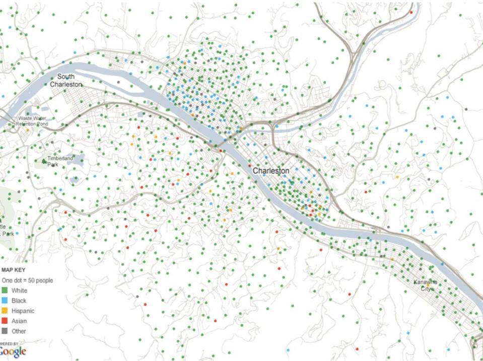
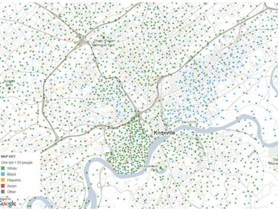
50 Mining Zigzag of use over time Early century: railroads, domestic Later part: electricity generation Increased efficiency over time Coal more feasible competition Fewer workers needed 750,000 in 1910 s 150,000 now
51 Strip Mining Easier (and safer) to remove mountain top and expose coal Controversy as an environmental problem Exposes soils to weathering, compaction, erosion, and chemical alteration Complete removal of original flora and fauna Alteration of surface and groundwater systems Transport of toxic substances to the surface Dramatic alteration of the original landscape and geologic profile
52
53 Mining Petroleum Upstate New York, Pennsylvania, & Kentucky Only 2% of domestic production Copper and Zinc Tennessee, Missouri
54 Railroading
55
56 Tourism & Recreation North: recreation area for Megalopolis Penn: also Civil War area Great Smoky Mountains Nat l Park, most visited national park in the US Ozarks: Branson, MO; only nearby mountains to southerners Southern Appalachians and Ozarks: new retirement haven
 Still declining after steel/coal decline Reinvention as high-tech industrial center Knoxville, Scranton,")
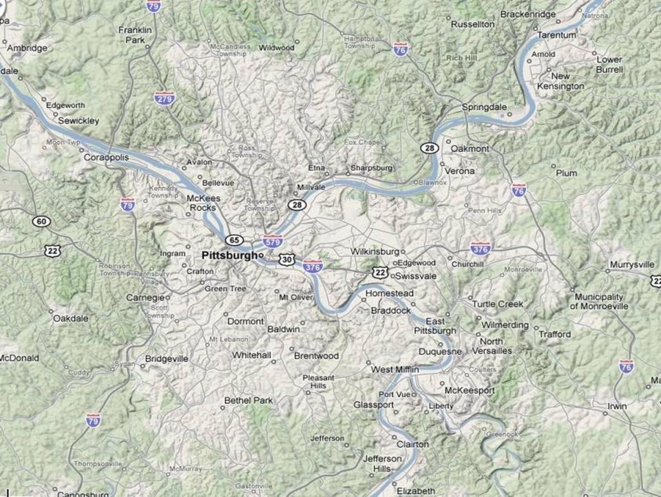
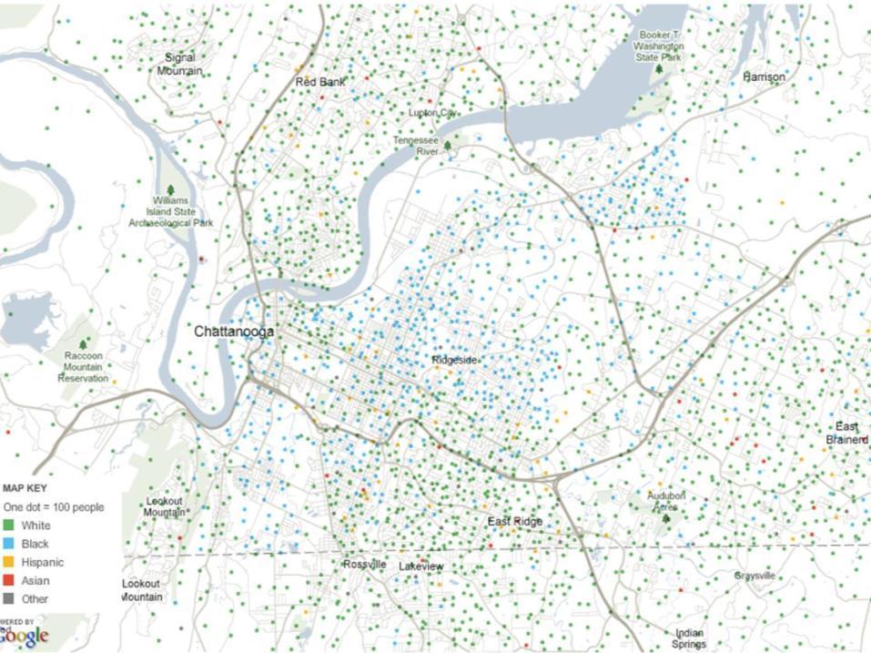
57 Cities One of the least urbanized areas in N.A. Pittsburgh only large city (2.3M metro) Still declining after steel/coal decline Reinvention as high-tech industrial center Knoxville, Scranton, Youngstown, Chattanooga Only other metro areas over 500,000
58
59
60
61
62
63
64
65
All of Virginia's 4 main rivers flow into the... Chesapeake Bay. Along which river would Jamestown be found? James River. Appalachian Mountains
 All of Virginia's 4 main rivers flow into the... Along which river would Jamestown be found? The Blue Ridge Mountains and Valley and Ridge are part of what large mountain system? Define climate. Define
Regional Geography C. LANGDON WHITE. Professor Emeritus Stanford University EDWIN J. FOSCUE TOM L. MCKNIGHT
 Regional Geography of Anglo-America Sixth Edition C. LANGDON WHITE Professor Emeritus Stanford University EDWIN J. FOSCUE Late of Southern Methodist University TOM L. MCKNIGHT Professor of Geography University
4 th Grade Virginia Studies SOL Review Packet Geography of Virginia. 1. The Algonquian language group of Indians lived in what region of Virginia?
 4 th Grade Virginia Studies SOL Review Packet Geography of Virginia 1. The Algonquian language group of Indians lived in what region of Virginia? A. Allegheny B. Piedmont C. Ridge and Valley D. Tidewater
Virginia Regions Study Guide
 Name/Number: Date: Virginia Regions Study Guide Standard VS.2a: SWBAT demonstrate knowledge of the physical geography and native peoples, past and present, of Virginia by locating Virginia and its bordering
Physical Geography of the United States and Canada Chapter 5 A Land of Contrasts
 Physical Geography of the United States and Canada Chapter 5 A Land of Contrasts Land Area Together the U.S. and Canada cover more than 7 million square miles. In total area, Canada ranks 2 nd and the
Module 10: Resources and Virginia Geology Topic 4 Content: Virginia Geology Notes
 Virginia is composed of a very diverse landscape that extends from the beaches and barrier islands all of the way to the highly elevated Appalachian Plateau. Geologists have discovered ancient shallow
Explain the impact of location, climate, natural resources, and population distribution on Europe. a. Compare how the location, climate, and natural
 SS6G10 Explain the impact of location, climate, natural resources, and population distribution on Europe. a. Compare how the location, climate, and natural resources of Germany, the United Kingdom and
Geography Terms. Work with your desk partner, using your technology, to define and illustrate each term.
 Geography Terms Work with your desk partner, using your technology, to define and illustrate each term. 1. Continent 2. Hemisphere 3. Nation 4. Absolute location 5. Relative location 6. Latitude 7. Longitude
Life East of the Mississippi
 Life East of the Mississippi Physical Features ESSENTIAL QUESTION: How does geography influence the way people live? ~The United States can be divided into regions based on physical characteristics. Learning
Socials Studies. Chapter 3 Canada s People 3.0-Human Geography
 Socials Studies Chapter 3 Canada s People 3.0-Human Geography Physical Geography Study of the natural features of the Earth s surface including landforms, climate, ocean currents and flora and fauna Human
Unit 1: Geography. For additional information, refer to this website: 1 G e o g r a p h y
 Unit 1: Geography For additional information, refer to this website: http://mryoungtms.weebly.com/ 1 G e o g r a p h y Continents and Oceans SOL USI. 2a Essential Understanding: Continents are large land
2 Georgia: Its Heritage and Its Promise
 TERMS region, erosion, fault, elevation, Fall Line, aquifer, marsh, climate, weather, precipitation, drought, tornado, hurricane, wetland, estuary, barrier island, swamp PLACES Appalachian Mountains, Appalachian
GUIDED READING CHAPTER 1: THE LAY OF THE LAND (Page 1)
") CHAPTER 1: THE LAY OF THE LAND (Page 1) Section 1 The Tidewater Region Directions: Use the information from pages 6-11 to complete the following statements. 1. In the southern part of the coast, the Tidewater
CHAPTER 1: THE LAY OF THE LAND (Page 1) Section 1 The Tidewater Region Directions: Use the information from pages 6-11 to complete the following statements. 1. In the southern part of the coast, the Tidewater
Standards Content Skills/Competency Assessment A:
 4 th Grade Course Title: Social Studies Month: Sept., & Oct Big Ideas/Enduring Understandings The political, economic, historical and geographic development of Pennsylvania is a model of the pattern for
The United States & Canada. A Regional Study of Anglo America
 A Regional Study of Anglo America Landform Regions of the United States & Canada world leaders in agricultural and industrial production because of... VAST LANDS stretch from the Atlantic Ocean on the
3 rd Grade Social Studies Pacing Guide Arkansas Frameworks
 3 rd Grade Social Studies Pacing Guide Arkansas Frameworks 1st Nine Weeks Strand1: Geography Standard 1: Physical and Spatial Students shall develop an understanding of the physical and spatial characteristics
Locations of Monitoring Stations in the Mercury Trends Network
 Locations of Monitoring Stations in the Mercury Trends Network Three sets of geographic criteria were used to determine the locations for the regionally representative MTN monitoring stations: ecoregion,
EXAM INFORMATION. Appalachia and The Ozarks OVERVIEW. Regional Landscape Studies. Appalachians and The Ozarks
 EXAM INFORMATION Exam Two will be Tuesday, April 12. Format same as Exam 1. Multiple choice short answer including maps plus choice of essay topics. See Study Guide. Missed exam make-up is all essay format.
MARS AREA SCHOOL DISTRICT CURRICULUM GRADE: Grade 4
 MARS AREA SCHOOL DISTRICT CURRICULUM GRADE: Grade 4 Course Title: Social Studies Brief Description Overview: Students will explore the history, geography, government, and economy of the United States with
Introducing North America
 Introducing North America I. Quick Stats Includes U.S. & Canada U.S consists of 50 States Federal Government Democracy 4 th in world w/ land area 3 rd in population Economic leader of free world II. Major
discussion of North America s physical features, including its landforms and bodies of
 Chapter 7 Natural Environments of North America Chapter 7 focuses on the natural environments of North America. The chapter opens with a discussion of North America s physical features, including its landforms
The Driftless Area. Dave Speer Geography 326
 The Driftless Area Dave Speer Geography 326 Introduction: Wisconsin s landscape is defined by many physical features resulting from continental glaciation. Wisconsin is unique in the fact that it possesses
Topography of the conterminous United States
 Topography of the conterminous United States Potential Natural Vegetation Geology Coastal Ranges physiographic province Cascade-Sierra Mountains Cascades Mount Hood California central valley Sierra-Nevada
Terrain Units PALEOGEOGRAPHY: LANDFORM CREATION. Present Geology of NYS. Detailed Geologic Map of NYS
 NYS TOPOGRAPHY Why so? PALEOGEOGRAPHY: LANDFORM CREATION Prof. Anthony Grande AFG 014 Present Geology of NYS Detailed Geologic Map of NYS Generalized Geology Detailed Geology Hot links to the fold out
Grade 7 History Mr. Norton
 Grade 7 History Mr. Norton Section 1: Thinking Geographically Section 2: Land and Climates of the United States Section 3: The Tools of History Section 4: Economics and Other Social Sciences Grade 7 History
Guided Reading Activity
 Guided Reading Activity Lesson 1 Physical Features Essential Question: How does geography influence the way people live? A Vast Land Directions: Read the lesson and use your text to decide whether each
EXAM INFORMATION. Appalachia and The Ozarks OVERVIEW. Regional Landscape Studies 4/4/2017. Regional Landscapes of the United States and Canada
 EXAM INFORMATION Exam Two will be Friday, April 7. Format same as Exam 1 Covers regions from Northlands to Appalachia including Canada s National Core. The Extra Credit for Multiple choice questions Exam
Definitions Weather and Climate Climates of NYS Weather Climate 2012 Characteristics of Climate Regions of NYS NYS s Climates 1.
 Definitions Climates of NYS Prof. Anthony Grande 2012 Weather and Climate Weather the state of the atmosphere at one point in time. The elements of weather are temperature, t air pressure, wind and moisture.
WEATHER NOTIFICATION STATEMENT
 WEATHER NOTIFICATION STATEMENT NEW DATA SHOWS SNOWSTORM THREAT FOR JAN 13-14 LOOKS MUCH HEAVIER BIGGER COVERAGE northwest NC (ice) ALL OF VA (Except Hampton Roads) all of MD/ DEL eastern southern PA southern
Social Studies Curriculum Document Grade 3 Alignment with Common Core Unit 1 Student Learning Expectation
 Social Studies Curriculum Document Grade 3 Alignment with Common Core Unit 1 Student Learning Enduring Understanding: Good citizenship should be evident by observing proper etiquette of the American flag.
Climate. Annual Temperature (Last 30 Years) January Temperature. July Temperature. Average Precipitation (Last 30 Years)
 January Temperature. July Temperature. Average Precipitation (Last 30 Years)") Climate Annual Temperature (Last 30 Years) Average Annual High Temp. (F)70, (C)21 Average Annual Low Temp. (F)43, (C)6 January Temperature Average January High Temp. (F)48, (C)9 Average January Low Temp.
Climate Annual Temperature (Last 30 Years) Average Annual High Temp. (F)70, (C)21 Average Annual Low Temp. (F)43, (C)6 January Temperature Average January High Temp. (F)48, (C)9 Average January Low Temp.
Most people used to live like this
 Urbanization Most people used to live like this Increasingly people live like this. For the first time in history, there are now more urban residents than rural residents. Land Cover & Land Use Land cover
Locate places on contemporary maps using cardinal and intermediate directions, map scales, legends, and t
 Subject Grade Level 3 Social Studies G.1.3.1 G.1.3.10 G.1.3.11 G.1.3.12 G.1.3.13 G.1.3.14 G.1.3.15 G.1.3.2 G.1.3.3 G.1.3.4 G.1.3.5 G.1.3.6 G.1.3.7 G.1.3.8 G.1.3.9 Define absolute location Describe how
Markville. CGC 1DL/PL Geography. Geography of Canada. Natural Environment Unit Test
 Markville CGC 1DL/PL Geography Geography of Canada Natural Environment Unit Test Name: Thinking /10 Knowledge /10 Application /10 Communication /10 Part A: Blanks (1 mark each) Thinking Choose the correct
EQ: Discuss main geographic landforms of the U.S. & Canada and examine varied landforms in relation to their lifestyles.
 EQ: Discuss main geographic landforms of the U.S. & Canada and examine varied landforms in relation to their lifestyles. Places & Terms for Discussion Appalachian Mountains Great Plains Canadian Shield
NEW YORK S NATURAL WONDERS
 Landscapes and Drainage Patterns NEW YORK S NATURAL WONDERS New York is not one of the largest states of the United States, nor does it have any large national parks to rival Yosemite or the Grand Canyon.
H i s t o r y G e o g r a p h y G o v e r n m e n t E c o n o m y
 H i s t o r y G e o g r a p h y G o v e r n m e n t E c o n o m y Grading Policy Informal assessments: 45% Examples: homework, classwork, terms, notebooks Formal assessments: 45% Examples: chapter/unit
Five Themes of Geography Project Ms. Kiesel, Per 5. The United States of America
 Five Themes of Geography Project Ms. Kiesel, Per 5 The United States of America Location Absolute Location : The USA is located in the continent of North America in the northern and western hemispheres.
Platt s 22 nd Annual Coal Properties And Investment
 Platt s 22 nd Annual Coal Properties And Investment Demand and Production of Thermal and Met Coal Palm Beach Gardens, Florida March 17 18, 2014 Alan K. Stagg Stagg Resource Consultants, Inc. U.S Metallurgical
Sec$on 1: Geography and Early China. How does China s geography affect the culture?
 Sec$on 1: Geography and Early China How does China s geography affect the culture? Con$nents of the World Label the continents. Where is China located? Where is China located? In your groups, begin filling
Answers to Northwest Territories Quizzes
 Answers to Northwest Territories Quizzes p. 1 Test Your Knowledge What do you remember from your review of the Northwest Territories section of the E-Atlas? 1. The first people to inhabit the Northwest
Continental Landscapes
 Continental Landscapes Landscape influenced by tectonics, climate & differential weathering Most landforms developed within the last 2 million years System moves toward an equilibrium Continental Landscapes
3/5/05 Dr. Stewart 1
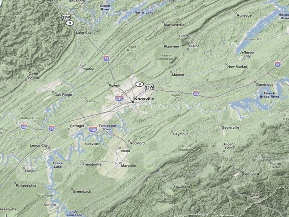
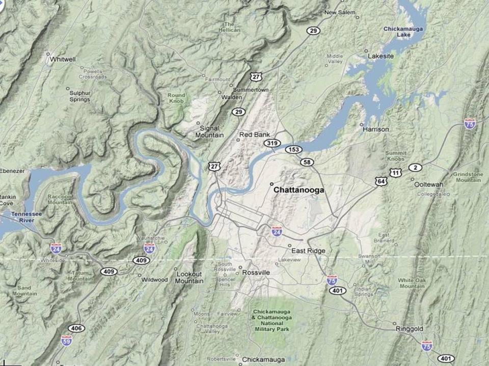
 I. Physiography of Appalachian Mountains A. Introduction 1. These mountains extend from NE Canada to Georgia 2. They are the remains of a deeply eroded, ancient mountain chain once larger than the Himalayans
TOPOGRAPHIC RELIEF MAP of NYS. LANDFORMS of NYS. Landforms. Creation of NYS Landforms 9/22/2011
 TOPOGRAPHIC RELIEF MAP of NYS LANDFORMS of NYS Prof. Anthony Grande AFG 2011 Landforms The basis of present-day landforms (surface features) is the bedrock geology that has been worked on by the forces
PALEOGEOGRAPHY of NYS. Definitions GEOLOGIC PROCESSES. Faulting. Folding 9/6/2012. TOPOGRAPHIC RELIEF MAP of NYS GRADATIONAL TECTONIC
 TOPOGRAPHIC RELIEF MAP of NYS PALEOGEOGRAPHY of NYS Prof. Anthony Grande AFG 2012 Definitions GEOLOGIC PROCESSES Geography: study of people living on the surface of the earth. Geology: the scientific study
Climates of NYS. Definitions. Climate Regions of NYS. Storm Tracks. Climate Controls 10/13/2011. Characteristics of NYS s Climates
 Definitions Climates of NYS Prof. Anthony Grande 2011 Weather and Climate Weather the state of the atmosphere at one point in time. The elements of weather are temperature, air pressure, wind and moisture.
Natural Texas. Regions and Climates
 Natural Texas Regions and Climates Two Kinds: Physical geography Climate, vegetation, rivers, lakes, oceans, plateaus, plains, and mountain ranges Human geography Economic activities How we earn a living
Your web browser (Safari 7) is out of date. For more security, comfort and the best experience on this site: Update your browser Ignore
 is out of date. For more security, comfort and the best experience on this site: Update your browser Ignore") Your web browser (Safari 7) is out of date. For more security, comfort and the best experience on this site: Update your browser Ignore urban area For the complete encyclopedic entry with media resources,
Your web browser (Safari 7) is out of date. For more security, comfort and the best experience on this site: Update your browser Ignore urban area For the complete encyclopedic entry with media resources,
Social Studies. Chapter 2 Canada s Physical Landscape
 Social Studies Chapter 2 Canada s Physical Landscape Introduction Canada s geography its landforms and climate - has a great impact on Canadians sense of identity. Planet Earth The earth is divided into
Monday September 11, 2017
 Monday September 11, 2017 Need: 9/11 Interview Paper Agenda: Good things Warm Up: Video and Reflection Circles Sharing Interview Stories Discussion Questions Whole group sharing Summarizer: Living in a
Physiographic Provinces (West, Ch. 13)
") Geology 229 Engineering Geology Lecture 13 Physiographic Provinces (West, Ch. 13) The definition of the term Physiography Physiography (n.) The science which treats of the earth's exterior physical features,
Geology 229 Engineering Geology Lecture 13 Physiographic Provinces (West, Ch. 13) The definition of the term Physiography Physiography (n.) The science which treats of the earth's exterior physical features,
4th Grade U.S. Regional Geography
 4th Grade U.S. Regional Geography Multiple Choice Identify the choice that best completes the statement or answers the question. What does the term mainland mean in the sentence above? A the continent
Chapter 2. Regional Landscapes and the Hydrologic Cycle
 Chapter 2. Regional Landscapes and the Hydrologic Cycle W. Lee Daniels Department of Crop and Soil Environmental Sciences, Virginia Tech Table of Contents Introduction... 23 Soils and landscapes of the
Landforms in Canada. Canada is made up of three dis;nct types of landforms: Canadian Shield Highlands Lowlands
 Canada s Landforms What is a Landform? A landform is any physical feature of the Earth s surface having a characteris;c, recognizable shape, produced by natural causes. Landforms include major features
Changes in Texas Ecoregions
 Comment On Lesson Changes in Texas Ecoregions The state of Texas can be divided into 10 distinct areas based on unique combinations of vegetation, topography, landforms, wildlife, soil, rock, climate,
Description DESCRIPTION
 DESCRIPTION The location of the Upper James Watershed is located in northeastern South Dakota as well as southeastern North Dakota. It includes the following counties located in North Dakota Barnes, Dickey,
Earth Science. STREAM DRAINAGE PATTERNS (start by reading the first page of these notes!)
") Name _ Earth Science STREAM DRAINAGE PATTERNS (start by reading the first page of these notes!) WHAT IS A DRAINAGE PATTERN? Streams seek the lowest path as they move downhill, and they tend to erode their
Name _ Earth Science STREAM DRAINAGE PATTERNS (start by reading the first page of these notes!) WHAT IS A DRAINAGE PATTERN? Streams seek the lowest path as they move downhill, and they tend to erode their
Chapter 3. Description of the Study Area. Karl Taboga, James Stafford and Paul Taucher 3-19
 Chapter 3 Description of the Study Area Karl Taboga, James Stafford and Paul Taucher 3-19 T his study examines groundwater resources that underlie the Bear River drainage basin in Wyoming as well as areas
5th social studies geography (5thsocstud_geography)
") Name: Date: 1. Many of the Native Americans who lived on the Great Plains were nomadic people. Why did they move from place to place? A. They were finding new areas to mine. B. They were looking for fertile
Name: Date: 1. Many of the Native Americans who lived on the Great Plains were nomadic people. Why did they move from place to place? A. They were finding new areas to mine. B. They were looking for fertile
Factors Affecting Human Settlement
 Factors Affecting Human Settlement Physical Factors One of the most basic factors affecting settlement patterns is the physical geography of the land. Climate is key, because if a place is too dry, too
Unit 1: Geography GeoTrekkers in the Western Hemisphere. Illustrated Glossary
 Unit 1: Geography GeoTrekkers in the Western Hemisphere Illustrated Glossary adapt to change in order to fit new condi/ons archipelago a group or chain of islands clustered together in a sea or ocean bodies
Geography and the Early Settlement of China
 Geography and the Early Settlement of I N T E R A C T I V E S T U D E N T N O T E B O O K How did geography affect life in ancient? P R E V I E W Physical Features 1. Circle the physical features that
GEOGRAPHY OF THE UNITED STATES & CANADA. By Brett Lucas
 GEOGRAPHY OF THE UNITED STATES & CANADA By Brett Lucas THE INTERMONTANE WEST Setting the Boundaries What states and provinces are part of the region? Parts of WA, OR, ID, CA, UT, NM. All of NV and AZ.
UNIT4. Ancient China. Geography and the Early Settlement of China. Three Chinese Philosophies The First Emperor of China
 UNIT4 Ancient China Lesson 19 Lesson 20 Lesson 21 Lesson 22 Lesson 23 Lesson 24 Geography and the Early Settlement of China The Shang Dynasty Three Chinese Philosophies The First Emperor of China The Han
Borchert s Epochs of American Urbanization
 Borchert s Epochs of American Urbanization Geographers define cities as intersecting points of communication and transportation. Cities serve multiple social, political, economic and cultural purposes.
Revised February 9, 2017
 Revised February 9, 2017 Geography of the U.S. II-A-1* Apply geographic tools of title, grid system, legends, symbols, scale and compass rose to construct and interpret maps. II-A-2* Translate geographic
Geography - US and Canada Review
 Class: Date: Geography - US and Canada Review Multiple Choice Identify the choice that best completes the statement or answers the question. KEY GEOGRAPHIC CONCEPTS AND SKILLS 1. All of the following landforms
4th Grade Social Studies First Nine Weeks
 4th Grade Social Studies First Nine Weeks Multiple Choice Identify the choice that best completes the statement or answers the question. 1 Name the mountains that are located in the eastern United States.
LATITUDE. Latitude lines run to, but are measured & The 0 of latitude that circles the earth is called the?
 LATITUDE Latitude lines run to, but are measured & The 0 of latitude that circles the earth is called the? LATITUDE 0 0 Latitude lines run east to west, but are measured north & south The 0 of latitude
What is the largest country in the world? Russia
 What is the largest country in the world? #1 Russia CSCOPE 2007 2 Russia Dimensions #2-3 Spans 11 Time Zones From East to West: Gulf of Finland to Alaska From North to South: Above the Arctic Circle to
Landform Regions of Canada
 Landform Regions of Canada The movement of the earth s plates, and the resulting folding, faulting, and volcanic activity, have combined with the forces of erosion and weathering to create a variety of
2. PHYSICAL SETTING FINAL GROUNDWATER MANAGEMENT PLAN. 2.1 Topography. 2.2 Climate
 FINAL GROUNDWATER MANAGEMENT PLAN 2. PHYSICAL SETTING Lassen County is a topographically diverse area at the confluence of the Cascade Range, Modoc Plateau, Sierra Nevada and Basin and Range geologic provinces.
LANDFORMS of NYS. Landforms. Exercise 4 9/13/2012. TOPOGRAPHIC RELIEF MAP of NYS. Physiographic map of NYS and vicinity showing Surface Features
 TOPOGRAPHIC RELIEF MAP of NYS LANDFORMS of NYS Prof. Anthony Grande AFG 2012 Landforms REMINDER: The basis of present-day landforms (surface features) is the bedrock geology that has been worked on by
CHAPTER 1: EXPLORING GEOGRAPHY
 CHAPTER 1: EXPLORING GEOGRAPHY Please Do Now: In your PDN section of your binder answer the following with one or two sentences: What is Geography? What is Geography? The study of where people, places,
Chapter 52: An Introduction to Ecology and the Biosphere
 AP Biology Guided Reading Name Chapter 52: An Introduction to Ecology and the Biosphere Overview 1. What is ecology? 2. Study Figure 52.2. It shows the different levels of the biological hierarchy studied
Chapter 32. Australia & New Zealand
 Chapter 32 Australia & New Zealand Lesson 1: Physical Geography of Australia & New Zealand Landforms Australia lies between the Pacific and Indian Oceans in the Southern Hemisphere. Although an island,
Landscape evolution. An Anthropic landscape is the landscape modified by humans for their activities and life
 Landforms Landscape evolution A Natural landscape is the original landscape that exists before it is acted upon by human culture. An Anthropic landscape is the landscape modified by humans for their activities
Unit 1: Geography CLASS WEBSITE: QUIZLET GAMES: ONLINE RESOURCES
 Unit 1: Geography ONLINE RESOURCES CLASS WEBSITE: HTTPS://MRYOUNGTMS.WEEBLY.COM/GEOGRAPHY.HTML QUIZLET GAMES: HTTPS://QUIZLET.COM/JOIN/MSFYY94T5 1 G e o g r a p h y Continents and Oceans The Seven Continents
PHYSIOGRAPHIC REGIONS OF THE LOWER 48 UNITED STATES
 PHYSIOGRAPHIC REGIONS OF THE LOWER 48 UNITED STATES LAURENTIAN UPLAND 1. Superior Upland ATLANTIC PLAIN 2. Continental Shelf (not on map) 3. Coastal Plain a. Embayed section b. Sea Island section c. Floridian
What are the geographic tools and how are they used to identify phisical and human features of a location?
 Teacher / Team Name: 4th Grade - Social Studies Topic: 1 - Geography 2011 Social Studies Days: 25 4th Key Learning: Geographic tools help us identify physical and human features of the world in which we
UNITED STATES AND SOUTH AMERICA OUTLOOK (FULL REPORT) Wednesday, April 18, 2018
 Wednesday, April 18, 2018") T-storm Weather Summary Coolness continues over the next week in much of the central U.S., most likely producing the coldest April since 1907 in the Corn Belt, but followed by seasonable to mild weather
T-storm Weather Summary Coolness continues over the next week in much of the central U.S., most likely producing the coldest April since 1907 in the Corn Belt, but followed by seasonable to mild weather
The study of Geography and the use of geographic tools help us view the world in new ways.
 S How does Geography help us understand our world? What factors shape the Earth s different environments? 7.1.9 7.2.9 BIG IDEAS COMPETENCIES Text pages or The study of Geography and the use of geographic
312 - GEOGRAPHY INTRODUCTION GENERAL OBJECTIVES
 312 - GEOGRAPHY GENERAL OBJECTIVES By the end of the course, the learner should be able to: 1. appreciate the importance of studying Geography; 2. recognize different types of environments and manage them
Which landscape best represents the shape of the valleys occupied by glaciers? A) B) C) D)
 B) C) D)") 1. Glaciers often form parallel scratches and grooves in bedrock because glaciers A) deposit sediment in unsorted piles B) deposit rounded sand in V-shaped valleys C) continually melt and refreeze D) drag
1. Glaciers often form parallel scratches and grooves in bedrock because glaciers A) deposit sediment in unsorted piles B) deposit rounded sand in V-shaped valleys C) continually melt and refreeze D) drag
PHYSICAL GEOGRAPHY: An overview. Definitions. Faulting. Folding GEOLOGIC PROCESSES 9/17/2013 TOPOGRAPHIC RELIEF
 TOPOGRAPHIC RELIEF PHYSICAL GEOGRAPHY: An overview Prof. Anthony Grande AFG 0913 2 Definitions GEOLOGIC PROCESSES Geography: Study of people living on the surface of the earth. Geology: the study of the
Key City Focus: Metro Tampa-St Petersburg
 Key City Focus: Metro Tampa-St Petersburg Tallahassee Jacksonville Orlando Tampa Miami Lakeland Clearwater Tampa St Petersburg Bradenton 1 Carriage Pointe: Mini Case Study The previous picture is from
Chapter 1 Study Guide
 Chapter 1 Study Guide Reminders: Vocabulary quiz and test will be on Tuesday, September 6th. Complete study guide and bring completed to school Friday, September 2nd. You are NOT required to print the
Global Climates. Name Date
 Global Climates Name Date No investigation of the atmosphere is complete without examining the global distribution of the major atmospheric elements and the impact that humans have on weather and climate.
Amazing Canada Project! By Matthew Shim
 Amazing Canada Project! By Matthew Shim All Regions in Canada The Cordillera The Interior Plains The Canadian Shield The St. Lawrence Lowlands The Appalachians The Arctic Location Cordillera Location North
LANDFORM REGIONS IN CANADA. Classroom Notes and Descriptions
 LANDFORM REGIONS IN CANADA Classroom Notes and Descriptions Landform Regions in Canada There are eight distinct landforms in Canada: Western Cordillera Region Interior Plains Canadian Shield Hudson Bay
Chapter 32. Australia & New Zealand
 Chapter 32 Australia & New Zealand Lesson 1: Physical Geography of Australia & New Zealand Landforms Australia lies between the Pacific and Indian Oceans in the Southern Hemisphere. Although an island,
Australia and New Zealand: Powerpoint
 Australia and New Zealand: Powerpoint Physical Geography Australia and New Zealand are between the Indian and Pacific Oceans. Australia s seasons are opposite of the United States due to their location.
Unit 2. United States Physical Geography
 Unit 2 United States Physical Geography Physical Geography U.S. extends from the Atlantic to Pacific U.S. is the 3rd largest country U.S. has fertile soils, vast forests, and variety of minerals All major
World Industrial Regions
 World Industrial Regions North America Industrialized areas in North America Changing distribution of U.S. manufacturing Europe Western Europe Eastern Europe East Asia Manufacturing Regions Fig. 11-3:
Name three countries in Europe.
 Name three countries in Europe. I will be able to identify the 5 themes of geography for Europe and locate the countries and capitals of Europe and the major physical features. People: Past: Through the
Groundwater Resources of Missouri. Cynthia Brookshire, R. G.
 Groundwater Resources of Missouri Cynthia Brookshire, R. G. GROUNDWATER... Water beneath the Earth s surface within a zone of saturation AQUIFER... A geologic formation or group of formations that are
PERCEPTION and Focus on Maps. Focus on Maps 8/29/2014. English and Dutch Maps from the 1600s and 1680 British Maps of N. Am.
 PERCEPTION English and Dutch Maps from the 600s The Nature of New York Dutch67 Prof. Anthony Grande English 67 Copyright 04 AFG 676 and 680 British Maps of N. Am. 70 and 776 4 Focus on Maps Maps are geographers
Grade Five Social Studies Assessment Regions/Native Americans
 Name Grade Five Social Studies Assessment Regions/Native Americans Use the map below to answer questions 1 and 2 1. (Geo 1) For this location give the name of the city found there. 38 N, 100 W a. Scottsbluff
Heavy rains and precipitable water anomalies August 2010 By Richard H. Grumm And Jason Krekeler National Weather Service State College, PA 16803
 Heavy rains and precipitable water anomalies 17-19 August 2010 By Richard H. Grumm And Jason Krekeler National Weather Service State College, PA 16803 1. INTRODUCTION Heavy rain fell over the Gulf States,
APPENDIX I - AREA PLANS
 ROUTE 37 WEST LAND USE PLAN ROUTE 37 WEST LAND USE PLAN Recent land use decisions and development trends have drawn attention to the land within the Route 37 western by-pass area between Route 50 and