Graham Leonard, Esline Garaebiti, Sylvain Todman, Sandrine Cevuard, Shadrack Welegtabit, Gill Jolly and Steve Sherburn
|
|
|
- Sabrina Ryan
- 5 years ago
- Views:
Transcription


1 Development of a collaborative consistent volcano communication framework in Vanuatu: Hazard maps, education, alert levels, bulletins, signs and procedures. Graham Leonard, Esline Garaebiti, Sylvain Todman, Sandrine Cevuard, Shadrack Welegtabit, Gill Jolly and Steve Sherburn gesline@vanuatu.gov.vu g.leonard@gns.cri.nz
2 A consistent framework for volcanic hazards communication Part of wider 5 year project developing modern telemetered volcano monitoring, data management and interpretation. Collaboration with Vanuatu Meteorological and Geo-hazards Department (VMGD), and the National Disaster Management Office (NDMO) Supported by the New Zealand Aid Programme.
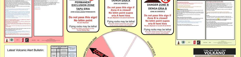
3 Alignment of Hazard maps Background whole island Safety specific location and scenario Danger zones Education Tourism fact sheets Ash impact help Hazard awareness Volcanic Alert Levels Volcanic Alert bulletins Signs and noticeboards Harmonised VGMD and NDMO SoPs
4 DRR options for volcanic hazards Options depend on the hazard, there are several dangerous hazards: Bombs / ballistics (all) Pyroclastic flows (all) Mudflows lahars from crater lake (Gaua and Ambae) Mudflows lahars from rain on ash (All) Distributed vent (cone, maar, lava flow) (Ambae, Ambrym, Gaua) Lava flows (all) Ash and Gas (all)

5 Philosophy: No one hazard map can serve all purposes, timeframes and scenarios Consistency where possible leads to better understanding and effectiveness during crises. A framework of linked materials helps. Communication materials are designed and updated in-house at VMGD and NDMO Assistance has been to help develop the framework and create first versions that can be consulted on, used, and improved in-house
6 Primarily A3 Easy to print in-house (VMGD/NDMO/Resort) Easy to laminate Cheap Likely to be widely used and disseminated Special products (noticeboard etc.) still possible.

7 Hazard maps Background for island Safety for one area


8 Background Show hazard zones Explain what hazards exist in the long term from large eruptions When they may happen What to do at that time


9 Background for: Community awareness Contingency/evacuation planning Strategic/development planning Tourism planning Infrastructure planning Land-use planning

10 Safety map Show safety zones For a specific crisis for a specific part of an island/volcano Link to website for latest zones open/closed


11 Community ash safety Link to education

12 Scenario maps education, and crisis prep.


13 Tourism fact sheet Consistent with safety map Explain the volcano Show safety zones Give safety messages Link to website for latest zones open/closed Separate village sheets? Red Cross posters?


14 And for Ambrym Both edited for correct science content


15 Tourist points of contact consistent info Websites Booking Searching for info At accommodation On transport Laminated At entrance to track Laminated With guide Laminated


16 Volcanic Alert Bulletin Explains new data Gives NDMO zones open/closed message Gives other safety messages of NDMO Gives other VMGD messages like monitoring is ongoing NEEDS harmonised VMGD-NDMO SoPs Needs to help tourism
17 SoP development VMGD Bulletins Alert Level change Notable activity change Ash forecast useful and possible NDMO Safety messages for inclusion in Bulletins Zones open/closed Other safety advice Geohazards operations Normal Small eruption Large eruption

18 Web Integration And clarity NDMO website too


19 Updated alert levels 6 levels Danger zones no longer rigidly linked to levels


20 Example of Ambrym 2015 framework complete

21 Signage, graphic design and community validation Vanuatu Red Cross pilot 2016 Ambrym Danger zone signs Information boards Language and visual elements of maps tailored with local villages
22
23 Thanks!
Situation Report. Situation Overview. Volcanic Activity Ambae & Ambrym. Situation Report 08. Time & Date 17:00 18 th October 2017
 Situation Report Response Name Volcanic Activity Ambae & Ambrym Situation Report 08 Time & Date 17:00 18 th October 2017 Reporting period 18/10/2017 Provinces affected Penama, Sanma, Malampa Attachment(s)
Preparing for Eruptions What will happen in future eruptions and how can we be prepared?
 Lesson Plan 12 Activities 1. Read or listen to Matt s Volcano Story from What s the Plan Stan Stories on: http://www.whatstheplanstan.govt.nz/teacher.html#disasters Discuss what Matt saw and did before,
DISASTER COMMUNICATIONS IN VANUATU
 DISASTER COMMUNICATIONS IN VANUATU ITU/ESCAP Disaster Communications Workshop 12 th 15 th December 2006 Bangkok, THAILAND By: Ms Patricia G. MAWA PSO IT & Engineering Vanuatu Meteorological Service Ministry
Understanding the impacts of an Auckland Volcanic Field eruption on Auckland s infrastructure
 Understanding the impacts of an Auckland Volcanic Field eruption on Auckland s infrastructure Graham Leonard & Natalia Deligne g.leonard@gns.cri.nz Roadmap DEVORA Research programme investigating all matters
Kīlauea Volcano: Be a Volcanologist. Image Credit: Julien Millet / Unsplash. Final Project
 The Kīlauea Volcano: Be a Volcanologist Image Credit: Julien Millet / Unsplash Final Project Final Project The Kīlauea Volcano: Be a Volcanologist In this two-day project, students apply their previous
Guidance for GEOGRAPHY End of Year Examination 2016
 Guidance for GEOGRAPHY End of Year Examination 2016 The End of Year Examination takes place in Week 4 of the Summer Term. The Geography Examination will last 50 minutes. The Examination will include questions
WMO. Key Elements of PWS and Effective EWS. Haleh Haleh Kootval Chief, PWS Programme
 WMO Key Elements of PWS and Effective EWS Haleh Haleh Kootval Chief, PWS Programme Workshop Objectives This workshop is all about Service Delivery and becoming excellent at it through: Sharing experiences
Deterministic Ballistic Hazard Assessment of Mount Ruapehu, New Zealand
 1 2 3 4 5 6 7 8 9 10 11 12 13 14 15 16 17 18 19 20 21 22 23 24 25 26 27 28 29 30 31 32 33 34 35 36 37 38 39 40 41 42 43 44 Frontiers Abroad, New Zealand 10 June 2016 Deterministic Ballistic Hazard Assessment
Public Disclosure Copy
 Public Disclosure Authorized EAST ASIA AND PACIFIC Vanuatu Social, Urban, Rural and Resilience Global Practice Global Practice Recipient Executed Activities Technical Assistance Loan FY 2013 Seq No: 7
Erupted and killed approximately 15,000 people 200 years ago
 1 2 3 4 5 6 7 8 Introduction to Environmental Geology, 5e Chapter 8 Volcanic Activity Volcanoes: summary in haiku form A volcano forms. Magma comes to the surface - explodes, if felsic. Case History: Mt.
Lessons learnt from 2014 Mt Ontake and 2000 Mt Usu eruptions: findings from a post-eruption ballistic impact assessment trip to Japan
 Lessons learnt from 2014 Mt Ontake and 2000 Mt Usu eruptions: findings from a post-eruption ballistic impact assessment trip to Japan Rebecca Fitzgerald, Ben Kennedy, Thomas Wilson, Graham Leonard, Kae
Practical Example of the Use of a Volcano Hazard Map in 2000 Eruption of the Usu Volcano
 Practical Example of the Use of a Volcano Hazard Map in 2000 Eruption of the Usu Volcano Efforts by the town of Sobetsu for coexistence with ever-changing Earth Toshiya TANABE * 1. Introduction On March
2/25/2013. Volcanoes: summary in haiku form A volcano forms. Magma comes to the surface - explodes, if felsic.
 Introduction to Environmental Geology, 5e Edward A. Keller Chapter 8 Volcanic Activity Volcanoes: summary in haiku form A volcano forms. Magma comes to the surface - explodes, if felsic. Lecture Presentation
Aim: To be able to describe and explain techniques used to predict or reduce the impacts of volcanic eruptions in NAMED locations.
 C/W Qu: Can we predict volcanoes? 18/10/12 Aim: To be able to describe and explain techniques used to predict or reduce the impacts of volcanic eruptions in NAMED locations. Starter: Read and correct the
GLG Ch 6: Volcanoes & Volcanic Hazards. 3. Name, describe (DSC) and draw the three types of volcanoes from smallest to largest.
 and draw the three types of volcanoes from smallest to largest.") GLG 101 - Ch 6: Volcanoes & Volcanic Hazards Name 6.1 What Is and and Is Not a Volcano? 1. Three common characteristics of a volcano include A B C 2. How did the Hopi Buttes (figure 06 01.b1) form? 3.
GLG 101 - Ch 6: Volcanoes & Volcanic Hazards Name 6.1 What Is and and Is Not a Volcano? 1. Three common characteristics of a volcano include A B C 2. How did the Hopi Buttes (figure 06 01.b1) form? 3.
Advanced Workshop on Evaluating, Monitoring and Communicating Volcanic and Seismic Hazards in East Africa.
 2053-13 Advanced Workshop on Evaluating, Monitoring and Communicating Volcanic and Seismic Hazards in East Africa 17-28 August 2009 Hazard Communication: Examples From Tanzania, Mozambique, and Cameroon
RVO s Mission Statement and some of the Key Result Areas stated below captures some of these alternative best practices.
 PART I. Introduction Rabaul Volcanological Observatory (RVO) is the national institution responsible for monitoring volcanoes Papua New Guinea. It comes under the Department of Mineral Policy and Geohazards
Kadovar Eruption: Multi-Hazard Monitoring and Response
 2018/SOM1/EPWG/016 Agenda Item: 11.10 Kadovar Eruption: Multi-Hazard Monitoring and Response Purpose: Information Submitted by: Papua New Guinea 13 th Emergency Preparedness Working Group Meeting Port
and their risks A look at volcano risk for young students. Produced by the MED-SUV project.
 and their risks A look at volcano risk for young students. Produced by the MED-SUV project. Volcano Shapes: A volcano is a place (on Earth and OTHER PLANETS) where magma comes to the surface. This event
FINAL EXAM December 20 th, here at 1:00 3:00 pm
 FINAL EXAM December 20 th, here at 1:00 3:00 pm REVIEW SESSION December 11 th at 6:00-7:30 pm Morrill I Auditorium (Room N375) Same as last time Don t forget your online course evaluations! Major Volcanic
Land-use planning and volcanic hazards: Opportunities for New Zealand
 Land-use planning and volcanic hazards: Opportunities for New Zealand Julia Becker, Wendy Saunders, Graham Leonard, David Johnston, Lower Hutt Clare Robertson, Massey University, Palmerston North Presentation
Visualizing Earth Science. Chapter Overview. Volcanoes and Eruption Types. By Z. Merali and B. F. Skinner. Chapter 9 Volcanism and Other
 Visualizing Earth Science By Z. Merali and B. F. Skinner Chapter 9 Volcanism and Other Igneous Processes Volcanoes types and effects of eruption Chapter Overview Melting and cooling of rocks Geological
Volcano Monitoring JPTM2018. Nov. 1 st, 2018
 Nov. 1 st, 2018 JPTM2018 Volcano Monitoring Location : Sakurajima Date : Jan. 2, 2013 Camera : Canon EOS 60D F number : 5.6 Shutter speed : 30 seconds ISO : 800 Photographer : JMA expert 1 Today s topics
ST: A - Using the info on the
 QU: How can the Eyjafjallajökull eruption in Iceland 2010 be seen as a mega-disaster? AIM: To evaluate the social and economic impacts of a tectonic event in an HIC and the idea of a tectonic 'mega-disaster'.
Satellite-based applications for water resources management in Asia and Pacific region
 Satellite-based applications for water resources management in Asia and Pacific region Ko Hamamoto Japan Aerospace Exploration Agency The views expressed in this paper/presentation are the views of the
Volcanoes. Introduction
 Volcanoes Introduction Display Slide V-0 Explain that a volcano is a vent through which molten rock escapes to the Earth s surface. Unlike other mountains, which are pushed up from below, volcanoes are
Hazard assessment and risk mitigation for tourists at Hekla volcano, South Iceland. Jorge Montalvo Magnús Tumi Guðmundsson
 Hazard assessment and risk mitigation for tourists at Hekla volcano, South Iceland Jorge Montalvo Magnús Tumi Guðmundsson Volcandpark. Olot, Cataluña 25th of May 2012 1 Overview Introduction Classification
Volcano EMPACTS Project
 Volcano EMPACTS Project Intro. to Physical Science Instructor: Dianna Phillips By: Brian Stephenson, Jesus Cordova, Jeremy Spears What are Volcanos? A volcano is a landform (usually a mountain) where molten
Volcanic I mpact S tudy y Group (VISG) U pdate Subcommittee of Subcommittee the Auckland
 U pdate Subcommittee of Subcommittee the Auckland") Volcanic Impact Study Group (VISG) Update Subcommittee of the Auckland Engineering Lifelines Group Dr. Natalia Irma Deligne VISG coordinator N.Deligne@gns.cri.nz Volcanic Impact Study Group Overview Focus:
Volcanic Impact Study Group (VISG) Update Subcommittee of the Auckland Engineering Lifelines Group Dr. Natalia Irma Deligne VISG coordinator N.Deligne@gns.cri.nz Volcanic Impact Study Group Overview Focus:
GEO 305: LIVING WITH ACTIVE CASCADE VOLCANOES SUMMER 2002 (7/22 8/15) COURSE SYLLABUS. Faculty Contact: Instructor, Summer 2002:
 COURSE SYLLABUS. Faculty Contact: Instructor, Summer 2002:") GEO 305: LIVING WITH ACTIVE CASCADE VOLCANOES SUMMER 2002 (7/22 8/15) COURSE SYLLABUS Faculty Contact: Instructor, Summer 2002: Roger Nielsen Heather Petcovic Geology Program Director Office Dawes 21 Dept.
GEO 305: LIVING WITH ACTIVE CASCADE VOLCANOES SUMMER 2002 (7/22 8/15) COURSE SYLLABUS Faculty Contact: Instructor, Summer 2002: Roger Nielsen Heather Petcovic Geology Program Director Office Dawes 21 Dept.
Volcanic Ash Guidance Material Docs. 9766, 9691 and 9974
 International Civil Aviation Organization Raul Romero ICAO IAVWOPSG Secretary 2 Section 1 Scientific background Chapter 1. Volcanic eruptions 1.1 Classification 1.2 Mechanism of volcanic eruptions 1.3
Monthly Volcanic Activity Report (November 2015)
") Monthly Volcanic Activity Report (November 2015) Japan Meteorological Agency Meakandake (Alert Level: 1) Alert level downgrade from 2 to 1 on 13 November A field survey conducted from 2 to 5 November showed
Monthly Volcanic Activity Report (November 2015) Japan Meteorological Agency Meakandake (Alert Level: 1) Alert level downgrade from 2 to 1 on 13 November A field survey conducted from 2 to 5 November showed
Multihazard Early Warning Systems: The European Meteoalarm Platform
 Multihazard Early Warning Systems: The European Meteoalarm Platform UN - ISDR Sendai Framework of Actions, 2015 Early warning criteria: users To develop and strengthen: people-centred multi-hazard forecasting
Also, when Cascade volcanoes do erupt, high-speed avalanches of pyroclastic flows
 INTRODUCTION A volcano is a vent through which molten rock escapes to the Earth s surface. Unlike other mountains, which are pushed up from below, volcanoes are built by surface accumulation of their eruptive
Geography. Key facts. Volcanoes and volcanic eruptions
 Geography Volcanoes and volcanic eruptions Volcanoes form when magma reaches the Earth's surface, causing eruptions of lava and ash. They occur at destructive (compressional) and constructive (tensional)
Chapter 11 Section 2 VOLCANOES TB 337
 Chapter 11 Section 2 VOLCANOES TB 337 http://www.brainpop.com/science/earthsystem/volcanoes/ I. How do volcanoes form? Rising Magma leads to eruptions. Magma (solids and gases) are spewed out to form cone-shape
Natural Hazards and Disaster
 Natural Hazards and Disaster Lab 7: Volcanoes and Land Slides (Question Set 5) Types of volcanoes Lahars Extreme eruptions Most common and deadly landslides Question Set 5: Volcanoes and Landslides 1 What
Chapter 5 THE DEVELOPMENT OF VOLCANIC EMERGENCY PLANS. 5.1 Introduction
 Chapter 5 THE DEVELOPMENT OF VOLCANIC EMERGENCY PLANS 5.1 Introduction It will be assumed in this chapter: (0) That in any community exposed to volcanic hazards there is general awareness of the hazard
RCOF Review [Regional Climate Outlook Forum for the Gulf of Guinea region of Africa - PRESAGG] Status Report
![RCOF Review [Regional Climate Outlook Forum for the Gulf of Guinea region of Africa - PRESAGG] Status Report](/thumbs/78/77466191.jpg "RCOF Review [Regional Climate Outlook Forum for the Gulf of Guinea region of Africa - PRESAGG] Status Report") RCOF Review 2017 [Regional Climate Outlook Forum for the Gulf of Guinea region of Africa - PRESAGG] Status Report Specific Climate features of concerned region This region typically covers the area below
RCOF Review 2017 [Regional Climate Outlook Forum for the Gulf of Guinea region of Africa - PRESAGG] Status Report Specific Climate features of concerned region This region typically covers the area below
Safety Procedures for Volcanic Activity in the United States and Japan
 Parkland College A with Honors Projects Honors Program 2015 Safety Procedures for Volcanic Activity in the United States and Japan Ashley Eisenmenger Parkland College Recommended Citation Eisenmenger,
A bowl shaped depression formed by the collapse of a volcano is called a. Magma that has left the vent of a volcano is known as. Lava.
 Magma that has left the vent of a volcano is known as Lava A bowl shaped depression formed by the collapse of a volcano is called a Caldera This can form in a caldera when magma starts to come back up
25. National warnings and advisories
 25. National warnings and advisories Summary Warnings and advisories are used to advise agencies, authorities, and/or the public of threats, enabling them to take appropriate action. Contents The section
Overview of Philippine Geohazards Programs
 Overview of Philippine Geohazards Programs 53 rd CCOP Annual Session CCOP-IUGS Task Group on Geohazards Joint Seminar Cebu City, PHILIPPINES October 18, 2017 Renato U. Solidum, Jr. Department of Science
Volcanoes. Environmental Geology, Mr. Paul Lowrey Stacey Singleton, Cassandra Combs, Dwight Stephenson, Matt Smithyman
 Volcanoes Environmental Geology, Mr. Paul Lowrey Stacey Singleton, Cassandra Combs, Dwight Stephenson, Matt Smithyman EMPACTS Project, Spring 2017 Northwest Arkansas Community College, Bentonville, AR
Figure 8-21 Distribution of Lava Flow for the Model
 Figure 8-21 Distribution of Lava Flow for the Model 2) Pyroclastic Flow The energy cone model was used for the simulation. a. The angle of inclination of Energy Line, φ, from the summit was 5.3 degrees
Welcome to GCSE Geography. Where will it take us today?
 Welcome to GCSE Geography Where will it take us today? Topic 1.2: global hazards 1.2a: What processes occur @ plate boundaries aiii) How the movement of tectonic plates causes volcanoes 06/12/2018 Think
the issue of for Aviation
 2/3/12 INTERNATIONAL VOLCANIC ASH TASK FORCE (IVATF) SECOND MEETING Montréal, 11 to 15 July 2011 List of Recommendations The second meeting of the International Volcanic Ash Task Force (IVATF/2), held
MECANISMS FOR PRODUCTION AND DISSEMINATION OF WEATHER WARNING IN COMOROS. By MOHAMED Hamid NATIONAL METEOROLOGICAL SERVICE IN COMOROS
 MECANISMS FOR PRODUCTION AND DISSEMINATION OF WEATHER WARNING IN COMOROS By MOHAMED Hamid NATIONAL METEOROLOGICAL SERVICE IN COMOROS PRETORIA, SOUTH AFRICA, 18 22 Novembre 2013 The Comoros Islands are
Physical Geology, 15/e
 Lecture Outlines Physical Geology, 15/e Plummer, Carlson & Hammersley Copyright McGraw-Hill Education, Inc. Permission required for reproduction or display. Volcanism and Extrusive Rocks Physical Geology
Volcano Disaster Prevention Work of the Cabinet Office
 Volcano Disaster Prevention Work of the Cabinet Office Hideaki FUJIYAMA *, Shinichi TOKUMOTO *, Kiyotaka KOCHI *, and Toshiki SHIMBARU * 1. Introduction Our country, the volcanic islands of which are among
Highlights. Situation Overview
 Situation report issued by NDMO Vanuatu This report covers the period from 10 March 2015 Highlights Tropical Cyclone Pam Cat 3 enters Vanuatu grid at 8:00 on 11 March 2013. The Vanuatu Met Services has
Sample file. Author: Tina Griep. Understanding Science Series Our Dynamic Earth Part 3
 Author: Tina Griep Understanding Science Series Our Dynamic Earth Part 3 Copyright 2008 New Learning Publishing All rights reserved. Except as permitted under the United States Copyright Act, no portion
Country Report Vanuatu
 Country Report Vanuatu Ministry Infrastructure and Public Utilities. Application of Space Technology and the Geographic information system for DRR and Sustainable Development 18 th 22 nd December 2012
Volcanic Benefits & Forecasting
 Volcanic Benefits & Forecasting Review: https://www.youtube.com/watch?v=ydy28qtdyjy 1. Based on what we know about volcanoes, predict where you might you expect to see volcanoes in and around New Zealand?
By Lillian Ntshwarisang Department of Meteorological Services Phone:
 By Lillian Ntshwarisang Department of Meteorological Services Phone: +267 3612200 Email: lntshwarisang@gov.bw/ lntshwarisang@gmail.com Introduction Mandate of DMS Function of the Department Services to
LECTURE #11: Volcanoes: Monitoring & Mitigation
 GEOL 0820 Ramsey Natural Disasters Spring, 2018 LECTURE #11: Volcanoes: Monitoring & Mitigation Date: 15 February 2018 I. What is volcanic monitoring? the continuous collection of one or more data sources
Monthly Volcanic Activity Report (August 2015)
") Monthly Volcanic Activity Report (August 2015) Japan Meteorological Agency Meakandake (Alert Level: 2) Volcanic seismicity in shallow parts under the area around the Ponmachineshiri crater began to fluctuate
Monthly Volcanic Activity Report (August 2015) Japan Meteorological Agency Meakandake (Alert Level: 2) Volcanic seismicity in shallow parts under the area around the Ponmachineshiri crater began to fluctuate
Volcanoes: A Planetary Perspective By Peter Francis READ ONLINE
 Volcanoes: A Planetary Perspective By Peter Francis READ ONLINE Volcanoes : a planetary perspective, 3. Volcanoes : a planetary perspective by Peter Francis Volcanoes : a planetary perspective. by Peter
Sustainable Disaster Prevention Measures around the Kirishima Volcano
 Disaster Mitigation of Debris Flows, Slope Failures and Landslides 687 Sustainable Disaster Prevention Measures around the Kirishima Volcano Takeshi Honda, Kazuo Yamanaka, Hirokazu Iita, Munehiro Matsui,
ACADEMIC YEAR SOCIAL STUDIES YR 9 CONCEPT REVIEW NOTES UNIT 2 : EARTHQUAKES & VOLCANOES What are volcanoes and earthquakes like?
 ACADEMIC YEAR 2016-2017 SOCIAL STUDIES YR 9 CONCEPT REVIEW NOTES UNIT 2 : EARTHQUAKES & VOLCANOES What are volcanoes and earthquakes like? Pages 26-27 1) What are you going to learn about in this unit?
Jeopardy. Final Jeopardy $100 $100 $100 $100 $100 $200 $200 $200 $200 $200 $300 $300 $300 $300 $400 $400 $400 $500 $500 $500 $500 $500
 Jeopardy Earthquakes Volcanoes Tsunamis Wildfires Landslides/ Droughts $100 $100 $100 $100 $100 $200 $200 $200 $200 $200 $300 $300 $300 $300 $300 $400 $400 $400 $400 $400 $500 $500 $500 $500 $500 Final
KEY ACHIEVEMENTS, LESSON LEARNT AND SUGGESTIONS FOR FUTURE OPPORTUNITIES
 KEY ACHIEVEMENTS, LESSON LEARNT AND SUGGESTIONS FOR FUTURE OPPORTUNITIES The project of Strengthening Multi-Hazard Risk Assessment and Early Warning Systems in Pacific Islands Countries Center for Public
Chapter 5 9/10/2011. Introduction. Volcanoes and Volcanism. Volcanism. Introduction. Introduction. Introduction
 Introduction Chapter 5 Volcanism is the eruption of magma, and associated gases at the surface. Some magma erupts explosively as pyroclastic (fire-broken) rock and other erupts as lava flows. Volcanoes
EUMETNET Statement for the EASA Workshop Volcanic Ash Cloud: Detection, Observation, Measurement, Modelling The Way Forward
 EUMETNET Statement for the EASA Workshop Volcanic Ash Cloud: Detection, Observation, Measurement, Modelling The Way Forward Cologne, 21 st June 2010 Background GIE EUMETNET (the network of European Meteorological
Volcanism (Chapter 5)
") GEOLOGY 306 Laboratory Instructor: TERRY J. BOROUGHS NAME: Volcanism (Chapter 5) For this assignment, you will require: a calculator, colored pencils, string, protractor, stereoscopes (provided). Objectives
GEOLOGY 306 Laboratory Instructor: TERRY J. BOROUGHS NAME: Volcanism (Chapter 5) For this assignment, you will require: a calculator, colored pencils, string, protractor, stereoscopes (provided). Objectives
DEBRIS FLOW DISASTER MITIGATION THROUGH COMMUNITY-BASED INTEGRATED SEDIMENT MANAGEMENT (BEST PRACTICE IN MT. MERAPI AREA, INDONESIA)
") Civil Engineering Forum Volume XXI/3 - September 2012 DEBRIS FLOW DISASTER MITIGATION THROUGH COMMUNITY-BASED INTEGRATED SEDIMENT MANAGEMENT (BEST PRACTICE IN MT. MERAPI AREA, INDONESIA) K. Otani Yachiyo
Civil Engineering Forum Volume XXI/3 - September 2012 DEBRIS FLOW DISASTER MITIGATION THROUGH COMMUNITY-BASED INTEGRATED SEDIMENT MANAGEMENT (BEST PRACTICE IN MT. MERAPI AREA, INDONESIA) K. Otani Yachiyo
Crisis Management and Natural Disasters Overview of JRC operational or pre-operational activities A. Annunziato, D. Al-Khudhairy
 Papagayo, Costarica 3-4 November 2009 Security Science and The Americas 1 Joint Research Centre (JRC) Crisis Management and Natural Disasters Overview of JRC operational or pre-operational activities A.
Volcanic Impact Study Group (VISG*) update
 update") Volcanic Impact Study Group (VISG*) update Dr Natalia Deligne N.Deligne@gns.cri.nz * VISG is a subcommittee of the Auckland Lifeline Group VISG Objectives To collate and advocate existing knowledge about
Volcanic Impact Study Group (VISG*) update Dr Natalia Deligne N.Deligne@gns.cri.nz * VISG is a subcommittee of the Auckland Lifeline Group VISG Objectives To collate and advocate existing knowledge about
A Multi-Agency Approach to Ash-Fall Preparedness and Response in Alaska
 A Multi-Agency Approach to Ash-Fall Preparedness and Response in Alaska Christina Neal Volcanologist U.S. Geological Survey Alaska Volcano Observatory Anchorage, AK Originally Presented November 2012:
Hydrological forecasting and decision making in Australia
 Hydrological forecasting and decision making in Australia Justin Robinson, Jeff Perkins and Bruce Quig Bureau of Meteorology, Australia The Bureau's Hydrological Forecasting Services Seasonal Forecasts
VOLCANO MONITORING PRACTICAL. Hazard alert levels established for communication at Mt. Pinatubo
 VOLCANO MONITORING PRACTICAL Predicting volcanic eruptions is a hazardous and stressful business. If an eruption has occurred and was not predicted then the volcanologists get the blame for not giving
ASSOCIATION OF CARIBBEAN STATES (ACS / AEC)
") ASSOCIATION OF CARIBBEAN STATES (ACS / AEC) 1 SHOCS (Strengthening Hydrometorological Operations and Services in Caribbean SIDS) The ACS/Finnish Government response to Hydrometorological risk in Caribbean
ASSOCIATION OF CARIBBEAN STATES (ACS / AEC) 1 SHOCS (Strengthening Hydrometorological Operations and Services in Caribbean SIDS) The ACS/Finnish Government response to Hydrometorological risk in Caribbean
Year 8 Practice Questions for Summative Assessment. NAME:...
 Year 8 Practice Questions for Summative Assessment. NAME:... Earthquakes and Volcanoes 1. (a) The diagram below shows a simple cross section of the Earth. Complete the labels. (b) Name an earthquake you
GLY July Ms. Nelda Breedt. Plates move slowly and eventually.
 GLY 162 Tectonic Processes: Volcanism Ms. Nelda Breedt GLY 162 Environmental Geology Plate Tectonics Plates move slowly and eventually. 2 Spread apart (divergent plates) Dive beneath one another (converging
Latitude: 42 49'36" N, Longitude: '41" E, Elevation: 1,898 m (Ezo-Fuji) (Elevation Point)
 (Elevation Point)") 16.Yoteizan Latitude: 42 49'36" N, Longitude: 140 48'41" E, Elevation: 1,898 m (Ezo-Fuji) (Elevation Point) Overview of Yoteizan taken from northwest side on May 18, 2003 by the Japan Meteorological Agency
16.Yoteizan Latitude: 42 49'36" N, Longitude: 140 48'41" E, Elevation: 1,898 m (Ezo-Fuji) (Elevation Point) Overview of Yoteizan taken from northwest side on May 18, 2003 by the Japan Meteorological Agency
Universitas Negeri Medan/State University of Medan Jalan Willem Iskandar Pasar V Medan North Sumatra Indonesia
 Integration Model Development of Disaster Risk Reduction Principles of Volcanic Eruption into School Development Plan of Senior High School: Case Study at SMA N 1 Tiganderket in Sinabung Volcano Region,
SCIENCE. Natural Disasters ARTHUR P. SCHALICK HIGH SCHOOL CURRICULUM PITTSGROVE TOWNSHIP SCHOOL DISTRICT PITTSGROVE, NJ
 SCIENCE Natural Disasters ARTHUR P. SCHALICK HIGH SCHOOL CURRICULUM PITTSGROVE TOWNSHIP SCHOOL DISTRICT PITTSGROVE, NJ 2013 PITTSGROVE BOARD OF EDUCATION Melissa Conover Cheryl Berwick William H. Rumpp
South African Weather Service. Description of Public Weather and Warning Services. Tshepho Ngobeni. 18 November 2013
 South African Weather Service Description of Public Weather and Warning Services Tshepho Ngobeni 18 November 2013 SAWS-SWFDP_PRES_18-22_Nov_2013 1 Outline Forecasting Descriptions and Processes Severe
Hazard assessment: Auckland Volcanic Field
 Hazard assessment: Auckland Volcanic Field Jan Lindsay SGGES & Institute of Earth Science and Engineering Hazard assessment The use of all available tools to determine the location, intensity, frequency
Topographic Strategy National Topographic Office March 2015
 www.linz.govt.nz Topographic Strategy National Topographic Office March 2015 >> Foreword Topographic information is vital to understanding our country and its assets, and for supporting economic development.
Volcanology. The study of volcanoes
 Volcanology The study of volcanoes Magma forms wherever temperature and pressure are high enough to melt rock. Some magma forms at the aesthenosphere Magma also forms at plate boundaries, where intense
3.2 Notes: Volcanoes Form as Molten Rock Erupts
 3.2 Notes: Volcanoes Form as Molten Rock Erupts Think about What happens when a volcano erupts? Volcanoes erupt many types of material Earth s thin outer layer is, but most of Earth is extremely hot rock
Monthly Volcanic Activity Report (April 2015)
") Monthly Volcanic Activity Report (April 2015) Japan Meteorological Agency Meakandake (Alert Level: 1) The number of small shallow earthquakes occurring near the Ponmachineshiri crater increased from 15
Monthly Volcanic Activity Report (April 2015) Japan Meteorological Agency Meakandake (Alert Level: 1) The number of small shallow earthquakes occurring near the Ponmachineshiri crater increased from 15
44H1749S SCIENCE ACTIVITY HEADS IN, HEARTS IN. Creating Landforms. Instructions for Set-Up. Activity Preparation
 HEADS IN, HEARTS IN Creating Landforms Instructions for Set-Up Supplies Guide for Families handout 15 clear plastic standup displays (optional) Landforms handouts 13 disposable cookie sheets, 9-inch by
Tracking Ash Plumes. Teacher Instructions. Overview: Objectives: Materials: Answers to Student Worksheet:
 Teacher Instructions Tracking Ash Plumes Overview: Composite volcanoes usually erupt with large clouds of ash, called ash plumes. Volcanologists track ash plumes and relay the information to air traffic
Planning of WMO Global Multihazard Alert System (GMAS) in relation to Tropical Cyclones. TECO Ha Noi, Viet Nam, Feb 2018 TONG Yu-fai
 in relation to Tropical Cyclones. TECO Ha Noi, Viet Nam, Feb 2018 TONG Yu-fai") Planning of WMO Global Multihazard Alert System (GMAS) in relation to Tropical Cyclones TECO Ha Noi, Viet Nam, 26 27 Feb 2018 TONG Yu-fai Outline Background of WMO GMAS Schematic of GMAS WMO Alert Hub
Planning of WMO Global Multihazard Alert System (GMAS) in relation to Tropical Cyclones TECO Ha Noi, Viet Nam, 26 27 Feb 2018 TONG Yu-fai Outline Background of WMO GMAS Schematic of GMAS WMO Alert Hub
MANAGING VOLCANIC IMPACTS IN CANTERBURY. Tom Wilson University of Canterbury & Natural Hazard Research Platform
 MANAGING VOLCANIC IMPACTS IN CANTERBURY Tom Wilson University of Canterbury & Natural Hazard Research Platform Talk Outline Risk of a Volcanic eruption affecting Canterbury Putting it in context (likelihood/consequence)
Study guide chapter 9
 Study guide chapter 9 1. What are the three ways solid mantle material can change phase to a liquid? Associate a boundary/hot spot to each way mantle material changes phase. 1. A decrease in pressure which
Volcano - A Volcano is an opening in the Earth s surface through which molten material or volcanic gases are erupted.
 What is a Volcano? Volcano - A Volcano is an opening in the Earth s surface through which molten material or volcanic gases are erupted. A volcano can either be a classic volcanic cone.. Mt. St. Helens,
Volcanic Eruptions (pp )
") Name Date Class Volcanic Eruptions (pp. 221 228) This section explains how volcanoes erupt and describes types of volcanic eruptions as well as other types of volcanic activity. The section also describes
Name Date Class Volcanic Eruptions (pp. 221 228) This section explains how volcanoes erupt and describes types of volcanic eruptions as well as other types of volcanic activity. The section also describes
Supporting the response to the 2018 lower East Rift Zone and summit collapse at Kīlauea Volcano, Hawaiʻi
 Hawaiʻi Supersite success story Supporting the response to the 2018 lower East Rift Zone and summit collapse at Kīlauea Volcano, Hawaiʻi Since 1983, Kīlauea Volcano, on the Island of Hawaiʻi, has actively
Lesson 6: Predicting Eruptions. Grade Level 6-8. Volcanoes Educator Guide
 Lesson : Predicting eruptions Lesson : Predicting Eruptions Grade Level -8 Volcanoes Educator Guide Volcanoes Educator Guide Lesson : Predicting Eruptions Grade Level -8 () minute prep lesson () minute
Part A GEOLOGY 12 CHAPTER 4 WORKSHEET VOLCANOES. Name
 GEOLOGY 12 CHAPTER 4 WORKSHEET VOLCANOES Name Part A 1. The rough, jumbled blocky or jagged surface of a lava flow is called a. pahoehoe b. lahar c. aa d. phreatic 2. The Cascade volcanoes like Mt. St.
Explore African and Global early warning systems Climate Change effects on water cycle: Flood Risk. Revised website:
 JRC research activities on floods 1 Flood early warning (Europe) EFAS: European Flood Alert System IMPRINTS (DG RTD project): flash flood early warning EU-FLOOD-GIS ETN-R Explore African and Global early
Introduction to volcanoes. Volcano: an opening in the earth s surface through which lava, hot gases, and rock fragments erupt
 Introduction to volcanoes Volcano: an opening in the earth s surface through which lava, hot gases, and rock fragments erupt Origin of Volcanoes 1. Magma 50-100 miles below the earth s surface slowly begins
UGRC 144 Science and Technology in Our Lives/Geohazards
 UGRC 144 Science and Technology in Our Lives/Geohazards Session 5 Magma and Volcanism Lecturer: Dr. Patrick Asamoah Sakyi Department of Earth Science, UG Contact Information: pasakyi@ug.edu.gh College
( ) USGS (United States Geological Survey) Watch Green. Normal. alert level 1 Normal
 USGS (United States Geological Survey) Watch Green. Normal. alert level 1 Normal") (200610.1) USGS (United States Geological Survey) 1014 alert level 1 Normal Watch Green Normal USGS WARNING WATCH ADVISORY NORMAL SUMMARY OF VOLCANIC-ALERT LEVELS Highly hazardous eruption underway or
(200610.1) USGS (United States Geological Survey) 1014 alert level 1 Normal Watch Green Normal USGS WARNING WATCH ADVISORY NORMAL SUMMARY OF VOLCANIC-ALERT LEVELS Highly hazardous eruption underway or
Commission on Statistics in Volcanology (COSIV)
") Commission on Statistics in Volcanology (COSIV) IAVCEI meeting, Kagoshima, 23 July 2013, 12:00-13:30, Room A2 Agenda 1. Structure/organization of commission (see attached draft) 2. Workshop(s) 3. The commission
Commission on Statistics in Volcanology (COSIV) IAVCEI meeting, Kagoshima, 23 July 2013, 12:00-13:30, Room A2 Agenda 1. Structure/organization of commission (see attached draft) 2. Workshop(s) 3. The commission
VOLCANOES. Reading: Chapter 9 Pages Review Questions 1, 5, 8, 9, 10, 12
 VOLCANOES Reading: Chapter 9 Pages 249-267 Review Questions 1, 5, 8, 9, 10, 12 Mt St Helens Before http://www.ncusd203.org/north/depts/science/slack/mt_helens.html Hawaii http://volcano.und.nodak.edu/vwdocs/volc_images/north_america/hawaii/big_island.html
St. Helens: Out of the Ash Learning Resource Guide
 St. Helens: Out of the Ash Learning Resource Guide Overview: In May of 1980 Mount St. Helens grabbed the world s attention by putting on a volcanic display never before witnessed in modern times. Today,