*Anne Carter Witt Matt Heller
|
|
|
- Peter Harrell
- 5 years ago
- Views:
Transcription


1 *Anne Carter Witt Matt Heller Division of Geology and Mineral Resources, Virginia Department of Mines, Minerals and Energy, 900 Natural Resources Drive, Suite 500, Charlottesville, VA


2 Harrisonburg Project is funded by FEMA through a VDEM managed hazard mitigation grant Part of this funding also supports research and field work by JMU faculty and students to estimate volume in colluvial hollows
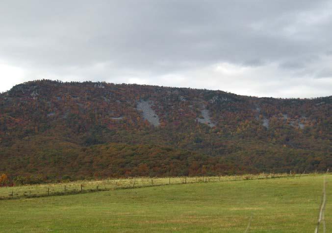
3 General Page County Stats Massanutten Mtns Elevation: Max: 4032 ft Min: ft Slope: Maximum: 85.6 Mean: 12.6 SD: 9.4 Size of County: 314 mi 2 Population: 24,042 * No known or recorded modern landslides before completion of the project *
4 Bedrock Geology (Southworth et al, 2009) Valley and Ridge General Page County Stats Elevation: Max: 4032 ft Min: ft Slope: Maximum: 85.6 Mean: 12.6 SD: 9.4 Size of County: 314 mi 2 Blue Ridge Population: 24,042 * No known or recorded modern landslides before completion of the project *

5 500 Landslides Precip: 15 in/24 hrs 584 Landslides Precip: 30 in/14 hrs Landslides Precip: 27 in/8 hrs
 Show areas susceptible to rapid LS initiation during heavy rainfall Will focus on critical facilities and infrastructure")
6 1. Slope Movement/Slope Movement Deposits Map and Inventory 2. Landslide Susceptibility Modeling and Map(s) Show areas susceptible to rapid LS initiation during heavy rainfall Will focus on critical facilities and infrastructure Help guide informed development and emergency management decisions *Completion Date of August 31, 2013*

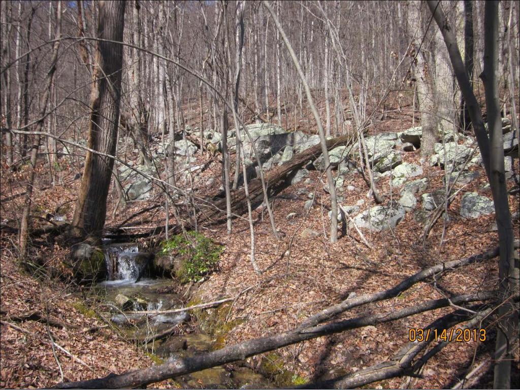
7 File Geodatabase: Processes (Landslide Points) Deposits (Ancient landslide polygons) Landslide Tracks Air Photo Points Field Notes Related Tables Rock/Soil/Geologic Data
8 Total # LS in Database as of 7/18/2013: 4817 LS Type: Debris Flow/Slide Mean Slope at Headscarp: 27


9 Type: Weathered Rx Slides; Debris Flows; Debris Slides Slope: Min 15 Max 80 *Mean - 32 All on natural slopes 7 of 9 occurred in Blue Ridge 6 initiated at the base of geologic contacts 1 2
10 Phase I: Field Work Preparation Aerial Photography Interpretation DTM LS Deposit Interpretation Phase II: Field Reconnaissance Adjust Interpreted Data Phase III: Slope Stability Modeling SINMAP Where landslides may start Phase IV: Hydrologic Flow Routing Debris Flow Pathways Where landslides may go Phase V: Finalize GIS Map Deliverables

11 Aerial Photography Interpretation 60 Potential landslides identified for further field investigation 42 visited; 4 were landslides Interpretation done at 1:6,000 Air Photo Vintages: 1958, , 1972, 1998, 2002, 2006, 2011 Air Photo Point 1998 Infrared DOQQ


12 Air Photo Point Air Photo Point Process Points 1998 Infrared DOQQ 2011 Infrared DOQQ
13
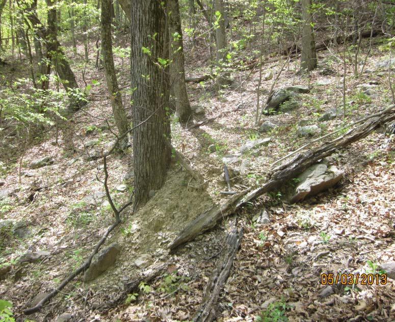
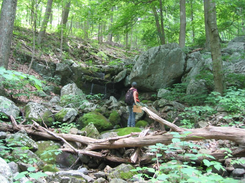
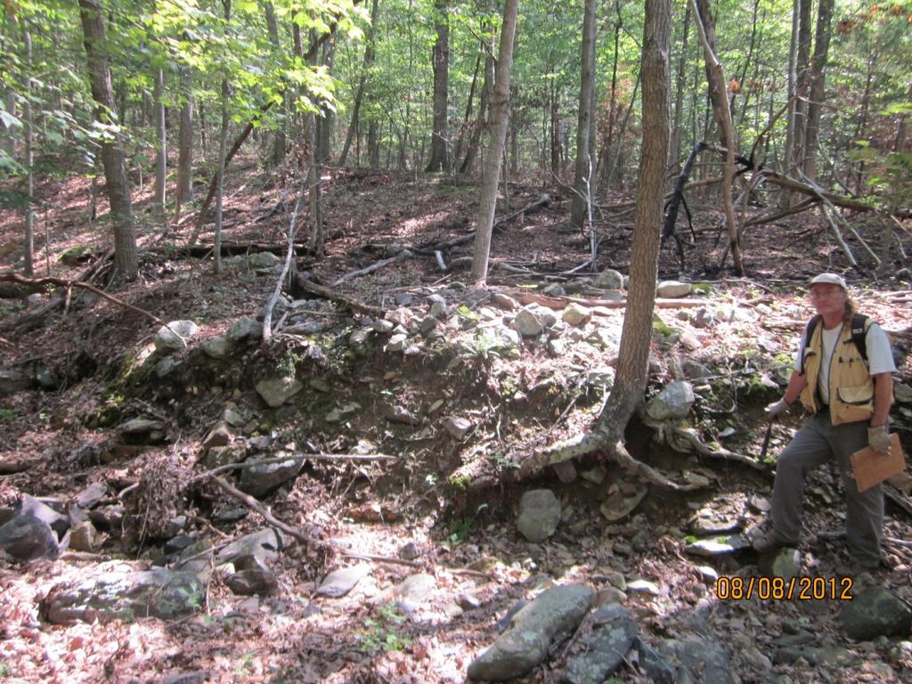
")
 Blue Ridge : Harpers")

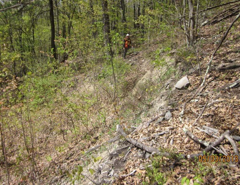
14 Air Photo Point 2006 DOQQ Massanutten: Martinsburg shale (Om) Devonian/Silurian shale, mudstone, siltstone (DSu) Blue Ridge : Harpers Fm phyllite (Cch) Looking downhill from interpreted headscarp in the Martinsburg shale (Om)

15 Landslide Deposit Interpretation Identified using DTM data (10 ft resolution), 5 ft contours and aerial photography Interpretation done at 1:6, Polygons in Database Mostly ancient debris fan deposits accumulations of coarse boulder-to-sand sized colluvial particles


16 Identified using ONLY aerial photography Must be able to see patches of bare rock at 1:6,000 Primarily a maintenance/construction hazard 2011 Infrared DOQQ


17 Identified using a combination of aerial photography and DTM Some are highly dissected by modern stream channels Moderate hazard if remobilized


18 Identified ONLY using DTM and contours Accumulations of subangular -tosubrounded boulder-tocobble size fragments in a finer-grained matrix Upper reaches may include boulder streams/talus Considered moderate hazard DTM with slope overlay; Index Contour = 100ft
 of rounded")


19 Massanutten Thin veneer (~1 ft) of rounded quartzite cobbles-to-boulders Red/brown soils with ghost clasts Higher clay % than younger deposits


20 Massanutten Rounded quartzite cobblesto-boulders (where visible) Flatter topography Sometimes perched on higher hilltops


21 Blue Ridge Rounded cobbles-to boulders of various lithologies in a chaotic matrix Little surface expression Soil rubification

22 Field Reconnaissance Basic Field Work Stats Hike Miles Traversed: 154 mi Road Miles Traversed: 110 mi # Field Notes collected DGMR: 1408 # Field Notes collected JMU: 292


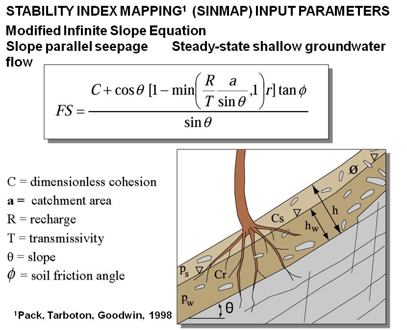
23 SINMAP (Stability Index MAPping)1 GIS model that shows where debris flows may start Based on modified infinite slope stability equation > 5 inches of rainfall in 24 hours only for unmodified or natural slopes (1Pack et al., 1998)
 Root Cohesion (C r ) Soil Hydraulic Conductivity (K sat )")
 Manual; Hammond et")
24 Upper and Lower Bounding Parameter Values: Soil Friction Angle (φ) Soil Cohesion (C s ) Root Cohesion (C r ) Soil Hydraulic Conductivity (K sat ) Parameters Derived from: Soil Testing (9 field sites) USDA-NRCS Soil Mapping County Water Well Logs Level I Stability Analysis (LISA) Manual; Hammond et al., 1992

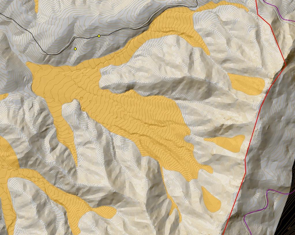
25 Stability Index Map Zones and Rankings


26 County-wide Relative Hazard High: 11.2% Unstable Upper Threshold Moderate: 13.9% Low: 78.8% Lower Threshold Nominally Stable Moderately Stable Stable All landslides fall into medium or high relative hazard areas

27 Debris Flow Pathways Hydrologic flow paths generated from high hazard SINMAP zones using the DEM Flow paths buffered to 65 ft (20 m) wide Flow paths terminated: Methodology At slopes of 3 degrees in areas > 0.25 acres When they encounter the 500-year floodplain When they encounter mapped impoundments >0.25 acres At bases of cut slopes SINMAP Debris Flow Pathways Mapped debris flow pathways Potential debris flow pathways Past debris flow activity (deposits) No known past or potential debris flow activity
28 Mapped debris flow pathways increasing Potential debris flow pathways (from SINMAP) Past debris flow activity (deposits) No known past or potential debris flow activity Relative Hazard decreasing Debris Flow Pathways Map


29 Complete LS Hazard Modeling Final Delivery to Page County Summer 2013 Field Review Fall 2013 Debris Flow Volumetric Analysis JMU Research Debris Flow Pathways


30 Grant Support: FEMA VDEM From JMU: Dr. Scott Eaton Billy Cheung Steve Stone From UNCW: Dr. Michael Smith Anne Carter Witt VA Division of Geology and Mineral Resources
31

32 DTM with slope overlay
33


34 Field Reconnaissance Basic Field Work Stats Hike Miles Traversed: 154 mi Road Miles Traversed: 110 mi # Field Notes collected DGMR: 1408 # Field Notes collected JMU: 292
35
Monitoring and Characterization of the Meadowview Lane Landslide: Boyd County, KY
 Monitoring and Characterization of the Meadowview Lane Landslide: Boyd County, KY Matt Crawford Appalachian Coalition for Geologic Hazards in Transportation 13 th Annual Technical Forum Harrisonburg, VA
Dan Miller + Kelly Burnett, Kelly Christiansen, Sharon Clarke, Lee Benda. GOAL Predict Channel Characteristics in Space and Time
 Broad-Scale Models Dan Miller + Kelly Burnett, Kelly Christiansen, Sharon Clarke, Lee Benda GOAL Predict Channel Characteristics in Space and Time Assess Potential for Fish Use and Productivity Assess
Landslide Computer Modeling Potential
 Landslide Computer Modeling Potential Michael D. Dixon, P.E. Civil Engineer Payette National Forest The Payette National Forest selected the Stability Index Mapping (SINMAP) model for use in identifying
Interpretive Map Series 24
 Oregon Department of Geology and Mineral Industries Interpretive Map Series 24 Geologic Hazards, and Hazard Maps, and Future Damage Estimates for Six Counties in the Mid/Southern Willamette Valley Including
Sediment and sedimentary rocks Sediment
 Sediment and sedimentary rocks Sediment From sediments to sedimentary rocks (transportation, deposition, preservation and lithification) Types of sedimentary rocks (clastic, chemical and organic) Sedimentary
Natural hazards in Glenorchy Summary Report May 2010
 Natural hazards in Glenorchy Summary Report May 2010 Contents Glenorchy s hazardscape Environment setting Flood hazard Earthquakes and seismic hazards Hazards Mass movement Summary Glossary Introduction
August 31, 2006 Embankment Failure Debris Flow at the Cascades Development Haywood County, North Carolina. Introduction. Findings
 August 31, 2006 Embankment Failure Debris Flow at the Cascades Development Haywood County, North Carolina Introduction North Carolina Geological Survey (NCGS) staff members visited the site of the August
=%REPORT RECONNAISSANCE OF CHISHOLM LAKE PROSPECT. October 25, 1977
 =%REPORT ON FIELD RECONNAISSANCE OF CHISHOLM LAKE PROSPECT October 25, 1977 Bruce D. Vincent Imperial Oil Limited, Minerals - Coal, CALGARY, ALBERTA CHISHOLM LAKE PROSPECT Introduction The Chisholm Lake
THE NEW DNR LANDSLIDE HAZARDS PROGRAM
 THE NEW DNR LANDSLIDE HAZARDS PROGRAM Kara Jacobacci, G.I.T. Landslide Hazards Program Washington Geological Survey Washington Department of Natural Resources LEGISLATIVE FUNDING 2015 session DNR requested
Soil Map Boulder County Area, Colorado (Planet Blue Grass) Web Soil Survey National Cooperative Soil Survey
 Web Soil Survey National Cooperative Soil Survey") 475910 476000 476090 476180 476270 476360 105 16' 21'' W 476450 476540 476630 476720 476810 4453350 4453440 4453260 4453350 4453170 4453260 4453080 4453170 4453080 475820 475910 4452990 476000 476090 476180
475910 476000 476090 476180 476270 476360 105 16' 21'' W 476450 476540 476630 476720 476810 4453350 4453440 4453260 4453350 4453170 4453260 4453080 4453170 4453080 475820 475910 4452990 476000 476090 476180
Date of Report: EPA agreement number: Center Name and Institution of Ctr. Director: Identifier used by Center for Project: Title of Project:
 Date of Report: March 31, 2003 EPA agreement number: R829515C003 Center Name and Institution of Ctr. Director: Rocky Mountain Regional Hazardous Substance Research Center, Colorado State University, Fort
Practical reliability approach to urban slope stability
 University of Wollongong Research Online Faculty of Engineering - Papers (Archive) Faculty of Engineering and Information Sciences 2011 Practical reliability approach to urban slope stability R. Chowdhury
J.H. Campbell Generating Facility Pond A - Location Restriction Certification Report
 J.H. Campbell Generating Facility Pond A - Location Restriction Certification Report Pursuant to: 40 CFR 257.60 40 CFR 257.61 40 CFR 257.62 40 CFR 257.63 40 CFR 257.64 Submitted to: Consumers Energy Company
2014 Summer Training Courses on Slope Land Disaster Reduction Hydrotech Research Institute, National Taiwan University, Taiwan August 04-15, 2014
 Final Project Report 2014 Summer Training Courses on Slope Land Disaster Reduction Hydrotech Research Institute, National Taiwan University, Taiwan August 04-15, 2014 Landslides in Mt. Umyeon Susceptibility
Geo-hazard Potential Mapping Using GIS and Artificial Intelligence
 Geo-hazard Potential Mapping Using GIS and Artificial Intelligence Theoretical Background and Uses Case from Namibia Andreas Knobloch 1, Dr Andreas Barth 1, Ellen Dickmayer 1, Israel Hasheela 2, Andreas
Big Rivers Electric Corporation Disposal of Coal Combustion Residuals (CCR) from Electric Utilities Final Rule CCR Impoundment Liner Assessment Report
 from Electric Utilities Final Rule CCR Impoundment Liner Assessment Report") Big Rivers Electric Corporation Disposal of Coal Combustion Residuals (CCR) from Electric Utilities Final Rule CCR Impoundment Liner Assessment Report CCR Surface Impoundment Information Name: Operator:
Big Rivers Electric Corporation Disposal of Coal Combustion Residuals (CCR) from Electric Utilities Final Rule CCR Impoundment Liner Assessment Report CCR Surface Impoundment Information Name: Operator:
Gateway Trail Project
 Gateway Trail Project Debris Flow Hazard Assessment By: Juan de la Fuente April 30, 2010 Background- On April 22, 2010, the Shasta-Trinity National Forest (Mt. Shasta-McCloud Unit) requested a geologic
Response on Interactive comment by Anonymous Referee #1
 Response on Interactive comment by Anonymous Referee #1 Sajid Ali First, we would like to thank you for evaluation and highlighting the deficiencies in the manuscript. It is indeed valuable addition and
Eagle Creek Post Fire Erosion Hazard Analysis Using the WEPP Model. John Rogers & Lauren McKinney
 Eagle Creek Post Fire Erosion Hazard Analysis Using the WEPP Model John Rogers & Lauren McKinney Columbia River Gorge at Risk: Using LiDAR and GIS-based predictive modeling for regional-scale erosion susceptibility
SLOPE FAILURE SLOPES. Landslides, Mudflows, Earthflows, and other Mass Wasting Processes
 GEOL g406 Environmental Geology SLOPE FAILURE Landslides, Mudflows, Earthflows, and other Mass Wasting Processes Read Chapter 5 in your textbook (Keller, 2000) Gros Ventre landslide, Wyoming S. Hughes,
Introduction. Inventory Mapping and Characterization of Landslides Using LiDAR
 Introduction Landslide identification and hazard mapping using light detection and ranging (LiDAR) have proven successful in Kentucky and other landslide prone areas of the United States, such as Oregon,
INTRODUCTION. Climate
 INTRODUCTION Climate Landslides are serious natural disasters in many parts of the world. Since the past 30 years, rainfall triggered landslides and debris flows had been one of the natural disasters of
Flood Inundation Mapping
 KU GIS Day 2009 November 18, 2009 Flood Inundation Mapping Wendy L. Pearson NOAA s National Weather Service Central Region Headquarters Kansas City, Missouri Flood Inundation Mapping Objectives: Overview
Understanding Earth Fifth Edition
 Understanding Earth Fifth Edition Grotzinger Jordan Press Siever Chapter 16: WEATHERING, EROSION, AND MASS WASTING Interface Between Climate and Tectonics Lecturer: H Mohammadzadeh Assistant professors,
Pierce Cedar Creek Institute GIS Development Final Report. Grand Valley State University
 Pierce Cedar Creek Institute GIS Development Final Report Grand Valley State University Major Goals of Project The two primary goals of the project were to provide Matt VanPortfliet, GVSU student, the
Sediments and. Sedimentary Rocks
 Sediments and Sedimentary Rocks Bottom Line Sedimentary rocks form from particles accumulated in sedimentary layers Sedimentary layers can be formed by clastic or detrital particles (e.g., sand grains,
Hydraulic Impacts of Limestone Quarries and Gravel Pits. Jeff Green Minnesota DNR-Division of Ecological & Water Resources
 Hydraulic Impacts of Limestone Quarries and Gravel Pits Jeff Green Minnesota DNR-Division of Ecological & Water Resources The Hydraulic Impacts of Limestone Quarries and Gravel Pits Study was funded by
Soil Surveys. What are the most important properties to consider in a taxonomic system used for making a soil survey?
 Soil Surveys What are the most important properties to consider in a taxonomic system used for making a soil survey? What is a Soil Survey? Inventory of soil resources Delineation of spatial distribution
Geology and New England Landscapes
 Geology and New England Landscapes Jim Turenne, CPSS USDA-NRCS Warwick, RI. http://nesoil.com Why Geology? Provides the big picture of site conditions. Major part of soil formation (parent material and
Vermont Stream Geomorphic Assessment. Appendix E. River Corridor Delineation Process. VT Agency of Natural Resources. April, E0 - April, 2004
 Vermont Stream Geomorphic Assessment Appendix E River Corridor Delineation Process Vermont Agency of Natural Resources - E0 - River Corridor Delineation Process Purpose A stream and river corridor delineation
Using Weather and Climate Information for Landslide Prevention and Mitigation
 Using Weather and Climate Information for Landslide Prevention and Mitigation Professor Roy C. Sidle Disaster Prevention Research Institute Kyoto University, Japan International Workshop on Climate and
Urban Erosion Potential Risk Mapping with GIS
 Urban Erosion Potential Risk Mapping with GIS ESRI Water Conference San Diego, CA Jan 29-Feb 1, 2018 Dr. Randy Dymond, PE, F.ASCE, D.WRE Co-investigators: Amanda Weikmann, MS Student Dr. Clay Hodges, PE
Landslides & Debris Flows
 T.#Perron# #12.001# #Landslides#&#Debris#Flows# 1# Landslides & Debris Flows Many geologic processes, including those shaping the land surface, are slowacting, involving feedbacks that operate over many
A Roundup of Recent Debris Flow Events in Taiwan
 2015 International Workshop on Typhoon and Flood APEC Experience Sharing on Hazardous Weather Events and Risk Management A Roundup of Recent Debris Flow Events in Taiwan Hsiao-Yuan(Samuel) Yin Ph.D. sammya@mail.swcb.gov.tw
Landscapes Prone to Rockfall, Rockslides, Debris Avalanches, Flows, and Torrents
 1) Landform Regional landscape Landscapes are qualitative indicators of unstable terrain that may be obtained from air photos, topographic maps, and limited field reconnaissance. Landscapes Prone to Rockfall,
American Institute of Professional Geologists South Dakota Section
 American Institute of Professional Geologists South Dakota Section 2015 Field Trip Guide Deadwood Formation in the Black Hills of South Dakota and Frac Sand Potential Saturday, September 12, 2015 1 Field
Module 10: Resources and Virginia Geology Topic 4 Content: Virginia Geology Notes
 Virginia is composed of a very diverse landscape that extends from the beaches and barrier islands all of the way to the highly elevated Appalachian Plateau. Geologists have discovered ancient shallow
Debris flow: categories, characteristics, hazard assessment, mitigation measures. Hariklia D. SKILODIMOU, George D. BATHRELLOS
 Debris flow: categories, characteristics, hazard assessment, mitigation measures Hariklia D. SKILODIMOU, George D. BATHRELLOS Natural hazards: physical phenomena, active in geological time capable of producing
Geology 101. Reading Guides for Chapters 5 and 14 Weathering: the Breakdown of Rocks (p. 142)
") Geology 101 Name Reading Guides for Chapters 5 and 14 Weathering: the Breakdown of Rocks (p. 142) Please read the introduction to the chapter. What is the difference between weathering and erosion? Weathering
Geology 101 Name Reading Guides for Chapters 5 and 14 Weathering: the Breakdown of Rocks (p. 142) Please read the introduction to the chapter. What is the difference between weathering and erosion? Weathering
Geospatial Approach for Delineation of Landslide Susceptible Areas in Karnaprayag, Chamoli district, Uttrakhand, India
 Geospatial Approach for Delineation of Landslide Susceptible Areas in Karnaprayag, Chamoli district, Uttrakhand, India Ajay Kumar Sharma & Anand Mohan Singh Overview Landslide - movement of a mass of rock,
MINISTRY OF FORESTS, LANDS AND NATURAL RESOURCE OPERATIONS, POST-WILDFIRE RISK ANALYSIS PRELIMINARY REPORT
 MINISTRY OF FORESTS, ANDS AND NATURA RESOURCE OPERATIONS, POST-WIDFIRE RISK ANAYSIS PREIMINARY REPORT NOTE: The results given on this form are preliminary in nature and are intended to be a warning of
Evaluation of Landslide Hazard Assessment Models at Regional Scale (SciNet NatHazPrev Project)
") Evaluation of Landslide Hazard Assessment Models at Regional Scale (SciNet NatHazPrev Project) Democritus University of Thrace (P1) Department of Civil Engineering Geotechnical Division Scientific Staff:
Evaluation of Landslide Hazard Assessment Models at Regional Scale (SciNet NatHazPrev Project) Democritus University of Thrace (P1) Department of Civil Engineering Geotechnical Division Scientific Staff:
ASFPM - Rapid Floodplain Mapping
 ASFPM - Nicole Cominoli Hydraulic Engineer USACE - Omaha District mary.n.cominoli@usace.army.mil June 3, 2015 US Army Corps of Engineers Mitigation = Risk Informed Decisions 2 The National Flood Insurance
Mass Wasting. Revisit: Erosion, Transportation, and Deposition
 Mass Wasting Revisit: Erosion, Transportation, and Deposition While landslides are a normal part of erosion and surface processes, they can be very destructive to life and property! - Mass wasting: downslope
Page 1. Name:
 Name: 1) Which event is the best example of erosion? dissolving of rock particles on a limestone gravestone by acid rain breaking apart of shale as a result of water freezing in a crack rolling of a pebble
June 9, R. D. Cook, P.Eng. Soils Engineer Special Services Western Region PUBLIC WORKS CANADA WESTERN REGION REPORT ON
 PUBLIC WORKS CANADA WESTERN REGION REPORT ON GEOTECHNICAL INVESTIGATION PROPOSED MARTIN RIVER BRIDGE MILE 306.7 MACKENZIE HIGHWAY Submitted by : R. D. Cook, P.Eng. Soils Engineer Special Services Western
Sediment and Sedimentary rock
 Sediment and Sedimentary rock Sediment: An accumulation of loose mineral grains, such as boulders, pebbles, sand, silt or mud, which are not cemented together. Mechanical and chemical weathering produces
ESRI GIS For Mining Seminar, 10 th August, 2016, Nairobi, Kenya. Spatial DATA Solutions for Mining
 ESRI GIS For Mining Seminar, 10 th August, 2016, Nairobi, Kenya Spatial DATA Solutions for Mining Spatial Data Solutions for Mining Spatial - Data that identifies the geographic location of features &
INFLOW DESIGN FLOOD CONTROL SYSTEM PLAN 40 C.F.R. PART PLANT YATES ASH POND 2 (AP-2) GEORGIA POWER COMPANY
 GEORGIA POWER COMPANY") INFLOW DESIGN FLOOD CONTROL SYSTEM PLAN 40 C.F.R. PART 257.82 PLANT YATES ASH POND 2 (AP-2) GEORGIA POWER COMPANY EPA s Disposal of Coal Combustion Residuals from Electric Utilities Final Rule (40 C.F.R.
INFLOW DESIGN FLOOD CONTROL SYSTEM PLAN 40 C.F.R. PART 257.82 PLANT YATES ASH POND 2 (AP-2) GEORGIA POWER COMPANY EPA s Disposal of Coal Combustion Residuals from Electric Utilities Final Rule (40 C.F.R.
Rogun Hydropower Project
 Rogun Hydropower Project Dam site Geological investigations in the Downstream Right Bank Ascencio Lara Coyne et Bellier Almaty, 11-12 February 2013 Objectives of the presentation As the stability conditions
APPALACHIAN COLLUVIAL
 LANDSLIDE PROBLEMS ON APPALACHIAN COLLUVIAL SLOPES Geohazards in Transportation in the Appalachian Region Charleston, WV August 5 7, 2008 RICHARD E. GRAY DIGIOIA, GRAY & ASSOCIATES, LLC. 570 BEATTY ROAD
Geo 327G Semester Project. Landslide Suitability Assessment of Olympic National Park, WA. Fall Shane Lewis
 Geo 327G Semester Project Landslide Suitability Assessment of Olympic National Park, WA Fall 2011 Shane Lewis 1 I. Problem Landslides cause millions of dollars of damage nationally every year, and are
Figure 1 The map shows the top view of a meandering stream as it enters a lake. At which points along the stream are erosion and deposition dominant?
 1. In which type of climate does chemical weathering usually occur most rapidly? 1. hot and dry 3. cold and dry 2. hot and wet 4. cold and wet 2. Figure 1 The map shows the top view of a meandering stream
Which landscape best represents the shape of the valleys occupied by glaciers? A) B) C) D)
 B) C) D)") 1. Glaciers often form parallel scratches and grooves in bedrock because glaciers A) deposit sediment in unsorted piles B) deposit rounded sand in V-shaped valleys C) continually melt and refreeze D) drag
1. Glaciers often form parallel scratches and grooves in bedrock because glaciers A) deposit sediment in unsorted piles B) deposit rounded sand in V-shaped valleys C) continually melt and refreeze D) drag
Starting at Rock Bottom
 Starting at Rock Bottom At rock bottom of the Brushy Creek site s geological column lies the first clue to human habitation: A smelting and heattreating furnace, and mold, carved into Bed Ked: Figure 15
Dealing with Zone A Flood Zones. Topics of Discussion. What is a Zone A Floodplain?
 Dealing with Zone A Flood Zones Topics of Discussion Overview of Zone A Floodplains Permitting Development in Zone A Floodplains Estimating Flood Elevations in Zone A Flood Insurance Implications Letters
Chapter 7 Mudflow Analysis
 Chapter 7 Mudflow Analysis 7.0 Introduction This chapter provides information on the potential and magnitude of mud floods and mudflows that may develop in Aspen due to rainfall events, snowmelt, or rain
Maggie Payne Jim Turenne
 Maggie Payne Jim Turenne USDA-NRCS 60 Quaker Lane, Suite 46 Warwick, RI. 02886 401-822-8832 maggie.payne@ri.usda.gov U.S. Department of Agriculture 1935: Soil Conservation Service (SCS) Natural Resources
The Effects of Hydraulic Structures on Streams Prone to Bank Erosion in an Intense Flood Event: A Case Study from Eastern Hokkaido
 Symposium Proceedings of the INTERPRAENENT 2018 in the Pacific Rim The Effects of Hydraulic Structures on Streams Prone to Bank Erosion in an Intense Flood Event: A Case Study from Eastern Hokkaido Daisuke
CHAPTER GEOLOGICALLY HAZARDOUS AREAS Applicability Regulations.
 CHAPTER 19.07 GEOLOGICALLY HAZARDOUS AREAS 19.07.010 Applicability. Geologically hazardous areas may pose a threat to the health and safety of citizens when incompatible development is sited in areas of
Chapter 16 Weathering, Erosion, Mass Wasting. Chapter 16 Weathering, Erosion, Mass Wasting. Mechanical Weathering
 Weathering, Erosion and Mass Wasting Weathering is the the breakdown of solid rock at or near the Earth's surface. Chapter 16 Weathering, Erosion, Mass Wasting Does weathering of rock remove or add CO
Watershed concepts for community environmental planning
 Purpose and Objectives Watershed concepts for community environmental planning Dale Bruns, Wilkes University USDA Rural GIS Consortium May 2007 Provide background on basic concepts in watershed, stream,
3.12 Geology and Topography Affected Environment
 3 Affected Environment and Environmental Consequences 3.12 Geology and Topography 3.12.1 Affected Environment 3.12.1.1 Earthquakes Sterling Highway MP 45 60 Project Draft SEIS The Kenai Peninsula is predisposed
Appendix C. Questionnaire Summary of Responses Geographic Information Systems
 Appendix C Questionnaire Summary of Responses Geographic Information Systems 1. Is your agency using or planning use of GIS for: a. general mapping (e.g. highway routes, political boundaries, etc.) b.
Assessment of regional rainfall-induced landslides using 3S-based hydro-geological model
 Landslides and Engineered Slopes Chen et al. (eds) 2008 Taylor & Francis Group, London, ISBN 978-0-415-41196-7 Assessment of regional rainfall-induced landslides using 3S-based hydro-geological model C.H.
ENGRG Introduction to GIS
 ENGRG 59910 Introduction to GIS Michael Piasecki March 17, 2014 Lecture 08: Terrain Analysis Outline: Terrain Analysis Earth Surface Representation Contour TIN Mass Points Digital Elevation Models Slope
EROSION AND DEPOSITION
 CHAPTER 8 EROSION AND DEPOSITION SECTION 8 1 Changing Earth s Surface (pages 252-255) This section explains how sediment is carried away and deposited elsewhere to wear down and build up Earth s surface.
New Topic Today. Mass Movement = Mass Wasting. =colluvial processes =slope processes =slope failures =LANDSLIDES. Landslides by U.S.
 New Topic Today Mass Movement = Mass Wasting =colluvial processes =slope processes =slope failures =LANDSLIDES U.S. Landslide Risk Which states have lots of landslide damage? Landslides by U.S. Region
KANSAS GEOLOGICAL SURVEY Open File Report LAND SUBSIDENCE KIOWA COUNTY, KANSAS. May 2, 2007
 KANSAS GEOLOGICAL SURVEY Open File Report 2007-22 LAND SUBSIDENCE KIOWA COUNTY, KANSAS Prepared by Michael T. Dealy L.G., Manager, Wichita Operations SITE LOCATION The site was approximately four miles
Existing NWS Flash Flood Guidance
 Introduction The Flash Flood Potential Index (FFPI) incorporates physiographic characteristics of an individual drainage basin to determine its hydrologic response. In flash flood situations, the hydrologic
Climatic Change Implications for Hydrologic Systems in the Sierra Nevada
 Climatic Change Implications for Hydrologic Systems in the Sierra Nevada Part Two: The HSPF Model: Basis For Watershed Yield Calculator Part two presents an an overview of why the hydrologic yield calculator
July 21, 2018
 www.eastforklewisriver.org: July 21, 2018 A Non-Profit (501C3) Tax Deductible Group, Dedicated to Advocacy of Good Land & Water Stewardship BRIEFING REPORT ON HYDROLOGIC-GEOMORPHIC CHARACTERISTICS OF THE
ENGINEERING GEOLOGY. Landslides by U.S. Region. WV Has 1st or 2nd Highest Landslide Damage Per Capita $ /person/yr UTAH
 Essay Questions for 2007 http://www.geo.wvu.edu/~kite/2007test1ques321.html New Topic: SLOPES Colluvial - Related to Hill-Slope or Mountain-Slope Processes, Especially Those Driven Directly by Gravity
Objectives. Introduction to Soils. Terms to know: What is soil? Study of Soils. The Soil Body 11/9/2012
 Objectives Explain what soil is and where it comes from Define a soil body List examples of the five soil-forming factors Explain how soils develop Introduction to Soils Terms to know: What is soil? Alluvial
Clyde River Landslide
 Clyde River Landslide Department of Geology, Perkins Hall, University of Vermont, Burlington, VT 05405 Abstract: This paper investigates a landslide on the Clyde River in Newport, Vermont. The landslide
HILLSLOPE STABILITY. Focus in the Westfork Area of Washington County, Arkansas. Environmental Geology Dr. Paul Lowrey
 Environmental Geology Dr. Paul Lowrey Team Members Christine Gossett Jennifer Lane Lauren Morrison Nicole Sage Focus in the Westfork Area of Washington County, Arkansas HILLSLOPE STABILITY INTRODUCTION
Technical Memorandum. To: From: Copies: Date: 10/19/2017. Subject: Project No.: Greg Laird, Courtney Moore. Kevin Pilgrim and Travis Stroth
 Technical Memorandum To: From: Greg Laird, Courtney Moore Kevin Pilgrim and Travis Stroth 5777 Central Avenue Suite 228 Boulder, CO 80301 www.otak.com Copies: [Electronic submittal] Date: 10/19/2017 Subject:
Geology 101. Reading Guides for Chapters 6 and 12
 Geology 101 Name Chapter 6: Weathering and Soils (p. 160): Reading Guides for Chapters 6 and 12 This chapter is about the processes involved in the disintegration of rock. Weathering is often mistaken
Jim Turenne. Soils on Social Media
 Jim Turenne USDA-NRCS 60 Quaker Lane, Suite 46 Warwick, RI. 02886 401-822-8832 Jim.turenne@ri.usda.gov Soils on Social Media www.twitter.com/soilsne www.fb.com/soilsne www.nesoil.com U.S. Department of
SECTION G SEDIMENT BUDGET
 SECTION G SEDIMENT BUDGET INTRODUCTION A sediment budget has been constructed for the for the time period 1952-2000. The purpose of the sediment budget is to determine the relative importance of different
NATURAL SOIL DEPOSITS
 NATURAL SOIL DEPOSITS Soils are produced by weathering of rock. Weathering is the physical or chemical breakdown of rock. Physical Processes: - Unloading - Frost Action - Organism Growth - Crystal Growth
ENGINEERING EVALUATION OF THE STANLEY MINE ADVENTURE PARK AREA CLEAR CREEK COUNTY, COLORADO. Prepared for:
 braun Braun Consulting Engineers ENGINEERING EVALUATION OF THE STANLEY MINE ADVENTURE PARK AREA CLEAR CREEK COUNTY, COLORADO Prepared for: STANLEY MINES ADENTURE PARK 3375 W. POWERS CIRCLE LITTLETON, COLORADO
UPPER COSUMNES RIVER FLOOD MAPPING
 UPPER COSUMNES RIVER FLOOD MAPPING DRAFT BASIC DATA NARRATIVE FLOOD INSURANCE STUDY SACRAMENTO COUTY, CALIFORNIA Community No. 060262 November 2008 Prepared By: CIVIL ENGINEERING SOLUTIONS, INC. 1325 Howe
International Journal of Modern Trends in Engineering and Research e-issn No.: , Date: April, 2016
 International Journal of Modern Trends in Engineering and Research www.ijmter.com e-issn No.:2349-9745, Date: 28-30 April, 2016 Landslide Hazard Management Maps for Settlements in Yelwandi River Basin,
Using LiDAR to Map Landslides in Kenton and Campbell Counties, Kentucky. Matthew M. Crawford
 Kentucky Geological Survey James C. Cobb, State Geologist and Director University of Kentucky, Lexington Using LiDAR to Map Landslides in Kenton and Campbell Counties, Kentucky Matthew M. Crawford Report
Roger Andy Gaines, Research Civil Engineer, PhD, P.E.
 Roger Andy Gaines, Research Civil Engineer, PhD, P.E. Research Civil Engineer/Regional Technical Specialist Memphis District August 24, 2010 Objectives Where we have been (recap of situation and what s
Exhibit RMP-4. Foote Creek Geology and Topography
 Exhibit RMP-4 Foote Creek Geology and Topography Memorandum To: From: CC: Travis Brown, PacifiCorp Daria Drago, P.E., PMP Dr. Deb Luchsinger Date: January 9, 2019 Re: Foote Creek Rim 1 - Geologic Conditions
GEOL.3250 Geology for Engineers Glacial Geology
 GEOL.3250 Geology for Engineers Glacial Geology NAME Part I: Continental Glaciation Continental glaciers are large ice sheets that cover substantial portions of the land area. In the region of accumulation
INTERV AL SHEET. VDMR Well No.: WELL NO. 699 WWCR #186. Oil Gas, Water_ X,Exp1oratory. From- To 300_ _ _ _
 ) Page,_-=-H~l,-- Date, 8~-~2~7_-~62=- PROP: PROP : BLUE RIDGE POULTRY AND EGG CXi. #2 COMP: COMP : SYDNOR COUNTY: SHENANDOAH COUNTY: (CDLUMB IA FURNACE) VDMR WELL NO. W699 FROM: TO : INTERV AL SHEET VDMR
1. The map below shows a meandering river. A A' is the location of a cross section. The arrows show the direction of the river flow.
 1. The map below shows a meandering river. A A' is the location of a cross section. The arrows show the direction of the river flow. Which cross section best represents the shape of the river bottom at
LOMR SUBMITTAL LOWER NEHALEM RIVER TILLAMOOK COUNTY, OREGON
 LOMR SUBMITTAL LOWER NEHALEM RIVER TILLAMOOK COUNTY, OREGON Prepared for: TILLAMOOK COUNTY DEPARTMENT OF COMMUNITY DEVELOPMENT 1510-B THIRD STREET TILLAMOOK, OR 97141 Prepared by: 10300 SW GREENBURG ROAD,
UPDATING THE LANDSLIDE HAZARD ASSESSMENT SYSTEM WITHIN THE CITY OF THE GOLD COAST
 UPDATING THE LANDSLIDE HAZARD ASSESSMENT SYSTEM WITHIN THE CITY OF THE GOLD COAST Patrick Kidd Geotechnical Manager, SMEC Australia, Gold Coast, Queensland, Australia ABSTRACT The City of Gold Coast has
Chapter 7 Mudflow Analysis
 Chapter 7 Mudflow Analysis 7.0 Introduction This chapter provides information on the potential and magnitude of mud floods and mudflows that may develop in Aspen due to rainfall events, snowmelt, or rain
Chapter 2. Regional Landscapes and the Hydrologic Cycle
 Chapter 2. Regional Landscapes and the Hydrologic Cycle W. Lee Daniels Department of Crop and Soil Environmental Sciences, Virginia Tech Table of Contents Introduction... 23 Soils and landscapes of the
NC Earth Science Essential Standards
 NC Earth Science Essential Standards EEn. 2.1 Explain how processes and forces affect the Lithosphere. EEn. 2.1.1 Explain how the rock cycle, plate tectonics, volcanoes, and earthquakes impact the Lithosphere.
GG101 Lecture 22: Mass Wasting. Soil, debris, sediment, and broken rock is called regolith.
 GG101 Lecture 22: Mass Wasting Mass Wasting is the movement of rock and soil down a slope due to the force of gravity. Soil, debris, sediment, and broken rock is called regolith. Mass wasting creates broad
STREUVER FIDELCO CAPPELLI, LLC YONKERS DOWNTOWN DEVELOPMENT PHASE 1. DRAFT ENVIRONMENTAL IMPACT STATEMENT For: PALISADES POINT
 STREUVER FIDELCO CAPPELLI, LLC YONKERS DOWNTOWN DEVELOPMENT PHASE 1 DRAFT ENVIRONMENTAL IMPACT STATEMENT For: PALISADES POINT Prepared by: PAULUS, SOKOLOWSKI & SARTOR STORMWATER MANAGEMENT 1. Methodology
A METHODOLOGY FOR ASSESSING EARTHQUAKE-INDUCED LANDSLIDE RISK. Agency for the Environmental Protection, ITALY (
 A METHODOLOGY FOR ASSESSING EARTHQUAKE-INDUCED LANDSLIDE RISK Roberto W. Romeo 1, Randall W. Jibson 2 & Antonio Pugliese 3 1 University of Urbino, ITALY (e-mail: rwromeo@uniurb.it) 2 U.S. Geological Survey
Springshed Springshed Management Training Curriculum
 Springshed Springshed Management Training Curriculum Management Training Curriculum Draft Version 2 January 2016 The Springs Initiative 2016 The Springs Initiative SESSION TITLE: Section Mapping SECTION:
The Importance of Mass Wasting
 Mass Wasting: The Work of Gravity Earth Chapter 15 Chapter 15 Mass Wasting The Importance of Mass Wasting Slopes are the most common elements in our physical landscape Slopes may appear to be stable, but