COASTAL VULNERABILITY DUE TO SEA-LEVEL RISE HAZARDS IN THE BANGLADESH DELTA: BAND-AID
|
|
|
- Kristopher Robbins
- 5 years ago
- Views:
Transcription


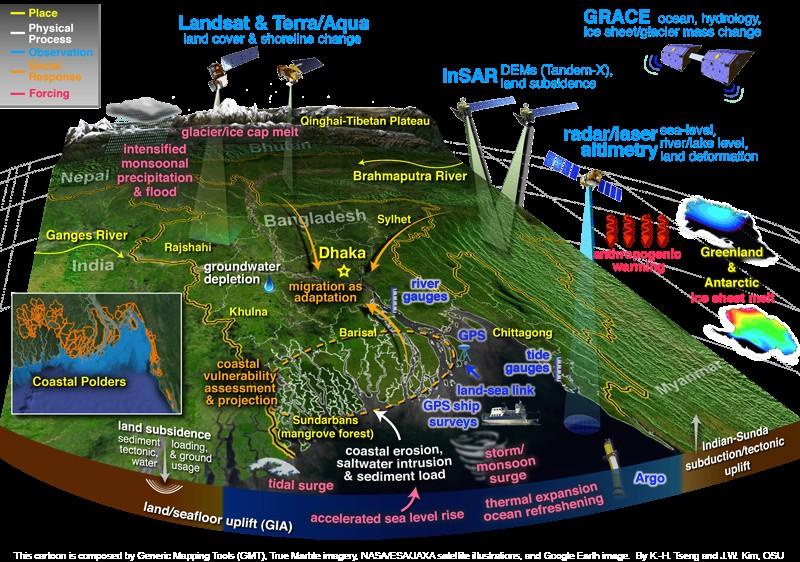
1 Band-Aid Project NASA NASA ESA ESA JAXA NASA/DLR COASTAL VULNERABILITY DUE TO SEA-LEVEL RISE HAZARDS IN THE BANGLADESH DELTA: BAND-AID R. Rietbroek, B. Uebbing, C.K. Shum, V. Ballu, S. Calmant, J. Duan, J. Guo, F. Hossain, C. Jenkins, Z. Haque Khan, J. Kim, M. Kuhn, J. Kusche, F. Papa, K-H Teng, J. Wan, B. Braun, A. Bernzen, R. Ahmed, and M. Hossain LIVELIHOOD RESILIENCE, RESEARCH, AND PRACTICE BONN, 26 JUNE, 2015 Partner: Bonn University, Germany Ohio State Univ., US IRD, France Inst. For Water Modelling, Dhaka, BD University of Cologne, Germany Curtin University, Perth, AUS LEGOS, Toulouse, France Univ. of Rajshai, Rajshahi, BD
2 Band-Aid Project BELMONT FORUM PROJECT: BANGLADESH COASTAL VULNERABILITY & SEA-LEVEL RISE HAZARDS, BAND-AID Ganges Brahmaputra-Meghna Delta (Bay of Bengal, Bangladesh) is the largest Delta and one of the most densely population regions in the world 2
3 Band-Aid Project BELMONT FORUM PROJECT: BANGLADESH COASTAL VULNERABILITY & SEA-LEVEL RISE HAZARDS, BAND-AID Ganges Brahmaputra-Meghna Delta (Bay of Bengal, Bangladesh) is the largest Delta and one of the most densely population regions in the world 3 Bangladesh is prone to transboundary monsoonal flooding, storm surges, and climate change induced sea-level rise. Land subsidence caused by tectonics, sediment load and ground water extraction have exacerbate the risks for Bangladesh s coastal vulnerability Objectives: (1) establish a satellite geodetic observational system to quantify sea-level rise and land motion in the Delta, and to project relative sea-level rise to 2100 and beyond, at fine regional scales, and (2) to quantify the human interaction and social sciences that govern coastal vulnerability in Bangladesh

4 20th century global mean sea level rise 4 Tide gauge trend ~ mm/year
5 Sea level rise is not uniform 5 Mean: 3mm/a
6 Sea level rise is not uniform 6 Mean: 3mm/a BoB: 6 mm/a
7 What are the issues adressed in Band-Aid 7 Bangladesh Assessment of SLR (~6 mm/y) and physical/social implications
8 What are the issues adressed in Band-Aid Himalaya and upstream Monsoonal changes 8 Sea level rise Floodings, surges and cyclones Salinization Tides and coastal morphology Vertical land motion Sedimentation Bangladesh Assessment of SLR (~6 mm/y) and physical/social implications Land use (agriculture, shrimp farming, reservoir construction) Tidal river management Coastal embankment strategies
9 Satellite-geodetic observational system 9

10 Climate variability and ocean heat uptake mm/a low-lying (<10m) Currently, sea level rise is accelerating along many coast of South Asia. A part of this is natural variability; i.e. it will not continue. But what part?
11 Sea level Projections Polders in green. Nonlinear (accelerated) sea-level projection based on climate scenarios [Parris et al. 2012; Vermeer & Rahmstorf, 2009] & reconstructed sea-level trend, [Meyssignac et al., 2012] & GPS subsidence [Steckler et al., 2012; courtesy]

12 Sea level Projections Polders in green. Nonlinear (accelerated) sea-level projection based on climate scenarios [Parris et al. 2012; Vermeer & Rahmstorf, 2009] & reconstructed sea-level trend, [Meyssignac et al., 2012] & GPS subsidence [Steckler et al., 2012; courtesy]

13 Sea level Projections
14 Relative sea level and its measurement Land subsidence is as important as sea level rise. Long-term monitoring (vertical control, tide gauge, geodetic network) very important!
15 Relative sea level and its measurement Bangladesh is a polder country, strong tides and morphology changes Long-term terrestrial monitoring along the coast is difficult and expensive. 15 Coastal embankment improvement project.

16 Relative sea level and its measurement Bangladesh is a polder country, strong tides and morphology changes Long-term terrestrial monitoring along the coast is difficult and expensive. Band-Aid: Integrate satellite data into terrestrial monitoring systems! 16 Coastal embankment improvement project.


17 Regional sea level rise 1st project meeting, Dhaka Tide gauge station installed by Band-Aid

 18")

18 Connecting satellite and tide gauge measurements S. Calmant (IRD) 18 Measuring sea level with a GPS float for calibrating satellite measurements
19 Band-Aid Project Sustainable Research Close cooperation with local partners (IWM, others Capacity building (e.g. training workshop 8/2015) Seek to engage in long-term collaboration 19
Global Population Density
 THE IMPORTANCE OF SCALE IN DEFINING VULNERABILITY OF THE GANGES-BRAHMAPUTRA RIVER DELTA TO ENVIRONMENTAL CHANGE Carol A. Wilson 1, Steven L. Goodbred, Jr. 1, Irina Overeem 2 1 Dept. of Earth and Environmental
EFFECTIVE TROPICAL CYCLONE WARNING IN BANGLADESH
 Country Report of Bangladesh On EFFECTIVE TROPICAL CYCLONE WARNING IN BANGLADESH Presented At JMA/WMO WORKSHOP ON EFFECTIVE TROPICAL CYCLONE WARNING IN SOUTHEAST ASIA Tokyo, Japan,11-14 March 2014 By Sayeed
Impact of Coastal Flooding on Land use Pattern Considering Climate Change
 Impact of Coastal Flooding on Land use Pattern Considering Climate Change Pronab Kumar Halder Institute of Water and Flood Management (IWFM), Bangladesh University of Engineering and Technology (BUET),pronab.halder@gmail.com
Vulnerability of Bangladesh to Cyclones in a Changing Climate
 Vulnerability of Bangladesh to Cyclones in a Changing Climate Susmita Dasgupta Kiran Pandey Mainul Huq Zahirul Huq Khan M.M. Zahid Ahmed Nandan Mukherjee Malik Fida Khan 2010 Bangladesh: Tropical Cyclone
Morphological Changes of the Offshore Islands of Western Part of Meghna Estuary over the Years
 Journal of Modern Science and Technology Vol. 6. No. 2. June 2018 Issue. Pp.0-0 Morphological Changes of the Offshore Islands of Western Part of Meghna Estuary over the Years Faisal Mohammad Alvee 1, Sayedul
Sedimentation Patterns in the Ganges- Brahmaputra Delta System
 Sedimentation Patterns in the Ganges- Brahmaputra Delta System SRTM-topography >10 m Irina Overeem, CSDMS, University of Colorado at Boulder K. Rogers, S. Goodbred, S. Higgins, K. Matin, Z. Kahn, S. Cohen,
UNIT 11 SOUTH ASIA SG 1 - PHYSICAL GEOGRAPHY & THE ENVIRONMENT
 UNIT 11 SOUTH ASIA SG 1 - PHYSICAL GEOGRAPHY & THE ENVIRONMENT I. PHYSICAL GEOGRAPHY TAKE OUT YOUR PHYSICAL MAP OF SOUTH ASIA A. The Himalayan Mountains form the northern boundary of the region (color
Regional and global trends
 SEA LEVEL RISE Regional and global trends OCEANOBS 2009 Plenary Paper A.Cazenave D. Chambers, P. Cipollini, J. Hurell, S. Nerem, L.L. Fu, H.P. Plag, C.K. Shum, J. Willis Venice, September 2009 Global mean
FIG Working Week May, Bulgaria From the wisdom of the ages to the challanges of modern world
 FIG Working Week 17-21 May, Bulgaria From the wisdom of the ages to the challanges of modern world COASTAL RISK ANALYSIS OF THE BLACK SEA UNDER THE SEA LEVEL RISE N e v i n B e t u l A V S A R, S e n o
Saiful Islam Anisul Haque
 Workshop on Disaster Prevention/Mitigation Measures against Floods and Storm Surges in Bangladesh on 17-21 November, 2012, in Kyoto University, Japan Component 2: Flood disaster risk assessment and mitigation
Impact of Climate Change on Riverbank Erosion
 International Journal of Sciences: Basic and Applied Research (IJSBAR) ISSN 2307-4531 http://gssrr.org/index.php?journal=journalofbasicandapplied Impact of Climate Change on Riverbank Erosion Most. Nazneen
COUNTRY PRESENTATION ON MR JAYNAL ABEDIN JOINT SECRETARY ( WORKS & DEVELOPMENT ) MINISTRY OF DEFENCE
 MINISTRY OF DEFENCE") COUNTRY PRESENTATION ON By MR JAYNAL ABEDIN JOINT SECRETARY ( WORKS & DEVELOPMENT ) MINISTRY OF DEFENCE Bangladesh Geographical Location of Bangladesh Bangladesh Country at a Glance Physical Features 1,230
COUNTRY PRESENTATION ON By MR JAYNAL ABEDIN JOINT SECRETARY ( WORKS & DEVELOPMENT ) MINISTRY OF DEFENCE Bangladesh Geographical Location of Bangladesh Bangladesh Country at a Glance Physical Features 1,230
Coastal Vulnerability Assessment in Semarang City, Indonesia Based on Sea Level Rise and Land Subsidence Scenarios
 Coastal Vulnerability Assessment in Semarang City, Indonesia Based on Sea Level Rise and Land Subsidence Scenarios I. M. Radjawane, D. Hartadi and W. R. Lusano Oceanography Research Division Fac. of Earth
Monitoring Lower Meghna River of Bangladesh using Remote Sensing and GIS Technology
 Monitoring Lower Meghna River of Bangladesh using Remote Sensing and GIS Technology M Rahman Akhand, S M Mizanur Rahman & M H Sarker Bangladesh Space Research and Remote Sensing Organization (SPARRSO)
Application of Remote Sensing Technology for Calibration of Bay of Bengal Morphology Model
 IOSR Journal of Mechanical and Civil Engineering (IOSR-JMCE) e-issn: 2278-1684,p-ISSN: 2320-334X, Volume 13, Issue 5 Ver. II (Sep. - Oct. 2016), PP 82-89 www.iosrjournals.org Application of Remote Sensing
Belfast Sea Level Rise A Briefing for Policy Makers
 Belfast Sea Level Rise A Briefing for Policy Makers Version 3, issued 16/02/17 This paper briefly sets out the relative current rate of sea level rise in Belfast, and how this increases the risk of coastal
Preliminary Vulnerability Assessment of Coastal Flooding Threats - Taylor County, Florida
 Preliminary Vulnerability Assessment of Coastal Flooding Threats - Taylor County, Florida North Central Florida Regional Planning Council Northeast Florida Regional Council April 28, 2016 BACKGROUND This
Climate Change: Understanding Recent Changes in Sea Level and the Ocean. Sea Level Rise
 Climate Change: Understanding Recent Changes in Sea Level and the Ocean Sea Level Rise Philip L. Woodworth Proudman Oceanographic Laboratory, Liverpool ASE/BA/City of Culture Evening 18 October 2007 Long
Improving global coastal inundation forecasting WMO Panel, UR2014, London, 2 July 2014
 Improving global coastal inundation forecasting WMO Panel, UR2014, London, 2 July 2014 Cyclone Sidr, November 2007 Hurricane Katrina, 2005 Prof. Kevin Horsburgh Head of marine physics, UK National Oceanography
Sea Level. John Church WCRP Antarctic Climate and Ecosystems CRC Centre for Australian Weather and Climate Research
 Sea Level John Church WCRP Antarctic Climate and Ecosystems CRC Centre for Australian Weather and Climate Research Sea level rose by more than 120 m since the last glacial maximum 2 Church et al., 2008
Tony Pratt, DNREC to The Center for the Inland Bays Scientific and Technical Advisory Committee. August 21, 2009
 Sea Level Rise in Delaware Presented by Tony Pratt, DNREC to The Center for the Inland Bays Scientific and Technical Advisory Committee August 21, 2009 Sea level has been fluctuating ever since there have
Rising Sea Levels: Time for Proactive Action in Florida and the Caribbean?
 Rising Sea Levels: Time for Proactive Action in Florida and the Caribbean? Dr. Alan Fyall and Dr. Thomas Wahl National Center for Integrated Coastal Research, University of Central Florida Dr. Roberta
HYDRAULIC ANALYSIS OF FLOW OVER A COASTAL EMBANKMENT
 Proceedings of the 3 rd International Conference on Civil Engineering for Sustainable Development (ICCESD 2016), 12~14 February 2016, KUET, Khulna, Bangladesh (ISBN: 978-984-34-0265-3) HYDRAULIC ANALYSIS
Semi-enclosed seas. Estuaries are only a particular type of semi-enclosed seas which are influenced by tides and rivers
 Semi-enclosed seas Estuaries are only a particular type of semi-enclosed seas which are influenced by tides and rivers Other semi-enclosed seas vary from each other, mostly by topography: Separated from
Coastal Funnels: Upstream and Coastal Land Cover / Land Use Change and Impacts on Highly Urbanized River Delta Systems
 Coastal Funnels: Upstream and Coastal Land Cover / Land Use Change and Impacts on Highly Urbanized River Delta Systems Charles Vörösmarty Zachary Tessler CUNY Environmental CrossRoads Initiative City College
Impact of Sea Level Rise on Future Storm-induced Coastal Inundation
 Impact of Sea Level Rise on Future Storm-induced Coastal Inundation Changsheng Chen School for Marine Science and Technology, University of Massachusetts-Dartmouth Email: c1chen@umassd.edu 04/14/2015 Outline
Future Sea Level Rise and its Implications for SIDS and LDCs
 Future Sea Level Rise and its Implications for SIDS and LDCs Bill Hare, Michiel Schaeffer, Mahé Perrette, Matthias Mengel COP17, Durban, 2 nd December Overview Part 1: Global sea level: past and future
Coastal Inundation Forecasting and Community Response in Bangladesh
 WMO Coastal Inundation Forecasting and Community Response in Bangladesh Bapon (SHM) Fakhruddin Nadao Kohno 12 November 2015 System Design for Coastal Inundation Forecasting CIFDP-PSG-5, 14-16 May 2014,
The Science of Sea Level Rise and the Impact of the Gulf Stream
 Old Dominion University ODU Digital Commons July 29, 2016: The Latest in Sea Level Rise Science Hampton Roads Sea Level Rise/Flooding Adaptation Forum 7-29-2016 The Science of Sea Level Rise and the Impact
Climate change in Vietnam challenge, risks and scientific investigations. Emilie STRADY Chargée de recherche IRD
 Climate change in Vietnam challenge, risks and scientific investigations Emilie STRADY Chargée de recherche IRD Paroles Volon terre. Valoriser les engagements pour le développement durable du Vietnam.
Coastal Inundation Forecasting Demonstration Project (CIFDP)
") WMO World Meteorological Organization Working together in weather, climate and water Coastal Inundation Forecasting Demonstration Project (CIFDP) WMO Technical Commission for Oceanography and Marine Meteorology
WMO World Meteorological Organization Working together in weather, climate and water Coastal Inundation Forecasting Demonstration Project (CIFDP) WMO Technical Commission for Oceanography and Marine Meteorology
Climate change, vulnerability and the coasts. Sifting the evidence sea level rise
 CSE s Regional Media Briefing Workshop on Coasts, Coastal Populations and their Concerns Goa, August 13-14, 2010 Climate change, vulnerability and the coasts Sifting the evidence sea level rise Satheesh
ASSESSING FUTURE EXPOSURE: GLOBAL AND REGIONAL SEA LEVEL RISE SCENARIOS FOR THE UNITED STATES
 ASSESSING FUTURE EXPOSURE: GLOBAL AND REGIONAL SEA LEVEL RISE SCENARIOS FOR THE UNITED STATES Chesapeake Bay Program Climate Resiliency Workgroup Conference Call May 15, 2017 William Sweet NOAA CO-OPS
Mapping of Future Coastal Hazards. for Southern California. January 7th, David Revell, Ph.D. E.
 Mapping of Future Coastal Hazards for Southern California January 7th, 2014 David Revell, Ph.D. drevell@esassoc.com E. Vandebroek, 2012 Outline Coastal erosion hazard zones Flood hazard zones: Coastal
Storm Surge Modelling based on Analysis of Historical Cyclones for Patuakhali District of Bangladesh
 IOSR Journal of Environmental Science, Toxicology and Food Technology (IOSR-JESTFT) e-issn: 2319-2402,p- ISSN: 2319-2399.Volume 12, Issue 4 Ver. II (April. 2018), PP 35-44 www.iosrjournals.org Storm Surge
Coastal Vulnerability and Risk Parameters
 European Water 11/12: 3-7, 2005. 2005 E.W. Publications Coastal Vulnerability and Risk Parameters E. Doukakis National Technical University of Athens-Dept. of Rural and Surveying Engineering, Lab. of Higher
Modelling coastal flood risk in the data poor Bay of Bengal region
 Modelling coastal flood risk in the data poor Bay of Bengal region Matt Lewis*, Kevin Horsburgh (NOC), Paul Bates (Bristol) *m.j.lewis@bangor.ac.uk Funded by the EPSRC Flood Risk Management Research Consortium
Md. Shahidul ISLAM Assistant Professor Department of Disaster Science and Management University of Dhaka, Bangladesh 12 December 2016 Nepal
 On the Spot Identification of Flood Inundation Depth from Gridded Data using GPS enabled Smartphone Application to help People fix Plinth Levels of their Houses Md. Shahidul ISLAM Assistant Professor Department
Bistandsprosjekter i Sørøst-Asia
 Bistandsprosjekter i Sørøst-Asia -Sikre liv og verdier Lars R. Hole, Hanneke Luijting, Tor Ivar Mathisen og Kristine Gjesdal September 2017 Norwegian Meteorological Institute Background Ministry of Foreign
ESPA Deltas: ASSESSING HEALTH, LIVELIHOODS, ECOSYSTEM SERVICES AND POVERTY ALLEVIATION IN POPULOUS DELTAS
 : ASSESSING HEALTH, LIVELIHOODS, ECOSYSTEM SERVICES AND POVERTY ALLEVIATION IN POPULOUS DELTAS Presented by Prof. Robert J. Nicholls University of Southampton www.espadelta.net Plan Introduction Consortium
Oceans and Climate. Caroline Katsman. KNMI Global Climate Division
 Oceans and Climate Caroline Katsman KNMI Global Climate Division Aimée Slangen, Roderik van de Wal (IMAU, Utrecht University) Sybren Drijfhout, Wilco Hazeleger (KNMI, Global Climate) Bert Vermeersen (NIOZ/Delft
Monitoring Cyclone Sidr plight over the largest river delta of the world
 Monitoring Cyclone Sidr plight over the largest river delta of the world On November 15, 2007 the horrible category 4 Cyclone Sidr attacked Bangladesh leaving lots of casualty and damages. Landfall of
JCOMM-CHy Coastal Inundation Forecasting Demonstration Project (CIFDP)
") WMO World Meteorological Organization Working together in weather, climate and water JCOMM-CHy Coastal Inundation Forecasting Demonstration Project (CIFDP) Coastal Flooding & Vulnerable Populations Coastal
WMO World Meteorological Organization Working together in weather, climate and water JCOMM-CHy Coastal Inundation Forecasting Demonstration Project (CIFDP) Coastal Flooding & Vulnerable Populations Coastal
Sea-level Rise on Cape Cod: How Vulnerable Are We? Rob Thieler U.S. Geological Survey Woods Hole, MA
 Sea-level Rise on Cape Cod: How Vulnerable Are We? Rob Thieler U.S. Geological Survey Woods Hole, MA Outline Sea-level and coastal processes Past sea-level change Predictions for the future Coastal responses
DETECTING RECENT COASTLINE CHANGES AROUND THE URIR CHAR ISLAND AT THE EASTERN PART OF MEGHNA ESTUARY USING PALSAR IMAGES
 DETECTING RECENT COASTLINE CHANGES AROUND THE URIR CHAR ISLAND AT THE EASTERN PART OF MEGHNA ESTUARY USING PALSAR IMAGES Yusuke Taguchi 1*, Mohammad Asad Hussain 12,Yoshimitsu Tajima 1, Mohammed Abed Hossain
South, Southeast, and East Asia. Physical Geography
 South, Southeast, and East Asia Physical Geography Mountains v Mountains are important in Asia because they influence: A. Population patterns B. Movement of people and goods C. Climate Mountains v The
Numerical Modeling for the Propagation of Tsunami Wave and Corresponding Inundation
 IOSR Journal of Mechanical and Civil Engineering (IOSR-JMCE) e-issn: 78-1684,p-ISSN: 30-334X, Volume 1, Issue Ver. IV (Mar - Apr. 015), PP 55-6 www.iosrjournals.org Numerical Modeling for the Propagation
A process-based approach toward assessing the coastal impact of projected sea level rise and severe storms
 A process-based approach toward assessing the coastal impact of projected sea level rise and severe storms Patrick Barnard 1, Cheryl Hapke 2, Li Erikson 1, Amy Foxgrover 1, and Maarten van Ormondt 3 1
MISSISSIPPI RIVER DELTA OVERVIEW
 MISSISSIPPI RIVER DELTA OVERVIEW Science and Engineering Special Team Conference Louisiana State University October 9, 2012 Introduction Basics of the Mississippi Delta Natural and Human-Induced Land Loss
Introduction to the Science of Climate Change
 Climate Change Capacity Building Program for Journalists March 28-29, 2016, Asia Pacific Hotel - Road 2, House 2, Baridhara, Introduction to the Science of Climate Change Dr. A.K.M. Saiful Islam Professor
Arctic Adaptation Research Considerations and Challenges
 Arctic Adaptation Research Considerations and Challenges Dr Grete K. Hovelsrud, Research Director CICERO- Center for International Climate and Environmental Research Oslo, Norway Many Strong Voices Stakeholder
Two Dimensional Hydrodynamic Modelling of Northern Bay of Bengal Coastal Waters
 Computational Water, Energy, and Environmental Engineering, 2014, 3, 140-151 Published Online October 2014 in SciRes. http://www.scirp.org/journal/cweee http://dx.doi.org/10.4236/cweee.2014.34015 Two Dimensional
Sea level rise and coastal morphological changes on tropical islands New Caledonia and French Polynesia (South Pacific)
") Manuel Garcin, Marissa Yates, Goneri Le Cozannet, Patrice Walker, Vincent Donato Sea level rise and coastal morphological changes on tropical islands New Caledonia and French Polynesia (South Pacific)
Manuel Garcin, Marissa Yates, Goneri Le Cozannet, Patrice Walker, Vincent Donato Sea level rise and coastal morphological changes on tropical islands New Caledonia and French Polynesia (South Pacific)
SOUTHEAST COASTAL ASSESSMENT: Creating a shared vision
 SOUTHEAST COASTAL ASSESSMENT: Creating a shared vision November 12, 2017 Jacqueline Keiser, PG, PMP Regional Sediment Management Regional Center of Expertise SOUTH ATLANTIC DIVISION U.S. ARMY CORPS OF
Climate Change Impacts and Adaptation for Coastal Transport Infrastructure in Caribbean SIDS
 UNCTAD National Workshop Saint Lucia 24 26 May 2017, Rodney Bay, Saint Lucia Climate Change Impacts and Adaptation for Coastal Transport Infrastructure in Caribbean SIDS LISCoAsT Large Scale Integrated
Sea level changes around Thailand
 Final symposium 27 May Bangkok, Thailand Sea level changes around Thailand Marc Naeije Contents GEO2TECDI- SONG: measuring sea level around Thailand Concept of satellite altimetry Concept of tide gauges
Sea Level Rise and Coastal Inundation Thursday 11 th October, 2012, 1.00pm, With lunch in the Legislative Council Committee Room
 The Presiding Officers invite Parliamentarians and Staff to a Science Briefing on Sea Level Rise and Coastal Inundation Thursday 11 th October, 2012, 1.00pm, With lunch in the Legislative Council Committee
GNSS and Its Applications in the context of Bangladesh
 GNSS and Its Applications in the context of Bangladesh Mozammel Haque Sarker Principal Scientific Officer mhsarker2@yahoo.com Bangladesh Space Research and Remote Sensing Organization (SPARRSO) website:
Adequacy Check of Existing Crest Level of Sea Facing Coastal Polders by the Extreme Value Analysis Method
 IOSR Journal of Mechanical and Civil Engineering (IOSR-JMCE) e-issn: 2278-1684,p-ISSN: 2320-334X, Volume 8, Issue 1 (Jul. - Aug. 2013), PP 89-96 Adequacy Check of Existing Crest Level of Sea Facing Coastal
Flash Flood Flash Flood Forecasting and Early Warning System (FFEWS)
") Stakeholder Workshop of Haor Area Livelihoods Improvement Project (HALIP) 15 January 2016, Sunamganj, Bangladesh Flash Flood Flash Flood Forecasting and Early Warning System (FFEWS) BUET Study Team Prof
Stakeholder Workshop of Haor Area Livelihoods Improvement Project (HALIP) 15 January 2016, Sunamganj, Bangladesh Flash Flood Flash Flood Forecasting and Early Warning System (FFEWS) BUET Study Team Prof
Earth Observation in coastal zone MetOcean design criteria
 ESA Oil & Gas Workshop 2010 Earth Observation in coastal zone MetOcean design criteria Cees de Valk BMT ARGOSS Wind, wave and current design criteria geophysical process uncertainty modelling assumptions
Adapting to Sea Level Rise: Halifax Harbour,, Nova Scotia
 Adapting to Sea Level Rise: Halifax Harbour,, Nova Scotia Roger Wells Regional and Community Planning Halifax Regional Municipality Contributors: Donald Forbes, NRCAN Chris Hopkinson, NSCC John Charles,
UNITED NATIONS E/CONF.97/6/IP. 33
 UNITED NATIONS E/CONF.97/6/IP. 33 ECONOMIC AND SOCIAL COUNCIL Seventeenth United Nations Regional Cartographic Conference for Asia and the Pacific Bangkok, 18-22 September 2006 Item 7 of the provisional
Regional Training Workshop on National Adaptation Plans for Asian Countries. Yangon, Myanmar August 11, 2015
 Regional Training Workshop on National Adaptation Plans for Asian Countries Yangon, Myanmar August 11, 2015 1 Presentation Outline Bangladesh at a glance Bangladesh: Innocent Victim of Climate Change Climate
Long term variability in the tide gauge records along the coasts of the north Indian Ocean
 Long term variability in the tide gauge records along the coasts of the north Indian Ocean Introduction A. S. Unnikrishnan National Institute of Oceanography, Dona Paula, Goa, India 403004 e-mail: unni@nio.org
Adaptation to Sea Level Rise A Regional Approach
 Adaptation to Sea Level Rise A Regional Approach Project Partners: in Saco Bay, ME Peter Slovinsky, Marine Geologist Maine Geological Survey, Department of Conservation Project Funding from: Saco Bay Hazards
Geodesy. orientation. shape. gravity field
 Geodesy noun Science of measuring the shape, orientation and gravity field of the Earth and how it changes over time. shape orientation gravity field Positioning has always been important Downstream applications
"Outcomes of the storm surge and waves workshop in Dominican Republic and the questionnaire"
 "Outcomes of the storm surge and waves workshop in Dominican Republic and the questionnaire" Strengthening Regional Cooperation to Support Forecasting with Multi Hazard Approach in RA IV Ritz Carlton Grand
Assessing the Permanence of Blue Carbon Sinks
 Assessing the Permanence of Blue Carbon Sinks with Rising Sea Levels Gail L. Chmura and Dante D. Torio Department of Geography, McGill University and Global Environmental and Climate Change Centre Montreal,
Climate Change Impacts and Adaptation for Coastal Transport Infrastructure in Caribbean SIDS
 UNCTAD National Workshop Saint Lucia 24 26 May 2017, Rodney Bay, Saint Lucia Climate Change Impacts and Adaptation for Coastal Transport Infrastructure in Caribbean SIDS LISCoAsT Large Scale Integrated
Resilient deltas. Dr. Irina Overeem 1,2)
") Resilient deltas a case-study report on the Volga and Ganges delta systems Dr. Irina Overeem 1,2) 1) CSDMS, INSTAAR, University of Colorado, CO, Boulder, USA 2) Delft University of Technology, The Netherlands
Resilient deltas a case-study report on the Volga and Ganges delta systems Dr. Irina Overeem 1,2) 1) CSDMS, INSTAAR, University of Colorado, CO, Boulder, USA 2) Delft University of Technology, The Netherlands
COASTAL FLOOD RISK MODELING TOOL (Preliminary assessment of impact of climate change in north Jakarta coastal area)
") COASTAL FLOOD RISK MODELING TOOL (Preliminary assessment of impact of climate change in north Jakarta coastal area) Prof. Dr. rer.nat. Muh Aris Marfai, M.Sc Dr. Philip Ward Workshop-Seminar Jakarta Climate
COASTAL FLOOD RISK MODELING TOOL (Preliminary assessment of impact of climate change in north Jakarta coastal area) Prof. Dr. rer.nat. Muh Aris Marfai, M.Sc Dr. Philip Ward Workshop-Seminar Jakarta Climate
COMPARISON OF CLIMATIC VARIABLES AMONG DIFFERENT CLIMATIC SUB-REGIONS OF BANGLADESH. Md. Younus Mia*, Md. Ramjan Ali and Shimul Roy
 Bangladesh J. Sci. Res. 29(1): 63-71, 2016 (June) COMPARISON OF CLIMATIC VARIABLES AMONG DIFFERENT CLIMATIC SUB-REGIONS OF BANGLADESH Md. Younus Mia*, Md. Ramjan Ali and Shimul Roy Department of Environmental
Climate Change in the Pacific: Scientific Assessment and New Research Volume 1: Regional Overview
 Climate Change in the Pacific: Scientific Assessment and New Research Volume 1: Regional Overview Australian Bureau of Meteorology and Commonwealth Scientific and Industrial Research Organisation (CSIRO)
Volume 6, Number 2, December, 2014 ISSN Pages Jordan Journal of Earth and Environmental Sciences
 JJEES Volume 6, Number 2, December, 20 ISSN 995-668 Pages 9-97 Jordan Journal of Earth and Environmental Sciences Seasonal Variation of Temperature in Dhaka Metropolitan City, Bangladesh 2* Md. Zakaria
The Nansen-Zhu International Research Centre: Beijing, China
 The Nansen-Zhu International Research Centre: Beijing, China Vision To become an internationally acknowledged climate research and training centre with emphasis on tropical and highlatitude regions, and
Coastal Inundation Forecasting Demonstration Project CIFDP. Flood Forecasting Initiative-Advisory Group (FFI-AG 3), Geneva, 5-7 Dec, 2017
, Geneva, 5-7 Dec, 2017") Coastal Inundation Forecasting Demonstration Project CIFDP Flood Forecasting Initiative-Advisory Group (FFI-AG 3), Geneva, 5-7 Dec, 2017 Coastal Flooding & Vulnerable Populations Coastal populations are
Coastal Inundation Forecasting Demonstration Project CIFDP Flood Forecasting Initiative-Advisory Group (FFI-AG 3), Geneva, 5-7 Dec, 2017 Coastal Flooding & Vulnerable Populations Coastal populations are
Els van Lavieren (Conservation International Suriname) Prof. Sieuwnath Naipal (Anton de Kom University, Suriname) 1
 Prof. Sieuwnath Naipal (Anton de Kom University, Suriname) 1") Building with Nature at Weg naar Zee, Paramaribo, Suriname A nature based solution for coastal resilience & mangrove restoration Ecological Mangrove Restoration Concept Els van Lavieren (Conservation International
Building with Nature at Weg naar Zee, Paramaribo, Suriname A nature based solution for coastal resilience & mangrove restoration Ecological Mangrove Restoration Concept Els van Lavieren (Conservation International
The Field Research Facility, Duck, NC Warming Ocean Observations and Forecast of Effects
 The Field Research Facility, Duck, NC Warming Ocean Observations and Forecast of Effects A potential consequence of a warming ocean is more frequent and more intense wind events (Hurricanes & Typhoons)
Sinking Deltas due to Human Activities*
 Click to view movies: Locations of U.S. dams. Sea ice concentration. Arctic coastline erosion. Sinking Deltas due to Human Activities* Irina Overeem 1, J. Syvitski, A. Kettner, E. Hutton, and B. Brakenridge
COASTAL DATA APPLICATION
 2015 Coastal GeoTools Proactive By Design. Our Company Commitment COASTAL DATA APPLICATION Projecting Future Coastal Flood Risk for Massachusetts Bay Bin Wang, Tianyi Liu, Daniel Stapleton & Michael Mobile
Geospatial application in Kiribati
 Geospatial application in Kiribati ICC-21 ST RESAP (9 TH TO 13 TH OCTOBER, 2017) BANGKOK, THAILAND Outline Kiribati Profile Natural disasters in Kiribati Achievements Challenges/Issues Ways forward 1 Kiribati
Caribbean Early Warning System Workshop
 Caribbean Early Warning System Workshop Hamonization in Existing EWS April 14-16, 2016 Presenter: Shawn Boyce Caribbean Institute for Meteorology and Hydrology Husbands, St. James Barbados Background Between
Coupling of Wave and Hydrodynamic Models for Predicting Coastal Inundation: A case study in Jakarta and Semarang
 Coupling of Wave and Hydrodynamic Models for Predicting Coastal Inundation: A case study in Jakarta and Semarang http://peta-maritim.bmkg.go.id/cifdp/maps Nelly Florida Riama,Andri Ramdhani, Andi Eka Sakya,,
Public Disclosure Copy
 Public Disclosure Authorized EAST ASIA AND PACIFIC Vietnam Environment & Natural Resources Global Practice IBRD/IDA Investment Project Financing FY 2016 Seq No: 1 ARCHIVED on 03-Nov-2016 ISR25240 Implementing
Vulnerability Assessment of Cyclonic Hazards in Coastal Region of Bangladesh
 Urban and Regional Planning 2018; 3(2): 34-43 http://www.sciencepublishinggroup.com/j/urp doi: 10.11648/j.urp.20180302.11 ISSN: 2575-1689 (Print); ISSN: 2575-1697 (Online) Vulnerability Assessment of Cyclonic
CLIMATE READY BOSTON. Climate Projections Consensus ADAPTED FROM THE BOSTON RESEARCH ADVISORY GROUP REPORT MAY 2016
 CLIMATE READY BOSTON Sasaki Steering Committee Meeting, March 28 nd, 2016 Climate Projections Consensus ADAPTED FROM THE BOSTON RESEARCH ADVISORY GROUP REPORT MAY 2016 WHAT S IN STORE FOR BOSTON S CLIMATE?
Climate Change Impacts, Adaptation and Vulnerability: Small Islands - South West Pacific
 Climate Change Impacts, Adaptation and Vulnerability: Small Islands - South West Pacific Penehuro F. Lefale Lead Author (LA), Chapter 16 Manager, International Cooperation & Development NZ Meteorological
DAGUPAN CITY EXPERIENCES, GOOD PRACTICES, CHALLENGES AND LESSONS LEARNED ON DISASTER RISK MANAGEMENT
 DAGUPAN CITY EXPERIENCES, GOOD PRACTICES, CHALLENGES AND LESSONS LEARNED ON DISASTER RISK MANAGEMENT Reducing Vulnerability to Climate Change Impacts and Related Natural Disasters in East Asia 12 and 13
Analysis of Historical Pattern of Rainfall in the Western Region of Bangladesh
 24 25 April 214, Asian University for Women, Bangladesh Analysis of Historical Pattern of Rainfall in the Western Region of Bangladesh Md. Tanvir Alam 1*, Tanni Sarker 2 1,2 Department of Civil Engineering,
Regionalizing Sea-level Rise Projections for Urban Planning
 Regionalizing Sea-level Rise Projections for Urban Planning Bob Kopp Rutgers University E-mail: robert.kopp@rutgers.edu Collaborators: Ken Miller, Ben Horton, Jim Browning, Vladimir Pavlovic (Rutgers);
Modelling a future sea level change scenario affecting the spatial development in the Baltic Sea Region First results of the SEAREG project
 G. Schernewski & N. Löser (eds.): Managing the Baltic Sea. Coastline Reports 2 (2004), ISSN 0928-2734 S. 195-199 Modelling a future sea level change scenario affecting the spatial development in the Baltic
Applied Geoscience and Technology Division SOPAC. Joy Papao, Risk Information Systems Officer
 Joy Papao, Risk Information Systems Officer Secretariat of the Pacific Community SPC 22 Pacific Island States Head office in Noumea, New Caledonia 2 Regional offices (Pohnpei and Honiara) 600 staff 9 Technical
Regional Projection of Relative Sea Level Rise in the Seto Inland Sea, Japan
 Journal of Japan Society of Civil Engineers Ser. B2 (Coastal Engineering), Vol. 70, No. 2, I_1276-I_1280, 2014. Regional Projection of Relative Sea Level Rise in the Seto Inland Sea, Japan Han Soo LEE
Coastal Storms of the New Jersey Shore
 Coastal Storms of the New Jersey Shore Dr. Steven G. Decker Dept. of Environmental Sciences School of Environmental and Biological Sciences Rutgers University May 25, 2011 Overview Threats Historical Examples
Term Knowledge Using and applying Grade Criteria Autumn 1 Assessment window October Natural hazards pose major risks to people and property.
 Assessment Schedule Year 9 2015/6 Term Knowledge Using and applying Grade Criteria Autumn 1 Assessment window October 2015 3.1.1.2 Tectonic Natural hazards pose major risks to people and property. Definition
US Army Corps of Engineers BUILDING STRONG. Mary Cialone, Norberto Nadal-Caraballo, and Chris Massey
 North Atlantic Coast Comprehensive Study Storm Selection and Numerical Modeling An Overview Computing the Joint Probability of Storm Forcing Parameters from Maine to Virginia Mary Cialone, Norberto Nadal-Caraballo,
Flood Forecasting in Bangladesh
 Flood Forecasting in Bangladesh Types of Flood ing Flood ing can be divided into two categories: Flood ing in the rivers caused by upstream rise of river stage as well as rainfall in the basin. Overland
Section 145 Climate Change and Sea Level Rise
 Section 145 Climate Change and Sea Level Rise A. Definitions Rhode Island Coastal Resources Management Program 1. Climate is the long-term weather average observed within a geographic region, and climate
Sea Level Rise and Hurricane Florence storm surge research methodology
 Sea Level Rise and Hurricane Florence storm surge research methodology Hurricane Florence storm surge analysis was conducted using a variety of input sources. In order to determine the maximum storm surge