Use of spatial information (with emphasis on optical remote sensing data) for landslide hazard and risk assessment
|
|
|
- Madeleine Reed
- 5 years ago
- Views:
Transcription
 Enschede, The Netherlands E-mail: westen@itc.")
1 Use of spatial information (with emphasis on optical remote sensing data) for landslide hazard and risk assessment Cees van Westen United Nations University ITC School for Disaster Geo-Information Management International Institute for Geo-Information Science and Earth Observation (ITC) Enschede, The Netherlands Associated Institute of the

2 Contents Introduction, landslide risk context Base data acquisition Landslide inventories Visual interpretation Automated landslide mapping Using spectral information Using altitude information Generation of landslide databases Spatial data for susceptibility assessment Spatial data for elements at risk Importance of landslide data for hazard, vulnerability and risk assessment


3 The most complicated simple formula RISK = HAZARD * VULNERABILITY * AMOUNT Hazard = Probability of event with a certain magnitude Vulnerability = Degree of damage. Amount = Quantification of the elements at risk US $ P=0.02 V = 1 1 P=0.5 V = 0.01 P=0.1 V = Risk curve
4 Environmental Factors Triggering Factors Landslide Inventor y Elements at Risk Geol ogy Soil Morpholog y Geomorpholog y Land cover (time 0) Land cover (time n) Hydr olog y (time 0) Hydr olog y (time n) Earthquake data Weather data (t= 0) Weather data (t= n) Time 0 Time n Buildings Roads Land use Essential facilities Cadastral data Cens us dat a A Spatial modeling of landslide initiation Magnitude - Frequency analysis Landslide runout assessment Scenario development Population (time 0) B Initiation hazar d (Type a) (Type n) Runout hazar d (T ype a) (Type n) Magnitude loss relationships Population (time n) C Hazard X Vulnerability X Am ount Specific Risk Loss (type) / ti me Total Risk Loss (type) / ti me All landslide types All landslide volumes All triggering events All elements at risk D
5 Scale Important aspects Small, medium, large, detailed Hazard assessment technique Inventory, heuristic, statistical, physical modeling Risk assessment technique Qualitative, (semi) quantitative Amount of data Available data, resources for data collection Characteristics of the area Homogeneity, spatial variability of factors, landslide type These are all interrelated JTC-1 Joint Technical Committee on Landslides: International Guidelines For Landslide Susceptibility, Hazard And Risk Zoning
6 Which data to collect? Objectives of the study Availability of existing data Available resources Complexity of the area Selection of analysis technique Selection Collection spatial and non spatial data
7 Main methods Inventory based Magnitude-frequency Activity mapping Data driven: Bivariate statistics Weights of evidence Information value Frequency ratio Multi-variate statistics Logistic regression Discriminant analysis Cluster analysis Artificial Neural Networks Knowledge driven: Boolean Logic Fuzzy logic Multiclass overlay Spatial multicriteria evaluation Probabilistic methods Parameter uncertainty Temporal prediction Deterministic methods Static methods Infinite slope based Profile based Dynamic methods
8 Relation scale and methods Qualitative methods Quantitative methods Scale Inventory Heuristic Analysis Statistical Analysis Processbased Analysis Probabilistic Analysis < 1:10,000 Yes Yes No Yes Yes 1:25,000 1:50,000 Yes Yes Yes No Yes > 1:100,000 Yes Yes Yes/No No No based on Soeters & van Westen (1996) and Aleotti & Chowdhury (1999)

9 International Institute for Geo-Information Science and Earth Observation (ITC)

10 EO data for landslide studies Landslide inventory Interpretation Image classification Landslide monitoring Environmental factors Rainfall monitoring Temporal resolution Spatial resolution Spectral resolution
11 Main assumption The past is the key to the future or Results obtained in the past do not give a guarantee for the future Landslide events that have happened in the past provide us the input to model them in the future. Keep in mind: Causal relations change through time. Triggering factors change through time Elements at risk change through time
12 Landslide inventory Important aspects scarp / transport / accumulation age (absolute /relative) Activity (is often confused with age ) Depth Volume Magnitude Type Speed of movement Causal mechanism Why did the landslide happen here?

13 Methods for landslide inventory Image interpretation (Semi) automatic classification Based on spectral information Based on altitude information Field investigation Archive studies Dating methods Monitoring networks

14 International Institute for Geo-Information Science and Earth Observation (ITC)
15 International Institute for Geo-Information Science and Earth Observation (ITC)


16 Image interpretation Stereo aerial photographs Analog format or digital image interpretation with single or multi-temporal data set. High Resolution satellite images With monoscopic or stereoscopic images, and single or multi-temporal data set LiDAR shaded relief maps Single or multi-temporal data set from bare earth model. Radar images Single data set landslides
 B -")

 G -")
 A B C D H - QuickBird, 70 cm,")


17 Imagery at different resolution A - Aerial-photo, 1:62,000, 13-Jan-1956, 300 dpi (size 25%) B - Landsat TM, 30 m, 15-Jan-1985 C - Landsat ETM, 15 m, 08-Mar-2001 D - ASTER VNIR, 15 m, 14-Feb-2002 E - Spot PAN, 10 m, 28-Dec-1994 F - Aerial-photo, 1:37,000, 16-Feb-1972, 300 dpi (size 25%) G - Aerial-photo, 1:25,000, 02-Feb-2000, 300 dpi (size 25%) A B C D H - QuickBird, 70 cm, 16-Nov-2005 (size 25%) Notes: -Photo A is before the landslide. -Photo and labels are grouped. -In order to compare better all photos and QuickBird are reduced 25%. E ± 400 m 320 m F G H N Source: Castellanos and Van Westen


18 Visual interpretation of landslides Numerous landslides triggered by high rainfall events. E.g. Landslides due to Hurricane Stan in October 2005, near Lago Atitlan, Guatemala


19 Visual interpretation of landslides Pakistan, 8/10/ 2005 earthquake


20 Visual interpretation of landslides Varunavat Parvat landslide, Uttarkashi, India, which initiated in September 2003


21 Indian Cartosat Jammu and Kashmir pr ov., Uddam Cartosat-1 Landslide Source: Cartosat, Acquired: 09/10/2005 Copyright NRSA 2005 Image processing, map created 11/10/2005 by NRSA Cartosat 1: 2m resolution. Along track stereo Cartosat 2: 1 m resolution, panchromatic Much cheaper than IKONOS, QUICKBIRD


22 Example: Tegucigalpa, Honduras

23 North Landslide Saturday, October 31 Ponded water

24 Rotational Block Compression Block Toe Natural Barrier 18

25 Flood and landslide

26 Example: Berrinche landslide Airphoto 1:14,000 from 16-March-1975 Airphoto 1:20,000 from 9-February-1990 Airphoto 1:25,000 from 1998 Airphoto 1:10,000 photos from May 2001
 from 2006 Google Earth (Digital Globe image) 2007 Lidar hillshading image")
27 Example: Berrinche landslide Aster image (15 m. spatial resolution) 2005 IRS-P6 (5.6 m. resolution) from 2006 Google Earth (Digital Globe image) 2007 Lidar hillshading image


28 LiDAR shaded relief GLENN, N.F., STREUTKER, D.R.,CHADWICK, D.J., THACKRAY,G.D. AND DO RSCH, S.J Analysis of LiDAR-derived topographic information for characterizing and differentiating landslide morphology and activity. Geomorphology 73, Detection of landslides in heavily forested terrain. Interpretation of large and complex landslide features Reconstruction of landslide mechanism


29 Mirror stereoscope Screenscope Anaglyph Polarized light Stereo interpretation
30 Interpretation elements Tone is defined as the relative brightness in a black/white image Texture relates to the frequency of tonal change. It is the result of the composite appearance presented by an aggregate of unit features too small to be recognised individually. Shape or form refers to the geometric aspects of the object in the image Pattern refers to the spatial arrangement of features and implies a characteristic repetition of certain forms or relationships. Association refers to the occurrence of the object of study in combination with other objects that makes it possible to infer about its function or meaning


31 Landslide interpretation elements

32 International Institute for Geo-Information Science and Earth Observation (ITC)


33 Landslide mapping can be difficult

34 Image interpretation is subjective


35 Manizales, Caldas, Colombia International Institute for Geo-Information Science and Earth Observation (ITC)

 Lateral spread,")
36 Port de Vielha, Vall d Aran International Institute for Geo-Information Science and Earth Observation (ITC) Lateral spread, Rio Suarez, Colombia

 Aliano area,")
37 Fiume d Acqua Fredda, Basilicata, Italy International Institute for Geo-Information Science and Earth Observation (ITC) Aliano area, Basilicata, Italy


38 International Institute for Geo-Information Science and Earth Observation (ITC)

39 View 3-D using analgyph image

40 Mapping landslides

41 Multitemporal analysis


42 Even if it is done by experts
43 (Semi) automated classification based on spectral characteristics Aerial photographs Image ratioing, thresholding Medium resolution multi spectral images Single data images, with pixel based image classification or image segmentation Multiple date images, with pixel based image classification or image segmentation Using combinations of optical and radar data Either use image fusion techniques or multi-sensor image classification, either pixel based or object based


44 Change detection

45 11,500 Mitch landslides in 10,000 sq. km area Susceptibility Study Area, 2,950 Mitch landslides in 980 sq. km


46 Landslides mapped after 1 event Pre-Mitch landslides Mitch landslides Post-Mitch landslides


47 Landslide Detection Using ASTER 10/01/05-10/13/05 Stan hurricane


48 Image segmentation Object oriented classification Landslides are objects with spectral and topographical characteristics E-cognition software Source: Barlow et al. (2006)
49 Applications of DInSAR Application Landslide Inventory Landslide Displacement Monitoring Description Landslide inventory maps obtained through an update of the existing knowledge of landslides location and activity, and the identification of new slope instabilities (using spaceborne and airborne remote sensing data, and geomorphological analysis). Detailed monographic report about status and activity of already identified landslides. Superficial deformation rates of landslide bodies derived from space-borne Remote Sensing observations are analysed, compared and integrated with ground information and geotechnical models to understand temporal and spatial evolution of each slope instability. Landslide Susceptibility Mapping (Landslide Hazard Mapping) Landslide vulnerability assessment Landslide susceptibility (or hazard) maps obtained through the integration of ground displacement observations from Space with thematic maps (e.g. land use, slope, geomorphology, lythology) using data integration techniques. Correlation of landslide displacements measured on persistent scatterers (houses) for which actual damage data is available. Correlation of movement velocity with damage degree. Source: Paganini (ESA)


50 Photogrammetry: : going back in time Source: Castellanos and Van Westen

51 Multitemporal change detection De Witte et al., 2007


52 Volume calculation International Institute for Geo-Information of landslide Science Earth Observation (ITC) using DEMs Before After

53 Multitemporal Lidar Airborne - airborne (multi temporal is often too expensive) Airborne helicopter Airborne terrestrial Terrestrial - terrestrial Source: Hsiao et al

54 (Semi) automated classification based on Altitude characteristics
55 Problems with landslide inventory Landslide frequency Time A B C D E


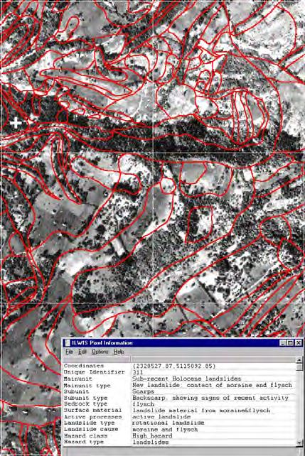
56 Landslide databases Available partly for many countries Often made as a project Continuity is often a problem Very difficult when landslides are multitemporal and reactivated Most are not kept up to date

57 When using landslide data Separate data set: Model data set & validation data set Landslide types & causal mechanism Landslide initiation & deposition Temporal: Period (e.g. decade) Event based (link with return period) Individual dates


58 Damage databases Landslide damage surveys and landslide inventory mapping is crucial for vulnerability assessment E.g. Territory of the National Basin Authority of the Liri-Garigliano and Volturno rivers (about 12,000 km2): landslides, 6450 damage surveys Landslide-induced damage to properties dataset Source: Cascine and Pisciotta
59 Environmental factors You must be able to explain what the relation is with landslide occurrence. Is the factor causing the landslide or resulting from the landslide? Has the factor changed since the landslide occurred? Can the factor be mapped for the whole study area? Does it have a spatial / temporal variability?


60 Environmental parameters Ercanoğlu (2003)

61 Geotechnical/hydrological parameters for dynamic modeling

62 Digital Elevation Data Photogrammetry Existing topomaps Satellite data InSAR LiDAR Many derivative maps from DEMs, but which ones are really useful?
 Slope direction (in")
63 DEM derivatives Altitude Hillshading Slope angles (degrees) Slope direction (in degrees)

64 DEM derivatives Flow accumulation Automatic drainage and catchment delineation Drainage direction


65 Dems from satellite images


66 Slope angle versus landslides SRTM DEM 1:50000 topomap 1:2000 topomap Lidar DEM

67 Use of DEM data
68 Geomorphological maps

69 Very detailed information Based on detailed field mapping

70 Geomorphological data

71 Difficult to store in GIS Store Geomorphological information in several data layers: A: Main Units B: Sub units C: Landslides D: Material types E: Hazard
72 Geological data Lithology: not the stratigraphic information, but engineering geological classification Geological structure: difficult to store in GIS. Actually 3-D GIS is required. Faults / lineaments: which ones are active? Why are faults related to landslides? They might actually move? They are degraded rocks.


73 Which classes to use? Do they have a relation with landslides? Different classes for different methods. E.g Deterministic - statistical Many existing landuse maps should be reclassified Image processing / classification Landuse is both a factor in the hazard assessment well as an element at risk Sometimes better to use landuse change map, than landuse map Landuse data After Coppin and Richards, (1990)
74 ELEMENTS AT RISK Buildings (type, floors, use) Population (age, gender, time of day ) Infrastructure ((rail)roads, utilities) Critical facilities (hospitals, police etc) The environment (forest, natural parks) High potential loss facilities Economic activities (urban, rural..)


75 Elements at risk


76 Elements at risk mapping Using existing data: Cadastral databases Building footprint maps Census data Land use maps Collecting them: Image interpretation (high res.imagery) Field mapping (mobile GIS)


77 Generating an elements at risk database High res image Ward DEM Lidar Contour map Input data Boundaries Mapping units DEM topo Population Landuse Nr Buildings Nr floors Attributes linked to mapping units

78 Different levels of aggregation

 DEM Lidar")


 Risk maps Lands")

79 High res image Ward & census International Institute for Geo-Information Science and Earth Observation (ITC) DEM Lidar Flowchart Thematic layers: Flood discharges Seismic catalogs Soil and rock data Landslide information Technological information etc. Elements at risk Hazard maps Building Attributes: Urban land use Nr of buildings Height of buildings Nr. people (daytime) Nr. people (nighttime) Risk maps Lands lides Flooding Technological Earthquake Risk = Hazard * Vulnerability * Amount Risk curve Lands lides Flooding Technological Earthquake
80 Conclusions Landslide inventory mapping remains crucial for hazard and risk assessment Recent advances in Remote Sensing offer great opportunities in landslide inventory mapping It is time that image interpretation becomes the fashion again: new VHR imagery & Google Earth A landslide database should have info on: Temporal information Landslide types, volumes Damage More effort should be given to designing and maintaining landslide databases Not all data that can be easily obtained are the real useful ones for landslide hazard assessment


81 UNU-ITC DGIM
RiskCity Training package on the Application of GIS for multi- hazard risk assessment in an urban environment.
 RiskCity Training package on the Application of GIS for multi- hazard risk assessment in an urban environment. Cees van Westen (Westen@itc.nl) & Nanette C. Kingma (Kingma@itc.nl) ITC: Training & Research
Landslide Susceptibility, Hazard, and Risk Assessment. Twin Hosea W. K. Advisor: Prof. C.T. Lee
 Landslide Susceptibility, Hazard, and Risk Assessment Twin Hosea W. K. Advisor: Prof. C.T. Lee Date: 2018/05/24 1 OUTLINE INTRODUCTION LANDSLIDE HAZARD ASSESSTMENT LOGISTIC REGRESSION IN LSA STUDY CASE
GEOMATICS. Shaping our world. A company of
 GEOMATICS Shaping our world A company of OUR EXPERTISE Geomatics Geomatics plays a mayor role in hydropower, land and water resources, urban development, transport & mobility, renewable energy, and infrastructure
Landslide Hazard Assessment Methodologies in Romania
 A Scientific Network for Earthquake, Landslide and Flood Hazard Prevention SciNet NatHazPrev Landslide Hazard Assessment Methodologies in Romania In the literature the terms of susceptibility and landslide
2013 Esri Europe, Middle East and Africa User Conference October 23-25, 2013 Munich, Germany
 2013 Esri Europe, Middle East and Africa User Conference October 23-25, 2013 Munich, Germany Environmental and Disaster Management System in the Valles Altos Region in Carabobo / NW-Venezuela Prof.Dr.habil.Barbara
Landslide hazard assessment in the Khelvachauri area, Georgia
 Report on the project of AES Geohazards Stream Landslide hazard assessment in the Khelvachauri area, Georgia May 2010 George Jianping Panisara Gaprindashvili Guo Daorueang Institute of Geo-Information
USING GIS CARTOGRAPHIC MODELING TO ANALYSIS SPATIAL DISTRIBUTION OF LANDSLIDE SENSITIVE AREAS IN YANGMINGSHAN NATIONAL PARK, TAIWAN
 CO-145 USING GIS CARTOGRAPHIC MODELING TO ANALYSIS SPATIAL DISTRIBUTION OF LANDSLIDE SENSITIVE AREAS IN YANGMINGSHAN NATIONAL PARK, TAIWAN DING Y.C. Chinese Culture University., TAIPEI, TAIWAN, PROVINCE
STRATEGY ON THE LANDSLIDE TYPE ANALYSIS BASED ON THE EXPERT KNOWLEDGE AND THE QUANTITATIVE PREDICTION MODEL
 STRATEGY ON THE LANDSLIDE TYPE ANALYSIS BASED ON THE EXPERT KNOWLEDGE AND THE QUANTITATIVE PREDICTION MODEL Hirohito KOJIMA*, Chang-Jo F. CHUNG**, Cees J.van WESTEN*** * Science University of Tokyo, Remote
Uses of free satellite imagery for Disaster Risk Reduction (DRR)
") Centre of Applied Geoscience, Disaster Risk Reduction Research Group, School of Earth and Environmental Science, University of Portsmouth, UK Uses of free satellite imagery for Disaster Risk Reduction
Centre of Applied Geoscience, Disaster Risk Reduction Research Group, School of Earth and Environmental Science, University of Portsmouth, UK Uses of free satellite imagery for Disaster Risk Reduction
Landslide Hazard Zonation Methods: A Critical Review
 International Journal of Civil Engineering Research. ISSN 2278-3652 Volume 5, Number 3 (2014), pp. 215-220 Research India Publications http://www.ripublication.com/ijcer.htm Landslide Hazard Zonation Methods:
EMERGENCY PLANNING IN NORTHERN ALGERIA BASED ON REMOTE SENSING DATA IN RESPECT TO TSUNAMI HAZARD PREPAREDNESS
 EMERGENCY PLANNING IN NORTHERN ALGERIA BASED ON REMOTE SENSING DATA IN RESPECT TO TSUNAMI HAZARD PREPAREDNESS Barbara Theilen-Willige Technical University of Berlin, Institute of Applied Geosciences Department
Environmental Impact Assessment Land Use and Land Cover CISMHE 7.1 INTRODUCTION
 7 LAND USE AND LAND COVER 7.1 INTRODUCTION The knowledge of land use and land cover is important for many planning and management activities as it is considered an essential element for modeling and understanding
Objectives and hypotheses. Remote sensing: applications for landslide hazard assessment and risk management. Ping Lu (University of Firenze) Methods
 Methods") Topical Workshop Remote sensing: applications for landslide hazard assessment and risk management Ping Lu (University of Firenze) Supervisors: Prof. Nicola Casagli; Prof. Filippo Catani (Unifi) Dr. Veronica
Topical Workshop Remote sensing: applications for landslide hazard assessment and risk management Ping Lu (University of Firenze) Supervisors: Prof. Nicola Casagli; Prof. Filippo Catani (Unifi) Dr. Veronica
GIS Application in Landslide Hazard Analysis An Example from the Shihmen Reservoir Catchment Area in Northern Taiwan
 GIS Application in Landslide Hazard Analysis An Example from the Shihmen Reservoir Catchment Area in Northern Taiwan Chyi-Tyi Lee Institute of Applied Geology, National Central University, No.300, Jungda
GIS and Remote Sensing
 Spring School Land use and the vulnerability of socio-ecosystems to climate change: remote sensing and modelling techniques GIS and Remote Sensing Katerina Tzavella Project Researcher PhD candidate Technology
Georeferencing and Satellite Image Support: Lessons learned, Challenges and Opportunities
 Georeferencing and Satellite Image Support: Lessons learned, Challenges and Opportunities Shirish Ravan shirish.ravan@unoosa.org UN-SPIDER United Nations Office for Outer Space Affairs (UNOOSA) UN-SPIDER
DAMAGE DETECTION OF THE 2008 SICHUAN, CHINA EARTHQUAKE FROM ALOS OPTICAL IMAGES
 DAMAGE DETECTION OF THE 2008 SICHUAN, CHINA EARTHQUAKE FROM ALOS OPTICAL IMAGES Wen Liu, Fumio Yamazaki Department of Urban Environment Systems, Graduate School of Engineering, Chiba University, 1-33,
Topographical Change Monitoring for Susceptible Landslide Area Determination by Using Multi-Date Digital Terrain Models and LiDAR
 Topographical Change Monitoring for Susceptible Landslide Area Determination by Using Multi-Date Digital Terrain Models and Chanist PRASERTBURANAKUL 1, Parkorn SUWANICH 2, Kanchana NAKHAPAKORN 3, and Sukit
ASTER DEM Based Studies for Geological and Geomorphological Investigation in and around Gola block, Ramgarh District, Jharkhand, India
 International Journal of Scientific & Engineering Research, Volume 3, Issue 2, February-2012 1 ASTER DEM Based Studies for Geological and Geomorphological Investigation in and around Gola block, Ramgarh
J M MIRANDA UNIVERSITY OF LISBON THE USE OF REMOTE SENSING FOR EARTHQUAKE RISK ASSESSMENT AND MITIGATION
 1 THE USE OF REMOTE SENSING FOR EARTHQUAKE RISK ASSESSMENT AND MITIGATION 2 the observation of strong ground motion and aftershock sequences as well as the investigation of the destruction from these earthquakes
Land Administration and Cadastre
 Geomatics play a major role in hydropower, land and water resources and other infrastructure projects. Lahmeyer International s (LI) worldwide projects require a wide range of approaches to the integration
SPATIAL MODELS FOR THE DEFINITION OF LANDSLIDE SUSCEPTIBILITY AND LANDSLIDE HAZARD. J.L. Zêzere Centre of Geographical Studies University of Lisbon
 SPATIAL MODELS FOR THE DEFINITION OF LANDSLIDE SUSCEPTIBILITY AND LANDSLIDE HAZARD J.L. Zêzere Centre of Geographical Studies University of Lisbon CONCEPTUAL MODEL OF LANDSLIDE RISK Dangerous Phenomena
Remote Sensing and GIS Contribution to. Tsunami Risk Sites Detection. of Coastal Areas in the Mediterranean
 The Third International Conference on Early Warning (EWC III), 26.-29.March 2006 in Bonn Remote Sensing and GIS Contribution to Tsunami Risk Sites Detection of Coastal Areas in the Mediterranean BARBARA
Preparing Landslide Inventory Maps using Virtual Globes
 Introduction: A landslide is the movement of a mass of rock, debris, or earth down a slope, under the influence of gravity. Landslides can be caused by different phenomena, including intense or prolonged
Digital Elevation Models (DEM) / DTM
 / DTM") Digital Elevation Models (DEM) / DTM Uses in remote sensing: queries and analysis, 3D visualisation, classification input Fogo Island, Cape Verde Republic ASTER DEM / image Banks Peninsula, Christchurch,
Digital Elevation Models (DEM) / DTM Uses in remote sensing: queries and analysis, 3D visualisation, classification input Fogo Island, Cape Verde Republic ASTER DEM / image Banks Peninsula, Christchurch,
Landslide Susceptibility Mapping Using Logistic Regression in Garut District, West Java, Indonesia
 Landslide Susceptibility Mapping Using Logistic Regression in Garut District, West Java, Indonesia N. Lakmal Deshapriya 1, Udhi Catur Nugroho 2, Sesa Wiguna 3, Manzul Hazarika 1, Lal Samarakoon 1 1 Geoinformatics
ESRI GIS For Mining Seminar, 10 th August, 2016, Nairobi, Kenya. Spatial DATA Solutions for Mining
 ESRI GIS For Mining Seminar, 10 th August, 2016, Nairobi, Kenya Spatial DATA Solutions for Mining Spatial Data Solutions for Mining Spatial - Data that identifies the geographic location of features &
Outline. Remote Sensing, GIS and DEM Applications for Flood Monitoring. Introduction. Satellites and their Sensors used for Flood Mapping
 Outline Remote Sensing, GIS and DEM Applications for Flood Monitoring Prof. D. Nagesh Kumar Chairman, Centre for Earth Sciences Professor, Dept. of Civil Engg. Indian Institute of Science Bangalore 560
International Conference Analysis and Management of Changing Risks for Natural Hazards November 2014 l Padua, Italy
 Abstract Code: B01 Assets mapping products in support of preparedness and prevention measures (examples from Germany, Italy and France) Marc Mueller, Thierry Fourty, Mehdi Lefeuvre Airbus Defence and Space,
The Safeland Project General Overview and Monitoring Technology Development
 Ber. Geol. B. A., 82, ISSN 1017 8880 Landslide Monitoring Technologies & Early Warning Systems The Safeland Project General Overview and Monitoring Technology Development The SafeLand Consortium a), N.
Applying Hazard Maps to Urban Planning
 Applying Hazard Maps to Urban Planning September 10th, 2014 SAKAI Yuko Disaster Management Expert JICA Study Team for the Metro Cebu Roadmap Study on the Sustainable Urban Development 1 Contents 1. Outline
CNES R&D and available software for Space Images based risk and disaster management
 CNES R&D and available software for Space Images based risk and disaster management 1/21 Contributors: CNES (Centre National d Etudes Spatiales), Toulouse, France Hélène Vadon Jordi Inglada 2/21 Content
Satellite Based Seismic Technology
 Satellite Based Seismic Technology Dr. V.K. Srivastava, R. Ghosh*, B.B Chhualsingh Department of Applied Geophysics, Indian School of mines, Dhanbad. E- mail: ismkvinay@hotmail.com, ghosh.ramesh@rediffmail.com,
Investigation of landslide based on high performance and cloud-enabled geocomputation
 Investigation of landslide based on high performance and cloud-enabled geocomputation Jun Liu 1, Shuguang Liu 2,*, Qiming Zhou 3, Jing Qian 1 1 Shenzhen Institutes of Advanced Technology, Chinese Academy
Natural Terrain Risk Management in Hong Kong
 Natural Terrain Risk Management in Hong Kong Nick Koor Senior Lecturer in Engineering Geology School of Earth and Environmental Sciences Slope failures in Hong Kong Man-made Slope Failure - 300 landslides
Digital Elevation Models (DEM) / DTM
 / DTM") Digital Elevation Models (DEM) / DTM Uses in remote sensing: queries and analysis, 3D visualisation, layers in classification Fogo Island, Cape Verde Republic ASTER DEM / image Banks Peninsula, Christchurch,
Digital Elevation Models (DEM) / DTM Uses in remote sensing: queries and analysis, 3D visualisation, layers in classification Fogo Island, Cape Verde Republic ASTER DEM / image Banks Peninsula, Christchurch,
HIERARCHICAL IMAGE OBJECT-BASED STRUCTURAL ANALYSIS TOWARD URBAN LAND USE CLASSIFICATION USING HIGH-RESOLUTION IMAGERY AND AIRBORNE LIDAR DATA
 HIERARCHICAL IMAGE OBJECT-BASED STRUCTURAL ANALYSIS TOWARD URBAN LAND USE CLASSIFICATION USING HIGH-RESOLUTION IMAGERY AND AIRBORNE LIDAR DATA Qingming ZHAN, Martien MOLENAAR & Klaus TEMPFLI International
Identifying Audit, Evidence Methodology and Audit Design Matrix (ADM)
") 11 Identifying Audit, Evidence Methodology and Audit Design Matrix (ADM) 27/10/2012 Exercise XXX 2 LEARNING OBJECTIVES At the end of this session participants will be able to: 1. Identify types and sources
11 Identifying Audit, Evidence Methodology and Audit Design Matrix (ADM) 27/10/2012 Exercise XXX 2 LEARNING OBJECTIVES At the end of this session participants will be able to: 1. Identify types and sources
Display data in a map-like format so that geographic patterns and interrelationships are visible
 Vilmaliz Rodríguez Guzmán M.S. Student, Department of Geology University of Puerto Rico at Mayagüez Remote Sensing and Geographic Information Systems (GIS) Reference: James B. Campbell. Introduction to
Geo-hazard Potential Mapping Using GIS and Artificial Intelligence
 Geo-hazard Potential Mapping Using GIS and Artificial Intelligence Theoretical Background and Uses Case from Namibia Andreas Knobloch 1, Dr Andreas Barth 1, Ellen Dickmayer 1, Israel Hasheela 2, Andreas
RISK ASSESSMENT METHODOLOGIES FOR LANDSLIDES
 RISK ASSESSMENT METHODOLOGIES FOR LANDSLIDES Jean-Philippe MALET Olivier MAQUAIRE CNRS & CERG. Welcome to Paris! 1 Landslide RAMs Landslide RAM A method based on the use of available information to estimate
Geological Mapping Using EO Data for Onshore O&G Exploration
 Geological Mapping Using EO Data for Onshore O&G Exploration Michael Hall ESA Oil and Gas Workshop, Frascati, Italy michael.hall@infoterra-global.com Why use EO data for Geological Mapping? Availability
Hendra Pachri, Yasuhiro Mitani, Hiro Ikemi, and Ryunosuke Nakanishi
 21 2nd International Conference on Geological and Civil Engineering IPCBEE vol. 8 (21) (21) IACSIT Press, Singapore DOI: 1.7763/IPCBEE. 21. V8. 2 Relationships between Morphology Aspect and Slope Failure
Copernicus Overview. Major Emergency Management Conference Athlone 2017
 Copernicus Overview Major Emergency Management Conference Athlone 2017 Copernicus is a European programme implemented by the European Commission. The services address six thematic areas: land, marine,
Advanced Geospatial Data for Cascading Geo-Hazard and Disaster Risk Assessment: A case study of 2015 earthquakes in Sabah
 Advanced Geospatial Data for Cascading Geo-Hazard and Disaster Risk Assessment: A case study of 2015 earthquakes in Sabah Presented at the FIG Working Week 2016, May 2-6, 2016 in Christchurch, New Zealand
Themes for Geomatics Conference. Geodesy Themes
 Themes for Geomatics Conference Geodesy Themes Geodynamics o Modeling the Deformation of the Earth s Crust o Recent Advances in Geometric Approaches to Deformation Analysis o Monitoring Systems (Sensors
USING LIDAR MEASUREMENTS FOR IMPROVING OR UP-DATING A DEM
 JAES_1(14)_3_2011 VAIS M. et. all, pp.123-128 SECTION Geodesic Engineering USING LIDAR MEASUREMENTS FOR IMPROVING OR UP-DATING A DEM VAIS Manuel*, IOSIF Gheorghe, Bucharest University, *e-mail: manuel.vais@sipg.ro
Natural Hazards Large and Small
 Specialty Seminar on Engineering of Geo-Hazards ASCE Met Section Geotechnical Group and Geo-Institute of ASCE 16 May 2007 Natural Hazards Large and Small Evaluation and Mitigation Edward Kavazanjian, Jr.,
Contemporary Data Collection and Spatial Information Management Techniques to support Good Land Policies
 Contemporary Data Collection and Spatial Information Management Techniques to support Good Land Policies Ch. Ioannidis Associate Professor FIG Commission 3 Workshop Paris, 25-28 October 2011 Introduction
Quick Response Report #126 Hurricane Floyd Flood Mapping Integrating Landsat 7 TM Satellite Imagery and DEM Data
 Quick Response Report #126 Hurricane Floyd Flood Mapping Integrating Landsat 7 TM Satellite Imagery and DEM Data Jeffrey D. Colby Yong Wang Karen Mulcahy Department of Geography East Carolina University
GEOMATICS AND DISASTER MANAGEMENT: Early Impact assessment in Haiti
 GEOMATICS AND DISASTER MANAGEMENT: Early Impact assessment in Haiti We will talk about... Post-disaster response: the main questions to be answered Post-disaster rapid mapping: the role of Geomatics The
LANDSLIDE SUSCEPTIBILITY MAPPING USING INFO VALUE METHOD BASED ON GIS
 LANDSLIDE SUSCEPTIBILITY MAPPING USING INFO VALUE METHOD BASED ON GIS ABSTRACT 1 Sonia Sharma, 2 Mitali Gupta and 3 Robin Mahajan 1,2,3 Assistant Professor, AP Goyal Shimla University Email: sonia23790@gmail.com
Practical reliability approach to urban slope stability
 University of Wollongong Research Online Faculty of Engineering - Papers (Archive) Faculty of Engineering and Information Sciences 2011 Practical reliability approach to urban slope stability R. Chowdhury
Land Use / Land Cover Mapping in
 Land Use / Land Cover Mapping in Eastern and Southern African Regions RCMRD Experience by 6/24/2013, Nairobi Kenya Dr. Tesfaye Korme Director of RS, GIS and Mapping, RCMRD I. About RCMRD, Its Vision and
Terranum Sàrl. Rock-solid Expertise and Software
 Terranum Sàrl Rock-solid Expertise and Software About Founded in May 2011, Terranum Sàrl develops rock-solid expertise for natural hazards, geology, hydrology, 3D and LiDAR measurements, and customized
PROANA A USEFUL SOFTWARE FOR TERRAIN ANALYSIS AND GEOENVIRONMENTAL APPLICATIONS STUDY CASE ON THE GEODYNAMIC EVOLUTION OF ARGOLIS PENINSULA, GREECE.
 PROANA A USEFUL SOFTWARE FOR TERRAIN ANALYSIS AND GEOENVIRONMENTAL APPLICATIONS STUDY CASE ON THE GEODYNAMIC EVOLUTION OF ARGOLIS PENINSULA, GREECE. Spyridoula Vassilopoulou * Institute of Cartography
Vulnerability mapping for sustainable hazard mitigation in the city of Bukavu, South Kivu DRCongo
 IAG/AIG REGIONAL CONFERENCE, 18th to 22nd Feb. 2011 Vulnerability mapping for sustainable hazard mitigation in the city of Bukavu, South Kivu DRCongo Sadiki Ndyanabo 1, Ine Vandecasteele 2, Jan Moeyersons
Application of high-resolution (10 m) DEM on Flood Disaster in 3D-GIS
 DEM on Flood Disaster in 3D-GIS") Risk Analysis V: Simulation and Hazard Mitigation 263 Application of high-resolution (10 m) DEM on Flood Disaster in 3D-GIS M. Mori Department of Information and Computer Science, Kinki University, Japan
Risk Analysis V: Simulation and Hazard Mitigation 263 Application of high-resolution (10 m) DEM on Flood Disaster in 3D-GIS M. Mori Department of Information and Computer Science, Kinki University, Japan
CHAPTER 3 LANDSLIDE HAZARD ZONATION
 43 CHAPTER 3 LANDSLIDE HAZARD ZONATION 3.1 GENERAL Landslide hazard is commonly shown on maps, which display the spatial distribution of hazard classes (Landslide Hazard Zonation). Landslide hazard zonation
CHANGE DETECTION USING REMOTE SENSING- LAND COVER CHANGE ANALYSIS OF THE TEBA CATCHMENT IN SPAIN (A CASE STUDY)
") CHANGE DETECTION USING REMOTE SENSING- LAND COVER CHANGE ANALYSIS OF THE TEBA CATCHMENT IN SPAIN (A CASE STUDY) Sharda Singh, Professor & Programme Director CENTRE FOR GEO-INFORMATICS RESEARCH AND TRAINING
CHANGE DETECTION USING REMOTE SENSING- LAND COVER CHANGE ANALYSIS OF THE TEBA CATCHMENT IN SPAIN (A CASE STUDY) Sharda Singh, Professor & Programme Director CENTRE FOR GEO-INFORMATICS RESEARCH AND TRAINING
Figure B.15 - Example of plotting the landslide potential points
 Figure B.15 - Example of plotting the landslide potential points Figure B.16 - Example of landslide potential map based on topographic factor in north area of kabupaten Jember 37 from 61 Figure B.17 -
Ramani Geosystems. Putting Africa On The Map. Authorized Resellers
 Ramani Geosystems Putting Africa On The Map Authorized Resellers Ramani Profile Started in 1999 Aerial, Land Surveying & Mapping Solutions + 10 Countries in the region + 80 Staff working in projects Asset
TESTING ON THE TIME-ROBUSTNESS OF A LANDSLIDE PREDICTION MODEL. Hirohito Kojima* and Chang-Jo F. Chung**
 TESTING ON THE TIME-ROBUSTNESS OF A LANDSLIDE PREDICTION MODEL Hirohito Kojima* and Chang-Jo F. Chung** *: Science University of Tokyo, Remote Sensing Lab., Dept. of Civil Engineering 2641 Yamazaki, Noda-City,
Scientific registration n : 2180 Symposium n : 35 Presentation : poster MULDERS M.A.
 Scientific registration n : 2180 Symposium n : 35 Presentation : poster GIS and Remote sensing as tools to map soils in Zoundwéogo (Burkina Faso) SIG et télédétection, aides à la cartographie des sols
Criteria for identification of areas at risk of landslides in Europe: the Tier 1 approach
 Criteria for identification of areas at risk of landslides in Europe: the Tier 1 approach Andreas Günther 1, Paola Reichenbach 2, Fausto Guzzetti 2, Andreas Richter 1 1 Bundesanstalt für Geowissenschaften
LANLDSIDE HAZARD, SOCIAL-ECONOMIC VULNERABILITY AND PHYSICAL (BUILDINGS) RISK ASSESMENT SAGAREJO MUNICIPALITY CASE STUDY (PROJECT)
 RISK ASSESMENT SAGAREJO MUNICIPALITY CASE STUDY (PROJECT)") LANLDSIDE HAZARD, SOCIAL-ECONOMIC VULNERABILITY AND PHYSICAL (BUILDINGS) RISK ASSESMENT SAGAREJO MUNICIPALITY CASE STUDY (PROJECT) - 1 - 1. INTRODUCTION 3 2. USED DATA 4 3. METHODOLOGY 5 3.1 Work flow
LANLDSIDE HAZARD, SOCIAL-ECONOMIC VULNERABILITY AND PHYSICAL (BUILDINGS) RISK ASSESMENT SAGAREJO MUNICIPALITY CASE STUDY (PROJECT) - 1 - 1. INTRODUCTION 3 2. USED DATA 4 3. METHODOLOGY 5 3.1 Work flow
COMPREHENSIVE GIS-BASED SOLUTION FOR ROAD BLOCKAGE DUE TO SEISMIC BUILDING COLLAPSE IN TEHRAN
 COMPREHENSIVE GIS-BASED SOLUTION FOR ROAD BLOCKAGE DUE TO SEISMIC BUILDING COLLAPSE IN TEHRAN B. Mansouri 1, R. Nourjou 2 and K.A. Hosseini 3 1 Assistant Professor, Dept. of Emergency Management, International
Bonn, Germany MOUTAZ DALATI. General Organization for Remote Sensing ( GORS ), Syria Advisor to the General Director of GORS,
, Syria Advisor to the General Director of GORS,") Bonn, Germany Early Warning System is needed for Earthquakes disaster mitigation in Syria Case Study: Detecting and Monitoring the Active faulting zones along the Afro-Arabian-Syrian Rift System MOUTAZ
Bonn, Germany Early Warning System is needed for Earthquakes disaster mitigation in Syria Case Study: Detecting and Monitoring the Active faulting zones along the Afro-Arabian-Syrian Rift System MOUTAZ
USE OF SATELLITE IMAGES FOR AGRICULTURAL STATISTICS
 USE OF SATELLITE IMAGES FOR AGRICULTURAL STATISTICS National Administrative Department of Statistics DANE Colombia Geostatistical Department September 2014 Colombian land and maritime borders COLOMBIAN
7.1 INTRODUCTION 7.2 OBJECTIVE
 7 LAND USE AND LAND COVER 7.1 INTRODUCTION The knowledge of land use and land cover is important for many planning and management activities as it is considered as an essential element for modeling and
Advanced Image Analysis in Disaster Response
 Advanced Image Analysis in Disaster Response Creating Geographic Knowledge Thomas Harris ITT The information contained in this document pertains to software products and services that are subject to the
Automatic Change Detection from Remote Sensing Stereo Image for Large Surface Coal Mining Area
 doi: 10.14355/fiee.2016.05.003 Automatic Change Detection from Remote Sensing Stereo Image for Large Surface Coal Mining Area Feifei Zhao 1, Nisha Bao 2, Baoying Ye 3, Sizhuo Wang 4, Xiaocui Liu 5, Jianyan
Viale della Fiera 8 Bologna - Italy
 Assessment of landslides susceptibility and reactivation likelihood in the Emilia Romagna region (Italy) Mauro Generali e Marco Pizziolo Regione Emilia-Romagna Geological Survey Viale della Fiera 8 Bologna
Eyes in the Sky & Data Analysis.
 Eyes in the Sky & Data Analysis How can we collect Information about Earth Climbing up Trees & Mountains Gathering Food Self Protection Understanding Surroundings By Travelling Collected Information Converted
Digital Elevation Models (DEM)
") Digital Elevation Models (DEM) Digital representation of the terrain surface enable 2.5 / 3D views Rule #1: they are models, not reality Rule #2: they always include some errors (subject to scale and data
Digital Elevation Models (DEM) Digital representation of the terrain surface enable 2.5 / 3D views Rule #1: they are models, not reality Rule #2: they always include some errors (subject to scale and data
Spatial Support in Landslide Hazard Predictions Based on Map Overlays
 Spatial Support in Landslide Hazard Predictions Based on Map Overlays Andrea G. Fabbri International Institute for Aerospace Survey and Earth Sciences (ITC), Hengelosestraat 99, 7500 AA Enschede, The Netherlands
Quantitative assessment of landslide susceptibility using high-resolution remote sensing data and a generalized additive model
 International Journal of Remote Sensing Vol. 29, No. 1, 10 January 2008, 247 264 Quantitative assessment of landslide susceptibility using high-resolution remote sensing data and a generalized additive
LANDSLIDE FEATURES INTERPRETED BY NEURAL NETWORK METHOD USING A HIGH-RESOLUTION SATELLITE IMAGE AND DIGITAL TOPOGRAPHIC DATA
 LANDSLIDE FEATURES INTERPRETED BY NEURAL NETWORK METHOD USING A HIGH-RESOLUTION SATELLITE IMAGE AND DIGITAL TOPOGRAPHIC DATA K. T. Chang a * and J. K. Liu b a Dept. of Civil Eng., MUST, No. 1, Hsin-Hsing
EO Information Services. Assessing Vulnerability in the metropolitan area of Rio de Janeiro (Floods & Landslides) Project
 Project") EO Information Services in support of Assessing Vulnerability in the metropolitan area of Rio de Janeiro (Floods & Landslides) Project Ricardo Armas, Critical Software SA Haris Kontoes, ISARS NOA World
EO Information Services in support of Assessing Vulnerability in the metropolitan area of Rio de Janeiro (Floods & Landslides) Project Ricardo Armas, Critical Software SA Haris Kontoes, ISARS NOA World
Identifying Landslides Using Google Earth
 Identifying Landslides (This draft updated on 1 Dec 2014) Page 1 of 15 1. Introduction Identifying Landslides Using Google Earth 1.1. Workshop Aims 1. Identify landslides from Google Earth images 2. Approximate
This module presents remotely sensed assessment (choice of sensors and resolutions; airborne or ground based sensors; ground truthing)
") This module presents remotely sensed assessment (choice of sensors and resolutions; airborne or ground based sensors; ground truthing) 1 In this presentation you will be introduced to approaches for using
This module presents remotely sensed assessment (choice of sensors and resolutions; airborne or ground based sensors; ground truthing) 1 In this presentation you will be introduced to approaches for using
Use of Geospatial data for disaster managements
 Use of Geospatial data for disaster managements Source: http://alertsystemsgroup.com Instructor : Professor Dr. Yuji Murayama Teaching Assistant : Manjula Ranagalage What is GIS? A powerful set of tools
LANDSLIDE HAZARD ZONATION IN AND AROUND KEDARNATH REGION AND ITS VALIDATION BASED ON REAL TIME KEDARNATH DISASTER USING GEOSPATIAL TECHNIQUES
 LANDSLIDE HAZARD ZONATION IN AND AROUND KEDARNATH REGION AND ITS VALIDATION BASED ON REAL TIME KEDARNATH DISASTER USING GEOSPATIAL TECHNIQUES Divya Uniyal 1,*, Saurabh Purohit 2, Sourabh Dangwal 1, Ashok
International Journal of Modern Trends in Engineering and Research e-issn No.: , Date: April, 2016
 International Journal of Modern Trends in Engineering and Research www.ijmter.com e-issn No.:2349-9745, Date: 28-30 April, 2016 Landslide Hazard Management Maps for Settlements in Yelwandi River Basin,
Spanish national plan for land observation: new collaborative production system in Europe
 ADVANCE UNEDITED VERSION UNITED NATIONS E/CONF.103/5/Add.1 Economic and Social Affairs 9 July 2013 Tenth United Nations Regional Cartographic Conference for the Americas New York, 19-23, August 2013 Item
Geospatial Approach for Delineation of Landslide Susceptible Areas in Karnaprayag, Chamoli district, Uttrakhand, India
 Geospatial Approach for Delineation of Landslide Susceptible Areas in Karnaprayag, Chamoli district, Uttrakhand, India Ajay Kumar Sharma & Anand Mohan Singh Overview Landslide - movement of a mass of rock,
Emergency preparedness tools for landslides
 http://omiv.unistra.fr Emergency preparedness tools for landslides A. Remaître, J.-P. Malet, S. Sterlacchinni, A. Pasuto Institut de Physique du Globe, Université de Strasbourg, Strasbourg, France CERG,
AUTOMATED BUILDING DETECTION FROM HIGH-RESOLUTION SATELLITE IMAGE FOR UPDATING GIS BUILDING INVENTORY DATA
 13th World Conference on Earthquake Engineering Vancouver, B.C., Canada August 1-6, 2004 Paper No. 678 AUTOMATED BUILDING DETECTION FROM HIGH-RESOLUTION SATELLITE IMAGE FOR UPDATING GIS BUILDING INVENTORY
GIS = Geographic Information Systems;
 What is GIS GIS = Geographic Information Systems; What Information are we talking about? Information about anything that has a place (e.g. locations of features, address of people) on Earth s surface,
Landslide Susceptibility Model of Tualatin Mountains, Portland Oregon. By Tim Cassese and Colby Lawrence December 10, 2015
 Landslide Susceptibility Model of Tualatin Mountains, Portland Oregon By Tim Cassese and Colby Lawrence December 10, 2015 Landslide Closes Highway 30 at St. John's Bridge Introduction: Study Area: Tualatin
Introduction. Elevation Data Strategy. Status and Next Steps
 1 2 Introduction Elevation Data Strategy Status and Next Steps 3 Canada is the 2nd largest country in the world - 9.9 million sq km Surrounded by 3 oceans with 202 000 km of coastline Population over 35
Evaluating Urban Vegetation Cover Using LiDAR and High Resolution Imagery
 Evaluating Urban Vegetation Cover Using LiDAR and High Resolution Imagery Y.A. Ayad and D. C. Mendez Clarion University of Pennsylvania Abstract One of the key planning factors in urban and built up environments
Pinyol, Jordi González, Marta Oller, Pere Corominas, Jordi Martínez, Pere
 Rockfall hazard mapping methodology applied to the Geological Hazard Prevention Map in Catalonia 1:25000 Pinyol, Jordi González, Marta Oller, Pere Corominas, Jordi Martínez, Pere ROCKFALL HAZARD MAPPING
!" &#'(&) %*!+,*" -./0"1$ 1% % % - % 8 99:; < % % % % = 1. % % 2 /0 2 8 $ ' 99!; & %% % 2,A 1% %,1 % % % 2 3 %3 % / % / "1 % ; /0 % 2% % % %36
 %*!+,* -./01$ 1% % % - % 8 99:; < % % % % = 1. % % 2 /0 2 8 $ ' 99!; & %% % 2,A 1% %,1 % % % 2 3 %3 % / % / 1 % ; /0 % 2% % % %36") !" #$ &#'(&) *!+,*" - /0"1$ 1 1/0/// 0/02 /04"1 /0//,1$ 5/ - ( 6/027/ ///0 (/0// // - /002220(2 8 99:; < (/ = 1 2 /0$17899; 2 /0 2 8 $ 99?6 @ ' 99!; & 2,A 1,1 2 / / "1 -,14/02- ; /0 2 6,; B,1$ 2"1/0
!" #$ &#'(&) *!+,*" - /0"1$ 1 1/0/// 0/02 /04"1 /0//,1$ 5/ - ( 6/027/ ///0 (/0// // - /002220(2 8 99:; < (/ = 1 2 /0$17899; 2 /0 2 8 $ 99?6 @ ' 99!; & 2,A 1,1 2 / / "1 -,14/02- ; /0 2 6,; B,1$ 2"1/0
Applications of Remote Sensing Systems. to MINERAL DEPOSIT DISCOVERY, DEVELOPMENT
 REMS 6022: Term Project Applications of Remote Sensing Systems to MINERAL DEPOSIT DISCOVERY, DEVELOPMENT and RECLAMATION Venessa Bennett OVERVIEW Remote Sensing data extensively used in all aspects of
Topographic Laser Scanning of Landslide Geomorphology System: Some Practical and Critical Issues
 Topographic Laser Scanning of Landslide Geomorphology System: Some Practical and Critical Issues Khamarrul Azahari Razak, Rozaimi Che Hasan UTM Razak School of Engineering and Advanced Technology, UTM
Earthquake Emergency Preparedness in Central-Hungary
 UN-SPIDER Fourth United Nations International UN-SPIDER Bonn Workshop on Disaster Management and Space Technology: The 4C Challenge:Communication Coordination Cooperation Capacity Development Bonn, Germany,
Positional accuracy of the drainage networks extracted from ASTER and SRTM for the Gorongosa National Park region - Comparative analysis
 Positional accuracy of the drainage networks extracted from ASTER and SRTM for the Gorongosa National Park region - Comparative analysis Tiago CARMO 1, Cidália C. FONTE 1,2 1 Departamento de Matemática,
LANDSLIDE IDENTIFICATION, MOVEMENT MONITORING AND RISK ASSESSMENT USING ADVANCED EARTH OBSERVATION TECHNIQUES
 LANDSLIDE IDENTIFICATION, MOVEMENT MONITORING AND RISK ASSESSMENT USING ADVANCED EARTH OBSERVATION TECHNIQUES European Leader Investigator Dr. Zbigniew Perski Carpathian Branch, Polish Geological Institute
GEOGRAPHY (029) CLASS XI ( ) Part A: Fundamentals of Physical Geography. Map and Diagram 5. Part B India-Physical Environment 35 Marks
 CLASS XI ( ) Part A: Fundamentals of Physical Geography. Map and Diagram 5. Part B India-Physical Environment 35 Marks") GEOGRAPHY (029) CLASS XI (207-8) One Theory Paper 70 Marks 3 Hours Part A Fundamentals of Physical Geography 35 Marks Unit-: Geography as a discipline Unit-3: Landforms Unit-4: Climate Unit-5: Water (Oceans)
GEOGRAPHY (029) CLASS XI (207-8) One Theory Paper 70 Marks 3 Hours Part A Fundamentals of Physical Geography 35 Marks Unit-: Geography as a discipline Unit-3: Landforms Unit-4: Climate Unit-5: Water (Oceans)