Landslide Susceptibility Model of Tualatin Mountains, Portland Oregon. By Tim Cassese and Colby Lawrence December 10, 2015
|
|
|
- Jasper Shaw
- 5 years ago
- Views:
Transcription
1 Landslide Susceptibility Model of Tualatin Mountains, Portland Oregon By Tim Cassese and Colby Lawrence December 10, 2015
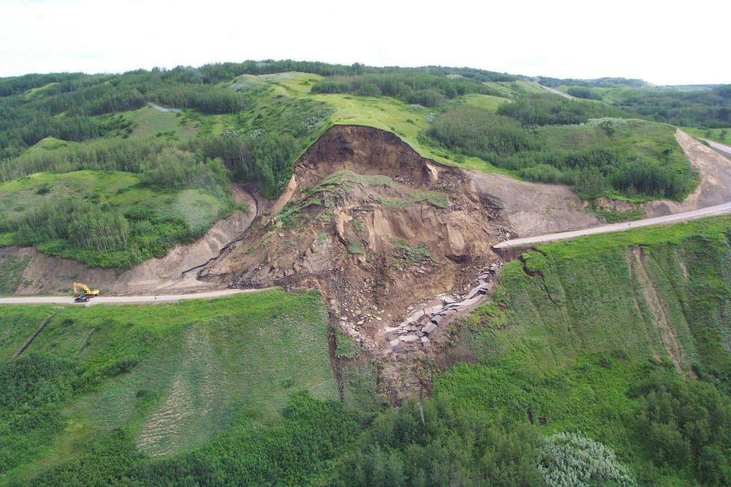
2 Landslide Closes Highway 30 at St. John's Bridge
3 Introduction:
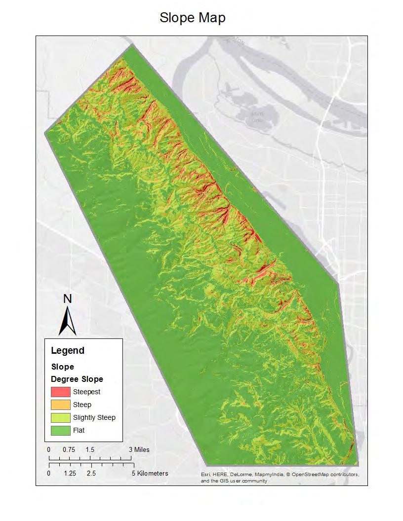
4 Study Area: Tualatin Mountains (West Hills) Portland, Or Range up to 1,270 feet (Cornell Mountain) Steep slopes and periodic landslides Multiple earthquake faults Many residences and roads despite risks Increasing precipitation due to climate change in an area of already high precipitation Urban growth due to influx of people puts population and property at risk.
5 Causes Groundwater Pressure Loss or lack of vegetation Erosion Earthquakes and volcanic eruptions Deforestation Machinery, traffic and blasting Construction
6 Debris Flow Types Earthflow Debris Landslide Sturzstrom Shallow Landslide Deep-seated Landslide
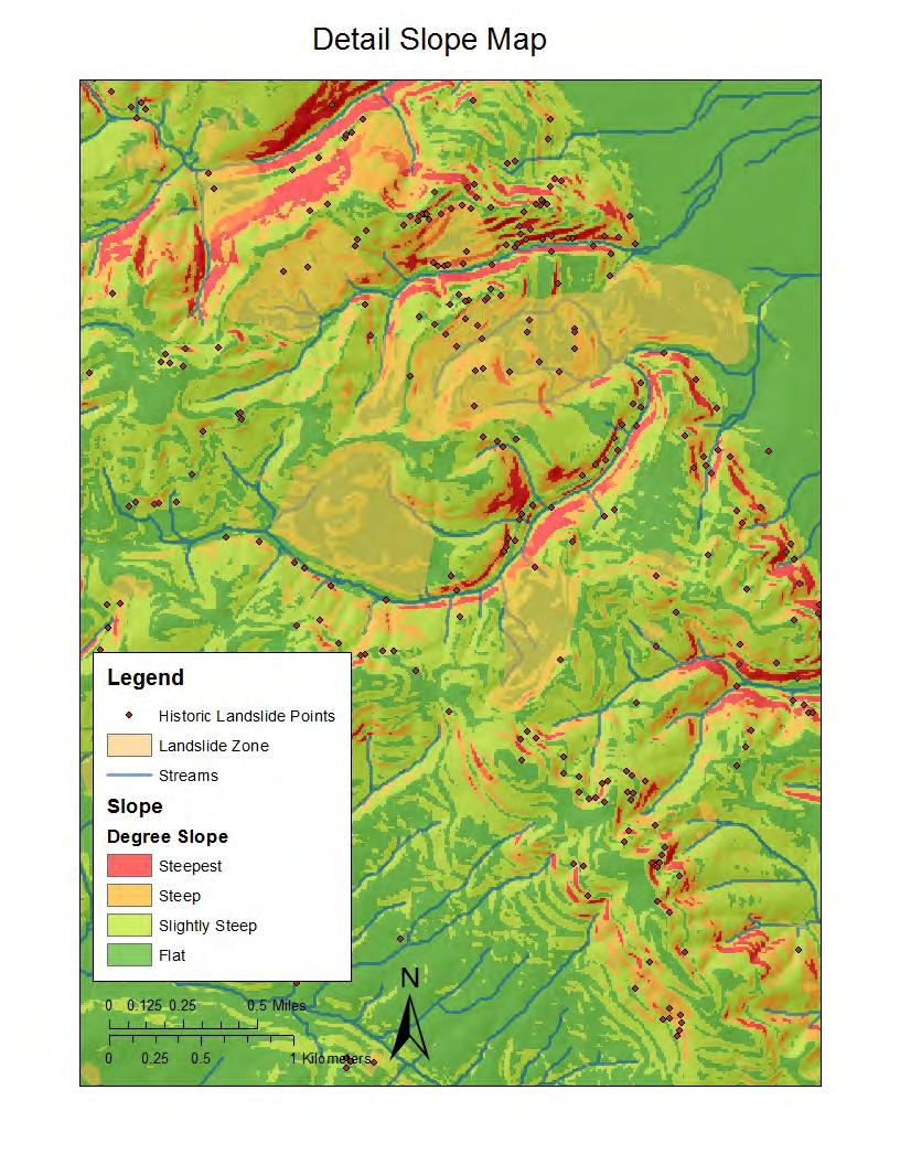
7 Purpose of Susceptibility Analysis Analyze a series of metrics that directly influence the landslide susceptibility in our study area and combine these factors into a final susceptibility map that shows a weighted combination of risk factors showing the areas that are most (and least) likely to generate landslides. We hypothesized that areas found to be prone to landslides in our analysis would correlate with historic landslides in the area.
8 Data and Sources Historic landslide data from Statewide Landslide Information Database for Oregon (SLIDO) DEM from Portland State University (PSU) Soil data from Orergon Geospatial Enterprise Office (GEO) Fault lines, scarps and deposits from Oregon Spatial Data Library (OSDL) PRISM Precipitation normalized 30 year monthly average from Oregon State University (OSU) Land cover data from National Land Cover Database (NLCD)
9 Methodology Reclassify datasets to a common scale according to geospatial aspects that influence landslides
10
11
12

13
14
15
16
17
18
19
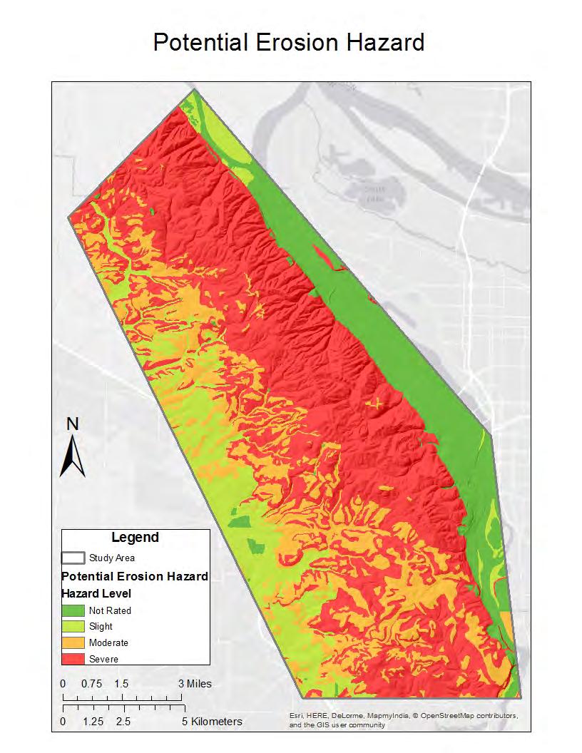
20 Methodology After our 8 datasets were reclassified and given a numeric value between 1 and 4 for landslide susceptibility we used raster calculator to create a simple equation to weight and combine the raster into a final susceptibility map. Slope, erosion, land cover and historic landslides were multiplied by.15, while drainage, aspect, precipitation and fault distance were multiplied by.1, giving the first four datasets twice the weight of the others. After this all of the rasters were added together creating a cohesive susceptibility map.

21
22 Discussion The index shows strong correlation with prior landslides and therefore our hypothesis looks to be correct and we seem to have a degree of accuracy in our results. This study isn t scientific enough to be used for city planning or actual mitigation practices. Susceptibility is an initial step before analyzing landslide run out, and then landslide consequences for an area.
23 Conclusion Landslide Susceptibility Indices and analysis provide a good starting point for finding problem areas when it comes to predicting possible landslides but are limited in accuracy and omit some crucial factors necessary for protecting people and property from landslides. Never the less our methods provided a seemingly accurate result in predicting high-risk zones for landslide occurrence.
24 Possible Improvements More data and better classification of landslide causal factors for more accurate analysis. Wildfire data as wildfires strongly influence landslides. Further analysis of run out and expected consequences of landslides occurring in high-risk zones of study areas Formulation of a more scientific weighting scale to create even more accurate results. Take it further with statistical analysis.
25 Questions?
26 References Literature Cees Van Westen. Landslide susceptibility Assessment, N.D. Retrieved from Susceptibility.pdf Dept. of Landslide Conservation and Development. Oregon Landslide Background, N.D. Retrieved from J.D. Jimenez-Pera lvarez, et al. Building models for automatic landslide-susceptibility analysis, mapping and validation in ArcGIS, October, Retrieved from Michael Olsen. Map outlines western Oregon landslide risks from a subduction zone earthquake, Feb, Retrieved from Oregon State University. Landslide Susceptibility Lab, N.D. Retrieved from Sunset, Sunset climate zones: Western Oregon, N.D. Retrieved from U.S Geological Survey. United States Estimated Losses, November, Retrieved from William J. Burns and Ian P. Madin PROTOCOL FOR INVENTORY MAPPING OF LANDSLIDE DEPOSITS FROM LIGHT DETECTION AND RANGING (LIDAR) IMAGERY, Retrieved from Data DOGAMI. Slido 3.2 Geodatabase, December, Retrieved from Oregon Spatial Data Library. OR Geologic Data Compilation, Retrieved from 4A131287A309%7D Oregon SSURGO STATSGO. Soil Compilation, Retrieved from Multi-Resolution Land Characteristics Consortium. NLCD 2011 Land Cover, Retrieved from
Eagle Creek Post Fire Erosion Hazard Analysis Using the WEPP Model. John Rogers & Lauren McKinney
 Eagle Creek Post Fire Erosion Hazard Analysis Using the WEPP Model John Rogers & Lauren McKinney Columbia River Gorge at Risk: Using LiDAR and GIS-based predictive modeling for regional-scale erosion susceptibility
Need of Proper Development in Hilly Urban Areas to Avoid
 Need of Proper Development in Hilly Urban Areas to Avoid Landslide Hazard Dr. Arvind Phukan, P.E. Cosultant/Former Professor of Civil Engineering University of Alaska, Anchorage, USA RI District Governor
Identifying Wildfire Risk Areas in Western Washington State
 Identifying Wildfire Risk Areas in Western Washington State Matthew Seto University of Washington Tacoma GIS Certification Program URISA 2015 Undergraduate Geospatial Skills Competition Introduction 2014
INTRODUCTION Landslides are bad but good
 Mapping Current and Future Landslide Susceptibility with GIS for the Tualatin Mountains, Oregon, USA Ian Cogar Jesse Roper INTRODUCTION Landslides are bad but good Avg. Annual Cost $2 billion and 20 50
Erosion Susceptibility in the area Around the Okanogan Fire Complex, Washington, US
 Erosion Susceptibility in the area Around the Okanogan Fire Complex, Washington, US 1. Problem Construct a raster that represents susceptibility to erosion based on lithology, slope, cover type, burned
Alaska, USA. Sam Robbins
 Using ArcGIS to determine erosion susceptibility within Denali National Park, Alaska, USA Sam Robbins Introduction Denali National Park is six million acres of wild land with only one road and one road
By Chris Mikes and David Fleck Digital Terrain Analysis GEOG 593. Overview
 Earthquake and Infrastructure Damage Analysis in Multnomah and Clackamas Counties: The Application of LiDAR In The Development of an Emergency Response Plan By Chris Mikes and David Fleck Digital Terrain
Oregon APA Legal Issues Workshop December 7, Tricia Sears, DLCD With information from Bill Burns, DOGAMI
 Oregon APA Legal Issues Workshop December 7, 2018 Tricia Sears, DLCD With information from Bill Burns, DOGAMI How this Topic Arrived WE FREQUENTLY HEAR CONCERNS ABOUT LIABILITY AND TAKINGS. Current federal
Landslide & Coastal Erosion Risk Reduction at Oregon s Water/Wastewater Networks
 Landslide & Coastal Erosion Risk Reduction at Oregon s Water/Wastewater Networks Laura Gabel, RG (with Bill Burns, RG & Jonathan Allan, Ph. D) Oregon Department of Geology and Mineral Industries (541)
AN APPROACH TO THE CLASSIFICATION OF SLOPE MOVEMENTS
 Training/workshop on Earthquake Vulnerability and Multi-Hazard Risk Assessment: Geospatial Tools for Rehabilitation and Reconstruction Effort 13 31 March 2006, Islamabad, Pakistan AN APPROACH TO THE CLASSIFICATION
RISK ASSESSMENT COMMUNITY PROFILE NATURAL HAZARDS COMMUNITY RISK PROFILES. Page 13 of 524
 RISK ASSESSMENT COMMUNITY PROFILE NATURAL HAZARDS COMMUNITY RISK PROFILES Page 13 of 524 Introduction The Risk Assessment identifies and characterizes Tillamook County s natural hazards and describes how
11.0 APPENDIX D: SLIDO-3.0 GEODATABASE STRUCTURE AND UPDATE PROCEDURE
 11.0 APPENDIX D: SLIDO-3.0 GEODATABASE STRUCTURE AND UPDATE PROCEDURE 11.1 Structure We created the SLIDO-3.0 file geodatabase with Esri ArcView version 10.0 software. The projection is NAD- 1983HARN Oregon
PROTOCOL FOR DEEP LANDSLIDE SUSCEPTIBILITY MAPPING
 State of Oregon Oregon Department of Geology and Mineral Industries Brad Avy, State Geologist SPECIAL PAPER 48 PROTOCOL FOR DEEP LANDSLIDE SUSCEPTIBILITY MAPPING by William J. Burns 1 and Katherine A.
Interpretive Map Series 24
 Oregon Department of Geology and Mineral Industries Interpretive Map Series 24 Geologic Hazards, and Hazard Maps, and Future Damage Estimates for Six Counties in the Mid/Southern Willamette Valley Including
PUBLIC COMMENT DRAFT 11/07/2016
 3.3 Landslide Much of the northwest portion of Multnomah County is prone to very large and deep landslides. These types of slides tend to move slowly and rip apart infrastructure. The cities of Gresham
5/3/2018 Susceptibility analysis of landslide due to earthquake due in Gorkha (25th April 2015) Animesh Bahadur Pradhan GIS IN WATER RESOURCES CE 547
 Animesh Bahadur Pradhan GIS IN WATER RESOURCES CE 547") Susceptibility 5/3/2018 analysis of landslide due to earthquake due in Gorkha (25th April 2015) Animesh Bahadur Pradhan GIS IN WATER RESOURCES CE 547 Contents 1. Acknowledgement:... 2 2. Motivation and
Susceptibility 5/3/2018 analysis of landslide due to earthquake due in Gorkha (25th April 2015) Animesh Bahadur Pradhan GIS IN WATER RESOURCES CE 547 Contents 1. Acknowledgement:... 2 2. Motivation and
Landslide Hazard and Risk Study of Central and Western Multnomah County, Oregon
 Cover page: Landslide risk and hazards for a portion of the study area. Layers from top to bottom: Assets (buildings and transportation routes), landslide inventory, shallow landslide susceptibility, and
Applying Hazard Maps to Urban Planning
 Applying Hazard Maps to Urban Planning September 10th, 2014 SAKAI Yuko Disaster Management Expert JICA Study Team for the Metro Cebu Roadmap Study on the Sustainable Urban Development 1 Contents 1. Outline
Prepared By: John Blair Sean Donahue Celeste Hoffman Kimberly Klinkers Megan Slater
 Prepared By: John Blair Sean Donahue Celeste Hoffman Kimberly Klinkers Megan Slater Green River Basin Location Green River Basin Stratigraphic Correlation Chart showing Study Map Units Sample of Existing
2013 Esri Europe, Middle East and Africa User Conference October 23-25, 2013 Munich, Germany
 2013 Esri Europe, Middle East and Africa User Conference October 23-25, 2013 Munich, Germany Environmental and Disaster Management System in the Valles Altos Region in Carabobo / NW-Venezuela Prof.Dr.habil.Barbara
Response on Interactive comment by Anonymous Referee #1
 Response on Interactive comment by Anonymous Referee #1 Sajid Ali First, we would like to thank you for evaluation and highlighting the deficiencies in the manuscript. It is indeed valuable addition and
Lidar Illustrated 2012 CALENDAR OREGON DEPARTMENT OF GEOLOGY AND MINERAL INDUSTRIES
 Lidar Illustrated 2012 CALENDAR OREGON DEPARTMENT OF GEOLOGY AND MINERAL INDUSTRIES Lidar Technology & Coverage in Oregon DOGAMI APPLICATIONS FOR HIGH-RESOLUTION LIDAR IMAGE: USGS Lidar (light detection
Landslide Hazard Zonation Methods: A Critical Review
 International Journal of Civil Engineering Research. ISSN 2278-3652 Volume 5, Number 3 (2014), pp. 215-220 Research India Publications http://www.ripublication.com/ijcer.htm Landslide Hazard Zonation Methods:
RiskCity Training package on the Application of GIS for multi- hazard risk assessment in an urban environment.
 RiskCity Training package on the Application of GIS for multi- hazard risk assessment in an urban environment. Cees van Westen (Westen@itc.nl) & Nanette C. Kingma (Kingma@itc.nl) ITC: Training & Research
Investigation, assessment and warning zonation for landslides in the mountainous regions of Vietnam
 Investigation, assessment and warning zonation for landslides in the mountainous regions of Vietnam (State-Funded Landslide Project SFLP) Dr. Eng. Le Quoc Hung Add: 67 Chien Thang Street, Ha Dong District,
Classification of Erosion Susceptibility
 GEO327G: GIS & GPS Applications in Earth Sciences Classification of Erosion Susceptibility Denali National Park, Alaska Zehao Xue 12 3 2015 2 TABLE OF CONTENTS 1 Abstract... 3 2 Introduction... 3 2.1 Universal
Wheeler Landslides and Google Earth Images A Photo Essay
 WHEELER CITIZENS FOR RESPONSIBLE DEVELOPMENT NEWSLETTER October 2014 By Ralph Thomas, P.E. (retired) Wheeler Landslides and Google Earth Images A Photo Essay Because of size of file, which is limited to
LANDSLIDE HAZARDS. presented during the. TRAINING-WORKSHOP ON DISASTER RISK MANAGEMENT Rakdell Inn Virac, Catanduanes 03 July 2008
 LANDSLIDE HAZARDS presented during the TRAINING-WORKSHOP ON DISASTER RISK MANAGEMENT Rakdell Inn Virac, Catanduanes 03 July 2008 GEOLOGIC HAZARDS the probability of occurrence, within a specific period
Vulnerability mapping for sustainable hazard mitigation in the city of Bukavu, South Kivu DRCongo
 IAG/AIG REGIONAL CONFERENCE, 18th to 22nd Feb. 2011 Vulnerability mapping for sustainable hazard mitigation in the city of Bukavu, South Kivu DRCongo Sadiki Ndyanabo 1, Ine Vandecasteele 2, Jan Moeyersons
Practical reliability approach to urban slope stability
 University of Wollongong Research Online Faculty of Engineering - Papers (Archive) Faculty of Engineering and Information Sciences 2011 Practical reliability approach to urban slope stability R. Chowdhury
Improvement of Hazard Assessment and Management in the Philippines
 Improvement of Hazard Assessment and Management in the Philippines (2014 Summer Training Course for Slope Land Disaster Reduction) Ian Alejandrino (Philippines) Nguyen Manh Hieu (Vietnam) Presentation
DEPARTMENT OF GEOLOGY AND MINERAL INDUSTRIES WAYS & MEANS SUBCOMMITTEE ON NATURAL RESOURCES MARCH 2, 2017
 DEPARTMENT OF GEOLOGY AND MINERAL INDUSTRIES WAYS & MEANS SUBCOMMITTEE ON NATURAL RESOURCES MARCH 2, 2017 1 ABOUT DOGAMI AGENCY MISSION, VISION & GOALS 2 Lidar image of a stream network along the Umpqua
Assessing Hazards and Risk
 Page 1 of 6 EENS 204 Tulane University Natural Disasters Prof. Stephen A. Nelson Assessing Hazards and Risk This page last updated on 07-Jan-2004 As discussed before, natural disasters are produced by
MEMORANDUM. REVISED Options for Landslide Regulations: Setbacks and Slope Height
 Snohomish County Council Office MS #609 3000 Rockefeller Avenue Everett, WA 98201 (425) 388-3494 MEMORANDUM DATE: May 2, 2014 TO: FROM: RE: Councilmembers Will Hall, Council Staff REVISED Options for Landslide
THE NEW DNR LANDSLIDE HAZARDS PROGRAM
 THE NEW DNR LANDSLIDE HAZARDS PROGRAM Kara Jacobacci, G.I.T. Landslide Hazards Program Washington Geological Survey Washington Department of Natural Resources LEGISLATIVE FUNDING 2015 session DNR requested
3.18 GEOLOGY AND SOILS
 3.18 GEOLOGY AND SOILS This section discusses geologic resource concerns as they relate to the environment, public safety, and project design both during construction and after completion of the project.
Debris flow: categories, characteristics, hazard assessment, mitigation measures. Hariklia D. SKILODIMOU, George D. BATHRELLOS
 Debris flow: categories, characteristics, hazard assessment, mitigation measures Hariklia D. SKILODIMOU, George D. BATHRELLOS Natural hazards: physical phenomena, active in geological time capable of producing
EMERGENCY WARNING SYSTEM PROCEDURES FOR DEBRIS FLOWS IN WESTERN OREGON
 EMERGENCY WARNING SYSTEM PROCEDURES FOR DEBRIS FLOWS IN WESTERN OREGON Updated: 12/03/2007 by the Oregon Department of Forestry and the Oregon Department of Geology and Mineral Industries Debris flows
Using Weather and Climate Information for Landslide Prevention and Mitigation
 Using Weather and Climate Information for Landslide Prevention and Mitigation Professor Roy C. Sidle Disaster Prevention Research Institute Kyoto University, Japan International Workshop on Climate and
New Topic Today. Mass Movement = Mass Wasting. =colluvial processes =slope processes =slope failures =LANDSLIDES. Landslides by U.S.
 New Topic Today Mass Movement = Mass Wasting =colluvial processes =slope processes =slope failures =LANDSLIDES U.S. Landslide Risk Which states have lots of landslide damage? Landslides by U.S. Region
SPATIAL MODELS FOR THE DEFINITION OF LANDSLIDE SUSCEPTIBILITY AND LANDSLIDE HAZARD. J.L. Zêzere Centre of Geographical Studies University of Lisbon
 SPATIAL MODELS FOR THE DEFINITION OF LANDSLIDE SUSCEPTIBILITY AND LANDSLIDE HAZARD J.L. Zêzere Centre of Geographical Studies University of Lisbon CONCEPTUAL MODEL OF LANDSLIDE RISK Dangerous Phenomena
Geo 327G Semester Project. Landslide Suitability Assessment of Olympic National Park, WA. Fall Shane Lewis
 Geo 327G Semester Project Landslide Suitability Assessment of Olympic National Park, WA Fall 2011 Shane Lewis 1 I. Problem Landslides cause millions of dollars of damage nationally every year, and are
Urban storm water management
 Urban storm water management Cooperation between geologists and land-use planners Philipp Schmidt-Thomé Geological Survey of Finland Background Urban flood modeling has become more topical during 21 st
Mass Wasting. Revisit: Erosion, Transportation, and Deposition
 Mass Wasting Revisit: Erosion, Transportation, and Deposition While landslides are a normal part of erosion and surface processes, they can be very destructive to life and property! - Mass wasting: downslope
Portland Water Bureau. Preparing Portland s Water Supply for The Big One. July 11, Tim Collins, P.E., G.E.
 Portland Water Bureau Preparing Portland s Water Supply for The Big One July 11, 2018 Tim Collins, P.E., G.E. Presentation Outline Portland water system overview Pacific Northwest seismic hazards Building
STATUS OF HAZARD MAPS VULNERABILITY ASSESSMENTS AND DIGITAL MAPS
 JapanInternational Cooperation Agency STATUS OF HAZARD MAPS VULNERABILITY ASSESSMENTS AND DIGITAL MAPS ANGUILLA REPORT THE CARIBBEAN DISASTER EMERGENCY RESPONSE AGENCY () Table of Contents Page Preface
Camp Arrowhead Location
 Preliminary Master Planning for the Camp Arrowhead Site of the Columbia River Council Unit of the Girl Scouts of America Focus on Landslide Hazard Assessment Julia Grothaus Vea, Alison Miller, Becca VandeWalle
GOAL 7 AREAS SUBJECT TO NATURAL DISASTERS AND HAZARDS. To protect life and property from natural disasters and hazards.
 GOAL 7 AREAS SUBJECT TO NATURAL DISASTERS AND HAZARDS A. GOALS: To protect life and property from natural disasters and hazards. B. POLICIES: 1. Floodplains shall be maintained as natural drainage-ways.
Existing NWS Flash Flood Guidance
 Introduction The Flash Flood Potential Index (FFPI) incorporates physiographic characteristics of an individual drainage basin to determine its hydrologic response. In flash flood situations, the hydrologic
August 14, James Bolton 312 Perry Lane Lovingston, VA
 August 14, 2017 James Bolton 312 Perry Lane Lovingston, VA 22949 jrbolton035@gmail.com Department of Environmental Quality Office of Wetlands & Stream Protection P.O. Box 1105 Richmond, VA 23218 comment-acp@deq.virginia.gov
Grant 0299-NEP: Water Resources Project Preparatory Facility
 Document Produced under Grant Project Number: 45206 May 2016 Grant 0299-NEP: Water Resources Project Preparatory Facility Final Report Volume 3 East Rapti (1 of 9) Prepared by Pvt. Ltd. For Ministry of
Effects of input DEM data spatial resolution on Upstream Flood modeling result A case study in Willamette river downtown Portland
 Effects of input DEM data spatial resolution on Upstream Flood modeling result A case study in Willamette river downtown Portland By Hue Duong GEOG 593 Fall 2015 Digital Terrain Analysis Photo: Anh Duc
USING 3D GIS TO ASSESS ENVIRONMENTAL FLOOD HAZARDS IN MINA
 King Fahd University of Petroleum & Minerals College of Environmental Design Geographical Information system USING 3D GIS TO ASSESS ENVIRONMENTAL FLOOD HAZARDS IN MINA Prepared by : Ali AL-Zahrani OUTLINE
Delineation of high landslide risk areas as a result of land cover, slope, and geology in San Mateo County, California
 Delineation of high landslide risk areas as a result of land cover, slope, and geology in San Mateo County, California Introduction Problem Overview This project attempts to delineate the high-risk areas
Cascadia megathrust earthquakes: reducing risk through science, engineering, and planning
 Cascadia megathrust earthquakes: reducing risk through science, engineering, and planning NSF Hazards SEES EAR-1331412 Urban Science and Engineering Workshop 21 July 2014 Everything to do with M9 Cascadia
2014 Summer Training Courses on Slope Land Disaster Reduction Hydrotech Research Institute, National Taiwan University, Taiwan August 04-15, 2014
 Final Project Report 2014 Summer Training Courses on Slope Land Disaster Reduction Hydrotech Research Institute, National Taiwan University, Taiwan August 04-15, 2014 Landslides in Mt. Umyeon Susceptibility
Geo-hazard Potential Mapping Using GIS and Artificial Intelligence
 Geo-hazard Potential Mapping Using GIS and Artificial Intelligence Theoretical Background and Uses Case from Namibia Andreas Knobloch 1, Dr Andreas Barth 1, Ellen Dickmayer 1, Israel Hasheela 2, Andreas
The Development of the Slope Failure Management System
 FANG Ji, Akiyuki KAWASAKI, Satoru SADOHARA The Development of the Slope Failure Management System There are many incidents of slope failure across Japan. The measures are required. Recently soft-measures
USING GIS CARTOGRAPHIC MODELING TO ANALYSIS SPATIAL DISTRIBUTION OF LANDSLIDE SENSITIVE AREAS IN YANGMINGSHAN NATIONAL PARK, TAIWAN
 CO-145 USING GIS CARTOGRAPHIC MODELING TO ANALYSIS SPATIAL DISTRIBUTION OF LANDSLIDE SENSITIVE AREAS IN YANGMINGSHAN NATIONAL PARK, TAIWAN DING Y.C. Chinese Culture University., TAIPEI, TAIWAN, PROVINCE
IMPERIAL COUNTY PLANNING AND DEVELOPMENT
 IMPERIAL COUNTY PLANNING AND DEVELOPMENT GEODATABASE USER MANUAL FOR COUNTY BUSINESS DEVELOPMENT GIS June 2010 Prepared for: Prepared by: County of Imperial Planning and Development 801 Main Street El
LANDSLIDE RISK ASSESSMENT IN YOSEMITE NATIONAL PARK. Edna Rodriguez December 1 st, 2016 Final Project
 LANDSLIDE RISK ASSESSMENT IN YOSEMITE NATIONAL PARK Edna Rodriguez December 1 st, 2016 Final Project Table of Contents Introduction... 2 Data Collection... 2 Data Preprocessing... 3 ArcGIS Processing...
MULTI-HAZARD RISK ASSESSMENT AND DECISION MAKING
 MULTI-HAZARD RISK ASSESSMENT AND DECISION MAKING JULINDA KEÇI Epoka University Logo of the institution CONTENT: Introduction Multi Hazard Risks Multi-Hazard Risk Assessment Quantitative Assessment Event
Yoshinori KAWAMURA, Oriental Consultants Global Co., Ltd.
 Landslides along National Roads in Central Highland in Sri Lanka: Review on Current Situation and Suggestion for Further Development of Landslide Mitigation along Highways in Sri Lanka Yoshinori KAWAMURA,
The last three sections of the main body of this report consist of:
 Threatened and Endangered Species Geological Hazards Floodplains Cultural Resources Hazardous Materials A Cost Analysis section that provides comparative conceptual-level costs follows the Environmental
Mass Wasting: The Work of Gravity
 Chapter 15 Lecture Earth: An Introduction to Physical Geology Twelfth Edition Mass Wasting: The Work of Gravity Tarbuck and Lutgens Chapter 15 Mass Wasting The Importance of Mass Wasting Slopes are the
LANDSLIDE SUSCEPTIBILITY MAPPING USING INFO VALUE METHOD BASED ON GIS
 LANDSLIDE SUSCEPTIBILITY MAPPING USING INFO VALUE METHOD BASED ON GIS ABSTRACT 1 Sonia Sharma, 2 Mitali Gupta and 3 Robin Mahajan 1,2,3 Assistant Professor, AP Goyal Shimla University Email: sonia23790@gmail.com
They include earthquakes, volcanic eruptions, floods, landslides, and other processes and occurrences. They are included in the broader concept of.
 They include earthquakes, volcanic eruptions, floods, landslides, and other processes and occurrences. They are included in the broader concept of. In general, natural processes are labeled hazardous only
Landslide Hazard Assessment Methodologies in Romania
 A Scientific Network for Earthquake, Landslide and Flood Hazard Prevention SciNet NatHazPrev Landslide Hazard Assessment Methodologies in Romania In the literature the terms of susceptibility and landslide
Eng., Res. And Mgmt., 273 Peavy Hall, Corvallis, OR 97331,
 Contour Connection Method for Automated Identification and Classification of Landslide Deposits Ben A. Leshchinsky a, Michael J. Olsen b and Burak F. Tanyu c a Assistant Professor, Corresponding Author,
EMERGENCY PLANNING IN NORTHERN ALGERIA BASED ON REMOTE SENSING DATA IN RESPECT TO TSUNAMI HAZARD PREPAREDNESS
 EMERGENCY PLANNING IN NORTHERN ALGERIA BASED ON REMOTE SENSING DATA IN RESPECT TO TSUNAMI HAZARD PREPAREDNESS Barbara Theilen-Willige Technical University of Berlin, Institute of Applied Geosciences Department
3.12 Geology and Topography Affected Environment
 3 Affected Environment and Environmental Consequences 3.12 Geology and Topography 3.12.1 Affected Environment 3.12.1.1 Earthquakes Sterling Highway MP 45 60 Project Draft SEIS The Kenai Peninsula is predisposed
GIS Application in Landslide Hazard Analysis An Example from the Shihmen Reservoir Catchment Area in Northern Taiwan
 GIS Application in Landslide Hazard Analysis An Example from the Shihmen Reservoir Catchment Area in Northern Taiwan Chyi-Tyi Lee Institute of Applied Geology, National Central University, No.300, Jungda
Locating Abandoned Mines Using Processed Lidar Data
 Locating Abandoned Mines Using Processed Lidar Data An Exercise in Extracting Determined Value Sets Using Known Data Locations. Geog593 Christopher Rowlette Wayne Coffey Intended Purpose of Analysis Currently
NATIONAL FRAMEWORK FOR FLOOD DISASTER MANAGEMENT IN INDONESIA. 11 th GEOSS ASIA PASIFIC SYMPOSIUM Kyoto, October 2018
 NATIONAL FRAMEWORK FOR FLOOD DISASTER MANAGEMENT IN INDONESIA 11 th GEOSS ASIA PASIFIC SYMPOSIUM Kyoto, 24-26 October 2018 1 OUTLINE Disasters in Indonesia The Disaster Management Mechanism Current Status
Application of a GIS for Earthquake Hazard Assessment and Risk Mitigation in Vietnam
 Application of a GIS for Earthquake Hazard Assessment and Risk Mitigation in Vietnam Nguyen Hong Phuong Earthquake Information and Tsunami Warning Centre, VAST OUTLINE Introduction Fault Source Model and
Landslide Hazard Investigation in Papua New Guinea-A Remote Sensing & GIS Approach
 Landslide Hazard Investigation in Papua New Guinea-A Remote Sensing & GIS Approach Sujoy Kumar Jana 1, Tingneyuc Sekac 2, Dilip Kumar Pal 3 Abstract: Tribal communities living in the mountainous regions
Watershed concepts for community environmental planning
 Purpose and Objectives Watershed concepts for community environmental planning Dale Bruns, Wilkes University USDA Rural GIS Consortium May 2007 Provide background on basic concepts in watershed, stream,
Introduction to GIS I
 Introduction to GIS Introduction How to answer geographical questions such as follows: What is the population of a particular city? What are the characteristics of the soils in a particular land parcel?
Country Report Nepal Geospatial Data Sharing Initiatives of Survey Department Supporting Disaster Management
 Third JPTM Step 2 for Sentinel Asia 6-8 July, 2010 Manila, The Philippines Country Report Nepal Geospatial Data Sharing Initiatives of Survey Department Supporting Disaster Management Durgendra M Kayastha
5.2 IDENTIFICATION OF HAZARDS OF CONCERN
 5.2 IDENTIFICATION OF HAZARDS OF CONCERN To provide a strong foundation for mitigation actions considered in Sections 6 and 9, County focused on considering a full range of s that could impact area, and
Estimation of landslides activities evolution due to land use changes in a Pyrenean valley
 Estimation of landslides activities evolution due to land use changes in a Pyrenean valley R. Vandromme, N. Desramaut, S. Bernardie, G. Grandjean 1 Introduction (1) > Need to produce dynamic susceptibility
SLOPE PROCESSES, LANDSLIDES, AND SUBSIDENCE
 CHAPTER 9 SLOPE PROCESSES, LANDSLIDES, AND SUBSIDENCE La Conchita slide January 10, 2005 Triggered by heavy rainfall, reactivation along an older landslide surface (35,000 years ago, 6000 years ago, and
Multi Hazard Evaluation of a High Voltage Transmission Network. John Eidinger 1 and Leon Kempner 2
 Multi Hazard Evaluation of a High Voltage Transmission Network John Eidinger 1 and Leon Kempner 2 1 G&E Engineering Systems Inc., P. O. Box 3592 Olympic Valley, CA 96146-3592; eidinger@earthlink.net. 2
Landslide hazard assessment in the Khelvachauri area, Georgia
 Report on the project of AES Geohazards Stream Landslide hazard assessment in the Khelvachauri area, Georgia May 2010 George Jianping Panisara Gaprindashvili Guo Daorueang Institute of Geo-Information
GIS based high speed railway between Calgary-Red Deer-Edmonton
 Capstone Project BGIS Bachel o r of A p p l i ed Technology in G eographic I n f o r m a tion S y s tems GIS based high speed railway between Calgary-Red Deer-Edmonton Sisay Bayafers Arshdeep Virk Jordan
LANDSLIDE SUSCEPTIBILITY OVERVIEW MAP OF OREGON
 State of Oregon Oregon Department of Geology and Mineral Industries Brad Avy, State Geologist OPEN-FILE REPORT O-16-02 LANDSLIDE SUSCEPTIBILITY OVERVIEW MAP OF OREGON By William J. Burns 1, Katherine A.
8 Current Issues and Research on Sediment Movement in the River Catchments of Japan
 8 Current Issues and Research on Sediment Movement in the River Catchments of Japan YUTAKA ICHIKAWA INTRODUCTION Prediction of sediment movement is one of the challenging tasks in water-related research.
BASIC DETAILS. Morphometric features for landslide zonation A case study for Ooty Mettupalayam highway
 BASIC DETAILS Paper reference number : MWF PN 121 Title of the paper Name of the Presenter Author affiliation Mailing address Email address : Extraction of Topographic and Morphometric features for landslide
THE 3-REGIONS WORKING GROUP SLOPE INSTABILITIES (SlopeIn)
") Bayerisches Landesamt für Umwelt THE 3-REGIONS WORKING GROUP SLOPE INSTABILITIES (SlopeIn) COMMON LANGUAGE, COMPARABLE HAZARD MAPPING AND SHARED EXPERIENCES ACROSS EUROPE The 3-Regions Working-Group SlopeIn:
Bayerisches Landesamt für Umwelt THE 3-REGIONS WORKING GROUP SLOPE INSTABILITIES (SlopeIn) COMMON LANGUAGE, COMPARABLE HAZARD MAPPING AND SHARED EXPERIENCES ACROSS EUROPE The 3-Regions Working-Group SlopeIn:
CHAPTER 7 GEOLOGY AND SOILS
 CHAPTER 7 GEOLOGY AND SOILS 7.1 General Geology of the Area Based on the Geological map compiled by Cornec (2002) the area consists of Miocene/Pleistocene deposits as seen in figure 7.1. These are geologically
EROSIONAL FEATURES. reflect
 reflect Have you ever looked at the land around you and wondered what processes shaped what you see? Perhaps you see mountains, valleys, rivers, or canyons. Do you know how long these geologic features
Major External Processes Driven by energy from the sun and from gravity. Also create hazards and resources.
 Geologic Processes and Hazards Definition of Geology External and Internal Processes: examples of each Fundamentals of Plate Tectonics: definition, types of boundaries, general geography, hazards & resources
Effects of climate change on landslide frequencies in landslide prone districts in Sri Lanka; Overview
 Effects of climate change on landslide frequencies in landslide prone districts in Sri Lanka; Overview T. D. Rathnaweera 1)., M. P. Palihawadana 2)., H. L. L. Rangana 3). and Dr. U. P. Nawagamuwa 4). Abstract
KENTUCKY HAZARD MITIGATION PLAN RISK ASSESSMENT
 KENTUCKY HAZARD MITIGATION PLAN RISK ASSESSMENT Presentation Outline Development of the 2013 State Hazard Mitigation Plan Risk Assessment Determining risk assessment scale Census Data Aggregation Levels
New A-Level Physical Geography
 Half Term 1 3.1 Physical Geography: 3.1.5 Hazards: Plate Tectonics This optional section of our specification focuses on the lithosphere and the atmosphere, which intermittently but regularly present natural
How the earthquakes and landslides affect Quito, my place. Ecuador is located on the Northwestern part of the South-American plate which is being
 How the earthquakes and landslides affect Quito, my place. Ecuador is located on the Northwestern part of the South-American plate which is being subducted by the Nazca plate. Due to this subduction a
Geospatial Information Management in the Americas: Lessons for the Post-2015 development agenda
 Geospatial Information Management in the Americas: Lessons for the Post-2015 development agenda Rolando Ocampo President, UN-GGIM: Americas October 2014 The integration of statistical and geographical
9/13/2011 CHAPTER 9 AND SUBSIDENCE. Case History: La Conchita Landslide. Introduction
 CHAPTER 9 SLOPE PROCESSES, LANDSLIDES, AND SUBSIDENCE Case History: La Conchita Landslide La Conchita: small coastal community 80 km (50 mi) northwest of Los Angeles Landslide occurred on January 10, 2005
Hydrologic and Hydraulic Analyses Using ArcGIS
 Hydrologic and Hydraulic Analyses Using ArcGIS Two day training class Overview ArcGIS and Arc Hydro provide strong foundation for support of hydrologic and hydraulic (H&H) analyses. This two-day course
Regional assessment of debris flow impacts on transport infrastructures
 Regional assessment of debris flow impacts on transport infrastructures Debris flows may have dramatic consequences for the security of transport infrastructures in mountainous regions. Each year in the