Experiential and Visual Impacts of Energy on the Pennsylvania Landscape
|
|
|
- Victoria Newton
- 6 years ago
- Views:
Transcription

1 Lacey Goldberg (Pennsylvania State University) Timothy Murtha, PhD (Pennsylvania State University) Experiential and Visual Impacts of Energy on the Pennsylvania Landscape Research Supported by The Hamer Center for Community Penn State University
2 OUTLINE: I. Marcellus Shale and the Eastern United States II. Visual and Experiential Impacts III. State Parks and Natural Areas IV. Crowdsourced Scenic/Visual Amenity V. Predictive Models
3 I. Marcellus Shale and the Eastern United States II. Visual and Experiential Impacts III. State Parks and Natural Areas IV. Crowdsourced Scenic/Visual Amenity V. Predictive Models


4 MARCELLUS SHALE
 3) Marcellus regional watersheds average 77% forested hectares, while non Marcellus basins average just 48%.")
 400% more developed high intensity residential outside of the Marcellus Region M A R C E L L U S R E G I O N m a r c e l l u s r e g i o n SULLIVAN COUNTY, PA RURAL SHALE GAS EXPLORATION 6,428")
5 P I T T S B U R G H p i t t s b u r g h P e n n s y l v a n i a f a c t o r s i n f l u e n c i n g s h a l e g a s d e v e l o p m e n t a n d i m p a c t s : 1) Largely rural and depopulated 2) Marcellus region watersheds are 91% Forest and Agriculture Landcover (2011 USGS LUCL) 3) Marcellus regional watersheds average 77% forested hectares, while non Marcellus basins average just 48%. 4) There are 3 times as many dirt roads in the Marcellus basins. 5) 400% more developed high intensity residential outside of the Marcellus Region M A R C E L L U S R E G I O N m a r c e l l u s r e g i o n SULLIVAN COUNTY, PA RURAL SHALE GAS EXPLORATION 6,428 people, 15/square mile Projected gas wells in Sullivan County 6,000 Lifetime estimated royalty per well $1.6m $1.6m x 6,000/6428 = $1.5m/person
6 2009

7 2010
8 2011
9 2012
10 2013
11 2014
12 2015
13 I. Marcellus Shale and the Eastern United States II. Visual and Experiential Impacts III. State Parks and Natural Areas IV. Crowdsourced Scenic/Visual Amenity V. Predictive Models


14 Well Flaring


15 Nighttime Working Lights and Light Pollution

16 Traffic and Roads Rock trucks, tankers, oversized vehicles


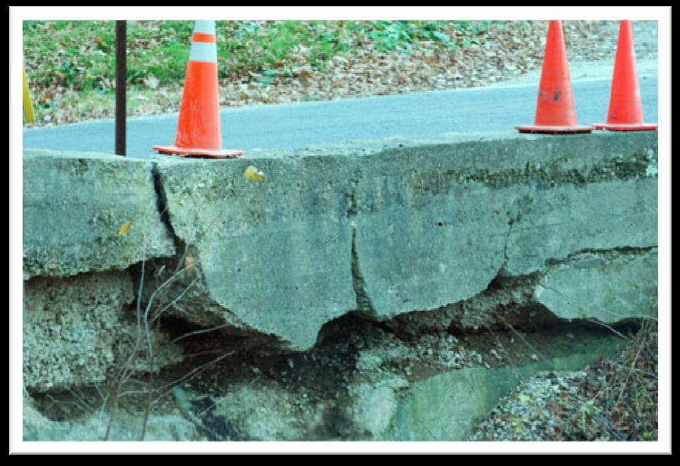

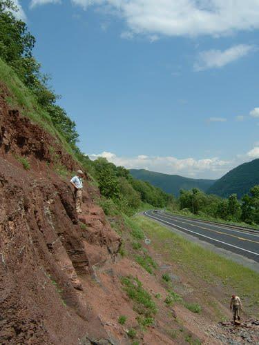
17 Roads


18 Roads

19 Pipeline clearing

20


21 During installation and after re-vegetation
22 STATE PARKS & NATURAL AREAS I. Marcellus Shale and the Eastern United States II. Visual and Experiential Impacts III. State Parks and Natural Areas IV. Crowdsourced Scenic/Visual Amenity V. Predictive Models

23

24
25
26
27

28
29 PA Nature Conservancy 2006

30 12.14 Hectares PA Nature Conservancy 2006

31 STATE PARKS & NATURAL AREAS
32 STATE PARKS & NATURAL AREAS

33 STATE PARKS & NATURAL AREAS 5% Land Use 47% 48% Forest Farmland Other
34 Hectares
35 I. Marcellus Shale and the Eastern United States II. Visual and Experiential Impacts III. State Parks and Natural Areas IV. Crowdsourced Scenic/Visual Amenity V. Predictive Models

36

37 Devil s Elbow

38 Bark Cabin


39 Miller Run


40 East Branch Swamp


41 Pine Creek Gorge Natural Area


42 Mt. Pigsah


43 Bucktail State Park
44 Well Pad Visibility

45 Well Pad Visibility
46
47

48

49

50
51 I. Marcellus Shale and the Eastern United States II. Visual and Experiential Impacts III. State Parks and Natural Areas IV. Crowdsourced Scenic/Visual Amenity V. Predictive Models

52 M A X I M U M E N T R O P Y + M A X E N T We are interested in devising a model of a species environmental requirements from a set of occurrence localities, together with a set of environmental variables that describe some of the factors that likely influence the suitability of the environment for the species. Phillips et al. 2006: 232 A niche-based model represents an approximation of a species ecological niche in the examined environmental dimensions [and] thus represents an approximation of the species realized niche (i.e., smaller than it s fundamental niche). software and articles:


53 M O D E L I N P U T S : 2009permits 2010permits 2011permits 2012permits 2013permits 2014permits allpermits depth.asc disttopipe.asc disttoroads.asc landuse.asc naturalarea.asc slope.asc thickness.asc water.asc marcellusprobability ALL MODELS WERE CROSSVALIDATED
54 HIGH PROBABILISTIC MODEL FOR FUTURE DEVELOPMENT: SUMMARIZED BY BASIN (SUB-WATERSHED)

55 HIGH PROBABILISTIC MODEL FOR FUTURE DEVELOPMENT: SUMMARIZED BY BASIN (SUB-WATERSHED)

56 L E A S T C O S T S U R FA C E M O D E L S :


57 dirt and gravel roads forested area probability streams and water bodies + = wetlands a new shape of pennsylvania? agriculture and pasture
58 T H A N K Y O U Research Supported by The Hamer Center for Community Penn State University Lacey Goldberg (Pennsylvania State University) Timothy Murtha, PhD (Pennsylvania State University)
MUG Presentation. Quantifying Habitat Disturbance by Marcellus Shale Drilling Activities in Pennsylvania. Introduction. Previous Work.
 Quantifying Habitat Disturbance by Marcellus Shale Drilling Activities in Pennsylvania Dr. Chad Freed Elisabeth Powell Widener University MUG Presentation and Problem Statement GIS Data Acquisition and
Living in a Watershed
 Living in a Watershed Department of Ecosystem Science and Ma... http://ecosystems.psu.edu/youth/sftrc/lesson-plans/water/k-5/watershed Department of Ecosystem Science and Management Youth Living in a Watershed
Map Set 3: Impact on Population
 The Potential Environmental Impacts of Full Development of the Marcellus Shale in Pennsylvania Sep 216 Map Set 3: Impact on Population This series of maps displays information related to the potential
1.0 PURPOSE AND FORMAT OF THE FINAL EIR
 1.0 PURPOSE AND FORMAT OF THE FINAL EIR 1.1 PROJECT OVERVIEW CEMEX (RMC Pacific Materials, dba CEMEX) operates the Bonny Doon Shale and Limestone Quarries in Santa Cruz County for the production of Portland
Module/Unit: Landforms Grade Level: Fifth
 Module/Unit: Landforms Grade Level: Fifth PA Academic Standards for Science and Technology and Environment and Ecology: 3.1.7.B Describe the use of models as an application or scientific or technological
Characterizing Sources of Stream Turbidity in the Marcellus Shale Gas-Well Drilling Region in Central Pennsylvania
 Characterizing Sources of Stream Turbidity in the Marcellus Shale Gas-Well Drilling Region in Central Pennsylvania Matt Bell, Rose Nash & Md. Khalequzzaman Department of Geology & Physics Lock Haven University,
HYDROLOGIC AND HYDRAULIC REPORT FOR SR. 0522, SECTION 5BN ALONG BLACKLOG CREEK CROMWELL TOWNSHIP HUNTINGDON COUNTY. Prepared for:
 HYDROLOGIC AND HYDRAULIC REPORT FOR SR. 0522, SECTION 5BN ALONG BLACKLOG CREEK CROMWELL TOWNSHIP Prepared for: KCI Technologies, Inc. Mechanicsburg, PA and Pennsylvania Department of Transportation Engineering
BISTI / DE-NA-ZIN WILDERNESS
 BISTI / DE-NA-ZIN WILDERNESS Activities: Facilities: Season / Hours: Description: Hiking and photography. No electrical hookups, water, or restrooms are available. Open year-round. The Bisti/De-Na-Zin
One Hilltop, Three Major Watersheds!
 One Hilltop, Three Major Watersheds! Adapted from: An original Creek Connections activity. Creek Connections, Box E, Allegheny College, Meadville, Pennsylvania, 16335 Watersheds of PA/ Topo Map Review
FUTURE MEANDER BEND MIGRATION AND FLOODPLAIN DEVELOPMENT PATTERNS NEAR RIVER MILES 200 TO 191 OF THE SACRAMENTO RIVER
 FUTURE MEANDER BEND MIGRATION AND FLOODPLAIN DEVELOPMENT PATTERNS NEAR RIVER MILES 200 TO 191 OF THE SACRAMENTO RIVER Eric W. Larsen University of California, Davis With the assistance of Evan Girvetz
Most people used to live like this
 Urbanization Most people used to live like this Increasingly people live like this. For the first time in history, there are now more urban residents than rural residents. Land Cover & Land Use Land cover
An Internet-based Agricultural Land Use Trends Visualization System (AgLuT)
") An Internet-based Agricultural Land Use Trends Visualization System (AgLuT) Second half yearly report 01-01-2001-06-30-2001 Prepared for Missouri Department of Natural Resources Missouri Department of
An Internet-based Agricultural Land Use Trends Visualization System (AgLuT) Second half yearly report 01-01-2001-06-30-2001 Prepared for Missouri Department of Natural Resources Missouri Department of
The Road to Data in Baltimore
 Creating a parcel level database from high resolution imagery By Austin Troy and Weiqi Zhou University of Vermont, Rubenstein School of Natural Resources State and local planning agencies are increasingly
Drilling & Developing the Marcellus Shale
 Drilling & Developing the Marcellus Shale Presented by the Independent Oil and Gas Association of Pennsylvania at the Pennsylvania State Association of Township Supervisors Annual Meeting, May 12, 2008,
List of Sites in District 2C Source Number
 List of Sites in District 2C Source Number 03-002-1...2 03-021-1...4 03-070-1...6 14-002-1...8 14-007-1...10 14-011-1...12 14-015-1...14 26-004-1...16 26-007-1...18 26-010-1...20 26-013-1...22 26-036-1...24
Distance weighted approach to modeling sediment metal concentrations in Johnson Creek Watershed, Portland Oregon. Janardan Mainali Geog593 12/07/2017
 Distance weighted approach to modeling sediment metal concentrations in Johnson Creek Watershed, Portland Oregon Janardan Mainali Geog593 12/07/2017 Distance-weighted approach to modeling sediment metal
ROAD SEDIMENT ASSESSMENT & MODELING: KOOTENAI-FISHER TMDL PLANNING AREA ROAD GIS LAYERS & SUMMARY STATISTICS
 ROAD SEDIMENT ASSESSMENT & MODELING: KOOTENAI-FISHER TMDL PLANNING AREA ROAD GIS LAYERS & SUMMARY STATISTICS Prepared by: ATKINS Water Resources Group 820 North Montana Avenue Helena, MT 59601 November
Geomorphology Of The Chilliwack River Watershed Landform Mapping At North Cascades National Park Service Complex, Washington By National Park Service
 Geomorphology Of The Chilliwack River Watershed Landform Mapping At North Cascades National Park Service Complex, Washington By National Park Service READ ONLINE Snowshed contributions to the Nooksack
California Urban and Biodiversity Analysis (CURBA) Model
 Model") California Urban and Biodiversity Analysis (CURBA) Model Presentation Overview Model Overview Urban Growth Model Policy Simulation and Evaluation Model Habitat Fragmentation Analysis Case Study: Santa
California Urban and Biodiversity Analysis (CURBA) Model Presentation Overview Model Overview Urban Growth Model Policy Simulation and Evaluation Model Habitat Fragmentation Analysis Case Study: Santa
There are many different kinds of salt, but for simplicity sake, sodium chloride (NaCl) in particular will be the topic of discussion.
 in particular will be the topic of discussion.") There are many different kinds of salt, but for simplicity sake, sodium chloride (NaCl) in particular will be the topic of discussion. NaCl comes from both natural and anthropogenic sources. Naturally
There are many different kinds of salt, but for simplicity sake, sodium chloride (NaCl) in particular will be the topic of discussion. NaCl comes from both natural and anthropogenic sources. Naturally
EEC Modification Project. Initial Draft Resource Report 10 Alternatives. 569 Brookwood Village Suite 749 Birmingham, Alabama 35209
 EEC Modification Project Initial Draft Resource Report 10 Alternatives 569 Brookwood Village Suite 749 Birmingham, Alabama 35209 April 2013 INITIAL DRAFT RESOURCE REPORT 10 - ALTERNATIVES INITIAL DRAFT
Eagle Creek Post Fire Erosion Hazard Analysis Using the WEPP Model. John Rogers & Lauren McKinney
 Eagle Creek Post Fire Erosion Hazard Analysis Using the WEPP Model John Rogers & Lauren McKinney Columbia River Gorge at Risk: Using LiDAR and GIS-based predictive modeling for regional-scale erosion susceptibility
Template for Sediment and Erosion Control Plan General Instructions. Section Instructions
 Template for Sediment and Erosion Control Plan General Instructions Introduction: Soil erosion and sediment deposition from farmlands can contribute to degraded surface water quality. Sediment delivery
Optimising rain water tank sizing and distribution patterns to benefit the downstream ecology
 Optimising rain water tank sizing and distribution patterns to benefit the downstream ecology Lachlan Guthrie and Dr Saman De Silva RMIT University - School of Civil, Environmental and Chemical Engineering
FUTURE MEANDER BEND MIGRATION AND FLOODPLAIN DEVELOPMENT PATTERNS NEAR RIVER MILES 200 TO 191 OF THE SACRAMENTO RIVER PHASE III REPORT
 FUTURE MEANDER BEND MIGRATION AND FLOODPLAIN DEVELOPMENT PATTERNS NEAR RIVER MILES 200 TO 191 OF THE SACRAMENTO RIVER PHASE III REPORT Eric W. Larsen REPORT FOR DUCKS UNLIMITED March 31, 2006-1 - Contents
Sediment and nutrient transport and storage along the urban stream corridor
 Sediment and nutrient transport and storage along the urban stream corridor Greg Noe, Cliff Hupp, Ed Schenk, Jackie Batson, Nancy Rybicki, Allen Gellis What is the role of floodplains everywhere? Noe 2013,
MAUI. Introduction - Maui ISLAND OF MAUI
 ISLAND OF MAUI MAUI Located about 30 miles NNW of the Island of Hawaiÿi, Maui is the second youngest island in the Hawaiian Chain and roughly one-fifth the size (729 square miles) of the Big Island. It
Huron Creek Watershed 2005 Land Use Map
 Huron Creek Watershed 2005 Land Use Map Created By: Linda Kersten, 12/20/06 Created For: MTU Introduction to GIS Class (FW 5550) The Huron Creek Watershed Advisory Committee Michigan Technological University,
NCTCOG Regional GIS Meeting 6-Years and Going Strong. May 15, 2018 hosted by: Tarrant County
 NCTCOG Regional GIS Meeting 6-Years and Going Strong May 15, 2018 hosted by: Tarrant County Woolpert at a Glance 1911 Founded in Dayton, Ohio 25+ Offices across the nation 800+ Global employees 25+ OFFICES
USING 3D GIS TO ASSESS ENVIRONMENTAL FLOOD HAZARDS IN MINA
 King Fahd University of Petroleum & Minerals College of Environmental Design Geographical Information system USING 3D GIS TO ASSESS ENVIRONMENTAL FLOOD HAZARDS IN MINA Prepared by : Ali AL-Zahrani OUTLINE
TSEGI WASH 50% DESIGN REPORT
 TSEGI WASH 50% DESIGN REPORT 2/28/2014 Daniel Larson, Leticia Delgado, Jessica Carnes I Table of Contents Acknowledgements... IV 1.0 Project Description... 1 1.1 Purpose... 1 Figure 1. Erosion of a Headcut...
Tax ID = ac Athens Township, Bradford County, PA. Geologic Summary
 Tax ID =9-19-62 215ac Athens Township, Bradford County, PA Geologic Summary Zaengle Geoscience LLC Don Zaengle Geologist P.O. Box 242 14 Chase St. Worcester N.Y. 12197 DISCLAIMER Information on the subject
Black Road, Tax ID = , 22.7 ac Wilmot Township, Bradford County, PA. Geologic Summary
 Black Road, Tax ID = 58-127-66, 22.7 ac Wilmot Township, Bradford County, PA Geologic Summary Zaengle Geoscience LLC Don Zaengle Geologist P.O. Box 242 14 Chase St. Worcester N.Y. 12197 DISCLAIMER Information
PRINCIPLES OF GIS. 1 Low
 PRINCIPLES OF GIS Dhubri 1 Low Water Very High Vegetation High Vegetation Medium vegetatin vegetation Sand/bars Dhubri Dr. R N Sankhua Capture Store Computer Mapping People Analyze Display Query Software
Goodlette/Pine Ridge Commercial Infill Subdistrict. Exhibit IV.B Amendment Language. Revise the FUTURE LAND USE ELEMENT
 Revise the FUTURE LAND USE ELEMENT TABLE OF CONTENTS * FUTURE LAND USE MAP SERIES * Future Land Use Map * Mixed Use & Interchange Activity Centers Maps * Properties Consistent by Policy (5.9, 5.10, 5.11,
New Land Cover & Land Use Data for the Chesapeake Bay Watershed
 New Land Cover & Land Use Data for the Chesapeake Bay Watershed Why? The Chesapeake Bay Program (CBP) partnership is in the process of improving and refining the Phase 6 suite of models used to inform
Land Cover Classification Mapping & its uses for Planning
 Land Cover Classification Mapping & its uses for Planning What is Land Cover Classification Mapping? Examples of an actual product Why use Land Cover Classification Mapping for planning? Possible uses
Assessing Michigan s Biological diversity. Michigan Natural Features Inventory MSU Extension
 Assessing Michigan s Biological diversity John Paskus,, Amy Derosier,, Edward Schools, and Helen Enander Michigan Natural Features Inventory MSU Extension Goal Provide scientifically based information
Turning landscape rambles into integrative, interdisciplinary, intergenerational field experiences
 Turning landscape rambles into integrative, interdisciplinary, intergenerational field experiences Tim Lutz LeeAnn Srogi Earth & Space Sciences West Chester University The major problems of the world are
The subject paper is being submitted for approval for publication in the annual volume entitled Geological Survey Research.
 Water Resources Division 345 Middlefield Road Menlo Park, California January 12, 1965 Memorandum To: Mr. Frank E. Clark, Chief, General Hydrology Branch Thru: Area Hydrologist PCA From: Valmore C. LaMarche
Chapter 6 Mapping and Online Tools
 Chapter 6 Mapping and Online Tools The stream site you monitor is just part of a much larger system. When analyzing stream health, it is important to take a holistic view by considering the entire watershed.
CAUSES FOR CHANGE IN STREAM-CHANNEL MORPHOLOGY
 CAUSES FOR CHANGE IN STREAM-CHANNEL MORPHOLOGY Chad A. Whaley, Department of Earth Sciences, University of South Alabama, MobileAL, 36688. E-MAIL: caw408@jaguar1.usouthal.edu The ultimate goal of this
Garlic Mustard Distribution
 Garlic Mustard Distribution Brian Adair Solye Brown Alliaria Petiolata (garlic mustard) Biennial Brought to North America as a culinary and medicinal herb (useful treating skin ulcers, throat infections,
Swift Creek Sediment Management Action Plan (SCSMAP)
") Swift Creek Sediment Management Action Plan (SCSMAP) PHASE 3 PROJECT PLAN PROPOSAL Whatcom County Public Works Department 322 N. Commercial Street, Suite 210 Bellingham, WA 98225 (360) 676-6692 June 2013
Swift Creek Sediment Management Action Plan (SCSMAP) PHASE 3 PROJECT PLAN PROPOSAL Whatcom County Public Works Department 322 N. Commercial Street, Suite 210 Bellingham, WA 98225 (360) 676-6692 June 2013
Link to USGS Phase 6 Land Use Viewer website:
 Chesapeake Bay Program Phase 6 Land Use Review Frequently Asked Questions (FAQ) Link to USGS Phase 6 Land Use Viewer website: http://chesapeake.usgs.gov/phase6/ Sections: 1. Data Review and Production
Chesapeake Bay Program s New Land Cover Map (and some other neat stuff)
") Chesapeake Bay Program s New Land Cover Map (and some other neat stuff) Cassandra Pallai Geospatial Project Manager Chesapeake Conservancy December 6, 2016 Potomac Watershed Partnership Chesapeake Conservancy
Chesapeake Bay Program s New Land Cover Map (and some other neat stuff) Cassandra Pallai Geospatial Project Manager Chesapeake Conservancy December 6, 2016 Potomac Watershed Partnership Chesapeake Conservancy
Great California Delta Trail Blueprint for Contra Costa and Solano Counties GIS AND MAPPING MEMORANDUM JULY 2010
 Great California Delta Trail Blueprint for Contra Costa and Solano Counties GIS AND MAPPING MEMORANDUM JULY 2010 {DRAFT} July 2010 Introduction Geographic Information Systems (GIS) are computer-based
Figure: 08. Proposed Lalor Paste Plant. Process Overview. Hudson Bay Mining and Smelting Co., Limited. Proposed Alteration of the Lalor Mine
 Last saved by: MAHEC (2016-12-02 ) Last Plotted: 2016-12-02 Project Management Initials: Designer: Checked: Approved: Filename: P:\60519517\900-CAD, GIS\920-929 (GIS-GRAPHICS)\H\60519517-FIG-08-0000-H-PROCESSESCOCETRATOR.DWG
Great Lakes Tributary Modeling: Canaseraga Creek Watershed
 Great Lakes Tributary Modeling: Canaseraga Creek Watershed SWAT Model Authority: Section 516(e) of WRDA 1996 US Army Corps of Engineers Canaseraga Creek Project Location - Encompasses portions of Livingston,
Drilling & Fracking a well near Grass River: Notes from an informal conversation with O.I.L. Energy
 Torch, Clam, & Bellaire Lakes www.3lakes.com Drilling & Fracking a well near Grass River: Notes from an informal conversation with O.I.L. Energy Dean Branson and Gary Knapp, June 26, 2014 Given that Michigan
Investigation of the Effect of Transportation Network on Urban Growth by Using Satellite Images and Geographic Information Systems
 Presented at the FIG Congress 2018, May 6-11, 2018 in Istanbul, Turkey Investigation of the Effect of Transportation Network on Urban Growth by Using Satellite Images and Geographic Information Systems
VHD Daily Totals. Population 14.5% change. VMT Daily Totals Suffolk 24-hour VMT. 49.3% change. 14.4% change VMT
 6.9 Suffolk 6-54 VMT Population and Travel Characteristics Population 14.5% change 2014 1,529,202 VHD Daily Totals 2014 251,060 49.3% change 2040 1,788,175 2040 374,850 VMT Daily Totals 2014 39,731,990
NAME DATE TOPOGRAPHIC MAPS. Activity 1: Topographic Map Investigation I: More Than a Road Map
 NAME DATE PARTNER(S) TOPOGRAPHIC MAPS Now you have seen how topographic maps can be generated to present the elevation of a terrain. Let s look at some topographic maps and learn how to interpret them.
Spatio-temporal models
 Spatio-temporal models Involve a least a three dimensional representation of one or more key attribute variation in planar (X-Y) space and through time. (a 4 th dimension could also be use, like Z for
Topo Map Tidbits. Adapted from: An original Creek Connections activity. Creek Connections, Box 10, Allegheny College, Meadville, Pennsylvania, 16335
 Topo Map Tidbits Adapted from: An original Creek Connections activity. Creek Connections, Box 10, Allegheny College, Meadville, Pennsylvania, 16335 Introduction to Topographic Maps Grade Level: Basic Duration:
East Branch Grand Calumet River Great Lakes Legacy Act Sediment Remediation and Restoration Project
 East Branch Grand Calumet River Great Lakes Legacy Act Sediment Remediation and Restoration Project Jointly funded by the U.S. EPA Great Lakes Legacy Act, Indiana Department of Environmental Management
A Geomorphologist's Perspective on "Natural Stream" Applications in Mine Reclamation
 A Geomorphologist's Perspective on "Natural Stream" Applications in Mine Reclamation Dr. Steve Kite, West Virginia University Department of Geology & Geography National Interactive Forum on Geomorphic
Streamflow, Sediment, and Nutrient Simulation of the Bitterroot Watershed using SWAT
 Streamflow, Sediment, and Nutrient Simulation of the Bitterroot Watershed using SWAT by Dr. Michael Van Liew Montana Department of Environmental Quality Helena, Montana, USA Site Map of SWAT Watersheds
Water Resources Challenges in Adams County, Pennsylvania
 Water Resources Challenges in Adams County, Pennsylvania Water Availability in the Upper Monocacy River Basin (Marsh, Rock, Alloway, and Toms Creeks) May 13, 2010 Cherie Schultz, Ph.D. Interstate Commission
GEOGRAPHY: PAPER II. 1. Write your examination number in the appropriate blocks provided above.
 NATIONAL SENIOR CERTIFICATE EXAMINATION NOVEMBER 2014 GEOGRAPHY: PAPER II EXAMINATION NUMBER Time: 1½ hours 100 marks PLEASE READ THE FOLLOWING INSTRUCTIONS CAREFULLY 1. Write your examination number in
Introducing GIS analysis
 1 Introducing GIS analysis GIS analysis lets you see patterns and relationships in your geographic data. The results of your analysis will give you insight into a place, help you focus your actions, or
Principals and Elements of Image Interpretation
 Principals and Elements of Image Interpretation 1 Fundamentals of Photographic Interpretation Observation and inference depend on interpreter s training, experience, bias, natural visual and analytical
3.11 Floodplains Existing Conditions
 Other stormwater control practices may be needed to mitigate water quality impacts. In addition to detention facilities, other practices such as vegetated basins/buffers, infiltration basins, and bioswales
PHILIP MILNER LANDSCAPE CONSULTANT PTY LTD 144 Allisons Road, LOWER BARRINGTON POSTAL: P.O.Box 2065, SPREYTON, 7310 TASMANIA
 PHILIP MILNER LANDSCAPE CONSULTANT PTY LTD 144 Allisons Road, LOWER BARRINGTON POSTAL: P.O.Box 2065, SPREYTON, 7310 TASMANIA Mobile: 0417 052 605 Home Phone: (03) 6492 3201 Email: philip.milner@bigpond.com
Ecological Land Cover Classification For a Natural Resources Inventory in the Kansas City Region, USA
 Ecological Land Cover Classification For a Natural Resources Inventory in the Kansas City Region, USA by Applied Ecological Services, Inc. In cooperation with the Mid-America Regional Council 600 Broadway,
SPATIAL ANALYSIS. Transformation. Cartogram Central. 14 & 15. Query, Measurement, Transformation, Descriptive Summary, Design, and Inference
 14 & 15. Query, Measurement, Transformation, Descriptive Summary, Design, and Inference Geographic Information Systems and Science SECOND EDITION Paul A. Longley, Michael F. Goodchild, David J. Maguire,
Construction Exits Rock pads
 Construction Exits Rock pads SEDIMENT CONTROL TECHNIQUE Type 1 System Sheet Flow Sandy Soils Type 2 System Concentrated Flow [1] Clayey Soils Type 3 System Supplementary Trap Dispersive Soils [1] Minor
PERCEPTION and Focus on Maps. Focus on Maps 8/29/2014. English and Dutch Maps from the 1600s and 1680 British Maps of N. Am.
 PERCEPTION English and Dutch Maps from the 600s The Nature of New York Dutch67 Prof. Anthony Grande English 67 Copyright 04 AFG 676 and 680 British Maps of N. Am. 70 and 776 4 Focus on Maps Maps are geographers
[Leveraging & Improving Neighborhood Connections] Area E Cedar Creek
![[Leveraging & Improving Neighborhood Connections] Area E Cedar Creek](/thumbs/86/93508963.jpg "[Leveraging & Improving Neighborhood Connections] Area E Cedar Creek") Community Charrette LINC Dallas [Leveraging & Improving Neighborhood Connections] Area E Cedar Creek 06.02.12 LINC Workshop Area E Area E has the unique distinction of at-grade frontage to the Trinity
Community Charrette LINC Dallas [Leveraging & Improving Neighborhood Connections] Area E Cedar Creek 06.02.12 LINC Workshop Area E Area E has the unique distinction of at-grade frontage to the Trinity
George Host and Tom Hollenhorst Natural Resources Research Institute University of Minnesota Duluth
 George Host and Tom Hollenhorst Natural Resources Research Institute University of Minnesota Duluth Marc Hershfield Minnesota Pollution Control Agency Duluth, MN St. Louis River watershed Duluth-Superior
8 th 12 th Designing a Monitoring Plan Mapping & Analysis (Activities 1 2)
") 8 th 12 th Designing a Monitoring Plan Mapping & Analysis (Activities 1 2) Objectives for All Activities - To be able to define and describe the purpose and uses of topographic maps. - To define rules
8 th 12 th Designing a Monitoring Plan Mapping & Analysis (Activities 1 2) Objectives for All Activities - To be able to define and describe the purpose and uses of topographic maps. - To define rules
Simulating the groundwater discharge to wetlands. Mukwonago Basin Example and Potential Application in Dane County
 Simulating the groundwater discharge to wetlands Mukwonago Basin Example and Potential Application in Dane County Conceptual Model Topography is major control on flow to wetlands Land Surface Water Table
PROMISED LAND STATE PARK PIKE COUNTY ANCIENT RIVERS AND AGES OF ICE
 PENNSYLVANIA TRAIL OF GEOLOGY PARK GUIDE 18 PROMISED LAND STATE PARK PIKE COUNTY ANCIENT RIVERS AND AGES OF ICE Promised Land State Park is located on a broad upland surface known as the Pocono Plateau.
Preventing New Groundwater Pollution Problems from Old Oilfield Areas. Oklahoma Corporation Commission
 Preventing New Groundwater Pollution Problems from Old Oilfield Areas Patricia Billingsley, Brownfields Manager, Oklahoma Corporation Commission Last year I presented a case study about subdivision water
Mineral Formation & Mining
 Words Worth Knowing Pluton Pegmatite Limestone Ore Mining Mineral Formation & Mining Take notes using pages 11 and 13 in your ISN all RED words must be in notes 1 How do minerals form? Magma Plutons Magma
Summary Description Municipality of Anchorage. Anchorage Coastal Resource Atlas Project
 Summary Description Municipality of Anchorage Anchorage Coastal Resource Atlas Project By: Thede Tobish, MOA Planner; and Charlie Barnwell, MOA GIS Manager Introduction Local governments often struggle
Image segmentation for wetlands inventory: data considerations and concepts
 Image segmentation for wetlands inventory: data considerations and concepts Intermountain West Joint Venture Presented by : Patrick Donnelly Spatial Ecologist Intermountain West Joint Venture Missoula,
Chapter 3 - White Oak River Subbasin Includes Bogue Sound and the Newport River
 Chapter 3 - White Oak River Subbasin 03-05-03 Includes Bogue Sound and the Newport River 3.1 Water Quality Overview Subbasin 03-05-03 at a Glance Land and Water Area (sq. mi.) Total area: 228 Land area:
Boyd's HD Map of Wharton for Garmin by Boyd Ostroff, revised 1/10/2018
 Boyd's HD Map of Wharton for Garmin by Boyd Ostroff, revised 1/10/2018 Here's a subset of the larger Map of the Pines HD formatted for use on your Garmin handheld. Unfortunately Garmin places some strict
W he natural resources of Adams
 Above: Houghton Rock, Town of Adams. Following Page: "The Hole in the Rock" on Rattlesnake Mound--both remnants of rock formed by ancient seas hundreds of millions of year5 ago. (Courtesy, H.H. Bennett
CHAPTER 7 GEOLOGY AND SOILS
 CHAPTER 7 GEOLOGY AND SOILS 7.1 General Geology of the Area Based on the Geological map compiled by Cornec (2002) the area consists of Miocene/Pleistocene deposits as seen in figure 7.1. These are geologically
Photographic Log. Photo No. 1. Date: 10/27/15. Direction Photo Taken: Southwest. Photo Taken By: JBH1
 1 Southwest 10/27/15 Looking southwest on Copper Park Lane viewing clearing and grubbing of area south of Copper Park Lane prior to excavation. 2 Southeast 10/29/15 Looking southeast at the sump and pump
SWAMP GIS: A spatial decision support system for predicting and treating stormwater runoff. Michael G. Wing 1 * and Derek Godwin
 Journal of Spatial Hydrology Vol. 11, No. 2 Fall 2011 SWAMP GIS: A spatial decision support system for predicting and treating stormwater runoff Michael G. Wing 1 * and Derek Godwin Abstract SWAMP GIS
Coyote Creek Apache County, Arizona
 Coyote Creek Apache County, Arizona Listed for sale exclusively by: Traegen Knight Headquarters West Ltd. PO BOX 1980 St. Johns, AZ 85936 Phone: (928) 524-3740, Fax: (928) 563-7004, Cell: (602) 228-3494
Applying Earth System Forecasts For Climate Change To Inform Conservation Planning Of The East African Great Lakes
 Applying Earth System Forecasts For Climate Change To Inform Conservation Planning Of The East African Great Lakes S. Asefi, D. Lawrence, P. Lawrence, A. Seimon, S. Talbot 1- University Of Virginia Department
SEARCHING FOR SEDIMENT SOURCES IN SPRING CREEK
 SEARCHING FOR SEDIMENT SOURCES IN SPRING CREEK Christopher Frederick, Department of Earth Sciences, University of South Alabama, Mobile, AL 36688. E-mail: cjf702@jaguar1.usouthal.edu. Sediment deposition
Chapter 4 French Broad River Subbasin Including the: French Broad River, Little Ivy Creek (River), Ivy Creek, California Creek and Bull Creek
, Ivy Creek, California Creek and Bull Creek") Chapter 4 French Broad River Subbasin 04-03-04 Including the: French Broad River, Little Ivy Creek (River), Ivy Creek, California Creek and Bull Creek 4.1 Subbasin Overview Subbasin 04-03-04 at a Glance
Chapter 4 French Broad River Subbasin 04-03-04 Including the: French Broad River, Little Ivy Creek (River), Ivy Creek, California Creek and Bull Creek 4.1 Subbasin Overview Subbasin 04-03-04 at a Glance
APPENDIX I - AREA PLANS
 ROUTE 37 WEST LAND USE PLAN ROUTE 37 WEST LAND USE PLAN Recent land use decisions and development trends have drawn attention to the land within the Route 37 western by-pass area between Route 50 and
Tellus Survey Frequently Asked Questions:
 Tellus Survey 2017 - Frequently Asked Questions: 1. What is Tellus? Tellus is a ground and airborne geoscience mapping programme, collecting chemical and geophysical data that will inform the management
Shallow marine facies. Outline 13: The Paleozoic World. Shallow marine and terrestrial facies
 Outline 13: The Paleozoic World Shallow marine and terrestrial facies Shallow marine facies Sea level was much higher than today during much of the Paleozoic. Shallow epicontinental seas flooded continental
annex? 2 annex? 1 3F? G? H? ?? 0? annex 57
 Numbers of flowering Frasera speciosa plants in East River Valley meadows near the Rocky Mount annual count by David Inouye. Metadata at bottom of file, last updated December 2011 Year Site # 1979 1980
Multi-scale modeling of species distributions, hydrology, & gene flow
 Multi-scale modeling of species distributions, hydrology, & gene flow Douglas R. Leasure PhD. Candidate University of Arkansas Department of Biological Sciences BIG data in GIS http://www.gap.uidaho.edu/portal/datadownload.html
PENNSYLVANIA DEPARTMENT OF TRANSPORTATION ENGINEERING DISTRICT 3-0
 PENNSYLVANIA DEPARTMENT OF TRANSPORTATION ENGINEERING DISTRICT 3-0 LYCOMING COUNTY S.R.15, SECTION C41 FINAL HYDROLOGIC AND HYDRAULIC REPORT STEAM VALLEY RUN STREAM RELOCATION DATE: June, 2006 REVISED:
Executive Summary. Water Quantity
 Executive Summary Stakeholders in the Rock-Glade Watershed have taken the initiative to proceed with watershed planning as provided by the State of Washington under the Watershed Management Act (Chapter
Laboratory Exercise #2 Introduction to Quadrangle Maps
 page - Laboratory Exercise #2 Introduction to Quadrangle Maps A. Introduction to Quadrangle Maps The United States Geological Survey has developed a nationwide series of quadrangle maps that cover small
SECTION G SEDIMENT BUDGET
 SECTION G SEDIMENT BUDGET INTRODUCTION A sediment budget has been constructed for the for the time period 1952-2000. The purpose of the sediment budget is to determine the relative importance of different
Hydrologic and Water Quality Modeling for the Missouri River Basin (MORB)
") 2016 International SWAT Conference in Beijing, China Hydrologic and Water Quality Modeling for the Missouri River Basin (MORB) Zhonglong Zhang, PhD, PE, May Wu, PhD Courtesy of USACE Outline Missouri River
2016 International SWAT Conference in Beijing, China Hydrologic and Water Quality Modeling for the Missouri River Basin (MORB) Zhonglong Zhang, PhD, PE, May Wu, PhD Courtesy of USACE Outline Missouri River
What is fracking? An information flipbook on shale and tight gas drilling and fracking
 What is fracking? An information flipbook on shale and tight gas drilling and fracking Gas drilling, Queensland What is Fracking? Fracking is a new way of getting gas out of the ground by cracking the
Roger Andy Gaines, Research Civil Engineer, PhD, P.E.
 Roger Andy Gaines, Research Civil Engineer, PhD, P.E. Research Civil Engineer/Regional Technical Specialist Memphis District August 24, 2010 Objectives Where we have been (recap of situation and what s
Crows Landing Naval Base Easement
 1 of 15 West Stanislaus Resource Conservation District Crows Landing Naval Base Easement Annual Reserve Monitoring Report Jamie McFarlin 11/112012 2 of 15 West Stanislaus Resource Conservation District