Principals and Elements of Image Interpretation
|
|
|
- Lester Jayson Flowers
- 6 years ago
- Views:
Transcription

1 Principals and Elements of Image Interpretation 1
2 Fundamentals of Photographic Interpretation Observation and inference depend on interpreter s training, experience, bias, natural visual and analytical abilities. Human visual or manual interpretation is still a dominant approach to day-to-day applications of remote sensing. Observation and understanding of the basic elements of photo interpretation are critical. Why photo/image interpretation? Aerial/Regional Perspective: Examination of the Earth from an aerial perspective allows us to identify objects, patterns, and man-land interrelationships. Remotely sensed image provides spatial terrain information. 2
3 Why photo/image interpretation? The ability to obtain a historical image record to document change: The photographs or images are valuable historical records of the spatial distribution of natural and manmade phenomena. The study of change increases our understanding about the natural and human-induced processes in the landscape. Why photo/image interpretation? Three-Dimensional Depth Perception: We can obtain a 3-dimensional view of the terrain by viewing the two images of the terrain from two slightly different vantage points at the same time. Stereoscopic analysis process provides us the information of object s height, depth, and volume. 3
4 Deriving Information from Data Heads-up digitizing - Visual interpretation and manual delineation Digital image classifications Unsupervised Supervised 4

5 Digital Image Classification? Information Extraction from Pixels 5
6 Principals and Elements of Visual Image Interpretation Fundamentals of Photographic Interpretation Photo Interpretation: The examination of aerial photographs/images for the purpose of identifying objects and judging their significance. Observation & Inference: Observation provides the raw data for interpretation. Inference is the logical process by which observation and interpretation are made. 6
7 Photo interpretation Observation - Inference Where to draw the line? 7
8 Image interpretation for Land Use Mapping Guiding Principal USGS Land Use and Land Cover Classification System Anderson, J. R., E. E. Hardy, and J. T. Roach, A Land Use and Land Cover Classification System for Use with Remote Sensor Data, Washington, DC: U.S. Geological Survey Profession Paper 964, 28 pp. 8
9 USGS Land Use and Land Cover Classification System Level I 1 Urban or built-up land Level II 11 Residential 12 Commercial and Services 13 Industrial 14 Transportation, Communications, and Utilities 15 Industrial and Commercial Complexes 16 Mixed urban or Built-up land 17 Other Urban or Built-up Land USGS Land Use and Land Cover Classification System Level I 2 Agricultural land Level II 21 Cropland and pasture 22 Orchards, groves, vineyards, nurseries, and ornamental horticultural areas 23 Confined feeding operations 24 Other agricultural land 9
10 USGS Land Use and Land Cover Classification System Level I 3 Rangeland 4 Forest land Level II 31 Herbaceous rangeland 32 Shrub and brush rangeland 33 Mixed rangeland 41 Deciduous forest land 42 Evergreen forest land 43 Mixed forest land USGS Land Use and Land Cover Classification System Level I 5 Water 6 Wetland Level II 51 Streams and canals 52 Lakes 53 Reservoirs 54 Bays and estuaries 61 Forested wetland 62 Nonforested wetland 10
11 USGS Land Use and Land Cover Classification System Level I 7 Barren land Level II 71 Dry salt flats 72 Beaches 73 Sandy areas other than beaches 74 Bare exposed rock 75 Strip mines, Quarries, and gravel pits 76 Transitional areas 77 Mixed barren land Example of Sub-categorization of Residential Land (Level III) Level I Level II Level III 1. Urban or Built-up 1.1. Residential Single-family Units Multi-family Units Group Quarters Residential Hotels Mobile Home Parks Transient Lodgings Other 11
12 Representative Image Interpretation Formats for Various Land Use/Land Cover Classification Levels Land Use/Land Cover Classification Level I II III IV Representative Format for Image Interpretation Low to moderate resolution satellite data (e.g., Landsat MSS) Small-scale aerial photographs; moderate resolution satellite data (e.g., Landsat TM) Medium-scale aerial photographs; high resolution satellite data (e.g., IKONOS) Large-scale aerial photographs Elements of Image Interpretation x,y Location Size Shape Shadow Tone/Color Texture Pattern Height/Depth Site (elevation, slope, aspect) Situation Association 12
 small, medium (intermediate), large Shape An object s geometric characteristics: linear, curvilinear, circular,")

13 Elements of Image Interpretation Element x,y location Common Adjectives (Quantitative and qualitative) x,y coordinate: longitude and latitude or meters easting and northing in a UTM map grid Size Length, width, perimeter, area (m 2 ) small, medium (intermediate), large Shape An object s geometric characteristics: linear, curvilinear, circular, elliptical, radial, square, rectangular, triangular, hexagonal, pentagonal, star, amorphous, etc. The size of an object is one of the most distinguishing characteristics and one of the most important elements of image interpretation. Many natural and man-made features on the ground have very unique shapes that can be referenced in photo and image interpretation. 13
, dark (black) Color: HIS = intensity, hue (color), saturation; RGB = red, green, blue Characteristic placement of objects on the ground: systematic, random, linear, curvilinear,")

14 Elements of Image Interpretation Element Shadow Tone/color Texture Pattern Common Adjectives (Quantitative and qualitative) Caused by solar illumination from the side Gray tone: light (bright), intermediate (gray), dark (black) Color: HIS = intensity, hue (color), saturation; RGB = red, green, blue Characteristic placement of objects on the ground: systematic, random, linear, curvilinear, rectangular, circular, etc. Spatial arrangement of objects on the ground: systematic, random, linear, curvilinear, rectangular, circular, etc. The shadow in the image provides real clue to an object s identification, e.g., height. The ability to visually appreciate or measure the height (elevation) or depth (bathymetry) of an object or landform is one of the most diagnostic elements of image interpretation. 14


15 The electromagnetic radiation (EMR) recorded by remote sensing system can be displayed in shades of gray ranging from black to white tone. We may use additive color-combining techniques to create color composite images. Gray Tone Pseudo Color Image Texture is the characteristic placement and arrangement of repetitions of tones or color in an image. Pattern is the spatial arrangement of objects in the landscape. Both texture and pattern are scale independent. Texture Pattern 15
, slope o, aspect o Site: elevation, slope, aspect, exposure, adjacency to water, transportation, utilities Situation: objects are placed in a particular order or orientation relative to")
16 Elements of Image Interpretation Element Height/depth Volume/ slope/aspect Site/ situation/ association Common Adjectives (Quantitative and qualitative) z-elevation (height), depth (bathymetry), volume (m 3 ), slope o, aspect o Site: elevation, slope, aspect, exposure, adjacency to water, transportation, utilities Situation: objects are placed in a particular order or orientation relative to one another Association: related phenomena are usually present Site, situation, and association characteristics are very important when trying to identify an object or activity. They are always used together. Site: - physical (elevation, slope, aspect, type of surface cover) - socioeconomic (value of the land, adjacency to water) Situation: How objects are organized and oriented relative to one another. Association: When you find a certain activity or phenomena, you almost invariably encounter related or associated features or activities. 16
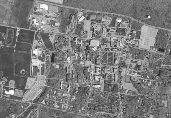
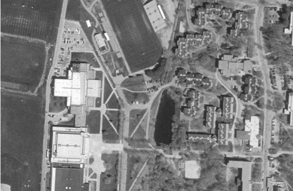
17 Where to draw the line? Delineation of polygons and placement of labels 17

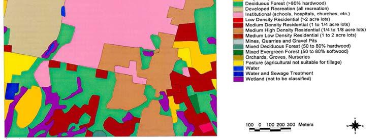
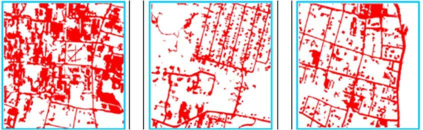
18 The Photo-Overlay Left: aerial photograph Right: land cover boundaries as interpreted from the photographs; numbers corresponded to Anderson Level II classification system. The delineation of a land use polygon includes the entire area devoted to a particular use. In this example the entire area inside the boundaries of an airfield is represented on the land use map as a single polygon, even though it is composed of several recognizable components. 18
19 19
20 Land-Use Map Land-Cover Map The use of land by humans, usually with emphasis on the functional role of land in economic activities Land use forms an abstraction, not always directly observable even by a closest inspection ABSTRACT Designates the visible evidence of land use features. Directly observable physical or biophysical cover on the earth s surface CONCRETE The definition establishes a direct link between land cover and the actions of people in their environment. 20
 Urban")


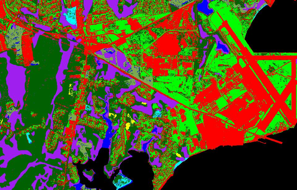
21 An Example of Land-Use Map vs. Land Cover Map (e.g., Extracted Impervious Surface Areas) Urban Pasture/Cropland Forest/Woodland Brushland Water Wetland Openland Urban Grass Quonset State Airport Narragansett Bay An Example of Land-Use Map vs. Land Cover Map (e.g., Extracted Impervious Surface Areas) Urban Pasture/Cropland Forest/Woodland Brushland Water Wetland Openland Urban Grass 21


22 Use of color as symbols for land use classes by USGS system Level I Category Symbol Color Urban/Built-up Land 1 Red Agricultural Land 2 Light Brown Rangeland 3 Light Orange Forest Land 4 Green Water 5 Dark Blue Wetland 6 Light Blue Barren Land 7 Gray Tundra 8 Green-Gray Perennial Snow or Ice 9 White Oblique aerial photograph Vertical aerial photograph Measurable information 22
Fundamentals of Photographic Interpretation
 Principals and Elements of Image Interpretation Fundamentals of Photographic Interpretation Observation and inference depend on interpreter s training, experience, bias, natural visual and analytical abilities.
An Internet-based Agricultural Land Use Trends Visualization System (AgLuT)
") An Internet-based Agricultural Land Use Trends Visualization System (AgLuT) Second half yearly report 01-01-2001-06-30-2001 Prepared for Missouri Department of Natural Resources Missouri Department of
An Internet-based Agricultural Land Use Trends Visualization System (AgLuT) Second half yearly report 01-01-2001-06-30-2001 Prepared for Missouri Department of Natural Resources Missouri Department of
Managing uncertainty when aggregating from pixels to parcels: context sensitive mapping and possibility theory
 Department of Geography Managing uncertainty when aggregating from pixels to parcels: context sensitive mapping and possibility theory Dr Lex Comber ajc36@le.ac.uk www.le.ac.uk/gg/staff/academic_comber.htm
Los Alamos National Laboratory is operated by the University of California for the United States Department of Energy under contract W-7405-ENG-36.
 LA-UR-01-4549 Los Alamos National Laboratory is operated by the University of California for the United States Department of Energy under contract W-7405-ENG-36. TITLE: Evaluation of Land Use/Land Cover
Fri. Apr. 20, Today: Review briefly Ch. 11 (Mineral Exploration) Summarize Ch Land use classification
 Summarize Ch Land use classification") Fri. Apr. 20, 2018 Today: Review briefly Ch. 11 (Mineral Exploration) Summarize Ch. 12 -- Land use classification Reading: Skim Sabins Chapter 12 -- Land Use Concept of multi-level classification important
Fri. Apr. 20, 2018 Today: Review briefly Ch. 11 (Mineral Exploration) Summarize Ch. 12 -- Land use classification Reading: Skim Sabins Chapter 12 -- Land Use Concept of multi-level classification important
2011 Land Use/Land Cover Delineation. Meghan Jenkins, GIS Analyst, GISP Jennifer Kinzer, GIS Coordinator, GISP
 2011 Land Use/Land Cover Delineation Meghan Jenkins, GIS Analyst, GISP Jennifer Kinzer, GIS Coordinator, GISP History O Key Points O Based on Anderson s Land Use and Land Cover Classification System O
An Internet-based Agricultural Land Use Trends Visualization System (AgLuT)
") An Internet-based Agricultural Land Use Trends Visualization System (AgLuT) Prepared for Missouri Department of Natural Resources Missouri Department of Conservation 07-01-2000-12-31-2001 Submitted by
An Internet-based Agricultural Land Use Trends Visualization System (AgLuT) Prepared for Missouri Department of Natural Resources Missouri Department of Conservation 07-01-2000-12-31-2001 Submitted by
IMPROVING REMOTE SENSING-DERIVED LAND USE/LAND COVER CLASSIFICATION WITH THE AID OF SPATIAL INFORMATION
 IMPROVING REMOTE SENSING-DERIVED LAND USE/LAND COVER CLASSIFICATION WITH THE AID OF SPATIAL INFORMATION Yingchun Zhou1, Sunil Narumalani1, Dennis E. Jelinski2 Department of Geography, University of Nebraska,
Criteria for Selection of Land Use/Cover Data for Urban Stormwater Quality Analysis
 Contract Report 548 Criteria for Selection of Land Use/Cover Data for Urban Stormwater Quality Analysis by Ming T. Lee, Ying Ke, and Michael L. Terstriep Office of Surface Water Information and GIS Prepared
PRINCIPLES OF PHOTO INTERPRETATION
 PRINCIPLES OF PHOTO INTERPRETATION Photo Interpretation the act of examining photographic images for the purpose of identifying objects and judging their significance an art more than a science Recognition
The Road to Data in Baltimore
 Creating a parcel level database from high resolution imagery By Austin Troy and Weiqi Zhou University of Vermont, Rubenstein School of Natural Resources State and local planning agencies are increasingly
GIS in Action. Nature (453, 2,1 May 2008) Application issues. Understanding GIS by Case Study. Getting Started With GIS Chapter 10
 Application issues. Understanding GIS by Case Study. Getting Started With GIS Chapter 10") Nature (453, 2,1 May 2008) GIS in Action Getting Started With GIS Chapter 10 Understanding GIS by Case Study Use of GIS is best understood by examining case studies. Case studies in 4ed chapter cover rural,
Nature (453, 2,1 May 2008) GIS in Action Getting Started With GIS Chapter 10 Understanding GIS by Case Study Use of GIS is best understood by examining case studies. Case studies in 4ed chapter cover rural,
Urban Growth Analysis: Calculating Metrics to Quantify Urban Sprawl
 Urban Growth Analysis: Calculating Metrics to Quantify Urban Sprawl Jason Parent jason.parent@uconn.edu Academic Assistant GIS Analyst Daniel Civco Professor of Geomatics Center for Land Use Education
Remote Sensing the Urban Landscape
 Remote Sensing the Urban Landscape Urban landscape are composed of a diverse assemblage of materials (concrete, asphalt, metal, plastic, shingles, glass, water, grass, shrubbery, trees, and soil) arranged
7.1 INTRODUCTION 7.2 OBJECTIVE
 7 LAND USE AND LAND COVER 7.1 INTRODUCTION The knowledge of land use and land cover is important for many planning and management activities as it is considered as an essential element for modeling and
BIODIVERSITY CONSERVATION HABITAT ANALYSIS
 BIODIVERSITY CONSERVATION HABITAT ANALYSIS A GIS Comparison of Greater Vancouver Regional Habitat Mapping with Township of Langley Local Habitat Mapping Preface This report was made possible through the
Abstract: About the Author:
 REMOTE SENSING AND GIS IN LAND USE PLANNING Sathees kumar P 1, Nisha Radhakrishnan 2 1 1 Ph.D Research Scholar, Department of Civil Engineering, National Institute of Technology, Tiruchirappalli- 620015,
Southern California Earthquake Center
 Southern California Earthquake Center By: Mark Slothower Geog 406 Final Report Dr. Sun Table of Contents Introduction Page 3 Hypothesis and research questions Page 3 Methods and flowchart Page 4 Data Page
International Journal of Intellectual Advancements and Research in Engineering Computations
 ISSN:2348-2079 Volume-5 Issue-2 International Journal of Intellectual Advancements and Research in Engineering Computations Agricultural land investigation and change detection in Coimbatore district by
Quick Response Report #126 Hurricane Floyd Flood Mapping Integrating Landsat 7 TM Satellite Imagery and DEM Data
 Quick Response Report #126 Hurricane Floyd Flood Mapping Integrating Landsat 7 TM Satellite Imagery and DEM Data Jeffrey D. Colby Yong Wang Karen Mulcahy Department of Geography East Carolina University
PROANA A USEFUL SOFTWARE FOR TERRAIN ANALYSIS AND GEOENVIRONMENTAL APPLICATIONS STUDY CASE ON THE GEODYNAMIC EVOLUTION OF ARGOLIS PENINSULA, GREECE.
 PROANA A USEFUL SOFTWARE FOR TERRAIN ANALYSIS AND GEOENVIRONMENTAL APPLICATIONS STUDY CASE ON THE GEODYNAMIC EVOLUTION OF ARGOLIS PENINSULA, GREECE. Spyridoula Vassilopoulou * Institute of Cartography
PRELIMINARY DRAFT 12/21/2007. APPENDIX C Comparison of Climatology and Land Use for Surface Air Met Station Data
 PRELIMINARY DRAFT 12/21/2007 APPENDIX C Comparison of Climatology and Land Use for Surface Air Met Station Data APPENDIX C Comparison of Climatology/Meteorology and Land Use/Cover for Surface Air Met Station
INTERNATIONAL JOURNAL OF GEOMATICS AND GEOSCIENCES Volume 6, No 2, 2015
 INTERNATIONAL JOURNAL OF GEOMATICS AND GEOSCIENCES Volume 6, No 2, 2015 Copyright by the authors - Licensee IPA- Under Creative Commons license 3.0 Research article ISSN 0976 4380 An Analysis of Land use
Dr.N.Chandrasekar Professor and Head Centre for GeoTechnology Manonmaniam Sundaranar University Tirunelveli
 Classification and Segmentation of Coastal Landforms in the South Tamilnadu Coast Dr.N.Chandrasekar Professor and Head Centre for GeoTechnology Manonmaniam Sundaranar University Tirunelveli E-mail: profncsekar@gmail.com
Huron Creek Watershed 2005 Land Use Map
 Huron Creek Watershed 2005 Land Use Map Created By: Linda Kersten, 12/20/06 Created For: MTU Introduction to GIS Class (FW 5550) The Huron Creek Watershed Advisory Committee Michigan Technological University,
Changes in Seasonal Albedo with Land Cover Class
 Name: Date: Changes in Seasonal Albedo with Land Cover Class Guiding question: How does albedo change over the seasons in different land cover classes? Introduction. Now that you have completed the Introduction
International Journal of Scientific & Engineering Research, Volume 6, Issue 7, July ISSN
 International Journal of Scientific & Engineering Research, Volume 6, Issue 7, July-2015 1428 Accuracy Assessment of Land Cover /Land Use Mapping Using Medium Resolution Satellite Imagery Paliwal M.C &.
LAND COVER CATEGORY DEFINITION BY IMAGE INVARIANTS FOR AUTOMATED CLASSIFICATION
 LAND COVER CATEGORY DEFINITION BY IMAGE INVARIANTS FOR AUTOMATED CLASSIFICATION Nguyen Dinh Duong Environmental Remote Sensing Laboratory Institute of Geography Hoang Quoc Viet Rd., Cau Giay, Hanoi, Vietnam
Environmental Impact Assessment Land Use and Land Cover CISMHE 7.1 INTRODUCTION
 7 LAND USE AND LAND COVER 7.1 INTRODUCTION The knowledge of land use and land cover is important for many planning and management activities as it is considered an essential element for modeling and understanding
Mapping Earth. Technology and Mapmaking
 CHAPTER 1 LESSON 2 Mapping Earth Technology and Mapmaking Key Concepts What can a topographic map tell you about the shape of Earth s surface? What can you learn from geologic maps about the rocks near
Mapping Soils, Crops, and Rangelands by Machine Analysis of Multi-Temporal ERTS-1 Data
 Purdue University Purdue e-pubs LARS Technical Reports Laboratory for Applications of Remote Sensing 1-1-1973 Mapping Soils, Crops, and Rangelands by Machine Analysis of Multi-Temporal ERTS-1 Data M. F.
B. Topographic maps are also called. contour maps
 Topographic Maps Introduction A. Topographic maps are essential tools in geologic and engineering studies because they show the configuration of Earth's surface in remarkable detail and permit one to measure
USING THE MILITARY LENSATIC COMPASS
 USING THE MILITARY LENSATIC COMPASS WARNING This presentation is intended as a quick summary, and not a comprehensive resource. If you want to learn Land Navigation in detail, either buy a book; or get
Review Using the Geographical Information System and Remote Sensing Techniques for Soil Erosion Assessment
 Polish J. of Environ. Stud. Vol. 19, No. 5 (2010), 881-886 Review Using the Geographical Information System and Remote Sensing Techniques for Soil Erosion Assessment Nuket Benzer* Landscape Architecture
Object Based Imagery Exploration with. Outline
 Object Based Imagery Exploration with Dan Craver Portland State University June 11, 2007 Outline Overview Getting Started Processing and Derivatives Object-oriented classification Literature review Demo
CHANGES IN VIJAYAWADA CITY BY REMOTE SENSING AND GIS
 International Journal of Civil Engineering and Technology (IJCIET) Volume 8, Issue 5, May 2017, pp.217 223, Article ID: IJCIET_08_05_025 Available online at http://www.ia aeme.com/ijciet/issues.asp?jtype=ijciet&vtyp
MARYLAND S LAND USE/LAND COVER MAP AND ASSOCIATED ANALYSIS
 MARYLAND S LAND USE/LAND COVER MAP AND ASSOCIATED ANALYSIS Maryland Department of Planning Daniel Baldwin Stephanie Martins November 19, 2012 http://www.planning.maryland.gov/ PURPOSE The primary purpose
Topo Map Tidbits. Adapted from: An original Creek Connections activity. Creek Connections, Box 10, Allegheny College, Meadville, Pennsylvania, 16335
 Topo Map Tidbits Adapted from: An original Creek Connections activity. Creek Connections, Box 10, Allegheny College, Meadville, Pennsylvania, 16335 Introduction to Topographic Maps Grade Level: Basic Duration:
Custom Soil Resource Report for Victoria County, Texas
 United States Department of Agriculture Natural Resources Conservation Service A product of the National Cooperative Soil Survey, a joint effort of the United States Department of Agriculture and other
Lesson 4b Remote Sensing and geospatial analysis to integrate observations over larger scales
 Lesson 4b Remote Sensing and geospatial analysis to integrate observations over larger scales We have discussed static sensors, human-based (participatory) sensing, and mobile sensing Remote sensing: Satellite
New Land Cover & Land Use Data for the Chesapeake Bay Watershed
 New Land Cover & Land Use Data for the Chesapeake Bay Watershed Why? The Chesapeake Bay Program (CBP) partnership is in the process of improving and refining the Phase 6 suite of models used to inform
INVESTIGATION LAND USE CHANGES IN MEGACITY ISTANBUL BETWEEN THE YEARS BY USING DIFFERENT TYPES OF SPATIAL DATA
 INVESTIGATION LAND USE CHANGES IN MEGACITY ISTANBUL BETWEEN THE YEARS 1903-2010 BY USING DIFFERENT TYPES OF SPATIAL DATA T. Murat Celikoyan, Elif Sertel, Dursun Zafer Seker, Sinasi Kaya, Uğur Alganci ITU,
5.3 MICROSCALE MODELING NEEDS FOR DIGITIZED SURFACE FEATURE MORPHOLOGY URBAN AND RURAL
 5.3 MICROSCALE MODELING NEEDS FOR DIGITIZED SURFACE FEATURE MORPHOLOGY URBAN AND RURAL Ronald M. Cionco US Army Research Laboratory White Sands Missile Range, NM 88002 1. INTRODUCTION The most recent report
STUDY OF NORMALIZED DIFFERENCE BUILT-UP (NDBI) INDEX IN AUTOMATICALLY MAPPING URBAN AREAS FROM LANDSAT TM IMAGERY
 INDEX IN AUTOMATICALLY MAPPING URBAN AREAS FROM LANDSAT TM IMAGERY") STUDY OF NORMALIZED DIFFERENCE BUILT-UP (NDBI) INDEX IN AUTOMATICALLY MAPPING URBAN AREAS FROM LANDSAT TM IMAGERY Dr. Hari Krishna Karanam Professor, Civil Engineering, Dadi Institute of Engineering &
STUDY OF NORMALIZED DIFFERENCE BUILT-UP (NDBI) INDEX IN AUTOMATICALLY MAPPING URBAN AREAS FROM LANDSAT TM IMAGERY Dr. Hari Krishna Karanam Professor, Civil Engineering, Dadi Institute of Engineering &
URBAN LAND COVER AND LAND USE CLASSIFICATION USING HIGH SPATIAL RESOLUTION IMAGES AND SPATIAL METRICS
 URBAN LAND COVER AND LAND USE CLASSIFICATION USING HIGH SPATIAL RESOLUTION IMAGES AND SPATIAL METRICS Ivan Lizarazo Universidad Distrital, Department of Cadastral Engineering, Bogota, Colombia; ilizarazo@udistrital.edu.co
Lecture 9: Reference Maps & Aerial Photography
 Lecture 9: Reference Maps & Aerial Photography I. Overview of Reference and Topographic Maps There are two basic types of maps? Reference Maps - General purpose maps & Thematic Maps - maps made for a specific
Canada Land Inventory (CLI) CANADA LAND INVENTORY LEVEL-I LAT/LONG DIGITAL DATA LAND CAPABILITY FOR RECREATION. 1.0 Coverage Specifications
 CANADA LAND INVENTORY LEVEL-I LAT/LONG DIGITAL DATA LAND CAPABILITY FOR RECREATION. 1.0 Coverage Specifications") Canada Land Inventory (CLI) CANADA LAND INVENTORY LEVEL-I LAT/LONG DIGITAL DATA LAND CAPABILITY FOR RECREATION 1.0 Coverage Specifications Original Map Scale: 1:250,000 Resolution :.00024414 of a degree
Canada Land Inventory (CLI) CANADA LAND INVENTORY LEVEL-I LAT/LONG DIGITAL DATA LAND CAPABILITY FOR RECREATION 1.0 Coverage Specifications Original Map Scale: 1:250,000 Resolution :.00024414 of a degree
Delineation of high landslide risk areas as a result of land cover, slope, and geology in San Mateo County, California
 Delineation of high landslide risk areas as a result of land cover, slope, and geology in San Mateo County, California Introduction Problem Overview This project attempts to delineate the high-risk areas
Lab Topographic Maps. Name: Partner: Purpose. Background Information
 Lab Topographic Maps Name: Partner: Purpose The purpose of this lab is to familiarize you with graphic representations of the Earth s surface primarily maps. Simple line maps show the spatial relationship
Land Use/Land Cover Mapping in and around South Chennai Using Remote Sensing and GIS Techniques ABSTRACT
 Land Use/Land Cover Mapping in and around South Chennai Using Remote Sensing and GIS Techniques *K. Ilayaraja, Abhishek Singh, Dhiraj Jha, Kriezo Kiso, Amson Bharath institute of Science and Technology
Investigation of the Effect of Transportation Network on Urban Growth by Using Satellite Images and Geographic Information Systems
 Presented at the FIG Congress 2018, May 6-11, 2018 in Istanbul, Turkey Investigation of the Effect of Transportation Network on Urban Growth by Using Satellite Images and Geographic Information Systems
CRUM RANCH AREA MAP YOLO COUNTY, California, AC +/-
 CRUM RANCH AREA MAP YOLO COUNTY, California, 235.59 AC +/- Map data 2016 Google Imagery 2016, CAPCOG, DigitalGlobe, Texas Orthoimagery Program, U.S. Geological Survey, USDA Farm Service Agency Boundary
Photographs to Maps Using Aerial Photographs to Create Land Cover Maps
 Aerial photographs are an important source of information for maps, especially land cover and land use maps. Using ArcView, a map composed of points, lines, and areas (vector data) can be constructed from
Module 2.1 Monitoring activity data for forests using remote sensing
 Module 2.1 Monitoring activity data for forests using remote sensing Module developers: Frédéric Achard, European Commission (EC) Joint Research Centre (JRC) Jukka Miettinen, EC JRC Brice Mora, Wageningen
Mapping Earth. How are Earth s surface features measured and modeled?
 Name Mapping Earth How are Earth s surface features measured and modeled? Before You Read Before you read the chapter, think about what you know about maps Record your thoughts in the first column Pair
DETECTION AND ANALYSIS OF LAND-USE/LAND-COVER CHANGES IN NAY PYI TAW, MYANMAR USING SATELLITE REMOTE SENSING IMAGES
 DETECTION AND ANALYSIS OF LAND-USE/LAND-COVER CHANGES IN NAY PYI TAW, MYANMAR USING SATELLITE REMOTE SENSING IMAGES Kay Khaing Oo 1, Eiji Nawata 1, Kiyoshi Torii 2 and Ke-Sheng Cheng 3 1 Division of Environmental
AGOG 485/585 /APLN 533 Spring Lecture 5: MODIS land cover product (MCD12Q1). Additional sources of MODIS data
. Additional sources of MODIS data") AGOG 485/585 /APLN 533 Spring 2019 Lecture 5: MODIS land cover product (MCD12Q1). Additional sources of MODIS data Outline Current status of land cover products Overview of the MCD12Q1 algorithm Mapping
AGOG 485/585 /APLN 533 Spring 2019 Lecture 5: MODIS land cover product (MCD12Q1). Additional sources of MODIS data Outline Current status of land cover products Overview of the MCD12Q1 algorithm Mapping
This is trial version
 Journal of Rangeland Science, 2012, Vol. 2, No. 2 J. Barkhordari and T. Vardanian/ 459 Contents available at ISC and SID Journal homepage: www.rangeland.ir Full Paper Article: Using Post-Classification
Land cover/land use mapping and cha Mongolian plateau using remote sens. Title. Author(s) Bagan, Hasi; Yamagata, Yoshiki. Citation Japan.
 Bagan, Hasi; Yamagata, Yoshiki. Citation Japan.") Title Land cover/land use mapping and cha Mongolian plateau using remote sens Author(s) Bagan, Hasi; Yamagata, Yoshiki International Symposium on "The Imp Citation Region Specific Systems". 6 Nove Japan.
Title Land cover/land use mapping and cha Mongolian plateau using remote sens Author(s) Bagan, Hasi; Yamagata, Yoshiki International Symposium on "The Imp Citation Region Specific Systems". 6 Nove Japan.
Looking at Communities: Comparing Urban and Rural Neighborhoods
 Looking at Communities: Comparing Urban and Rural Neighborhoods OVERVIEW & OBJECTIVES Our urban areas have become so dominant that frequently the children we teach have no connection with and very few
ESTIMATION OF LANDFORM CLASSIFICATION BASED ON LAND USE AND ITS CHANGE - Use of Object-based Classification and Altitude Data -
 ESTIMATION OF LANDFORM CLASSIFICATION BASED ON LAND USE AND ITS CHANGE - Use of Object-based Classification and Altitude Data - Shoichi NAKAI 1 and Jaegyu BAE 2 1 Professor, Chiba University, Chiba, Japan.
Lesson Plan 3 Land Cover Changes Over Time. An Introduction to Land Cover Changes over Time
 An Introduction to Land Cover Changes over Time This lesson plan builds on the lesson plan on Understanding Land Use and Land Cover Using Google Earth. Please refer to it in terms of definitions on land
Unit 1, Lesson 3 What Tools and Technologies Do Geographers Use?
 Unit 1, Lesson 3 What Tools and Technologies Do Geographers Use? Geographers use a variety of tools and technologies in investigating geographic questions. Maps and globes both represent the earth, but
UNIT 1C. USING TOPOGRAPHIC MAPS WHERE IN THE WORLD... ARE YOU?
 UNIT 1C. USING TOPOGRAPHIC MAPS WHERE IN THE WORLD... ARE YOU? TIME 60-90 minutes LEVEL All BENCHMARKS Next Generation Science Standards MS-LS1.D Science & Engineering Practices Developing and Using Models
NAVAJO NATION PROFILE
 NAVAJO NATION PROFILE Largest land based area and federally recognized tribe in the United States Over 27,000 square miles (or 17.2 million acres with a population of over 300,000 people. Covers Arizona,
DEPENDENCE OF URBAN TEMPERATURE ELEVATION ON LAND COVER TYPES. Ping CHEN, Soo Chin LIEW and Leong Keong KWOH
 DEPENDENCE OF URBAN TEMPERATURE ELEVATION ON LAND COVER TYPES Ping CHEN, Soo Chin LIEW and Leong Keong KWOH Centre for Remote Imaging, Sensing and Processing, National University of Singapore, Lower Kent
LAND USE/LAND COVER CLASSIFICATION AND ACCURACY ASSESSMENT USING SATELLITE DATA - A CASE STUDY OF BHIND DISTRICT, MADHYA PRADESH
 , pp.-422-426. Available online at http://www.bioinfopublication.org/jouarchive.php?opt=&jouid=bpj0000217 LAND USE/LAND COVER CLASSIFICATION AND ACCURACY ASSESSMENT USING SATELLITE DATA - A CASE STUDY
DIFFERENTIATING A SMALL URBAN AREA FROM OTHER LAND COVER CLASSES EMPLOYING LANDSAT MSS
 DIFFERENTIATING A SMALL URBAN AREA FROM OTHER LAND COVER CLASSES EMPLOYING LANDSAT MSS Lon Arowesty Department of Geography SUNY-College at Oneonta Oneonta, New York 13820 For over a decade, Landsat data
Urban Tree Canopy Assessment Purcellville, Virginia
 GLOBAL ECOSYSTEM CENTER www.systemecology.org Urban Tree Canopy Assessment Purcellville, Virginia Table of Contents 1. Project Background 2. Project Goal 3. Assessment Procedure 4. Economic Benefits 5.
Different types of maps and how to read them.
 Different types of maps and how to read them. A map is a picture or representation of the Earth's surface, showing how things are related to each other by distance, direction, and size. Maps have been
LAND USE, LAND COVER AND SOIL SCIENCES - Vol. I - Land Use and Land Cover, Including their Classification - Duhamel C.
 LAND USE AND LAND COVER, INCLUDING THEIR CLASSIFICATION Duhamel Landsis Groupement Européen d Intérêt Economique, Luxembourg Keywords: land cover, land use, classification systems, nomenclature, information
Trimble s ecognition Product Suite
 Trimble s ecognition Product Suite Dr. Waldemar Krebs October 2010 Trimble Geospatial in the Image Processing Chain Data Acquisition Pre-processing Manual/Pixel-based Object-/contextbased Interpretation
Vegetation Change Detection of Central part of Nepal using Landsat TM
 Vegetation Change Detection of Central part of Nepal using Landsat TM Kalpana G. Bastakoti Department of Geography, University of Calgary, kalpanagb@gmail.com Abstract This paper presents a study of detecting
Monitoring Vegetation Growth of Spectrally Landsat Satellite Imagery ETM+ 7 & TM 5 for Western Region of Iraq by Using Remote Sensing Techniques.
 Monitoring Vegetation Growth of Spectrally Landsat Satellite Imagery ETM+ 7 & TM 5 for Western Region of Iraq by Using Remote Sensing Techniques. Fouad K. Mashee, Ahmed A. Zaeen & Gheidaa S. Hadi Remote
2015 KANSAS LAND COVER PATTERNS PHASE I - FINAL REPORT
 2015 KANSAS LAND COVER PATTERNS PHASE I - FINAL REPORT Kansas Applied Remote Sensing Program Kansas Biological Survey University of Kansas Lawrence, Kansas 66047 January 13, 2017 Report Prepared by: Dana
An Introduction to Geographic Information System
 An Introduction to Geographic Information System PROF. Dr. Yuji MURAYAMA Khun Kyaw Aung Hein 1 July 21,2010 GIS: A Formal Definition A system for capturing, storing, checking, Integrating, manipulating,
Unit 1, Lesson 2. What is geographic inquiry?
 What is geographic inquiry? Unit 1, Lesson 2 Understanding the way in which social scientists investigate problems will help you conduct your own investigations about problems or issues facing your community
CHAPTER 1 THE UNITED STATES 2001 NATIONAL LAND COVER DATABASE
 CHAPTER 1 THE UNITED STATES 2001 NATIONAL LAND COVER DATABASE Collin Homer*, Jon Dewitz, Joyce Fry, and Nazmul Hossain *U.S. Geological Survey (USGS) Center for Earth Resources Observation and Science
History & Scope of Remote Sensing FOUNDATIONS
 History & Scope of Remote Sensing FOUNDATIONS Lecture Overview Introduction Overview of visual information Power of imagery Definition What is remote sensing? Definition standard for class History of Remote
Yanbo Huang and Guy Fipps, P.E. 2. August 25, 2006
 Landsat Satellite Multi-Spectral Image Classification of Land Cover Change for GIS-Based Urbanization Analysis in Irrigation Districts: Evaluation in Low Rio Grande Valley 1 by Yanbo Huang and Guy Fipps,
Role of GIS and Remote Sensing to Environment Statistics
 United Nations Economic Commission for Africa Role of GIS and Remote Sensing to Environment Dozie Ezigbalike Data Management Coordinator A Definition Environment statistics are statistics that describe
Comparison between Land Surface Temperature Retrieval Using Classification Based Emissivity and NDVI Based Emissivity
 Comparison between Land Surface Temperature Retrieval Using Classification Based Emissivity and NDVI Based Emissivity Isabel C. Perez Hoyos NOAA Crest, City College of New York, CUNY, 160 Convent Avenue,
Lesson Plan 3 Google Earth Tutorial on Land Use for Middle and High School
 An Introduction to Land Use and Land Cover This lesson plan builds on the lesson plan on Understanding Land Use and Land Cover Using Google Earth. Please refer to it in terms of definitions on land use
Display data in a map-like format so that geographic patterns and interrelationships are visible
 Vilmaliz Rodríguez Guzmán M.S. Student, Department of Geology University of Puerto Rico at Mayagüez Remote Sensing and Geographic Information Systems (GIS) Reference: James B. Campbell. Introduction to
Land Use and Land Cover
 Chapter Twenty Land Use and Land Cover 20.1. Introduction Land use describes use of the land surface by humans. Normally, use of land is defined in an economic context, so we think of land as it is used
NCTCOG Regional GIS Meeting 6-Years and Going Strong. May 15, 2018 hosted by: Tarrant County
 NCTCOG Regional GIS Meeting 6-Years and Going Strong May 15, 2018 hosted by: Tarrant County Woolpert at a Glance 1911 Founded in Dayton, Ohio 25+ Offices across the nation 800+ Global employees 25+ OFFICES
Spatial Process VS. Non-spatial Process. Landscape Process
 Spatial Process VS. Non-spatial Process A process is non-spatial if it is NOT a function of spatial pattern = A process is spatial if it is a function of spatial pattern Landscape Process If there is no
GIS and Remote Sensing
 Spring School Land use and the vulnerability of socio-ecosystems to climate change: remote sensing and modelling techniques GIS and Remote Sensing Katerina Tzavella Project Researcher PhD candidate Technology
Custom Soil Resource Report. Soil Map. Map projection: Web Mercator Corner coordinates: WGS84 Edge tics: UTM Zone 14N WGS84. Feet.
 Custom Soil Resource Report Soil Map 3188500 3188700 3188900 3189100 3189300 3189500 3189700 96 43' 30'' W 3188500 3188700 3188900 3189100 3189300 3189500 3189700 96 42' 11'' W 28 48' 59'' N 28 48' 59''
Topographic Maps and Landforms Geology Lab
 Topographic Maps and Landforms Geology Lab Ray Rector: Instructor Today s Lab Activities 1) Discussion of Last Week s Lab 2) Lecture on Topo Maps and Elevation Contours 3) Construct Topographic Maps and
RANCHO de DOS PALMAS DAVIS, California, AC +/-
 RANCHO de DOS PALMAS DAVIS, California, 507.28 AC +/- Boundary Transmission Line Pond / Tank Well SCOTT STONE P: (530) 662-4094 sastone57@gmail.com 37874 County Road 28, Woodland, Ca. 95695 The information
Land Use and Land Cover Detection by Different Classification Systems using Remotely Sensed Data of Kuala Tiga, Tanah Merah Kelantan, Malaysia
 Land Use and Land Cover Detection by Different Classification Systems using Remotely Sensed Data of Kuala Tiga, Tanah Merah Kelantan, Malaysia Wani Sofia Udin*, Zuhaira Nadhila Zahuri Faculty of Earth
COSMORPHOLOGY - May 2012
 Name COSMORPHOLOGY - May 2012 Geologic mapping Goals: To recognize the similarities and differences in the processes affecting the outer planet satellites, and in the resulting landforms. To demonstrate
Overlay Analysis II: Using Zonal and Extract Tools to Transfer Raster Values in ArcMap
 Overlay Analysis II: Using Zonal and Extract Tools to Transfer Raster Values in ArcMap Created by Patrick Florance and Jonathan Gale, Edited by Catherine Ressijac on March 26, 2018 If you have raster data
Geospatial technology for land cover analysis
 Home Articles Application Environment & Climate Conservation & monitoring Published in : Middle East & Africa Geospatial Digest November 2013 Lemenkova Polina Charles University in Prague, Faculty of Science,
Land cover classification methods
 Land cover classification methods This document provides an overview of land cover classification using remotely sensed data. We will describe different options for conducting land cover classification
Developing Spatial Awareness :-
 Developing Spatial Awareness :- We begin to exercise our geographic skill by examining he types of objects and features we encounter. Four different spatial objects in the real world: Point, Line, Areas
Hydric Rating by Map Unit Harrison County, Mississippi. Web Soil Survey National Cooperative Soil Survey
 89 9' 7'' W 89 8' 38'' W 30 34' 13'' N 30 33' 57'' N 3383480 3383560 3383640 3383720 3383800 3383880 3383960 293640 293720 293800 293880 293960 294040 294120 294200 294280 294360 3383480 3383560 3383640
INTERNATIONAL JOURNAL OF GEOMATICS AND GEOSCIENCES Volume 2, No 1, 2011
 INTERNATIONAL JOURNAL OF GEOMATICS AND GEOSCIENCES Volume 2, No 1, 2011 Copyright 2010 All rights reserved Integrated Publishing services Research article ISSN 0976 4380 Spatio-Temporal changes of Land
LIFE Science 3. Flow of Matter & Energy GLE Describe how animals use food to obtain energy and materials for growth and repair
 Third Grade Animals All Around (07/09/09) Vocabulary: amphibians, attributes, birds, extinct, feathers, gills, habitats, life cycle, living, lungs, mammals, manmade, non-living, offspring, organism, patterns,