UNIVERSITY OF MINNESOTA REGIONAL HYDROGEOLOGIC ASSESSMENT QUATERNARY GEOLOGY-SOUTHWESTERN MINNESOTA SURFICIAL GEOLOGIC MAP. Carrie J.
|
|
|
- Gwenda King
- 6 years ago
- Views:
Transcription

1 UNIVERSITY OF MINNESOTA REIONAL HYDROEOLOIC ASSESSMENT QUATERNARY EOLOY-SOUTHWESTERN MINNESOTA SURFICIAL EOLOIC MAP By Carrie J. Pattersn 1994 \br. it (. j V XIJ ) w \" t-tl)'")1\vv N fttlm Or. \ {( J (7. R t1 (\-"2. I ( OJ' A Minnesta elgical Survey 2642 University Avenue St. Paul, Minnesta (612) Open-File Reprt 94-2 Cntents: Text (includes lcatin diagram, crrelatin and descriptin f map units, and descriptin f map symbls), 5 p. Map (scale 1:200,000), 1 zalid-paper-cpy sheet The text and accmpanying map are preliminary and have nt been reviewed [r cnfrmity with Minnesta elgical Survey editrial standards Funding fr this prject apprved by the Minnesta Legislature, M.L. 91, Ch. 254, Art. 1, Sect. 14, Subd. 4(f), and M.L. 93, Ch. 172, Sect. 14, Subd. l1(g), as recmmended by the Legislative Cmmissin n Minnesta Resurces frm the Minnesta Envirnment and Natural Resurces Trust Fund Prepared with the supprt f the Mi nnesta Department f Natural Resurces, Divisin f Waters The University f Minnesta is an equal pprtunity educatr and emplyer

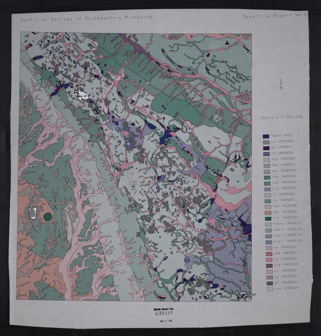
2 MAP AREA ROO< INDEX MAP OF MINNESOTA SHOWIN LOCATION OF MAP AREA 92 Suthwestern Minnesta-Surficial gelgic map 1 Minn. el. Survey Open-File Reprt 94-2
 '0 g 'R N Ice Depsits (In places mdified by later surficial prcesses) I I t [ tl I tl I rn I CORRELATION OF MAP UNITS Stream Depsits I Imdl ts d [ d F*1 d sb sbd yd-c I I S ld l EJ Lake")
3 til c: :T I;; c; 3 3: 5 I;; S ::> n : c 8 0' c 3 '0 "' t-.> 3: ;.? (") ;<. til < -g ::l :!1 0" ;0 (") '0 g 'R N Ice Depsits (In places mdified by later surficial prcesses) I I t [ tl I tl I rn I CORRELATION OF MAP UNITS Stream Depsits I Imdl ts d [ d F*1 d sb sbd yd-c I I S ld l EJ Lake Depsits I I , S- Bedrck,L, } Late Wiscnsinan } Wiscnsinan } Pre Wiscnsinan majr uncnfrmity B } Hlcene Pleistcene Early } Prterzic QUATERNARY PROTEROZIC
; sme were drained artificially.")
4 DESCRIPTION OF MAP UNITS HOLOCENE Organic depsits-includes peat, marshes, and shallw lakes. Typically fund in depressins in hummcky and cllapsed till and alng glacial stream channels. Lake sediment-clay, silt, and sme rganic material. These frmer lakes were cmmnly shallw (less than 10 feet deep); sme were drained artificially. PLEISTOCENE Depsits f the Bemis and Yunger Phases f the Des Mines Lbe (Late Wiscnsinan) Till f the Bemis mraine-till with lenses f srted sediment. Matrix texture is lam t clay '-----==---J lam. Yellw-brwn where xidized, gray where unxidized. Cntains pebbles f carbnate, felsic- and mafic-igneus rcks, shale, chert, and sme lignite. Depsited alng frmer ice frnt. The mraine frms prminent ridge in nrthwest part f map area; it becmes brader and thinner in its suthward extent. Inferred frm limited sampling and extraplatin frm adjining areas in Suth Dakta t cntain supraglacial, prglacial, subglacial, and ice-thrust material. Supraglacial till- Hummcky till with discntinuus lenses f clay, silt, sand, and gravel. Matrix texture is lam t clay lam. Till clr and pebble assemblage similar t that f Bemis mraine (unit tbd), thugh till is generally mre deeply xidized. Till was depsited n wasting ice and was subjected t repeated mass mvement during depsitin. Includes small areas f supraglaciallake and stream sediment. Subglacial till-lw-relief depsits f hmgeneus till. Matrix texture is lam t clay lam. Till clr and pebble assemblage similar t that f Bemis mraine (unit tbd), thugh till is generally nt as deeply xidized. Lcally verlain by thin (apprximately 10 feet thick), discntinuus supraglacial and englacial till and srted sediment that typically frm subparallel ridges transverse t and, less cmmnly, parallel t inferred directin f glacial ice flw. Till with stream-mdified surface-till mdified by flwing water; lcally fluvially erded and streamlined. Matrix texture is lam t clay lam. Pebble assemblage and till clr are the 6 same as that f the Bemis mraine till (unit tbd). Lcally verlain by thin lag f sand and gravel r cvered with silt and clay. Channel scars cmmn. Cllapsed unit (ttd-c) was depsited n ice surface, which was subsequently undermined by subglacial water flw, causing cllapse f thinned ice and its verlying depsit; resulting tpgraphy and stratigraphy are chatic and deranged. Till mdified by slpe prcesses-till alng slpe f Cteau des Prairies (a glacial ersinal scarp). Mdified by slpe wash and mass mvement. Matrix texture, clr, and pebble assemblage similar t Bemis mraine till (map unit tbd). Cllapsed unit (tmd-c) was depsited B n ice surface, which was subsequently undermined by subglacial water flw, causing cllapse f thinned ice and its verlying depsit; resulting tpgraphy and stratigraphy are chatic and deranged. Till verlain by thin lake sediment-lw-relief area f till with discntinuus, silty, clayey cap. Temprarily cvered by ice-impunded lake. Includes lw-relief ice-walled-lake plains. Sme areas f rganic accumulatin are t small t shw at map scale. Till texture, clr, and pebble assemblage similar t Bemis mraine till (unit tbd). Stream sediment beynd Bemis mraine-sand and gravel depsited by meltwater that issued frm ice at the Bemis ice psitin. Texture generally becmes prgressively finer- t sand and silt-further up sectin and farther frm frmer ice frnt. Includes sediment f cntempraneus nnglacial tributaries and yunger, pstglacial streams, especially alng mdem stream curses. Dendritic, integrated netwrk f streams takes advantage f lder glacial and nnglacial stream channels, resulting in stream channels f multiple ages and levels. Suthwestern Minnesta-Surficial gelgic map 3 Minn. el. Survey Open-File Reprt 94-2

5 Stream sediment verlain by till-sand and gravel depsited by subglacial meltwater stream and buried by supraglaciai and englacial till and lake sediment; lcatin inferred frm tpgraphic expressin and subsurface data; interpreted as tunnel-vahey depsits. Stream sediment behind the Bemis mraine-sand, gravel, and silt depsited by meltwater that issued [rm stagnating r retreating ice behind the Bemis mraine. Includes yunger glacial and pstglacial stream sediment and clluvium. Stream netwrk prly integrated wing t B depsitin alng melting ice frnt, ice cllapse, and lw stream gradient. Cllapsed unit (sd-c) was depsited n ice surface, which was subsequently undermined by subglacial water flw, causing the cllapse f the thinned ice and its verlying depsit; the resulting stream netwrk is in places segmented and chatic and has disrdered depsits. Stream sediment buried by lake sediment-similar t stream sediment behind the Bemis mraine (unit sd) but buried by thin clay, silt, fine sand, and rganic depsits. Streams flwing dwn Cteau des Prairies slpe created fans that caused water t pnd alng nrthwest-sutheast-trending drainage at slpe base. Sediment f ice-walled glacial lakes-lake sediment in high tpgraphic psitin. Depsited in pls in stagnant ice; includes sand and gravel alng frmer lake rims and sand, silt, clayrhythmically layered in places-near frmer lake centers. Cmmnly cntains thick, till-like debris-flw depsits. Frms flat-tpped circular uplands within hummcky till terrain. Chains f lakes cmmnly parallel frmer ice-marginal channels. Depsits Assciated with the Verdi Ice Psitin f the Des Mines Lbe (Wiscnsinan) Till f the Verdi psitin-lw-relief area f erded till. Similar t till f Bemis mraine (map 8 unit tbd). Matrix texture is lam t clay lam. Pebble assemblage and clr similar t unit tbd, thugh till is slightly mre xidized and leached; lcally cvered with thin (abut 5 feet thick) windblwn sediment. Ice margin prbably nly a few thusand years lder than that f Bemis phase. Stream sediment f the Verdi psitin-sand and gravel depsited by meltwater that issued frm ice frnt; sediment depsited by waning water flw and wind is cmmnly siltier. Channels lcally reccupied by Bemis-age and yunger streams. Unit includes sediment f nnglacial tributaries and yunger streams. Stream netwrk dendritic and well integrated. Older lacial Depsits (Pre Wiscnsinan) Till-Very dense till. Frms lw-relief, erded till plain that was dissected by yunger glacial streams. Matrix texture is clay lam t silty clay lam. Yellw brwn where xidized, gray where unxidized. Pebbles include carbnate, felsic- and mafic-igneus rcks, and shale. Lcally verlain by windblwn sediment. lacial stream sediment encuntered in scattered brehles. Till with stream-mdified surface-till mdified by flwing water; lcally fluvially erded. Channel scars cmmn. Texture, clr, and pebble assemblage are the same as till f map unit t. Lcally verlain by thin lag f sand and gravel r filled with silt and clay. Till verlain by windblwn sediment-till f map unit t verlain by mre than 5 feet f windblwn silt, fine sand, and clay. Windblwn sediment verlying stream sediment encuntered in scattered brehles. Till verlain by lake sediment-singular shallw depsit f silt, clay, and rganic depsits verlying till similar t map unit t. The basin, near twn f Jasper, is circular depressin reflecting lcal lw in Siux Quartzite surface; it cntains late-glacial and Hlcene lake sediment. Stream sediment-sand and gravel depsited by meltwater that issued frm lder, incmpletely preserved ice psitin(s). Sme stream channels were repeatedly reccupied by Verdi- and Bemis-age and yunger streams. Mapped in all slpe psitins, including the interfluves f yunger streams. Cmmnly capped with lcally thick silty stream and windblw sediment. Suthwestern Minnesta-Surficial gelgic map 4 Minn. e!. Survey Open-File Reprt 94-2

6 I... EARLY PROTEROZOIC Siux Quartzite-Expsures and shallwly buried bedrck f Prterzic Siux Quartzite. Extremely indurated, pink, sandstne-dminated quartz arenite f terrestrial fluvial rigin. Has frmed a tpgraphic high since Prterzic time. Lcally glacially streamljned, striated, and wind plished. DESCRIPTION OF MAP SYMBOLS elgic cntact-established frm aerial phtgraphs, gemrphlgy and examinatin f surficial material. Suthwestern Minnesta-Surficial gelgic map 5 Minn. el. Survey Open-File Reprt 94-2
7
SOIL PROPERTIES STUDY NOTES
 SOIL PROPERTIES STUDY NOTES UNIT I SOIL PROPERTIES Objectives and Values f Getechnical Engineering Physical prperties f sil Phase relatins, Grain size distributin, Atterberg Limits, Sil descriptin and
Unit 5: Surface Processes
 Unit 5: Surface Prcesses What are the prcesses that shape ur Earth? Name: 1 Tpics: Weathering: Physical vs. Chemical Sil Frmatin Agents f Ersin Stream Velcity and Transprted Particle Size Changes caused
UNIT IX: ROCKS NOTES PACKET
 UNIT IX: Rcks Ntes Packet UNIT IX: ROCKS NOTES PACKET Picture: Lwer Falls n the Genesee River in Rchester, NY. Here the variable weathering rates have expsed a number f unique rck layers all f which are
Soil Relative Dating of Moraine and Outwash-terrace Sequences in the Northern Part of the Upper Arkansas Valley, Central Colorado, U.S.A.
 Arctic and Alpine Research, Vl. 3, N.4, 1998, pp. 349-361 Sil Relative Dating f Mraine and Outwash-terrace Sequences in the Nrthern Part f the Upper Arkansas Valley, Central Clrad, U.S.A. Alan R. Nelsn
Lornshill Academy. Geography Department National Revision Physical Environments Rivers
 Lrnshill Academy Gegraphy Department Natinal Revisin Physical Envirnments Rivers Revisin Ntes fr Rivers What yu need t knw: 1. Hw rivers erde, transprt and depsit. 2. The Upper Curse: Frmatin f a V-shaped
GEOL 2920C The Sedimentary Rock Cycle of Mars & Earth Eberswalde fan deposits: deltaic or alluvial? Deltas at Aeolis Dorsa(?
 GEOL 2920C The Sedimentary Rck Cycle f Mars & Earth Week 12 Basin Scale Prcesses n Mars I (April 16, 2018) Discussin Pints, Key Equatins, Key Figures (prepared by Jesse Tarnas) Eberswalde fan depsits:
ATE!lll!^l^,;., G f. ^?!«.LSURv E y
 ATE!lll!^l^,;., G f ^?!«.LSURv E y 3 305100005 339 Digitized by the Internet Archive in 2012 with funding frm University f Illinis Urbana-Champaign http://archive.rg/details/glacialtillsunde69line ENVIRONMENTAL
Basin development and deposition of the Bongaya Formation in the Pitas Area, Northern Sabah.
 Ge. Sc. Malaysia, Bulletin 29, July 1991; pp. 183-193 Basin develpment and depsitin f the Bngaya Frmatin in the Pitas Area, Nrthern Sabah. F. TONGKUL Earth Science Dept., Universiti Kebangsaan Malaysia,
Sediment Basin (SB) Description. Appropriate Uses. Design and Installation
 Description. Appropriate Uses. Design and Installation") Descriptin A sediment basin is a temprary pnd built n a cnstructin site t capture erded r disturbed sil transprted in strm runff prir t discharge frm the site. Sediment basins are designed t capture site
Descriptin A sediment basin is a temprary pnd built n a cnstructin site t capture erded r disturbed sil transprted in strm runff prir t discharge frm the site. Sediment basins are designed t capture site
FIELD TRIP I: DEGLACIATION OF CENTRAL LON(; ISLAND Les Sirkin Earth Science Adelphi University Garden City, NY 11530
 159 FIELD TRIP I: DEGLACIATION OF CENTRAL LON(; ISLAND Les Sirkin Earth Science Adelphi University Garden City, NY 11530 This trip cvers the gelgy f a suth t nrth transect thrugh the sequence flate Wiscnsinan
TRWD Stream Trailer Demonstration Guide
 TRWD Stream Trailer Demnstratin Guide Objectives: The Student Will Observe and interact with an evlving river and wetland. Understand the three cmpnents f a river system Understand the rle ersin plays
A pollen diagram from Norwich Crag at Outney Common, Bungay, Suffolk
 Xew Phytnl. (1988), 110, ()()3 606 A pllen diagram frm Nrwich Crag at Outney Cmmn, Bungay, Sufflk BY R. G. WEST Subdepartment f Quaternary Research, University f Cambridge, Cambridge CB2.3EA, UK (Received
the O.D.M. The property consists of 18 contiguous unpatented mining claims, containing approximately 720 acres. The numbers of the claims are : -
 - P 67 PRPFRTY i^,ril'.,lv-*j: 42A10NW8767 6.857 DUNDNALD 0 10 The prperty cnsists f 18 cntiguus unpatented mining claims, cntaining apprximately 720 acres. The numbers f the claims are : - L. 782-85,
Nye County Groundwater Evaluation Drilling Program. Levi Kryder Nye County NWRPO May 5, 2011
 Nye Cunty Grundwater Evaluatin Drilling Prgram Levi Kryder Nye Cunty NWRPO May 5, 2011 Outline Grundwater Evaluatin prgram Drilling prgram bjectives Brehle lcatins Data cllectin Results by gegraphic lcatin
Sediment and sedimentary rocks Sediment
 Sediment and sedimentary rocks Sediment From sediments to sedimentary rocks (transportation, deposition, preservation and lithification) Types of sedimentary rocks (clastic, chemical and organic) Sedimentary
Landscape. Review Note Cards
 Landscape Review Note Cards Last Ice Age Pleistocene Epoch that occurred about 22,000 Years ago Glacier A large, long lasting mass of ice which forms on land and moves downhill because of gravity. Continental
Geological-Geotechnical Studies for Siting
 EGN 111 R. L. LANGENHEfM, JR. DEPT. GEOL. UNIV. ILLINOIS 234 N.H. B., 1301 W. GREEN ST. URBANA, ILLINOIS 61801 Gelgical-Getechnical Studies fr Siting the Supercnducting Super Cllider in Illinis Preliminary
Principles of Carbonate Reservoirs
 Online In-Service Training and Supprt Prgram Hands-n technical presentatins and exercises, tls, techniques, wrkflws, vide recrdings, and case studies Principles f Carbnate Reservirs Understand the micr
Ch irk Sewage Treatment Works Phase 11
 THE CLWYD-POWYS ARCHAEOLOGICAL TRUST Ch irk Sewage Treatment Wrks Phase 11 ARCHAEOLOGICAL INVESTIGATIONS AT DARLAND WOOD CPAT Reprt N 41 CPAT Reprt N 41 Ch irk Sewage Treatment Wrks Phase 11 ARCHAEOLOGICAL
Prentice Hall EARTH SCIENCE
 Prentice Hall EARTH SCIENCE Tarbuck Lutgens Chapter 7 Glaciers, Desert, and Wind 7.1 Glaciers Types of Glaciers A glacier is a thick ice mass that forms above the snowline over hundreds or thousands of
GEOGRAPHY 3340 EXAM 1 NOTES AND STUDY GUIDE
 GEOGRAPHY 3340 EXAM 1 NOTES AND STUDY GUIDE Sctt Phillips NOTE: This guide is t cver sme f the main tpics we have discussed but des nt cver everything n the exam. T d well, yu need t als read and study
Seismic and borehole analysis of Pantai Kundor, Melaka
 Gel. Sc. MalaYJia, Bulletin 35, July 1994; pp. 61-68 Seismic and brehle analysis f Pantai Kundr, Melaka ABD. RAHM SAMSUDN AND UMAR HAMzAH Jabatan Gelgi Universiti Kebangsaan Malaysia 43600 Bangi, Selangr
The Geology of Sebago Lake State Park
 Maine Geologic Facts and Localities September, 2002 43 55 17.46 N, 70 34 13.07 W Text by Robert Johnston, Department of Agriculture, Conservation & Forestry 1 Map by Robert Johnston Introduction Sebago
Geology and New England Landscapes
 Geology and New England Landscapes Jim Turenne, CPSS USDA-NRCS Warwick, RI. http://nesoil.com Why Geology? Provides the big picture of site conditions. Major part of soil formation (parent material and
Project W.W. Shilts and L.E. Farrell Terrain Sciences Division
 27. SUBBOTTOM PROFLNG OF CANADAN SHELD LAKES - MPLCATONS FOR NTERPRETNG EFFECTS OF ACD RAN Prject 800027 W.W. Shilts and L.E. Farrell Terrain Sciences Divisin Shilts, W. W. and Farrell, L.E., Subbttm prfiling
Stratigraphy of placer gold deposits; over. urden drilling In Chaudiere Valley, Que ec 1
 - 84 - Stratigraphy f placer gld depsits; ver. urden drilling n Chaudiere Valley Que ec 1 Shilts W.W. and Smith S.L. Stratigraphy f placer gld depsits; verburden drilling in Chaudiere Valley Quebec; in
Flood, R.D., Piper, D.J.W., Klaus, A., and Peterson, L.C. (Eds.), 1997 Proceedings of the Ocean Drilling Program, Scientific Results, Vol.
, 1997 Proceedings of the Ocean Drilling Program, Scientific Results, Vol.") Fld, R.D., Piper, D.J.W., Klaus, A., and Petersn, L.C. (Eds.), 1997 Prceedings f the Ocean Drilling Prgram, Scientific Results, Vl. 155 *6. MASS-TRANSPORT DEPOSITS OF THE AMAZON FAN 1 D.J.W. Piper, 2 C.
Fld, R.D., Piper, D.J.W., Klaus, A., and Petersn, L.C. (Eds.), 1997 Prceedings f the Ocean Drilling Prgram, Scientific Results, Vl. 155 *6. MASS-TRANSPORT DEPOSITS OF THE AMAZON FAN 1 D.J.W. Piper, 2 C.
Buchanan Well No. 28 Farrn: Zach Justice. Drillers log (0-4815) Well No.: Gamma Ray log (0-1904) Location: Buchanan County
 Well No.: Gamma Ray log (0-1904) Location: Buchanan County") VDMR Well N. 563 Operatr: United Fuel Gas C. Buchanan Well N. 28 Farrn: Zach Justice Drillers lg (0-4815) Well N.: 8848 Gamma Ray lg (0-1904) Lcatin: Buchanan Cunty Sample lg (2031-3009) 11, 150' S f 37
VDMR Well N. 563 Operatr: United Fuel Gas C. Buchanan Well N. 28 Farrn: Zach Justice Drillers lg (0-4815) Well N.: 8848 Gamma Ray lg (0-1904) Lcatin: Buchanan Cunty Sample lg (2031-3009) 11, 150' S f 37
Infilled Kettle Hole, Easton, Aroostook County, Maine
 Maine Geologic Facts and Localities June, 1997, Maine 46 41 26.40 N, 67 48 35.74 W Text by Tom Weddle, Department of Agriculture, Conservation & Forestry 1 Introduction As the last continental glacier
,Baynes Lake. TO...?&.?...A 2...KO.?'!!&... Sr. *logical Engineer
 > i evernment OF BRITISH COLUMBIA a TO...?&.?...A 2....KO.?'!!&... Sr. *logical Engineer... Grou,,water. Section Hydrology Division Wat.er... In~.~s.tiga.ti.On.s..Branck.... 5 u BJECT...C;.roun.dw.ater...Snve
 UNIT DESCRIPTIONS: Artificial Fill, Undocumented (Afu): Locally derived sandy silt and silty sand, locally with clay and varying amounts of gravel and man-made debris. Abundant concrete rubble, in places
The Palmer Hill Glacial-Marine Delta, Whitefield, Maine
 Maine Geologic Facts and Localities December, 2010, Maine 44 o 10 12.16 N, 69 o 37 18.93 W Text by Woodrow Thompson, Department of Agriculture, Conservation & Forestry 1 Introduction The most recent continental
11/22/2010. Groundwater in Unconsolidated Deposits. Alluvial (fluvial) deposits. - consist of gravel, sand, silt and clay
 deposits. - consist of gravel, sand, silt and clay") Groundwater in Unconsolidated Deposits Alluvial (fluvial) deposits - consist of gravel, sand, silt and clay - laid down by physical processes in rivers and flood plains - major sources for water supplies
Groundwater in Unconsolidated Deposits Alluvial (fluvial) deposits - consist of gravel, sand, silt and clay - laid down by physical processes in rivers and flood plains - major sources for water supplies
Chapter 2. Wearing Down Landforms: Rivers and Ice. Physical Weathering
 Chapter 2 Wearing Down Landforms: Rivers and Ice Physical Weathering Weathering vs. Erosion Weathering is the breakdown of rock and minerals. Erosion is a two fold process that starts with 1) breakdown
Arizona Geological Society
 Arina Gelgical Sciety Field Trip t Clssal Cave and the Surrunding Area, Pima Cunty, Arina Leader: William Peachey, Spelelgist Clssal Cave Muntain Park February 19, 2000 Clssal Cave Muntain Park Clssal
SD-100 SD-200 SITE AND EXPLORATION PLAN SODO SEGMENT. FIG. 3 Sheet 4 of 9. Seattle Monorail Project Seattle, Washington Scale in Feet
 Central Parking Lot potential downhole arrary location (site visit //) PREFERRED New Parking Area File: I: \Drafting \\- \plans \-- Plans.dwg Date: -- Author: LR Current downhole array location LEGEND
Reconstruction of topography and related depositional systems during active thrusting
 JOURNAL OF GEOPHYSICAL RESEARCH, VOL. 99, NO. B10, PAGES 20,281-20,297, OCTOBER 10, 1994 Recnstructin f tpgraphy and related depsitinal systems during active thrusting Duglas W. Burbank Department f Gelgical
A Seismic Refraction Survey
 488 S 14.GS: CIR488 ILLINOIS GEOLOGICAL SURVEY LIBRARY z I J c. 1 STATE OF ILLINOIS DEPARTMENT OF REGISTRATION AND EDUCATION A Seismic Refractin Survey f the Meredsia Channel Area f Nrthwestern Illinis
MEMORANDUM. wa.tsr..-z.n~.e.s-t.i~at.i.o.ns... Branch... Mr. Webster contends that prior to excavation of the gravel
 TO... J. C. Foweraker 2... Head Gr o w a t er S e c t i on... Hyar....og~~~.~.~vis.ion... wa.tsr..-z.n~.e.s-t.i~at.i.o.ns... Branch... eernment OF BRITISH COLUMBIA MEMORANDUM II 0 PROM A. P. Kohut, Geological
Lecture Outline Wednesday - Friday February 14-16, 2018
 Lecture Outline Wednesday - Friday February 14-16, 2018 Quiz 2 scheduled for Friday Feb 23 (Interlude B, Chapters 6,7) Questions? Chapter 6 Pages of the Past: Sedimentary Rocks Key Points for today Be
o Land and water both are heated by solar radiation, but land
 Benchmark: SC.D.l.4.1 The student knws hw climatic patterns n Earth result frm an interplay f many factrs (Earth's tpgraphy, its rtatin'tn its axis, slar radiatin, the transfer f heat energy where the
Evidence for Permafrost on Long Island
 Evidence for Permafrost on Long Island By Vesna Kundic and Gilbert N. Hanson Department of Geosciences Stony Brook University Permafrost or permanently frozen ground is soil or rock that remains below
Postglacial environments in relation to landscape and soils on the Cary drift, Iowa
 Vlume 35 Number 549 Pstglacial envirnments in relatin t landscape and sils n the Cary drift, wa Article 1 Nvember 1966 Pstglacial envirnments in relatin t landscape and sils n the Cary drift, wa Patrick
KATY, TX ROGER SIGLER TREE TOAD DRIVE VAN WINGERDEN P.O. BOX 902 LAKE ISABELLA, CA 93240
 SUBMARINE FLOW AND SLIDE DEPOSITS IN THE KINGSTON PEAK FORMATION, KINGSTON RANGE, MOJAVE DESERT, CALIFORNIA: EVIDENCE FOR CATASTROPHIC INITIATION OF NOAH'S FLOOD ROGER SIGLER 19114 TREE TOAD DRIVE VAN
NDWRCDP Disclaimer This work was supported by the National Decentralized Water Resources Capacity Development Project (NDWRCDP) with funding provided
 with funding provided") Glacial Landforms NDWRCDP Disclaimer This work was supported by the National Decentralized Water Resources Capacity Development Project (NDWRCDP) with funding provided by the U.S. Environmental Protection
Glacial Landforms NDWRCDP Disclaimer This work was supported by the National Decentralized Water Resources Capacity Development Project (NDWRCDP) with funding provided by the U.S. Environmental Protection
A sedimentary sequence in the Glacial Lake Proven basin: the Rolling River section, Riding Mountain, Manitoba
 Prairie Perspectives 111 A sedimentary sequence in the Glacial Lake Proven basin: the Rolling River section, Riding Mountain, Manitoba Roderick A. McGinn, Brandon University Abstract: The Glacial Lake
A new depositional model for the classical turbidite locality at San Clemente State Beach, California
 A new depsitinal mdel fr the classical turbidite lcality at San Clemente State Beach, Califrnia Hilari Camach, Cathy J. Busby, and Ben Kneller ABSTRACT The Micene turbidite system expsed in the beach cliffs
Appendix F4.11 Geologic Unit Summaries, Hazard Areas, and Boring Locations
 Appendix F4.11 Geologic Unit Summaries, Hazard Areas, and Boring Locations Appendix F4.11 Geologic Unit Summaries and Hazard Areas TABLE F4.11-1 Summary of Geologic Units and their Engineering Properties
Guide to Using the Rubric to Score the Klf4 PREBUILD Model for Science Olympiad National Competitions
 Guide t Using the Rubric t Scre the Klf4 PREBUILD Mdel fr Science Olympiad 2010-2011 Natinal Cmpetitins These instructins are t help the event supervisr and scring judges use the rubric develped by the
GEOLOGICAL SURVEY OF CANADA PAPER REPORT OF ACTIVITIES, Part A: April to October, 1968 DEPARTMENT OF ENERGY, MINES AND RESOURCES.
 GEOLOGICAL SURVEY OF CANADA PAPER 69-1 Part A REPORT OF ACTIVITIES, Part A: April to October, 1968 DEPARTMENT OF ENERGY, MINES AND RESOURCES @ Crown Copyrights reserved Availahlc by rn:~il from thc Quecn's
DEFENSE OCCUPATIONAL AND ENVIRONMENTAL HEALTH READINESS SYSTEM (DOEHRS) ENVIRONMENTAL HEALTH SAMPLING ELECTRONIC DATA DELIVERABLE (EDD) GUIDE
 ENVIRONMENTAL HEALTH SAMPLING ELECTRONIC DATA DELIVERABLE (EDD) GUIDE") DEFENSE OCCUPATIOL AND ENVIRONMENTAL HEALTH READINESS SYSTEM (DOEHRS) ENVIRONMENTAL HEALTH SAMPLING ELECTRONIC DATA DELIVERABLE (EDD) GUIDE 20 JUNE 2017 V1.0 i TABLE OF CONTENTS 1 INTRODUCTION... 1 2 CONCEPT
DEFENSE OCCUPATIOL AND ENVIRONMENTAL HEALTH READINESS SYSTEM (DOEHRS) ENVIRONMENTAL HEALTH SAMPLING ELECTRONIC DATA DELIVERABLE (EDD) GUIDE 20 JUNE 2017 V1.0 i TABLE OF CONTENTS 1 INTRODUCTION... 1 2 CONCEPT
IOWA GEOLOGICAL SURVEY IOWA CITY, IOWA. SAMUEL J. TUTHILL, Director and State Geologist REPORT OF INVESTIGATIONS 10
 IOWA GEOLOGICAL SURVEY IOWA CITY, IOWA SAMUEL J. TUTHILL, Directr and State Gelgist REPORT OF INVESTIGATIONS 10 STRATIGRAPHY OF THE UPPER DEVONIAN SHELL ROCK FORMATION OF NORTOCENTRAL IOWA by DONALD L.
Science EOG Review: Landforms
 Mathematician Science EOG Review: Landforms Vocabulary Definition Term canyon deep, large, V- shaped valley formed by a river over millions of years of erosion; sometimes called gorges (example: Linville
MAJOR 40,000m GOLD EXPLORATION DRILLING PROGRAM COMMENCES
 2 Nvember 2016 MAJOR 40,000m GOLD EXPLORATION DRILLING PROGRAM COMMENCES Highlights A majr explratin drilling prgram has cmmenced n the Tampia Gld Prject t scpe the extent f the knwn gld resurce thrugh
Edexcel GCSE Physics
 Edexcel GCSE Physics Tpic 10: Electricity and circuits Ntes (Cntent in bld is fr Higher Tier nly) www.pmt.educatin The Structure f the Atm Psitively charged nucleus surrunded by negatively charged electrns
UC A-G Earth Science. Gorman Learning Center (052344) Basic Course Information
 Basic Course Information") UC A-G Earth Science Grman Learning Center (052344) Basic Curse Infrmatin Title: UC A-G Earth Science Transcript abbreviatins: A-G Earth Sci / A-G Earth Sci Length f curse: Full Year Subject area: Labratry
UC A-G Earth Science Grman Learning Center (052344) Basic Curse Infrmatin Title: UC A-G Earth Science Transcript abbreviatins: A-G Earth Sci / A-G Earth Sci Length f curse: Full Year Subject area: Labratry
Surficial Geology of Antioch Quadrangle
 Illinois Preliminary Geologic Map IPGM Antioch-SG Surficial Geology of Antioch Quadrangle Lake County, Illinois and Kenosha County, Wisconsin Andrew J. Stumpf and Michael L. Barnhardt 2005 Department of
Soil Formation. Lesson Plan: NRES B2-4
 Soil Formation Lesson Plan: NRES B2-4 1 Anticipated Problems 1. What are five different factors that affect soil formation? 2. What are some different types of parent material that affect soils? 3. What
LESSON 09: EARTH S STRUCTURE
 G E O S C I E N C E : E A R T H A N D F I R E G E O S C I E N C E S : E A R T H A N D F I R E LESSON 09: EARTH S STRUCTURE READING & RESEARCH Read KSE Earth s Structure, pp. 8-9. Read DSE Structure f the
Dual-Pol Refresher and Previous Research Christina Crowe Journeyman Forecaster WFO Huntsville, AL
 Uses f Dual-Pl Radar fr Trnades: Mre Than Just Debris Dual-Pl Refresher and Previus Research Christina Crwe Jurneyman Frecaster WFO Huntsville, AL Dual-Pl Variable Refresher: What d they mean? Hrizntal
Subsurface Geology of the Kennebec River
 Maine Geologic Facts and Localities July, 1998 Subsurface Geology of the Kennebec River 43 54 40.75 N, 69 48 29.01 W Text by Daniel B. Locke, Department of Agriculture, Conservation & Forestry 1 Map by
What are the different ways rocks can be weathered?
 Romano - 223 What are the different ways rocks can be weathered? Weathering - the breakdown of rocks and minerals at the Earth s surface 1. 2. PHYSICAL WEATHERING Rock is broken into smaller pieces with
Bell Ringer. Are soil and dirt the same material? In your explanation be sure to talk about plants.
 Bell Ringer Are soil and dirt the same material? In your explanation be sure to talk about plants. 5.3 Mass Movements Triggers of Mass Movements The transfer of rock and soil downslope due to gravity is
GEOLOGIC LOG " coarse- to very coarse-grained, fairly wellsorted, subangular to rounded.
 OWNER: Sydnr Hydrdynamics, Inc. DRILLER: Sydnr Hydrdynamics, Inc. COUNTY: Hanver (Atlee) GEOLOGIC LOG VDMR - 1770 WWCR - 98 TOTAL DEPTH - 370' Depth in Feet COLUMBIA GROUP (0-50) - 10 10-20 20-30 Sand
Soils in Minnesota Calcareous Fens
 Soils in Minnesota Calcareous Fens MGWA TECHNICAL WORKSHOP June 18, 2004 George Poch 6/23/2004 1 Introduction Our presentation today is to show What soils are in the Fen areas How they have been mapped
Erosion and sediment transport measurement
 49 Ersin and sediment transprt measurement (Prceedings f the Flrence Sympsium, June 1981) Sme bservatins n the mvement f cbbles n a streambed LUNA B. LEOPOLD Department f Gelgy and Gephysics University
GL3521 Notes. Lecture 1 (19/1/17) Sedimentary Environments (Carbonates):
 Sedimentary Environments (Carbonates):") GL3521 Ntes Lecture 1 (19/1/17) Sedimentary Envirnments (Carbnates): Clastics (r siliciclastics) are frmed thrugh ersin and transprtatin Autchthnus: generated in situ Carbnates tend t reflect the envirnment
GL3521 Ntes Lecture 1 (19/1/17) Sedimentary Envirnments (Carbnates): Clastics (r siliciclastics) are frmed thrugh ersin and transprtatin Autchthnus: generated in situ Carbnates tend t reflect the envirnment
BLAKENEY ESKER AND HOW IT FORMED. The Blakeney Esker is a ridge, around 3.5 km in length, which runs southeastwards
 BLAKENEY ESKER AND HOW IT FORMED Introduction The Blakeney Esker is a ridge, around 3.5 km in length, which runs southeastwards from west of Blakeney, to Wiveton Downs, north-west of Glandford, in north
Unit E: Basic Principles of Soil Science. Lesson 2: Understanding Soil Formation
 Unit E: Basic Principles of Soil Science Lesson 2: Understanding Soil Formation Important Terms Alluvium Bedrock Chemical weathering Climate Glacial till Loess Native vegetation Organic matter Outwash
FROM BEDROCK MONITORING
 HYDROGEOLOGIC OBSERVATIONS FROM BEDROCK MONITORING WELL NESTS in the BIG SPRING BASIN Open-File Reprt 90-1 Pslviihe Luana aa Iwa Department f Natural Resurces Larry J. Wilsn, Directr December 1990 HYDROGEOLOGIC
QUATERNARY AND GLACIAL GEOLOGY
 QUATERNARY AND GLACIAL GEOLOGY JURGEN EHLERS Geologisches Landesamt, Germany Translated from Allgemeine und historische Quartdrgeologie English version by Philip L. Gibbard JOHN WILEY & SONS Chichester
Date. Note. Diamond Drilling. Township of BARTLETT Report NQ 14. Claim N9. Hole NO. Footage. Notes: Feb/59. Mar/59. Mar/ ' 415,0' 463.
 Diamnd Drilling 42A*3NE*l*a M BARTLETT II 010 Twnship f BARTLETT Reprt NQ 14 Wrk perfrmed by: Queenstn Gld Mines Limited Claim N9 P 42742 Hle NO i 2 Ftage 489.0' 415,0' Date Feb/59 Mar/59 Nte 4 463.0'
The Montauk Peninsula: Data and Preliminary Interpretations of the Ditch Plains Area Introduction
 The Montauk Peninsula: Data and Preliminary Interpretations of the Ditch Plains Area John A. Black GSI Patchogue, New York R.S. Welch Suffolk Community College Selden, New York Introduction Sirkin, (1982)
Cattaraugus Creek: A Story of Flowing Water and the Geology of the Channel It Flows Through Presentation to West Valley Citizen Task Force 4/27/16
 Cattaraugus Creek: A Story of Flowing Water and the Geology of the Channel It Flows Through Presentation to West Valley Citizen Task Force 4/27/16 Raymond C. Vaughan, Ph.D. What happens if you drop a
Geology of the Black River and Paw Paw River Watersheds. Dr. Tara Kneeshaw Grand Valley State University Department of Geology
 Geology of the Black River and Paw Paw River Watersheds Dr. Tara Kneeshaw Grand Valley State University Department of Geology Two Rivers Coalition September 11, 2013 There s nothing boring about Michigan
CARD #1 The Shape of the Land: Effects of Crustal Tilting
 CARD #1 The Shape of the Land: Effects of Crustal Tilting When we look at a birds-eye view of the Great Lakes, it is easy to assume the lakes are all at a similar elevation, but viewed in this way, we
Topic 6: Weathering, Erosion and Erosional-Deposition Systems (workbook p ) Workbook Chapter 4, 5 WEATHERING
 Workbook Chapter 4, 5 WEATHERING") Topic 6: Weathering, Erosion and Erosional-Deposition Systems (workbook p. 95-125) Workbook Chapter 4, 5 THE BIG PICTURE: Weathering, erosion and deposition are processes that cause changes to rock material
Topic 6: Weathering, Erosion and Erosional-Deposition Systems (workbook p. 95-125) Workbook Chapter 4, 5 THE BIG PICTURE: Weathering, erosion and deposition are processes that cause changes to rock material
Lab 7: Sedimentary Structures
 Name: Lab 7: Sedimentary Structures Sedimentary rocks account for a negligibly small fraction of Earth s mass, yet they are commonly encountered because the processes that form them are ubiquitous in the
The future of the Lowland Belizean Savannas?.
 The future of the Lowland Belizean Savannas?. Using cluster analysis to explore multivariate spatial patterns in savanna soils PETER FURLEY & SARAH BEADLE UK Belize association 15 th November 2014 Outline
Watural History Museum Of los Angeles County
 ixjul re^ m i L. I V U EOCENE LLAJAS FORMATION, SIMI VALLEY, SOUTHERN CALIFORNIA Watural Histry Museum Of ls Angeles Cunty Palentlgy Richard L. Squires Department f Gelgical Sciences Califrnia State Dniversity
Subject description processes
 Subject representatin 6.1.2. Subject descriptin prcesses Overview Fur majr prcesses r areas f practice fr representing subjects are classificatin, subject catalging, indexing, and abstracting. The prcesses
Paleo Lab #4 - Sedimentary Environments
 Paleo Lab #4 - Sedimentary Environments page - 1. CHARACTERISTICS OF SEDIMENT Grain size and grain shape: The sizes and shapes of sedimentary particles (grains) are modified considerably during their transportation
Plate Tectonics and the Fossil Record
 Plate Tectnics and the Fssil Recrd Accrding t the thery f plate tectnics, the earth's surface is dynamic. The current cnfiguratin f its land and cean masses is the result f mtins that have ccurred ver
Permafrost-influenced Geomorphic Processes
 Section 4 Permafrost-influenced Geomorphic Processes Geomorphic processes vary greatly among ecoregions in northern Alaska, extending from the Beaufort Sea coast to the Brooks Range (Figure 4.1). Regional
4. What type of glacier forms in a sloping valley between rock walls? a. firn glacier b. ice sheet c. cirque d. alpine glacier
 Multiple Choice Questions 1. The term means the loss of snow and ice by evaporation and melting. a. sublimation b. ablation c. erosion d. abrasion 2. What condition must be met for a glacier to begin flowing
The Building of the NYC Region
 The Building of the NYC Region Definitions Fall Line marks the area where an upland region (continental bedrock) and a coastal plain meet Piedmont the plateau region of the eastern United States which
AN SEM STUDY OF PHYLLOSILICATE DIAGENESIS IN SANDSTONES AND MUDSTONES IN THE WESTPHALIAN COAL MEASURES USING BACK-SCATTERED ELECTRON MICROSCOPY
 Clay Minerals (1986) 21,63-616 AN SEM STUDY OF PHYLLOSILICATE DIAGENESIS IN SANDSTONES AND MUDSTONES IN THE WESTPHALIAN COAL MEASURES USING BACK-SCATTERED ELECTRON MICROSCOPY J. M. HUGGETT BP Petrleum
Greenbush Landslide: June 30 - July 2, 2006
 Maine Geologic Facts and Localities December, 2006 45 o 4 59.76 N, 68 o 38 56.08 W Text by Michael E. Foley, Department of Agriculture, Conservation & Forestry 1 Map by USGS Aerial photo from Introduction
Lower Mainland Surficial Geology From Wisconsin Ice Age to Protocol 21
 Lower Mainland Surficial Geology From Wisconsin Ice Age to Protocol 21 BCEIA BEST Conference 2018 Whistler, BC Kalina Malowany and Virginie Brunetaud Presentation Outline 1. Surficial Geology it s more
GEL 109 Midterm W01, Page points total (1 point per minute is a good pace, but it is good to have time to recheck your answers!
 GEL 109 Midterm W01, Page 1 50 points total (1 point per minute is a good pace, but it is good to have time to recheck your answers!) 1. Where in a water flow is there usually a zone of laminar flow even
README: LIQUEFACTION SUSCEPTIBILITY MAP OF TETON COUNTY, IDAHO. William M. Phillips Digital Database 6
 WHAT IS LIQUEFACTION? README: LIQUEFACTION SUSCEPTIBILITY MAP OF TETON COUNTY, IDAHO William M. Phillips Digital Database 6 Idaho Geological Survey PO Box 443014 University of Idaho Moscow, ID 83844 3014
I. Uniformitarianism- James Hutton s 2-part theory states: A. The geologic processes now at work were also active in the past B. The present physical
 How Earth s Rocks Were Formed I. Uniformitarianism- James Hutton s 2-part theory states: A. The geologic processes now at work were also active in the past B. The present physical features of Earth were
The Hydrologic Cycle
 CONTINENTAL DEPOSITIONAL ENVIRONMENTS fluvial desert lacustrine (lake) Glacial KEY PARAMETERS (VARIABLES) 1. Climate (Hydrologic Cycle) Annual Precip vs. Seasonality 2. Tectonics (Mountains) The Hydrologic
How do glaciers form?
 Glaciers What is a Glacier? A large mass of moving ice that exists year round is called a glacier. Glaciers are formed when snowfall exceeds snow melt year after year Snow and ice remain on the ground
The hydraulic geometry of ephemeral channels in a tectonically active landscape : north flank of the San Bernardino Mountains, California
 Lehigh University Lehigh Preserve Theses and Dissertatins 21 The hydraulic gemetry f ephemeral channels in a tectnically active landscape : nrth flank f the San Bernardin Muntains, Califrnia Sarah A. (Amie)
Depositional Environment
 Depositional Environment Sedimentary depositional environment describes the combination of physical, chemical and biological processes associated with the deposition of a particular type of sediment. Types
Chapter 3 Erosion and Deposition. The Big Question:
 Chapter 3 Erosion and Deposition The Big Question: 1 Design a way to represent and describe the 4 types of mass movement. You may use pictures, diagrams, list, web, chart, etc 2 Chapter 3: Erosion and
s* - *uoeurv E l V E D O
 A mm tt****. - s* - *ueurv E l V E D 4 000 D1SE014.0609 STUGHTN 010 REPRT N THE 1999 EXPLRATIN PRGRAM N THE S A S PRPERTY F P. ADMATTIS A R. GRENIER STUGHTN TWNSHIP, NTS D/1 LARDER LAKE MINING DIVISIN,
SURFICIAL GEOLOGY AND PERFORMANCE ASSESSMENT FOR A RADIOACTIVE WASTE MANAGEMENT FACILITY AT THE NEVADA TEST SITE
 DOE/NV/ 10833-25 UC72 1 SURFICIAL GEOLOGY AND PERFORMANCE ASSESSMENT FOR A RADIOACTIVE WASTE MANAGEMENT FACILITY AT THE NEVADA TEST SITE K. E. Snyder Lockheed Environmental Systems and Technologies Co.
As compaction and cementation of these sediments eventually occur, which area will become siltstone? A) A B) B C) C D) D
 A B) B C) C D) D") 1. A student obtains a cup of quartz sand from a beach. A saltwater solution is poured into the sand and allowed to evaporate. The mineral residue from the saltwater solution cements the sand grains together,
1. A student obtains a cup of quartz sand from a beach. A saltwater solution is poured into the sand and allowed to evaporate. The mineral residue from the saltwater solution cements the sand grains together,