Evaluating Minerals of Environmental Concern Using Spectroscopy
|
|
|
- Janice Richards
- 5 years ago
- Views:
Transcription

1 Evaluating Minerals of Environmental Concern Using Spectroscopy G.A. Swayze, R.N. Clark, C.T. Higgins, R.F. Kokaly, K.E. Livo, T.M. Hoefen, C. Ong, and F.A. Kruse *Presented at the IGARSS 2006 Conference, Denver, Colorado
 Alex, thanks for your guidance! Effects of spectrometer band pass, sampling, and signal-to-noise ratio on spectral identification using the Tetracorder algorithm.")
2 The hydrothermal and structural history of the Cuprite Mining District, southwestern Nevada (CU-Dissertation: Alex advisor) Geology and genesis of advance argillic alteration at Cuprite, Nevada (Econ. Geol., in review) Alex, thanks for your guidance! Effects of spectrometer band pass, sampling, and signal-to-noise ratio on spectral identification using the Tetracorder algorithm. (JGR, 2003).

 spectrometer out to")


3 13-hours/ spectrum 6-seconds/ spectrum USGS Beckman Spectrometer Try hauling a 300 lbs (136 kg) spectrometer out to the field for ground calibration! Alex has simplified work for countless remote-sensing scientists with the ASD spectrometer! ASD Spectrometer
4 Using Imaging Spectroscopy to Map Acidic Mine Waste Swayze, Smith, Clark, Sutley, Pearson, Vance, Hageman, Briggs, Meier, Singleton, and Roth, 2000, Envir. Sci. and Tech.
5 Leadville is located in central Colorado about 130km SW of Denver. The mining district covers a 30 sq. km area above 3000 m. Parts of the district were declared the California Gulch Superfund site by the U.S. EPA because of AMD.
6 Efflorescent salts are an easily dissolved source of heavy metals (e.g., Cu, Pb, As, Zn) that get into surface Metal-rich runoff, which efflorescent salts eventually finds its way into urban and agricultural water supplies. Oxidized pyrite-bearing tailings

7 Secondary minerals that form from oxidation of sulfides in waste rock have diagnostic spectral features in the 1.0-micron region. Each of these minerals is a sensitive indicator of surface ph and their distribution can be used to map the extent of AMDgenerating mine waste.


8 These secondary minerals are deposited in roughly concentric zones emanating from the mine-waste piles. Leach tests indicate that areas with jarosite at the surface produce the lowest ph (~2.5) values.
9 AMD-Comments Spectral mineral maps accelerated remediation efforts by 2 years saving over $2 million in investigation costs at Leadville. Imaging spectroscopy can be used to rapidly screen entire mining districts for potential sources of surface acid drainage. Other AMD Studies: Ong et al., 2003, Proceedings of the 3rd EARSel Workshop on Imaging Spectroscopy; Montero et al., 2005, Chemical Geology; Riaza et al., 2005, International Archieves of the Photogrammetry, Remote Sensing and Spatial Information Sciences, v.34, Part XXX; Dalton et al., 2004, Scientific Investigations Report ; Rockwell et al., 2004, Scientific Investigations Report
10 Deriving quantitative dust measurements related to iron ore handling from airborne hyperspectral data Ong, Cudahy, Caccetta, and Piggott, 2003, Mining Technology, v Environmental Problem: dust deposited by ore handling operations at Port Hedland, Australia have the potential to impact surrounding ecologically sensitive mangroves.


11 Relationship between physicochemical/biophysical properties and spectral data Independent Measurements of Enviromental parameter Dust loads Spectral measurements clean dusted 50 relfectance Ore dusted mangrove leaves can be spectrally distinguished from clean leaves in field measurement. statistical analysis wavelength Pre-processing The same spectral differentiation can be done with HyMap data collected over the affected areas.


12 Multi-temporal temporal map of iron oxide dust on mangroves 1998 Pre-wet Blue: less dust Red: more dust 1999 After cyclone 2002 Pre-wet

13 Impacts of natural environmental phenomenon Magenta = less dust Green = no net change This is a difference image between the dry season (Nov. 1998) and the start of the wet season (April 1999) right after Cyclone Gwenda (category 2) washed the dust off the mangroves.
 as measured form by difference map.")
14 Impacts of dust management Dust management decreased the amount of dust on the mangroves as measured between Nov and Nov (during similar meteorological conditions for both years) as measured form by difference map. This work was awarded the Golden Gecko Award for developing a non-invasive monitoring technique.


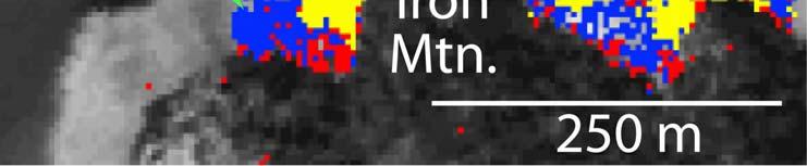
15 Mapping Naturally Occurring Asbestos with Imaging Spectroscopy 50μm Swayze, Kokaly, Higgins, Clinkenbeard, Clark, Lowers, and Sutley, in prep., Geology


16 California NOA Ultramafic rocks contain most of the naturally occurring asbestos Three main belts of ultramafic rocks 43 of 55 counties in California have NOA


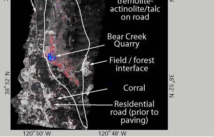
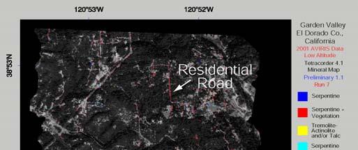
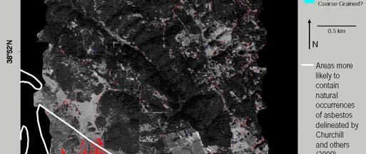
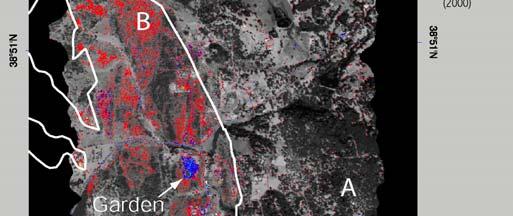
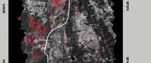
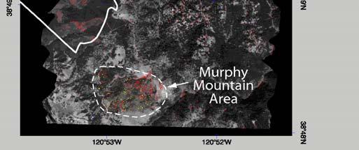
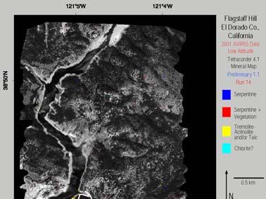
17 Flagstaff Hill Garden Valley Little Bald Mtn Red Hill Mineral Maps from AVIRIS


18 Flagstaff Hill N A 0.5 km White lines from a previous study enclose areas with a higher potential to contain asbestos. They stop at the high water mark but the asbestos-bearing bearing units continue under the water.

19 Fabric barrier Serpentinite outcrop New homes being constructed on the side of a hill cut into serpentine-bearing rock.


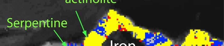
20 Spectrally differentiating between serpentine and talc/tremolite-actinolite is straight forward. Differentiating between talc and tremolite-actinolite is considerably more challenging because of their spectral similarity.


21 Grass+serpentine spectral signatures can be used to map serpentine ne in areas with up to 80% grass cover. Chaparral can also be used to locate e serpentine.
22 NOA-Comments AVIRIS maps agree well with previous California Geological Survey mapping. The method mapped potentially asbestosbearing rocks in areas with up to 80% dry grass cover and is independent of rock type. Other serpentine-based features recognized (roads, quarries, fill areas, etc.). Spectral maps are an important step in the development of tools for mapping NOA in many of the other 42 counties.

23 Environmental Studies of the World Trade Center Dust Swayze, Clark, Sutley, Hoefen, Plumlee, Meeker, Brownfield, Livo, and Morath, 2006, ACS Symposium 919


24 Working Nights at WTC 33 bulk dust samples were collected within a 1 km radius of ground zero Sept th. No dust samples contained greater than 1 wt% chrysotile based on spectroscopic and XRD analysis.


25

26 Chrysotile content in the WTC surface samples This map is based on both spectroscopic and X-ray diffraction analysis of the bulk samples. Two-thirds of the dust contain asbestos but at concentrations below the AVIRIS detection threshold which is about ~ 5 wt%.
27 WTC-Comments Spectra of dust samples indicates that chrysotile asbestos was not distributed uniformly during collapse of the WTC towers being lower to the south perhaps due to this area s proximity to Tower 2, which did not have chrystotile-bearing fireproof insulation. Spectra with a SNR=1:28,000 were needed to detect chyrsotile at levels below 1wt% in the WTC dust. The need for detecting concentrations of hazardous materials at this level and, perhaps, at even lower levels presents an extraordinary challenge for imaging spectrometers designed for emergency response.
by K. Eric Livo1 and Roger N. Clark1 Open-File report (paper edition) U.S. DEPARTMENT OF THE INTERIOR U.S.
 U.S. DEPARTMENT OF THE INTERIOR U.S.") Mapped Minerals at Questa, New Mexico, using Airborne Visible- Infrared Imaging Spectrometer (AVIRIS) Data - Preliminary Report for: First Quarterly Report of the U.S. Geological Survey Investigation of
Mapped Minerals at Questa, New Mexico, using Airborne Visible- Infrared Imaging Spectrometer (AVIRIS) Data - Preliminary Report for: First Quarterly Report of the U.S. Geological Survey Investigation of
Mineral index maps of the southern Namibia using HyMap and ASTER data
 WE4.T06: Geology and Solid Earth V, Wednesday, July 27, 16:00-16:20, #1725 Mineral index maps of the southern Namibia using HyMap and ASTER data Shoko Oshigami 1*, Tatsumi Uezato 1, Yasushi Yamaguchi 1,
Date of Report: EPA agreement number: Center Name and Institution of Ctr. Director: Identifier used by Center for Project: Title of Project:
 Date of Report: March 31, 2003 EPA agreement number: R829515C003 Center Name and Institution of Ctr. Director: Rocky Mountain Regional Hazardous Substance Research Center, Colorado State University, Fort
Applicability of Near-Infrared (NIR) spectroscopy for sensor based sorting of a porphyry copper ore.
 spectroscopy for sensor based sorting of a porphyry copper ore.") Applicability of Near-Infrared (NIR) spectroscopy for sensor based sorting of a porphyry copper ore. OCM conference presentation 07-03-2013 TU Delft, Resource Engineering section M.Dalm MSc. 1 Table of
Applicability of Near-Infrared (NIR) spectroscopy for sensor based sorting of a porphyry copper ore. OCM conference presentation 07-03-2013 TU Delft, Resource Engineering section M.Dalm MSc. 1 Table of
LESSONS LEARNED FROM MINING-INFLUENCED WATERS STUDIES AT THE NEW MEXICO BUREAU OF GEOLOGY AND MINERAL RESOURCES
 LESSONS LEARNED FROM MINING-INFLUENCED WATERS STUDIES AT THE NEW MEXICO BUREAU OF GEOLOGY AND MINERAL RESOURCES Virginia T. McLemore New Mexico Bureau of Geology and Mineral Resources New Mexico Institute
NASA s Airborne Visible/Infrared Imaging Spectrometer (AVIRIS) AVIRIS: PEARL HARBOR, HAWAII
 AVIRIS: PEARL HARBOR, HAWAII") AVIRIS: PEARL HARBOR, HAWAII 000412 NASA s Airborne Visible/Infrared Imaging Spectrometer (AVIRIS) LCLUC Update Robert O. Green (Tom Chrien, presenting) Jet Propulsion Laboratory Overview Objective & Approach
AVIRIS: PEARL HARBOR, HAWAII 000412 NASA s Airborne Visible/Infrared Imaging Spectrometer (AVIRIS) LCLUC Update Robert O. Green (Tom Chrien, presenting) Jet Propulsion Laboratory Overview Objective & Approach
Spectral Variations in Rocks and Soils Containing Ferric Iron Hydroxide and(or) Sulfate Minerals as seen by AVIRIS and Laboratory Spectroscopy
 Sulfate Minerals as seen by AVIRIS and Laboratory Spectroscopy") Spectral Variations in Rocks and Soils Containing Ferric Iron Hydroxide and(or) Sulfate Minerals as seen by AVIRIS and Laboratory Spectroscopy Barnaby W. Rockwell 1 Open-File Report 2004-1431 Version 1.2
Spectral Variations in Rocks and Soils Containing Ferric Iron Hydroxide and(or) Sulfate Minerals as seen by AVIRIS and Laboratory Spectroscopy Barnaby W. Rockwell 1 Open-File Report 2004-1431 Version 1.2
IDENTIFICATION OF TARGETS FOR COPPER MINERALIZATION USING MULTI-SPECTRAL ANALYSIS OF ASTER SATELLITE IMAGES IN HASHTIJAN 1: SHEET, NW IRAN
 IDENTIFICATION OF TARGETS FOR COPPER MINERALIZATION USING MULTI-SPECTRAL ANALYSIS OF ASTER SATELLITE IMAGES IN HASHTIJAN 1:100000 SHEET, NW IRAN Ramin ArameshAsl 1, Peyman Afzal 1,2, Ahmad Adib 1, Naji
MINERALOGY AND CHEMISTRY OF MINE WASTE ROCK PILES IN MINING DISTRICTS IN SOUTHERN COLORADO AND NEW MEXICO
 MINERALOGY AND CHEMISTRY OF MINE WASTE ROCK PILES IN MINING DISTRICTS IN SOUTHERN COLORADO AND NEW MEXICO Virginia T. McLemore and Marcus Silva New Mexico Bureau of Geology and Mineral Resources, New Mexico
Hyperspectral Data as a Tool for Mineral Exploration
 1 Hyperspectral Data as a Tool for Mineral Exploration Nahid Kavoosi, PhD candidate of remote sensing kavoosyn@yahoo.com Nahid Kavoosi Abstract In Geology a lot of minerals and rocks have characteristic
Characterization and comparison of mine wastes from legacy mines in NM
 Characterization and comparison of mine wastes from legacy mines in NM Presentation by: John Asafo-Akowuah May 9, 2017 Overview Purpose Study Area Methodology Results Conclusions Recommendations Purpose
A prospective and retrospective spatial sampling scheme to characterize geochemicals in a mine tailings area
 A prospective and retrospective spatial sampling scheme to characterize geochemicals in a mine tailings area Pravesh Debba CSIR Built Environment Logistics and Quantitative Methods (LQM) South Africa Presented
Application of near-infrared (NIR) spectroscopy to sensor based sorting of an epithermal Au-Ag ore
 spectroscopy to sensor based sorting of an epithermal Au-Ag ore") Application of near-infrared (NIR) spectroscopy to sensor based sorting of an epithermal Au-Ag ore OCM conference presentation 19-03-2015 TU Delft, Resource Engineering M.Dalm MSc. 1 Contents of the presentation
Application of near-infrared (NIR) spectroscopy to sensor based sorting of an epithermal Au-Ag ore OCM conference presentation 19-03-2015 TU Delft, Resource Engineering M.Dalm MSc. 1 Contents of the presentation
Report on samples from the Great Basin Science Sample and Records Library
 Jonathan G. Price, Ph.D. State Geologist and Director Nevada Bureau of Mines and Geology Office telephone: 775-784-6691 extension 5 1664 North Virginia Street Home telephone: 775-329-8011 University of
Hydrothermally Altered Rock and Hot- Spring Deposits at Yellowstone National Park Characterized Using Airborne Visible- and Infrared-Spectroscopy Data
 Hydrothermally Altered Rock and Hot- Spring Deposits at Yellowstone National Park Characterized Using Airborne Visible- and Infrared-Spectroscopy Data O By K. Eric Livo, Fred A. Kruse, Roger N. Clark,
DEHYDRATION AND OXIDATION OF PYRITE MUD AND POTENTIAL ACID MINE DRAINAGE USING HYPERSPECTRAL DAIS 7915 DATA (AZNALCÓLLAR, SPAIN)
") DEHYDRATION AND OXIDATION OF PYRITE MUD AND POTENTIAL ACID MINE DRAINAGE USING HYPERSPECTRAL DAIS 7915 DATA (AZNALCÓLLAR, SPAIN) Riaza a,*, C. Ong b, A. Müller c a Geological Survey of Spain (IGME), La
DEHYDRATION AND OXIDATION OF PYRITE MUD AND POTENTIAL ACID MINE DRAINAGE USING HYPERSPECTRAL DAIS 7915 DATA (AZNALCÓLLAR, SPAIN) Riaza a,*, C. Ong b, A. Müller c a Geological Survey of Spain (IGME), La
THE CHARACTERIZATION OF ABANDONED URANIUM MINES (AUM) IN NEW MEXICO
 IN NEW MEXICO") THE CHARACTERIZATION OF ABANDONED URANIUM MINES (AUM) IN NEW MEXICO John Asafo-Akowuah 1 and Virginia T. McLemore 2 1 Department of Mineral Engineering, New Mexico Tech, Socorro, NM 87801 2 New Mexico
THE CHARACTERIZATION OF ABANDONED URANIUM MINES (AUM) IN NEW MEXICO John Asafo-Akowuah 1 and Virginia T. McLemore 2 1 Department of Mineral Engineering, New Mexico Tech, Socorro, NM 87801 2 New Mexico
1 University of Portland Portland OR
 Effect Of -To-Reflectance Transformation And Atmosphere Removal On Maximum ikelihood Classification Accuracy Of High-Dimensional Remote Sensing Data Joseph P. Hoffbeck and David A. andgrebe 2 University
HyLogging TM. HYPERSPECTRAL mineralogical logging and imaging of drill core and chips. a new set of eyes to rapidly and objectively quantify minerals
 HyLogging TM HYPERSPECTRAL mineralogical logging and imaging of drill core and chips a new set of eyes to rapidly and objectively quantify minerals 2 3 Key Benefits Rapid collection of high density spectral
HYPERSPECTRAL IMAGING
 1 HYPERSPECTRAL IMAGING Lecture 9 Multispectral Vs. Hyperspectral 2 The term hyperspectral usually refers to an instrument whose spectral bands are constrained to the region of solar illumination, i.e.,
Imaging spectroscopy: Earth and planetary remote sensing with the USGS Tetracorder and expert systems
 JOURNAL OF GEOPHYSICAL RESEARCH, VOL. 108, NO. E12, 5131, doi:10.1029/2002je001847, 2003 Imaging spectroscopy: Earth and planetary remote sensing with the USGS Tetracorder and expert systems Roger N. Clark,
Using HyspIRI preparatory data for rapid classification of hydrothermal alteration
 Using HyspIRI preparatory data for rapid classification of hydrothermal alteration Betsy Littlefield Wendy Calvin Geological Society of America Annual Meeting Vancouver, BC October 29, 2014 HyspIRI Hyperspectral
Mine Contamination at the California Gulch Superfund Site by Leadville, Colorado
 Mine Contamination at the California Gulch Superfund Site by Leadville, Colorado Timothy Williams May 5, 2016 Background: The goal of this project was to calculate the volume of tailings piles leftover
Naturally Occurring Asbestos:
 RJ LeeGroup, Inc. Naturally Occurring Asbestos: A Recurring Public Policy Challenge R. J. Lee, B. R. Strohmeier, K. L. Bunker, and D. R. Van Orden RJ Lee Group, Inc. 350 Hochberg Road Monroeville, PA 15146
Fri. Apr. 14, Hewson paper: Geological Map using ASTER data Sabins Ch. 10 Oil Exploration Overview. Reading:
 Fri. Apr. 14, 2018 Hewson paper: Geological Map using ASTER data Sabins Ch. 10 Oil Exploration Overview Reading: Skim Sabins Chapter 10. Oil Exploration 1 Hewson et al. Objectives 1. 2. 3. 4. 5. 6. 7.
Geologic Setting and History of Mining in the Animas River Watershed, southern Colorado
 Geologic Setting and History of Mining in the Animas River Watershed, southern Colorado Virginia T. McLemore New Mexico Bureau of Geology and Mineral Resources, New Mexico Tech, Socorro, NM On August 5,
. (Al 2 SiO 5 ) Field Spec 3.
 Field Spec 3.") GIS 1389 Vol.2, No.4, Winter 2011 57-70 Iranian Remote Sensing & GIS (Al 2 SiO 5 ) Field Spec 3 4 3 2 1 * GIS.1.2 GIS GIS.3 GIS.4 1390/5/12 : 1389/9/8 :. (Al 2 SiO 5 ) Field Spec 3... (Reflectance)...
GIS 1389 Vol.2, No.4, Winter 2011 57-70 Iranian Remote Sensing & GIS (Al 2 SiO 5 ) Field Spec 3 4 3 2 1 * GIS.1.2 GIS GIS.3 GIS.4 1390/5/12 : 1389/9/8 :. (Al 2 SiO 5 ) Field Spec 3... (Reflectance)...
THE CHARACTERIZATION OF ABANDONED URANIUM MINES IN NEW MEXICO
 THE CHARACTERIZATION OF ABANDONED URANIUM MINES IN NEW MEXICO John Asafo-Akowuah 1, Virginia T. McLemore 2 1 Department of Mineral Engineering, New Mexico Tech, Socorro, NM 87801 2 New Mexico Bureau of
ABANDONED MINE SLAGS ANALYSIS BY EPMA WDS X-RAY MAPPING
 ABANDONED MINE SLAGS ANALYSIS BY EPMA WDS X-RAY MAPPING F. Guimarães 1, L. Rosado 2, C. Morais 2, A.E. Candeias 2, A. P. Pinto 3 and J. Mirão 4 1 Laboratório Nacional de Engenharia, Tecnologia e Inovação
Geogenic versus Anthropogenic Metals and Metalloids
 Geogenic versus Anthropogenic Metals and Metalloids Geochemical methods for evaluating whether metals and metalloids are from geogenic versus anthropogenic sources 1 Definitions Geogenic from natural geological
WEATHERING-CONTROLLED FRACTIONATION OF ORE AND PATHFINDER ELEMENTS AT COBAR, NSW
 296 WEATHERING-CONTROLLED FRACTIONATION OF ORE AND PATHFINDER ELEMENTS AT COBAR, NSW Kenneth G. McQueen 1,2 & Dougal C. Munro 1 1 CRC LEME, Department of Geology, Australian National University, ACT, 0200
Fri. Apr. 20, Today: Review briefly Ch. 11 (Mineral Exploration) Summarize Ch Land use classification
 Summarize Ch Land use classification") Fri. Apr. 20, 2018 Today: Review briefly Ch. 11 (Mineral Exploration) Summarize Ch. 12 -- Land use classification Reading: Skim Sabins Chapter 12 -- Land Use Concept of multi-level classification important
Fri. Apr. 20, 2018 Today: Review briefly Ch. 11 (Mineral Exploration) Summarize Ch. 12 -- Land use classification Reading: Skim Sabins Chapter 12 -- Land Use Concept of multi-level classification important
GEO-CRADLE Project Meeting 2 Thursday, 17 th November, 2016
 GEO-CRADLE Project Meeting 2 Thursday, 17 th November, 2016 T4.3 EGS-PGI NRI Marek Graniczny (EGS PGI) Maria Przyłucka (EGS PGI) Eleftheria Poyiadji (EGS-IGME-Greece) Zbigniew Kowalski (EGS PGI) Christodoulos
Synthetic faujasite based on coal by-products for the treatment of acid mine drainage (AMD)
") Synthetic faujasite based on coal by-products for the treatment of acid mine drainage (AMD) C.A. Ríos 1,2,*, C.D. Williams 1, C.L. Roberts 1, M.A. Fullen 1 1 School of Applied Sciences, The University
Synthetic faujasite based on coal by-products for the treatment of acid mine drainage (AMD) C.A. Ríos 1,2,*, C.D. Williams 1, C.L. Roberts 1, M.A. Fullen 1 1 School of Applied Sciences, The University
Mineralogy of VAG mine waste: Eden, VT. Alyssa Findlay, Greg Druschel and John Hughes Department of Geology, University of Vermont
 Mineralogy of VAG mine waste: Eden, VT Alyssa Findlay, Greg Druschel and John Hughes Department of Geology, University of Vermont Site Background Vermont Asbestos Group mine located in Eden and Lowell
Model for predicting drainage quality from mine wastes Muhammad Muniruzzaman
 Model for predicting drainage quality from mine wastes Muhammad Muniruzzaman 18.4.2018 Kuopio Introduction Quantitative modelling is instrumental in effective predictions of water quality from mine wastes
Mapping Epithermal Alteration Mineralogy with High Spatial Resolution Hyperspectral Imaging of Rock Samples
 Mapping Epithermal Alteration Mineralogy with High Spatial Resolution Hyperspectral Imaging of Rock Samples Cecilia Contreras Co-authors: Dr. Chris Hecker Dr. Freek van der Meer GRSG 28 th International
F. Rull 1, G. Klingelhöfer 2, G. Venegas 1, J. Martínez Frías 1, C. Henrich 2, A. Sansano 1, I. Fleischer 2, A. Sanz 1,
 F. Rull 1, G. Klingelhöfer 2, G. Venegas 1, J. Martínez Frías 1, C. Henrich 2, A. Sansano 1, I. Fleischer 2, A. Sanz 1, 1 Unidad Asociada UVA-CSIC al centro de Astrobiología, Valladolid, Spain, 2 Institut
Geochemistry of Mine water and Tailing at Malanjkhand Copper deposit. Abstract
 Geochemistry of Mine water and Tailing at Malanjkhand Copper deposit Sk. Md. Equeenuddin 1*, Abhijit Panda, Vishal Singh 1 Department of Earth and Atmospheric Sciences, National Institute of Technology,
Assessing Hazards and Managing Risk associated with Naturally Occurring Asbestos (NOA): The Geologist, The Laboratory, and The Occupational Hygienist
: The Geologist, The Laboratory, and The Occupational Hygienist") The Chartered Society for Worker Health Protection OH2017 April 24-27, 2017 - Harrogate, UK Assessing Hazards and Managing Risk associated with Naturally Occurring Asbestos (NOA): The Geologist, The Laboratory,
The Chartered Society for Worker Health Protection OH2017 April 24-27, 2017 - Harrogate, UK Assessing Hazards and Managing Risk associated with Naturally Occurring Asbestos (NOA): The Geologist, The Laboratory,
Geology and the Aggregate Industry: The Role of Geologists
 Geology and the Aggregate Industry: The Role of Geologists Donald G. Mikulic Illinois State Geological Survey Prairie Research Institute University of Illinois at Urbana-Champaign Outline Importance of
Robert R. Seal II 2, Nadine M. Piatak 2, Denise M. Levitan 2, Philip L. Hageman 3, and Jane M. Hammarstrom 2
 Comparison of geochemical characteristics of modern-style mine wastes from a variety of mineral deposit types for insights into environmental challenges associated with future mining 1 Robert R. Seal II
LABORATORY AND IMAGING SPECTROSCOPY OF TOURMALINE A TOOL FOR MINERAL EXPLORATION.
 LABORATORY AND IMAGING SPECTROSCOPY OF TOURMALINE A TOOL FOR MINERAL EXPLORATION. P.N. Bierwirth Defence Imagery and Geospatial Organisation Russell Offices, Canberra (02) 61277291 Fax: 61277396 Philip.Bierwirth@defence.gov.au
Arsenic and Other Trace Elements in Groundwater in the Southern San Joaquin Valley of California
 Arsenic and Other Trace Elements in Groundwater in the Southern San Joaquin Valley of California Dirk Baron Geological Sciences California State University, Bakersfield Trace Element Maximum Contaminant
Copernicus for Raw Materials Workshop
 Copernicus for Raw Materials Workshop Copernicus 40 User Years Forum Listening Industry Workshop, to the Beat 5th September of the Earth 2016, Brussels About http://copernicus.eu/raw-materials-workshop
This document provides instructions for shipping small samples to ST Equipment & Technology.
 ST Equipment & Technology Small Sample Shipping Instructions Revised: November 30, 2017 This document provides instructions for shipping small samples to ST Equipment & Technology. Small (5-10 kilogram)
Mineral Resources Supply & Information with a Focus on Rare Earth Elements
 Mineral Resources Supply & Information with a Focus on Rare Earth Elements Larry Meinert Mineral Resources Program, USGS September 12-13th, 13th, 2012, US-EU Workshop on: "Informed policy-making through
NSERC-CMIC FOOTPRINTS
 NSERC-CMIC FOOTPRINTS Perrouty S, Linnen RL, Lypaczewski P, Gaillard N, Olivo GR, Lesher CM, Piette-Lauzière N, Crocker M, Piercey SJ, El Goumi N, Enkin RJ, Bouchard F, 2015, Footprint of the Canadian
NOA ASSESSMENT HARRIS QUARRY MENDOCINO COUNTY, CALIFORNIA TABLE OF CONTENTS
 NOA ASSESSMENT HARRIS QUARRY MENDOCINO COUNTY, CALIFORNIA TABLE OF CONTENTS Introduction... 1 Scope of Services... 1 Project Location and Description... 1 Geologic Setting... 1 Regional Geology... 1 Site
Minor elements in some rocks and minerals of the Rakha mines area, Singhbhum, India
 671 Minor elements in some rocks and minerals of the Rakha mines area, Singhbhum, India By S. B. BHATTACHERJEE, A. K. GHOSH, 1 Mrs. L. BHATTACHERJEE, 2 and SANTI BHATTACHERJEE Physics Department, University
Mineral Mapping with AVIRIS and EO-1 Hyperion **
 Mineral Mapping with AVIRIS and EO-1 Hyperion ** Fred A. Kruse 1 1.0 Introduction Imaging Spectrometry data or Hyperspectral Imagery (HSI) acquired using airborne systems have been used in the geologic
Part I. PROTEROZOIC IRON AND ZINC DEPOSITS OF THE ADIRONDACK MOUNTAINS OF NEW YORK AND THE NEW JERSEY HIGHLANDS
 GUIDEBOOK SERIES Volume 35 Part I. PROTEROZOIC IRON AND ZINC DEPOSITS OF THE ADIRONDACK MOUNTAINS OF NEW YORK AND THE NEW JERSEY HIGHLANDS Edited by John F. Slack Part II. ENVIRONMENTAL GEOCHEMISTRY AND
Lithology Identification of the North Qilian Belt by Surface Temperature and Spectral Emissivity Information Derived from ASTER TIR Data
 doi: 10.14355/ijrsa.2013.0304.09 Lithology Identification of the North Qilian Belt by Surface Temperature and Spectral Emissivity Information Derived from ASTER TIR Data Qin Yang, Xiangnan Liu *, Xuqing
LAB 3: SPECTROSCOPY. GEOL104: Exploring the Planets
 LAB 3: SPECTROSCOPY OBJECTIVES: I. Review the basics of spectroscopy, including how to identify different materials on the basis of spectra. II. Develop an understanding of general spectroscopic features
Evaluation of Factors Affecting Porphyry Mine Drainage Chemistry
 Evaluation of Factors Affecting Porphyry Mine Drainage Chemistry Stephen Day and Kelly Sexsmith, SRK Consulting (Canada) Inc. 20 th ANNUAL BRITISH COLUMBIA-MEND ML/ARD WORKSHOP Challenges and Best Practices
Sustainable Natural Resources Development on a Small Planet. Mineral Exploration
 Sustainable Natural Resources Development on a Small Planet Mineral Exploration Exploration the mining industry s principal activity in research and development Scientific and engineering principles used
Mercury and methylmercury transport in the Cache Creek Settling Basin, California, U.S.A.
 Mercury and methylmercury transport in the Cache Creek Settling Basin, California, U.S.A. Alpers, C.N. 1, Fleck, J.A. 1, Marvin- DiPasquale, M. 2, Beaulieu, E. 1, and Wright, S.A. 1 1 U.S. Geological Survey,
The Occurrences of Base Metal Mineralization in Cikadu-Cisungsang Area, Banten Province, Indonesia*)
") The Occurrences of Base Metal Mineralization in Cikadu-Cisungsang Area, Banten Province, Indonesia*) Rosana, M.F., Haryanto, A.D., Yuniardi, Y., Yuningsih, E.T. Department of Geology, Padjadjaran University
The Occurrences of Base Metal Mineralization in Cikadu-Cisungsang Area, Banten Province, Indonesia*) Rosana, M.F., Haryanto, A.D., Yuniardi, Y., Yuningsih, E.T. Department of Geology, Padjadjaran University
Gowest Gold Ltd. Selective Arsenopyrite-Pyrite Flotation
 Gowest Gold Ltd. Selective Arsenopyrite-Pyrite Flotation CMP Ottawa January 2012 G. Wilcox / D. Koningen / R. Jackman (SGS Canada Ltd.) TSX-V:GWA www.gowestgold.com 1.877.363.1218 18/01/12 Frankfield East
Matthew S. Sanchez. Education: Ph.D., Geology, University of Idaho, 2012 B.S., Geology, University of Idaho, Career/Employment:
 Matthew S. Sanchez Education: Ph.D., Geology, University of Idaho, 2012 M.S., Geology, University of Idaho, 2007 B.S., Geology, University of Idaho, 2005 Career/Employment: 2012 Present RJ Lee Group, Inc.,
Scadding Property Sudbury District, Ontario
 FOR IMMEDIATE RELEASE Northern Sphere Mining Corp. optimizes mineral targets on its Sudbury Nickel Belt and Arizona Porphyry Copper properties Toronto, Ontario April 5, 2018 - Northern Sphere Mining Corp.
Hi-tech elements and REE in Finland Exploration proposal Tanhua mafic complex
 Hi-tech elements and REE in Finland Exploration proposal Tanhua mafic complex Central Lapland Greenstone Belt Alf Björklund Magnus Minerals Oy December 2017 magnusminerals.fi Alf Björklund Magnus Minerals
The Calvert Mine, Pioneer Mountains, Montana: A summary of the site geology, pit lake chemistry, and tungsten skarn mineralogy
 The Calvert Mine, Pioneer Mountains, Montana: A summary of the site geology, pit lake chemistry, and tungsten skarn mineralogy Chris Gammons Josh Messenger Montana Tech Part 1: Geochemistry of the Calvert
Desert Research Institute, Reno, NV 2. Great Basin Center for Geothermal Energy, University of Nevada Reno, Reno, NV 3 SpecTIR Corporation, Reno NV
 GRC Transactions, Vol. 33, 2009 Identification of a New Blind Geothermal System with Hyperspectral Remote Sensing and Shallow Temperature Measurements at Columbus Salt Marsh, Esmeralda County, Nevada Christopher
PRE FEASIBILITY REPORT. Quartz and Feldspar Sy No 119 & 126/3, Kambampadu Village A. Konduru Mandal, Krishna District, Andhra Pradesh
 PRE FEASIBILITY REPORT Of Quartz and Feldspar Sy No 119 & 126/3, Kambampadu Village A. Konduru Mandal, Krishna District, Andhra Pradesh Area of Mining Lease 2.720 Ha For 1, 09,055.08 MT/Annum OF Quartz
FRACTIONATION OF METALS IN SEDIMENTS AFFECTED BY MINING WASTES IN THE TRI-STATE MINING DISTRICT
 FRACTIONATION OF METALS IN SEDIMENTS AFFECTED BY MINING WASTES IN THE TRI-STATE MINING DISTRICT Mélida Gutiérrez, Ph.D. Geography, Geology and Planning, Missouri State University Geological Society of
SCIENTIFIC COMMUNICATIONS
 Economic Geology Vol. 98, 2003, pp. 1019 1027 SCIENTIFIC COMMUNICATIONS MAPPING HYDROTHERMALLY ALTERED ROCKS AT CUPRITE, NEVADA, USING THE ADVANCED SPACEBORNE THERMAL EMISSION AND REFLECTION RADIOMETER
Response to Peer Review Comments Chapter 4: Analytical Chemistry
 Peer Reviewer: Paul Brandt Rauf Peer Reviewer: Jon Chorover Peer Reviewer: Herman Gibb Peer Reviewer: Gary Ginsberg Peer Reviewer: Gregory Turk Response to Peer Review Comments Chapter 4: Analytical Chemistry
A MULTIPLE TRACER / GEOCHEMICAL APPROACH TO
 A MULTIPLE TRACER / GEOCHEMICAL APPROACH TO CHARACTERIZING WATER AND CONTAMINANT MOVEMENT THROUGH ABANDONED MINE WORKINGS NEAR RICO, COLORADO Mike Wireman, Region 8, U.S. EPA, Denver, CO; Rory Cowie, University
THE UTILITY OF HYPERSPECTRAL DATA ON EXPLORATION OF SANDSTONE-HOSTED URANIUM DEPOSITS *
 THE UTILITY OF HYPERSPECTRAL DATA ON EXPLORATION OF SANDSTONE-HOSTED URANIUM DEPOSITS * Jie-lin Zhang Beijing Research Institute of Uranium Geology Key Laboratory of Remote Sensing Beijing 100029, China,
Remote Sensing Techniques for Geological Mapping with special reference to ornamental stones. N.S.Gadagkar Director
 Remote Sensing Techniques for Geological Mapping with special reference to ornamental stones N.S.Gadagkar Director Remote Sensing and Aerial Surveys GSI, Bengaluru Contents of presentation I Remote sensing
For personal use only
 22 April 2013 Drilling to commence at Majada, Copper-Gold Prospect, Chile. Red Gum Resources Limited (ASX: RGX, Red Gum or the Company ) is pleased to announce that drilling of its Majada Copper-Gold Prospect,
11. GEOCHEMICAL CHARACTERIZATION
 11. GEOCHEMICAL CHARACTERIZATION 11.1 Introduction The objectives of the geochemical characterization program are to predict the weathering and leaching behavior of materials that would be produced during
Alteration in Hawaiian Drill Core Using a Portable Field Spectrometer
 Alteration in Hawaiian Drill Core Using a Portable Field Spectrometer Wendy Calvin Geological Sci., University of Nevada-Reno Nicole Lautze HIGP, University of Hawaii, Manoa Eric Haskins University of
Fission and Chain Reactions
 The Harnessed Atom Lesson Five Fission and Chain Reactions What you need to know about Fission and Chain Reactions: Fission Chain reaction Uranium fuel Mining Milling Enrichment Fuel fabrication 2 Nuclear
City of Six Project. Gold Mining Property in Downieville, CA. 60 Acres of Claims. Estimated Resource of over 8,800 ounces of Gold
 City of Six Project Gold Mining Property in Downieville, CA 60 Acres of Claims Estimated Resource of over 8,800 ounces of Gold Adjoining the famous Ruby Mine Property Located on a Rich Tertiary Channel
CHROMITITE PROSPECTING USING LANDSAT TM AND ASTER REMOTE SENSING DATA
 CHROMITITE PROSPECTING USING LANDSAT TM AND ASTER REMOTE SENSING DATA Amin Beiranvand Pour*, Mazlan Hashim, Mohsen Pournamdari Geoscience and Digital Earth Centre (Geo-DEC) Research Institute for Sustainability
What are Metal Leaching and Acid Rock Drainage and Why are They Important to Mining?
 What are Metal Leaching and Acid Rock Drainage and Why are They Important to Mining? Lake Superior Working Group Workshop October 27 th, 2009 Bill Price Environment Group, Mining and Mineral Sciences Lab.
EXISTING GEOLOGICAL INFORMATION
 CHAPER 3 EXISTING GEOLOGICAL INFORMATION 3-1 General Geology of the Surrounding Area (1) General geology and ore deposits in Mongolia Geographically, Mongolia is a country located between Russia to the
Aureus Mining New Liberty Project Geology
 Aureus Mining New Liberty Project Geology February 2014 Contents Location and Regional context Deposit geology Resources and Reserves Grade Control Underground potential Near-mine exploration potential
THE RELATIONSHIP BETWEEN PHYSICAL PARAMETERS AND THE REACTION RATE OF PYRITE IN MINE WASTE ROCK
 THE RELATIONSHIP BETWEEN PHYSICAL PARAMETERS AND THE REACTION RATE OF PYRITE IN MINE WASTE ROCK BY A.H. Stiller K.I. Batarseh G.P. Swaney J.J. Renton West Virginia University Morgantown, WV Acid mine drainage
Key words: Hyperspectral, imaging, object identification, urban, investigation
 URBAN SENSING BY HYPERSPECTRAL DATA Lanfen ZHENG, Qingxi TONG, Bing ZHANG, Xing LI, Jiangui LIU The Institute of Remote Sensing Applications, Chinese Academy of Sciences P. O. Box 9718, 100101, Beijing,
Northern Chile, 85 Km NE of La Serena 125 km S of Relincho (Nueva Union Teck-Goldcorp)
") July 2017 Mirador lies along the southern extensions of the highly productive Paleocene Mineral Belt in northern Chile that contains numerous important copper, gold and silver mines and projects. Mirador
July 2017 Mirador lies along the southern extensions of the highly productive Paleocene Mineral Belt in northern Chile that contains numerous important copper, gold and silver mines and projects. Mirador
40 Years Listening to the Beat of the Earth
 EU-LA Mining & Exploration Convention Earth Observation in support of sustainable mining by the Geological Surveys of Europe Gerardo Herrera Veronika Kopačková Eleftheria Poyiadji Maria Przyłucka 40 Years
German-Peruvian Workshop on Research Cooperation on Raw Materials of Strategic Economic Importance
 German-Peruvian Workshop on Research Cooperation on Raw Materials of Strategic Economic Importance Friday, 25 of September 2015 Sonesta Hotel El Olivar Research activities in the field of economical strategic
Geology of the RC Westfork Cemetery Ridge Solution Collapse Breccia, Viburnum Trend, Southeast Missouri. By Thomas Schott
 Geology of the RC Westfork Cemetery Ridge Solution Collapse Breccia, Viburnum Trend, Southeast Missouri By Thomas Schott Introduction Viburnum Trend Pb-Zn mineralization is blind Historically poor results
Log Interpretation Parameters Determined by Analysis of Green River Oil Shale Samples: Initial Steps
 Log Interpretation Parameters Determined by Analysis of Green River Oil Shale Samples: Initial Steps Michael M. Herron Susan L. Herron Malka Machlus Schlumberger-Doll Research Log Interpretation in Green
Mineral Formation & Mining
 Words Worth Knowing Pluton Pegmatite Limestone Ore Mining Mineral Formation & Mining Take notes using pages 11 and 13 in your ISN all RED words must be in notes 1 How do minerals form? Magma Plutons Magma
Growing Strong Industries ~ Developing New Ideas ~ Nurturing Natural Resources
 Sulfide Mining is a commonly used term to describe mining operations that mine metallic sulfide ore minerals Sulfide Mining is actually a misnomer the main objective of mining is generally not the sulfur,
DRA-3a. DISTRIBUTION OF CLAY MINERALS AND CLAY SIZE MATERIAL IN THE QUESTA ROCK PILES AND ANALOG MATERIAL
 . DISTRIBUTION OF CLAY MINERALS AND CLAY SIZE MATERIAL IN THE QUESTA ROCK PILES AND ANALOG MATERIAL V.T. McLemore, March 3, 28 1. STATEMENT OF THE PROBLEM What is the difference between clay and clay sized
Geol. 656 Isotope Geochemistry
 HYDROTHERMAL ACTIVITY, METAMORPHISM, AND ORE DEPOSITS II SULFUR ISOTOPE FRACTIONATION IN LOW-TEMPERATURE SYSTEMS 2 - At temperatures below about 400 C, sulfate (SO 4 ) species becomes the dominant form
Remotely sensed ore mineralization potentials in Ramand altered region, north of Iran
 American Journal of Civil Engineering 2015; 3(2-2): 18-23 Published online February 6, 2015 (http://www.sciencepublishinggroup.com/j/ajce) doi: 10.11648/j.ajce.s.2015030202.14 ISSN: 2330-8729 (Print);
Source Identification for particle bound metals in the San Juan River
 Source Identification for particle bound metals in the San Juan River Logan Frederick, William Johnson, Diego Fernandez, Thure Cerling University of Utah, Geology and Geophysics Mines in the area (Upper
District-level mineral survey using airborne hyperspectral data, Los Menucos, Argentina
 ANNALS OF GEOPHYSICS, VOL. 49, N. 1, February 2006 District-level mineral survey using airborne hyperspectral data, Los Menucos, Argentina Fred A. Kruse ( 1 ), Sandra L. Perry ( 2 ) and Alejandro Caballero
Spectroscopy-supported digital soil mapping
 Spectroscopy-supported digital soil mapping Outline Introduction Project and theoretical background Field sampling Estimating and mapping soil mineralogy Conclusion & outlook The nation that destroys its
Tailings and Mineral Carbonation: The Potential for Atmospheric CO 2 Sequestration
 Tailings and Mineral Carbonation: The Potential for Atmospheric CO 2 Sequestration H. Andrew Rollo Lorax Environmental Services Ltd. Heather. E. Jamieson Department of Geological Sciences and Geological
Composition of the crust. Ore deposits. Ore distribution. Resources: Mineral resources. Reading: Today: Ch 12 (to p306)
") Composition of the crust Resources: Mineral resources Reading: Today: Ch 12 (to p306) QUESTION Ore deposits A rock containing a useful metal in a useable concentration Ore distribution by definition ore
Composition of the crust Resources: Mineral resources Reading: Today: Ch 12 (to p306) QUESTION Ore deposits A rock containing a useful metal in a useable concentration Ore distribution by definition ore
Mineral resources. Composition of the crust. Resources: Reading: Today: Ch 12 (to p306) QUESTION Environmental Geology Mineral resources
 QUESTION Environmental Geology Mineral resources") Resources: Mineral resources Reading: Today: Ch 12 (to p306) QUESTION Composition of the crust 1 Ore deposits A rock containing a useful metal in a useable concentration Concentration factor = concentration
Resources: Mineral resources Reading: Today: Ch 12 (to p306) QUESTION Composition of the crust 1 Ore deposits A rock containing a useful metal in a useable concentration Concentration factor = concentration
Climax and Henderson Porphyry Molybdenum Deposits and The Leadville District, Colorado
 GUIDEBOOK SERIES Volume 43 Climax and Henderson Porphyry Molybdenum Deposits and The Leadville District, Colorado Prepared for the Society of Economic Geologists Field Trip September 25-27, 2014 Field
URANIUM RESOURCES IN NEW MEXICO. Virginia T. McLemore New Mexico Bureau of Geology and Mineral Resources, New Mexico Tech, Socorro, NM
 URANIUM RESOURCES IN NEW MEXICO Virginia T. McLemore New Mexico Bureau of Geology and Mineral Resources, New Mexico Tech, Socorro, NM Purpose Describe the uranium industry in New Mexico, with emphasis