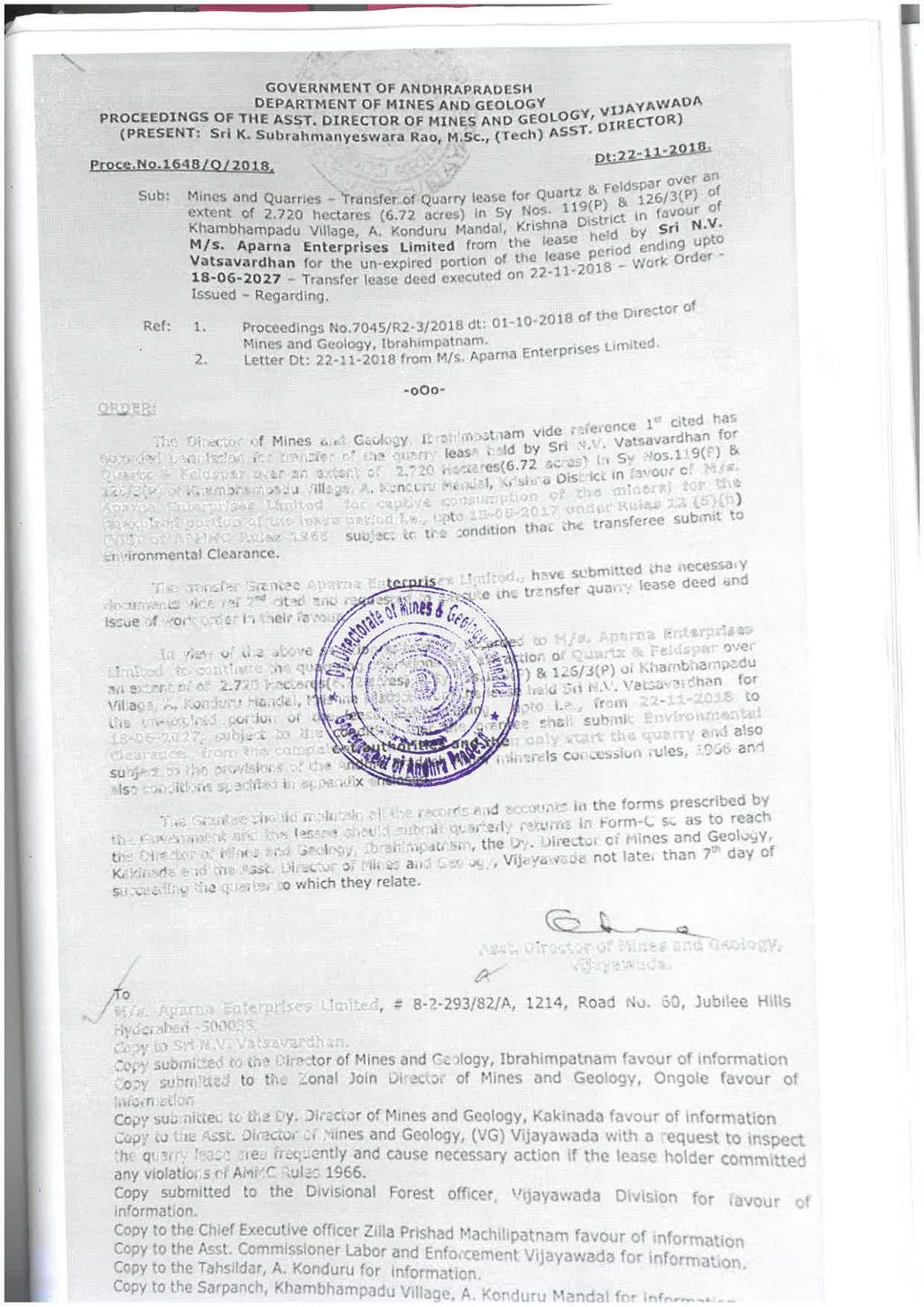
PRE FEASIBILITY REPORT. Quartz and Feldspar Sy No 119 & 126/3, Kambampadu Village A. Konduru Mandal, Krishna District, Andhra Pradesh
|
|
|
- Brianne Wilkins
- 5 years ago
- Views:
Transcription
1


2
3 PRE FEASIBILITY REPORT Of Quartz and Feldspar Sy No 119 & 126/3, Kambampadu Village A. Konduru Mandal, Krishna District, Andhra Pradesh Area of Mining Lease Ha For 1, 09, MT/Annum OF Quartz and Feldspar Production By M/s Aparna Enterprises Limited
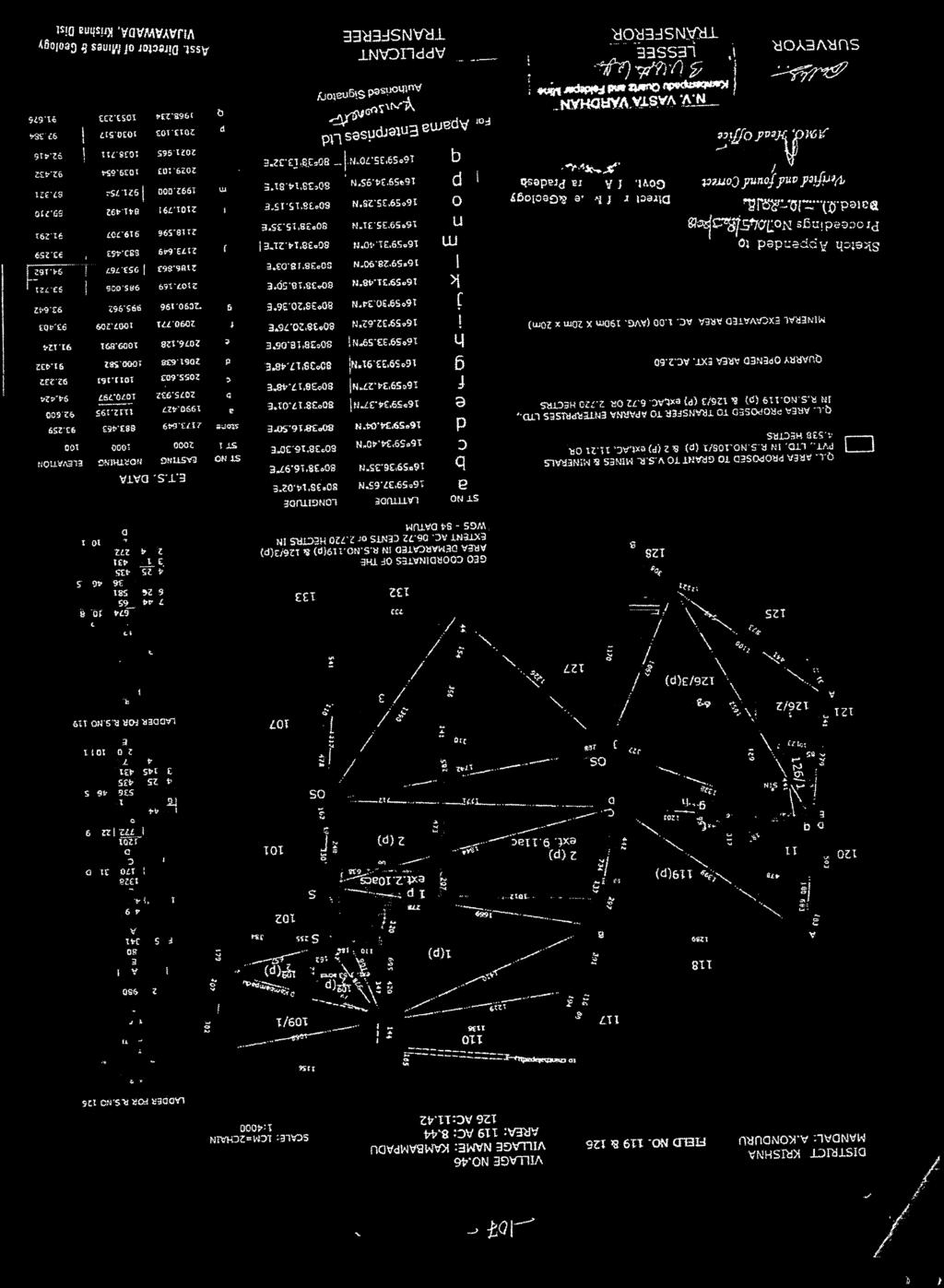
4 EXECUTIVE SUMMARY S. No Parameter Details 1 Name & Address of the Applicant M/s Aparna Enterprises Limited, # /82/A,1214, Road No.60, Jubilee Hills, Hyderabad Mobile No krcreddy@viterotiles.com 2 Total Extent of the Ha project 3 Location of the 119 & 126/3 project 4 Geo Co-ordinates B.P No LATITUDE LONGITUDE a N16 59'37.650" E080 38'14.020" b N16 59'36.350" E080 38'16.970" c N16 59'34.400" E080 38'16.300" d N16 59'34.040" E080 38'16.500" e N16 59'34.370" E080 38'17.010" f N16 59'34.270" E080 38'17.480" g N16 59'33.910" E080 38'17.480" h N16 59'33.590" E080 38'18.060" i N16 59'32.620" E080 38'20.760" j N16 59'30.340" E080 38'20.360" k N16 59'31.480" E080 38'18.500" l N16 59'28.900" E080 38'18.030" m N16 59'31.400" E080 38'14.210" n N16 59'35.310" E080 38'15.350"
5 o N16 59'35.280" E080 38'15.150" p N16 59'34.950" E080 38'14.810" q N16 59'35.700" E080 38'13.320" 5 Total Mineable 6,92, MT Reserves 6 Proposed 1,09, MT -Average annual production Production 7 Life of the Mine 20 years 8 Method of Mining Open Cast Semi Mechanized Method 9 Employment 52 persons 10 Water Requirement 10 KLD 1. INTRODUCTION OF THE PROJECT/BACKGROUND INFORMATION (i) Identification of project and project proponent. In case of mining project, a copy of mining lease/ letter of intent should be given M/s Aparna Enterprises Limited has been granted a quarry lease for Quartz & Feldspar over an extent of Ha in Sy. No s 119 & 126/3 of Kambampadu (V), A. Konduru (M), Krishna District Andhra Pradesh State by Ass Director of Mines & Geology, Vijayawada, Notice No / Q / 2018 dated The copy of the lease letter is enclosed as annexure. (ii) Brief description of the nature of the project The proposed project is a Quartz & Feldspar over an extent of Ha in Sy. No s 119 & 126/3 of Kambampadu (V), A. Konduru (M), Krishna District Andhra Pradesh State, The applicant proposed to produce 1,39,124.3 MT per annum from the subject quarry. (iii) Need for the project & its importance to the country and or region Quartz & Feldspar are used widely in the glass and ceramics industries. Albite, or soda spar as it is known commercially, is used in ceramics. The feldspar-rich rocks larvikite and a few anorthosites are employed as both interior and exterior facing slabs. Quartz & Feldspar has been used for hard stone carvings, sandpapers, sandblasting, and abrasives things. Demand- Supply Gap The Quartz & Feldspar which is produced from the subject Quarry will be used in ceramic and glass industry and used for abrasive mineral. (iv) imports vs. Indigenous production
6 The Quartz & Feldspar will be consumed in the domestic as well as international market (v) Export possibility The Quartz & Feldspar of this area will be sold to the Ferro Alloy Industries, Foundries, Ceramics and to Glass Industries, Located in and around Telangana and Andhra Pradesh. Quartz & Feldspar and Feldspar will be consumed in the domestic as well as international market hence it is export products. (vi) Domestic/Export Markets There is a possibility of Export. The Quartz & Feldspar will be consumed in the domestic and International market also (vii) Employment generation (direct and indirect) due to the project About 52 persons will be employed directly and indirect employment will also be provided I the form of helpers, drivers etc., It will provide employment to the people residing in vicinity. 2. PROJECT DESCRIPTION (i) Type of Project Including Interlinked And Independent Projects, If Any The Subject project is a Quartz & Feldspar Quarry project located over an extent of extent of Ha in Sy. No s 119 & 126/3 of Kambampadu Village, A.konduru Mandal, Krishna District Andhra Pradesh State, The applicant proposed to produce 1,09, MT per annum of the subject quarry. Open Cast Semi Mechanized Method of Mining will be adopted. (ii) Location (map showing general location, specific location, and project boundary & project site layout) with coordinates
 Size or Magnitude of Operation The total extent of the quarry lease area is 2.720 Ha and it is proposed to produce 1,09,055.")
7 (iii) Details of Alternate Sites Considered and the basis of selecting the proposed site, particularly the environmental considerations gone into should be highlighted. No Alternative sites were considered as it is site specific project. (iv) Size or Magnitude of Operation The total extent of the quarry lease area is Ha and it is proposed to produce 1,09, MT per annum from this quarry.
8 Year The year wise production proposed is shown in the following table. YEAR WISE PRODUCTION FOR 4 YEARS (Quartz & Feldspar) Sectional Quartz Feldspar Influence Volume Quartz Feldspar Area T.F. (2.7) T.F. (2.6) (M 2 ) (M) (M 3 R.P (M 3 R.P (M 3 ) Tons Tons Total Volume In T.F. 2 nd Year rd Year th Year th Year , , , , , , , , , , ,10, ,23, Total 53,461 6, , , ,21, ,39, , , ,33, ,48, ,704 37, , ,22,873.6 SUB-TOTAL 1,66,654 29, ,37, , ,57, ,36, AVERAGE 41, , , , , ,09,055.08
9 (v) Project Description with Process Detail (a schematic diagram/ flow chart showing the project layout, components of the project etc. should be given) The Mineral in the quarry lease applied area is proposed to quarry the sheet by Open Cast Semi Mechanized Method by deploying an Excavator will be deployed to slice the mineral vein (from one end to another) and load into trucks. (vi) Demands-Supply Gap The demand for Quartz & Feldspar has been steadily increasing over the years to the requirement of Ferro-silicon, silica refractories, glass and for moulding and casting purposes. The requirements of these products except glass are linked directly with iron & steel industry including alloy steel production. Further, setting up foundries and enhancing their capacities are also linked with metallurgical industry. It is reported that glass industry is expected to grow by 10% every year due to rapid rise in infrastructural activities in the country. At present the domestic market for Quartz & Feldspar crystal components of the annual demand is about 13 ~ 1.6 billion, annual growth rate of nearly 20%. (vii) Availability of Water Its Source, Energy /Power Requirement and Source The total water requirement of the project is 10KLd which will be used for Dust Suppression, Green Belt Development and Domestic Purposes. This water will be sourced from water tankers. (viii) Exploration already carried in the area: Applied area for grant of mining lease was demarcated on the ground with reference to revenue pillars. Later the topographical survey of the area was carried out by ETS. SITE ANALYSIS (i) Connectivity (ii) The location of quarry is well connected with good infrastructure as National Highway connecting to A. Konduru town is at 10 Km away from the quarry and adequate availability of skilled manpower is available for quarry operations.
10 (iii) Land Form, Land Use and Land Ownership The mining lease is located in govt land. The QL applied area is a flat area in the form of Topography along with Map The quarry lease applied area is located on a part of plain land over the clay silty outcrop with a maximum elevation of less than 7 M above ground level within the quarry lease applied area. The lowest contour is 92 M and highest contour is 99 M in topo plan (iv) Soil Classification The soil observed in the area is Clay Sand Soil (v) Climatic Data from Secondary Sources The area is falling under semi-arid tropical zone. The area is having dry climate. The temperature recorded in this area is 25 C in winter and about 48 C in summer seasons. The wind direction is in SW to NE. The average annual rainfall of the area is 1000 mm. (vi) Environmental Requirements: Proper planning of Approach Roads, Crushing Plant with green belt management and water sprinkling of haul roads will achieve hygienic quarry. Closure and Reclamation program shall be strictly implemented after exhaustion of ore in the quarry. (vii) Legal Parameters and Others : The quarry lease is valid up to 20 Years and granted over in Govt. Land. The quarry is under operation without any hindrances, which indicates the public acceptance for quarrying. The quarry is providing an employment for local labour of about 25 members. The quarry authorities / owner has to strictly adhere to future forthcoming any new rules and regulations. The area is not situated in tribal area and any national parks are not situated in the surrounding area.
11
ANNEXURE I Site Location map of M/s. Stone Plus quarry lease A-1
 ANNEXURE I Site Location map of M/s. quarry lease A-1 Quarry Lease boundary map of M/s. A-2 a. Introduction M/s. proposes to conduct semi mechanized open cast method quarrying for Colour granite extraction
Kurnool vide Proceedings No. 712/Q1/2012 dated Ulindakonda Village, Kallur Mandal, Kurnool District,
 1.0 EXECUTIVE SUMMARY 1.1 Introduction The proposed mining area of 1.157Ha. in survey No. 291 of Ulindakonda Village, Kallur Mandal, Kurnool District has been leased to M/s.Sri Lakshmi Sreenivasa Stone
FOR Sand Stone Quarry Village : Chhirraleva Tehsil : Basna District : Mahasamund
 Project Report FOR Sand Stone Quarry at Village : Chhirraleva Tehsil : Basna District : Mahasamund Contents 1. About the Firm... 1 2. Location of the Project... 1 3. Environmental Setting of Project...
FORM -1 MINING PLAN & PRE-FEASIBILITY REPORT FOR QUARRYING OF BLACK GRANITE
 FORM -1 MINING PLAN & PRE-FEASIBILITY REPORT TO OBTAIN ENVIRONMENTAL CLEARANCE FOR QUARRYING OF BLACK GRANITE (Extent 2.3.0Ha)-B2 Project IN S.F.Nos 248/2 (P), 248/1A (P), 248/1B(P) and 248/1C (P) Village
For Sale - 56 Acre Sandstone Quarry State Route 511, Oberlin/Kipton, OH 44075
 14647 State Route 511, Oberlin/Kipton, OH 44075 56 ACRES Vermilion Rd Gifford Rd Haigh Rd 44 Summary The Kipton sandstone quarry is included in 56 acre tract owned by Terry A. Johnson, of Huron, Ohio.
EMP. In respect of. Cluster of Two Mines (Cluster area Ha)
") M/s. NSC Consortium, Road Metal Mine 12.146 Ha. EMP In respect of Cluster of Two Mines (Cluster area 22.146 Ha) AT Sy. No. 734/P, Yadavalli Village, Dornala Mandal, Prakasam district, Andhra Pradesh Cluster
M/s. NSC Consortium, Road Metal Mine 12.146 Ha. EMP In respect of Cluster of Two Mines (Cluster area 22.146 Ha) AT Sy. No. 734/P, Yadavalli Village, Dornala Mandal, Prakasam district, Andhra Pradesh Cluster
Research and Reviews: Journal of Ecology and Environmental Sciences
 Research and Reviews: Journal of Ecology and Environmental Sciences e-issn: 2347-7830 Quality Assessment of Quartz in Kukatpally, Ranga Reddy District, Telangana, India. J Vijay Kumar and B Linda Prabhakar
SRI E.DEVARAJULU, S/O.E.Ramachandra Naidu, D.No: 26-39, Palamaner Road,Kajur, Chittoor (District), Andhara Pradesh State. Contact No:
, Andhara Pradesh State. Contact No:") MINING SCHEME FOR BLACK GRANITE OVER AN EXTENT OF 1.800Hects. IN Sy.No. 1406 OF VAVILTHOTA(V), PUTHALAPATTU (M), CHITTOOR (Dist) A.P (Under Rule 18(2) of GCDR 1999) BLOCK PERIOD 2015-16 TO 2021-22 BALANCE
MINING SCHEME FOR BLACK GRANITE OVER AN EXTENT OF 1.800Hects. IN Sy.No. 1406 OF VAVILTHOTA(V), PUTHALAPATTU (M), CHITTOOR (Dist) A.P (Under Rule 18(2) of GCDR 1999) BLOCK PERIOD 2015-16 TO 2021-22 BALANCE
FOR QUARRYING OF KAGANAM ROUGH STONE AND GRAVEL QUARRY
 PROPOSAL TO OBTAIN ENVIRONMENTAL CLEARANCE FROM District Level Environment Impact Assessment Authority (DEIAA), Tiruvannamalai District, Tamilnadu FOR QUARRYING OF KAGANAM ROUGH STONE AND GRAVEL QUARRY
Granite Building Stone Quarry of Sri. Sajan Mani.
 1. EXECUTIVE SUMMARY: Sri. Sajan Mani had made an application for Granite building stone quarrying located in Sy. No. 2398, Peechi Village, Thrissur Taluk, Thrissur District, Kerala State. Over an extent
PRE-FEASIBILITY REPORT VASAI LIMESTONE MINE (APPLICANT: SHRI KHERAJBHA KARUBHA KER)
") PRE-FEASIBILITY REPORT OF VASAI LIMESTONE MINE (APPLICANT: SHRI KHERAJBHA KARUBHA KER) 1. EXECUTIVE SUMMARY: The existing Mining lease for mineral Limestone over 4.9000 Hectares for a period of thirty
PRE-FEASIBILITY REPORT OF VASAI LIMESTONE MINE (APPLICANT: SHRI KHERAJBHA KARUBHA KER) 1. EXECUTIVE SUMMARY: The existing Mining lease for mineral Limestone over 4.9000 Hectares for a period of thirty
FORM -1 MINING PLAN & PRE-FEASIBILITY REPORT
 FORM -1 MINING PLAN & PRE-FEASIBILITY REPORT TO OBTAIN ENVIRONMENTAL CLEARANCE FOR QUARRYING OF ROUGH STONE (Extent 1.91.5Ha)-B2 Project IN S.F.No 1257/1 Village Nagamangalam Taluk Denkanikottai District
Lessee. Sri.B.Srinivasa Rao S/o Seetha Ramaiah D.No:6-122/1 Guntupalli Village Ibrahimpatnam Mandal Krishna Dist.
 MINING PLAN INCLUDING PROGRESSIVE MINE CLOSURE PLAN FOR ROAD METAL (Under Rule 7 A of APMMC Rules 1966 & Rule 23 (B) of MCDR 1988) (FOR THE PLAN PERIOD 2017 18 TO 2021 22) Over an extent of 2.024 Hectares
Geology and the Aggregate Industry: The Role of Geologists
 Geology and the Aggregate Industry: The Role of Geologists Donald G. Mikulic Illinois State Geological Survey Prairie Research Institute University of Illinois at Urbana-Champaign Outline Importance of
lit)'*'" m ( Reft- Representation received from M/s. Kasturi Granites and Exports, Proprietor Smt. C. Kasturibai Dated:
'*' m ( Reft- Representation received from M/s. Kasturi Granites and Exports, Proprietor Smt. C. Kasturibai Dated:") Lr.No.233 /QlzOrL GOVERNMENT OF ANDHRA PRADESH DEPARTMENT OF MINES & GEOLOGY D Dated: 7.03.2018 From Sri G. Shivaji, M.Sc., Tech.,, Asst. Director of Mines and Geology (FACJ, Srikakulam. To The SEIAA Govt.
Lr.No.233 /QlzOrL GOVERNMENT OF ANDHRA PRADESH DEPARTMENT OF MINES & GEOLOGY D Dated: 7.03.2018 From Sri G. Shivaji, M.Sc., Tech.,, Asst. Director of Mines and Geology (FACJ, Srikakulam. To The SEIAA Govt.
APPLICANT: M/s. Rock Sand & Minerals Pvt Ltd PRE-FEASIBILITY REPORT
 PRE- FEASIBILITY REPORT 1.1 Introduction EXECUTIVE SUMMARY The proposed mining lease of 19.80ha in survey no. 345 was granted to M/s. Rock Sand Minerals Pvt Ltd, for a period of 15 years by Asst. Director
Granite Building Stone Quarry of M/s Ulikkal Stone Crusher
 1. EXECUTIVE SUMMARY: M/s. Ulikkal Stone Crusher had made an application for Granite building stones quarrying located in Sy. No. 28/1A2 in Vayathur Village, Iritty taluk, Kannur District, Kerals State.
Of Sri. Mohammad Akram. At Karigala Village, H.D. KoteTaluk, Mysore District, Karnataka Latitude & Longitude Piller Latitude Longitude Coordinates
 1.0 EXECUTIVE SUMMARY 1.1 Introduction The proposed mining lease area applied for quarrying of Steatite Stone (soap stone) by Sri. Mohammad Akramis situated in survey no. No. 402of 1-30 Acres of Karigala
Report for Area Drainage Studies for 1320 MW (2x660 MW) THERMAL POWER PROJECT AT MIRZAPUR, U.P.
 THERMAL POWER PROJECT AT MIRZAPUR, U.P.") Report for Area Drainage Studies for 1320 MW (2x660 MW) THERMAL POWER PROJECT AT MIRZAPUR, U.P. 1. Introduction M/s Welspun Energy Uttar Pradesh Ltd. (WEUPL) is putting up 1320 MW (2 x 660 MW) coal fired
Report for Area Drainage Studies for 1320 MW (2x660 MW) THERMAL POWER PROJECT AT MIRZAPUR, U.P. 1. Introduction M/s Welspun Energy Uttar Pradesh Ltd. (WEUPL) is putting up 1320 MW (2 x 660 MW) coal fired
SRI E.DEVARAJULU, S/O.E.Ramachandra Naidu, D.No: 26-39, Palamaner Road,Kajur, Chittoor (District), Andhara Pradesh State. Contact No:
, Andhara Pradesh State. Contact No:") MINING SCHEME FOR BLACK GRANITE OVER AN EXTENT OF 1.500Hects. IN Sy.No. 1406 OF VAVILTHOTA(V), PUTHALAPATTU (M), CHITTOOR (Dist) A.P (Under Rule 18(2) of GCDR 1999) 1st SCHEME PERIOD 2017-18 TO 2021-22
MINING SCHEME FOR BLACK GRANITE OVER AN EXTENT OF 1.500Hects. IN Sy.No. 1406 OF VAVILTHOTA(V), PUTHALAPATTU (M), CHITTOOR (Dist) A.P (Under Rule 18(2) of GCDR 1999) 1st SCHEME PERIOD 2017-18 TO 2021-22
APPLICANT: MD. SARFARAZ ANSARI & VIVEKA NAND RAY PRE FEASIBILITY REPORT PRE- FEASIBILITY REPORT
 PRE- FEASIBILITY REPORT 0 CONTENTS EXECUTIVE SUMMARY... 3 1.0 INTRODUCTION... 3 1.1 SALIENT FEATURES OF THE PROJECT... 4 1.2 PRESENT LAND USE PLAN... 5 1.3 PROPOSED PLANNING... 5 1.4 UTILIZATION... 5 2.
ENVIRONMENTAL MANAGEMENT (CLUSTER)
") /+ ENVIRONMENTAL MANAGEMENT (CLUSTER) PLAN Of M/s. APARNA ENTERPRISES LIMITED MINING OF QUARTZ & FELDSPAR OVER AN EXTENT: 2.720 HA Mine Address: Sy. No.119 & 126/3 Khambhampadu (V), A.konduru (M) Krishna
/+ ENVIRONMENTAL MANAGEMENT (CLUSTER) PLAN Of M/s. APARNA ENTERPRISES LIMITED MINING OF QUARTZ & FELDSPAR OVER AN EXTENT: 2.720 HA Mine Address: Sy. No.119 & 126/3 Khambhampadu (V), A.konduru (M) Krishna
WHAT IS A ROCK? Granite. Muscovite. Orthoclase. Quartz. Feldspar. Biotite
 Mining, Jobs October 2014 WHAT IS A ROCK? A ROCK IS DEFINED AS AN COMBINATION OF ONE OR MORE MINERALS. Granite Orthoclase Muscovite Feldspar Quartz Biotite What Makes One Rock Better than Another Rock?
MAPS AND THEIR CLASSIFICATION
 MAPPING MAPS AND THEIR CLASSIFICATION WHAT IS A MAP? A map is representation of the Earth's surface, showing how things are related to each other by distance, direction, and size. Maps are a way of showing
IRUNGU PETER WACHIRA I13/3135/2008
 IRUNGU PETER WACHIRA I13/3135/2008 Statement of the problem Objectives Study area Geology Materials and methods Data results and analysis Extraction mining and processing Uses and applications Recommendations
5.11 MINERAL RESOURCES
 5.11 This section of the Draft PEIR evaluates the potential impacts to mineral resources in the Plan Area from implementation of the Clovis General Plan and Development Code Update (proposed project).
THE MINISTRY OF ENERGY AND ENERGY INDUSTRIES MINERALS DIVISION MINE DESIGN TEMPLATE OPERATOR NAME: OPERATOR ADDRESS: PHONE NUMBER: FACSIMILE:
 THE MINISTRY OF ENERGY AND ENERGY INDUSTRIES MINERALS DIVISION MINE DESIGN TEMPLATE 1.0 GENERAL INFORMATION OPERATOR NAME: OPERATOR ADDRESS: PHONE NUMBER: FACSIMILE: NAME OF CONTACT: CELLULAR PHONE: EMAIL
TABLE 1: Salient features of the project. Black Granite Mine of Sri D. Rama Rao GCP LATITUDE (N) LONGITUDE (E)
 LONGITUDE (E)") 1. EXECUTIVE SUMMARY 1.1 Introduction The proposed mining lease area of Black Granite over an extent of 1.205 Ha. is located in Sy. No. 99/1B of Gurijepalli Village, Santhamaguluru Mandal, Prakasam District,
1. EXECUTIVE SUMMARY 1.1 Introduction The proposed mining lease area of Black Granite over an extent of 1.205 Ha. is located in Sy. No. 99/1B of Gurijepalli Village, Santhamaguluru Mandal, Prakasam District,
TABLE OF CONTENTS. 1.0 Introduction. 2.0 Geology, Exploration and Reserves. 3.0 Mining. 4.0 Blasting. 5.0 Mine Drainage. 6.
 TABLE OF CONTENTS 1.0 Introduction 2.0 Geology, Exploration and Reserves 3.0 Mining 4.0 Blasting 5.0 Mine Drainage 6.0 Site Services 1.0 INTRODUCTION Pankaj Chandrakar a resident oftemri, P.O. Deopuri
ANNEXURE-I (AS PER FORMAT ISSUED BY BIHAR-SEIAA)
") ANNEXURE-I (AS PER FORMAT ISSUED BY BIHAR-SEIAA) ANNEXURE-II (AS PER FORMAT ISSUED BY BIHAR-SEIAA) ANNEXURE-III LETTER OF INTENT Scanned by CamScanner Scanned by CamScanner Scanned by CamScanner
ANNEXURE-I (AS PER FORMAT ISSUED BY BIHAR-SEIAA) ANNEXURE-II (AS PER FORMAT ISSUED BY BIHAR-SEIAA) ANNEXURE-III LETTER OF INTENT Scanned by CamScanner Scanned by CamScanner Scanned by CamScanner
PRE FEASIBILITY REPORT OF QUARTZ & FELDSPAR MINING PROJECT (ML No- 80/03) FOR TERMS OF REFERENCE
 FOR TERMS OF REFERENCE") PRE FEASIBILITY REPORT OF QUARTZ & FELDSPAR MINING PROJECT (ML No- 80/03) FOR TERMS OF REFERENCE Village Ashapura Tehsil Nasirabad District Ajmer State Rajasthan Capacity 35945 TPA ROM (Max) Lease Area
PRE FEASIBILITY REPORT OF QUARTZ & FELDSPAR MINING PROJECT (ML No- 80/03) FOR TERMS OF REFERENCE Village Ashapura Tehsil Nasirabad District Ajmer State Rajasthan Capacity 35945 TPA ROM (Max) Lease Area
LANDSLIDE SUSCEPTIBILITY MAPPING USING INFO VALUE METHOD BASED ON GIS
 LANDSLIDE SUSCEPTIBILITY MAPPING USING INFO VALUE METHOD BASED ON GIS ABSTRACT 1 Sonia Sharma, 2 Mitali Gupta and 3 Robin Mahajan 1,2,3 Assistant Professor, AP Goyal Shimla University Email: sonia23790@gmail.com
MCDR INSPECTION General. Date of Inspection Name of the Mine Bhatbhera Limestone Mine 2 Total Lease Area (Ha)
") ::1:: MCDR INSPECTION General SN Particulars Details Date of Inspection 23.8.2015 1 Name of the Mine Bhatbhera Limestone Mine 2 Total Lease Area (Ha) 4.808 Hect (Govt. Revenue Land), Non-forest land with
::1:: MCDR INSPECTION General SN Particulars Details Date of Inspection 23.8.2015 1 Name of the Mine Bhatbhera Limestone Mine 2 Total Lease Area (Ha) 4.808 Hect (Govt. Revenue Land), Non-forest land with
PRE FEASIBILITY REPORT. Kuppilli, Koyyam, Dharmavaram, Village Bonthalakoduru villages Mandal Etcherla District Srikakulam State Andhra Pradesh
 1) Executive Summary Project Name of Company / Mine Owner Location PRE FEASIBILITY REPORT Kuppli- Koyyam Mineral Sands Deposit-I, Pre-concentration Plant (PCP). M/s. Andhra Pradesh Mineral Development
KRISHNA MERCHANTS PVT. LTD.
 (Color Granite Quarry lease area 15.00 Ha. Sy. No.1) ADDUKONDA VILLAGE TEKKALI MANDAL SRIKAKULAM DISTRICT ANDHRA PRADESH ENVIRONMENTAL MANAGEMENT PLAN PREPARED BY 6-3-652 Flat # 7-3 Dhruvatara Apartments
SIXTH SCHEDULE REPUBLIC OF SOUTH SUDAN MINISTRY OF PETROLEUM, MINING THE MINING (MINERAL TITLE) REGULATIONS 2015
 REGULATIONS 2015") SIXTH SCHEDULE REPUBLIC OF SOUTH SUDAN MINISTRY OF PETROLEUM, MINING THE MINING ACT, 2012 THE MINING (MINERAL TITLE) REGULATIONS 2015 Guidelines should be prepared by the Directorate of Mineral Development
SIXTH SCHEDULE REPUBLIC OF SOUTH SUDAN MINISTRY OF PETROLEUM, MINING THE MINING ACT, 2012 THE MINING (MINERAL TITLE) REGULATIONS 2015 Guidelines should be prepared by the Directorate of Mineral Development
C. SHASHI KUMAR. Mine lease area Ha. in Sy. No. 120/1, Mailaram Village, Balmoor Mandal, Nagarkurnool District, Telangana
 C. SHASHI KUMAR Mine lease area 24.28 Ha. in Sy. No. 120/1, Mailaram Village, Balmoor Mandal, Nagarkurnool District, Telangana ENVIRONMENTAL MANAGEMENT PLAN PREPARED BY ISO 9001: 2008 Certified Accredited
Meghalaya. Mining their own business. Arwat Challam
 Meghalaya Mining their own business Arwat Challam Introduction Area of 22,429 sq. km. Divided into 7 Districts Meghalaya Three Main tribes- Khasi, Pnar and Garo Indo-Malayan Biodiversity Hotspot. Major
Over an extent of Hectares in Sy. No. 01 of Kachavaram (V), Ibrahimpatnam (M), Krishna District, Andhra Pradesh State
, Ibrahimpatnam (M), Krishna District, Andhra Pradesh State") MINING PLAN INCLUDING PROGRESSIVE MINE CLOSURE PLAN FOR ROAD METAL & GRAVEL (Under Rule 7 A of APMMC Rules 1966 & Rule 23 (B) of MCDR 1988) INTRODUCTION Over an extent of 0.810 Hectares in Sy. No. 01 of
MINING PLAN INCLUDING PROGRESSIVE MINE CLOSURE PLAN FOR ROAD METAL & GRAVEL (Under Rule 7 A of APMMC Rules 1966 & Rule 23 (B) of MCDR 1988) INTRODUCTION Over an extent of 0.810 Hectares in Sy. No. 01 of
ENVIRONMENTAL MANAGEMENT PLAN
 ENVIRONMENTAL MANAGEMENT PLAN Of GRAVEL & BUILDING STONE QUARRY For Sri Prathipati. Ram Prasad 1.235 HA GRAVEL & BUILDING STONE QUARRY SY. NO. 860, Vedurupavuluru (V), Gannavaram(M), Krishna(DT), ANDHRA
Geological Report on Limestone Exploration Of Bhatvadiya B Block Of EXECUTIVE SUMMARY
 Geological Report on Limestone Exploration Of Bhatvadiya B Block Of Kalyanpur Taluka, Devbhumi Dwarka District, Gujarat EXECUTIVE SUMMARY Prepared for: Gujarat Mineral Research & Development Society Government
O and Si make up % of all atoms available to make minerals in the Earth's crust.
 7. Minerals III (p. 87-97) Mineral Families O and Si make up % of all atoms available to make minerals in the Earth's crust. Minerals in which cations combine with O 2- anions are called. If Si gets added,
INDEX. Environmental Management Plan
 Environmental Management Plan M/s. N.V. Exports [Quarry Lease Area - 0.615 Ha.( 1.52 Acres)] Sy. No. : 11/1 Village : R.L. Puram Mandal : Chimakurthy District : Prakasam State : Andhra Pradesh ENVIRONMENTAL
Over an extent of 9.28 Acres in Sy. No. 72 / P of Jangameswarapuram (V), Martur (M), Prakasam District, Andhra Pradesh State
, Martur (M), Prakasam District, Andhra Pradesh State") MINING PLAN INCLUDING PROGRESSIVE MINE CLOSURE PLAN FOR ROAD METAL (Under Rule 7 A of APMMC Rules 1966 & Rule 23 (B) of MCDR 1988) (FOR THE PLAN PERIOD 2014 15 TO 2018 19) (FOR THE ENSUING BALANCE 2 YEARS
MINING PLAN INCLUDING PROGRESSIVE MINE CLOSURE PLAN FOR ROAD METAL (Under Rule 7 A of APMMC Rules 1966 & Rule 23 (B) of MCDR 1988) (FOR THE PLAN PERIOD 2014 15 TO 2018 19) (FOR THE ENSUING BALANCE 2 YEARS
Hope Brook gold mine, NL - Copper, then switched to gold
 Chapter 12 : Mining in NL Defined as the extraction of valuable minerals from Earth from an ore body, vein, or seam. A mineral is any chemical substance arranged in some crystalline structure. - must have
PW 001 SNOW REMOVAL AND SANDING FOR ROADWAYS AND SIDEWALKS October 6, 2014 (#223-14) Original October 19, 2015; October 15, 2018 Public Works
 Original October 19, 2015; October 15, 2018 Public Works") Policy Statement: The Village of Kitscoty will provide snow and ice control on municipal streets and sidewalks according to determined priorities. Purpose: To provide direction and information to employees
Policy Statement: The Village of Kitscoty will provide snow and ice control on municipal streets and sidewalks according to determined priorities. Purpose: To provide direction and information to employees
MCDR INSPECTION REPORT
 MCDR INSPECTION REPORT General S. N. Particulars Details 1 Name of the Mine Matia Limestone Mine 2 Total Lease Area (Ha) with breakup of Non-forest and forest 12.137 Ha. land 3 Mine code 38CHG14086 4 IBM
GROUNDWATER CONFIGURATION IN THE UPPER CATCHMENT OF MEGHADRIGEDDA RESERVOIR, VISAKHAPATNAM DISTRICT, ANDHRA PRADESH
 GROUNDWATER CONFIGURATION IN THE UPPER CATCHMENT OF MEGHADRIGEDDA RESERVOIR, VISAKHAPATNAM DISTRICT, ANDHRA PRADESH Prof.P.Jagadeesara Rao Department of Geo-Engineering and Centre for Remote Sensing, College
PRE - FEASIBILITY REPORT Shri Santosh Kumar Dwivedi S/o Shri Goverdhan Dwivedi R/o Village Adampur Saibasi Majre
 1. EXECUTIVE SUMMARY PRE - FEASIBILITY REPORT Shri Santosh Kumar Dwivedi S/o Shri Goverdhan Dwivedi R/o Village Adampur Saibasi Majre Sarkandi, Tehsil and District - Fatehpur, Uttar Pradesh is the lessee
HISTORY & GEOGRAPHY 702 (NEW EDITION)
") Geography CONTENTS Introduction.......................................................... 2 Curriculum Outline.................................................... 3 HISTORY & GEOGRAPHY 702 (NEW EDITION)
Geography CONTENTS Introduction.......................................................... 2 Curriculum Outline.................................................... 3 HISTORY & GEOGRAPHY 702 (NEW EDITION)
MCDR INSPECTION REPORT
 MCDR INSPECTION REPORT General S. N. Particulars Details 1 Name of the Mine Matia Limestone Mine 2 Total Lease Area (Ha) with breakup of Non-forest and forest 8.144 ha.,non forest land land 3 Mine code
Geography Class XI Fundamentals of Physical Geography Section A Total Periods : 140 Total Marks : 70. Periods Topic Subject Matter Geographical Skills
 Geography Class XI Fundamentals of Physical Geography Section A Total Periods : 140 Total Marks : 70 Sr. No. 01 Periods Topic Subject Matter Geographical Skills Nature and Scope Definition, nature, i)
Silver City Minerals
 ABN 68 130 933 309 ASX Code: SCI Silver City Minerals Annual General Meeting 15 November 2016 1 Important Disclaimer This presentation is provided to you for the sole purpose of providing background technical,
MAP STUDY: INTERPRETATION OF SURVEY MAPS
 MAP STUDY: INTERPRETATION OF SURVEY MAPS Types and Elements of Maps Maps are drawn to represent the Earth on a piece of paper. Maps are used widely to represent the Earth. Maps use signs and symbols in
5. Environmental Analysis
 5.9 MINERAL RESOURCES 5.9.1 Methodology The California Geological Survey Mineral Resources Project provides information about California s nonfuel mineral resources. The primary focus of the Mineral Resources
City of Laramie, Wyoming SNOW AND ICE POLICY
 City of Laramie, Wyoming SNOW AND ICE POLICY 11/02/89; rev 10/15/2007 I. INTRODUCTION The intention of this Policy is to set reasonable goals and general practices as a guide for the conduct of snow and
Investigation of Rainfall Trend in Jorhat Town, Assam, India
 EUROPEAN ACADEMIC RESEARCH Vol. II, Issue 7/ October 2014 ISSN 2286-4822 www.euacademic.org Impact Factor: 3.1 (UIF) DRJI Value: 5.9 (B+) Investigation of Rainfall Trend in Jorhat Town, MAYURAKSHI BHUYAN
Smt. M. Hari Chandana
 Smt. M. Hari Chandana Quarry lease area 11.201 Ha. (27.68 Acres) in Sy. No. 22, Kudavanandapur Village, Raikode Mandal, Sangareddy District, Telangana CLUSTER ENVIRONMENTAL MANAGEMENT PLAN PREPARED BY
GOVERNMENT OF MADHYA PRADESH WATER RESOURCES DEPARTMENT HANOTA MAJOR PROJECT PRE FEASIBILITY REPORT. ESTIMATED COST : Rs
 GOVERNMENT OF MADHYA PRADESH WATER RESOURCES DEPARTMENT HANOTA MAJOR PROJECT PRE FEASIBILITY REPORT ESTIMATED COST : Rs. 1392.42 Crores DESIGNED IRRIGATION : 40000 Ha. COST PER HACT. : Rs. 3.48 Lakhs ''EVERY
UNIT 11 SOUTH ASIA SG 1 - PHYSICAL GEOGRAPHY & THE ENVIRONMENT
 UNIT 11 SOUTH ASIA SG 1 - PHYSICAL GEOGRAPHY & THE ENVIRONMENT I. PHYSICAL GEOGRAPHY TAKE OUT YOUR PHYSICAL MAP OF SOUTH ASIA A. The Himalayan Mountains form the northern boundary of the region (color
Unit 7.2 W.E.D. & Topography Test
 Name: Score: Unit 7.2 W.E.D. & Topography Test 1. 2. 3. 4. 5. 6. 7. 8. 9. 10. 11. 12. 13. 14. 15. 16. 17. 18. 19. 20. 21. 22. 23. 24. 25. 1. The formation of mountains is due mainly to while the destruction
JAI MAA SHARDA STONE CRUSHING
 JAI MAA SHARDA STONE CRUSHING Prop. Hukum Singh (M. No. 9425585252) Near-Pahunadukan Kedarpur Ambikapur, (C.G.) To, The Member Secretary, SLEIAA(State Level Environment Impact Assessment Authority), Ministry
MINING PLAN FORMAT (A & B CATEGORY MINES) As per MCDR,1988
 As per MCDR,1988") MINING PLAN FORMAT (A & B CATEGORY MINES) As per MCDR,988 INTRODUCTORY NOTES. 'A' category mines : all mines excluding 'B' Category mines. B' category mines : all 'B' Category mines excluding very small
MINING PLAN FORMAT (A & B CATEGORY MINES) As per MCDR,988 INTRODUCTORY NOTES. 'A' category mines : all mines excluding 'B' Category mines. B' category mines : all 'B' Category mines excluding very small
Geological report on Limestone Exploration of Goyla Block, Abadasa Taluka, Kachchh District, Gujarat. Executive Summary
 Geological report on Limestone Exploration of Goyla Block, Abadasa Taluka, Kachchh District, Gujarat Executive Summary Prepared for Commissioner of Geology & Mining Government of Gujarat Prepared by Geovale
M/s BENITA INDUSTRIES LIMITED
 M/s BENITA INDUSTRIES LIMITED (Colour Granite Quarry 19.150 Ha.) Sy. No: 82-1 of Kambadur (V), Kambadur (M), Ananthapur District, Andhra Pradesh State. ENVIRONMENTAL MANAGEMENT PLAN 0 P a g e INDEX S.
The role of the Competent Person. Neil Wells, CRIRSCO Deputy Chair, Yogyakarta, 31 October 2017
 The role of the Competent Person Neil Wells, CRIRSCO Deputy Chair, Yogyakarta, 31 October 2017 Why are Competent Persons needed for reporting? Mineral commodities and occurrences are diverse Copper (disseminated,
MCDR INSPECTION REPORT. S. N. Particulars Details 1 Name of the Mine, Inspecting officer with Designation, Date of Inspection
 MCDR INSPECTION REPORT General S. N. Particulars Details 1 Name of the Mine, Inspecting officer with Designation, Date of Inspection Bharuadih Limestone Mine,Rajesh Kumar Das,Sr.ACOM,18.08.2017 2 Total
D D Matyanga Mineral Economist and Technical Advisor
 D D Matyanga Mineral Economist and Technical Advisor } Coal resources in Zimbabwe } Coal production historical perspective } Future of coal production } Significance of coal to the Economy Employment Exports
QUARRY PLAN FOR LIMESTONE SLABS
 QUARRY PLAN FOR LIMESTONE SLABS (Under Rule 7 B of TSMMC Rules, 1966) INCLUDING PROGRESSIVE QUARRY CLOSURE PLAN (Under Rule 7 B (viii) of TSMMC Rules, 1966) (FOR THE PLAN PERIOD 2016 17 TO 2020 21) (FOR
SITE SELECTION CRITERIA FOR A SOLAR PV PLANT. Under The Guidence of SOHEL PATEL
 SITE SELECTION CRITERIA FOR A SOLAR PV PLANT Under The Guidence of SOHEL PATEL CONTENTS Introduction Selection of land 1.area longitude & latitude 2.quality of soil 3.soil test report 4.Terrain & contours
The following Environmental Management Programme (EMP) was also approved in terms of the issuing of the above-mentioned mining right:
 was also approved in terms of the issuing of the above-mentioned mining right:") 1. INTRODUCTION Belfast Silica Mine is located on the Remaining Extent of Portion 1 of the farm Klipfontein 385 JS, which is situated approximately 8 km north west of Belfast and Siyathuthuka (Figure 2.1).
1. INTRODUCTION Belfast Silica Mine is located on the Remaining Extent of Portion 1 of the farm Klipfontein 385 JS, which is situated approximately 8 km north west of Belfast and Siyathuthuka (Figure 2.1).
INDIAN BUREAU OF MINES MINERALS DEVELOPMEMT AND REGULATION DIVISION MCDR INSPECTION REPORT. Chennai regional office
 1. Mine file No : (i) Name of the Inspecting : Officer and ID No. INDIAN BUREAU OF MINES MINERALS DEVELOPMEMT AND REGULATION DIVISION TN/TCR/LST-1, MDS (ii) Designation : (iii) Accompaning mine : Official
Tell me what the word aggregate means and at least three things aggregate is used to make.
 Lesson Plan Scout s Geology Objective: After today s lesson, you will be able to Tell me what the word aggregate means and at least three things aggregate is used to make. List the steps in the mining
Over an extent of 1.36 Hectares in Sy. No. 60 / 33 Vennaram (V), Dornakal (M), Mahabubabad District, Telangana State
, Dornakal (M), Mahabubabad District, Telangana State") SECOND SCHEME OF QUARRYING FOR BLACK GRANITE Extent : 1.36 Hectares 2019 SECOND SCHEME OF QUARRYING FOR BLACK GRANITE (Under Rule 7 B of TSMMC Rules, 1966) INCLUDING PROGRESSIVE QUARRY CLOSURE PLAN (Under
SECOND SCHEME OF QUARRYING FOR BLACK GRANITE Extent : 1.36 Hectares 2019 SECOND SCHEME OF QUARRYING FOR BLACK GRANITE (Under Rule 7 B of TSMMC Rules, 1966) INCLUDING PROGRESSIVE QUARRY CLOSURE PLAN (Under
About places and/or important events Landmarks Maps How the land is, hills or flat or mountain range Connected to maps World Different countries
 What do you think you know about geography? About places and/or important events Landmarks Maps How the land is, hills or flat or mountain range Connected to maps World Different countries What do you
Submitted to: Central Coalfields Limited Ranchi, Jharkhand. Ashoka & Piparwar OCPs, CCL
 Land Restoration / Reclamation Monitoring of more than 5 million cu. m. (Coal + OB) Capacity Open Cast Coal Mines of Central Coalfields Limited Based on Satellite Data for the Year 2013 Ashoka & Piparwar
Nursery. Reception. Year 1
 Nursery Geography Overview Autumn Spring Summer Notices detailed features of objects in their environment. Comments and asks questions about aspects of their familiar world such as the place where they
Guidelines for preparation of Mining Plans for Coal/Lignite Blocks
 Guidelines for preparation of Mining Plans for Coal/Lignite Blocks Annexure The following guidelines are issued for preparation of mining plans for coal/lignite block development by the block holders.
[Penumaka, 7(1): January-March 2017] ISSN Impact Factor
![[Penumaka, 7(1): January-March 2017] ISSN Impact Factor](/thumbs/95/124653515.jpg "[Penumaka, 7(1): January-March 2017] ISSN Impact Factor") INTERNATIONAL JOURNAL OF ENGINEERING SCIENCES &MANAGEMENT HYDROGEOMORPHOLOGY OF CHEVELLA BASIN, RANGA REDDY DISTRICT, TELANGANA STATE Penumaka Ramesh* 1 & Podila Sankara Pitchaiah 2 * 1&2 Department of
INTERNATIONAL JOURNAL OF ENGINEERING SCIENCES &MANAGEMENT HYDROGEOMORPHOLOGY OF CHEVELLA BASIN, RANGA REDDY DISTRICT, TELANGANA STATE Penumaka Ramesh* 1 & Podila Sankara Pitchaiah 2 * 1&2 Department of
SCRUTINY COMMENTS ON DRAFT REVIEW OF MINING PLAN IN RESPECT OF GHATKURI IRON ORE MINE (149. A. TEXT:
 Annexure SCRUTINY COMMENTS ON DRAFT REVIEW OF MINING PLAN IN RESPECT OF GHATKURI IRON ORE MINE (149.7343 HA) OF M/S NIRMAL KUMAR PRADEEP KUMAR IN GHATKURI AND KARAMPADA RESERVE FOREST DISTICT WEST SINGBHUM
data becomes available to us. We already have crude maps of the Mars and the Moon. A map gives a picture of one or several of the elements of the
 FUNDAMENTALS OF MAPS THE SPHERICAL earth is best represented bya three-dimensional model of the earth, called a globe. All parts of the earth can be shown on it in their true shape, area and location along
Practice Questions for Lecture 5 Geology 1200
 Practice Questions for Lecture 5 Geology 1200 Use these questions to test your knowledge of Lecture5. The exams will be similar in format, except that they will deal with more than one chapter, and will
Geo-hazard Potential Mapping Using GIS and Artificial Intelligence
 Geo-hazard Potential Mapping Using GIS and Artificial Intelligence Theoretical Background and Uses Case from Namibia Andreas Knobloch 1, Dr Andreas Barth 1, Ellen Dickmayer 1, Israel Hasheela 2, Andreas
GENERAL EDUCATION AND TRAINING SOCIAL SCIENCES
 GENERAL EDUCATION AND TRAINING SOCIAL SCIENCES GEOGRAPHY PAPER 1 FINAL EXAMINATION NOVEMBER 2014 GRADE 8 MARKS: 50 DURATION : 1 HOUR SOCIAL SCIENCES GEOGRAPHY GRADE 8 NOVEMBER 2014 TIME: 90 MINUTES TOTAL:
Grade Five Social Studies Assessment Regions/Native Americans
 Name Grade Five Social Studies Assessment Regions/Native Americans Use the map below to answer questions 1 and 2 1. (Geo 1) For this location give the name of the city found there. 38 N, 100 W a. Scottsbluff
PRE-FEASIBILITY REPORT
 PRE-FEASIBILITY REPORT (Under the Guidelines of Ministry of Environment and Forest in terms of the provisions of EIA notification 2006 and specifically in circular No J-11013/41/2006-IA.II (I) dated 30
Environmental Science Institute The University of Texas - Austin
 Environmental Science Institute The University of Texas - Austin Geologic Wonders of Central Texas Dr. Leon Long This file contains suggestions for how to incorporate the material from this CDROM into
UNIVERSITY OF CAMBRIDGE INTERNATIONAL EXAMINATIONS International General Certificate of Secondary Education
 UNIVERSITY OF CAMBRIDGE INTERNATIONAL EXAMINATIONS International General Certificate of Secondary Education * 6 2 6909951 3 * GEOGRAPHY 0460/22 Paper 2 May/June 2010 Candidates answer on the Question Paper.
WEIR INTERNATIONAL, INC. Mining, Geology and Energy Consultants
 WEIR INTERNATIONAL, INC. Mining, Geology and Energy Consultants Introduction to Coal Mining History of Coal in the United States Coal was one of man s earliest sources of heat and light Coal was first
Meteorology. Chapter 15 Worksheet 1
 Chapter 15 Worksheet 1 Meteorology Name: Circle the letter that corresponds to the correct answer 1) The Tropic of Cancer and the Arctic Circle are examples of locations determined by: a) measuring systems.
Dawood Public School Secondary Section Class VII
 Dawood Public School Secondary Section Class VII Introduction: Geography is the study of the Earth and its lands, features, inhabitants, and phenomena relating to the sciences of aforementioned. This subject
Section 5 TERMS OF REFERENCE (ToR) For Topographical Surveying, Geological Study, and Final Mining Feasibilitiy Study
 For Topographical Surveying, Geological Study, and Final Mining Feasibilitiy Study") Section 5 TERMS OF REFERENCE (ToR) For Topographical Surveying, Geological Study, and Final Mining Feasibilitiy Study I. BACKGROUND State Mining Corporation Limited (SMC), a subsidaiary of Druk Holdings
Section 5 TERMS OF REFERENCE (ToR) For Topographical Surveying, Geological Study, and Final Mining Feasibilitiy Study I. BACKGROUND State Mining Corporation Limited (SMC), a subsidaiary of Druk Holdings
BOY SCOUTS GEOLOGY MERIT BADGE
 Requirements highlighted in yellow will be covered at the club show. Merit Badge Counselors will be on-hand. Please bring your own paperwork. Children under 12 and scouts in uniform are admitted to the
5. Environmental Analysis
 5.11 This section of the Draft Environmental Impact Report (DEIR) evaluated potential impacts to mineral resources from implementation of the General Plan. 5.11.1 Environmental Setting Minerals are defined
QUARRYING PLAN FOR. PARATAPUR SAND MINING BLOCK - 2 EXTENT Acres (4.93 Hectare)
") QUARRYING PLAN FOR PARATAPUR SAND MINING BLOCK - 2 EXTENT 12.20 Acres (4.93 Hectare) IN KRISHNA RIVER BED ADJACENT TO SY.NO 8/1, 8/2, 7/1 & 7/2 OF PARATAPUR - VILLAGE DEVADURGA - TALUK RAICHUR- DISTRICT
QUARRYING PLAN FOR PARATAPUR SAND MINING BLOCK - 2 EXTENT 12.20 Acres (4.93 Hectare) IN KRISHNA RIVER BED ADJACENT TO SY.NO 8/1, 8/2, 7/1 & 7/2 OF PARATAPUR - VILLAGE DEVADURGA - TALUK RAICHUR- DISTRICT
NOA ASSESSMENT HARRIS QUARRY MENDOCINO COUNTY, CALIFORNIA TABLE OF CONTENTS
 NOA ASSESSMENT HARRIS QUARRY MENDOCINO COUNTY, CALIFORNIA TABLE OF CONTENTS Introduction... 1 Scope of Services... 1 Project Location and Description... 1 Geologic Setting... 1 Regional Geology... 1 Site
CARTER METALLURGICAL COAL PROJECT. Endurance Gold Corporation (EDG)
") CARTER METALLURGICAL COAL PROJECT McDOWELL COUNTY, WEST VIRGINIA Endurance Gold Corporation (EDG) Endurance Resources Inc. (ERI) Prepared by: Duncan McIvor, President and CEO Endurance Gold Corporation
CARTER METALLURGICAL COAL PROJECT McDOWELL COUNTY, WEST VIRGINIA Endurance Gold Corporation (EDG) Endurance Resources Inc. (ERI) Prepared by: Duncan McIvor, President and CEO Endurance Gold Corporation
CONTOUR MAPS This Enrichment4You e-guide provides a brief overview of contour maps In this e-guide you will: Sample file
 GEOLOGY CONTOUR MAPS CONTOUR MAPS This Enrichment4You e-guide provides a brief overview of contour maps In this e-guide you will: *Learn Basic Facts About Contour Maps *Make a 3-D Contour Map Geology Contour
Urban Hydrology - A Case Study On Water Supply And Sewage Network For Madurai Region, Using Remote Sensing & GIS Techniques
 RESEARCH INVENTY: International Journal of Engineering and Science ISBN: 2319-6483, ISSN: 2278-4721, Vol. 1, Issue 8 (November 2012), PP 07-12 www.researchinventy.com Urban Hydrology - A Case Study On
HISTORY OF CONSTRUCTION FOR EXISTING CCR SURFACE IMPOUNDMENT PLANT GASTON ASH POND 40 CFR (c)(1)(i) (xii)
(1)(i) (xii)") HISTORY OF CONSTRUCTION FOR EXISTING CCR SURFACE IMPOUNDMENT PLANT GASTON ASH POND 40 CFR 257.73(c)(1)(i) (xii) (i) Site Name and Ownership Information: Site Name: E.C. Gaston Steam Plant Site Location:
HISTORY OF CONSTRUCTION FOR EXISTING CCR SURFACE IMPOUNDMENT PLANT GASTON ASH POND 40 CFR 257.73(c)(1)(i) (xii) (i) Site Name and Ownership Information: Site Name: E.C. Gaston Steam Plant Site Location: