- Groundwater Supply (Fanny Bay to Nanoose Bay)
|
|
|
- Cameron Smith
- 5 years ago
- Views:
Transcription
 INTRODUCTION The following report is the result of a prel iminary groundwater study of the area from Fanny Bay to Nanoose Bay (Figure 1).")
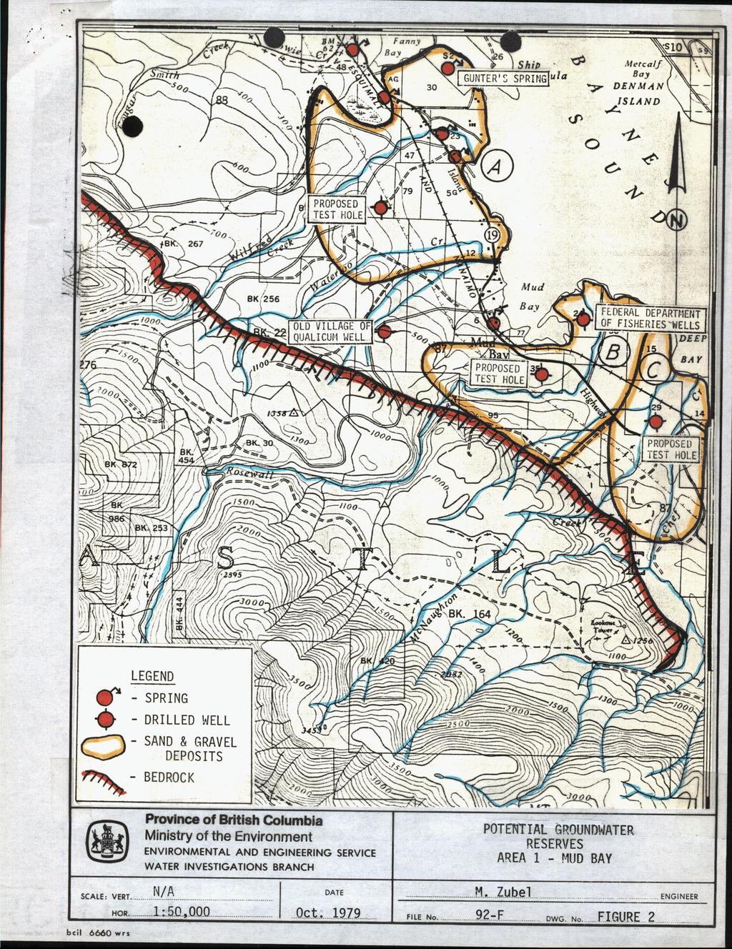
1 Mr. A. P. Kohut Senior Geological Engineer Groundwater Section Date: October 5, 1979 File: NTS 92F Re: Proposed Vancouver Island Fish Hatchery. - Groundwater Supply (Fanny Bay to Nanoose Bay) INTRODUCTION The following report is the result of a prel iminary groundwater study of the area from Fanny Bay to Nanoose Bay (Figure 1). This study includes an office review of available groundwater data such as geologic maps, aerial photographs, well records and previous groundwater reports, as well as the results of a field investigation of selected areas, Cost estimates for test drilling required to prove-up the groundwater supply capability of site specific areas are also discussed. Figure 1 shows the general region of groundwater investigation and the four specific areas in which the groundwater geology, groundwater potential and recommendations for further exploration and development are discussed in detail. These specific areas were chosen on the basis of the surface water supplies which may be available to supplement the potential groundwater source(s) in order to meet water requirement of approximately 30 cfs, needed for fish rearing. AREA 1 <- MUD I BAY A, 'Wilfred Creek - Waterloo Creek ' Surf i ci a1 Geol ogy : The surficial geology of the entire study area has been mapped by Fjles (1963) and serves as a basis of locating potential groundwater reserves in the area. According to Fyles (1963), "the largest groundwater reserves in the area are contained in recent alluvial deposits,':terraced fluvial and deltaic deposits, glacio-fluvial deposits, and in Quadra and other sediments beneath the Vashon drift.'! The sand and gravel within these deposits are- the principal aquifer materials that are permeable enough to transmit substantial amounts of water to wells. Fi ure 2 has been prepared from the surficial geology map by Fyles (19637 and outlines the principal areas of sand and gravel deposits that may contain substantial groundwater reserves. It can be seen that the Waterloo Creek and Wilfred Creek terraced fluvial and deltaic sand and gravel deposits appear extensive and would naturally contain much groundwater. However, the amount of groundwater in storage is primarily based upon the saturated thickness of the deposit. The presence of many springs around the sloping margins of the terraced fluvial deposit suggests that the water level is at less than the 100 ft. elevation, which suggests that the water.pi?vel further inland may be as deep as several hundred feet.... 2
2 - 2 - e-=- The well log data for the Wilfred Creek - Waterloo Creek area is sparse. The available data shows that most wells, located in the deltaic areas are shallow dug household wells with low yields, and the water levels are near ground surface. The only outstanding groundwater anomaly in the area is a spring, locally known as "Gunter's Spring", which has a reported yield of approximately 600 USgpm. Approximately one mile upstream of the mouth of Waterloo Creek, a test hole was drilled 20 years ago for the Village of Qualicum and penetrated 482 feet of surficial materials. According to the driller's log, the test hole encountered an excellent gravel aquifer between 265 and 325 feet below ground level, but was never pump tested to prove its potential. Conclusions and Recommendations: Based upon the extent of permeable sand and gravel in the area of Wilfred Creek and Waterloo Creek and the presence of springs, as well as an indication of a potentially excellent gravel aquifer at depth, the ' possibility of encountering a moderate to high yielding aquifer appears good. It is therefore recommended that a test hole be drilled in the location as shown on Figure 2, and a pump test Ferformed to determine the potent i a 1 y ire 1 d. B. Rosewall Creek Surf i dial Geol ogy : The deltaic and terraced fluvial sand and gravel deposits as outlined in Figure 2 contain the greatest potential groundwater reserve for this watershed. Well Log Data: The Federal Department of Fisheries have two medium capacity wells in the Rosewall Creek delta, not far from the east shore of Plud Bay. The logs of the wells show sand and gravel to approximately 60 feet depth and a static water level less than 15 feet.below ground level. The wells were pump tested up to 610 USgpm. Conclusions and Recommendations: The potential for further groundwater development within the deltaic and terraced fluvial deposits of Rosewall Creek is very good. A teritatsve site for a test well is shown in Figure 2. This site is based upon7accessibility by a drilling rig
3 - 3 - Chef (Cook) Creek - McNaughton Creek b Surf i ci a1 Geology : According to Fyles (1963),-Chef Creek has incised the unconsolidated terrace deposits and exposed tills overlying older sands which in places overlies bedrock. In a recent site investigation, small springs were seen flowing from the base of the older sands along the Chef Creek valley; thereby, indicating that the sub-till deposits seem to contain some groundwater. The amount of groundwater, however, depends upon the thickness of the water-bearing deposits. From a site investigation of a deep gravel pit (just west of Chef Creek and the B.C. Hydro R/W) within the upper terrace deposits, it was observed that the sand and gravel deposit was dry to a depth of about 60 feet. This suggests that the terraced deposits may not be water-bearing for most of its thickness. However, the recent alluvial deposits bordering the sea may contain a substantial reserve of groundwater. The water table in these deposits lies within several feet of the surface. Depending upon the thickness of the water-bearing sands and gravels, these deposits may constitute a significant groundwater reserve in this area. Well Log'Data: There are no records of wells drilled in this area. Conclusions and Recommendations: Based upon the results of wells drilled and tested in the deltaic deposits of Rosewall Creek, the possibility of sirnilau, yields from the deltaic sand and gravel deposits of the Chef - McNaughton Creeks is good. A shallow (Jess than 100 feet deep) test hole is suggested and its location is shown in Figure 2. AREA 2 - QUALICUM RIVERS A. Qual icum River Surficial Geology: According to Fyles (1963), "the valley of Qualicum River is cut into or through the sand unit of the Quadra sediments for much of its length. Seepages and springs emerge from the base of the sand about 150 feet above sea-level in many places along the valley walls. The sands of the Quadra sediments... contain large reserves of groundwater." In Figure 3, the areas which are underlain by sand and gravel deposits are outlined. These areas represent the most obvious sources of groundwater potential. Wel-1 tog Data : The Federal Department of Fisheries have several shallow wells, (less than 100 feet deep) that were drilled in the deltaic deposits along
4 -4- Qualicum River. These wells have reported yields of between 200 and 400 N USgpm, with very little drawdown and a water table near the surface. The recharge to these wells is probably in part from the Qualicum River. Conclusions and Recommendations: The potential for further groundwater development in the deltaic deposits of the Qualicum River appears to be very good. However, test drilling and pumping tests to date have only proven-up medium capacity wells in the area and therefore further drilling and testing may not be any more successful. B. Spider Lake Area Surf i ci a1 Geology : According to Fyles (1963), Spider Lake is situated on a kame-ice contact delta deposit which consists of very permeable sa'nds and gravels. The deposit may locally exceed 50 feet in thickness and therefore, contain substantial amounts of groundwater. The level of the water table is probably about the same level as the lake, which occupies the largest kettle in the area. The source of recharge to this gravel terrace, other than precipitation,.. is not known yet. The level of Spider Lake appears to be somewhat higher than the Qualicum River or Horne Lake, thus suggesting that the natural groundwater gradient is from Splider Lake toward Horne Lake. There is also the possibility that the gravel terrace is very thin and overlies a till deposit thus causing localized high water table conditions. Conclusions and Recommendations: There is no available subsurface data from drilled wells or geophysical surveys in the area of Spider Lake and hence the subsurface conditions are not definitely known. By virtue of the high permeability and large extent of the deposit, as well as the large potential reserve for groundwater, it is suggested that a test hole be drilled in the area to ascertain the subsurface conditions of the gravel deposit and possibly whether any hydraulic continuity exists between Horne Lake and Spider Lake. A tentative drill site is shown in Figure 3. C. Qualicum River fan at Horne Lake Surficial Geology: The Qualicum River fan at the western end of Horne Lake is an extensive deposit of sand, gravel and cobbles which potentially contains a very substantial amount of groundwater. It is expected that large yields can be obtained from shallow wells (less than 100 feet deep) penetrating the fan deposit. The water table is probably at or neat the level of the river.... 5
5 ,,, f yents,and Recommendations: 9E Since there is no subsurface data availab e for this area, it is recommended that a test hole be drilled in the fan to ascertain the nature and depth of the subsurface material an a pump test performed to determine aquifer parameters. is from the Qualicum River and possibly from Horne Lake. of a test hole is shown in Figure 3. AREA 3 - LITTLE QUALICUM RIVER A. River Delta Area Surficial Geology: The source of recharge to the fan The site The surficial geology of the area (Fyles, 1963) indicates that the Little Qualicum River delta area is underlain by coarse-textured alluvium in which the water table lies within a few feet of the surface. The delta is underlain for the most part by thick water-bearing sands and gravels and large yields of water can generally be obtained from shallow wells. Well Log Data: Most of the wells in the Little Qualicum River area are shallow dug wells of low yields. The Village of Qualicum had several shallow wells drilled adjacent to the Little Qualicum River and about a mile upstream from its mouth. Pump test proved-up 360 USgpm with very low drawdowns. Cmments and Recorynendations: A proven groundwater potential exists in the delta. A tentative test drilling site (see Figure 4) tias been located across the river from the Village of Qualicum well, for further proving-up of the groundwater reserve. B. Little Qualicum River - Whisky Creek Confluence Surf icial Geology : The area between the Little Qualicum River and Whisky Creek is underlain by a large terraced fluvial deposit which may contain a substantial amount of groundwater. According to aerial photographs, there appears to be some very large springs issuing from the terraced deposits and probably contributing flow to the Little Qualicum River. Comments and Recommendations : / Without any subsurface data, it is difficult to determine the thickness of the aquifer and thus the actual potential in this area. According to a local driller, a well is presently being drilled in the area for the Federal Department of Fisheries and until the results of
6 -6- umping test are available no action by way of test drilling or further %.i otation is recommended in this area at this time. C. Little Qualicum Falls Park Area Suff icial Geology: According to Fyles (1963), terraced and knob-and-kettle gravel deposits including delta-like forms similar to the Spider Lake terrace, occupy the Little Qualicum Valley northeast of Cameron Lake. The ice-contact deposits consist, typical ly, of we1 1 -sorted and rounded pebble and cobble gravel and pebbly sand. Well Log Data: Only one well is known to have been drilled in the Little Qualicum Falls Park area (Figure 4). Bedrock was encountered at 120 feet and the water level at about 70 feet below the ground. Comments and Recommendations: The available data suggests that there is a great abundance of permeable materials in the area. However, according to the log of the Little Oualicum Falls Park well, the terraced gravel and sand deposit is mostly dry. Further groundwater exploration for high capacity wells in this area is not suggested at this time. AREA 4 - ENGLISHMAN RIVER A. Deltaic Area Surficial Geology: The Englishman River delta (see Figure 5) consists largely of gravel and sand several tens of feet in thickness. This coarse-textured recent alluvium may contain a substantial amount of groundwater if the deposit is thick (greater than 50 feet). Well Logs: Several shallow wells, yielding in excess of 200 USgpm have been constructed in the delta. The water table is within 10 feet of the surface. Comments and Recommendations: Moderate yields of water have been obtained from shallow drilled wells in the delta. Similar to the Rosewall Creek deltaic deposit, larger yields may be obtained from properly developed drilled wells where the alluvium is thicker. However, drilling deeper may encounter salt water, or bedrock, which seems to occur at shallow depths. The probability of finding a thick water-bearing section 06 the alluvium is very low; therefore no further groundwater development is suggested for this area, at this time.... 7
7 - 7 - earea Between Highway and Railway Bridge Surficial Geoloav: This area is underlain by coarse-textured deltaic and fluvial sands and gravels which may contain substantial amounts of groundwater. Well Log Data: The yields from drilled wells in this area is generally low (less than 50 USgpm). One well encountered bedrock at 91 feet and is simply reported to yield "lots" of water.. Comments and Recommendations : Based upon the well log data, it appears that the deltaic and fluvial deposits in this area are not very productive. Further exploration is not suggested at this time for this area. C. Area Between Old Bridge and Confluence of Englishman River and South Englishman River - Surf ici a1 Geology: According to Fyles (1963) this area is underlain by fluvial sands and gravels which may contain substantial amounts.of groundwater. Comments and Recommendations: As there is a lack of subsurface data for this area, it is difficult to predict how thick the surficial sediments are, and hence the potential groundwater -reserve. In a recent field investigation-of the area, it appeared that the water table in the alluvium area was close to the surface, which suggests that the sands and gravels in this area are water-bearing. Further testing is needed to ascertain the subsurface conditions and potential. It is suggested that a seismic survey in conjunction with test drilling be undertaken in the alluvial area. A tentative drill site is shown in Figure 5. COST ESTIMATES FOR TEST DRILLING The following list of estimated costs for a 150 feat well is- based upon the cost.in drilling and testing an observation well near Qualicum Beach earlier this year. According to several dri 11 ing contractors, the cost of drilling is presently increasing due to increased casing costs, and therefore, a 15% contingency has been added to determine the final estimated cost ,
8 ITEM Mobilization, set-up, demobilization 10 ft. surface casing (8-inch diam., drilled) 150 ft, cased drilling (6-inch diam.) Drive shoe (6-inch diam.) 8 ft., 6-inch diam. Screen (installed) We1 1 development (24 hours) Standby & hourly work (8 hours) Pump equip. mob., set-up, demob. Pumping & Recovery test (30 hours) UNIT COST Lump Sum $24/f t. $18/ft. Lump Sum $100/ft. $45/hr. $40/ hr. Lump Sum $35/hr. TOTAL EST. COST $ $ $2, $ $ $1, $ $ $1, = $6, t 15% contingencies = $1, TOTAL ESTIMATED'.COST"= $7, PROPOSED TEST DRILLING SITES In three of the four areas discussed in this report, test drilling in specific areas was recommended. The following list of proposed test drilling sites gives the order of priority (based upon available data) as to the best potential sites for obtaining an adequate groundwater supply to meet an estimated demand of 5 cfs. 1) Qualicum River fan (at Horne Lake) 2) Rosewall Creek delta 3) Wilfred Creek - Waterloo Creek delta 4) Englishman River Floodplain (between the old bridge and confluence of Englishman River and South Englishman River, i.e. area 4C) 5) McNaughton - Chef Creek delta 6) Little Qualicum River delta 7) Spider Lake - Horne Lake area Marc Zubel Geological Engineer Groundwater Section Hydrology Division References Fyles, J.G. (1963). Surficial Geology of Horne Lake and Parksville Map-Areas, Vancouver Is1 and, British Columbia. Geological Survey of Canada. Memoir 318. MZ/ hw

9 1 inch = 4 miles Province of British Columbia SCALE:.... Ministry of the Environment OF AREAS OF bcil 6661 wrs
10

11 I

12

13
Our File: 92 F/1, 92 F/8. Numerous licenced springs occur north of the B.C. Hydro right-of-way on. Water Management Branch
 J.C. Foweraker, Head Groundwater Section Water Management Branch Date: May 23, 1986 Our File: 92 F/1, 92 F/8 Re: Groundwater - D.L. 117. Nanoose District As requested by Mr. B. Hollingshead, Regional Water
,Baynes Lake. TO...?&.?...A 2...KO.?'!!&... Sr. *logical Engineer
 > i evernment OF BRITISH COLUMBIA a TO...?&.?...A 2....KO.?'!!&... Sr. *logical Engineer... Grou,,water. Section Hydrology Division Wat.er... In~.~s.tiga.ti.On.s..Branck.... 5 u BJECT...C;.roun.dw.ater...Snve
June 9, R. D. Cook, P.Eng. Soils Engineer Special Services Western Region PUBLIC WORKS CANADA WESTERN REGION REPORT ON
 PUBLIC WORKS CANADA WESTERN REGION REPORT ON GEOTECHNICAL INVESTIGATION PROPOSED MARTIN RIVER BRIDGE MILE 306.7 MACKENZIE HIGHWAY Submitted by : R. D. Cook, P.Eng. Soils Engineer Special Services Western
Betsy Stevenson and Allison Mohrs (Skagit County Planning and Development Services) Jenny Baker, The Nature Conservancy
 Jenny Baker, The Nature Conservancy") TC Fisher Slough Final Design and Permitting Subject: Well Review Memorandum To: From: Betsy Stevenson and Allison Mohrs (Skagit County Planning and Development Services) Jenny Baker, The ature Conservancy
TC Fisher Slough Final Design and Permitting Subject: Well Review Memorandum To: From: Betsy Stevenson and Allison Mohrs (Skagit County Planning and Development Services) Jenny Baker, The ature Conservancy
MEMORANDUM. wa.tsr..-z.n~.e.s-t.i~at.i.o.ns... Branch... Mr. Webster contends that prior to excavation of the gravel
 TO... J. C. Foweraker 2... Head Gr o w a t er S e c t i on... Hyar....og~~~.~.~vis.ion... wa.tsr..-z.n~.e.s-t.i~at.i.o.ns... Branch... eernment OF BRITISH COLUMBIA MEMORANDUM II 0 PROM A. P. Kohut, Geological
Mark S. Nordberg Geology and Groundwater Investigations Section North Central Region Office California Department of Water Resources
 Mark S. Nordberg Geology and Groundwater Investigations Section North Central Region Office California Department of Water Resources Ukiah Drought Workshop July 29, 2009 Groundwater 101 Groundwater is
Soils, Hydrogeology, and Aquifer Properties. Philip B. Bedient 2006 Rice University
 Soils, Hydrogeology, and Aquifer Properties Philip B. Bedient 2006 Rice University Charbeneau, 2000. Basin Hydrologic Cycle Global Water Supply Distribution 3% of earth s water is fresh - 97% oceans 1%
Ground-Water Exploration in the Worthington Area of Nobles County: Summary of Seismic Data and Recent Test Drilling Results
 Ground-Water Exploration in the Worthington Area of Nobles County: Summary of Seismic Data and Recent Test Drilling Results Jim Berg and Todd Petersen Geophysicists, DNR Waters January 2000 Table of Contents
KANSAS GEOLOGICAL SURVEY Open File Report LAND SUBSIDENCE KIOWA COUNTY, KANSAS. May 2, 2007
 KANSAS GEOLOGICAL SURVEY Open File Report 2007-22 LAND SUBSIDENCE KIOWA COUNTY, KANSAS Prepared by Michael T. Dealy L.G., Manager, Wichita Operations SITE LOCATION The site was approximately four miles
.. :2. Our File: 82 G/3 #2. T 8 A.P. Kohut Senior Geological Engineer Groundwater Sect ion Water Management Branch. Date: August 30, 1985.
 T 8 AP Kohut Senior Geological Engineer Groundwater Sect ion Water Management Branch Date: August 30, 1985 Our File: 82 G/3 #2 Re: Groundwater Levels - Banes Lake Areia At the request of Mr JH Dyck, Regional
reducing flow. in the creek for downstream users having priority surface. At the request of Mr. H.D. DeBeck, Comptroller of Water Rights, an
 .., l@ Dr. J.C. Foweraker, Head Groundwater Sect i on Hydrology Division Water nvestigations Branch Date: September O, 1979 File: 2,9'2 1/10 Fr: A.P. Kohut Sr. Geologi cal Engineer Groundwater Section
SURFACE GEOLOGY AND LIQUEFACTION SUSCEPTIBILITY IN THE INNER RIO GRANDE VALLEY NEAR ALBUQUERQUE, NEW MEXICO
 SURFACE GEOLOGY AND LIQUEFACTION SUSCEPTIBILITY IN THE INNER RIO GRANDE VALLEY NEAR ALBUQUERQUE, NEW MEXICO Keith I. Kelson, Christopher S. Hitchcock, and Carolyn E. Randolph William Lettis & Associates,
Glacial Geology of Moose Point State Park, ME
 Geologic Site of the Month May, 2013 Glacial Geology of Moose Point State Park, Maine 44 o 25 59.18"N, 68 o 56 37.11"W Text and photos by Woodrow B. Thompson, Department of Agriculture, Conservation &
APPENDIX 3B OCCURRENCE OF SIGNIFICANT RIVER ALLUVIUM AQUIFERS IN THE PLATEAU REGION
 Plateau Region Water Plan January 2011 APPENDIX 3B OCCURRENCE OF SIGNIFICANT RIVER ALLUVIUM AQUIFERS IN THE PLATEAU REGION Occurrence of Significant River Alluvium Aquifers in the Plateau Region Prepared
Antelope Hills Directionally Drilled Water Well. Theresa Jehn-Dellaport Jehn Water Consultants, Inc.
 Antelope Hills Directionally Drilled Water Well Theresa Jehn-Dellaport Directional Well Applications Deep Bedrock Aquifers Proven Oil field technology Initial Analysis indicates up to 4 times the production
Groundwater Hydrology
 EXERCISE 12 Groundwater Hydrology INTRODUCTION Groundwater is an important component of the hydrologic cycle. It feeds lakes, rivers, wetlands, and reservoirs; it supplies water for domestic, municipal,
Lower Mainland Surficial Geology From Wisconsin Ice Age to Protocol 21
 Lower Mainland Surficial Geology From Wisconsin Ice Age to Protocol 21 BCEIA BEST Conference 2018 Whistler, BC Kalina Malowany and Virginie Brunetaud Presentation Outline 1. Surficial Geology it s more
Geophysical Exploration in Water Resources Assessment. John Mundell, P.E., L.P.G., P.G. Ryan Brumbaugh, L.P.G. Mundell & Associates, Inc.
 Geophysical Exploration in Water Resources Assessment John Mundell, P.E., L.P.G., P.G. Ryan Brumbaugh, L.P.G. Mundell & Associates, Inc. Presentation Objective Introduce the use of geophysical survey methods
FORENSIC GEOLOGY A CIVIL ACTION
 NAME 89.215 - FORENSIC GEOLOGY A CIVIL ACTION I. Introduction In 1982 a lawsuit was filed on behalf of eight Woburn families by Jan Schlictmann. The suit alleged that serious health effects (childhood
GEOL.3250 Geology for Engineers Glacial Geology
 GEOL.3250 Geology for Engineers Glacial Geology NAME Part I: Continental Glaciation Continental glaciers are large ice sheets that cover substantial portions of the land area. In the region of accumulation
RIVERS, GROUNDWATER, AND GLACIERS
 RIVERS, GROUNDWATER, AND GLACIERS Delta A fan-shaped deposit that forms when a river flows into a quiet or large body of water, such as a lake, an ocean, or an inland sea. Alluvial Fan A sloping triangle
GEOLOGY AND MINERAL RESOURCES OF INDIAN RESERVE 26
 ) 41HI3NW94I4 I R NO 26 1*A1 MANITOULIN ISLAND 010 -f?;. GEOLOGY AND MINERAL RESOURCES OF INDIAN RESERVE 26 September 16, 1975 D. G. Innes, Resident Geologist Sudbury District Ministry of Natural Resources
Finding Large Capacity Groundwater Supplies for Irrigation
 Finding Large Capacity Groundwater Supplies for Irrigation December 14, 2012 Presented by: Michael L. Chapman, Jr., PG Irrigation Well Site Evaluation Background Investigation Identify Hydrogeologic Conditions
Re: Steep Slope Assessment for 2465 Waverly Drive, Blind Bay, BC; Legal Address: Lot 39, Section 18, Township 22, Range 10, Plan 25579, W6M, KDYD.
 OEL File 1563-1 May 30, 2017 Doug Wall PO Box 774 Salmon Arm, BC V1E 4N7 Re: Steep Slope Assessment for 2465 Waverly Drive, Blind Bay, BC; Legal Address: Lot 39, Section 18, Township 22, Range 10, Plan
R.M.HARW & ASSOCIATES LTD. GEOTECHNICAL INVESTIGATION PROPOSED BRIDGE SITE. HELAVA CREEKl MILE MACKENZIE HIGHWAY E-2510 OCTOBER 16, 1973
 El R.M.HARW & ASSOCIATES LTD. GEOTECHNICAL INVESTIGATION PROPOSED BRIDGE SITE HELAVA CREEKl MILE 616.4 MACKENZIE HIGHWAY E-2510 OCTOBER 16, 1973 R,M,HARDV & ASSOCIATES LTD. CONSULTING ENGINEERING & TESTING
 Page 1 of 9 Name: Base your answer to the question on the diagram below. The arrows show the direction in which sediment is being transported along the shoreline. A barrier beach has formed, creating a
The Geology of Sebago Lake State Park
 Maine Geologic Facts and Localities September, 2002 43 55 17.46 N, 70 34 13.07 W Text by Robert Johnston, Department of Agriculture, Conservation & Forestry 1 Map by Robert Johnston Introduction Sebago
Buried-valley Aquifers: Delineation and Characterization from Reflection Seismic and Core Data at Caledon East, Ontario
 Buried-valley Aquifers: Delineation and Characterization from Reflection Seismic and Core Data at Caledon East, Ontario Russell, H.A.J. 1, S.E. Pullan 1, J.A. Hunter 1, D.R. Sharpe 1, and S. Holysh 2 1
Surficial Geologic Mapping Proposal for STATEMAP FY2019
 Surficial Geologic Mapping Proposal for STATEMAP FY2019 presented by David Grimley Illinois State Geological Survey Prairie Research Institute, University of Illinois IGMAC meeting, September 6 th, 2018
Seismic Reflection Imaging across the Johnson Ranch, Valley County, Idaho
 Seismic Reflection Imaging across the Johnson Ranch, Valley County, Idaho Report Prepared for the Skyline Corporation Lee M. Liberty Center for Geophysical Investigation of the Shallow Subsurface (CGISS)
a z41. COMMONWEALTH OF AUSTRALIA DEPARTMENT OF NATIONAL DEVELOPMENT BUREAU OF MINERAL RESOURCES, GEOLOGY AND GEOPHYSICS RECORD 1961 No.
 a z41. COMMONWEALTH OF AUSTRALIA ff..4 *.re /Veis DEPARTMENT OF NATIONAL DEVELOPMENT BUREAU OF MINERAL RESOURCES, GEOLOGY AND GEOPHYSICS RECORD 1961 No. 66 RED TANK BORE GRAVITY SURVEY, PLENTY RIVER, N.T.
11/22/2010. Groundwater in Unconsolidated Deposits. Alluvial (fluvial) deposits. - consist of gravel, sand, silt and clay
 deposits. - consist of gravel, sand, silt and clay") Groundwater in Unconsolidated Deposits Alluvial (fluvial) deposits - consist of gravel, sand, silt and clay - laid down by physical processes in rivers and flood plains - major sources for water supplies
Groundwater in Unconsolidated Deposits Alluvial (fluvial) deposits - consist of gravel, sand, silt and clay - laid down by physical processes in rivers and flood plains - major sources for water supplies
Hydrogeological Assessment for Part of Lots 2 and 3, Concession 5, Township of Thurlow, County of Hastings 1.0 INTRODUCTION. 1.
 February 10,2017 25506400 Ontario Ltd. Foxboro, ON Attention: Brad Newbatt Re: Hydrogeological Assessment for Part of Lots 2 and 3, Concession 5, Township of Thurlow, County of Hastings 1.0 INTRODUCTION
Which map shows the stream drainage pattern that most likely formed on the surface of this volcano? A) B)
 B)") 1. When snow cover on the land melts, the water will most likely become surface runoff if the land surface is A) frozen B) porous C) grass covered D) unconsolidated gravel Base your answers to questions
1. When snow cover on the land melts, the water will most likely become surface runoff if the land surface is A) frozen B) porous C) grass covered D) unconsolidated gravel Base your answers to questions
ASSESSMENT OF THE HYDROGEOLOGY AND GROUND- WATER GEOCHEMISTRY OF SOUTHWESTERN ELMORE COUNTY, ALABAMA
 ASSESSMENT OF THE HYDROGEOLOGY AND GROUND- WATER GEOCHEMISTRY OF SOUTHWESTERN ELMORE COUNTY, ALABAMA Outcrop of Paleozoic metamorphic rock on the Coosa River below Jordan Lake Dam GEOLOGICAL SURVEY OF
Michigan s Geology and Groundwater
 Michigan s Geology and Groundwater Ralph J. Haefner Deputy Director U.S. Geological Survey Michigan-Ohio Water Science Center Lansing, Michigan Outline About the USGS Geology 101 Michigan s geology Bedrock
Wisconsin s Hydrogeology: an overview
 2012 Soil and Water Conservation Society Conference Stevens Point, WI Feb 9, 2012 Wisconsin s Hydrogeology: an overview Ken Bradbury Wisconsin Geological and Natural History Survey University of Wisconsin-Extension
Summary of Hydraulic and Sediment-transport. Analysis of Residual Sediment: Alternatives for the San Clemente Dam Removal/Retrofit Project,
 Appendix N SUMMARY OF HYDRAULIC AND SEDIMENT-TRANSPORT ANALYSIS OF RESIDUAL SEDIMENT: ALTERNATIVES FOR THE SAN CLEMENTE DAM REMOVAL/RETROFIT PROJECT, CALIFORNIA the San Clemente Dam Removal/Retrofit Project,
Land subsidence due to groundwater withdrawal in Hanoi, Vietnam
 Land Subsidence (Proceedings of the Fifth International Symposium on Land Subsidence, The Hague, October 1995). 1AHS Publ. no. 234, 1995. 55 Land subsidence due to groundwater withdrawal in Hanoi, Vietnam
GeothermEx, Inc. GEOTHERMAL RESERVOIR ASSESSMENT METHODOLOGY FOR THE SCIENTIFIC OBSERVATION HOLE PROGRAM, KILAUEA EAST RIFT ZONE, HAWAII TASK 1 REPORT
 (415) 527 9876 CABLE ADDRESS- GEOTHERMEX TELEX 709152 STEAM UD FAX (415) 527-8164 Geotherm Ex, Inc. RICHMOND. CALIFORNIA 94804-5829 GEOTHERMAL RESERVOIR ASSESSMENT METHODOLOGY FOR THE SCIENTIFIC OBSERVATION
Fish Passage at Road Crossings
 Fish Passage at Road Crossings 1 Crossing Design Workshop Outline 1:00 to 2:00 Intro, Design Overview, Channel Width 2:00 to 2:15 Break 2:15 to 3:15 No-Slope, Stream Simulation Design 3:15 to 3:30 Break
The Geology and Hydrogeology of the Spyhill Area
 The Geology and Hydrogeology of the Spyhill Area Clare North (WorleyParsons Komex) and Martin Ortiz (The City of Calgary) 2-Jul-08 Outline Background Site Location Existing Information New Work Geology
Geologic Mapping in Northeastern Illinois. What do we know about. Donald A. Keefer, Director Geologic Mapping and Hydrogeology Center
 Geologic Mapping in Northeastern Illinois & What do we know about Lake County s Geology? Donald A. Keefer, Director Geologic Mapping and Hydrogeology Center Societal Benefits of Mapping Water Supply Delineation,
Conceptual Model of Stream Flow Processes for the Russian River Watershed. Chris Farrar
 Conceptual Model of Stream Flow Processes for the Russian River Watershed Chris Farrar Several features of creeks affect the interactions between surface and groundwater. This conceptual model uses the
THE OHIO JOURNAL OF SCIENCE
 THE OHIO JOURNAL OF SCIENCE VOL. LI JANUARY 1951 No. 1 SHORE EROSION ON SANDUSKY BAY PAUL R. SHAFFER Department of Geology, University of Illinois, Urbana, 111. The south shore of San dusky Bay is undergoing
HYDROGEOLOGICAL PROPERTIES OF THE UG2 PYROXENITE AQUIFERS OF THE BUSHVELD COMPLEX
 R. Gebrekristos, P.Cheshire HYDROGEOLOGICAL PROPERTIES OF THE UG2 PYROXENITE AQUIFERS OF THE BUSHVELD COMPLEX R. Gebrekristos Digby Wells Environmental P. Cheshire Groundwater Monitoring Services Abstract
GPR AS A COST EFFECTIVE BEDROCK MAPPING TOOL FOR LARGE AREAS. Abstract
 GPR AS A COST EFFECTIVE BEDROCK MAPPING TOOL FOR LARGE AREAS Dr. Jutta L. Hager, Hager GeoScience, Inc., Waltham, MA Mario Carnevale, Hager GeoScience, Inc., Waltham, MA Abstract Hager GeoScience, Inc.
Appendix D. Sediment Texture and Other Soil Data
 5 6 7 8 Appendix D. Sediment Texture and Other Soil Data This appendix describes the sediment texture of the aquifer system in the Restoration Area. The contents of this appendix describe the: Importance
Sediment and sedimentary rocks Sediment
 Sediment and sedimentary rocks Sediment From sediments to sedimentary rocks (transportation, deposition, preservation and lithification) Types of sedimentary rocks (clastic, chemical and organic) Sedimentary
Appendix G. Summary of Hydrogeologic Conditions and Historical Mining Northwest of the Centro Subarea in the Randsburg, Red Mountain, and Atolia Area
 Appendix G Summary of Hydrogeologic Conditions and Historical Mining Northwest of the Centro Subarea in the Randsburg, Red Mountain, and Atolia Area 1.1 Background This appendix provides a summary of hydrogeologic
ARSENIC. 12 Arsenic contamination of groundwater in Bangladesh
 12 Arsenic contamination of groundwater in Bangladesh ARSENIC The point-source maps for arsenic show the distributions based on both rounded quartiles and on health criteria, including the WHO guideline
Geophysical Surveys for Groundwater Modelling of Coastal Golf Courses
 1 Geophysical Surveys for Groundwater Modelling of Coastal Golf Courses C. RICHARD BATES and RUTH ROBINSON Sedimentary Systems Research Group, University of St. Andrews, St. Andrews, Scotland Abstract
How to Identify and Properly Classify Drill Cuttings
 How to Identify and Properly Classify Drill Cuttings (Creating Useful Borehole Logs) Dave Larson Hydrogeology and Geophysics Section Accurate information about the borehole location and a careful description
Subsurface Geology of the Kennebec River
 Maine Geologic Facts and Localities July, 1998 Subsurface Geology of the Kennebec River 43 54 40.75 N, 69 48 29.01 W Text by Daniel B. Locke, Department of Agriculture, Conservation & Forestry 1 Map by
4. The map below shows a meandering stream. Points A, B, C, and D represent locations along the stream bottom.
 1. Sediment is deposited as a river enters a lake because the A) velocity of the river decreases B) force of gravity decreases C) volume of water increases D) slope of the river increases 2. Which diagram
Geology and Soils. Technical Memorandum
 Geology and Soils Technical Memorandum TO: FDOT FROM: HDR, Inc. DATE: February 2013 PROJECT: St Johns River Crossing FPID No: 208225-3-21-01 Clay, Duval, and St. Johns Counties; Florida Geology and soils
Illinois State Water Survey Division
 Illinois State Water Survey Division SURFACE WATER SECTION SWS Contract Report 413 AT THE UNIVERSITY OF ILLINOIS SEDIMENTATION SURVEY OF DAWSON LAKE, MORAINE VIEW STATE PARK, MC LEAN COUNTY, ILLINOIS by
Groundwater Level Monitoring of the Quaternary Aquifer at Al Ain City, United Arab Emirates (UAE) using Geophysical Methods
 using Geophysical Methods") Groundwater Level Monitoring of the Quaternary Aquifer at Al Ain City, United Arab Emirates (UAE) using Geophysical Methods Ahmed Murad & Amir Gabr Geology Department UAE University Outlines Introduction
Groundwater Level Monitoring of the Quaternary Aquifer at Al Ain City, United Arab Emirates (UAE) using Geophysical Methods Ahmed Murad & Amir Gabr Geology Department UAE University Outlines Introduction
Pre-Lab Reading Questions ES202
 ES202 The are designed to encourage students to read lab material prior to attending class during any given week. Reading the weekly lab prior to attending class will result in better grade performance
was givenm line cutting, in order to provide access through-the thick bush, June Hydrology Division
 Hydrology Division Jordan River Correctional Camp Water Supply Investigation J. C.. Foweraker Head Groundwater Section June 23 75 0239013 General Following a request from the Department of Public Works,
14 Geotechnical Hazards
 Volume 2: Assessment of Environmental Effects 296 14 Geotechnical Hazards Overview This Chapter provides an assessment of the underlying geotechnical conditions to identify: any potential liquefaction
How & Where does infiltration work? Summary of Geologic History Constraints/benefits for different geologic units
 June 26, 2007: Low Impact Development 1 Associated Earth Sciences, Inc. Associated Earth Sciences, Inc. Presented by: Matthew A. Miller, PE April 24, 2012 How & Where does infiltration work? Summary of
CJ AREA MAPPED IN 1978 FOR QUATERNARY GEOLOGY ~ AREA MAPPED IN FOR QUATERNARY GEOLOGY. I I I j I I I -44-
 -44- ~. ~/
Geological Models for Infrastructure Design:
 Geological Models for Infrastructure Design: Reducing Geotechnical Risk and Supporting Sustainability Alan Keith Turner Emeritus Professor of Geological Engineering CSM Visiting Research Associate - British
16 January 2018 Job Number: RICHARD NEWMAN C\- CLARK FORTUNE MCDONALD AND ASSOCIATES PO BOX 553 QUEENSTOWN
 16 January 2018 Job Number: 50595 RICHARD NEWMAN C\- CLARK FORTUNE MCDONALD AND ASSOCIATES PO BOX 553 QUEENSTOWN CHANSEN@CFMA.CO.NZ STORMWATER DISPOSAL ASSESSMENT Dear Richard, RDAgritech were requested
TEMPERATURE GEOTHERMAL SYSTEM *.BY. Roger F. Harrison Salt Lake City, Utah. C; K. Blair
 - * f c * -6 9 -.I. lcal '. DEVELOPMENT AND TESTSNG OF A SMALL MODERATE TEMPERATURE GEOTHERMAL SYSTEM *.BY Roger F. Harrison Terra Tek, Inc. Salt Lake City, Utah C; K. Blair Terra Tek, Inc. - Salt Lake
REVISED PRELIMINARY ASSESSMENT OF GROUNDWATER AVAILABILITY DISTRICT OF PEACHLAND, BRITISH COLUMBIA
 Golder Associates Ltd. #220-1755 Springfield Road Kelowna, British Columbia, Canada V1Y 5V5 Telephone (250) 860-8424 Fax (250) 860-9874 November 24, 2006 05-1440-024 Corporation of the District of Peachland
Delineation of Zones at Risk from Groundwater Inflows at an Underground Platinum Mine in South Africa
 Delineation of Zones at Risk from Groundwater Inflows at an Underground Platinum Mine in South Africa Mr Andreas Stoll andreas.stoll@erm.com Environmental Resources Management Swiss GmbH (ERM), Switzerland
THE OHIO JOURNAL OF SCIENCE
 THE OHIO JOURNAL OF SCIENCE VOL. LIII MARCH, 1953 No. 2 SUBSURFACE STUDY OF GLACIAL DEPOSITS AT CLEVELAND, OHIO C. T. BAGLEY Sverdrup & Parcel, Inc., Consulting Engineers, St. Lotus, Mo. The soil 1 strata
Lecture Outlines PowerPoint. Chapter 5 Earth Science 11e Tarbuck/Lutgens
 Lecture Outlines PowerPoint Chapter 5 Earth Science 11e Tarbuck/Lutgens 2006 Pearson Prentice Hall This work is protected by United States copyright laws and is provided solely for the use of instructors
A Preliminary Geophysical Reconnaissance Mapping of Emirau Ground Water Resource, Emirau Island, New Ireland Province, PNG
 A Preliminary Geophysical Reconnaissance Mapping of Emirau Ground Water Resource, Emirau Island, New Ireland Province, PNG Geological Survey Division of Mineral Resources Authority (MRA) Papua New Guinea
3.18 GEOLOGY AND SOILS
 3.18 GEOLOGY AND SOILS This section discusses geologic resource concerns as they relate to the environment, public safety, and project design both during construction and after completion of the project.
Lecture Outline Wednesday - Friday February 14-16, 2018
 Lecture Outline Wednesday - Friday February 14-16, 2018 Quiz 2 scheduled for Friday Feb 23 (Interlude B, Chapters 6,7) Questions? Chapter 6 Pages of the Past: Sedimentary Rocks Key Points for today Be
CHAPTER 28. PHYSIOGRAPHY Cook Inlet Drainages
 PEBBLE PROJECT ENVIRONMENTAL BASELINE DOCUMENT 2004 through 2008 CHAPTER 28. PHYSIOGRAPHY Cook Inlet Drainages PREPARED BY: Knight Piésold Ltd. PHYSIOGRAPHY COOK INLET DRAINAGES TABLE OF CONTENTS TABLE
PHASE 1 STUDIES UPDATE EROSION WORKING GROUP
 PHASE 1 STUDIES UPDATE EROSION WORKING GROUP Presented By MICHAEL WOLFF, PG Erosion Study Area Manager West Valley Demonstration Project Quarterly Public Meeting February 24, 2016 OUTLINE Study 1 Terrain
Jurassic earthquake sequence recorded by multiple generations of sand blows, Zion National Park, Utah
 GSA DATA REPOSITORY 2013313 D.B. Loope et al. Supplemental Information Jurassic earthquake sequence recorded by multiple generations of sand blows, Zion National Park, Utah Item DR1 The following text
CHAPTER 6, PRELIMINARY SITE INVESTIGATION CONTENTS
 CHAPTER 6, PRELIMINARY SITE INVESTIGATION CONTENTS - Page Purpose... 6-1 Assembly of data... 6-1 Use of aerial photographs... 6-2 Field study... 6-3 Mappix... 6-4 Repcrt of preliminary investigation...
Proposed Cemetery Thornhill Road. Tier One Hydrogeological Risk Assessment. Peter Mitchell Associates
 Proposed Cemetery Thornhill Road Tier One Hydrogeological Risk Assessment Peter Mitchell Associates January 2015 Executive Summary This report uses a desk-based risk assessment technique published by the
Hydrogeology of the San Agustin Plains
 Hydrogeology of the San Agustin Plains Alex Rinehart, Daniel Koning and Stacy Timmons New Mexico Bureau of Geology New Mexico Tech 16 August 2017 62nd New Mexico Water Conference Acknowledgments Community
August 21, 2015 Project No. EH130228A. Concrete Nor West P.O. Box 280 Mount Vernon, Washington Attention: Mr. Dan Cox
 August 21, 2015 Project No. EH130228A Concrete Nor West P.O. Box 280 Mount Vernon, Washington 98273 Attention: Mr. Dan Cox Subject: Hydrogeologic Site Assessment Concrete Nor West Grip Road Mine Skagit
Waterbury Dam Disturbance Mike Fitzgerald Devin Rowland
 Waterbury Dam Disturbance Mike Fitzgerald Devin Rowland Abstract The Waterbury Dam was completed in October 1938 as a method of flood control in the Winooski Valley. The construction began in April1935
Aquifer an underground zone or layer of sand, gravel, or porous rock that is saturated with water.
 Aggradation raising of the streambed by deposition that occurs when the energy of the water flowing through a stream reach is insufficient to transport sediment conveyed from upstream. Alluvium a general
Groundwater Investigation SOUTHGATE GRAVEL PIT Part of Lot 15, Concession 15 (formerly Township of Proton), Township of Southgate.
, Township of Southgate.") Groundwater Investigation SOUTHGATE GRAVEL PIT Part of Lot 15, Concession 15 (formerly Township of Proton), Township of Southgate County of Grey October, 2014 Prepared for: Drysdale Aggregate Consulting
Groundwater Investigation SOUTHGATE GRAVEL PIT Part of Lot 15, Concession 15 (formerly Township of Proton), Township of Southgate County of Grey October, 2014 Prepared for: Drysdale Aggregate Consulting
PolyMet NorthMet Project
 RS 26 Draft-01 December 8, 2005 RS26 Partridge River Level 1 Rosgen Geomorphic Survey Rosgen Classification Partridge River from Headwaters to Colby Lake Prepared for PolyMet NorthMet Project December
Geology and New England Landscapes
 Geology and New England Landscapes Jim Turenne, CPSS USDA-NRCS Warwick, RI. http://nesoil.com Why Geology? Provides the big picture of site conditions. Major part of soil formation (parent material and
AWRA PMAS Engineers Club of Philadelphia. A Geologic Perspective on Stormwater
 AWRA PMAS Engineers Club of Philadelphia A Geologic Perspective on Stormwater Toby J. Kessler, P.G. Hydrogeologist Trevor G. Woodward, P.G. Engineering Geologist September 10, 2014 Gilmore & Associates,
Lab 7: Sedimentary Structures
 Name: Lab 7: Sedimentary Structures Sedimentary rocks account for a negligibly small fraction of Earth s mass, yet they are commonly encountered because the processes that form them are ubiquitous in the
Maggie Payne Jim Turenne
 Maggie Payne Jim Turenne USDA-NRCS 60 Quaker Lane, Suite 46 Warwick, RI. 02886 401-822-8832 maggie.payne@ri.usda.gov U.S. Department of Agriculture 1935: Soil Conservation Service (SCS) Natural Resources
INTRODUCTION. LOCATION OF THE STUDY AREA. DRILLING HISTORY OF THE AREA. GEOLOGY AND HYDROGEOLOGY OF THE AREA. HYDROLOGY OF THE AREA.
 INTRODUCTION. LOCATION OF THE STUDY AREA. DRILLING HISTORY OF THE AREA. GEOLOGY AND HYDROGEOLOGY OF THE AREA. HYDROLOGY OF THE AREA. RESULT ANALYSIS AND INTERPRETATION. DISCUSSION. RECOMMENDATION AND CONCLUSION.
HYDROGEOLOGIC FRAMEWORK OF LONG ISLAND'S NORTH FORK, SUFFOLK COUNTY, NEW YORK
 HYDROGEOLOGIC FRAMEWORK OF LONG ISLAND'S NORTH FORK, SUFFOLK COUNTY, NEW YORK Christopher E. Schubert 1, Richard E. Bova 2, and Paul E. Misut 1 1 U.S. Geological Survey, 2045 Route 112, Building 4, Coram,
' International Institute for Land Reclamation and Improvement. 2 Groundwater Investigations. N.A. de Ridder'? 2.1 Introduction. 2.
 2 Groundwater Investigations N.A. de Ridder'? 2.1 Introduction Successful drainage depends largely on a proper diagnosis of the causes of the excess water. For this diagnosis, one must consider: climate,
Groundwater Resources of Missouri. Cynthia Brookshire, R. G.
 Groundwater Resources of Missouri Cynthia Brookshire, R. G. GROUNDWATER... Water beneath the Earth s surface within a zone of saturation AQUIFER... A geologic formation or group of formations that are
Why is Sebago Lake so deep?
 Maine Geologic Facts and Localities February, 1999 Why is Sebago Lake so deep? 43 51 13.36 N, 70 33 43.98 W Text by Robert A. Johnston, Department of Agriculture, Conservation & Forestry 1 Introduction
FRACTURE TRACES AND PRODUCTIVITY OF MUNICIPAL WELLS IN THE MADISON LIMESTONE, RAPID CITY, SOUTH DAKOTA
 Proceedings of the South Dakota Academy of Science, Vol. 87 (2008) 261 FRACTURE TRACES AND PRODUCTIVITY OF MUNICIPAL WELLS IN THE MADISON LIMESTONE, RAPID CITY, SOUTH DAKOTA Perry H. Rahn Department of
Chapter 13. Groundwater
 Chapter 13 Groundwater Introduction Groundwater is all subsurface water that completely fills the pores and other open spaces in rocks, sediments, and soil. Groundwater is responsible for forming beautiful
Napa County Comprehensive Groundwater Monitoring Program 2015 Annual Report and CASGEM Update
 Napa County Comprehensive Groundwater Monitoring Program 2015 Annual Report and CASGEM Update April 21, 2016 Watershed Information & Conservation Council By Vicki Kretsinger Grabert Overview Evolving groundwater
6. GEOTECHNICAL STUDIES, SEISMICITY AND VOLCANISM
 Geotechnical Studies, Seismicity, and Volcanism Bristol Bay Drainages 6. GEOTECHNICAL STUDIES, SEISMICITY AND VOLCANISM 6.1 Introduction This chapter describes the baseline geotechnical characteristics
=%REPORT RECONNAISSANCE OF CHISHOLM LAKE PROSPECT. October 25, 1977
 =%REPORT ON FIELD RECONNAISSANCE OF CHISHOLM LAKE PROSPECT October 25, 1977 Bruce D. Vincent Imperial Oil Limited, Minerals - Coal, CALGARY, ALBERTA CHISHOLM LAKE PROSPECT Introduction The Chisholm Lake
Four Mile Run Levee Corridor Stream Restoration
 Four Mile Run Levee Corridor Stream Restoration 30% Design Summary U.S. Army Corps of Engineers, Baltimore District Presentation Outline Four Mile Run 1.) Historic Perspective 2.) Existing Conditions 3.)
What are the different ways rocks can be weathered?
 Romano - 223 What are the different ways rocks can be weathered? Weathering - the breakdown of rocks and minerals at the Earth s surface 1. 2. PHYSICAL WEATHERING Rock is broken into smaller pieces with