GEO-INFORMATION STRATEGY FOR RURAL DEVELOPMENT: A case study of Aurangabad District, Bihar.
|
|
|
- Edgar Haynes
- 5 years ago
- Views:
Transcription
1 GEO-INFORMATION STRATEGY FOR RURAL DEVELOPMENT: A case study of Aurangabad District, Bihar.
2 INTRODUCTION Geo-information provides a scientific base as an active database for the planning in general and rural development in particular as there is lack of rural resource database in general and the study area in particular. In the present paper an attempt has been made to synchronize the future development & planning with geo-information and central places existing in the District of Aurangabad (Bihar) for decision making and planning for rural development through service centres
3 INTRODUCTION Micro-level planning and integrated development strategies have attracted attention of the authorities and planners, as this is also a technological solution to develop any region at the grass root level and provide benefit to the poorest of the poor. All planners across the world has realized that there is no planning without giving due importance to central places in hierarchical perspective. The pioneering work that needs our attention is Growth Pole Model.
4 INTRODUCTION A micro-level study of Aurangabad district(bihar) India, has been taken as the study area. The author has taken up the analysis work, both at district and at the block level so that the spatial pattern of the central places, it s natural and socioeconomic phenomenon can emerge in a more effective and sustainable manner.

5 The study Area
6 INTRODUCTION In the present study author has identified central places of the different orders, on the basis of 39 variables of socio-economic importance, as the vehicle of development. Some more rural service centres have been proposed with the help of Remote sensing and GIS based on geo-information related with the study area. Based on physical-socio-economic resources an attempt has been made to highlight the basic strategy for Area based planning. Alternative plans have been provided in certain proposed service centres to develop the study area as a whole, with the help of geo-information.
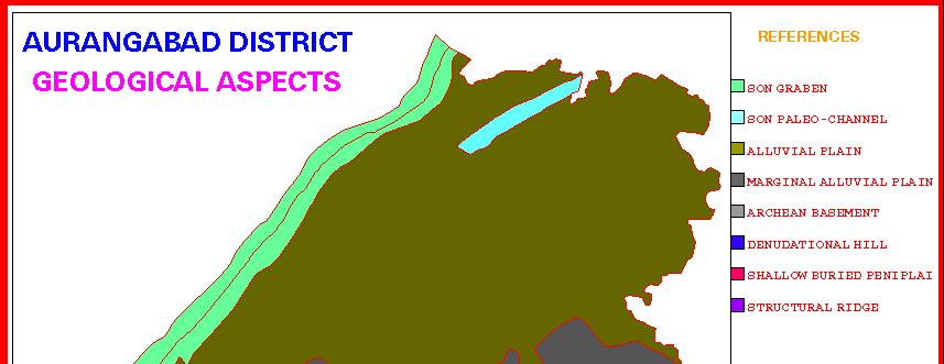
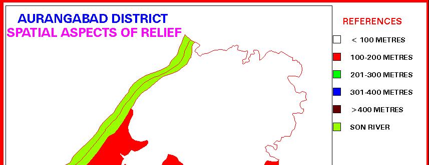
7 METHODOLOGY Physical Geo-information like geology, relief, groundwater potentiality, drainage, soil, land use /cover etc.layers have been prepared with the help of remote sensing technique in which digital analysis have been done using LISS- III, PATH & ROW scene of two seasons digital data with the help of GEOMATICA software of image processing.
8


9
10

11
12 METHODOLOGY Information of social provisions like, hospital, primary health centres, dispensary, maternity child welfare centres, post offices, post and telegraph offices, high schools, colleges, training & technical institute their location have been digitized as information received by district centres. SOI- toposheets and District Census handbook have also been used to incorporate information in different layers.
13
14 METHODOLOGY Economic provisions like canal networks, transport networks, etc. have also been digitized and were placed in GIS environment

15

16


17
18 Identification of central places.- Those settlements which are predominately concerned with serving the needs of their surrounding areas are called Central Places. Central places play a very crucial role in the regional Central places play a very crucial role in the regional development. Their role in the regional development is not only because central places function as economic service centres to it s surrounding region, they also spread ideas of modern technology and modern values towards their hinterland, which also helps in better development and prosperity.
19 Importance of Central places in Decentralized Planning processes of India The planning processes for decentralized planning has also identified the role of central places. After IV five years plan it was felt that sectoral priorities and planning from top level is little helpful in providing better result as far as socio-economic development to the people is concerned. Since then the sectoral approach has been changed into integrated area development in which central places either urban or rural service centres are being considered as focal point for the decentralized planning. This is really a basic approach towards assessing the regional or local resources and evaluating their role in the regional development.
20 Sr.No Table no-1 Population size > No of settlements
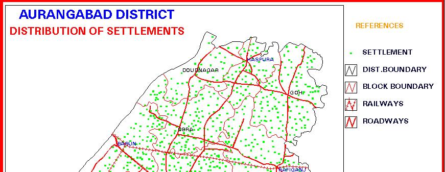
21 All 287 settlement were digitized and were kept in GIS environment. Based on their central functions later on 71 settlements selected through GIS query system based on the reasoning that those centres which are performing more than 7 service ranging from VII group of services. Services considered have been listed
22
23 List of Service group and central services Service Groups Services (1(1) Administrative Provisions 1. District headquarter 2. Sub division office 3. Police stations 4. C.D. Block 5. Gram Panchayat office 6. Municipal office (ii) Educational provision:- 7. primary School 8. Middle School 9. High School 10. Intermediate School 11.Degree College 12.Traning&Technical Institute
24 (iii) Medical Provision :- 13. Hospital 14. Health centre 15. State dispensary 16. Nursing home 17. Veterinary centres 18. Veterinary sub centres ((iv) Communication :- 19. Post office 20. Post & telegraph office 21. Telephone services 22. Bus Stand 23. Railway stations (v) Commercial provisions 24. Permanent market 25. periodical hats 26. Commercial Bank 27. Electrification 28. Large Industrial Unit 29. Small Industrial Unit 30. Tiny Industrial Unit
25 (vi)agricultural Provisions :- 31. Biscouman Depot. 32. Co-oprative Bank 33. Land development Bank 34. Fertilizer Depot 35. H.Y.V. seed depot 36. Vaypar mandal 37. Agricultural implements (vii) Other Services :- 38. Tap water 39. Urban centres (NAC)

26


27


28
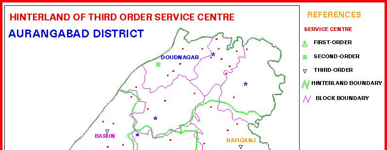
29 Order of hierarch y Name of hierarchy 1st order Growth centre >7 2nd order 3rd order Growth point,5-7 Service centre,3-5 Table no-4. Hierarchy Level Centrality index value Number of centre places Name of central places 1 Aurangabad 1 Daudnagar 3 Barun, Nabinagar,Rafiga nj 4th order Rural service centre,3-1 8 Madanpur, Goh, Haspura, Obra, Jamhaur, Kutumba, Amba
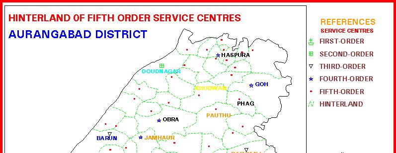
30 5th order Village service centre < 1 58 Ketaki, Pauthu, Pawai, Khemda, Siris, Risiap, Tanrwa, Kataia,Dihra,Tarar, Ankora, Kara,Baghoi, Kiriawan, Kajpa, Khudwan, Deohara, Baligaon, Phag,Charankala, Bhadwa, Poiwan, Riur, Salayia, Ghatrain, Mahuwan, Matpa, Phesar, Samser nagar, Mali, Naugarh, Malhara, Pipra, Bghoi, Sansa, Bharuli, Piru,Sihuli, Gobardhanpur, Kamnpi, Baluganjbrandi, Khanda, Arathua, Amjhar, Warkhas, Dhanwan, Karma, Barem, Sori, Umga, Nimaajan, Dumra, Teldiha, Baruli, Itwan, Hathiyara, Beshani, Amauna, Ramngar and Pogar.

31

32
33

34
35
36 Table no-5 Sr.no Name of Growth Centres. Percentage of working population in Secondary & tertiary activities. Existing Important industrial works 1. Doudnagar Brass & pottery works,carpet weaving,blanket weaving,lac works,brick klin,stone crushing,cloth weaving, handloom, oil and flour mills,rice mills. 2. Barun Vanaspati ghee,glass,smokeless fuel,stone crushing,rice clin,oil & flour mills e.t.c. 3. Nabinagar Cloth weaving,handloom works,biri making,stone crushing,rice mills,pottery making,basket making,lac works. 4. Rafiganj Cloth weaving,handloom,biri,stone crushing,pottery making,basket making,lac works. 5. Madanpur Rice & flour mills,brick clean,cloth weaving,blanket weaving,stone crushing,lac works e.t.c. Proposed industrial works. Glass industry,sugar industry,food processing industry,dairy industry,woolen clothes industry e.t.c. Iron and steel works,food processing,hush based paper industry,sugar industry e.t.c. Agro-based industries like sugar.food processing,dairy e.t.c. Forest based industries like paper, brick klin,glass industry e.t.c. Food processing,stone chips,dairy industry,cloth industry,readymade garments industry e.t.c. Food processing,paper industry,lac industry,ready made garments,mat weaving e.t.c.
37 6. Goh Rice,flour and oil mills,stone crushing,biri making,handloom & pottery works. 7. Haspura Cloth weaving,handloom,pottery works,brick clin,rice & flour mills e.t.c. 8. Obra Carpet weaving,dyeing,cloth making,blanket weaving,carpet weaving,handloom and powerloom industries e.t.c. Food processing,packagin g,sugar,glass industries e.t.c. Readymade garments,dairy,food processing,hushbased paper and power industries Carpet weaving,readymade garments,blanket weaving,dairy & food processing,dyeing industries,sugar industry e.t.c.
38 9. Deo Blanket weaving,handloom & power loom,brass works,earthen tile,pottery making,rice & flour mills. 10. Jamhaur Rice and flour mills, handloom & powerlooms,blanket industry,brick klin,pottery &earthenware. Food processing &dairy industries,cement,carpet weaving,textile,readymade garments,fertilizer,tourism industries e.t.c. Cement,dairy,carpet weaving,readymade garments,textile,fertilizer,cardboardindustries e.t.c. 11 Kutumba Stone Rice & flour mills,paper & hardboard crushing,cloth,handloom blanket weaving,rice & flour mills. 12. Amba Carpet & blanket weaving,rice,flour,lac works,wooden works,earthen pottery & tile industries e.t.c. 13. Pauthu Rice & flour mills,sugar,rope weaving,earthen tile & pottery making e.t.c. industries,packing,cork,glass,cement,plywood & building industries,e.t.c. Furniture,sugar,food processing.dairy.glass,hardboard,paper,plywood,lac works,glass industries e.t.c. Hush based paper.power,dairy,iron & steel works.food processing,ready made garments industries e.t.c.
39 The above study shows that Geoinformatic can play a decisive role in the rural development as it provide better visual shares and query system to reach on certain decision making for the decentralized planning.
40 THE END
APPRAISAL OF INFRASTRUCTURE FACILITIES OF A BACKWARD TALUKA ON GIS PLATFORM CASE STUDY OF NIZAR TALUKA OF TAPI DISTRICT, GUJARAT, INDIA
 APPRAISAL OF INFRASTRUCTURE FACILITIES OF A BACKWARD TALUKA ON GIS PLATFORM CASE STUDY OF NIZAR TALUKA OF TAPI DISTRICT, GUJARAT, INDIA Himanshu Chandra 1, B.K. Patel 2 1 Sr.Urban Planner & GIS Analyst,
NETWORK ANALYSIS FOR URBAN EMERGENCY SERVICES IN SOLAPUR CITY, INDIA: A GEOINFORMATIC APPROACH
 NETWORK ANALYSIS FOR URBAN EMERGENCY SERVICES IN SOLAPUR CITY, INDIA: A GEOINFORMATIC APPROACH Sagar P. Mali * & Yogesh A. Mane ** * Research Student, Department of Geography, Shivaji University, Kolhapur,
GEOSTATISTICAL MODELLING FOR ASSESSMENT OF DEVELOPMENT AT MICRO LEVEL INTRODUCTION
 GEOSTATISTICAL MODELLING FOR ASSESSMENT OF DEVELOPMENT AT MICRO LEVEL Dr. R.D. Gupta Assistant Professor Department of Civil Engineering Motilal Nehru National Institute of Technology Allahabad- 211004,
Integrated Geodatabase Model for effective planning of District -Hamirpur
 Integrated Geodatabase Model for effective planning of District -Hamirpur Developed by District Administration,Hamirpur in collaboration with Centre for Geoinformatics Research and Training, CSK HPAU,Palampur
THE ROLE OF GEOSPATIAL TECHNOLOGY IN SOCIAL AMENITIES FOR RURAL DEVELOPMENT
 THE ROLE OF GEOSPATIAL TECHNOLOGY IN SOCIAL AMENITIES FOR RURAL DEVELOPMENT ANAND P. PANDIT, P.G. Department of Geography, New Arts Commerce and Science College, Ahmednagar. (MS) INDIA MADHUKAR R. KARALE
The National Spatial Strategy
 Purpose of this Consultation Paper This paper seeks the views of a wide range of bodies, interests and members of the public on the issues which the National Spatial Strategy should address. These views
SPATIO-TEMPORAL ANALYSIS OF URBAN POPULATION GROWTH AND DISTRIBUTION IN AURANGABAD CITY
 International Journal of Research in Social Sciences Vol. 8 Issue 3, March 2018, ISSN: 2249-2496 Impact Factor: 7.081 Journal Homepage: Double-Blind Peer Reviewed Refereed Open Access International Journal
A Remote Sensing and GIS approach to trace the Densification in Residential Areas
 A Remote Sensing and GIS approach to trace the Densification in Residential Areas Valliappan AL Assistant Professor, School of Planning and Architecture, Vijayawada, India. Date:11/03/2015 What is Densification?
Introduction to GIS. Dr. M.S. Ganesh Prasad
 Introduction to GIS Dr. M.S. Ganesh Prasad Department of Civil Engineering The National Institute of Engineering, MYSORE ganeshprasad.nie@gmail.com 9449153758 Geographic Information System (GIS) Information
Georeferencing and Satellite Image Support: Lessons learned, Challenges and Opportunities
 Georeferencing and Satellite Image Support: Lessons learned, Challenges and Opportunities Shirish Ravan shirish.ravan@unoosa.org UN-SPIDER United Nations Office for Outer Space Affairs (UNOOSA) UN-SPIDER
TOWARDS STRATEGIC SPATIAL PLANNING IN JAMAICA: THE NATIONAL SPATIAL PLAN
 TOWARDS STRATEGIC SPATIAL PLANNING IN JAMAICA: THE NATIONAL SPATIAL PLAN JIEP 5th Biennial Conference on the Environment: Balancing National Development and Environmental Protection June 6, 2011 Jamaica
CENSUS MAPPING WITH GIS IN NAMIBIA. BY Mrs. Ottilie Mwazi Central Bureau of Statistics Tel: October 2007
 CENSUS MAPPING WITH GIS IN NAMIBIA BY Mrs. Ottilie Mwazi Central Bureau of Statistics E-mail: omwazi@npc.gov.na Tel: + 264 61 283 4060 October 2007 Content of Presentation HISTORICAL BACKGROUND OF CENSUS
Chapter 10 Human Settlement Geography Book 1 Class 12
 CHAPTER 10 HUMAN SETTLEMENTS 1. RURAL, SUB URBAN AND URBAN SETTLEMENTS: This classification is common worldwide but the criteria differ from country to country. 5. Criteria for classification differs from
Urban Hydrology - A Case Study On Water Supply And Sewage Network For Madurai Region, Using Remote Sensing & GIS Techniques
 RESEARCH INVENTY: International Journal of Engineering and Science ISBN: 2319-6483, ISSN: 2278-4721, Vol. 1, Issue 8 (November 2012), PP 07-12 www.researchinventy.com Urban Hydrology - A Case Study On
Minimum Wage in Gujarat w.e.f 1st Apr 2018 to 30th Sep-2018
 Scheduled Employment Category of Workers Zone Basic Salary Automobile repairing Workshop and Garrages Bakeries Bobin Industry Brick Manufacturing Industry (1000 Bricks) Cement Prestressed Products Industry
Use of Geospatial data for disaster managements
 Use of Geospatial data for disaster managements Source: http://alertsystemsgroup.com Instructor : Professor Dr. Yuji Murayama Teaching Assistant : Manjula Ranagalage What is GIS? A powerful set of tools
Joanne N. Halls, PhD Dept. of Geography & Geology David Kirk Information Technology Services
 Joanne N. Halls, PhD Dept. of Geography & Geology David Kirk Information Technology Services Geographic Information Systems manage and analyze data to solve spatial problems. Real World Abstraction Analysis
Calculating Land Values by Using Advanced Statistical Approaches in Pendik
 Presented at the FIG Congress 2018, May 6-11, 2018 in Istanbul, Turkey Calculating Land Values by Using Advanced Statistical Approaches in Pendik Prof. Dr. Arif Cagdas AYDINOGLU Ress. Asst. Rabia BOVKIR
VILLAGE INFORMATION SYSTEM (V.I.S) FOR WATERSHED MANAGEMENT IN THE NORTH AHMADNAGAR DISTRICT, MAHARASHTRA
 FOR WATERSHED MANAGEMENT IN THE NORTH AHMADNAGAR DISTRICT, MAHARASHTRA") VILLAGE INFORMATION SYSTEM (V.I.S) FOR WATERSHED MANAGEMENT IN THE NORTH AHMADNAGAR DISTRICT, MAHARASHTRA Abstract: The drought prone zone in the Western Maharashtra is not in position to achieve the agricultural
VILLAGE INFORMATION SYSTEM (V.I.S) FOR WATERSHED MANAGEMENT IN THE NORTH AHMADNAGAR DISTRICT, MAHARASHTRA Abstract: The drought prone zone in the Western Maharashtra is not in position to achieve the agricultural
Urban Expansion and Loss of Agricultural Land: A Remote Sensing Based Study of Shirpur City, Maharashtra
 Cloud Publications International Journal of Advanced Remote Sensing and GIS 2017, Volume 6, Issue 1, pp. 2097-2102 ISSN 2320 0243, Crossref: 10.23953/cloud.ijarsg.113 Research Article Open Access Urban
Presented to Sub-regional workshop on integration of administrative data, big data and geospatial information for the compilation of SDG indicators
 Presented to Sub-regional workshop on integration of administrative data, big data and geospatial information for the compilation of SDG indicators 23-25 April,2018 Addis Ababa, Ethiopia By: Deogratius
GEOGRAPHY. Parts/Units Topics Marks. Part A Fundamentals of Human Geography 35. Map Work 5. Part B India: People and Economy 35
 GEOGRAPHY Course Structure Parts/Units Topics Marks Part A Fundamentals of Human Geography 35 Unit 1 Unit 2 Unit 3 Unit 4 Unit 5 Human Geography People Human Activities Transport, Communication & Trade
International Journal of Computing and Business Research (IJCBR) ISSN (Online) : APPLICATION OF GIS IN HEALTHCARE MANAGEMENT
 ISSN (Online) : APPLICATION OF GIS IN HEALTHCARE MANAGEMENT") International Journal of Computing and Business Research (IJCBR) ISSN (Online) : 2229-6166 Volume 3 Issue 2 May 2012 APPLICATION OF GIS IN HEALTHCARE MANAGEMENT Dr. Ram Shukla, Faculty (Operations Area),
International Journal of Computing and Business Research (IJCBR) ISSN (Online) : 2229-6166 Volume 3 Issue 2 May 2012 APPLICATION OF GIS IN HEALTHCARE MANAGEMENT Dr. Ram Shukla, Faculty (Operations Area),
SAMPLE QUESTION PAPER SET-II CLASS XII SUBJECT- GEOGRAPHY (029)
") SAMPLE QUESTION PAPER SET-II CLASS XII SUBJECT- GEOGRAPHY (029) 2015-2016 TIME ALLOWED- 3 HRS. MAXIMUM MARKS-70 General Instructions: I. There are 22 questions in all. II. III. IV. All questions are compulsory.
SAMPLE QUESTION PAPER SET-II CLASS XII SUBJECT- GEOGRAPHY (029) 2015-2016 TIME ALLOWED- 3 HRS. MAXIMUM MARKS-70 General Instructions: I. There are 22 questions in all. II. III. IV. All questions are compulsory.
URBAN CHANGE DETECTION OF LAHORE (PAKISTAN) USING A TIME SERIES OF SATELLITE IMAGES SINCE 1972
 USING A TIME SERIES OF SATELLITE IMAGES SINCE 1972") URBAN CHANGE DETECTION OF LAHORE (PAKISTAN) USING A TIME SERIES OF SATELLITE IMAGES SINCE 1972 Omar Riaz Department of Earth Sciences, University of Sargodha, Sargodha, PAKISTAN. omarriazpk@gmail.com ABSTRACT
URBAN CHANGE DETECTION OF LAHORE (PAKISTAN) USING A TIME SERIES OF SATELLITE IMAGES SINCE 1972 Omar Riaz Department of Earth Sciences, University of Sargodha, Sargodha, PAKISTAN. omarriazpk@gmail.com ABSTRACT
Applying Hazard Maps to Urban Planning
 Applying Hazard Maps to Urban Planning September 10th, 2014 SAKAI Yuko Disaster Management Expert JICA Study Team for the Metro Cebu Roadmap Study on the Sustainable Urban Development 1 Contents 1. Outline
National Land Use Policy and National Integrated Planning Framework for Land Resource Development
 Title National Land Use Policy and National Integrated Planning Framework for Land Resource Development Duration: 32 Weeks Objective: Adoption of appropriate land use planning approaches to: Maintain the
Research Article. Urban utility information systems using Geospatialdata: A case study of Tumkur urban area in Karnataka state
 Available online www.jocpr.com Journal of Chemical and Pharmaceutical Research, 2016, 8(4):571-578 Research Article ISSN : 0975-7384 CODEN(USA) : JCPRC5 Urban utility information systems using Geospatialdata:
Geospatial Technologies for Resources Planning & Management
 Geospatial Technologies for Resources Planning & Management Lal Samarakoon, PhD Director, Geoinformatics Center Asian Institute of Technology, Thailand Content Geoinformatics for SDG Information Integration
geographic patterns and processes are captured and represented using computer technologies
 Proposed Certificate in Geographic Information Science Department of Geographical and Sustainability Sciences Submitted: November 9, 2016 Geographic information systems (GIS) capture the complex spatial
M.Sc. (Applied Geology) from Aligarh Muslim University, Aligarh, U.P. India, with First division (72%) in the year 2008.
 from Aligarh Muslim University, Aligarh, U.P. India, with First division (72%) in the year 2008.") CURRICULUM VITAE SAYEMA JAMAL OBJECTIVE To work in a self esteemed highly motivated, co-operative and competitive atmosphere that includes innovative ideas and a spirit of team work for my overall professional
CURRICULUM VITAE SAYEMA JAMAL OBJECTIVE To work in a self esteemed highly motivated, co-operative and competitive atmosphere that includes innovative ideas and a spirit of team work for my overall professional
Geospatial Information for Urban Sprawl Planning and Policies Implementation in Developing Country s NCR Region: A Study of NOIDA City, India
 Geospatial Information for Urban Sprawl Planning and Policies Implementation in Developing Country s NCR Region: A Study of NOIDA City, India Dr. Madan Mohan Assistant Professor & Principal Investigator,
Software for Landuse Management: Modelling with GIS
 O. R. SODEINDE, Nigeria Key words: ABSTRACT Land use management has been a very important issue in the planning and maintenance of environmental and economic development of a geographic area. Therefore,
DETERMINE OF REGIONAL DEVELOPMENT STRATEGIES IN IZMIR
 Sukran Yalpir Asli Bozdag Saban Inam DETERMINE OF REGIONAL DEVELOPMENT STRATEGIES IN IZMIR Globalization INTRODUCTION Economic pressure cause Economic migration cause cause Spatial organizations Spatial
GIS Geographical Information Systems. GIS Management
 GIS Geographical Information Systems GIS Management Difficulties on establishing a GIS Funding GIS Determining Project Standards Data Gathering Map Development Recruiting GIS Professionals Educating Staff
Sustainable and Harmonised Development for Smart Cities The Role of Geospatial Reference Data. Peter Creuzer
 Sustainable and Harmonised Development for Smart Cities The Role of Geospatial Reference Data Peter Creuzer 1. Introduction - Smart Cities and Geodata 2. Geodata in Germany 3. Examples 4. Data and Service
GROUNDWATER CONFIGURATION IN THE UPPER CATCHMENT OF MEGHADRIGEDDA RESERVOIR, VISAKHAPATNAM DISTRICT, ANDHRA PRADESH
 GROUNDWATER CONFIGURATION IN THE UPPER CATCHMENT OF MEGHADRIGEDDA RESERVOIR, VISAKHAPATNAM DISTRICT, ANDHRA PRADESH Prof.P.Jagadeesara Rao Department of Geo-Engineering and Centre for Remote Sensing, College
A Framework of Participatory Geo-Spatial Information System for Micro Level Planning A Case Study in Aquaculture
 A Framework of Participatory Geo-Spatial Information System for Micro Level Planning A Case Study in Aquaculture G.P. Reddy, M.N. Reddy, B.S. Sontakki and K.V. Kumar* I INTRODUCTION Ind. Jn. of Agri.Econ.
Assessment of Directed Land Use Development in Chennai Metropolitan Area
 85 Journal on Design and Manufacturing Technologies, Vol.1, No.1, November 2007 Assessment of Directed Land Use Development in Chennai Metropolitan Area 1 2 Sampath Kumar V, Helen Santhi M 1 2 Professor,
VII APPROACHES IN SELECTING A CORE SET OF INDICATORS
 HANDBOOK ON RURAL HOUSEHOLDS LIVELIHOOD AND WELL-BEING VII APPROACHES IN SELECTING A CORE SET OF INDICATORS VII.1 Introduction In Chapters III to VI of this Handbook, and in associated annexes, numerous
NETWORK ANALYSIS FOR URBAN UTILITY SERVICES USING GEOINFORMATIC TECHNIQUE: A STUDY OF SOLAPUR CITY (MAHARASHTRA), INDIA
, INDIA") NETWORK ANALYSIS FOR URBAN UTILITY SERVICES USING GEOINFORMATIC TECHNIQUE: A STUDY OF SOLAPUR CITY (MAHARASHTRA), INDIA Adinath D. Gade 1, Sagar P. Mali 2, Yogesh A. Mane 3 Assistant Professor, D.R. Mane
NETWORK ANALYSIS FOR URBAN UTILITY SERVICES USING GEOINFORMATIC TECHNIQUE: A STUDY OF SOLAPUR CITY (MAHARASHTRA), INDIA Adinath D. Gade 1, Sagar P. Mali 2, Yogesh A. Mane 3 Assistant Professor, D.R. Mane
Indicators of sustainable development: framework and methodologies CSD Indicators of sustainable development 1996
 Indicators of sustainable development: framework and methodologies CSD Indicators of sustainable development 1996 Keywords: mountain areas, mountain development, natural resources management, sustainable
Accessibility as an Instrument in Planning Practice. Derek Halden DHC 2 Dean Path, Edinburgh EH4 3BA
 Accessibility as an Instrument in Planning Practice Derek Halden DHC 2 Dean Path, Edinburgh EH4 3BA derek.halden@dhc1.co.uk www.dhc1.co.uk Theory to practice a starting point Shared goals for access to
Development of modal split modeling for Chennai
 IJMTES International Journal of Modern Trends in Engineering and Science ISSN: 8- Development of modal split modeling for Chennai Mr.S.Loganayagan Dr.G.Umadevi (Department of Civil Engineering, Bannari
GIS OVERVIEW OF DISTRICT ALMORA IN UTTARANCHAL, INDIA
 GIS OVERVIEW OF DISTRICT ALMORA IN UTTARANCHAL, INDIA J.S.Rawat, S. Naithani,G. Rawat, C.M.S. Adhikari and V.S.Rawat NRDMS Centre, Department of Geography, Kumaun University Campus Almora-263611 Uttaranchal
g. Sanger h. Denton i. Lewisville j. Dallas k. Prosper l. Frisco 2. What patterns can you identify as you study the places you located on the map?
 IR-15: Texas Cities 1. Use a Texas highway map as a reference to locate and mark the following cities on the outline map below: a. Anahuac b. Baytown c. Pasadena d. Houston e. Katy f. Brookshire g. Sanger
CONSTRUCTING THE POVERTY AND OPPORTUNITIES/PUBLIC SERVICES MAPS INFORMATION MANAGEMENT. Background: Brazil Without Extreme Poverty Plan
 INFORMATION MANAGEMENT CONSTRUCTING THE POVERTY AND OPPORTUNITIES/PUBLIC SERVICES MAPS Background: Brazil Without Extreme Poverty Plan The Brazil Without Extreme Poverty Plan (BSM), designed to overcome
UNIT 22 THEORY AND PRACTICE OF CENTRAL SETTLEMENTS IN DEVELOPMENT PLANNING
 and Administration UNIT 22 THEORY AND PRACTICE OF CENTRAL SETTLEMENTS IN DEVELOPMENT PLANNING Structure 22.0 Objectives 22.1 Introduction 22.2 Region and Central Place in the Context of Decentralised Development
SEASONAL AGRICULTURE SURVEY (SAS) The Overview of the Multiple Frame Sample Survey in Rwanda
 The Overview of the Multiple Frame Sample Survey in Rwanda") SEASONAL AGRICULTURE SURVEY (SAS) The Overview of the Multiple Frame Sample Survey in Rwanda Sébastien MANZI Director of Economic Statistics December 16, 2013 National Institute of Statistics of Rwanda
SEASONAL AGRICULTURE SURVEY (SAS) The Overview of the Multiple Frame Sample Survey in Rwanda Sébastien MANZI Director of Economic Statistics December 16, 2013 National Institute of Statistics of Rwanda
Factors and Dimensions of Inter-Ward Disparities in Urban Facility-Utility Services in Burdwan City, India
 Available online at www.scholarsresearchlibrary.com Archives of Applied Science Research, 2012, 4 (3):1376-1388 (http://scholarsresearchlibrary.com/archive.html) ISSN 0975-508X CODEN (USA) AASRC9 Factors
KERALA STATE LAND USE BOARD TECHNICAL SUPPORT ORGANISATION
 KERALA STATE LAND USE BOARD TECHNICAL SUPPORT ORGANISATION Kerala State Land Use Board was established in 1975 under Department of Planning and Economic Affairs, Government of Kerala and is functioning
CLICK HERE TO KNOW MORE
 CLICK HERE TO KNOW MORE Geoinformatics Applications in Land Resources Management G.P. Obi Reddy National Bureau of Soil Survey & Land Use Planning Indian Council of Agricultural Research Amravati Road,
SUSTAINABILITY - RELATED STRATEGIES AND URBAN SETTLEMENTS
 SUSTAINABILITY - RELATED STRATEGIES AND URBAN SETTLEMENTS KEY CONCEPTS: In this session, we will consider the following: Rural Development Programmes & Strategies Rural Development Programmes & Strategies
Socials Studies. Chapter 3 Canada s People 3.0-Human Geography
 Socials Studies Chapter 3 Canada s People 3.0-Human Geography Physical Geography Study of the natural features of the Earth s surface including landforms, climate, ocean currents and flora and fauna Human
Identifying Gaps in Health Service Provision: GIS Approaches
 Identifying Gaps in Health Service Provision: GIS Approaches Errol Bamford, Graeme Hugo Errol Bamford 6th National Rural Health Conference Canberra, Australian Capital Territory, 4-7 March 2001 Identifying
Integration of Geo spatial and Statistical Information: The Nepelese Experience
 Integration of Geo spatial and Statistical Information: The Nepelese Experience Krishna Raj B.C. Joint Secretary Ministry of Land Reform and Management, Nepal 11 June, 2014 Presentation Outline The Country
Techniques for Science Teachers: Using GIS in Science Classrooms.
 Techniques for Science Teachers: Using GIS in Science Classrooms. After ESRI, 2008 GIS A Geographic Information System A collection of computer hardware, software, and geographic data used together for
Improving rural statistics. Defining rural territories and key indicators of rural development
 Improving rural statistics Defining rural territories and key indicators of rural development Improving rural statistics Improving Rural Statistics In 2016, the Global Strategy to improve Agricultural
ENV208/ENV508 Applied GIS. Week 1: What is GIS?
 ENV208/ENV508 Applied GIS Week 1: What is GIS? 1 WHAT IS GIS? A GIS integrates hardware, software, and data for capturing, managing, analyzing, and displaying all forms of geographically referenced information.
Excel Geomatics. Rajesh Paul Excel Geomatics Pvt. Ltd., Noida February, 2015 India Geospatial Forum, Hyderabad
 Excel Geomatics Geo-marketing for Product Sales and Customer Services Rajesh Paul Excel Geomatics Pvt. Ltd., Noida 10-12 February, 2015 India Geospatial Forum, Hyderabad Presentation Outline About Excel
Submitted to: Central Coalfields Limited Ranchi, Jharkhand. Ashoka & Piparwar OCPs, CCL
 Land Restoration / Reclamation Monitoring of more than 5 million cu. m. (Coal + OB) Capacity Open Cast Coal Mines of Central Coalfields Limited Based on Satellite Data for the Year 2013 Ashoka & Piparwar
Compact guides GISCO. Geographic information system of the Commission
 Compact guides GISCO Geographic information system of the Commission What is GISCO? GISCO, the Geographic Information System of the COmmission, is a permanent service of Eurostat that fulfils the requirements
Topic 4: Changing cities
 Topic 4: Changing cities Overview of urban patterns and processes 4.1 Urbanisation is a global process a. Contrasting trends in urbanisation over the last 50 years in different parts of the world (developed,
AP Human Geography Unit 7a: Services Guided Reading Mr. Stepek Introduction (Rubenstein p ) 1. What is the tertiary sector of the economy?
 1. What is the tertiary sector of the economy?") Public Business Consumer AP Human Geography Unit 7a: Services Guided Reading Mr. Stepek Introduction (Rubenstein p 372 374) 1. What is the tertiary sector of the economy? 2. What is a service activity?
Public Business Consumer AP Human Geography Unit 7a: Services Guided Reading Mr. Stepek Introduction (Rubenstein p 372 374) 1. What is the tertiary sector of the economy? 2. What is a service activity?
Favorable potential zone map using Remote sensing and GIS
 Favorable potential zone map using Remote sensing and GIS M. Devarajan & S.Mohan GIS Cell, Hydrogeology Wing Tamilnadu Water Supply and Drainage Board, Chennai Abstract: TWAD Board is shouldering the responsibility
7.1 INTRODUCTION 7.2 OBJECTIVE
 7 LAND USE AND LAND COVER 7.1 INTRODUCTION The knowledge of land use and land cover is important for many planning and management activities as it is considered as an essential element for modeling and
FINANCIAL PERFORMANCE OF UTTAR PRADESH DURING TENTH PLAN
 FINANCIAL PERFORMANCE OF UTTAR PRADESH DURING TENTH PLAN Sl. Tenth Plan - 2002-07 Projected Annual Plan - 2002-03 Annual Plan - 2003-04 1. 2. 3. 4. 5. 6. 7. 8. 9. I Agriculture & Allied Activities 1. Crop
GIS = Geographic Information Systems;
 What is GIS GIS = Geographic Information Systems; What Information are we talking about? Information about anything that has a place (e.g. locations of features, address of people) on Earth s surface,
Abstract: About the Author:
 REMOTE SENSING AND GIS IN LAND USE PLANNING Sathees kumar P 1, Nisha Radhakrishnan 2 1 1 Ph.D Research Scholar, Department of Civil Engineering, National Institute of Technology, Tiruchirappalli- 620015,
Rural Pennsylvania: Where Is It Anyway? A Compendium of the Definitions of Rural and Rationale for Their Use
 Rural Pennsylvania: Where Is It Anyway? A Compendium of the Definitions of Rural and Rationale for Their Use Pennsylvania Office of Rural Health 310 Nursing Sciences Building University Park, PA 16802
22 cities with at least 10 million people See map for cities with red dots
 22 cities with at least 10 million people See map for cities with red dots Seven of these are in LDC s, more in future Fastest growing, high natural increase rates, loss of farming jobs and resulting migration
Wastelands Analysis and Mapping of Bhiwani District, Haryana
 Wastelands Analysis and Mapping of Bhiwani District, Haryana Virender Sihag Research Scholar, Department of Geography, OPJS University, Churu, Rajasthan ABSTRACT This study aimed at monitoring, mapping,
Welcome to GCSE Geography. Where will it take us today?
 Welcome to GCSE Geography Where will it take us today? Urban Futures Dynamic Development Resource Reliance UK in the 21 st Century Global Hazards Changing Climate Distinctive Landscapes Sustaining Ecosystems
A Review of Concept of Peri-urban Area & Its Identification
 A Review of Concept of Peri-urban Area & Its Identification Ar. Manita Saxena Research Scholar Department of Architecture and Planning M.A.N.I.T, Bhopal Dr. Supriya Vyas Assistant Professor, Department
International Guidelines on Access to Basic Services for All
 International Guidelines on Access to Basic Services for All Presentation and initials lessons from implementation Accessibility to services in regions and cities : measures and policies, OECD 18 June
CS 350 A Computing Perspective on GIS
 CS 350 A Computing Perspective on GIS What is GIS? Definitions A powerful set of tools for collecting, storing, retrieving at will, transforming and displaying spatial data from the real world (Burrough,
The World Bank Telangana Rural Inclusive Growth Project (P143608)
") Public Disclosure Authorized SOUTH ASIA India Agriculture Global Practice IBRD/IDA Specific Investment Loan FY 2015 Seq No: 3 ARCHIVED on 23-May-2016 ISR23574 Implementing Agencies: Society for Elimination
Public Disclosure Authorized SOUTH ASIA India Agriculture Global Practice IBRD/IDA Specific Investment Loan FY 2015 Seq No: 3 ARCHIVED on 23-May-2016 ISR23574 Implementing Agencies: Society for Elimination
Key Issue 1: Where Are Services Distributed?
 Key Issue 1: Where Are Services Distributed? Pages 430-433 *See the Introduction on page 430 to answer questions #1-4 1. Define service: 2. What sector of the economy do services fall under? 3. Define
Land Accounts - The Canadian Experience
 Land Accounts - The Canadian Experience Development of a Geospatial database to measure the effect of human activity on the environment Who is doing Land Accounts Statistics Canada (national) Component
The World Bank India: Andhra Pradesh Rural Inclusive Growth Project (P152210)
") Public Disclosure Authorized SOUTH ASIA India Agriculture Global Practice IBRD/IDA Investment Project Financing FY 2015 Seq No: 7 ARCHIVED on 08-Mar-2018 ISR31291 Implementing Agencies: Society for Elimination
Public Disclosure Authorized SOUTH ASIA India Agriculture Global Practice IBRD/IDA Investment Project Financing FY 2015 Seq No: 7 ARCHIVED on 08-Mar-2018 ISR31291 Implementing Agencies: Society for Elimination
Holistic Planning for Urban & Rural Health Care Infrastructure: A Case Study for a District in India
 Holistic Planning for Urban & Rural Health Care Infrastructure: A Case Study for a District in India Sanjay Sinha 1, Priyanka Sharma 2 1 Knowledge Expert (Geo Analytics), Boston Consulting Group 2 Senior
Preparation of Database for Urban Development
 Preparation of Database for Urban Development By PunyaP OLI, 1. Chairman, ERMC (P) Ltd., Kathmandu, Nepal. Email: punyaoli@ermcnepal.com 2. Coordinator, Himalayan College of Geomatic Engineering and Land
Households or locations? Cities, catchment areas and prosperity in India
 Households or locations? Cities, catchment areas and prosperity in India Yue Li and Martin Rama World Bank July 13, 2015 Motivation and approach (Some) cities are drivers of prosperity in India Because
Brazil Paper for the. Second Preparatory Meeting of the Proposed United Nations Committee of Experts on Global Geographic Information Management
 Brazil Paper for the Second Preparatory Meeting of the Proposed United Nations Committee of Experts on Global Geographic Information Management on Data Integration Introduction The quick development of
Advancing Geoscientific Capability. Geological Survey of Finland
 Advancing Geoscientific Capability Geological Survey of Finland GTK in brief The Geological Survey of Finland (GTK) is one of the largest European centres of excellence in assessment, research and the
ABSTRACT I. INTRODUCTION II. OBJECTIVES
 2017 IJSRSET Volume 3 Issue 1 Print ISSN: 2395-1990 Online ISSN : 2394-4099 Themed Section: Engineering and Technology GIS Based Urban Road Network Analysis in Khartoum Center Mohamed ElAmin Ahmed Babiker,
USE OF SATELLITE IMAGES FOR AGRICULTURAL STATISTICS
 USE OF SATELLITE IMAGES FOR AGRICULTURAL STATISTICS National Administrative Department of Statistics DANE Colombia Geostatistical Department September 2014 Colombian land and maritime borders COLOMBIAN
Rural Gentrification: Middle Class Migration from Urban to Rural Areas. Sevinç Bahar YENIGÜL
 'New Ideas and New Generations of Regional Policy in Eastern Europe' International Conference 7-8 th of April 2016, Pecs, Hungary Rural Gentrification: Middle Class Migration from Urban to Rural Areas
Customization of freeware GIS software for management of natural resources data for developmental planning - A case study
 Customization of freeware GIS software for management of natural resources data for developmental planning - A case study Arati Paul, V. M. Chowdary, D. Chakraborty, D. Dutta, J. R. Sharma Abstract GIS
CHAPTER 4 HIGH LEVEL SPATIAL DEVELOPMENT FRAMEWORK (SDF) Page 95
 Page 95") CHAPTER 4 HIGH LEVEL SPATIAL DEVELOPMENT FRAMEWORK (SDF) Page 95 CHAPTER 4 HIGH LEVEL SPATIAL DEVELOPMENT FRAMEWORK 4.1 INTRODUCTION This chapter provides a high level overview of George Municipality s
CHAPTER 4 HIGH LEVEL SPATIAL DEVELOPMENT FRAMEWORK (SDF) Page 95 CHAPTER 4 HIGH LEVEL SPATIAL DEVELOPMENT FRAMEWORK 4.1 INTRODUCTION This chapter provides a high level overview of George Municipality s
The Road to Data in Baltimore
 Creating a parcel level database from high resolution imagery By Austin Troy and Weiqi Zhou University of Vermont, Rubenstein School of Natural Resources State and local planning agencies are increasingly
GIS BASED OPTIMAL ROUTE ANALYSIS FOR THE TRANSPORTATION OF SOLID WASTE- A CASE STUDY FROM HYDERABAD CITY
 GIS BASED OPTIMAL ROUTE ANALYSIS FOR THE TRANSPORTATION OF SOLID WASTE- A CASE STUDY FROM HYDERABAD CITY Ramesh Kumar.R 1, Prof. Ch. Ramakrishna 2 1,2 Department of Environmental Studies, GITAM University,
The context: the challenges of a newly carved state deprived of its former capital and inheriting a highly unbalanced economy
 BUILDING A PARTICIPATIVE INFORMATION SYSTEM FOR DECENTRALISED DEVELOPMENT IN THE "NEW ANDHRA PRADESH" Authors Nirbhay Sen, Bangaru Raju, Guru Prasad, Anne Chappuis GMIS 1, Sanjay Gupta APSDPS & VMU, Government
GEOGRAPHY QUESTION PAPER CODE 64/1/1. 4. Distinguish between towns and villages on the basis of occupation. 1
 GEOGRAPHY Time allowed : 3 hours Maximum Marks : 70 GENERAL INSTRUCTIONS : (i) (ii) There are 22 geneal questions. Question numbers 1-7 are very short answer questions carrying 1 mark each. Answer to these
Spatial analysis of locational conflicts
 Spatial analysis of locational conflicts Case study: Locational conflicts generated by the expansion of built up surfaces in the northern area of Bucharest, Romania Diana A. ONOSE 1, Cristian I. IOJĂ 2,
MANAGEMENT OF SPATIAL DATA IN MULTIDISCIPLINARY PROJECTS
 MANAGEMENT OF SPATIAL DATA IN MULTIDISCIPLINARY PROJECTS Ir. B.P.J. van den Bergh Resource Analysis Dr. Ir. A. de Vries IWACO BV Working Group IC-19, TC IV-3, WG IV/6 KEY WORDS: Spatial Data Management,
About the Author: UID data in SPRS profiler. Representation code. Character. STATE OF INDIA Census code of UID-1
 Formulation of Policy & strategies for slum development through Slum Permanent Record System with GIS as E-TOOL Hema Dudhwala Founder and Principal of SPRS Research foundation Director& Proprietor of AAPIL
Asia Pacific Ministerial Conference on Housing and Urban Development (APMCHUD) Meeting of the Working Group on Urban and Rural Planning and Management
 Meeting of the Working Group on Urban and Rural Planning and Management") Asia Pacific Ministerial Conference on Housing and Urban Development (APMCHUD) Meeting of the Working Group on Urban and Rural Planning and Management August 16 17, 2012 New Delhi Recommendations of the
Asia Pacific Ministerial Conference on Housing and Urban Development (APMCHUD) Meeting of the Working Group on Urban and Rural Planning and Management August 16 17, 2012 New Delhi Recommendations of the
Spatial Analysis of Public Services (schools) in Nablus City Using the Tool of Geographic Information System (GIS)
 in Nablus City Using the Tool of Geographic Information System (GIS)") http://www.ierek.com/press ISSN (Print: 2537-0154, online: 2537-0162) International Journal on: The Academic Research Community Publication Spatial Analysis of Public Services (schools) in Nablus City
http://www.ierek.com/press ISSN (Print: 2537-0154, online: 2537-0162) International Journal on: The Academic Research Community Publication Spatial Analysis of Public Services (schools) in Nablus City
POPULATION CHARACTERISTICS IN SOLAPUR DISTRICT
 CHAPTER- III POPULATION CHARACTERISTICS IN SOLAPUR DISTRICT 3.1 INTRODUCTION 3.2 THE GROWTH OF POPULATION IN SOLAPUR DISTRICT 3.3 SPATIAL PATTERN OF GROWTH OF POPULATION IN SOLAPUR DISTRICT 3.4 BIRTH RATE