Internet GIS and Mobile GIS
|
|
|
- Emory Greer
- 5 years ago
- Views:
Transcription
1 GEOG 104: Geographic Information Science and Spatial Reasoning Distributed Geographic Information Services (GIServices): Internet GIS and Mobile GIS by Dr. Ming-Hsiang (Ming) Tsou The Department of Geography, San Diego State University

2 What is the Internet?


3 The Internet is a modern information relay system that connects hundreds of thousands of telecommunication networks and creates an inter-networking framework. (Similar to the keyword: cyber-infrastructure )
4 Three Paradigms of GIS architecture Interface Programs Clients GIS node Data Server GIS node GIS node GIS node Traditional Client/Server GISystems GISystems Distributed GIServices


5 The Change of GIS Platforms
 Information Sharing and Integration (Access multiple Internet Map Servers at the same time local governments, USGS, EPA,")
6 Why Internet GIS? Flexible Information Access / Exchange (End-Users only need a web browser) Information Sharing and Integration (Access multiple Internet Map Servers at the same time local governments, USGS, EPA, Census Bureau, etc.) Real-time Information Update and Distribution Gather data from client sides (polices, firefighters), distribute updated data from server sides (control centers)
7 Sharing Data, Information, and Knowledge
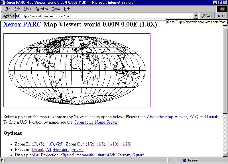
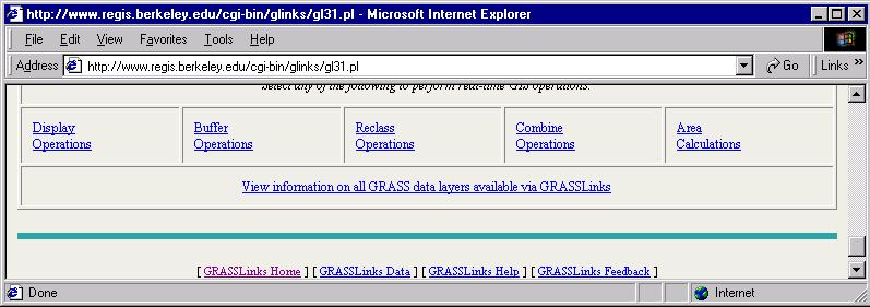
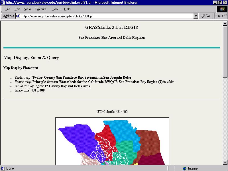
8 Development History Internet (ARPANET 1970s, TCP/IP 1983) World Wide Web (HTTP 1990, Mosaic 1993) On-line GIS The Xerox PARC Map Viewer (Putz,1994) GRASSLinks (Huse, 1995) The Alexandria Digital Library (1994) Organization The Open GIS Consortium (OGC, 1994) ISO/TC 211 (the 211 Technical Committee of the International Standards Organization, 1994)
9
10

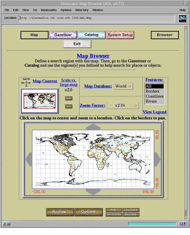
11 Alexandria Digital Library
12 Distributing the Data It must be possible to find remotely located data Data documentation, or metadata, provides the key to successful search The U.S. FGDC (Federal Geographic Data Committee) devised a much-emulated standard for geographic data description.
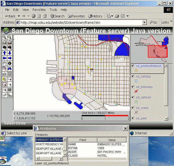
13 San Diego State University Web-based GIS (Internet GIS) Internet Map Server Web Server (map.sdsu.edu Internet Client (Web browser) + Java applets Client (Web browser) + IMS Viewer (ArcIMS) Client (Web browser) Regional Database (GIS) Server Client The Network is the Computer The Internet is your GIS.

14 The Three Faces of GIS Geographic Information Systems Geographic Information Science Geographic Information Services
15 Geographic Information Services GIServices provide a flexible and interactive tools to help users achieve their goals by browsing, searching, processing, interpreting, analyzing, and exchanging geographic information (Tsou, 2005). Services are user-oriented, customizable, and dynamic. The Internet and mobile devices are great tools to provide GIServices. (ArcIMS, Mobile GIS, Pocket PC) Network-based Information Access/Dissemination
16 Advantages of GIServices Users do not need to obtain and install expensive software Only one version of the service software need to exist (It is always the lastest version) Data used in the service can be kept constantly up to date (e.g. San Diego Traffic )
17
18 Challenges with Distributed GIServices Globalization of Information Access / Distribution How to find out the requested information? match-making (brokers) between service providers and service requestors. Decentralization of Database Management / Update How to ensure the requested data is accurate and validated?. The Integrity of GIS data sets? (Download a SD-roads dataset) Ad-hoc Technology-centered solutions: The lack of an sustainable architecture which can be upgraded to new environments and new technology.

19 HTML 5 Compatibility issues: You should install Flash, Silverlight,.Net, etc. HTML 5 will support * New Elements * New Attributes * Full CSS3 Support * Video and Audio * 2D/3D Graphics * Local Storage * Local SQL Database * Web Applications
20 Exponential Growth Value As the number of nodes in a network increases arithmetically, the value of the network increases exponentially. (Kevin Kelly, 1998, p. 23. New Rules for the New Economy) 6 (two nodes) 6+9 = 15 (Three nodes) = 28 (Four nodes) = 45 (Five nodes)


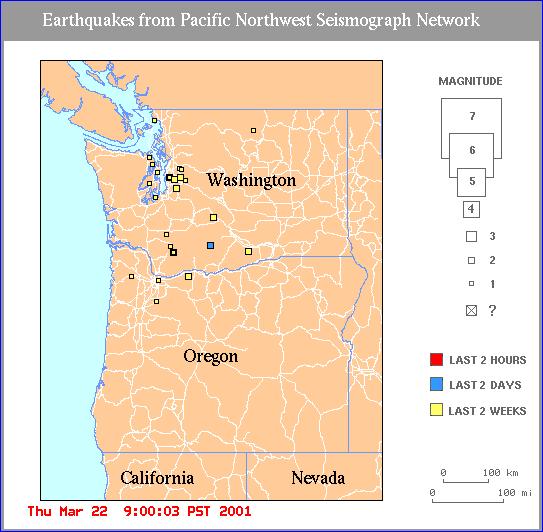
21 San Diego Wildfire 2003 & 2007 San Diego Wildfire 2003: San Diego Wildfire 2007:
.")
 WHY mobile GIS Field work: data collection and validation process, coupled with GPS and wireless communications.")
22 Mobile GIS Mobile GIS refers to an integrated software/hardware framework for the access of geospatial data and services through mobile devices via wireline or wireless networks (Tsou, 2004). (Notebooks, PDA, Tablet PC, Pocket PC, etc.) WHY mobile GIS Field work: data collection and validation process, coupled with GPS and wireless communications. Real-time update / change Global Positioning System (GPS) integration.

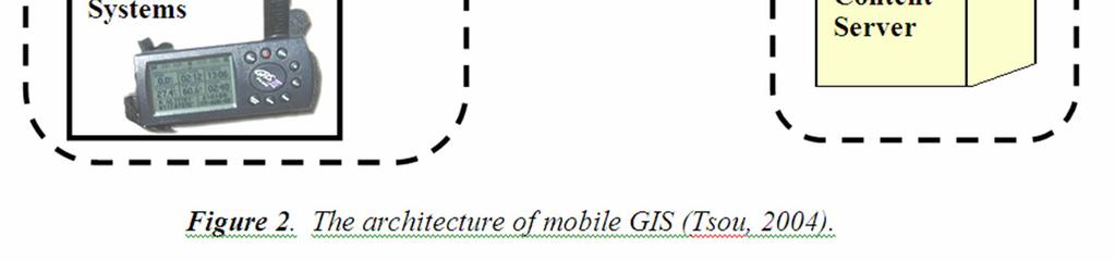
23 Mobile GIS Architecture

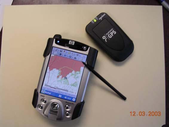
24 Wireless Mobile GIS Integration Prototype Testing (2003 at MTRP) (Notebook Web Server (IIS) + ArcPAD + Blue tooth GPS + Wi-Fi )

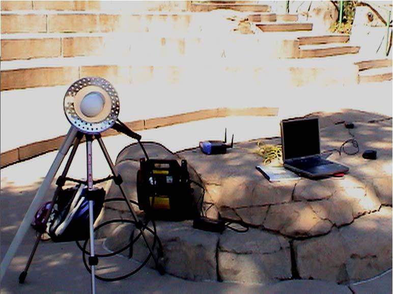
25 User Scenario: Environmental Monitoring and Management Mission Trail Regional Park (short movie) Movies shot before the 2003 Wildfire. After the Wildfire, another testing was conducted by helping the park ranger to evaluate the damages of wildfire and landform changes.
, Wi-Fi5 (802.11a, 54Mbps, 5GHz). 802.11g, and 802.11n (up to 200Mbps) -- MIMO (multiple input multiple output). Short distance: 300 feet.")
26 Wireless Local Area Network (WLAN) Wi-Fi or WiMAX Technology Different from cellular phone communication (CDMA, GPRS) Fast Transmission Speed, Good for GIS applications (large size of data/images) Wi-Fi (802.11b, 11Mbps, 2.4 Ghz), Wi-Fi5 (802.11a, 54Mbps, 5GHz) g, and n (up to 200Mbps) -- MIMO (multiple input multiple output). Short distance: 300 feet. WiMAX (available in late 2006) d, e (Wireless Metropolitan Area Network (WMAN) Mbps, 4 6 miles cf. LTE (long-term evolution)

 to")
")


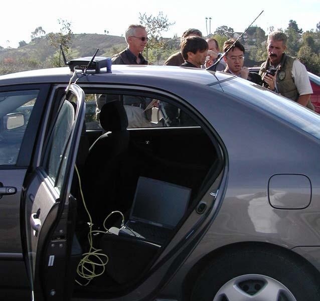
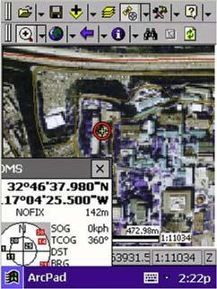
27 Real-time Data Update from Pocket PC (ArcPAD) to Internet Map Server (ArcIMS) Wireless Communication Submit new polygons (Hot-zones) from Pocket PC to Internet Map Server (ArcIMS) via Wi-Fi channel.
 Dynamically")

28 Mobile GIS with Real-time Tracking Server ESRI ArcIMS Tracking Server (beta-version) Dynamically Display the location of in-field agents (park rangers, fire fighters, etc.) -- Two way communications

")
29 Mobile GIS User Interface Simplified Mobile GIS User Interface Finger-touch Mobile GIS + voice commands (simplified user interface)

30 The Mobile User It is increasingly possible to obtain the services of a GIS through hand-held and wearable devices Some cellphones can now be used to generate maps that can be centered on the user s current location

31 Virtual Reality Use of digital technology to create an artificial visual and auditory environment that simulates the actual environment elsewhere User and subject are in different locations Technology allows the user to explore a remote location
 Google Project Glass")
32 Augmented Reality The user is in the subject location * Technology is used to augment the user s senses * Information from a database can be displayed directly in the user s field of view (superimposed on what is actually seen) Google Project Glass Video
")

33 Digital Earth (1998)
34 San Diego State University What impacts will the development of Digital Earth (3D Virtual Globe) have? Video 1 The Medium is The Message (McLuhan, 1967) (discussion in 2006 AAG session) Video 2 Video 3
35 San Diego State University Message behind the Virtual Globes Technology Is Virtual Globe/Google Earth a medium? a new medium? (Hybrid space) Evolution or Revolution? (linking to traditional GIS tools ) What Messages We Got? (a new paradigm in analyzing geospatial information?). What kinds of impacts for us? (business applications, web services, Geography awareness) The Medium is the Message
36 The Medium carries the Message (Movies are better than PowerPoint Slide!) e.g. NY Times Interactive Photos Is Virtual Globe/Google Earth a medium? a new medium? a better medium? GIS is a medium. Internet is a medium. 3D graphic is a medium. Google Earth/ArcGIS Explorer combine all together. What are the contents or concepts communicated via the Medium? Geography Awareness? GIS concepts? Protecting our watershed?
37 Everyone gets the Message! Evolution or Revolution? (linking to traditional GIS tools -- Cowen & Remington) Google Earth/Virtual Globe is an evolution from the software development perspective. ArcGlobe, Keyhole, VRML,.. Google Eath/Virtual Globe is a revolution from a general public perspective. (Why? They never see such things before! Because Google Earth is the first to combine both Data and Viewer for FREE! ) New Generation of Explorers! The Users of Google Earth/Virtual Globe are different from traditional GIS users. (on-line community, BBS, chat rooms new sub-culture? ).


38 San Diego State University Google Earth Learning Modules March 3 rd, 2006, 120 Helix High students visit our GIS labs to learn GIS and GPS technology.
39 San Diego State University The Message could be WRONG? What Messages We Got? (a new paradigm in learning and analyzing geography?). Geography is FUN! (really? Or 3D-flythrough is FUN?) and IMPORTANT? No Secrets under the Sun. (You can watch your neighbor s swimming pools or foreign nations military bases?) Locational Privacy? TRUE? or FALSE? (Out of date information?) How to update the information on Virtual Globe?) Wrong Messages? (GE/Virtual Globe is not realtime monitoring ) The World is not Flat?
40 San Diego State University What can We DO? What kinds of impacts for us? (business applications, web services,) Our Scientific Community (Delcan Butler, The Web- Wide World, Nature, vol. 439, Feb. 16, 2006). Our General Public ( disaster management, business models, location-based services, etc.) Our Geographers --??? What Geography version 2.0 means? (Alan Glennon).


41 Nature, vol. 439, Feb. 16, 2006 By Delcan Butler, The Web-Wide World,
. Integrated Mobile GIS and Wireless Internet Map Servers for Environmental Monitoring and Management, Cartography and Geographic Information Science. 31(3), pp.")
42 Related Links and References Thank You Q & A Books & Papers (PDF available upon request) Internet GIS (book) Tsou, M.H. (2004). Integrated Mobile GIS and Wireless Internet Map Servers for Environmental Monitoring and Management, Cartography and Geographic Information Science. 31(3), pp Tsou, M.H. (2004). Integrating Web-based GIS and On-line Remote Sensing Facilities for Environmental Monitoring and Management. The Journal of Geographical Systems, No. 6: 1-20.
43 How to provide Dynamic GIServices? (Tsou, Ph.D. dissertation, 2001) LEGO-Like GIS Components Operational Metadata Agent-based Communication GIS Nodes GIS Nodes GIS Nodes
44 LEGO-Like GIS Components Services Components (Programs) + Data Font and Formats Control Spell Check Control Display Component Print Preview Component Graphic User Interface Equation Editor Control Color Scheme Control Shading Control A Word Processor Package A Display Component
 System metadata GeoData Object")

45 The Design of Operational Metadata Map display component GIS-operation requirements (A, B) System metadata GeoData Object Metadata (A, B, C, D, E, F) Integrating Other GIS components GIS operation requirement are checked through the metadata Self-describing Self-managing
46 Agent-based Communication GIS Components Metadata Geodata Objects Metadata Agents Info. finders/filters Interpreters Decision makers Knowledge bases + User-defined rules
47 Build GIServices on-the-fly GIS user (Mike) Dynamic Construction (on the Internet) User Scenario: Map Display [Colorado Roads] A GIS node B C Geodata object GIS component
by Dr. Ming-Hsiang (Ming) Tsou Associate Professor Internet-based Mapping is a new form (medium) of maps in cartography and for geographic research.
 Tsou Associate Professor Internet-based Mapping is a new form (medium) of maps in cartography and for geographic research.") San Diego State University GEOG 104 Class New Research Directions of Internet GIS and Disaster Management and Lessons Learned from the San Diego 2007 Wildfires. Technology Advancement by Dr. Ming-Hsiang
San Diego State University GEOG 104 Class New Research Directions of Internet GIS and Disaster Management and Lessons Learned from the San Diego 2007 Wildfires. Technology Advancement by Dr. Ming-Hsiang
Cartographic and Geospatial Futures
 Cartographic and Geospatial Futures 1. Web Cartography, WebGIS, & Virtual Globes--New Roles for Maps, GIS, and GIS professionals 2. Map Mashups, the Neo Neo-geography Movement, & Crowd-sourcing Geospatial
Why GIS & Why Internet GIS?
 Why GIS & Why Internet GIS? The Internet bandwagon Internet mapping (e.g., MapQuest) Location-based services Real-time navigation (e.g., traffic) Real-time service dispatch Business Intelligence Spatial
A Model of GIS Interoperability Based on JavaRMI
 A Model of GIS Interoperability Based on Java Gao Gang-yi 1 Chen Hai-bo 2 1 Zhejiang University of Finance & Economics, Hangzhou 310018, China 2 College of Computer Science and Technology, Zhejiang UniversityHangzhou
Introduction to ArcGIS Server Development
 Introduction to ArcGIS Server Development Kevin Deege,, Rob Burke, Kelly Hutchins, and Sathya Prasad ESRI Developer Summit 2008 1 Schedule Introduction to ArcGIS Server Rob and Kevin Questions Break 2:15
Paper UC1351. Conference: User Conference Date: 08/10/2006 Time: 8:30am-9:45am Room: Room 23-B (SDCC)
") Conference: User Conference Date: 08/10/2006 Time: 8:30am-9:45am Room: Room 23-B (SDCC) Title of Paper: Increasing the Use of GIS in the Federal Government Author Name: Miss Abstract This presentation
Conference: User Conference Date: 08/10/2006 Time: 8:30am-9:45am Room: Room 23-B (SDCC) Title of Paper: Increasing the Use of GIS in the Federal Government Author Name: Miss Abstract This presentation
PaikkaOppi - a Virtual Learning Environment on Geographic Information for Upper Secondary School
 PaikkaOppi - a Virtual Learning Environment on Geographic Information for Upper Secondary School Jaakko Kähkönen*, Lassi Lehto*, Juha Riihelä** * Finnish Geodetic Institute, PO Box 15, FI-02431 Masala,
Chapter 10: The Future of GIS Why Speculate? 10.2 Future Data 10.3 Future Hardware 10.4 Future Software 10.5 Some Future Issues and Problems
 Chapter 10: The Future of GIS 10.1 Why Speculate? 10.2 Future Data 10.3 Future Hardware 10.4 Future Software 10.5 Some Future Issues and Problems Theme of the Course GIS's place in understanding geographic
A Technique for Importing Shapefile to Mobile Device in a Distributed System Environment.
 A Technique for Importing Shapefile to Mobile Device in a Distributed System Environment. 1 Manish Srivastava, 2 Atul Verma, 3 Kanika Gupta 1 Academy of Business Engineering and Sciences,Ghaziabad, 201001,India
Discovery and Access of Geospatial Resources using the Geoportal Extension. Marten Hogeweg Geoportal Extension Product Manager
 Discovery and Access of Geospatial Resources using the Geoportal Extension Marten Hogeweg Geoportal Extension Product Manager DISCOVERY AND ACCESS USING THE GEOPORTAL EXTENSION Geospatial Data Is Very
ArcGIS. for Server. Understanding our World
 ArcGIS for Server Understanding our World ArcGIS for Server Create, Distribute, and Manage GIS Services You can use ArcGIS for Server to create services from your mapping and geographic information system
Chapter 12 Mobile GIServices Applied to Disaster Management
 Chapter 12 Mobile GIServices Applied to Disaster Management 12.1 Introduction Ming-Hsiang Tsou 1 and Chih-Hong Sun 2 1 Department of Geography, San Diego State University 2 Department of Geography, National
CARTOGRAPHY in a Web World
 CARTOGRAPHY in a Web World Nationale GI Minor BAREND KÖBBEN b.j.kobben@utwente.nl Agenda Short introduction to ITC and me Cartography: communicating spatial data Changing GIS & Cartography technology:
You are Building Your Organization s Geographic Knowledge
 You are Building Your Organization s Geographic Knowledge And Increasingly Making it Available Sharing Data Publishing Maps and Geo-Apps Developing Collaborative Approaches Citizens Knowledge Workers Analysts
Innovation. The Push and Pull at ESRI. September Kevin Daugherty Cadastral/Land Records Industry Solutions Manager
 Innovation The Push and Pull at ESRI September 2004 Kevin Daugherty Cadastral/Land Records Industry Solutions Manager The Push and The Pull The Push is the information technology that drives research and
Introduction to ArcGIS Server - Creating and Using GIS Services. Mark Ho Instructor Washington, DC
 Introduction to ArcGIS Server - Creating and Using GIS Services Mark Ho Instructor Washington, DC Technical Workshop Road Map Product overview Building server applications GIS services Developer Help resources
Global 3D Models with Local Content
 Gunnar Misund Associate Professor Head of Environmental Computing gunnar.misund@hiof.no - Morten Granlund, Scientfic Assistant Herman Kolås, Master Student Mats Lindh, Master Student - Østfold University
The Emerging Role of Enterprise GIS in State Forest Agencies
 The Emerging Role of Enterprise GIS in State Forest Agencies Geographic Information System (GIS) A geographic information system (GIS) is a computer software system designed to capture, store, manipulate,
FUTURE DATA. Future data Future hardware Future software Future issues. Getting Started With GIS. Chapter 10
 THE FUTURE OF GIS Getting Started With GIS Chapter 10 GIS Futures Future data Future hardware Future software Future issues Dursun Z. ªeker Theme of the book GIS's place in understanding geographic distributions
Using OGC standards to improve the common
 Using OGC standards to improve the common operational picture Abstract A "Common Operational Picture", or a, is a single identical display of relevant operational information shared by many users. The
Modern Education at Universities: Improvements through the Integration of a Spatial Data Infrastructure SDI into an e-learning Environment
 Modern Education at Universities: Improvements through the Integration of a Spatial Data Infrastructure SDI into an e-learning Environment Ingo Simonis Institute for Geoinformatics, University of Muenster
CHAPTER 48. The Integration of Internet GIS and Wireless Mobile GIS. Ming-Hsiang Tsou Introduction
 48.1 Introduction CHAPTER 48 The Integration of Internet GIS and Wireless Mobile GIS Ming-Hsiang Tsou The paradigm of geographic information systems (GISs) is shifting from a closed, centralized GIS architecture,
CARTOGRAPHY in a Web World
 CARTOGRAPHY in a Web World SENSE Research Cluster XIII meeting: Concepts and tools for spatial data visualization BAREND KÖBBEN kobben@itc.nl b.j.kobben@utwente.nl Agenda Short introduction to ITC and
Display data in a map-like format so that geographic patterns and interrelationships are visible
 Vilmaliz Rodríguez Guzmán M.S. Student, Department of Geology University of Puerto Rico at Mayagüez Remote Sensing and Geographic Information Systems (GIS) Reference: James B. Campbell. Introduction to
ESRI Survey Summit August Clint Brown Director of ESRI Software Products
 ESRI Survey Summit August 2006 Clint Brown Director of ESRI Software Products Cadastral Fabric How does Cadastral fit with Survey? Surveyors process raw field observations Survey measurements define high-order
FREIS: A WEB-BASED RESOURCES AND ENVIRONMENT INFORMATION SYSTEM FOR AGRO-ECOSYSTEM MANAGEMENT
 FREIS: A WEB-BASED RESOURCES AND ENVIRONMENT INFORMATION SYSTEM FOR AGRO-ECOSYSTEM MANAGEMENT Mingxin Men *, Yuepu Qi, Boyang Du, Hao Xu College of Agricultural Resources and Environmental Sciences, Hebei
WEB-BASED SPATIAL DECISION SUPPORT: TECHNICAL FOUNDATIONS AND APPLICATIONS
 WEB-BASED SPATIAL DECISION SUPPORT: TECHNICAL FOUNDATIONS AND APPLICATIONS Claus Rinner University of Muenster, Germany Piotr Jankowski San Diego State University, USA Keywords: geographic information
What is GIS? G: Geographic, Geospatial, Geo
 GEOG 488/588: GIS I Introduction Instructor: Geoffrey Duh TA: David Graves What is GIS? G: Geographic, Geospatial, Geo Alternatives: Spatial Information Systems, Land Information Systems Geography diverse
Imagery and the Location-enabled Platform in State and Local Government
 Imagery and the Location-enabled Platform in State and Local Government Fred Limp, Director, CAST Jim Farley, Vice President, Leica Geosystems Oracle Spatial Users Group Denver, March 10, 2005 TM TM Discussion
Lesson 16: Technology Trends and Research
 http://www.esri.com/library/whitepapers/pdfs/integrated-geoenabled-soa.pdf GEOG DL582 : GIS Data Management Lesson 16: Technology Trends and Research Overview Learning Objective Questions: 1. Why is integration
Web-GIS based Framework for Solid Waste Complaint Management for Sustainable and Smart City
 Cloud Publications International Journal of Advanced Remote Sensing and GIS 2016, Volume 5, Issue 10, pp. 1930-1936 ISSN 2320-0243, DOI: 10.23953/cloud.ijarsg.71 Research Article Open Access Web-GIS based
How does ArcGIS Server integrate into an Enterprise Environment? Willy Lynch Mining Industry Specialist ESRI, Denver, Colorado USA
 How does ArcGIS Server integrate into an Enterprise Environment? Willy Lynch Mining Industry Specialist ESRI, Denver, Colorado USA wlynch@esri.com ArcGIS Server Technology Transfer 1 Agenda Who is ESRI?
Smart Data Collection and Real-time Digital Cartography
 Smart Data Collection and Real-time Digital Cartography Yuji Murayama and Ko Ko Lwin Division of Spatial Information Science Faculty of Life and Environmental Sciences University of Tsukuba IGU 2013 1
Techniques for Science Teachers: Using GIS in Science Classrooms.
 Techniques for Science Teachers: Using GIS in Science Classrooms. After ESRI, 2008 GIS A Geographic Information System A collection of computer hardware, software, and geographic data used together for
Technical Trends in Geo Information
 Technical Trends in Geo Information Joachim WIESEL 1 Introduction Geo Information Systems as a small part of the IT-Industry is a fast changing technology, driven by market demands and technical advances.
Advanced Algorithms for Geographic Information Systems CPSC 695
 Advanced Algorithms for Geographic Information Systems CPSC 695 Think about Geography What is Geography The 3 W s of Geography What is where Why is it there Why do I care Data - Data - Data We all got
NR402 GIS Applications in Natural Resources
 NR402 GIS Applications in Natural Resources Lesson 1 Introduction to GIS Eva Strand, University of Idaho Map of the Pacific Northwest from http://www.or.blm.gov/gis/ Welcome to NR402 GIS Applications in
Crime Analyst Extension. Christine Charles
 Crime Analyst Extension Christine Charles ccharles@esricanada.com Agenda Why use Crime Analyst? Overview Tools Demo Interoperability With our old software it could take a police officer up to forty minutes
Write a report (6-7 pages, double space) on some examples of Internet Applications. You can choose only ONE of the following application areas:
 on some examples of Internet Applications. You can choose only ONE of the following application areas:") UPR 6905 Internet GIS Homework 1 Yong Hong Guo September 9, 2008 Write a report (6-7 pages, double space) on some examples of Internet Applications. You can choose only ONE of the following application
UPR 6905 Internet GIS Homework 1 Yong Hong Guo September 9, 2008 Write a report (6-7 pages, double space) on some examples of Internet Applications. You can choose only ONE of the following application
Your web browser (Safari 7) is out of date. For more security, comfort and. the best experience on this site: Update your browser Ignore
 is out of date. For more security, comfort and. the best experience on this site: Update your browser Ignore") Your web browser (Safari 7) is out of date. For more security, comfort and Activityengage the best experience on this site: Update your browser Ignore Introduction to GIS What is a geographic information
Your web browser (Safari 7) is out of date. For more security, comfort and Activityengage the best experience on this site: Update your browser Ignore Introduction to GIS What is a geographic information
United States Forest Service Makes Use of Avenza PDF Maps App to Reduce Critical Time Delays and Increase Response Time During Natural Disasters
 CASE STUDY For more information, please contact: Christine Simmons LFPR Public Relations www.lfpr.com (for Avenza) 949.502-7750 ext. 270 Christines@lf-pr.com United States Forest Service Makes Use of Avenza
TRAITS to put you on the map
 TRAITS to put you on the map Know what s where See the big picture Connect the dots Get it right Use where to say WOW Look around Spread the word Make it yours Finding your way Location is associated with
Personal Field Data Collection by UM-FieldGIS (Integration of Google Map API to Mobile GIS)
") Personal Field Data Collection by UM-FieldGIS (Integration of Google Map API to Mobile GIS) Ko Ko Lwin*. Yuji MURAYAMA* *Division of Spatial Information Science Graduate School of Life and Environmental
Personal Field Data Collection by UM-FieldGIS (Integration of Google Map API to Mobile GIS) Ko Ko Lwin*. Yuji MURAYAMA* *Division of Spatial Information Science Graduate School of Life and Environmental
GIS CONCEPTS Part I. GIS ON THE WEB Part II
 Week 2 GIS CONCEPTS Part I GIS ON THE WEB Part II topics of the week part I GIS functions and GIS data Spatial relationships Organizing convention for spatial data Store Information by thematic layers
Web Visualization of Geo-Spatial Data using SVG and VRML/X3D
 Web Visualization of Geo-Spatial Data using SVG and VRML/X3D Jianghui Ying Falls Church, VA 22043, USA jying@vt.edu Denis Gračanin Blacksburg, VA 24061, USA gracanin@vt.edu Chang-Tien Lu Falls Church,
Business Model for sustainable regional development by tourism
 Business Model for sustainable regional development by tourism Why EuroVeloPark Banat? Steps to Success Action proposal 1. Drawing of the Basis Map 2. Data Acquisition, POIs, etc. 3. Printed Map and Distribution
How to Pick a GIS. GIS Software Chapter 8 in Longley, Goodchild, Maguire, and Rhind,, 2001
 How to Pick a GIS GIS Software Chapter 8 in Longley, Goodchild, Maguire, and Rhind,, 2001 How to Pick a GIS Evolution of GIS software Architecture of GIS software Types of software Example products The
July 5-6, 2010 Mytilene, Greece
 Web GIS platform for forest fire management Prof. Kostas Kalabokidis Principal Investigator Univ. of the Aegean, Dept. of Geography, Greece Prof. George Kallos Univ. of Athens, Dept. of Physics, Greece
Introduction to GIS. Geol 4048 Geological Applications of Remote Sensing
 Introduction to GIS Geol 4048 Geological Applications of Remote Sensing GIS History: Before Computers GIS History Using maps for a long time Dr. Roger F. Tomlinson Father of GIS He was an English geographer
Counter-trafficking Integrated Display System (CIDS): A GIS-Based Command & Control Environment for Coalition Nations
: A GIS-Based Command & Control Environment for Coalition Nations") 9 th International Command and Control Research and Technology Symposium Counter-trafficking Integrated Display System (CIDS): A GIS-Based Command & Control Environment for Coalition Nations Elizabeth
9 th International Command and Control Research and Technology Symposium Counter-trafficking Integrated Display System (CIDS): A GIS-Based Command & Control Environment for Coalition Nations Elizabeth
Brian D. George. GIMS Specialist Ohio Coastal Atlas Project Coordinator and Cartographer. Impacts and Outcomes of Mature Coastal Web Atlases
 Ohio Coastal Atlas Project Brian D. George GIMS Specialist Ohio Coastal Atlas Project Coordinator and Cartographer Ohio Department of Natural Resources Office of Coastal Management Sandusky, OH Impacts
UNIT 4: USING ArcGIS. Instructor: Emmanuel K. Appiah-Adjei (PhD) Department of Geological Engineering KNUST, Kumasi
 Department of Geological Engineering KNUST, Kumasi") UNIT 4: USING ArcGIS Instructor: Emmanuel K. Appiah-Adjei (PhD) Department of Geological Engineering KNUST, Kumasi Getting to Know ArcGIS ArcGIS is an integrated collection of GIS software products ArcGIS
UNIT 4: USING ArcGIS Instructor: Emmanuel K. Appiah-Adjei (PhD) Department of Geological Engineering KNUST, Kumasi Getting to Know ArcGIS ArcGIS is an integrated collection of GIS software products ArcGIS
Developing An Application For M-GIS To Access Geoserver Through Mobile For Importing Shapefile
 Developing An Application For M-GIS To Access Geoserver Through Mobile For Importing Shapefile Ritik Sharma,A,1, Shubhangi Garg B,2, Yogesh Kumar c,3, Jeevash Mutreja d,4 a ABES Engg.College Ghaziabad
Urban Planning Internet Geographic Information Systems Fall 2010
 Urban Planning - 794 Internet Geographic Information Systems Fall 2010 Instructor: Professor Huxhold (hux@uwm.edu) Lecturer: Melissa Mann (mmann@uwm.edu) Manager: Kurt Meingast (kurtm@uwm.edu) Schedule:
Canadian Board of Examiners for Professional Surveyors Core Syllabus Item C 5: GEOSPATIAL INFORMATION SYSTEMS
 Study Guide: Canadian Board of Examiners for Professional Surveyors Core Syllabus Item C 5: GEOSPATIAL INFORMATION SYSTEMS This guide presents some study questions with specific referral to the essential
Portals: Standards in Action
 Portals: Standards in Action David Danko ISO TC 211 Metadata Project Leader GIS Standards Consultant-ESRI. Metadata Portals Portal gateway, place of entry Producers Advertise, expose products Share information
A Geographer s role in a Google Maps World. Jeremy Bartley ESRI
 A Geographer s role in a Google Maps World Jeremy Bartley ESRI 1 It is a good time to be a Geographer. 2 Microsoft, Google, Yahoo, and others are pushing geographic awareness to the general public Providing
Develop a Spatial Information Management System: A Case Study for Faculty of Agriculture, University of Ruhuna, Sri Lanka
 Develop a Spatial Information Management System: A Case Study for Faculty of Agriculture, University of Ruhuna, Sri Lanka Prabath Priyankara 1*, Upul Indika 2 and Dimuthu Piyaratne 1 1 Computer Unit, Faculty
Key Points Sharing fosters participation and collaboration Metadata has a big role in sharing Sharing is not always easy
 Sharing Resources Geoff Mortson esri, Inc. SDI Solutions Team Key Points Sharing fosters participation and collaboration Metadata has a big role in sharing Sharing is not always easy Data Sharing is Good
ENV208/ENV508 Applied GIS. Week 1: What is GIS?
 ENV208/ENV508 Applied GIS Week 1: What is GIS? 1 WHAT IS GIS? A GIS integrates hardware, software, and data for capturing, managing, analyzing, and displaying all forms of geographically referenced information.
Creation of an Internet Based Indiana Water Quality Atlas (IWQA)
") Department of Environmental Management Creation of an Internet Based Water Quality Atlas (IWQA) May 4, 2005 IUPUI 1200 Waterway Blvd., Suite 100 polis, 46202-5140 Water Quality Atlas John Buechler, Neil
Department of Environmental Management Creation of an Internet Based Water Quality Atlas (IWQA) May 4, 2005 IUPUI 1200 Waterway Blvd., Suite 100 polis, 46202-5140 Water Quality Atlas John Buechler, Neil
Introduction to the 176A labs and ArcGIS
 Introduction to the 176A labs and ArcGIS Acknowledgement: Slides by David Maidment, U Texas-Austin and Francisco Olivera (TAMU) Purpose of the labs Hands-on experience with one software pakage Introduction
Steve Pietersen Office Telephone No
 Steve Pietersen Steve.Pieterson@durban.gov.za Office Telephone No. 031 311 8655 Overview Why geography matters The power of GIS EWS GIS water stats EWS GIS sanitation stats How to build a GIS system EWS
Geographical Information System GIS
 Geographical Information System GIS LOOM.02.331 anto.aasa@ut.ee Scale GIS and spatial planning National Regional Local Strategic (National Dev. Plan) National Goals and development policy Tactical (Regional
Water Data Sharing an Update
 Water Data Sharing an Update By David R. Maidment Leader, CUAHSI Hydrologic Information System Project and Director, Center for Research in Water Resources, University of Texas at Austin Prepared for Subcommittee
What is GIS and How Can It Help Me?
 esri European User Conference Madrid 2011 What is GIS and How Can It Help Me? Jaime Nieves Ignacio Vázquez esri spain «Knowing where things are, and why, is essential to rational decision making.» Jack
Geo Business Gis In The Digital Organization
 We have made it easy for you to find a PDF Ebooks without any digging. And by having access to our ebooks online or by storing it on your computer, you have convenient answers with geo business gis in
Lecture 12. Data Standards and Quality & New Developments in GIS
 Lecture 12 Data Standards and Quality & New Developments in GIS Lecture 12: Outline I. Data Standards and Quality 1. Types of Spatial Data Standards 2. Data Accuracy 3. III. Documenting Spatial Data Accuracy
GENERALIZATION IN THE NEW GENERATION OF GIS. Dan Lee ESRI, Inc. 380 New York Street Redlands, CA USA Fax:
 GENERALIZATION IN THE NEW GENERATION OF GIS Dan Lee ESRI, Inc. 380 New York Street Redlands, CA 92373 USA dlee@esri.com Fax: 909-793-5953 Abstract In the research and development of automated map generalization,
OSGIS Platform. Storing and distributing PostGIS, Deegree, UMN Map Server Desktop visualization JUMP, QGIS, Thuban, udig, gvsig
 GIS groups of tasks Geodata collecting, updating Geodata storing and distributing Geodata analysis Geodata visualization: Desktop, Internet, Printing Geodata describing: metadata management Geodata converting:
GIS = Geographic Information Systems;
 What is GIS GIS = Geographic Information Systems; What Information are we talking about? Information about anything that has a place (e.g. locations of features, address of people) on Earth s surface,
These modules are covered with a brief information and practical in ArcGIS Software and open source software also like QGIS, ILWIS.
 Online GIS Training and training modules covered are: 1. ArcGIS, Analysis, Fundamentals and Implementation 2. ArcGIS Web Data Sharing 3. ArcGIS for Desktop 4. ArcGIS for Server These modules are covered
Information. Information Technology. Geographic. Services (GIS) 119 W Indiana Ave Deland, FL 32720
 119 W Indiana Ave Deland, FL 32720") Information Technology Geographic Information Services (GIS) 119 W Indiana Ave Deland, FL 32720 A GIS consists of 5 primary components: Hardware Software People Data Methods or Business Processes --- Hardware
Information Technology Geographic Information Services (GIS) 119 W Indiana Ave Deland, FL 32720 A GIS consists of 5 primary components: Hardware Software People Data Methods or Business Processes --- Hardware
Continental Divide National Scenic Trail GIS Program
 CDNST Vision Statement: Provide the most accurate geospatial locational information of the Continental Divide Trail and nearby resources to the public as well as help provide internal management information
OGC GEOPACKAGE AND HOW OPEN SOURCE IS CHANGING THE WAY GOVERNMENTS THINK ABOUT STANDARDS. Nathan Frantz Geospatial Research Lab
 OGC GEOPACKAGE AND HOW OPEN SOURCE IS CHANGING THE WAY GOVERNMENTS THINK ABOUT STANDARDS Nathan Frantz Geospatial Research Lab Dr. Ben Tuttle National Geospatial-Intelligence Agency FOSS4G 2015 Geospatial
Introduction to the 176A labs and ArcGIS Purpose of the labs
 Introduction to the 176A labs and ArcGIS Purpose of the labs Acknowledgement: Slides by David Maidment, U Texas-Austin and Francisco Olivera (TAMU) Hands-on experience with a leading software package Introduction
Abstract. Interoperable Framework for Mobile Dynamic Surveying based on open source components
 Interoperable Framework for Mobile Dynamic Surveying based on open source components Sergiusz Pawlowicz, Didier Leibovici, Richard Saull±, Mike Jackson, Chaoyu Ye, Wenchao Jiang, Natalie Adams 1, Suchith
4D information management system for road maintenance using GIS
 icccbe 2010 Nottingham University Press Proceedings of the International Conference on Computing in Civil and Building Engineering W Tizani (Editor) 4D information management system for road maintenance
GERSVIEW: A New Database for Web Mapping
 GERSVIEW: A New Database for Web Mapping William J. Hernández, M.S. Graduate Student Department of Marine Sciences-UPRM Fernando Gilbes, Ph.D. Associate Professor Department of Geology-UPRM Overview Introduction
SERVICE-BASED APPROACH TO GEOPORTALS ARCHITECTURE
 SERVICE-BASED APPROACH TO GEOPORTALS ARCHITECTURE Evgeny Panidi Saint-Petersburg State University Saint-Petersburg, Russia, panidi@yandex.ru Abstract. This paper describes the author s view on service-based
How local communities could profit from Habitats infrastructure
 Social Validation of INSPIRE Annex III Data Structures in EU Habitats How local communities could profit from Habitats infrastructure Andrea Scianna ( Icar CNR Italy ) consultant for Madonie Park Authority
GEOGRAPHIC INFORMATION SYSTEMS Session 8
 GEOGRAPHIC INFORMATION SYSTEMS Session 8 Introduction Geography underpins all activities associated with a census Census geography is essential to plan and manage fieldwork as well as to report results
Introduction to Geographic Information Systems Dr. Arun K Saraf Department of Earth Sciences Indian Institute of Technology, Roorkee
 Introduction to Geographic Information Systems Dr. Arun K Saraf Department of Earth Sciences Indian Institute of Technology, Roorkee Lecture 01 What is Geographic Information Systems? I welcome to this
SDI Standards at work
 SDI Standards at work Jan Juul Jensen Senior Technology Strategist Informi GIS Denmark Informi GIS Private held Limited Company Specialized in GIS 100+ employees HQ in Charlottenlund, Copenhagen Regional
Corporate. Information. Railway Infrastructure Administrator. Year indracompany.com
 geospatial and mobility Corporate Geographic Information System of ADIF Railway Infrastructure Administrator. Year 2009-2010 Corporate Geographic Information System of ADIF ADIF. Spanish Administrator
Digital Tax Maps Westport Island Project Summary
 Digital Tax Maps Westport Island Project Summary Presented to the: Mid-Coast Regional Planning Commission Creating GIS-Based Digital Tax Maps And Linked Assessment Records For Small Towns on a Budget Dennis
Esri Overview for Mentor Protégé Program:
 Agenda Passionate About Helping You Succeed Esri Overview for Mentor Protégé Program: Northrop Grumman CSSS Jeff Dawley 3 September 2010 Esri Overview ArcGIS as a System ArcGIS 10 - Map Production - Mobile
Overview of Geospatial Open Source Software which is Robust, Feature Rich and Standards Compliant
 Overview of Geospatial Open Source Software which is Robust, Feature Rich and Standards Compliant Cameron SHORTER, Australia Key words: Open Source Geospatial Foundation, OSGeo, Open Standards, Open Geospatial
All About Spatial Data. Find it, Manage it, Use it
 All About Spatial Data Find it, Manage it, Use it Workshop Outline Define spatial data Spatial data formats Data Sources Metadata Evaluating Spatial Data Data Management Activities: define spatial data,
GIS at UCAR. The evolution of NCAR s GIS Initiative. Olga Wilhelmi ESIG-NCAR Unidata Workshop 24 June, 2003
 GIS at UCAR The evolution of NCAR s GIS Initiative Olga Wilhelmi ESIG-NCAR Unidata Workshop 24 June, 2003 Why GIS? z z z z More questions about various climatological, meteorological, hydrological and
Geometric Algorithms in GIS
 Geometric Algorithms in GIS GIS Visualization Software Dr. M. Gavrilova GIS Software for Visualization ArcView GEO/SQL Digital Atmosphere AutoDesk Visual_Data GeoMedia GeoExpress CAVE? Visualization in
Applying Internet Geographic Information System for Water Quality Monitoring
 Geography Compass 1/6 (2007): 1315 1337, 10.1111/j.1749-8198.2007.00065.x Applying Internet Geographic Information System for Water Quality Monitoring Piotr Jankowski*, Ming-Hsiang Tsou and Richard D.
IH 35 at Blanco River May 2015
 IH 35 at Blanco River May 2015 Presentation Objectives Background of historical damage assessment processes Introduction to Collector App ( Mat Peck) Collector App and Flood Damage Assessment (Katie Steele)
Working with Temporal Data in ArcGIS
 Working with Temporal Data in ArcGIS By Aileen Buckley, Esri Research Cartographer Time is an important dimension in many types of geospatial visualizations and analyses. The temporal aspect adds when
STEREO ANALYST FOR ERDAS IMAGINE Stereo Feature Collection for the GIS Professional
 STEREO ANALYST FOR ERDAS IMAGINE Stereo Feature Collection for the GIS Professional STEREO ANALYST FOR ERDAS IMAGINE Has Your GIS Gone Flat? Hexagon Geospatial takes three-dimensional geographic imaging
DP Project Development Pvt. Ltd.
 Dear Sir/Madam, Greetings!!! Thanks for contacting DP Project Development for your training requirement. DP Project Development is leading professional training provider in GIS technologies and GIS application
NOKIS - Information Infrastructure for the North and Baltic Sea
 NOKIS - Information Infrastructure for the North and Baltic Sea Carsten Heidmann 1 and Jörn Kohlus 2 Abstract 1. General The initial motivation for the project NOKIS (German title: Nord- und Ostsee-Küsteninformationssystem)
Cutting Edge Engineering for Modern Geospatial Systems Rear Admiral Dr. S Kulshrestha, retd
 Cutting Edge Engineering for Modern Geospatial Systems Rear Admiral Dr. S Kulshrestha, retd 11 Jun 2015 GeoIntelligence Asia 2015 The technology would become so pervasive that it becomes a part of you
How a Media Organization Tackles the. Challenge Opportunity. Digital Gazetteer Workshop December 8, 2006
 A Case-Study-In-Process: How a Media Organization Tackles the Georeferencing Challenge Opportunity Digital Gazetteer Workshop December 8, 2006 to increase and diffuse geographic knowledge 1888 to 2006:
This Week is All About GIS, Geography and Sharing Our Knowledge
 Stockholm 2007 1 This Week is All About GIS, Geography and Sharing Our Knowledge Technology Methods Organization Data Processes Standards Projects Visualization And About You Applications Mapping Data