Error propagation models dlto examine the effects of geocoding quality on spatial analysis of individual level datasets
|
|
|
- Amelia Beasley
- 5 years ago
- Views:
Transcription
1 Error propagation models dlto examine the effects of geocoding quality on spatial analysis of individual level datasets P.A. Zandbergen 1, T.C. Hart 2, K.E. Lenzer 1 and M.E. Camponovo 1 1 Department tof Geography, University it of New Mexico 2 Department of Criminal Justice, University of Nevada Las Vegas
2 Outline Quality of geocoding Error propagation modeling Model specific for geocoding Three case studies
3 Quality Metrics of Geocoding Positional accuracy Distance between geocoded and true location Completeness Match rate (%) Repeatability /replicability Agreement across reference data, algorithms Usefulness Quality metrics vs. intended use
4 Typical Error Distribution Cumulative Freq quency (%) N =104,865 school children in Orange County, FL ,000 Positional Error (m) Zandbergen, P.A Influence of geocoding quality on environmental exposure assessment of children living near high traffic roads. BMC Public Health, 7:37.
5 Typical Errors Statistic Value (m) Min 1 Max 32,356 Mean 66 SD 435 Median th % th % th % 373 N 104,865 Expected Normal Log-normalized Q-Q plot Observed Value Based on the 90 th percentile, typical street geocoding does not meet the accuracy standards for a 1:100,000 scale map based on National Map Accuracy Standards! Zandbergen, P.A Influence of geocoding quality on environmental exposure assessment of children living near high traffic roads. BMC Public Health, 7:37.


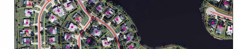
6 Actual Building vs. Street Geocoded
7 It Gets Messy
8 Positional Accuracy of Geocoding 1. Varies strongly across urban rural gradients 2. Direction not uniform but follows reference data 3. Distribution does not follow a normal distribution 4. Spatial autocorrelated with reference data This complicates error propagation modeling using traditional Monte Carlo simulation


9 Error term Original DEM Error DEM + Stream Probability Streams


10 Error Propagation Model Focus on positional accuracy Reference scenario based on address points

11
12 Case study study Example 1. Point in raster overlay 2. Kernel density hotspots 3. Point in polygon overlay
13 Case study study 1: Point in raster Overlay Study areas: Clay County, MN; Jackson County, OR; New Hannover County, NC; San Francisco County, CA; Travis County, TX; and Washington, DC 2006 National Land Cover Data Original classes Reclassified into urban, suburban, rural Sample of 1,000 residential address points per study area Geocoded using StreetMap USA 2009 Error matrices for land cover associations
14
15 Geocoded Locations (StreetMap USA) open water developed, open space developed, low intensity developed, medium i t it developed, high intensity barren land (rock/sand/clay) deciduous forest evergreen forest m ixed forest shrub/scrub gr assland/her pasture/hay cultivated crops woody wetlan to tal baceous ds open water 1 1 developed, open space developed, low intensity developed, medium intensity developed, high intensity barren land (rock/sand/clay) 0 deciduous forest 2 2 evergreen forest mixed forest shrub/scrub grassland/herbaceous pasture/hay cultivated crops woody wetlands total Reference Locations
16 Land Cover Results Clay, MN Jackson, OR New Hannover, NC San Fran., CA Travis, TX Wash., DC Pop. density (#/ sq. mile) , ,379.4 Detailed land cover accuracy (%) unweighted kappa weighted kappa Urban/suburban/rural accuracy (%) unweighted kappa weighted kappa
17 Case study study 2: Kernel Density Hotspots Study area: Charlotte, NC Crime data: Assaults for 2008 Geocoding techniques: Address points Local Street Centerlines TeleAtlas StreetMap USA 2009 Kernel density hotspot analysis: 100, 200, 300, 400 and 500 m Boundary error analysis


 / A A")

18 Measurement of Hotspot Boundary Error Reference Hotspot Street Geocoded Comparison FN A FP Boundary Error = (FP + FN) / A A = Agreement FN = False Negative FP = False Positive
19 Kernel Geocoding Method Area of Area of False Area of False (FN+FP)/A bandwidth Agreement (A) (km2) Negative (FN) (km2) Positive (FP) (km2) 100 m Local Street Centerlines TeleAtlas StreetMap USA m Local Street Centerlines TeleAtlas StreetMap USA m Local Street Centerlines TeleAtlas StreetMap USA m Local Street Centerlines TeleAtlas StreetMap USA m Local Street Centerlines TeleAtlas StreetMap USA
20
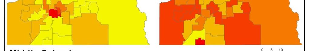
21 Case study study 3: Point in Polygon Polygon Study area: Orange County, FL Datasets: enrollment records of public schools (n= 120,222) Geocoding techniques: Address points Local Street Centerlines TIGER 2000 Point in polygon overlay: Elementary, middle and high schools % incorrectly assigned Results split by race/ethnicity
22 Point in Polygon Polygon Results % Error Asian Black Hispanic White Total Elementary schools ( n= 2,021) (n = 18,330) (n = 18,218) (n = 21,350) (n = 59,919) Street Centerlines TIGER Middle schools (n = 1,023 ) (n = 8,464) (n = 8,104) (n = 10,938) (n = 28,529) Street Centerlines TIGER High schools (n = 1,395) (n = 8,501) (n = 7,997) (n = 13,781) (n = 31,674) Street Centerlines TIGER


23
24 Summary Results Case study 1: Land cover associations iti Substantial errors 5 to 50% Varies with land cover heterogeneity Case study 2: Kernel density hotspots Substantial errors at large scales Bandwidth key parameter Limited effect of geocoding type Case study 3: Point in polygon Moderate errors few > 5% Varies with polygon on size Strong effect of geocoding type
25 Error Propagation Model Strengths: th No assumptions about the nature of positional error Relatively simple, no complex statistical characterizations Applies to any spatial analytical technique Does not require validation of geocoding accuracy Assumptions/limitations: Requires high quality address point data Records with very poor address quality excluded Doesnot address issues of geocoding completeness Does not incorporate errors in other inputs


26 Funding Support National Science Foundation National Institute of Environmental Health Sciences RWJF Center for Health Policy
27 Contact Paul Zandbergen University of New Mexico
Sensitivity of estimates of travel distance and travel time to street network data quality
 Sensitivity of estimates of travel distance and travel time to street network data quality Paul Zandbergen Department of Geography University of New Mexico Outline Street network quality Approaches to
A critique of the National Standard for Spatial Data Accuracy. Paul Zandbergen Department of Geography University of New Mexico
 A critique of the National Standard for Spatial Data Accuracy Paul Zandbergen Department of Geography University of New Mexico Warning: Statistics Ahead! Spatial Data Quality Matters! Plane took off on
Effects of input DEM data spatial resolution on Upstream Flood modeling result A case study in Willamette river downtown Portland
 Effects of input DEM data spatial resolution on Upstream Flood modeling result A case study in Willamette river downtown Portland By Hue Duong GEOG 593 Fall 2015 Digital Terrain Analysis Photo: Anh Duc
Estimating Probability of Success Rate
 Estimating Probability of Success Rate Don Ferguson, PhD A member of Appalachian Search and Rescue Conference Objective Provide SAR planners with a tool to help optimize effort allocation based on a number
Targeted LiDAR use in Support of In-Office Address Canvassing (IOAC) March 13, 2017 MAPPS, Silver Spring MD
 March 13, 2017 MAPPS, Silver Spring MD") Targeted LiDAR use in Support of In-Office Address Canvassing (IOAC) March 13, 2017 MAPPS, Silver Spring MD Imagery, LiDAR, and Blocks In 2011, the GEO commissioned independent subject matter experts (Jensen,
Targeted LiDAR use in Support of In-Office Address Canvassing (IOAC) March 13, 2017 MAPPS, Silver Spring MD Imagery, LiDAR, and Blocks In 2011, the GEO commissioned independent subject matter experts (Jensen,
Semester Project Final Report. Logan River Flood Plain Analysis Using ArcGIS, HEC-GeoRAS, and HEC-RAS
 Semester Project Final Report Logan River Flood Plain Analysis Using ArcGIS, HEC-GeoRAS, and HEC-RAS Kedric Curtis, Josh Hogge, Jordan Jarrett, Jared Justensen May 6, 2016 CEE 6190 GIS for Civil Engineers
GIS at the Purdue Center for Regional Development: Some Examples
 GIS at the Purdue Center for Regional Development: Some Examples Indraneel Kumar SHaPE Brownbag Seminar February 1st, 2008 Regional Development for Local Success GIS Tools ESRI ArcGIS suite (ArcInfo-Workstation)
Effects of Climate and Location on Traffic Signs Deterioration: A LiDAR-Based Study in Utah
 Effects of Climate and Location on Traffic Signs Deterioration: A LiDAR-Based Study in Utah By: Majid Khalilikhah A Term Project Paper CEE 6440 / GIS in Water Resources Dr. David Tarboton Instructors:
Dasymetric Mapping Using High Resolution Address Point Datasets
 : 5 27 Research Article Dasymetric Mapping Using High Resolution Address Point Datasets Paul A Zandbergen Department of Geography University of New Mexico Abstract Mismatching sets of boundaries present
Chapter 6. Fundamentals of GIS-Based Data Analysis for Decision Support. Table 6.1. Spatial Data Transformations by Geospatial Data Types
 Chapter 6 Fundamentals of GIS-Based Data Analysis for Decision Support FROM: Points Lines Polygons Fields Table 6.1. Spatial Data Transformations by Geospatial Data Types TO: Points Lines Polygons Fields
Utility of National Spatial Data for Conservation Design Projects
 Utility of National Spatial Data for Conservation Design Projects Steve Williams Biodiversity and Spatial Information Center North Carolina State University PIF CDW St. Louis, MO April 11, 2006 Types of
Quality Assessment of Shuttle Radar Topography Mission Digital Elevation Data. Thanks to. SRTM Data Collection SRTM. SRTM Galapagos.
 Quality Assessment of Shuttle Radar Topography Mission Digital Elevation Data Third International Conference on Geographic Information Science College Park, Maryland, October 20-23 Ashton Shortridge Dept.
1Department of Demography and Organization Studies, University of Texas at San Antonio, One UTSA Circle, San Antonio, TX
 Well, it depends on where you're born: A practical application of geographically weighted regression to the study of infant mortality in the U.S. P. Johnelle Sparks and Corey S. Sparks 1 Introduction Infant
Evaluating Sex Offender Exclusion Laws Alan Murray
 Evaluating Sex Offender Exclusion Laws Alan Murray Center for Urban and Regional Analysis and Department of Geography Ohio State University Columbus, OH 43210, USA Email: murray.308@osu.edu Outline Context
North Wales PRP for Wissahickon Creek Nutrients
 North Wales PRP for Wissahickon Creek Nutrients July 14, 2017 Revised September 7, 2017 Revised August 9, 2018 Prepared for: North Wales Borough 300 School Street North Wales, PA 19454 Corporate Headquarters
Census Geography, Geographic Standards, and Geographic Information
 Census Geography, Geographic Standards, and Geographic Information Michael Ratcliffe Geography Division US Census Bureau New Mexico State Data Center Data Users Conference November 19, 2015 Today s Presentation
CHAPTER 1 THE UNITED STATES 2001 NATIONAL LAND COVER DATABASE
 CHAPTER 1 THE UNITED STATES 2001 NATIONAL LAND COVER DATABASE Collin Homer*, Jon Dewitz, Joyce Fry, and Nazmul Hossain *U.S. Geological Survey (USGS) Center for Earth Resources Observation and Science
Presented at ESRI Education User Conference, July 6-8, 2001, San Diego, CA
 Presented at ESRI Education User Conference, July 6-8, 2001, San Diego, CA Irina V. Sharkova, Ph.D., Research Assistant Professor Richard Lycan, Ph.D., Senior Research Associate Population Research Center
Development and Land Use Change in the Central Potomac River Watershed. Rebecca Posa. GIS for Water Resources, Fall 2014 University of Texas
 Development and Land Use Change in the Central Potomac River Watershed Rebecca Posa GIS for Water Resources, Fall 2014 University of Texas December 5, 2014 Table of Contents I. Introduction and Motivation..4
Sensitivity of AERSURFACE Results to Study Area and Location. Paper 2009-A-127-AWMA
 Sensitivity of AERSURFACE Results to Study Area and Location Paper 2009-A-127-AWMA Prepared by: Anthony J. Schroeder, CCM Senior Consultant George J. Schewe, CCM, QEP Principal Consultant Trinity Consultants
Streams in the Ranching Country of South Texas
 Streams in the Ranching Country of South Texas Watershed Analysis of HUC 12110207 Sandranell Moerbe CE GIS in Water Resources Fall 2015 INTRODUCTION This project investigates the portion of South Texas
Southern California Earthquake Center
 Southern California Earthquake Center By: Mark Slothower Geog 406 Final Report Dr. Sun Table of Contents Introduction Page 3 Hypothesis and research questions Page 3 Methods and flowchart Page 4 Data Page
A Method to Reduce the Modifiable Areal Unit Problem in Measuring Urban Form Metrics
 A Method to Reduce the Modifiable Areal Unit Problem in Measuring Urban Form Metrics Dr. Abdul Naser Arafat Keywords: urban, modifiable Areal Unit Problem, Transportation planning, GIS ABSTRACT The relationship
Land Use and Land Cover Semantics - Principles, Best Practices and Prospects. Ola Ahlqvist
 Acknowledgements: Dalia Varanka, USGS; Steffen Fritz, IIASA, Austria; Helle Skånes, Stockholm University-NORDSCAPE; Krzysztof Janowicz, UCSB Land Use and Land Cover Semantics - Principles, Best Practices
Using GIS to Detect Changes in Land Use Land Cover for Electrical Transmission Line Sitting and Expansion Planning in Winona County, Minnesota, USA
 Using GIS to Detect Changes in Use Cover for Electrical Transmission Line Sitting and Expansion Planning in Winona County, Minnesota, USA Charles U. Uzoukwu Department of Resource Analysis, Saint Mary
Environmental Criminology
 ENVIRONMENTAL CRIMINOLOGY AND THE IMPACT OF PROBLEM BUSINESSES ON CRIME IN PORTLAND NEIGHBORHOODS Presented by Ryan Arnold Hector Osuna Allen Byrd Environmental Criminology Annually crime plays a large
Geodatabase for Sustainable Urban Development. Presented By Rhonda Maronn Maurice Johns Daniel Ashney Jack Anliker
 Geodatabase for Sustainable Urban Development Presented By Rhonda Maronn Maurice Johns Daniel Ashney Jack Anliker Objective Build a Geodatabase that will enable urban planners to create and assess the
Refinement of the OECD regional typology: Economic Performance of Remote Rural Regions
 [Preliminary draft April 2010] Refinement of the OECD regional typology: Economic Performance of Remote Rural Regions by Lewis Dijkstra* and Vicente Ruiz** Abstract To account for differences among rural
First steps toward a comparison of modelled thermal comfort during a heatwave in Melbourne, Australia
 First steps toward a comparison of modelled thermal comfort during a heatwave in Melbourne, Australia Stephanie Jacobs PhD supervisors: Ailie Gallant and Nigel Tapper Outline of talk Motivation for research
Delineation of high landslide risk areas as a result of land cover, slope, and geology in San Mateo County, California
 Delineation of high landslide risk areas as a result of land cover, slope, and geology in San Mateo County, California Introduction Problem Overview This project attempts to delineate the high-risk areas
A COMPARATIVE STUDY OF THE APPLICATION OF THE STANDARD KERNEL DENSITY ESTIMATION AND NETWORK KERNEL DENSITY ESTIMATION IN CRASH HOTSPOT IDENTIFICATION
 A COMPARATIVE STUDY OF THE APPLICATION OF THE STANDARD KERNEL DENSITY ESTIMATION AND NETWORK KERNEL DENSITY ESTIMATION IN CRASH HOTSPOT IDENTIFICATION Yue Tang Graduate Research Assistant Department of
DEVELOPING DECISION SUPPORT TOOLS FOR THE IMPLEMENTATION OF BICYCLE AND PEDESTRIAN SAFETY STRATEGIES
 DEVELOPING DECISION SUPPORT TOOLS FOR THE IMPLEMENTATION OF BICYCLE AND PEDESTRIAN SAFETY STRATEGIES Deo Chimba, PhD., P.E., PTOE Associate Professor Civil Engineering Department Tennessee State University
IV Course Spring 14. Graduate Course. May 4th, Big Spatiotemporal Data Analytics & Visualization
 Spatiotemporal Data Visualization IV Course Spring 14 Graduate Course of UCAS May 4th, 2014 Outline What is spatiotemporal data? How to analyze spatiotemporal data? How to visualize spatiotemporal data?
Dr.Sinisa Vukicevic Dr. Robert Summers
 Dr.Sinisa Vukicevic Dr. Robert Summers "Planning" means the scientific, aesthetic, and orderly disposition of land, resources, facilities and services with a view to securing the physical, economic and
BIODIVERSITY CONSERVATION HABITAT ANALYSIS
 BIODIVERSITY CONSERVATION HABITAT ANALYSIS A GIS Comparison of Greater Vancouver Regional Habitat Mapping with Township of Langley Local Habitat Mapping Preface This report was made possible through the
Location Suitability Analysis
 2010 Fall 406 Final Project Location Suitability Analysis New Burger stores in San Fernando Valley Presenter: Rich Lee I. Introduction In-N-Out Burger is famous in South West America. Established in 1948
SF House Site Suitability
 SF House Site Suitability Rick Waterman Geog621-13 12/9/04 For my final project I chose to create a site suitability model for a house in San Francisco. Being a new resident to San Francisco, I was interested
BROADBAND DEMAND AGGREGATION: PLANNING BROADBAND IN RURAL NORTHERN CALIFORNIA
 BROADBAND DEMAND AGGREGATION: PLANNING BROADBAND IN RURAL NORTHERN CALIFORNIA Steven J. Steinberg, Ph.D a,b, *, Rebecca Degagne a, M.S., Michael Gough a a Institute for Spatial Analysis, Humboldt State
Urban Growth and Development Using SLEUTH: Philadelphia Metropolitan Region
 Urban Growth and Development Using SLEUTH: Philadelphia Metropolitan Region ALYSSA LYND CODY HITT GUS FREDERICK 1.0 INTRODUCTION The metropolitan and suburban regions of Philadelphia and its surrounding
Analyzing Suitability of Land for Affordable Housing
 Analyzing Suitability of Land for Affordable Housing Vern C. Svatos Jarrod S. Doucette Abstract: This paper explains the use of a geographic information system (GIS) to distinguish areas that might have
George Host and Tom Hollenhorst Natural Resources Research Institute University of Minnesota Duluth
 George Host and Tom Hollenhorst Natural Resources Research Institute University of Minnesota Duluth Marc Hershfield Minnesota Pollution Control Agency Duluth, MN St. Louis River watershed Duluth-Superior
Positional Accuracy of Spatial Data: Non-Normal Distributions and a Critique of the National Standard for Spatial Data Accuracy
 : 103 130 Research Article Blackwell Oxford, TGIS Transactions 1361-1682 XXX 2008 The UKPublishing Authors. in GIS Ltd Journal compilation 2008 Blackwell Publishing Ltd Positional Research A Zandbergen
An Integrated Storm Surge, Hurricane Wave, Salinity and Sediment Transport Modeling System for Breton Sound, LA
 An Integrated Storm Surge, Hurricane Wave, Salinity and Sediment Transport Modeling System for Breton Sound, LA Q. Jim Chen Department of Civil and Environmental Engineering qchen@lsu.edu Acknowledgements
Final GIS Project Paper
 Final GIS Project Paper Libby Mahaffy Spring 2010 Overview of the project For the final project in GIS I plan to do a site suitability analysis for the development of ecovillages in Marquette County, an
Geospatial Assessment in Support of Urban & Community Forestry Programs
 Geospatial Assessment in Support of Urban & Community Forestry Programs Funded by the USDA Forest Service, State and Private Forestry, under Cooperative Agreement # 06-CA-112244225-338 with the University
W I N D R E S O U R C E A S S E S S M E N T
 W I N D R E S O U R C E A S S E S S M E N T Annual Energy Production Project: Hundhammer_WS_Express Layout: Layout1 Customer: WindSim 2014-01-29 WindSim AS Fjordgaten 15, N- 3125 Tønsberg, Norway phone.:
Maggie M. Kovach. Department of Geography University of North Carolina at Chapel Hill
 Maggie M. Kovach Department of Geography University of North Carolina at Chapel Hill Rationale What is heat-related illness? Why is it important? Who is at risk for heat-related illness and death? Urban
Inclusion of Non-Street Addresses in Cancer Cluster Analysis
 Inclusion of Non-Street Addresses in Cancer Cluster Analysis Sue-Min Lai, Zhimin Shen, Darin Banks Kansas Cancer Registry University of Kansas Medical Center KCR (Kansas Cancer Registry) KCR: population-based
Phase 6 Land Use Database version 1
 Phase 6 Land Use Database version 1 Peter Claggett, Fred Irani, Quentin Stubbs, and Renee Thompson. June 11, 2015 Modeling Workgroup Meeting USGS MD-DE-DC Water Science Center U.S. Department of the Interior
Driving Forces of Houston s Burglary Hotspots During Hurricane Rita
 Driving Forces of Houston s Burglary Hotspots During Hurricane Rita Marco Helbich Department of Geography University of Heidelberg Heidelberg, Germany & Michael Leitner Department of Geography and Anthropology
Social and Economic Impacts of Brownfield Redevelopment in Florida New Analytical Tools to Assess the State and Tribal Response Program
 Social and Economic Impacts of Brownfield Redevelopment in Florida New Analytical Tools to Assess the State and Tribal Response Program Christian Wells Our mission is to leverage interdisciplinary scientific
Using Census Public Use Microdata Areas (PUMAs) as Primary Sampling Units in Area Probability Household Surveys
 as Primary Sampling Units in Area Probability Household Surveys") Using Census Public Use Microdata Areas (PUMAs) as Primary Sampling Units in Area Probability Household Surveys Joe McMichael, Patrick Chen RTI International, 1 3040 Cornwallis Road, Research Triangle
Using Census Public Use Microdata Areas (PUMAs) as Primary Sampling Units in Area Probability Household Surveys Joe McMichael, Patrick Chen RTI International, 1 3040 Cornwallis Road, Research Triangle
Assessing the Regional Vulnerability of Large Scale Mining in Ghana: An Application of Multi Criteria Analysis
 Assessing the Regional Vulnerability of Large Scale Mining in Ghana: An Application of Multi Criteria Analysis Mukesh Subedee, GISDE 14 Arun Poojary, ES&P 13 Clark University April 29, 2013 Ghana: A case
GIS Quick Facts. CIVL 1101 GIS Quick Facts 1/5.
 CIVL 1101 1/5 What is GIS? Geographic Information Systems (GIS) provide a platform for displaying and analyzing spatial data. GIS systems allow you to view multiple layers of data simultaneously. GIS is
Public Transportation Infrastructure Study (PTIS) - 2 nd Technical Advisory Committee Meeting
 - 2 nd Technical Advisory Committee Meeting") Public Transportation Infrastructure Study (PTIS) - 2 nd Technical Advisory Committee Meeting Presentation to: Technical Advisory Committee (TAC) Presented by: and Team July 8th, 2009 Public Transportation
Public Transportation Infrastructure Study (PTIS) - 2 nd Technical Advisory Committee Meeting Presentation to: Technical Advisory Committee (TAC) Presented by: and Team July 8th, 2009 Public Transportation
A Comprehensive Method for Identifying Optimal Areas for Supermarket Development. TRF Policy Solutions April 28, 2011
 A Comprehensive Method for Identifying Optimal Areas for Supermarket Development TRF Policy Solutions April 28, 2011 Profile of TRF The Reinvestment Fund builds wealth and opportunity for lowwealth communities
Curriculum Vitae. Ran Wei
 Curriculum Vitae Ran Wei Contact Information Mailing Address: Department of Geography University of Utah 260 S. Central Campus Dr., Rm. 270 Salt Lake City, UT 84112-9155, USA Phone: 1-801-581-8730 Email:
Replication of Spatio-temporal Land Use Patterns at Three Levels of Aggregation by an Urban Cellular Automata
 Replication of Spatio-temporal Land Use Patterns at Three Levels of Aggregation by an Urban Cellular Automata Charles Dietzel 1 and Keith C. Clarke 2 1 University of California, Santa Barbara, Department
Summary Description Municipality of Anchorage. Anchorage Coastal Resource Atlas Project
 Summary Description Municipality of Anchorage Anchorage Coastal Resource Atlas Project By: Thede Tobish, MOA Planner; and Charlie Barnwell, MOA GIS Manager Introduction Local governments often struggle
Keywords: Air Quality, Environmental Justice, Vehicle Emissions, Public Health, Monitoring Network
 NOTICE: this is the author s version of a work that was accepted for publication in Transportation Research Part D: Transport and Environment. Changes resulting from the publishing process, such as peer
Application of Indirect Race/ Ethnicity Data in Quality Metric Analyses
 Background The fifteen wholly-owned health plans under WellPoint, Inc. (WellPoint) historically did not collect data in regard to the race/ethnicity of it members. In order to overcome this lack of data
Hennepin GIS. Tree Planting Priority Areas - Analysis Methodology. GIS Services April 2018 GOAL:
 Hennepin GIS GIS Services April 2018 Tree Planting Priority Areas - Analysis Methodology GOAL: To create a GIS data layer that will aid Hennepin County Environment & Energy staff in determining where to
Transferability of Household Travel Data Across Geographic Areas Using NHTS 2001
 Transferability of Household Travel Data Across Geographic Areas Using NHTS 2001 Jane Lin PhD Assistant Professor Department of Civil and Materials Engineering Institute for Environmental Science and Policy
2011 Land Use/Land Cover Delineation. Meghan Jenkins, GIS Analyst, GISP Jennifer Kinzer, GIS Coordinator, GISP
 2011 Land Use/Land Cover Delineation Meghan Jenkins, GIS Analyst, GISP Jennifer Kinzer, GIS Coordinator, GISP History O Key Points O Based on Anderson s Land Use and Land Cover Classification System O
South Florida Coastal Storm Surge and Mapping Study
 South Florida Coastal Storm Surge and Mapping Study Presented by Christopher Bender, Ph.D., P.E., D.CE June 2, 2015 Presentation Overview FEMA risk studies outline Overview South Florida surge study Work
Phase 6 Land Use Database version 2
 Phase 6 Land Use Database version 2 Peter Claggett, Fred Irani, Quentin Stubbs, and Renee Thompson. October 5, 2015 Modeling Workgroup Quarterly Annapolis, Maryland U.S. Department of the Interior U.S.
Introduction To Raster Based GIS Dr. Zhang GISC 1421 Fall 2016, 10/19
 Introduction To Raster Based GIS Dr. Zhang GISC 1421 Fall 2016, 10/19 Model of the course Using and making maps Navigating GIS maps Map design Working with spatial data Geoprocessing Spatial data infrastructure
Analysis of Bank Branches in the Greater Los Angeles Region
 Analysis of Bank Branches in the Greater Los Angeles Region Brian Moore Introduction The Community Reinvestment Act, passed by Congress in 1977, was written to address redlining by financial institutions.
Developed new methodologies for mapping and characterizing suburban sprawl in the Northeastern Forests
 Development of Functional Ecological Indicators of Suburban Sprawl for the Northeastern Forest Landscape Principal Investigator: Austin Troy UVM, Rubenstein School of Environment and Natural Resources
ENGRG 59910: Introduction to GIS
 ENGRG 59910: Introduction to GIS Lecture 08: Geocoding and Vector Analysis Acknowledgment: Michael Piasecki Today Agenda Geocoding Understanding of Spatial Analysis Attribute-based Operation Statistical
DRAFT RURAL-URBAN POPULATION CHANGE IN PUERTO RICO, 1990 TO 2000
 DRAFT RURAL-URBAN POPULATION CHANGE IN PUERTO RICO, 1990 TO 2000 Mei-Ling Freeman Geographic Standards and Criteria Branch Geography Division US Census Bureau For presentation at the Western Regional Science
Towards indicators of proximity to services in Europe's major cities
 Towards indicators of proximity to services in Europe's major cities Enhancing the analytical use of the GMES Urban Atlas in combination with population distribution data Hugo Poelman European Commission
the Clinch/Hidden Valley study site were used in this mountainous classification.
 the Clinch/Hidden Valley study site were used in this mountainous classification. Deciduous forest was present on over half of the image (Table 97). Coniferous forest and herbaceous were the only other
Validation of the ASTER Global Digital Elevation Model (GDEM) Version 2 over the Conterminous United States
 Version 2 over the Conterminous United States") Validation of the ASTER Global Digital Elevation Model (GDEM) Version 2 over the Conterminous United States U.S. Geological Survey Earth Resources Observation Science (EROS) Center Sioux Falls, South Dakota,
Validation of the ASTER Global Digital Elevation Model (GDEM) Version 2 over the Conterminous United States U.S. Geological Survey Earth Resources Observation Science (EROS) Center Sioux Falls, South Dakota,
Lecture 4. Spatial Statistics
 Lecture 4 Spatial Statistics Lecture 4 Outline Statistics in GIS Spatial Metrics Cell Statistics Neighborhood Functions Neighborhood and Zonal Statistics Mapping Density (Density surfaces) Hot Spot Analysis
The Road to Data in Baltimore
 Creating a parcel level database from high resolution imagery By Austin Troy and Weiqi Zhou University of Vermont, Rubenstein School of Natural Resources State and local planning agencies are increasingly
Mapping Spatial Thematic Accuracy Using Indicator Kriging
 University of Tennessee, Knoxville Trace: Tennessee Research and Creative Exchange Masters Theses Graduate School 12-2013 Mapping Spatial Thematic Accuracy Using Indicator Kriging Maria I. Martinez University
Monsuru Adepeju 1 and Andy Evans 2. School of Geography, University of Leeds, LS21 1HB 1
 Investigating the impacts of training data set length (T) and the aggregation unit size (M) on the accuracy of the self-exciting point process (SEPP) hotspot method Monsuru Adepeju 1 and Andy Evans 2 1,
Modeling Urban Sprawl: from Raw TIGER Data with GIS
 Modeling Urban Sprawl: from Raw TIGER Data with GIS Brady Foust University of Wisconsin-Eau Claire Lisa Theo University of Wisconsin-Stevens Point Modeling Urban Sprawl 1 Problem How to model & predict
Modeling and Predicting of Future Urban Growth in the Charleston, South Carolina Area
 Modeling and Predicting of Future Urban Growth in the Charleston, South Carolina Area Jeffery Allen Testimony presented to the U.S. Commission on Ocean Policy January 15, 2002 Charleston, South Carolina
Analysis of Land Cover Change within Historically Abandoned and Reclaimed Mine Land Surrounding Centralia, Pennsylvania
 Analysis of Land Cover Change within Historically Abandoned and Reclaimed Mine Land Surrounding Centralia, Pennsylvania Molly Eck, Collin Littlefield, Courtney Papinchak Department of Geography-Earth Science
APPENDIX C-3 Equitable Target Areas (ETA) Technical Analysis Methodology
 Technical Analysis Methodology") APPENDIX C-3 Equitable Target Areas (ETA) Technical Analysis Methodology Contents Introduction... 1 ETA Index Methodology... 1 ETA Index Development... 1 Other EJ Measures... 4 The Limited English Proficiency
APPENDIX C-3 Equitable Target Areas (ETA) Technical Analysis Methodology Contents Introduction... 1 ETA Index Methodology... 1 ETA Index Development... 1 Other EJ Measures... 4 The Limited English Proficiency
Spatial Errors in Small-Area Demographic Analysis: Estimating Population and Housing Characteristics for an Oregon School District
 Spatial Errors in Small-Area Demographic Analysis: Estimating Population and Housing Characteristics for an Oregon School District Irina V. Sharkova, Kenneth Radin Population Research Center Portland State
Bureau of Economic and Business Research May 29, Measuring Population Density for Counties in Florida
 Bureau of Economic and Business Research May 29, 2015 Measuring Population Density for Counties in Florida By: Stefan Rayer, PhD; Ying Wang, PhD https://www.bebr.ufl.edu/content/measuring-population-density-counties-florida
Spatial Analysis I. Spatial data analysis Spatial analysis and inference
 Spatial Analysis I Spatial data analysis Spatial analysis and inference Roadmap Outline: What is spatial analysis? Spatial Joins Step 1: Analysis of attributes Step 2: Preparing for analyses: working with
Preliminary Calculation of Landscape Integrity in West Virginia Based on Distance from Weighted Disturbances
 Preliminary Calculation of Landscape Integrity in West Virginia Based on Distance from Weighted Disturbances Michael Dougherty and Elizabeth Byers Technical Support and Wildlife Diversity Units, Wildlife
ZIP Code Tabulation Areas For Census 2000
 ZIP Code Tabulation Areas For Census 2000 NCHS, CDC Andrew Flora June 13, 2000 TIGER Operations Branch Geography Division U S C E N S U S B U R E A U Helping You Make Informed Decisions ZIP Code Tabulations
2010 Census Data Release and Current Geographic Programs. Michaellyn Garcia Geographer Seattle Regional Census Center
 2010 Census Data Release and Current Geographic Programs Michaellyn Garcia Geographer Seattle Regional Census Center 2010 Center of Population Located approximately 2.7 miles northeast of Plato, Missouri
Ecological Land Cover Classification For a Natural Resources Inventory in the Kansas City Region, USA
 Ecological Land Cover Classification For a Natural Resources Inventory in the Kansas City Region, USA by Applied Ecological Services, Inc. In cooperation with the Mid-America Regional Council 600 Broadway,
Spatial Variation in Local Road Pedestrian and Bicycle Crashes
 2015 Esri International User Conference July 20 24, 2015 San Diego, California Spatial Variation in Local Road Pedestrian and Bicycle Crashes Musinguzi, Abram, Graduate Research Assistant Chimba,Deo, PhD.,
Measuring geographic access to health care: raster and network-based methods
 Delamater et al. International Journal of Health Geographics 2012, 11:15 INTERNATIONAL JOURNAL OF HEALTH GEOGRAPHICS RESEARCH Open Access Measuring geographic access to health care: raster and network-based
Introducing GIS analysis
 1 Introducing GIS analysis GIS analysis lets you see patterns and relationships in your geographic data. The results of your analysis will give you insight into a place, help you focus your actions, or
LAND COVER IN OHIO S TOWNSHIPS: AN ANALYSIS OF TOWNSHIP LAND COVER AND POPULATION CHANGE
 THE EXURBAN CHANGE PROJECT REPORT NUMBER EX-3: LAND COVER IN OHIO S TOWNSHIPS: AN ANALYSIS OF TOWNSHIP LAND COVER AND POPULATION CHANGE (FEBRUARY 2002) Prepared by: Jason W. Reece Data Manager & GIS Analyst
Neighborhood social characteristics and chronic disease outcomes: does the geographic scale of neighborhood matter? Malia Jones
 Neighborhood social characteristics and chronic disease outcomes: does the geographic scale of neighborhood matter? Malia Jones Prepared for consideration for PAA 2013 Short Abstract Empirical research
Population Profiles
 U N D E R S T A N D I N G A N D E X P L O R I N G D E M O G R A P H I C C H A N G E MAPPING AMERICA S FUTURES, BRIEF 6 2000 2010 Population Profiles Atlanta, Las Vegas, Washington, DC, and Youngstown Allison
Utilizing GIS Technology for Rockland County. Rockland County Planning Department Douglas Schuetz & Scott Lounsbury
 Utilizing GIS Technology for Rockland County Rockland County Planning Department Douglas Schuetz & Scott Lounsbury Presentation Agenda Introduction What is GIS What can GIS do GIS Efforts for BOE Resources
Defining Statistically Significant Spatial Clusters of a Target Population using a Patient-Centered Approach within a GIS
 Defining Statistically Significant Spatial Clusters of a Target Population using a Patient-Centered Approach within a GIS Efforts to Improve Quality of Care Stephen Jones, PhD Bio-statistical Research
Chapter 1 - Lecture 3 Measures of Location
 Chapter 1 - Lecture 3 of Location August 31st, 2009 Chapter 1 - Lecture 3 of Location General Types of measures Median Skewness Chapter 1 - Lecture 3 of Location Outline General Types of measures What
Socioeconomic Influences on Land Use Choice at Watershed Level A Multinomial Logit Analysis of Land Use Distribution in West Georgia
 Socioeconomic Influences on Land Use Choice at Watershed Level A Multinomial Logit Analysis of Land Use Distribution in West Georgia Gandhi Bhattarai Graduate Research Assistant Agricultural Economics
High Speed / Commuter Rail Suitability Analysis For Central And Southern Arizona
 High Speed / Commuter Rail Suitability Analysis For Central And Southern Arizona Item Type Reports (Electronic) Authors Deveney, Matthew R. Publisher The University of Arizona. Rights Copyright is held