GIS Community Standards. Satish Sankaran, Esri Mark Reichardt, OGC Dave Danko, Esri Kevin Sigwart, Esri
|
|
|
- Kerrie Parker
- 5 years ago
- Views:
Transcription


1 GIS Community Standards Satish Sankaran, Esri Mark Reichardt, OGC Dave Danko, Esri Kevin Sigwart, Esri
2 GIS Creating and Managing Geo Information Products - Proprietary - Open Specifications - Standards Dissemination of Geo Products - Proprietary - Open Specifications - Standards


3 ArcGIS A Complete System Easier More Powerful and Everywhere Cloud Mobile Web Discover Create Manage Visualize Analyze Collaborate Enterprise Local Desktop
4 ArcGIS is Open & Interoperable Using Standards to Integrate with Any System Standards Open API s OGC WWW CAD KML WCS ISO WFS SOAP INSPIRE GDB Share Point Flex Silverlight REST SQL WMS Java Any Application GeoServices REST API REST API Open Data Access
5 Interoperability Enablers Standards used in creation of Geo Information products - Metadata: - ISO 19139, FGDC, - Data: - Simple Features Model, - WKT, WKB, Spatial Types, GML, netcdf, Standards used for Dissemination - File Based - Simple Features Access, - On Demand Services - OGC Web Services - WMS, WFS, WCS, CS-W, WMTS, WPS,


6 Abstracting Geographic Knowledge Spatial Schemas Content Models Reference systems Metadata Geodata Sets 1. GeoVisualization 2. Decision Support 3. Serve to others Portrayal Encapsulating, managing, distributing real world knowledge ETL Metadata Geoweb Services
7 Why is metadata so important An element of abstraction It describes the abstraction Abstractions/Geospatial data are imperfect - A model, a point of view - Assumptions, limitations, approximations, simplifications Expanded use of Geographic Information - Proliferation of data - The producer is not the user Geospatial resources are valuable - Reuse - Management


8 Even the earliest map must have had metadata

9 We use maps every day not knowing anything about them
10 Why should metadata be standardized? - Provide resource producers an idea of the metadata they should collect - Provide consistent terminology for global search - Provide an understanding of data around the Globe and across information communities


11 Geospatial Metadata standards: Content Standard for Digital Geospatial Metadata (FGDC 1992) Directory Information Describing Digital Geo-referenced Data Sets, CAN/CGSB Australia & New Zealand: Core metadata elements for land and geographic directories in Australia and New Zealand CEN TC287: Geographic Information - Data description Metadata (1996) ISO 19115:2003 Geospatial metadata ISO 15836:2003 The Dublin Core metadata element set ISO 19110: Amendment 1 Feature Catalogue ISO 19119:2005 Services ISO 19139:2007 Metadata XML Schema implementation ISO :2009 Extensions for imagery and gridded data ISO 19130:2010 Imagery sensor models for geopositioning ISO/DIS Quality (incorporating ISO 19113/19114/19138)
12 ISO 19115/19139 Profiles Australia-New Zealand Profile North American Profile of ISO 19115:2003 (NAP) - CAN/CGSB INCITS INSPIRE Metadata Directive ISO19115/ISO19119 Application Profile for CSW 2.0 C3Grid ISO Metadata Profile Marine Community Metadata Profile of ISO Energy Industry Profile of ISO USGIN ISO Profile DISDI Geospatial Metadata Profile (DGMP) National System for Geospatial Intelligence Metadata Foundation (NMF) A metadata profile for precision agriculture based on ISO standard. WMO Core Profile of the ISO Metadata Standard Transformation of HDF-EOS metadata from the ECS model to ISO based XML Draft African metadata profile of ISO19115 Samoan profile NOKIS an ISO Based Metadata System The UDK and ISO Standard Latin American Profile Núcleo Español de Metadatos (NEM) UK GEMINI Biological profile Coastal zone profile S100 Metadata profile (IHO)


13 Metadata at Esri Early advocate for metadata - Data documentation/properties - ArcCatalog - Full support for FGDC - Early support for ISO19115: Support for Clearinghouses and metadata/discovery related services - ArcGIS Server - Esri Geoportal Server - Continuing support for the development of metadata standards and practices - OGC - ISO
14 ArcGIS 10 Metadata support Make metadata easier Complete support for FGDC and many ISO metadata standards - Content Standard for Digital Geospatial Metadata Metadata Services Implementation Specification for and Feature Cataloguing Methodology Support profiles of ISO metadata standards - North American Profile - INSPIRE Auto update of metadata per the data s intrinsic properties Validation - standards based metadata Extensible to support emerging profiles Templates supporting auto fill common metadata elements Provide methods for updating multiple metadata records (change address/phone number for example)

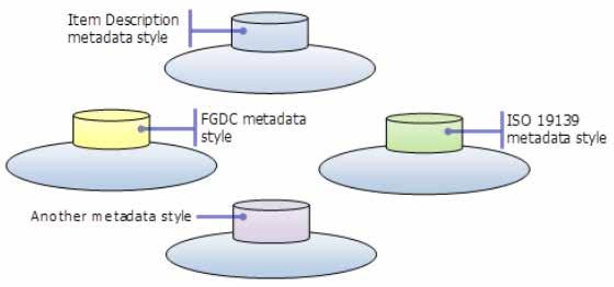
15 Set the metadata standard/style you regularly use
16 Selected metadata style All options are set appropriately for a given metadata standard or profile Controls the display, creation, editing, validation, and default export format Different styles include different pages - North American Profile style supports adding country codes

17 ArcGIS 10.1 Internal Metadata Validation Identify and fix problems as you type Page flagged for having errors Problems listed Missing required value Invalid data type Expected value described

18 ArcGIS 10.1 Internal Metadata Validation As problems are fixed, errors are automatically removed from the list at the top of the page Page has no errors


19 ArcGIS 10.1 Internal Metadata Validation Different validation rules for each style/standard ISO style FGDC CSDGM style


20 Moving to ArcGIS 10 Illustrated guide to complete FGDC metadata Step by step, fully illustrated guide ties the ArcGIS metadata editor to the FGDC Production rules and CSGDM Workbook


21 Upgrading from ArcGIS Buttons let you manage ArcGIS metadata FGDC content is read-only in the Description tab

22 Tailor ArcCatalog for your profile Metadata tool kit - Custom metadata editor containing source code for all pages - Windows Presentation Foundation (WPF) application using C# and XAML - ArcGIS Metadata documentation - XSLT style sheets - Custom style configuration files - Sample Visual Studio solution - Complete instructions


23 Metadata tool kit Profile/subset ISO standard - Modify existing pages Add community specific metadata - Add custom pages Save to custom xml
24 ArcGIS Metadata Support Comprehensive support for FGDC and ISO metadata standards Robust validation - Internal validation as metadata is produced - Tailored to specific to profiles - External validation for export xml - Official XML Schema validation Metadata Toolkit - Tailor full power of ArcCatalog to support any profile Metadata SIG meeting Friday, 10:00 11:00 AM, Room 301

25 Interoperability Enablers Standards used in creation of Geo Information products - Metadata: - ISO 19139, FGDC, - Data: - Simple Features Model, - WKT, WKB, Spatial Types, GML, netcdf, Standards used for Dissemination - File Based - Simple Features Access, - On Demand Services - OGC Web Services - WMS, WFS, WCS, CS-W, WMTS, WPS,
26 Simple Features Simple Feature specification - Common Architecture - Geometry Model - Well Known Text Representation for Geometry - Well Known Binary Representation for Geometry - Well Known Text Representation for Spatial reference Systems - - Part 2 SQL Option - Database schema to support feature tables, Geometry, and Spatial Reference - SQL Geometry Type - SQL routines for constructing / obtaining a geometry object given its WKT, WKB representations - SQL Operations on Type Geometry -
27 Simple Features Simple Feature specification defines: - Data access model - Database schema - 2D Geometry model for points, lines, polygons - Well-Known data formats for geometry and spatial reference ISO and OGC specifications for simple feature access Feature Table Feature Tables contain rows (features) sharing common properties (Feature Attributes) area1 area2 yellow green Geometry is a Feature Attribute. 12 area3 Blue Feature 13 area4 red Geometry Feature Attribute
28 GML GML or Geography Markup Language is an XML based encoding Standard for geographic information developed by the Open Geospatial Consortium (OGC). GML Profiles Point profile, Simple Features Profile - Simple Feature profile - Initially motivated to help WFS use of GML 3 - Constrains the many optional elements of GML schema - Provides 3 levels of compliancy: Level 0, 1 and 2 GML Application Schemas OSMasterMap, CityGML, WaterML, O&M, Top10NL,.

29 Interoperability Enablers Standards used in creation of Geo Information products - Data: - Simple Features Model, - WKT, WKB, Spatial Types, GML, netcdf, - Metadata: - ISO 19139, FGDC, Standards used for Dissemination - File Based - Simple Features Access, - On Demand Services - OGC Web Services - WMS, WFS, WCS, CS-W, WMTS, WPS,
30 Services Oriented Architecture (SOA) Interconnected Interoperable Integrative Dynamic Discovery Service View Service Download Service Metadata Spatial Data Loosely Coupled and Orchestrated Services
31 Types of ArcGIS Services Map View or query a 2D map on the server Geocode Perform address matching on the server Geometry Provides basic geometric operations for use by web service clients ( ex. simplify, buffer, difference, trim, ) Geoprocessing Run a geo processing tool or model on the server and get the results back Image Provide access to raster data though a Web service Feature Provide access to feature querying and editing


32 ArcGIS Server - Building open and interoperable Systems ArcGIS Desktop Google Earth ArcExplorer ArcGIS Online Imagine ENVI Gaia gvsig AutoCAD OpenLayers OGC Services GeoMedia Ionic QGIS udig ArcGIS Server MapInfo
33 ArcGIS Supporting OGC Web Services WebMap Service : Geospatial picture publishing/viewing service Web Map Tiling Specification : Provides Tiled images Web Feature Service : Geospatial feature publishing/streaming service Web Coverage Service : Imagery and gridded data publishing/processing service Keyhole Markup Language Service : Geospatial feature publishing/streaming service Web Processing Service : Geospatial Processing Service Catalog Services Web : Provides an interface for registering and discovering metadata Sensor Observation Service : Delivering Sensor observations
34 OGC Services in ArcGIS Server - Architecture Implemented as capabilities of ArcGIS Server services - Map Service - WMS, WCS, WFS, KML, WMTS (10.1) - Image Service - WMS, WCS, KML - GeoData Service - WCS, WFS, KML - Geoprocessing Service - WPS (10.1) Inherit from ArcGIS Server services - Rich features from ArcObjects (cartography, geodatabase, caching, geoprocessing etc.) - Good authoring and publishing work flow - Scalability and Durability in distributed environment - Performance - Security mechanism

35 ArcGIS Server OGC versus REST Services Difference Interfaces ArcGIS Server OGC Services OGC (ISO) Standards ArcGIS Server REST Services Geoservices REST specification Encoding style KVP, RESTful, SOAP REST Metadata encoding OWS XML Esri JSON Feature encoding GML, KML Esri JSON Feature editing Pessimistic locking No lock, last win Symbology encoding SLD Esri JSON Filter encoding OGC Filter spec Esri JSON Client applications OGC compliant clients (ArcGIS Desktop, udig, gvsig, OpenLayers, OpenScales etc.) Esri products (ArcGIS Desktop, ArcGIS JS/Flex/Silverlight API),
 publish multiple styles at server side send external styles through SLD Filter Encoding (FE) in SLD Security (inherits ArcGIS Server Security")
36 WMS WMS on MapService KML 1.0.0, 1.1.0, 1.1.1, GetCapabilities GetMap GetFeatureInfo ArcGIS Desktop client WebADF client KML on MapService KML 2.1 Add WMS on ImageService Styled Layer Descriptors (SLD) publish multiple styles at server side send external styles through SLD Filter Encoding (FE) in SLD Security (inherits ArcGIS Server Security Framework) Bug fixes KML on ImageService and GeoDataService KML through ArcGIS REST API Bug fixes WCS WCS on MapService WCS on ImageService WCS on GeoDataService 1.0.0, 1.1.0, GetCapabilities DescribeCoverage GetCoverage Add WMS on optimized map service Support SLD_BODY Support GetStyle Support GetLegendGraphic Support WMS-T (TIME) Bug fixes WMTS KML 2.2 (to OGC namespace) Support TIME in KML Bug fixes Bug fixes Updated Make WCS layer GP tool Add WCS on Optimized Map Service Ass TIME support Bug fixes Add WMTS on cached map service Bug fixes Bug fixes OGC Services Support WFS Make WCS layer GP tool ArcGIS Desktop client WFST on MapService WFST on GeoDataService GetCapabilities DescribeFeatureType GetFeature GetFeatureWithLock Transaction Data Interoperability Extension WFS to FeatureClass GP tool Add WFST (9.3 SP1) Add WFS on Optimized MapService Add WFST on non-versioned geodatabase Bug fixes WPS Performance enhancement Bug fixes Add WPS on Geoprocessing Service
37 OGC / ISO standards support ( ArcGIS 10.1) WMS + SLD + Filter Encoding Support + Time Support WFS + Transactions + Filter Encoding Support WCS +GeoTiff, NITF, HDF, JPEG, JPEG2000, PNG WMTS + REST & KVP Encoding WPS + Synchronous + Asynchronous + Data and Services as inputs CSW + OGC Core + ISO ebrim
38 ArcGIS Support for OGC Web services Server - ArcGIS Server - Esri Geoportal Server - Client - Desktop Applications - API s - Viewers -.. More Information ESRI Web Site : White papers, Product Support Matrix, OGC compliancy -
39 GIS Creating and Managing Geo Information Products - Proprietary - Open Specifications - Standards Shapefiles Open FGDB Api Dissemination of Geo Products - Proprietary - Open Specifications - Standards Geoservices REST Specification Geoservices REST Specification
40 Demonstrations
41 OGC Supported Standards Clients WMS WMS w-time KML NetCDF WFS WCS ArcGIS Desktop ArcGIS.com ArcGIS API for Flex Open Layers Exelis ENVI Quantum GIS WMTS (New 10.1) WPS (New 10.1)
 March 8 - April 12 - MeetUp at Esri (Vienna,")
 Mar 26-29 Esri")
 July 23-27 Esri")
42 Upcoming Events ( March 8 - April 12 - MeetUp at Esri (Vienna, VA) MeetUp in DC area (location TBD) Mar Esri Partner Conference (Palm Springs, CA) Mar Esri Developer Summit (Palm Springs, CA) July Esri Homeland Security Summit (San Diego, CA) July Esri International User Conference (San Diego, CA)


43 Thursday Evening Reception 6:30 9:30 pm Smithsonian Air and Space Museum Logistics: - 6:15 10:00 pm Buses transport between convention center and reception - Conference Badge needed for reception - Coat check available at entrance - Serving hot hors d oeuvres and beverages


44 Friday Closing Session and Hosted Lunch Join conference attendees for lunch and closing session 11:30 am 1:30 pm Ballrooms A-C, Third Level Closing Speaker Chris Smith, United States Department of Agriculture Wrap-up and request for feedback with Jack Dangermond of closing session...
45 Questions?
Leveraging the OGC Capabilities of ArcGIS Server
 Leveraging the OGC Capabilities of ArcGIS Server Satish Sankaran Interoperability and Standards Team Yingqi Tang Server Team Jessica Parteno Geodatabase Team ArcGIS Server is Open & Interoperable Using
Hosted by Esri Official Distributor
 Hosted by Esri Official Distributor Esri European User Conference October 15-17, 2012 Oslo, Norway Hosted by Esri Official Distributor Interoperability and Standards Support in ArcGIS 10.1 Roberto Lucchi
Metadata for Supporting Spatial Data on the Web. Marten Hogeweg & Satish Sankaran
 Metadata for Supporting Spatial Data on the Web Marten Hogeweg & Satish Sankaran Tim Berners Lee s rating system for the WWW Published Accessible Discoverable Associations Data is released Data is structured
Discovery and Access of Geospatial Resources using the Geoportal Extension. Marten Hogeweg Geoportal Extension Product Manager
 Discovery and Access of Geospatial Resources using the Geoportal Extension Marten Hogeweg Geoportal Extension Product Manager DISCOVERY AND ACCESS USING THE GEOPORTAL EXTENSION Geospatial Data Is Very
Geospatial Standards Support - An Overview. Marten Hogeweg & Satish Sankaran
 Geospatial Standards Support - An Overview Marten Hogeweg & Satish Sankaran Agenda Interoperability and Standards ArcGIS Open, Interoperable and Standards Compliant Esri Open initiatives Understanding
These modules are covered with a brief information and practical in ArcGIS Software and open source software also like QGIS, ILWIS.
 Online GIS Training and training modules covered are: 1. ArcGIS, Analysis, Fundamentals and Implementation 2. ArcGIS Web Data Sharing 3. ArcGIS for Desktop 4. ArcGIS for Server These modules are covered
SDI Standards at work
 SDI Standards at work Jan Juul Jensen Senior Technology Strategist Informi GIS Denmark Informi GIS Private held Limited Company Specialized in GIS 100+ employees HQ in Charlottenlund, Copenhagen Regional
Portals: Standards in Action
 Portals: Standards in Action David Danko ISO TC 211 Metadata Project Leader GIS Standards Consultant-ESRI. Metadata Portals Portal gateway, place of entry Producers Advertise, expose products Share information
ArcGIS for Military: Analyzing the Operational Environment. Matthew Funk Carolyn Fish
 ArcGIS for Military: Analyzing the Operational Environment Matthew Funk Carolyn Fish Geospatial Enterprise for the Military Sensors Operations Server COP Mounted Intelligence Planning Provisioning Dismounted
Key Points Sharing fosters participation and collaboration Metadata has a big role in sharing Sharing is not always easy
 Sharing Resources Geoff Mortson esri, Inc. SDI Solutions Team Key Points Sharing fosters participation and collaboration Metadata has a big role in sharing Sharing is not always easy Data Sharing is Good
ArcGIS for INSPIRE. Marten Hogeweg Satish Sankaran
 ArcGIS for INSPIRE Marten Hogeweg Satish Sankaran Outline What is ArcGIS ArcGIS for INSPIRE Web GIS Case Studies Roadmap Q&A What is INSPIRE? INSPIRE is the legal framework for a European Spatial Data
Overview of Geospatial Open Source Software which is Robust, Feature Rich and Standards Compliant
 Overview of Geospatial Open Source Software which is Robust, Feature Rich and Standards Compliant Cameron SHORTER, Australia Key words: Open Source Geospatial Foundation, OSGeo, Open Standards, Open Geospatial
A Geographer s role in a Google Maps World. Jeremy Bartley ESRI
 A Geographer s role in a Google Maps World Jeremy Bartley ESRI 1 It is a good time to be a Geographer. 2 Microsoft, Google, Yahoo, and others are pushing geographic awareness to the general public Providing
Innovation. The Push and Pull at ESRI. September Kevin Daugherty Cadastral/Land Records Industry Solutions Manager
 Innovation The Push and Pull at ESRI September 2004 Kevin Daugherty Cadastral/Land Records Industry Solutions Manager The Push and The Pull The Push is the information technology that drives research and
Cadastral Standards & Interoperability
 Cadastral Standards & Interoperability Some Considerations Black Hills Digital Mapping Association September 18, 2007 Jeanne Foust ESRI Spatial Data Infrastructure Global Manager jfoust@esri.com Why is
Why GIS & Why Internet GIS?
 Why GIS & Why Internet GIS? The Internet bandwagon Internet mapping (e.g., MapQuest) Location-based services Real-time navigation (e.g., traffic) Real-time service dispatch Business Intelligence Spatial
Spatial Data Infrastructure Concepts and Components. Douglas Nebert U.S. Federal Geographic Data Committee Secretariat
 Spatial Data Infrastructure Concepts and Components Douglas Nebert U.S. Federal Geographic Data Committee Secretariat August 2009 What is a Spatial Data Infrastructure (SDI)? The SDI provides a basis for
ArcGIS 10.1 An Overview of the System
 ArcGIS 10.1 An Overview of the System ArcGIS 10.1 An Overview of the System Damian Spangrud Director of Solutions, Esri Redlands, CA USA ArcGIS 10.1 Web Cloud Online Mobile Enterprise Desktop ArcGIS 10.1
Using OGC standards to improve the common
 Using OGC standards to improve the common operational picture Abstract A "Common Operational Picture", or a, is a single identical display of relevant operational information shared by many users. The
Implementing INSPIRE Geoportal in Turkey
 Implementing INSPIRE Geoportal in Turkey Gencay SERTER City and Regional Planner 1 Presentation Plan Introduction INSPIRE and Turkey Importance of al Spatial Planning Portal Logical&Legal Hierarchy GeoPortal
Data Aggregation with InfraWorks and ArcGIS for Visualization, Analysis, and Planning
 Data Aggregation with InfraWorks and ArcGIS for Visualization, Analysis, and Planning Stephen Brockwell President, Brockwell IT Consulting, Inc. Join the conversation #AU2017 KEYWORD Class Summary Silos
ArcGIS for INSPIRE. Marten Hogeweg
 ArcGIS for INSPIRE Marten Hogeweg Please Take Our Survey on the App Download the Esri Events app and find your event Select the session you attended Scroll down to find the feedback section Complete answers
ESRI Survey Summit August Clint Brown Director of ESRI Software Products
 ESRI Survey Summit August 2006 Clint Brown Director of ESRI Software Products Cadastral Fabric How does Cadastral fit with Survey? Surveyors process raw field observations Survey measurements define high-order
Enabling ENVI. ArcGIS for Server
 Enabling ENVI throughh ArcGIS for Server 1 Imagery: A Unique and Valuable Source of Data Imagery is not just a base map, but a layer of rich information that can address problems faced by GIS users. >
Introduction to ArcGIS Server - Creating and Using GIS Services. Mark Ho Instructor Washington, DC
 Introduction to ArcGIS Server - Creating and Using GIS Services Mark Ho Instructor Washington, DC Technical Workshop Road Map Product overview Building server applications GIS services Developer Help resources
WEB MAP SERVICE (WMS) FOR GEOLOGICAL DATA GEORGE TUDOR
 FOR GEOLOGICAL DATA GEORGE TUDOR") WEB MAP SERVICE (WMS) FOR GEOLOGICAL DATA GEORGE TUDOR WEB MAP SERVICE (WMS) - GENERALITIES Projects with data from different sources Geological data are in different GIS software format Large amount of
WEB MAP SERVICE (WMS) FOR GEOLOGICAL DATA GEORGE TUDOR WEB MAP SERVICE (WMS) - GENERALITIES Projects with data from different sources Geological data are in different GIS software format Large amount of
Experiences and Directions in National Portals"
 FIG Seminar on e-land Administration Innsbruck/Austria 2-4 June 2004 "ESRI's Experiences and Directions in National Portals" Kevin Daugherty Cadastral/Land Records Manager ESRI Topic Points Technology
Esri UC2013. Technical Workshop.
 Esri International User Conference San Diego, California Technical Workshops July 9, 2013 CAD: Introduction to using CAD Data in ArcGIS Jeff Reinhart & Phil Sanchez Agenda Overview of ArcGIS CAD Support
Geospatial Products V8i (SELECTseries 1)
") Geospatial Products V8i (SELECTseries 1) Keith Raymond Product Manager Geospatial Desktop Products Presentation Overview What are the various products? Why would you need them? Demonstrations 2 WWW.BENTLEY.COM
Geospatial Products V8i (SELECTseries 1) Keith Raymond Product Manager Geospatial Desktop Products Presentation Overview What are the various products? Why would you need them? Demonstrations 2 WWW.BENTLEY.COM
ELF products in the ArcGIS platform
 ELF products in the ArcGIS platform Presentation to: Author: Date: NMO Summit 2016, Dublin, Ireland Clemens Portele 18 May 2016 The Building Blocks 18 May, 2016 More ELF users through affiliated platforms
ArcGIS. for Server. Understanding our World
 ArcGIS for Server Understanding our World ArcGIS for Server Create, Distribute, and Manage GIS Services You can use ArcGIS for Server to create services from your mapping and geographic information system
Introduction to ArcGIS Server Development
 Introduction to ArcGIS Server Development Kevin Deege,, Rob Burke, Kelly Hutchins, and Sathya Prasad ESRI Developer Summit 2008 1 Schedule Introduction to ArcGIS Server Rob and Kevin Questions Break 2:15
ISO Series Standards in a Model Driven Architecture for Landmanagement. Jürgen Ebbinghaus, AED-SICAD
 ISO 19100 Series Standards in a Model Driven Architecture for Landmanagement Jürgen Ebbinghaus, AED-SICAD 29.10.2003 The Company 100% SIEMENS PTD SIEMENS Business Services Shareholder & Strategic Business
A Vision for ArcGIS Applying Geography Everywhere
 A Vision for ArcGIS Applying Geography Everywhere WELCOME PURPOSE A Network of GIS Professionals Are Awakening the World to the Power of Web GIS You Your WORK Making a Difference Your Work Open Maps and
OGC Standards Update 29 November 2018 Orlando
 OGC Standards Update 29 November 2018 Orlando Mark Reichardt mreichardt@opengeospatial.org +1 301 840-1361 OGC S INTEREST It s simple You have this or this and you need to make this... or this Courtesy
Paper UC1351. Conference: User Conference Date: 08/10/2006 Time: 8:30am-9:45am Room: Room 23-B (SDCC)
") Conference: User Conference Date: 08/10/2006 Time: 8:30am-9:45am Room: Room 23-B (SDCC) Title of Paper: Increasing the Use of GIS in the Federal Government Author Name: Miss Abstract This presentation
Conference: User Conference Date: 08/10/2006 Time: 8:30am-9:45am Room: Room 23-B (SDCC) Title of Paper: Increasing the Use of GIS in the Federal Government Author Name: Miss Abstract This presentation
Getting Started with Community Maps
 Esri International User Conference San Diego, California Technical Workshops July 24, 2012 Getting Started with Community Maps Shane Matthews and Tamara Yoder Topics for this Session ArcGIS is a complete
Spatial data interoperability and INSPIRE compliance the platform approach BAGIS
 Spatial data interoperability and INSPIRE compliance the platform approach BAGIS BAGIS Voluntary, independent, public, non-profit organization; Organization with main mission to promote the growth of the
CARTOGRAPHIC WEB SERVICES AND CARTOGRAPHIC RULES A NEW APPROACH FOR WEB CARTOGRAPHY
 CARTOGRAPHIC WEB SERVICES AND CARTOGRAPHIC RULES A NEW APPROACH FOR WEB CARTOGRAPHY 1. Introduction Ionut Iosifescu, Marco Hugentobler, Lorenz Hurni ETH Zurich, Institute of Cartography Wolfgang-Pauli-Str.
Exelis and Esri Technologies for Defense and National Security. Cherie Muleh
 Exelis and Esri Technologies for Defense and National Security Cherie Muleh Cherie.Muleh@exelisinc.com ENVI IMAGERY AND DATA BECOME KNOWLEDGE > Add information from imagery to your GIS > Automated workflows
This Week is All About GIS, Geography and Sharing Our Knowledge
 Stockholm 2007 1 This Week is All About GIS, Geography and Sharing Our Knowledge Technology Methods Organization Data Processes Standards Projects Visualization And About You Applications Mapping Data
Geo-Enabling Digital India. 15 th Esri India User Conference GIS and Smart Cities
 15 th Esri India User Conference 2014 GIS and Smart Cities 15 th Esri India User Conference 2014 GIS and Smart Cities Agendra Kumar President, Esri India Our World Is Facing Serious Challenges Our World
OGC GEOPACKAGE AND HOW OPEN SOURCE IS CHANGING THE WAY GOVERNMENTS THINK ABOUT STANDARDS. Nathan Frantz Geospatial Research Lab
 OGC GEOPACKAGE AND HOW OPEN SOURCE IS CHANGING THE WAY GOVERNMENTS THINK ABOUT STANDARDS Nathan Frantz Geospatial Research Lab Dr. Ben Tuttle National Geospatial-Intelligence Agency FOSS4G 2015 Geospatial
Introduction to geoprocessing services using SEXTANTE. Víctor Olaya SEXTANTE Geospatial Services
 Introduction to geoprocessing services using SEXTANTE. Víctor Olaya SEXTANTE Geospatial Services Overview Quick introduction to SEXTANTE Client/Server fundamentals Standards for web-based geoservices SEXTANTE
Technical Specifications. Form of the standard
 Used by popular acceptance Voluntary Implementation Mandatory Legally enforced Technical Specifications Conventions Guidelines Form of the standard Restrictive Information System Structures Contents Values
ESRI Quality Solution
 ESRI Quality Solution Paul Hardy Business Development Consultant (NMCAs) ESRI Europe phardy@esri.com ESRI Quality Solution Geodatabase Integrity Schema constraints (Attribute Domains etc) Rich data types
Managing Imagery and Raster Data Using Mosaic Datasets
 Esri International User Conference San Diego, California Technical Workshops July 25, 2012 Managing Imagery and Raster Data Using Mosaic Datasets Hong Xu, Prashant Mangtani Presentation Overview Introduction
Geodatabase An Introduction
 2013 Esri International User Conference July 8 12, 2013 San Diego, California Technical Workshop Geodatabase An Introduction David Crawford and Jonathan Murphy Session Path The Geodatabase What is it?
You are Building Your Organization s Geographic Knowledge
 You are Building Your Organization s Geographic Knowledge And Increasingly Making it Available Sharing Data Publishing Maps and Geo-Apps Developing Collaborative Approaches Citizens Knowledge Workers Analysts
Bureau of Meteorology use of open spatial standards
 Bureau of Meteorology use of open spatial standards Robert Wilson Bruce Bannerman ISO TC211 8 Dec 2010 V0.4 061208 Overview Current - Bob Bureau Web Services Enterprise Architecture Bruce Climate and Water
October 2011 ArcGIS 10 for Server Functionality Matrix
 October 2011 ArcGIS 10 for Server Functionality Matrix Esri, 380 New York St., Redlands, CA 92373-8100 USA TEL 909-793-2853 FAX 909-793-5953 E-MAIL info@esri.com WEB www.esri.com Copyright 2011 Esri All
How does ArcGIS Server integrate into an Enterprise Environment? Willy Lynch Mining Industry Specialist ESRI, Denver, Colorado USA
 How does ArcGIS Server integrate into an Enterprise Environment? Willy Lynch Mining Industry Specialist ESRI, Denver, Colorado USA wlynch@esri.com ArcGIS Server Technology Transfer 1 Agenda Who is ESRI?
Esri Overview for Mentor Protégé Program:
 Agenda Passionate About Helping You Succeed Esri Overview for Mentor Protégé Program: Northrop Grumman CSSS Jeff Dawley 3 September 2010 Esri Overview ArcGIS as a System ArcGIS 10 - Map Production - Mobile
Working with OGC WCS Services - WCS in ArcGIS. Zikang Zhou
 Working with OGC WCS Services - WCS in ArcGIS Zikang Zhou zzhou@esri.com OGC WCS introduction The Open Geospatial Consortium, Inc. (OGC) Web Coverage Service (WCS) provides an open specification for sharing
The PREVIEW Global Risk Data Platform: a geoportal to serve and share global data on risk to natural hazards
 The PREVIEW Global Risk Data Platform: a geoportal to serve and share global data on risk to natural hazards Gregory Giuliani (UNEP/GRID-Geneva & University of Geneva/enviroSPACE ) http://www.grid.unep.ch
Working with OGC WCS. Zikang Zhou
 Working with OGC WCS Zikang Zhou zzhou@esri.com Working with OGC WCS Introduction The Open Geospatial Consortium, Inc. (OGC) Web Coverage Service (WCS) provides an open specification for sharing coverages
Geodatabase Essentials Part One - Intro to the Geodatabase. Jonathan Murphy Colin Zwicker
 Geodatabase Essentials Part One - Intro to the Geodatabase Jonathan Murphy Colin Zwicker Session Path The Geodatabase - What is it? - Why use it? - What types are there? Inside the Geodatabase Advanced
The Geo Web: Enabling GIS on the Internet IT4GIS Keith T. Weber, GISP GIS Director ISU GIS Training and Research Center.
 The Geo Web: Enabling GIS on the Internet IT4GIS Keith T. Weber, GISP GIS Director ISU GIS Training and Research Center In the Beginning GIS was independent The GIS analyst or manager was typically a oneperson
ArcGIS for INSPIRE. Paul Hardy. ArcGIS. ArcGIS for INSPIRE Enables Esri ArcGIS users to implement and comply with INSPIRE. INSPIRE Data Themes
 Enables Esri ArcGIS users to implement and comply with INSPIRE Paul Hardy phardy@esri.com EuroGeographics INSPIRE KEN (Schema Transformation) 8/9 October 2013, Marne la Vallée INSPIRE Data Themes Annex
Some of the underlying goals of the GIS Library are to:
 1 2001 It was born out of the recognition that several of the regions prominent resource management agencies have similar, if not shared, requirements for GIS data. Some of the underlying goals of the
Esri WebGIS Highlights of What s New, and the Road Ahead
 West Virginia GIS Conference WVU, Morgantown, WV Esri WebGIS Highlights of What s New, and the Road Ahead Mark Scott, Solutions Engineer, Esri Local Government Team May 5 th, 2016 West Virginia GIS Conference
GEOSPATIAL WEB SERVICE INTEGRATION AND MASHUPS FOR WATER RESOURCE APPLICATIONS
 GEOSPATIAL WEB SERVICE INTEGRATION AND MASHUPS FOR WATER RESOURCE APPLICATIONS C. Granell a, *, L. Díaz a, M. Gould a a Center for Interactive Visualization, Department of Information Systems, Universitat
GIS GIS.
 GIS 388 Vol., No.3, Autumn 2009 99-4 GIS Iranian Remote Sensing & GIS 2 * (GIS). GIS.2 389/5/6 : 389/2/6 :........ : 8878622 : GIS ( ) : * Email: PouriaAmirian@gmail.com ... (AQI) 2.(Cheng et al., 2007)..
INTRODUCTION TO ARCGIS Version 10.*
 Week 3 INTRODUCTION TO ARCGIS Version 10.* topics of the week Overview of ArcGIS Using ArcCatalog Overview of ArcGIS Desktop ArcGIS Overview Scalable desktop applications ArcView ArcEditor ArcInfo ArcGIS
The File Geodatabase API. Craig Gillgrass Lance Shipman
 The File Geodatabase API Craig Gillgrass Lance Shipman Schedule Cell phones and pagers Please complete the session survey we take your feedback very seriously! Overview File Geodatabase API - Introduction
Safe to Save? Archive Options for Geodatabases. Jeff Essic North Carolina State University Libraries
 Safe to Save? Archive Options for Geodatabases Jeff Essic North Carolina State University Libraries 2011 ESRI International Users Conference July 13, 2011 GeoMAPP Geospatial Multistate Archive and Preservation
Using CAD data in ArcGIS
 Using CAD data in ArcGIS Phil Sanchez and Jeff Reinhart Esri UC 2014 Technical Workshop Agenda Overview of ArcGIS CAD Support Using CAD Datasets in ArcMap Georeferencing CAD data for ArcGIS Loading CAD
Features and Benefits
 Autodesk LandXplorer Features and Benefits Use the Autodesk LandXplorer software family to help improve decision making, lower costs, view and share changes, and avoid the expense of creating physical
UNIT 4: USING ArcGIS. Instructor: Emmanuel K. Appiah-Adjei (PhD) Department of Geological Engineering KNUST, Kumasi
 Department of Geological Engineering KNUST, Kumasi") UNIT 4: USING ArcGIS Instructor: Emmanuel K. Appiah-Adjei (PhD) Department of Geological Engineering KNUST, Kumasi Getting to Know ArcGIS ArcGIS is an integrated collection of GIS software products ArcGIS
UNIT 4: USING ArcGIS Instructor: Emmanuel K. Appiah-Adjei (PhD) Department of Geological Engineering KNUST, Kumasi Getting to Know ArcGIS ArcGIS is an integrated collection of GIS software products ArcGIS
A Spatial Data Infrastructure for Landslides and Floods in Italy
 V Convegno Nazionale del Gruppo GIT Grottaminarda 14 16 giugno 2010 A Spatial Data Infrastructure for Landslides and Floods in Italy Ivan Marchesini, Vinicio Balducci, Gabriele Tonelli, Mauro Rossi, Fausto
Reprint of article that appeared in Hydro INTERNATIONAL November 2006 Volume 10 Issue 9
 Reprint of article that appeared in Hydro INTERNATIONAL November 2006 Volume 10 Issue 9 While Google Earth is the best known 3D web-mapping viewer currently in the public domain, there are alternative
Environmental Systems Research Institute, Inc.
 Environmental Systems Research Institute, Inc. 380 New York Street Redlands, CA 92373-8100 Telephone: + (909) 793-2853 Facsimile: + (909) 307-3034 Supporting GEOSS Common Architecture and Societal Benefit
OSGIS Platform. Storing and distributing PostGIS, Deegree, UMN Map Server Desktop visualization JUMP, QGIS, Thuban, udig, gvsig
 GIS groups of tasks Geodata collecting, updating Geodata storing and distributing Geodata analysis Geodata visualization: Desktop, Internet, Printing Geodata describing: metadata management Geodata converting:
Climate Data for Non-experts: Standards-based Interoperability
 Climate Data for Non-experts: Standards-based Interoperability Ben Domenico Unidata Program Center University Corporation for Atmospheric Research April 2010 Working Together on A Mosaic for Atmospheric
Administering your Enterprise Geodatabase using Python. Jill Penney
 Administering your Enterprise Geodatabase using Python Jill Penney Assumptions Basic knowledge of python Basic knowledge enterprise geodatabases and workflows You want code Please turn off or silence cell
ArcGIS is Advancing. Both Contributing and Integrating many new Innovations. IoT. Smart Mapping. Smart Devices Advanced Analytics
 ArcGIS is Advancing IoT Smart Devices Advanced Analytics Smart Mapping Real-Time Faster Computing Web Services Crowdsourcing Sensor Networks Both Contributing and Integrating many new Innovations ArcGIS
ArcGIS Runtime: Migrating from ArcGIS Engine. Rex Hansen
 ArcGIS Runtime: Migrating from ArcGIS Engine Rex Hansen Thank You to Our Sponsors Migrating from ArcGIS Engine to ArcGIS Runtime ArcGIS Runtime API: new and evolved workflows on all platforms Windows Linux
gvsig a real tool for GIS technicians
 gvsig a real tool for GIS technicians Jorge Gaspar Sanz Salinas jsanz@prodevelop.es International Geodetic Students Meeting 05/05/08 Valencia Agenda of the project OK, but what can gvsig do for me now?
Questions and Answers
 AUTODESK LANDXPLORER SOFTWARE FAMILY Questions and Answers The Autodesk LandXplorer 3D city model software family can help you create, analyze, and visualize digital city models. Contents Autodesk Landxplorer
Communicating Geospatial Information across Communities and Technologies. Presentation to IHO Marine Spatial Data Infrastructure Forum
 Communicating Geospatial Information across Communities and Technologies Presentation to IHO Marine Spatial Data Infrastructure Forum George Percivall OGC Chief Engineer 4 February 2014 OGC Copyright 2014
Pushing the Standards Edge: Collaborative Testbeds to Accelerate Standards Development and Implementation
 Pushing the Standards Edge: Collaborative Testbeds to Accelerate Standards Development and Implementation Mark E. Reichardt President mreichardt@opengeospatial.org 31 October 2006 2006 Open Geospatial
THE WASHINGTON COASTAL ATLAS
 THE ICAN COASTAL ATLAS MEDIATOR PROTOTYPE AND CONNECTING THE WASHINGTON COASTAL ATLAS Liz O Dea 1, Yassine Lassoued 2, Tanya Haddad 3, Declan Dunne 2 1 GIS Services Unit, WA State Dept. of Ecology 2 Coastal
YYT-C3002 Application Programming in Engineering GIS I. Anas Altartouri Otaniemi
 YYT-C3002 Application Programming in Engineering GIS I Otaniemi Overview: GIS lectures & exercise We will deal with GIS application development in two lectures. Because of the versatility of GIS data models
Geodatabase An Introduction
 Federal GIS Conference 2014 February 10 11, 2014 Washington DC Geodatabase An Introduction Ralph Denkenberger esri Session Path The Geodatabase - What is it? - Why use it? - What types are there? Inside
What s New. August 2013
 What s New. August 2013 Tom Schwartzman Esri tschwartzman@esri.com Esri UC2013. Technical Workshop. What is new in ArcGIS 10.2 for Server ArcGIS 10.2 for Desktop Major Themes Why should I use ArcGIS 10.2
GENERALIZATION IN THE NEW GENERATION OF GIS. Dan Lee ESRI, Inc. 380 New York Street Redlands, CA USA Fax:
 GENERALIZATION IN THE NEW GENERATION OF GIS Dan Lee ESRI, Inc. 380 New York Street Redlands, CA 92373 USA dlee@esri.com Fax: 909-793-5953 Abstract In the research and development of automated map generalization,
ArcGIS Runtime: Migrating Your Apps from ArcGIS Engine. Eric Bader Lucas Danzinger Mike Branscomb
 ArcGIS Runtime: Migrating Your Apps from ArcGIS Engine Eric Bader Lucas Danzinger Mike Branscomb Migrating to ArcGIS Runtime ArcGIS Engine ArcGIS Runtime AppStudio for ArcGIS Apps: Collector, Workforce,
Using the File Geodatabase API. Lance Shipman David Sousa
 Using the File Geodatabase API Lance Shipman David Sousa Overview File Geodatabase API - Introduction - Supported Tasks - API Overview - What s not supported - Updates - Demo File Geodatabase API Provide
EEOS 381 -Spatial Databases and GIS Applications
 EEOS 381 -Spatial Databases and GIS Applications Lecture 5 Geodatabases What is a Geodatabase? Geographic Database ESRI-coined term A standard RDBMS that stores and manages geographic data A modern object-relational
ArcGIS Enterprise: What s New. Philip Heede Shannon Kalisky Melanie Summers Shreyas Shinde
 ArcGIS Enterprise: What s New Philip Heede Shannon Kalisky Melanie Summers Shreyas Shinde ArcGIS Enterprise is the new name for ArcGIS for Server ArcGIS Enterprise Software Components ArcGIS Server Portal
ArcGIS Pro Q&A Session. NWGIS Conference, October 11, 2017 With John Sharrard, Esri GIS Solutions Engineer
 ArcGIS Pro Q&A Session NWGIS Conference, October 11, 2017 With John Sharrard, Esri GIS Solutions Engineer jsharrard@esri.com ArcGIS Desktop The applications ArcGIS Pro ArcMap ArcCatalog ArcScene ArcGlobe
Imagery and the Location-enabled Platform in State and Local Government
 Imagery and the Location-enabled Platform in State and Local Government Fred Limp, Director, CAST Jim Farley, Vice President, Leica Geosystems Oracle Spatial Users Group Denver, March 10, 2005 TM TM Discussion
Bentley Geospatial update
 Bentley Geospatial update Tallinna, 01.11.2007 Timo Tuukkanen, Bentley Systems Issues today Bentley Map available now detailed introduction to Bentley Map Bentley Geo Web Publisher Bentley Web GIS update,
Enabling the Image Analyst (IA) to use the geodatabase
 to use the geodatabase") Enabling the Image Analyst (IA) to use the geodatabase Rick Racine, BAE Systems, Reston, VA Stewart Walker, BAE Systems, San Diego, CA 2008 ESRI Federal User Conference, Washington, D.C., 21 February 2610020508
Enabling the Image Analyst (IA) to use the geodatabase Rick Racine, BAE Systems, Reston, VA Stewart Walker, BAE Systems, San Diego, CA 2008 ESRI Federal User Conference, Washington, D.C., 21 February 2610020508
Federal GIS Conference February 10 11, 2014 Washington DC. Standards in action. David Danko, Esri Marten Hogeweg, Esri
 Federal GIS Conference 2014 February 10 11, 2014 Washington DC Standards in action David Danko, Esri Marten Hogeweg, Esri ESRI learns about and supports standards through active participation: Organizations
Geoprovisioning delivers geodata and its analysis for specific areas on request.
 DRAFT 27 February 2009 Geoprovisioning Geoprovisioning delivers geodata and its analysis for specific areas on request. What are the components of a geoprovisioning service? The sample web site geoprovisioning.com
European Location Framework data in the ArcGIS platform
 European Location Framework data in the ArcGIS platform Presentation to: Author: Date: INSPIRE Conference 2016 Clemens Portele 26 September 2016 Why ELF? Global (e.g. UN GGIM) Regional Europe (INSPIRE
A Model of GIS Interoperability Based on JavaRMI
 A Model of GIS Interoperability Based on Java Gao Gang-yi 1 Chen Hai-bo 2 1 Zhejiang University of Finance & Economics, Hangzhou 310018, China 2 College of Computer Science and Technology, Zhejiang UniversityHangzhou
Bentley Map Advancing GIS for the World s Infrastructure
 Bentley Map Advancing GIS for the World s Infrastructure Presentation Overview Why would you need Bentley Map? What is Bentley Map? Where is Bentley Map Used? Why would you need Bentley Map? Because your
What is GIS and How Can It Help Me?
 esri European User Conference Madrid 2011 What is GIS and How Can It Help Me? Jaime Nieves Ignacio Vázquez esri spain «Knowing where things are, and why, is essential to rational decision making.» Jack