Bentley Geospatial update
|
|
|
- Jonah French
- 5 years ago
- Views:
Transcription

1 Bentley Geospatial update Tallinna, Timo Tuukkanen, Bentley Systems
2 Issues today Bentley Map available now detailed introduction to Bentley Map Bentley Geo Web Publisher Bentley Web GIS update, what is in the new version Bentley Geospatial Management spatially relating all you content in ProjectWise
3 Bentley Map Advanced GIS for the World s Infrastructure Timo Tuukkanen, Bentley Systems

4 Presentation Overview What is Bentley Map Where is Bentley Map Used? Features What s New in Bentley Map? Benefits Value Proposition
5 What is Bentley Map? Comprehensive GIS for mapping and infrastructure Efficient data compilation and editing Design, build and publish accurate maps Enforce business and topological rules Administration tools provided to define rules for intelligent features All the power of MicroStation V8 XM Edition Platform for building intelligent facility models Brings CAD accuracy, ease-of-use and efficiency to GIS Fully compatible with Bentley s AEC Applications
6 Infrastructure! FAA Caltrans Sandia Nacap Telecom BV Ameren
7 Advancing GIS for Infrastructure Diversity Federated Information Management via the Geospatial Server Modeling Reality - 3D Model the real world Engineering users Unified environment for planning, analysis, design, management Openness Environment based on Oracle 10g Spatial and OGC Standards Multi-disciplinary projects Use of best of breed tools with collaboration Workflow Focus on the whole enterprise
8 GIS for Infrastructure!


9 Where is Bentley Map Used? Organizations: Governments Mapping Agencies Mapping Service Firms Utilities Communications Providers Departments of Transportation Public Works Oil and Gas Companies Consulting Engineers Users: GIS professionals Mapping technicians Cartographers Engineers Designers
10 Advancing GIS for Infrastructure A full-featured GIS for the world s infrastructure Bentley Geospatial Web Publishing Ideal standalone for mapping applications A robust platform for Bentley s infrastructure applications Bentley Geospatial Industry Applications Bentley Geospatial Server The desktop foundation in a flexible enterprise architecture Bentley Bentley Geospatial Desktop Uniquely allows a choice Desktop of persistent data stores Unites the best of GIS with the power of MicroStation Bentley Geospatial Mobile Applications Enterprise Integration

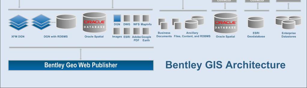
11 A Highly Flexible Architecture
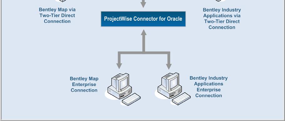
12 Your Choice of Data Stores A two-tier connection to Oracle Spatial A three-tier connection to Oracle Spatial A three-tier connection to ArcGIS Self-contained XFM DGN files Any RDBMS/DGN supported by MicroStation


13 Top Features All the power of MicroStation Map Manager XML Feature Modeling Geospatial Administrator Oracle Spatial editing Topology model and maintenance Spatial analysis and presentation Map generation and print preparation Map projection and coordinate conversion Data cleanup tools Interoperability GIS Development Platform


14 Top Features All the power of MicroStation Map Manager XML Feature Modeling Geospatial Administrator Oracle Spatial editing Topology model and maintenance Spatial analysis and presentation Map generation and print preparation Map projection and coordinate conversion Data cleanup tools Interoperability GIS Development Platform
15 All the Power of MicroStation What does it mean? Smart, quick drawing and editing of GIS features in a MicroStation environment Raster management Dimensioning AccuSnap, AccuDraw Display priority, transparency Photorealistic visualization and animation Full 3D modeling Superior MicroStation printing and publishing Workspace management for large projects

16 Top Features All the power of MicroStation Map Manager XML Feature Modeling Geospatial Administrator Oracle Spatial editing Topology model and maintenance Spatial analysis and presentation Map generation and print preparation Map projection and coordinate conversion Data cleanup tools Interoperability GIS Development Platform

17 Map Manager An easy-to-learn interface into your spatial data Intuitive, easy-to-use, persisted map definition Allows for multiple map definitions Override symbology MicroStation transparency Scale based visibility Drag and drop layers to control display order Facilitator for: Seamless mapping Integration of many spatial data formats Thematic presentation and more!


18 Top Features All the power of MicroStation Map Manager XML Feature Modeling Geospatial Administrator Oracle Spatial editing Topology model and maintenance Spatial analysis and presentation Map generation and print preparation Map projection and coordinate conversion Data cleanup tools Interoperability GIS Development Platform
19 XML Feature Modeling (XFM) XML Metadata Driven GIS Features Properties Domain lists, default values Property based symbology Property based annotation Relationships Placement and editing rules Operations and methods Other behaviors Message propagation rules User interface Extensible Enforces user standards Easy to implement without programming GeoSpatial Administrator XFM Schema Bentley Map geographic objects
20


21 Top Features All the power of MicroStation Map Manager XML Feature Modeling Geospatial Administrator Oracle Spatial editing Topology model and maintenance Spatial analysis and presentation Map generation and print preparation Map projection and coordinate conversion Data cleanup tools Interoperability GIS Development Platform
22 Geospatial Administrator How does it work? Manages the XFM framework through one interface Runs outside MicroStation Defines and maintains XFM project files Schema contains comprehensive definition of geographic objects (features) Defines coordinate system and projection information User interface definition dynamically loaded at run-time Inclusion of custom made VBA or MDL routines User specific definition of features, operations, methods using workspaces Automatically generates MicroStation workspaces and Map metadata files


23 Top Features All the power of MicroStation Map Manager XML Feature Modeling Geospatial Administrator Oracle Spatial editing Topology model and maintenance Spatial analysis and presentation Map generation and print preparation Map projection and coordinate conversion Data cleanup tools Interoperability GIS Development Platform
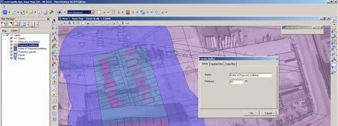
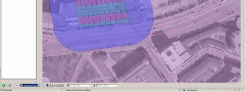
24 Oracle Spatial Editing Fully Oracle Spatial Compliant: Two-tier connection Directly query, capture, edit and post Oracle Spatial data Supports multi-user access via feature locking Three-tier connection Available via the Oracle Connector Supports multi-user access via Oracle standard versioning Adheres to native Oracle Spatial feature and topology models Maintains defined topological relationships Provides application specific editing tools for accurate feature placement and editing Includes bulk Oracle Spatial Load tool
25
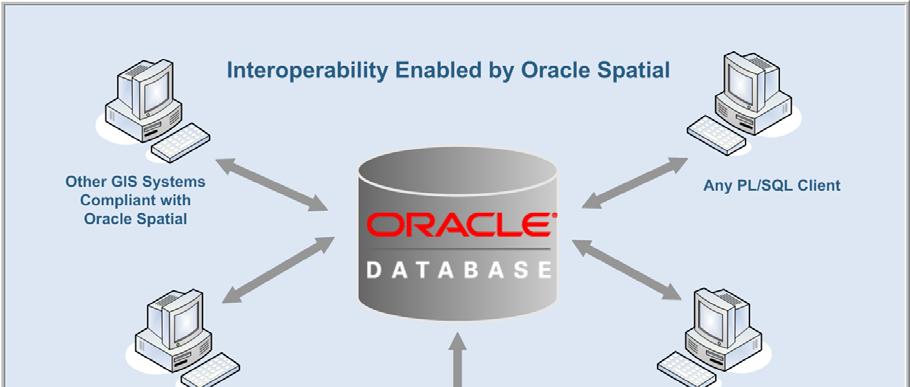
26 Interoperability with Oracle Spatial


27 Top Features All the power of MicroStation Map Manager XML Feature Modeling Geospatial Administrator Oracle Spatial editing Topology model and maintenance Spatial analysis and presentation Map generation and print preparation Map projection and coordinate conversion Data cleanup tools Interoperability GIS Development Platform
 are store in the DGN Each primitive can be associated with one or more features Both modes are supported with or without Oracle Shared editing is easier Analysis uses high")
28 Topology Model Based on the Oracle 10g topology model Two Topology modes: Session topology, built on-the-fly as needed Persistent topology, topological primitives are created only once Primitives (nodes, edges, faces) are store in the DGN Each primitive can be associated with one or more features Both modes are supported with or without Oracle Shared editing is easier Analysis uses high performance topological algorithms Features involved in topology and split/merge rules are defined in the Geospatial Administrator

29 Topology Maintenance Place features like any other XFM features Topology graph is maintained while editing Use shared editing commands to move common primitives, e.g. moving a lot corner moves all the parcels with it Split/Merge polygon command Line Cleaning tools Find dangles, gaps, duplicates From spaghetti Line Work» Shapefile» DGN» DWG» Oracle Geometry» other


30 Top Features All the power of MicroStation Map Manager XML Feature Modeling Geospatial Administrator Oracle Spatial editing Topology model and maintenance Spatial analysis and presentation Map generation and print preparation Map projection and coordinate conversion Data cleanup tools Interoperability GIS Development Platform


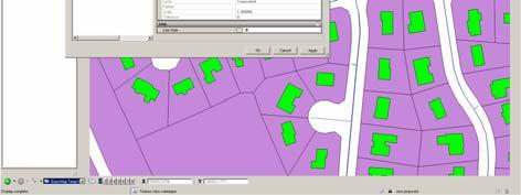
31 Spatial Analysis and Presentation Spatial Analysis Create buffers around selected features Spatial Query Overlay feature classes Results symbolization and reporting Maintain overlays in project file or export to supported formats Thematic Display Ramp Ranges Unique Value Fully configurable symbology Auto generated legends Thematic definitions persisted


32 Top Features All the power of MicroStation Map Manager XML Feature Modeling Geospatial Administrator Oracle Spatial editing Topology model and maintenance Spatial analysis and presentation Map generation and print preparation Map projection and coordinate conversion Data cleanup tools Interoperability GIS Development Platform

 Automatically")

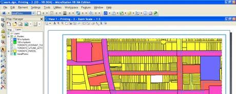
33 Map Generation and Print Preparation Grid and graticule generation Marginalia Legends North arrow Scalebar Neatlines Notifications Logos Interactively place multi-page borders Border libraries Size scale dependent Graphical placement (move, rotate, scale) Automatically place metadata in border Paper-space sheet models Plot high fidelity output through MicroStation Publish to intelligent PDF 3D PDF Bookmarks Web links


34 Top Features All the power of MicroStation Map Manager XML Feature Modeling Geospatial Administrator Oracle Spatial editing Topology model and maintenance Spatial analysis and presentation Map generation and print preparation Map projection and coordinate conversion Data cleanup tools Interoperability GIS Development Platform
35 Map Projections and Coordinate Conversion projections including user defined Store coordinate systems information with mapping and engineering data for portability Perform on-the-fly transformation Oracle Spatial information Referenced information Integrate source data in multiple projections Bulk transform spatial data between projection systems Use Geospatial Administrator to define and look up

36 Top Features All the power of MicroStation Map Manager XML Feature Modeling Geospatial Administrator Oracle Spatial editing Topology model and maintenance Spatial analysis and presentation Map generation and print preparation Map projection and coordinate conversion Data cleanup tools Interoperability GIS Development Platform
37 Data Cleanup and Integrity Tools Solve integrity problems with imported or legacy data Interactively cleanup data to establish spatial and topological integrity Find and repair dangles, gaps, slivers, overshoots, join and segment lines, reduce points Use handy editing tools to resolve data problems Use warping tools to fit data to existing control Easily adopt imported or legacy data through Dynamic Feature Scoring (DFS) Existing features (MicroStation, GeoGraphics, other) are recognized and operated on consistently via DFS rules Editing or reset of the feature causes PBS and PBA rules to be run Attributes can be easily added by editing


38 Top Features All the power of MicroStation Map Manager XML Feature Modeling Geospatial Administrator Oracle Spatial editing Topology model and maintenance Spatial analysis and presentation Map generation and print preparation Map projection and coordinate conversion Data cleanup tools Interoperability GIS Development Platform
39 Interoperability Direct reference geospatial formats MapInfo (TAB, MID/MIF), Shapefiles, Oracle Spatial Select files to reference as you would any DGN Files are referenced and transformed according to defined projection Work with the native format - identify, overlay, and more No special licensing required Use Map Manager to determine display characteristics! Import/Export via an easy-to-use interface designed for large jobs Enables direct editing in Bentley Map MapInfo (TAB, MID/MIF), Shapefiles, Oracle Spatial Customize layer symbology, properties, display order, and selected information Use any Bentley Map functionality on imported features Settings can be saved in import files which can be opened or referenced directly

40 Top Features All the power of MicroStation Map Manager XML Feature Modeling Geospatial Administrator Oracle Spatial editing Topology model and maintenance Spatial analysis and presentation Map generation and print preparation Map projection and coordinate conversion Data cleanup tools Interoperability GIS Development Platform
41 GIS Development Platform Subject Matter Experts can customize Bentley Map facilitated by the Geospatial Administrator Property Based Symbology Property Based Annotation Criteria Methods Operations Dialogs Tool frames and tool boxes Prompts Developers can further customize by extending the capabilities of Geospatial Administrator and the Standard Placement Library via: C expressions XSLT VBScript VBA MDL.NET API
42 Is Bentley Map Right for You? Yes! Especially if you are: A MicroStation or AutoCAD user who wants intelligent GIS features and GIS functionality A GIS user who wants an open, extensible GIS environment that includes all the capabilities of MicroStation A MicroStation GeoGraphics user who wants a more robust, flexible GIS environment based on V8 XM Edition Committed to Oracle Spatial as an enterprise standard An infrastructure professional who wants a single environment for all aspects of your work An AEC application user who wants wants to add geospatial context and GIS capabilities to his current environment
43 What can Bentley Map do for You? Escalate user productivity by leveraging XFM and MicroStation Capitalize on Oracle Spatial throughout your organization Avoid expensive custom software via the configurable XFM environment Build and deploy project applications quickly Exploit the value of existing CAD licenses and trained users Facilitate better decision making through analysis, visualization, and presentation Enable better communciation through stunning maps and intelligent PDF s Streamline workflows by integration with many formats and standards
44 What else will Bentley Map bring? Bentley Cadastre special parcel menegement application Bentley PowerMap XM Edition the Bentley Map version of PowerMap Bentley Map will be included in Bentley industry applications Electric, Water, etc. 2008
45 How to get Bentley Map? Customers who have purchased GeoGraphics either separately or as part of MicroStation will get the license for fee, if their put it under SELECT For customers who do not have GeoGraphics, we will have upgrade campaign
46
47 Bentley Map Advanced GIS for the World s Infrastructure
Bentley Map Advancing GIS for the World s Infrastructure
 Bentley Map Advancing GIS for the World s Infrastructure Presentation Overview Why would you need Bentley Map? What is Bentley Map? Where is Bentley Map Used? Why would you need Bentley Map? Because your
Bentley Map Advancing GIS for the World s Infrastructure
 Bentley Map Advancing GIS for the World s Infrastructure Presentation Overview Why would you need Bentley Map? What is Bentley Map? Where is Bentley Map Used? Red text signifies new things in Bentley Map
Geospatial Products V8i (SELECTseries 1)
") Geospatial Products V8i (SELECTseries 1) Keith Raymond Product Manager Geospatial Desktop Products Presentation Overview What are the various products? Why would you need them? Demonstrations 2 WWW.BENTLEY.COM
Geospatial Products V8i (SELECTseries 1) Keith Raymond Product Manager Geospatial Desktop Products Presentation Overview What are the various products? Why would you need them? Demonstrations 2 WWW.BENTLEY.COM
Bentley Map V8i (SELECTseries 3)
") Bentley Map V8i (SELECTseries 3) A quick overview Why Bentley Map Viewing and editing of geospatial data from file based GIS formats, spatial databases and raster Assembling geospatial/non-geospatial data
Bentley Map V8i (SELECTseries 3) A quick overview Why Bentley Map Viewing and editing of geospatial data from file based GIS formats, spatial databases and raster Assembling geospatial/non-geospatial data
From Geographics Stella to Bentley Map Stella Map. Kimmo Soukki, Account Manager Bentley Finland
 From Geographics Stella to Bentley Map Stella Map Kimmo Soukki, Account Manager Bentley Finland This presentation Stella? Why migrate? New Bentley Stella Map - How it is done? Data migration Bonuses? What
Esri UC2013. Technical Workshop.
 Esri International User Conference San Diego, California Technical Workshops July 9, 2013 CAD: Introduction to using CAD Data in ArcGIS Jeff Reinhart & Phil Sanchez Agenda Overview of ArcGIS CAD Support
Systems Interoperability at the Port of Long Beach
 Systems Interoperability at the Port of Long Beach Tuesday, June 11, 2013 2:45 pm 4:00 pm, Garden Salon One, 2nd Fl. Presented by: Brien Green, Account Manager, Bentley Systems Daniel Lee, Business Analyst,
Systems Interoperability at the Port of Long Beach
 Systems Interoperability at the Port of Long Beach Tuesday, June 11, 2013 2:45 pm 4:00 pm, Garden Salon One, 2nd Fl. Presented by: Brien Green, Account Manager, Bentley Systems Daniel Lee, Business Analyst,
Using CAD data in ArcGIS
 Using CAD data in ArcGIS Phil Sanchez and Jeff Reinhart Esri UC 2014 Technical Workshop Agenda Overview of ArcGIS CAD Support Using CAD Datasets in ArcMap Georeferencing CAD data for ArcGIS Loading CAD
CAD: Introduction to using CAD Data in ArcGIS. Kyle Williams & Jeff Reinhart
 CAD: Introduction to using CAD Data in ArcGIS Kyle Williams & Jeff Reinhart What we will accomplish today Overview of ArcGIS CAD Support Georeferencing CAD data for ArcGIS How Mapping Specification for
Performing Advanced Cartography with Esri Production Mapping
 Esri International User Conference San Diego, California Technical Workshops July 25, 2012 Performing Advanced Cartography with Esri Production Mapping Tania Pal & Madhura Phaterpekar Agenda Outline generic
Innovation. The Push and Pull at ESRI. September Kevin Daugherty Cadastral/Land Records Industry Solutions Manager
 Innovation The Push and Pull at ESRI September 2004 Kevin Daugherty Cadastral/Land Records Industry Solutions Manager The Push and The Pull The Push is the information technology that drives research and
Geodatabase Management Pathway
 Geodatabase Management Pathway Table of Contents ArcGIS Desktop II: Tools and Functionality 3 ArcGIS Desktop III: GIS Workflows and Analysis 6 Building Geodatabases 8 Data Management in the Multiuser Geodatabase
E14- Integrating Civil Design, Mapping and Geospatial Data
 www.bentley.com E14- Integrating Civil Design, Mapping and Geospatial Data Lisa Whitson, Transportation and Local Infrastructure Professional Services, Bentley Systems USA GIS and Engineering Data Integration
Data Aggregation with InfraWorks and ArcGIS for Visualization, Analysis, and Planning
 Data Aggregation with InfraWorks and ArcGIS for Visualization, Analysis, and Planning Stephen Brockwell President, Brockwell IT Consulting, Inc. Join the conversation #AU2017 KEYWORD Class Summary Silos
Performing Map Cartography. using Esri Production Mapping
 AGENDA Performing Map Cartography Presentation Title using Esri Production Mapping Name of Speaker Company Name Kannan Jayaraman Agenda Introduction What s New in ArcGIS 10.1 ESRI Production Mapping Mapping
UNIT 4: USING ArcGIS. Instructor: Emmanuel K. Appiah-Adjei (PhD) Department of Geological Engineering KNUST, Kumasi
 Department of Geological Engineering KNUST, Kumasi") UNIT 4: USING ArcGIS Instructor: Emmanuel K. Appiah-Adjei (PhD) Department of Geological Engineering KNUST, Kumasi Getting to Know ArcGIS ArcGIS is an integrated collection of GIS software products ArcGIS
UNIT 4: USING ArcGIS Instructor: Emmanuel K. Appiah-Adjei (PhD) Department of Geological Engineering KNUST, Kumasi Getting to Know ArcGIS ArcGIS is an integrated collection of GIS software products ArcGIS
ESRI Quality Solution
 ESRI Quality Solution Paul Hardy Business Development Consultant (NMCAs) ESRI Europe phardy@esri.com ESRI Quality Solution Geodatabase Integrity Schema constraints (Attribute Domains etc) Rich data types
Oakland County Parks and Recreation GIS Implementation Plan
 Oakland County Parks and Recreation GIS Implementation Plan TABLE OF CONTENTS 1.0 Introduction... 3 1.1 What is GIS? 1.2 Purpose 1.3 Background 2.0 Software... 4 2.1 ArcGIS Desktop 2.2 ArcGIS Explorer
ISO Series Standards in a Model Driven Architecture for Landmanagement. Jürgen Ebbinghaus, AED-SICAD
 ISO 19100 Series Standards in a Model Driven Architecture for Landmanagement Jürgen Ebbinghaus, AED-SICAD 29.10.2003 The Company 100% SIEMENS PTD SIEMENS Business Services Shareholder & Strategic Business
EEOS 381 -Spatial Databases and GIS Applications
 EEOS 381 -Spatial Databases and GIS Applications Lecture 5 Geodatabases What is a Geodatabase? Geographic Database ESRI-coined term A standard RDBMS that stores and manages geographic data A modern object-relational
Leveraging Web GIS: An Introduction to the ArcGIS portal
 Leveraging Web GIS: An Introduction to the ArcGIS portal Derek Law Product Management DLaw@esri.com Agenda Web GIS pattern Product overview Installation and deployment Configuration options Security options
Experiences and Directions in National Portals"
 FIG Seminar on e-land Administration Innsbruck/Austria 2-4 June 2004 "ESRI's Experiences and Directions in National Portals" Kevin Daugherty Cadastral/Land Records Manager ESRI Topic Points Technology
Data Aggregation with InfraWorks and ArcGIS for Visualization, Analysis, and Planning
 CI125230 Data Aggregation with InfraWorks and ArcGIS for Visualization, Analysis, and Planning Stephen Brockwell Brockwell IT Consulting Inc. Sean Kinahan Brockwell IT Consulting Inc. Learning Objectives
Migrating Defense Workflows from ArcMap to ArcGIS Pro. Renee Bernstein and Jared Sellers
 Migrating Defense Workflows from ArcMap to ArcGIS Pro Renee Bernstein and Jared Sellers ArcGIS Desktop Desktop Web Device ArcMap ArcCatalog ArcScene ArcGlobe ArcGIS Pro portal Server Online Content and
ArcGIS Pro Q&A Session. NWGIS Conference, October 11, 2017 With John Sharrard, Esri GIS Solutions Engineer
 ArcGIS Pro Q&A Session NWGIS Conference, October 11, 2017 With John Sharrard, Esri GIS Solutions Engineer jsharrard@esri.com ArcGIS Desktop The applications ArcGIS Pro ArcMap ArcCatalog ArcScene ArcGlobe
DP Project Development Pvt. Ltd.
 Dear Sir/Madam, Greetings!!! Thanks for contacting DP Project Development for your training requirement. DP Project Development is leading professional training provider in GIS technologies and GIS application
Portal for ArcGIS: An Introduction. Catherine Hynes and Derek Law
 Portal for ArcGIS: An Introduction Catherine Hynes and Derek Law Agenda Web GIS pattern Product overview Installation and deployment Configuration options Security options and groups Portal for ArcGIS
When Map Quality Matters
 When Map Quality Matters 50% 25% Powerful geospatial mapping tools for Adobe Creative Cloud and offline map solutions for mobile devices 20% When Map Quality Matters 10% We re focused on creating powerful
ArcGIS for Desktop. ArcGIS for Desktop is the primary authoring tool for the ArcGIS platform.
 ArcGIS for Desktop ArcGIS for Desktop ArcGIS for Desktop is the primary authoring tool for the ArcGIS platform. Beyond showing your data as points on a map, ArcGIS for Desktop gives you the power to manage
ArcGIS. for Server. Understanding our World
 ArcGIS for Server Understanding our World ArcGIS for Server Create, Distribute, and Manage GIS Services You can use ArcGIS for Server to create services from your mapping and geographic information system
Esri Production Mapping: Map Automation & Advanced Cartography MADHURA PHATERPEKAR JOE SHEFFIELD
 Esri Production Mapping: Map Automation & Advanced Cartography MADHURA PHATERPEKAR JOE SHEFFIELD Traditional Cartography What you really want Cartographic Workflow Output Cartographic Data Symbology Layout
CHAPTER 22 GEOGRAPHIC INFORMATION SYSTEMS
 CHAPTER 22 GEOGRAPHIC INFORMATION SYSTEMS PURPOSE: This chapter establishes the administration and use of to improve the quality and accessibility of Department s spatial information and support graphical
GIS-T 2010 Building a Successful Geospatial Data Sharing Framework: A Ohio DOT Success Story
 GIS-T 2010 Building a Successful Geospatial Data Sharing Framework: A Ohio DOT Success Story ODOT District 2 GIS John Puente District 1 GIS Coordinator\ Planning Administrator 2 Interoperability 3 District
Linear Referencing in Boulder County, CO. Getting Started
 Linear Referencing in Boulder County, CO Getting Started 1 Authors Janie Pierre GIS Technician, Boulder County Road centerline and storm sewer geodatabases & maps John Mosher GIS Specialist, Boulder County
Geodatabase An Overview
 Federal GIS Conference February 9 10, 2015 Washington, DC Geodatabase An Overview Ralph Denkenberger - esri Session Path The Geodatabase - What is it? - Why use it? - What types are there? Inside the Geodatabase
GIS Data Production and Editing Pathway
 GIS Data Production and Editing Pathway Table of Contents ArcGIS Desktop II: Tools and Functionality 3 ArcGIS Desktop III: GIS Workflows and Analysis 6 Building Geodatabases 8 Creating and Maintaining
Strategies for Integrating CAD and BIM in ArcGIS. Don Kuehne Esri 3D Product Manager: CAD/BIM/AEC
 Strategies for Integrating CAD and BIM in ArcGIS Don Kuehne Esri 3D Product Manager: CAD/BIM/AEC CAD Digital Drawing CAD in ArcGIS Desktop CAD in Desktop CAD as Data CAD as a Map EXPORT TO CAD Create and
Florida Department of Transportation s
 Controls Conference - Hyatt Regency Savannah, Georgia - April 14-18, 2013 Florida Department of Transportation s 1) Virtual R/W Application Development 2) 3D Utility Mapping for 3D Design Update John Krause,
The File Geodatabase API. Craig Gillgrass Lance Shipman
 The File Geodatabase API Craig Gillgrass Lance Shipman Schedule Cell phones and pagers Please complete the session survey we take your feedback very seriously! Overview File Geodatabase API - Introduction
ESRI Survey Summit August Clint Brown Director of ESRI Software Products
 ESRI Survey Summit August 2006 Clint Brown Director of ESRI Software Products Cadastral Fabric How does Cadastral fit with Survey? Surveyors process raw field observations Survey measurements define high-order
Esri Training by Microcenter Prepare to Innovate. Microcenter Course Catalog
 Esri Training by Microcenter Prepare to Innovate 2015 Instructor-Led Courses Microcenter Course Catalog ArcGIS Foundational Courses Designed to meet the learning needs of professionals whose GIS experience
Production Line Tool Sets
 Production Line Tool Sets Tools for high-quality database production and cartographic output Production Line Tool Sets Production Line Tool Sets (PLTS) by ESRI are a collection of software applications
Introduction-Overview. Why use a GIS? What can a GIS do? Spatial (coordinate) data model Relational (tabular) data model
 data model Relational (tabular) data model") Introduction-Overview Why use a GIS? What can a GIS do? How does a GIS work? GIS definitions Spatial (coordinate) data model Relational (tabular) data model intro_gis.ppt 1 Why use a GIS? An extension
Introduction-Overview Why use a GIS? What can a GIS do? How does a GIS work? GIS definitions Spatial (coordinate) data model Relational (tabular) data model intro_gis.ppt 1 Why use a GIS? An extension
Enabling the Image Analyst (IA) to use the geodatabase
 to use the geodatabase") Enabling the Image Analyst (IA) to use the geodatabase Rick Racine, BAE Systems, Reston, VA Stewart Walker, BAE Systems, San Diego, CA 2008 ESRI Federal User Conference, Washington, D.C., 21 February 2610020508
Enabling the Image Analyst (IA) to use the geodatabase Rick Racine, BAE Systems, Reston, VA Stewart Walker, BAE Systems, San Diego, CA 2008 ESRI Federal User Conference, Washington, D.C., 21 February 2610020508
GENERALIZATION IN THE NEW GENERATION OF GIS. Dan Lee ESRI, Inc. 380 New York Street Redlands, CA USA Fax:
 GENERALIZATION IN THE NEW GENERATION OF GIS Dan Lee ESRI, Inc. 380 New York Street Redlands, CA 92373 USA dlee@esri.com Fax: 909-793-5953 Abstract In the research and development of automated map generalization,
Introduction to ArcMap
 Introduction to ArcMap ArcMap ArcMap is a Map-centric GUI tool used to perform map-based tasks Mapping Create maps by working geographically and interactively Display and present Export or print Publish
How to Pick a GIS. GIS Software Chapter 8 in Longley, Goodchild, Maguire, and Rhind,, 2001
 How to Pick a GIS GIS Software Chapter 8 in Longley, Goodchild, Maguire, and Rhind,, 2001 How to Pick a GIS Evolution of GIS software Architecture of GIS software Types of software Example products The
Geodatabase An Introduction
 2013 Esri International User Conference July 8 12, 2013 San Diego, California Technical Workshop Geodatabase An Introduction David Crawford and Jonathan Murphy Session Path The Geodatabase What is it?
Working with the Geodatabase
 Working with the Geodatabase Agenda What is the geodatabase? Benefits of the geodatabase Inside the geodatabase Geodatabase rules Demos Additional resources and training Q & A The Geodatabase is the foundation
Esri Overview for Mentor Protégé Program:
 Agenda Passionate About Helping You Succeed Esri Overview for Mentor Protégé Program: Northrop Grumman CSSS Jeff Dawley 3 September 2010 Esri Overview ArcGIS as a System ArcGIS 10 - Map Production - Mobile
Geodatabase Essentials Part One - Intro to the Geodatabase. Jonathan Murphy Colin Zwicker
 Geodatabase Essentials Part One - Intro to the Geodatabase Jonathan Murphy Colin Zwicker Session Path The Geodatabase - What is it? - Why use it? - What types are there? Inside the Geodatabase Advanced
Paths Toward CAD and GIS Interoperability
 Paths Toward CAD and GIS Interoperability Bo Guo, PhD, PE Gistic Research, Inc Outline CAD and GIS Differences Interoperability Paths UDOT ROW Research Project CAD and GIS: The Difference (I) History Users
GIS Software. Evolution of GIS Software
 GIS Software The geoprocessing engines of GIS Major functions Collect, store, mange, query, analyze and present Key terms Program collections of instructions to manipulate data Package integrated collection
Among various open-source GIS programs, QGIS can be the best suitable option which can be used across partners for reasons outlined below.
 Comparison of Geographic Information Systems (GIS) software As of January 2018, WHO has reached an agreement with ESRI (an international supplier of GIS software) for an unlimited use of ArcGIS Desktop
Fundamentals of ArcGIS Desktop Pathway
 Fundamentals of ArcGIS Desktop Pathway Table of Contents ArcGIS Desktop I: Getting Started with GIS 3 ArcGIS Desktop II: Tools and Functionality 5 Understanding Geographic Data 8 Understanding Map Projections
ArcGIS Web Tools, Templates, and Solutions for Defence & Intelligence. Renee Bernstein Esri Solutions Engineer
 ArcGIS Web Tools, Templates, and Solutions for Defence & Intelligence Renee Bernstein Esri Solutions Engineer ArcGIS Solutions Includes 450+ Industry Focused Apps and Capabilities Organized by 9 Primary
Enabling ENVI. ArcGIS for Server
 Enabling ENVI throughh ArcGIS for Server 1 Imagery: A Unique and Valuable Source of Data Imagery is not just a base map, but a layer of rich information that can address problems faced by GIS users. >
Esri Defense Mapping: Cartographic Production. Bo King
 Esri Defense Mapping: Cartographic Production Bo King Agenda Esri Defense Mapping: Cartographic Production Solution Overview Desktop Cartographic Production Workflow - Create Rapid Graphic Product On Demand
Using OGC standards to improve the common
 Using OGC standards to improve the common operational picture Abstract A "Common Operational Picture", or a, is a single identical display of relevant operational information shared by many users. The
GeoSpatial Water Distribution, Sanitary Sewer and Stormwater Network Modeling
 2009 Bentley Systems, Incorporated GeoSpatial Water Distribution, Sanitary Sewer and Stormwater Network Modeling Angela Battisti, Gary Griffiths Bentley Systems Inc Presenter Profile Angela Battisti, CE,
gvsig a real tool for GIS technicians
 gvsig a real tool for GIS technicians Jorge Gaspar Sanz Salinas jsanz@prodevelop.es International Geodetic Students Meeting 05/05/08 Valencia Agenda of the project OK, but what can gvsig do for me now?
GIS-based Smart Campus System using 3D Modeling
 GIS-based Smart Campus System using 3D Modeling Smita Sengupta GISE Advance Research Lab. IIT Bombay, Powai Mumbai 400 076, India smitas@cse.iitb.ac.in Concept of Smart Campus System Overview of IITB Campus
GIS Integration to Maximo
 GIS Integration to Maximo Tuesday 15 th January 2008 Mahmoud Jaafar Systems Director GISTEC Agenda Introduction Why AMS & GIS Integration? ESRI GIS Enabling Technology. Integrating GIS & Maximo. What do
Geodatabase Best Practices. Dave Crawford Erik Hoel
 Geodatabase Best Practices Dave Crawford Erik Hoel Geodatabase best practices - outline Geodatabase creation Data ownership Data model Data configuration Geodatabase behaviors Data integrity and validation
Geodatabase An Introduction
 Federal GIS Conference 2014 February 10 11, 2014 Washington DC Geodatabase An Introduction Ralph Denkenberger esri Session Path The Geodatabase - What is it? - Why use it? - What types are there? Inside
Features and Benefits
 Autodesk LandXplorer Features and Benefits Use the Autodesk LandXplorer software family to help improve decision making, lower costs, view and share changes, and avoid the expense of creating physical
Incorporating ArcGIS Pro in your Curriculum
 AAG, Boston 2017 April 5, 2017 Incorporating ArcGIS Pro in your Curriculum Geri Miller Agenda Concerns Acknowledged Learning curve ArcGIS Pro does not have all the tools (perception) Licensing and offline
Leveraging Oracle Spatial and Graph for Airport GIS
 Leveraging Oracle Spatial and Graph for Airport GIS Presenter: Ed Maghboul President, x-spatial, LLC Los Angeles World Airports / x-spatial, LLC Airport Enterprise GIS, AEGIS OVERVIEW Los Angeles World
PC ARC/INFO and Data Automation Kit GIS Tools for Your PC
 ESRI PC ARC/INFO and Data Automation Kit GIS Tools for Your PC PC ARC/INFO High-quality digitizing and data entry Powerful topology building Cartographic design and query Spatial database query and analysis
Geog 469 GIS Workshop. Managing Enterprise GIS Geodatabases
 Geog 469 GIS Workshop Managing Enterprise GIS Geodatabases Outline 1. Why is a geodatabase important for GIS? 2. What is the architecture of a geodatabase? 3. How can we compare and contrast three types
GIS Building Communities beyond National Borders (Building Successful Spatial Data Infrastructures) Nick Land, ESRI Europe
 Nick Land, ESRI Europe") GIS Building Communities beyond National Borders (Building Successful Spatial Data Infrastructures) Nick Land, ESRI Europe UK worst flooding in the last 60 years 350,000 households without drinking water
GIS Building Communities beyond National Borders (Building Successful Spatial Data Infrastructures) Nick Land, ESRI Europe UK worst flooding in the last 60 years 350,000 households without drinking water
CityGML XFM Application Template Documentation. Bentley Map V8i (SELECTseries 2)
") CityGML XFM Application Template Documentation Bentley Map V8i (SELECTseries 2) Table of Contents Introduction to CityGML 1 CityGML XFM Application Template 2 Requirements 2 Finding Documentation 2 To
CityGML XFM Application Template Documentation Bentley Map V8i (SELECTseries 2) Table of Contents Introduction to CityGML 1 CityGML XFM Application Template 2 Requirements 2 Finding Documentation 2 To
GEOGRAPHIC INFORMATION SYSTEMS Session 8
 GEOGRAPHIC INFORMATION SYSTEMS Session 8 Introduction Geography underpins all activities associated with a census Census geography is essential to plan and manage fieldwork as well as to report results
GIS Functions and Integration. Tyler Pauley Associate Consultant
 GIS Functions and Integration Tyler Pauley Associate Consultant Contents GIS in AgileAssets products Displaying data within AMS Symbolizing the map display Display on Bing Maps Demo- Displaying a map in
Bridging the Gap between Engineering and GIS
 Bridging the Gap between Engineering and GIS Presented by: Karen Stewart, B.Tech, GISP Manager of Geomatics Township of Langley February 13, 2006 Agenda Introduction History Goals Implementation Benefits
ARMY ITAM GIS: Automating Standard Army Training Map Production
 ARMY ITAM GIS: Automating Standard Army Training Map Production Douglas Willets ITAM Western Regional Support Center, Center for Environmental Management of Military Lands, Colorado State University, Fort
Regione Umbria. ESRI EMEA User Conference 2010 Rome, October 27th 2010
 Direzione Ambiente, Territorio e Infrastrutture Servizio Informatico/Informativo: geografico, ambientale e territoriale ESRI EMEA User Conference 2010 Rome, October 27th 2010 Arch. Ambra Ciarapica, Dott.
Geo-enabling a Transactional Real Estate Management System A case study from the Minnesota Dept. of Transportation
 Geo-enabling a Transactional Real Estate Management System A case study from the Minnesota Dept. of Transportation Michael Terner Executive Vice President Co-author and Project Manager Andy Buck Overview
Design and implementation of a new meteorology geographic information system
 Design and implementation of a new meteorology geographic information system WeiJiang Zheng, Bing. Luo, Zhengguang. Hu, Zhongliang. Lv National Meteorological Center, China Meteorological Administration,
Web GIS: Architectural Patterns and Practices. Shannon Kalisky Philip Heede
 Web GIS: Architectural Patterns and Practices Shannon Kalisky Philip Heede Web GIS Transformation of the ArcGIS Platform Desktop Apps Server GIS Web Maps Web Scenes Layers Web GIS Transformation of the
EMMA : ECDC Mapping and Multilayer Analysis A GIS enterprise solution to EU agency. Sharing experience and learning from the others
 EMMA : ECDC Mapping and Multilayer Analysis A GIS enterprise solution to EU agency. Sharing experience and learning from the others Lorenzo De Simone, GIS Expert/ EMMA Project Manager 2014 GIS Workshop,
Better Topographic Map Production Using ArcGIS. A Comprehensive Solution for Mapping Organizations
 Better Topographic Map Production Using ArcGIS A Comprehensive Solution for Mapping Organizations The World Is Always Changing As a member of a national mapping organization, you know this is true. You
Oregon Department of Transportation. Geographic Information Systems Strategic Plan
 Oregon Department of Transportation Geographic Information Systems Strategic Plan Adopted May, 2000 By the GIS Steering Committee Last printed 10/2/2012 4:20:00 PM Page Geographic Information Systems Strategic
for Effective Land Administration
 Role of Geospatial Technology in Land Information System(LIS) for Effective Land Administration Dr. Deb Jyoti Pal Sections Role of GIS in Land Records Proposed Work Flow Case Studies Role of GIS Creating
ArcGIS Deployment Pattern. Azlina Mahad
 ArcGIS Deployment Pattern Azlina Mahad Agenda Deployment Options Cloud Portal ArcGIS Server Data Publication Mobile System Management Desktop Web Device ArcGIS An Integrated Web GIS Platform Portal Providing
A Geographer s role in a Google Maps World. Jeremy Bartley ESRI
 A Geographer s role in a Google Maps World Jeremy Bartley ESRI 1 It is a good time to be a Geographer. 2 Microsoft, Google, Yahoo, and others are pushing geographic awareness to the general public Providing
May 2011 Oracle Spatial User Conference
 May 2011 Oracle Spatial User Conference Oracle Spatial User Conference! May 19, 2011 Ronald Reagan Building and International Trade Center Washington, DC USA May 2011 Oracle Spatial User Conference Francois
Spatial Analysis with Web GIS. Rachel Weeden
 Spatial Analysis with Web GIS Rachel Weeden Agenda Subhead goes here Introducing ArcGIS Online Spatial Analysis Workflows Scenarios Other Options Resources ArcGIS is a Platform Making mapping and analytics
You are Building Your Organization s Geographic Knowledge
 You are Building Your Organization s Geographic Knowledge And Increasingly Making it Available Sharing Data Publishing Maps and Geo-Apps Developing Collaborative Approaches Citizens Knowledge Workers Analysts
A Review: Geographic Information Systems & ArcGIS Basics
 A Review: Geographic Information Systems & ArcGIS Basics Geographic Information Systems Geographic Information Science Why is GIS important and what drives it? Applications of GIS ESRI s ArcGIS: A Review
Overview of Geospatial Open Source Software which is Robust, Feature Rich and Standards Compliant
 Overview of Geospatial Open Source Software which is Robust, Feature Rich and Standards Compliant Cameron SHORTER, Australia Key words: Open Source Geospatial Foundation, OSGeo, Open Standards, Open Geospatial
This paper outlines the steps we took to process the repository file into a Geodatabase Utility Data Model for Bloomfield Township s analysis.
 Title of Paper Importing CAD Drawings into a Utility Data Model Authors Names Kevin G. Broecker & James R. Miller Abstract This presentation covers the process needed to integrate data from a CAD drawing
Spatial Data Availability Energizes Florida s Citizens
 NASCIO 2016 Recognition Awards Nomination Spatial Data Availability Energizes Florida s Citizens State of Florida Agency for State Technology & Department of Environmental Protection Category: ICT Innovations
DATA SOURCES AND INPUT IN GIS. By Prof. A. Balasubramanian Centre for Advanced Studies in Earth Science, University of Mysore, Mysore
 DATA SOURCES AND INPUT IN GIS By Prof. A. Balasubramanian Centre for Advanced Studies in Earth Science, University of Mysore, Mysore 1 1. GIS stands for 'Geographic Information System'. It is a computer-based
ArcGIS Earth an Intro
 ArcGIS Earth an Intro Chris Andrews Product Manager, 3D and ArcGIS Earth Brian Sims 3D Content Lead 3D across the Esri product family ArcGIS Pro 3D Analyst CityEngine ArcGIS for Server ArcGIS Online ArcGIS
ArcGIS Earth for Enterprises DARRON PUSTAM ARCGIS EARTH CHRIS ANDREWS 3D
 ArcGIS Earth for Enterprises DARRON PUSTAM ARCGIS EARTH CHRIS ANDREWS 3D ArcGIS Earth is ArcGIS Earth is a lightweight globe desktop application that helps you explore any part of the world and investigate
Lesson 16: Technology Trends and Research
 http://www.esri.com/library/whitepapers/pdfs/integrated-geoenabled-soa.pdf GEOG DL582 : GIS Data Management Lesson 16: Technology Trends and Research Overview Learning Objective Questions: 1. Why is integration
FIRE DEPARMENT SANTA CLARA COUNTY
 DEFINITION FIRE DEPARMENT SANTA CLARA COUNTY GEOGRAPHIC INFORMATION SYSTEM (GIS) ANALYST Under the direction of the Information Technology Officer, the GIS Analyst provides geo-spatial strategic planning,
Geometric Algorithms in GIS
 Geometric Algorithms in GIS GIS Visualization Software Dr. M. Gavrilova GIS Software for Visualization ArcView GEO/SQL Digital Atmosphere AutoDesk Visual_Data GeoMedia GeoExpress CAVE? Visualization in