ArcGIS Web Tools, Templates, and Solutions for Defence & Intelligence. Renee Bernstein Esri Solutions Engineer
|
|
|
- Jessie Stokes
- 5 years ago
- Views:
Transcription


1 ArcGIS Web Tools, Templates, and Solutions for Defence & Intelligence Renee Bernstein Esri Solutions Engineer

2 ArcGIS Solutions Includes 450+ Industry Focused Apps and Capabilities Organized by 9 Primary Domains ArcGIS for Defense ArcGIS for Water Utilities ArcGIS for Local Government ArcGIS for Gas Utilities ArcGIS for Emergency Management ArcGIS for Electric ArcGIS for State Government ArcGIS for Park and Gardens ArcGIS for Telecommunications collectively forming ArcGIS Solutions
3 ArcGIS Solutions are designed to be Ready-to-Use Rapid deployment of industry specific capabilities Quick solutions to common challenges Launch or expand an organizational mapping portal Establish best practice geospatial workflows Select Adapt Use Deploy
4 Defense Solutions Products Current Capabilities Web Mixed Desktop Whole Organization Intelligence Analysis Civil-Military Operations Military Tools for ArcGIS Coordinate Conversion Incident Analysis Time Span Analysis Priority Areas of Interest and Engagements Atmospherics Questionnaire Population Assessment Civil-Military Operations Planner Visibility Distance and Direction Image Change Detection Civil-Military Operations Dashboard Request for Information Civil-Military Operations Manager Geonames Locator Grid Overlay Mission Planning Military Symbology Environmental Impacts Clearing Operations Military Symbol Editor Military Features Military Aspects of Weather Military Aspects of Terrain Distance to Assets Gridded Reference Graphic Military Overlay Sun Position Analysis Emergency Response Guide Widget Military Information Model and Styles


5 ICAP

6 Intelligence Analyst Supporting Operations Who are we building this for? Systematic, continuous process of analysing the threat and environment in a specific geographic area Tactical The basic analytical process remains the same, regardless of the level of conflict at which it is conducted Strategic Operational Intelligence activities are conducted at all levels, from tactical to strategic, in peacetime, transition to conflict, and during a conflict

7


8 Custom Start Experience Choose from pre-configured templates Custom Desktop Icon, Splash and Start screens Choose from four pre-configured Project Templates - These contain distinct Maps, Scenes, Styles, Feature Templates, and Tasks for each domain Recent Projects Carousel Run ArcGIS Pro Simultaneously


9 Refined User Experience Focus on Foundational Workflows Focused Ribbons Customized Tool Galleries Embedding Military Tools for ArcGIS Comprehensive Task Item for All-Source Analyst


 - Library of Point, Line, and")

10 Data Management and Symbolization Building Easy buttons Batch Import Button - Convert a folder of.kml,.kmz, and.shp files to one target Geodatabase - Button on Data Ribbon All-Source (.stylx) - Library of Point, Line, and Polygon symbols for All-Source Intelligence Tasks - Time Enable your Data - Symbolize features with MIL-STD-2525 symbology


11 Conditions and Alerts Receive Notifications from Spatial Queries Foundational Spatial Queries in One Place - Query your data s location relative to boundaries, lines, coordinates, and each other. Build Conditions - Choose a Query - Name your Condition - Enter Parameters - Toggle On and Off Receive Alerts - Toast Notification - Alerts Tab with Details - Zoom/Pan/Select Features
12 Link Chart A new way to visualize and edit your data in ArcGIS Create a Link Chart from a Feature Layer - Charts contain feature Nodes and Links. - Nodes represent features, links represent relationships between features Link Chart Properties - Draw all Links manually - The links you create are stored in a table created by ICAP - Feature Attributes - Entity field defines Nodes, Link field defines Links - Standalone Table Interact with Link Chart - Interactive selection between map, link chart, table - Editing: dynamic updates for add/delete features in map, link chart, table - Expand/Collapse subordinate/linked nodes


13 Tasks for Terrain Analysis Jumpstart Foundational Terrain Workflows Introductory Tasks for Raster Functions - Surface and Hydrology groups Off-Road Mobility - Elevation > Slope > CCM Values Least Cost Path - GP Model HLZ Analysis - Raster Function for ndsm
14 Questions
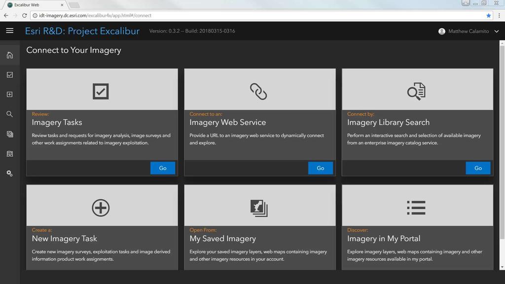
15 Excalibur

16 Web Pattern Exploitation - Excalibur Capabilities: Thin Client Imagery Exploitation Works with Imagery Services Imagery Management Capabilities Phased Exploitation - SOM Image Coordinate Space Obliques Exploitation Templates Availability: Limited Beta Q2, 2018 Limited Rollout Q4, 2018 Fielded as part of Portal with Image Server Requires either a Level 1 or 2 User Prototype Mockup
17
18 Questions


19 ArcGIS for Defence Solutions ArcGIS for Defense provides maps and apps to deliver timely insights, make strategic decisions and conduct tactical operations. Command and Control Intelligence Sustainment

20 Military Tools for ArcGIS available to download now!

21
Migrating Defense Workflows from ArcMap to ArcGIS Pro. Renee Bernstein and Jared Sellers
 Migrating Defense Workflows from ArcMap to ArcGIS Pro Renee Bernstein and Jared Sellers ArcGIS Desktop Desktop Web Device ArcMap ArcCatalog ArcScene ArcGlobe ArcGIS Pro portal Server Online Content and
Esri Training by Microcenter Prepare to Innovate. Microcenter Course Catalog
 Esri Training by Microcenter Prepare to Innovate 2015 Instructor-Led Courses Microcenter Course Catalog ArcGIS Foundational Courses Designed to meet the learning needs of professionals whose GIS experience
ArcGIS Pro Q&A Session. NWGIS Conference, October 11, 2017 With John Sharrard, Esri GIS Solutions Engineer
 ArcGIS Pro Q&A Session NWGIS Conference, October 11, 2017 With John Sharrard, Esri GIS Solutions Engineer jsharrard@esri.com ArcGIS Desktop The applications ArcGIS Pro ArcMap ArcCatalog ArcScene ArcGlobe
Leveraging ArcGIS Online Elevation and Hydrology Services. Steve Kopp, Jian Lange
 Leveraging ArcGIS Online Elevation and Hydrology Services Steve Kopp, Jian Lange Topics An overview of ArcGIS Online Elevation Analysis Using Elevation Analysis Services in ArcGIS for Desktop Using Elevation
Analyzing the Operational Environment
 Esri International User Conference July 23 27 San Diego Convention Center Analyzing the Operational Environment Matthew Funk (Esri) David Mitchell (Esri) Tim Burley (Helyx SIS) Geospatial Enterprise for
ArcGIS is Advancing. Both Contributing and Integrating many new Innovations. IoT. Smart Mapping. Smart Devices Advanced Analytics
 ArcGIS is Advancing IoT Smart Devices Advanced Analytics Smart Mapping Real-Time Faster Computing Web Services Crowdsourcing Sensor Networks Both Contributing and Integrating many new Innovations ArcGIS
Thales Canada, System Division. BattleView: Integrating ArcGIS Into Canadian Army s Command And Control Application
 BattleView: Integrating ArcGIS Into Canadian Army s Command And Control Application BattleView Overview Canadian Army s command and control (C2) application Deployed in army headquarters unit and above
ArcGIS Pro 3D Workflows. Zena Pelletier
 ArcGIS Pro 3D Workflows Zena Pelletier 3D as a GIS capability Core part of the platform Desktop Web Device Combine 2D and 3D in the same web GIS architecture Reuse dynamic services across clients Securely
Introduction to ArcGIS Defense Solutions
 Introduction to ArcGIS Defense Solutions Military Analyst and Military Overlay Editor (MOLE) Presented by Candace Paulman, ESRI Federal User Conference 2008 3 ArcGIS Defense Solutions Logistics Cell phones
Law Enforcement Solutions and Applications
 ArcGIS for Solutions and Applications Solutions and Applications ArcGIS for Platform ArcGIS for Collection of solutions and applications for law enforcement. Built on the ArcGIS platform. For any named
Incorporating ArcGIS Pro in your Curriculum
 AAG, Boston 2017 April 5, 2017 Incorporating ArcGIS Pro in your Curriculum Geri Miller Agenda Concerns Acknowledged Learning curve ArcGIS Pro does not have all the tools (perception) Licensing and offline
Leveraging Web GIS: An Introduction to the ArcGIS portal
 Leveraging Web GIS: An Introduction to the ArcGIS portal Derek Law Product Management DLaw@esri.com Agenda Web GIS pattern Product overview Installation and deployment Configuration options Security options
Esri UC2013. Technical Workshop.
 Esri International User Conference San Diego, California Technical Workshops July 9, 2013 CAD: Introduction to using CAD Data in ArcGIS Jeff Reinhart & Phil Sanchez Agenda Overview of ArcGIS CAD Support
ArcGIS for Defense: Analyzing Environmental Impact on Operations. Jim Weakland John Fry Matt Funk
 ArcGIS for Defense: Analyzing Environmental Impact on Operations Jim Weakland John Fry Matt Funk Terrain and Weather Photo: U.S. Air Force/Senior Airman Areca T. Wilson Photo: Lance Cpl. Preston McDonald
ArcGIS. for Server. Understanding our World
 ArcGIS for Server Understanding our World ArcGIS for Server Create, Distribute, and Manage GIS Services You can use ArcGIS for Server to create services from your mapping and geographic information system
Portal for ArcGIS: An Introduction. Catherine Hynes and Derek Law
 Portal for ArcGIS: An Introduction Catherine Hynes and Derek Law Agenda Web GIS pattern Product overview Installation and deployment Configuration options Security options and groups Portal for ArcGIS
Exelis and Esri Technologies for Defense and National Security. Cherie Muleh
 Exelis and Esri Technologies for Defense and National Security Cherie Muleh Cherie.Muleh@exelisinc.com ENVI IMAGERY AND DATA BECOME KNOWLEDGE > Add information from imagery to your GIS > Automated workflows
ArcGIS for Military: Analyzing the Operational Environment. Matthew Funk Carolyn Fish
 ArcGIS for Military: Analyzing the Operational Environment Matthew Funk Carolyn Fish Geospatial Enterprise for the Military Sensors Operations Server COP Mounted Intelligence Planning Provisioning Dismounted
Web GIS: Architectural Patterns and Practices. Shannon Kalisky Philip Heede
 Web GIS: Architectural Patterns and Practices Shannon Kalisky Philip Heede Web GIS Transformation of the ArcGIS Platform Desktop Apps Server GIS Web Maps Web Scenes Layers Web GIS Transformation of the
Data Aggregation with InfraWorks and ArcGIS for Visualization, Analysis, and Planning
 CI125230 Data Aggregation with InfraWorks and ArcGIS for Visualization, Analysis, and Planning Stephen Brockwell Brockwell IT Consulting Inc. Sean Kinahan Brockwell IT Consulting Inc. Learning Objectives
DP Project Development Pvt. Ltd.
 Dear Sir/Madam, Greetings!!! Thanks for contacting DP Project Development for your training requirement. DP Project Development is leading professional training provider in GIS technologies and GIS application
Esri Production Mapping: Map Automation & Advanced Cartography MADHURA PHATERPEKAR JOE SHEFFIELD
 Esri Production Mapping: Map Automation & Advanced Cartography MADHURA PHATERPEKAR JOE SHEFFIELD Traditional Cartography What you really want Cartographic Workflow Output Cartographic Data Symbology Layout
Data Aggregation with InfraWorks and ArcGIS for Visualization, Analysis, and Planning
 Data Aggregation with InfraWorks and ArcGIS for Visualization, Analysis, and Planning Stephen Brockwell President, Brockwell IT Consulting, Inc. Join the conversation #AU2017 KEYWORD Class Summary Silos
OFWIM 2017 Annual Conference What Does Web GIS Really Mean for Fish and Wildlife Agencies?
 Content Open Mapping OFWIM 2017 Annual Conference What Does Web GIS Really Mean for Fish and Wildlife Agencies? Imagery Spatial Analysis Mike Bialousz, Esri 3D Data Exploration Real-Time Apps Visualization
What s New in Collector for ArcGIS (Aurora)
") What s New in Collector for ArcGIS (Aurora) Derek Law (dlaw@esri.com) Esri Apps Product Management @GIS_Bandit Oct 10 th, 2018 Agenda Product overview Use cases Preparing data for Collector for ArcGIS
What s New in Collector for ArcGIS (Aurora) Derek Law (dlaw@esri.com) Esri Apps Product Management @GIS_Bandit Oct 10 th, 2018 Agenda Product overview Use cases Preparing data for Collector for ArcGIS
Web GIS & ArcGIS Pro. Zena Pelletier Nick Popovich
 Web GIS & ArcGIS Pro Zena Pelletier Nick Popovich Web GIS Transformation of the ArcGIS Platform Desktop Apps GIS Web Maps Web Scenes Layers Evolution of the modern GIS Desktop GIS (standalone GIS) GIS
Enabling ENVI. ArcGIS for Server
 Enabling ENVI throughh ArcGIS for Server 1 Imagery: A Unique and Valuable Source of Data Imagery is not just a base map, but a layer of rich information that can address problems faced by GIS users. >
You are Building Your Organization s Geographic Knowledge
 You are Building Your Organization s Geographic Knowledge And Increasingly Making it Available Sharing Data Publishing Maps and Geo-Apps Developing Collaborative Approaches Citizens Knowledge Workers Analysts
These modules are covered with a brief information and practical in ArcGIS Software and open source software also like QGIS, ILWIS.
 Online GIS Training and training modules covered are: 1. ArcGIS, Analysis, Fundamentals and Implementation 2. ArcGIS Web Data Sharing 3. ArcGIS for Desktop 4. ArcGIS for Server These modules are covered
UNIT 4: USING ArcGIS. Instructor: Emmanuel K. Appiah-Adjei (PhD) Department of Geological Engineering KNUST, Kumasi
 Department of Geological Engineering KNUST, Kumasi") UNIT 4: USING ArcGIS Instructor: Emmanuel K. Appiah-Adjei (PhD) Department of Geological Engineering KNUST, Kumasi Getting to Know ArcGIS ArcGIS is an integrated collection of GIS software products ArcGIS
UNIT 4: USING ArcGIS Instructor: Emmanuel K. Appiah-Adjei (PhD) Department of Geological Engineering KNUST, Kumasi Getting to Know ArcGIS ArcGIS is an integrated collection of GIS software products ArcGIS
An easy-to-use application that lets end users prepare and deploy background maps to your Carmenta based applications.
 Introducing Carmenta Map Builder An easy-to-use application that lets end users prepare and deploy background maps to your Carmenta based applications. Carmenta s geospatial technology is known for its
Oakland County Parks and Recreation GIS Implementation Plan
 Oakland County Parks and Recreation GIS Implementation Plan TABLE OF CONTENTS 1.0 Introduction... 3 1.1 What is GIS? 1.2 Purpose 1.3 Background 2.0 Software... 4 2.1 ArcGIS Desktop 2.2 ArcGIS Explorer
Network Analysis with ArcGIS Online. Deelesh Mandloi Dmitry Kudinov
 Deelesh Mandloi Dmitry Kudinov Introductions Who are we? - Network Analyst Product Engineers Who are you? - Network Analyst users? - ArcGIS Online users? - Trying to figure out what is ArcGIS Online? Slides
Demystifying ArcGIS Online. Karen Lizcano Esri
 Demystifying ArcGIS Online Karen Lizcano Esri An Integrated Web GIS Platform Desktop Web Device Powered by Services Managed via Portal Access from any Device Portal Server Online Content and Services ArcGIS
Performing Map Cartography. using Esri Production Mapping
 AGENDA Performing Map Cartography Presentation Title using Esri Production Mapping Name of Speaker Company Name Kannan Jayaraman Agenda Introduction What s New in ArcGIS 10.1 ESRI Production Mapping Mapping
Introduction to ArcGIS Maps for Office. Greg Ponto Scott Ball
 Introduction to ArcGIS Maps for Office Greg Ponto Scott Ball Agenda What is Maps for Office? Platform overview What are Apps for the Office? ArcGIS Maps for Office features - Visualization - Geoenrichment
Innovation. The Push and Pull at ESRI. September Kevin Daugherty Cadastral/Land Records Industry Solutions Manager
 Innovation The Push and Pull at ESRI September 2004 Kevin Daugherty Cadastral/Land Records Industry Solutions Manager The Push and The Pull The Push is the information technology that drives research and
Esri User Conference 2018 Video Topics
 Esri User Conference 2018 Video Topics 3D GIS 3D Across ArcGIS 3D Analysis Tools in ArcGIS Pro 3D Cartographic Techniques: An Introduction 3D Data: Lidar Point Clouds and 3D Mesh 3D Feature and Sub-Surface
ArcGIS Earth for Enterprises DARRON PUSTAM ARCGIS EARTH CHRIS ANDREWS 3D
 ArcGIS Earth for Enterprises DARRON PUSTAM ARCGIS EARTH CHRIS ANDREWS 3D ArcGIS Earth is ArcGIS Earth is a lightweight globe desktop application that helps you explore any part of the world and investigate
Introduction to ArcGIS Server Development
 Introduction to ArcGIS Server Development Kevin Deege,, Rob Burke, Kelly Hutchins, and Sathya Prasad ESRI Developer Summit 2008 1 Schedule Introduction to ArcGIS Server Rob and Kevin Questions Break 2:15
No. of Days. ArcGIS 3: Performing Analysis ,431. Building 3D cities Using Esri City Engine ,859
 What s New? Creating Story Maps with ArcGIS Field Data Collection and Management Using ArcGIS Get Started with Insights for ArcGIS Introduction to GIS Using ArcGIS & ArcGIS Pro: Essential Workflow Migrating
No. of Days. ArcGIS Pro for GIS Professionals ,431. Building 3D cities Using Esri City Engine ,859
 What s New? Creating Story Maps with ArcGIS Field Data Collection and Management Using ArcGIS Get Started with Insights for ArcGIS Introduction to GIS Using ArcGIS & ArcGIS Pro: Essential Workflow Migrating
ArcGIS Pro: Analysis and Geoprocessing. Nicholas M. Giner Esri Christopher Gabris Blue Raster
 ArcGIS Pro: Analysis and Geoprocessing Nicholas M. Giner Esri Christopher Gabris Blue Raster Agenda What is Analysis and Geoprocessing? Analysis in ArcGIS Pro - 2D (Spatial xy) - 3D (Elevation - z) - 4D
Introduction to ArcGIS Server - Creating and Using GIS Services. Mark Ho Instructor Washington, DC
 Introduction to ArcGIS Server - Creating and Using GIS Services Mark Ho Instructor Washington, DC Technical Workshop Road Map Product overview Building server applications GIS services Developer Help resources
Changes in Esri GIS, practical ways to be ready for the future
 Changes in Esri GIS, practical ways to be ready for the future John Sharrard, Esri April 16, 2015 The only thing that is constant is change. Heraclitus, ca. 500 B.C. My story (of experiencing change) Changes
ArcGIS for Desktop. ArcGIS for Desktop is the primary authoring tool for the ArcGIS platform.
 ArcGIS for Desktop ArcGIS for Desktop ArcGIS for Desktop is the primary authoring tool for the ArcGIS platform. Beyond showing your data as points on a map, ArcGIS for Desktop gives you the power to manage
esri.com/apps Copyright 2017 Esri. All rights reserved.
 ArcGIS Apps esri.com/apps Copyright 2017 Esri. All rights reserved. 159913 G79379 ArcGIS Apps Survey123 for ArcGIS Included with ArcGIS Survey123 for ArcGIS Create survey style forms to capture accurate
Experiences and Directions in National Portals"
 FIG Seminar on e-land Administration Innsbruck/Austria 2-4 June 2004 "ESRI's Experiences and Directions in National Portals" Kevin Daugherty Cadastral/Land Records Manager ESRI Topic Points Technology
Introduction to Portal for ArcGIS
 Introduction to Portal for ArcGIS Derek Law Product Management March 10 th, 2015 Esri Developer Summit 2015 Agenda Web GIS pattern Product overview Installation and deployment Security and groups Configuration
The Pace of Change Is Accelerating Creating Many Challenges
 VISION The Pace of Change Is Accelerating Creating Many Challenges Evidence Threatening Our Natural World and Our Future as Humans Social Conflict Mass Migration Ocean Acidification Food Population Urbanization
The Platform Generation. Derek Law and Ebony Wicks
 The Platform Generation Derek Law and Ebony Wicks GIS Provides the Framework and Process For Applying Geography Analysis and Interpretation Design and Planning Creating Understanding Modeling and Predicting
Web GIS Patterns and Practices
 FedGIS Conference February 24 25, 2016 Washington, DC Web GIS Patterns and Practices Philip Heede Jay Theodore Witt Mathot Web GIS Transformation of the ArcGIS Platform Desktop Apps Web Maps Web Scenes
No. of Days. Building 3D cities Using Esri City Engine ,859. Creating & Analyzing Surfaces Using ArcGIS Spatial Analyst 1 7 3,139
 Q3 What s New? Creating and Editing Data with ArcGIS Pro Editing and Maintaining Parcels Using ArcGIS Spatial Analysis Using ArcGIS Pro User Workflows for ArcGIS Online Organizations Q3-2018 ArcGIS Desktop
This tutorial is intended to familiarize you with the Geomatica Toolbar and describe the basics of viewing data using Geomatica Focus.
 PCI GEOMATICS GEOMATICA QUICKSTART 1. Introduction This tutorial is intended to familiarize you with the Geomatica Toolbar and describe the basics of viewing data using Geomatica Focus. All data used in
ArcGIS Enterprise: What s New. Philip Heede Shannon Kalisky Melanie Summers Shreyas Shinde
 ArcGIS Enterprise: What s New Philip Heede Shannon Kalisky Melanie Summers Shreyas Shinde ArcGIS Enterprise is the new name for ArcGIS for Server ArcGIS Enterprise Software Components ArcGIS Server Portal
Geospatial Products V8i (SELECTseries 1)
") Geospatial Products V8i (SELECTseries 1) Keith Raymond Product Manager Geospatial Desktop Products Presentation Overview What are the various products? Why would you need them? Demonstrations 2 WWW.BENTLEY.COM
Geospatial Products V8i (SELECTseries 1) Keith Raymond Product Manager Geospatial Desktop Products Presentation Overview What are the various products? Why would you need them? Demonstrations 2 WWW.BENTLEY.COM
Geospatial Fire Behavior Modeling App to Manage Wildfire Risk Online. Kenyatta BaRaKa Jackson US Forest Service - Consultant
 Geospatial Fire Behavior Modeling App to Manage Wildfire Risk Online Kenyatta BaRaKa Jackson US Forest Service - Consultant Fire Behavior Modeling and Forest Fuel Management Modeling Fire Behavior is an
Strategies for Integrating CAD and BIM in ArcGIS. Don Kuehne Esri 3D Product Manager: CAD/BIM/AEC
 Strategies for Integrating CAD and BIM in ArcGIS Don Kuehne Esri 3D Product Manager: CAD/BIM/AEC CAD Digital Drawing CAD in ArcGIS Desktop CAD in Desktop CAD as Data CAD as a Map EXPORT TO CAD Create and
GIS for Crime Analysis. Building Better Analysis Capabilities with the ArcGIS Platform
 GIS for Crime Analysis Building Better Analysis Capabilities with the ArcGIS Platform Crime Analysis The Current State One of the foundations of criminological theory is that three things are needed for
Lecture 2. Introduction to ESRI s ArcGIS Desktop and ArcMap
 Lecture 2 Introduction to ESRI s ArcGIS Desktop and ArcMap Outline ESRI What is ArcGIS? ArcGIS Desktop ArcMap Overview Views Layers Attribute Tables Help! Scale Tips and Tricks ESRI Environmental Systems
Esri Defense Mapping: Cartographic Production. Bo King
 Esri Defense Mapping: Cartographic Production Bo King Agenda Esri Defense Mapping: Cartographic Production Solution Overview Desktop Cartographic Production Workflow - Create Rapid Graphic Product On Demand
EnvSci 360 Computer and Analytical Cartography
 EnvSci 360 Computer and Analytical Cartography Lecture 7 Mapping Images, Surfaces, and 3-D Data Brief Overview of Imagery What is Imagery? A spatial data model that defines space as an array of equally
GIS Software. Evolution of GIS Software
 GIS Software The geoprocessing engines of GIS Major functions Collect, store, mange, query, analyze and present Key terms Program collections of instructions to manipulate data Package integrated collection
Geometric Algorithms in GIS
 Geometric Algorithms in GIS GIS Visualization Software Dr. M. Gavrilova GIS Software for Visualization ArcView GEO/SQL Digital Atmosphere AutoDesk Visual_Data GeoMedia GeoExpress CAVE? Visualization in
Web GIS Administration: Tips and Tricks
 EdUC 2017 July 8 th, 2017 Web GIS Administration: Tips and Tricks Geri Miller Agenda Concerns Acknowledged User Management Content Management Monitoring Licensing and logins Sophistication of IT support
ArcGIS Pro: Essential Workflows STUDENT EDITION
 ArcGIS Pro: Essential Workflows STUDENT EDITION Copyright 2018 Esri All rights reserved. Course version 6.0. Version release date August 2018. Printed in the United States of America. The information contained
Esri Training Your Location for Lifelong Learning. Instructor-Led Courses Esri Course Catalog
 Esri Training 2017 2018 Your Location for Lifelong Learning Instructor-Led Courses Esri Course Catalog Find Out More about Esri Training For the latest class schedules and detailed course information and
Web GIS Deployment for Administrators. Vanessa Ramirez Solution Engineer, Natural Resources, Esri
 Web GIS Deployment for Administrators Vanessa Ramirez Solution Engineer, Natural Resources, Esri Agenda Web GIS Concepts Web GIS Deployment Patterns Components of an On-Premises Web GIS Federation of Server
ArcGIS Runtime: Migrating from ArcGIS Engine. Rex Hansen
 ArcGIS Runtime: Migrating from ArcGIS Engine Rex Hansen Thank You to Our Sponsors Migrating from ArcGIS Engine to ArcGIS Runtime ArcGIS Runtime API: new and evolved workflows on all platforms Windows Linux
GPS Mapping with Esri s Collector App. What We ll Cover
 GPS Mapping with Esri s Collector App Part 1: Overview What We ll Cover Part 1: Overview and requirements Part 2: Preparing the data in ArcGIS for Desktop Part 3: Build a web map in ArcGIS Online Part
ARMY ITAM GIS: Automating Standard Army Training Map Production
 ARMY ITAM GIS: Automating Standard Army Training Map Production Douglas Willets ITAM Western Regional Support Center, Center for Environmental Management of Military Lands, Colorado State University, Fort
Esri Overview for Mentor Protégé Program:
 Agenda Passionate About Helping You Succeed Esri Overview for Mentor Protégé Program: Northrop Grumman CSSS Jeff Dawley 3 September 2010 Esri Overview ArcGIS as a System ArcGIS 10 - Map Production - Mobile
New Methods for GeoDesign with ArcGIS and CityEngine. Dr. Özgür Ertac, Prof. Dr. Jörg Schaller, Cristina Mattos Tech. Uni. Munich, Esri Germany
 New Methods for GeoDesign with ArcGIS and CityEngine Dr. Özgür Ertac, Prof. Dr. Jörg Schaller, Cristina Mattos Tech. Uni. Munich, Esri Germany Agenda Evolution in 3D Introduction 3D Across the ArcGIS Platform
Map Application Progression
 Map Application Progression Application Migration with Latest ArcGIS by Dean Chiang California Department of Fish and Wildlife What we do at CDFW Hunting and fishing licensing and regulation Conservation
ArcGIS & Extensions - Synergy of GIS tools. Synergy. Analyze & Visualize
 Using ArcGIS Extensions to Analyze and Visualize data Colin Childs 1 Topics Objectives Synergy Analysis & Visualization ArcGIS Analysis environments Geoprocessing tools Extensions ArcMap The analysis Process
Spatial Analysis with Web GIS. Rachel Weeden
 Spatial Analysis with Web GIS Rachel Weeden Agenda Subhead goes here Introducing ArcGIS Online Spatial Analysis Workflows Scenarios Other Options Resources ArcGIS is a Platform Making mapping and analytics
Troubleshooting Replication and Geodata Services. Liz Parrish & Ben Lin
 Troubleshooting Replication and Geodata Services Liz Parrish & Ben Lin AGENDA: Troubleshooting Replication and Geodata Services Overview Demo Troubleshooting Q & A Overview of Replication Liz Parrish What
ArcGIS Online Routing and Network Analysis. Deelesh Mandloi Matt Crowder
 ArcGIS Online Routing and Network Analysis Deelesh Mandloi Matt Crowder Introductions Who are we? - Members of the Network Analyst development team Who are you? - Network Analyst users? - ArcGIS Online
Technology Exposition Pradeep Thomas Partha Gosh Sreekumar MD Nilendu Purohit Ajit Babar Santanu Dutta
 Technology Exposition Pradeep Thomas Partha Gosh Sreekumar MD Nilendu Purohit Ajit Babar Santanu Dutta ArcGIS Product Components An Integrated System Pro Real-Time Mobile Enterprise Big Data Imagery Continuously
Introduction to Portal for ArcGIS. Hao LEE November 12, 2015
 Introduction to Portal for ArcGIS Hao LEE November 12, 2015 Agenda Web GIS pattern Product overview Installation and deployment Security and groups Configuration options Portal for ArcGIS + ArcGIS for
Geodatabase An Overview
 Federal GIS Conference February 9 10, 2015 Washington, DC Geodatabase An Overview Ralph Denkenberger - esri Session Path The Geodatabase - What is it? - Why use it? - What types are there? Inside the Geodatabase
What is GIS and How Can It Help Me?
 esri European User Conference Madrid 2011 What is GIS and How Can It Help Me? Jaime Nieves Ignacio Vázquez esri spain «Knowing where things are, and why, is essential to rational decision making.» Jack
ArcGIS Enterprise: What s New. Philip Heede Shannon Kalisky Melanie Summers Sam Williamson
 ArcGIS Enterprise: What s New Philip Heede Shannon Kalisky Melanie Summers Sam Williamson ArcGIS Enterprise is the new name for ArcGIS for Server What is ArcGIS Enterprise ArcGIS Enterprise is powerful
ESRI Survey Summit August Clint Brown Director of ESRI Software Products
 ESRI Survey Summit August 2006 Clint Brown Director of ESRI Software Products Cadastral Fabric How does Cadastral fit with Survey? Surveyors process raw field observations Survey measurements define high-order
CAD: Introduction to using CAD Data in ArcGIS. Kyle Williams & Jeff Reinhart
 CAD: Introduction to using CAD Data in ArcGIS Kyle Williams & Jeff Reinhart What we will accomplish today Overview of ArcGIS CAD Support Georeferencing CAD data for ArcGIS How Mapping Specification for
GIS Workshop Data Collection Techniques
 GIS Workshop Data Collection Techniques NOFNEC Conference 2016 Presented by: Matawa First Nations Management Jennifer Duncan and Charlene Wagenaar, Geomatics Technicians, Four Rivers Department QA #: FRG
Managing Imagery and Raster Data Using Mosaic Datasets
 Esri International User Conference San Diego, California Technical Workshops July 25, 2012 Managing Imagery and Raster Data Using Mosaic Datasets Hong Xu, Prashant Mangtani Presentation Overview Introduction
Learning ArcGIS: Introduction to ArcCatalog 10.1
 Learning ArcGIS: Introduction to ArcCatalog 10.1 Estimated Time: 1 Hour Information systems help us to manage what we know by making it easier to organize, access, manipulate, and apply knowledge to the
Geospatial capabilities, spatial data and services provided by Military Geographic Service
 Geospatial capabilities, spatial data and services provided by Military Geographic Service LtC Mariyan Markov PhD CONTENTS 1. INTRODUCTION - Workflow - Data sources remote sensing, direct field observation.
Portal for ArcGIS: An Introduction
 Portal for ArcGIS: An Introduction Derek Law Esri Product Management Esri UC 2014 Technical Workshop Agenda Web GIS pattern Product overview Installation and deployment Security and groups Configuration
What is CERA? Coastal Emergency Risks Assessment
 What is CERA? Coastal Emergency Risks Assessment Visualization tool using OGC standards Displays the outputs from the ADCIRC storm surge model or other coastal models Represents the maps on interactive
What Would John Snow Do (Today)? Part 1
? Part 1") What Would John Snow Do (Today)? Part 1 Tanya Bigos and Derek Law @Tanyabigos @GIS_Bandit Thurs Oct 19 th, 2017 Outline Overview of the ArcGIS Platform Whiteboard discussion Summary Questions A Whole New
What Would John Snow Do (Today)? Part 1 Tanya Bigos and Derek Law @Tanyabigos @GIS_Bandit Thurs Oct 19 th, 2017 Outline Overview of the ArcGIS Platform Whiteboard discussion Summary Questions A Whole New
Session Objectives. Learn how to: Bring georeferenced aerial imagery into Civil 3D. Connect to and import GIS data using various tools and techniques.
 GIS into Civil 3D Data 70th Annual Wisconsin Society of Land Surveyors' Institute January 24, 2019 1 Learn how to: Session Objectives Bring georeferenced aerial imagery into Civil 3D. Connect to and import
Working with ArcGIS Online
 Esri International User Conference San Diego, CA Technical Workshops July 12, 2011 Working with ArcGIS Online Bern Szukalski, Deane Kensok Topics for this Session ArcGIS Online Overview ArcGIS Online Content
Introducing ArcGIS Engine
 1 Introducing ArcGIS Engine ESRI ArcGIS Engine is a platform for building custom standalone geographic information system (GIS) applications that support multiple application programming interfaces (APIs),
ArcGIS Earth an Intro
 ArcGIS Earth an Intro Chris Andrews Product Manager, 3D and ArcGIS Earth Brian Sims 3D Content Lead 3D across the Esri product family ArcGIS Pro 3D Analyst CityEngine ArcGIS for Server ArcGIS Online ArcGIS
Getting Started with Military Analyst for ArcGIS 9.2
 Getting Started with Military Analyst for ArcGIS 9.2 Copyright 2006 ESRI All rights reserved. Printed in the United States of America. The information contained in this document is the exclusive property
Enabling the Image Analyst (IA) to use the geodatabase
 to use the geodatabase") Enabling the Image Analyst (IA) to use the geodatabase Rick Racine, BAE Systems, Reston, VA Stewart Walker, BAE Systems, San Diego, CA 2008 ESRI Federal User Conference, Washington, D.C., 21 February 2610020508
Enabling the Image Analyst (IA) to use the geodatabase Rick Racine, BAE Systems, Reston, VA Stewart Walker, BAE Systems, San Diego, CA 2008 ESRI Federal User Conference, Washington, D.C., 21 February 2610020508
Network Analysis Services in ArcGIS Enterprise. Deelesh Mandloi
 Network Analysis Services in ArcGIS Enterprise Deelesh Mandloi Slides from this demo theater http://esriurl.com/uc17nas Agenda Network Analyst concepts ArcGIS Enterprise publishing workflow - Geoprocessing
Arboretum Explorer: Using GIS to map the Arnold Arboretum
 Arboretum Explorer: Using GIS to map the Arnold Arboretum Donna Tremonte, Arnold Arboretum of Harvard University 2015 Esri User Conference (UC), July 22, 2015 http://arboretum.harvard.edu/explorer Mission