Modeling forest insect infestation: GIS and agentbased
|
|
|
- Christal Andrews
- 5 years ago
- Views:
Transcription
1 Modeling forest insect infestation: GIS and agentbased approaches Taylor Anderson and Suzana Dragićević 2014 Esri Canada s Annual User Conference October 7 th, Toronto, Canada
2 Presentation Overview Emerald Ash Borer Modeling the EAB as a Complex System Cellular Automata Approach Agent Based Model Approach Conclusions and Future Work


3 Emerald Ash Borer (Agrilus planipennis; EAB)

4 EAB is a Complex System Interactions: Elements interact at a local scale to produce global patterns that are difficult to predict Very difficult to model using traditional methods Parrott & Meyer, 2002
5 How can we model EAB as a complex system?
6 Modeling Complex Systems Cellular Automata (CA) Cellular automata is a modeling method, capable of representing complex systems over geographical space, through time Elements of CA Discrete cell grid Discrete cell states Discrete dynamics (temporal iterations) Local interactions (transition rules operating on a predefined neighborhood) Spatial Analysis Spatial Analysis and Modeling and Modeling (SAM) (SAM) Research Research Lab Lab Department Department of Geography, o Geography, Simon Simon Fraser Fraser University, Canada

 (SAM) Research Research Lab Lab Department Department of Geography, o Geography, Simon Simon Fraser Fraser")
7 Environment Agents Modeling Complex Systems Agent-Based Model (ABM) Bottom-up, complex systems modeling approach capable of representing real-world, interacting entities referred to as agents as they interact with each other and their environment Elements of ABM Similar to CA Mobile, agents can move freely and autonomously exchanging information over geographical space Spatial Analysis Spatial Analysis and Modeling and Modeling (SAM) (SAM) Research Research Lab Lab Department Department of Geography, o Geography, Simon Simon Fraser Fraser University, Canada
8 Current EAB Infestation Modeling Statistical modeling methods to represent EAB propagation and understand the climatic and economic relationships associated with EAB spread at: Local scales (BenDor & Metcalf, 2006; BenDor et al., 2006; Mercader et al., 2011) Regional scales (Prasad et al., 2009; Muirhead et al., 2006) Within a US context Does not capture the EAB as a complex spatiotemporal system
9 Objectives (1) Design and development of a model which can capture EAB behavior and forecast complex emergent patterns of EAB spread over space and time. (2) Integrate complex systems approaches including geographic information systems (GIS), CA, and ABM in model design and development. (3) Provide a modeling tool for better understanding, analysis and potential forecast of EAB insect propagation to aid in decision making, management, and eradication.

10 Study Area
11 Determining Ash Tree Susceptibility Fuzzy Logic Used to manage the uncertainty associated with determining ash tree susceptibility Spatial Analysis Spatial Analysis and Modeling and Modeling (SAM) (SAM) Research Research Lab Lab Department Department of Geography, o Geography, Simon Simon Fraser Fraser University, Canada
12 Ash Tree Susceptibility Generation Susceptibility of each ash tree is determined by combining fuzzy criteria using MCE optimization Criteria include (a) distance from infested ash (b) distance from roads (c) distance from highways (d) density of ash in the stand (e) age of ash (f) size of ash (g) wind direction and (h) air temperature

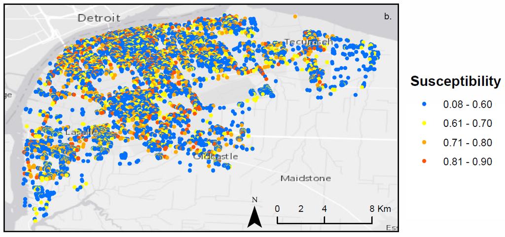
13 Ash Tree Susceptibility Generation


14 Dynamic Simulation using CA
")
15 Model Calibration Accomplished using dataset containing positive locations of EAB infested ash trees provided by the Canadian Food Inspection Agency (CFIA)
16 CA Model Results and Conclusions CA model reveals complex global collective behavior resulting from Active Inactive Active local dynamics between EAB and ash tree host Results demonstrate that the urban environment is most susceptible to EAB infestation Urban Landscape Scenario Rural-Urban Landscape Scenario Rural Landscape Scenario

17 CA Model Disadvantages Limited to the representation of short distance dispersal Use of neighborhood inherent to CA methodology cannot capture long distance dispersal Does not account for population data Does not take the life cycle of the EAB into account


18 EAB Agent-Based Model Represent very small scale local dynamics and interactions between the agent beetle and ash tree landscape object Offers flexibility and mobility Removes neighborhood limitation inherent to CA methodology and captures long distance dispersal


19 Integrating GIS and ABM ABM Recursive Porous Agent Simulation Toolkit is a free open source toolkit used for agent based modeling in application to a variety of ecological and social systems Middleware middleware platform which seamlessly facilitates the integration of ArcGIS (GIS) and Repast Simphony (ABM) GIS spatial analysis, modeling, automating workflows, and visualization of data with the help of a variety of built in tools
20 EAB ABM: Prototype EAB Healthy Tree Infested Tree Programming agents in Repast Simphony Prototype has three major actions or methods Move towards Point with Highest Susceptibility Infest
21 Conclusions and Future Work Complex systems approaches provide a suitable method for modeling spatial dynamics of infestation Major limitation in both approaches with respect to data availability leading to difficulty in model calibration and validation Future work ABM development for capturing refined behaviour and interactions of EAB Integration of CA and ABM for modeling EAB at larger, regional scale
 awarded to Taylor Anderson The datasets were provided by the Canadian Food")
22 Acknowledgements Natural Sciences and Engineering Research Council (NSERC) of Canada: Discovery Grant awarded to Dr. Suzana Dragićević and Canada Graduate Scholarship Masters (CGS-M) awarded to Taylor Anderson The datasets were provided by the Canadian Food and Inspection Agency (CFIA)
. A fuzzy-constrained cellular automata model of forest insect infestations. Ecological Modelling, 192(1-2), 107 125. Canadian Food Inspection Agency (CFIA).")
23 References BenDor, T. K., Metcalf, S. S., Fontenot, L. E., Sangunett, B., & Hannon, B. (2006). Modeling the spread of the Emerald Ash Borer. Ecological Modelling, 197(1-2), Bone, C., Dragicevic, S., & Roberts, A. (2006). A fuzzy-constrained cellular automata model of forest insect infestations. Ecological Modelling, 192(1-2), Canadian Food Inspection Agency (CFIA). (2013). Emerald Ash Borer-Latest Information. Retrieved from Johnston, K. (2013). ArcAnalyst: Agent Based Modeling in ArcGIS. ESRI Press: Redlands, California. Muirhead, J. R., Leung, B., Overdijk, C., Kelly, D. W., Nandakumar, K., Marchant, K. R., & MacIsaac, H. J. (2006). Modelling local and long-distance dispersal of invasive emerald ash borer Agrilus planipennis (Coleoptera) in North America. Diversity and Distributions, 12(1), Mercader, R. J., Siegert, N. W., Liebhold, A. M., & McCullough, D. G. (2011). Simulating the effectiveness of three potential management options to slow the spread of emerald ash borer ( Agrilus planipennis ) populations in localized outlier sites. Canadian Journal of Forest Research, 41(2), Parrott, L., Meyer, W. (2012). Future landscapes: Managing within Complexity. Frontiers in Ecology and the Environment, 10(7), Prasad, A. M., Iverson, L. R., Peters, M. P., Bossenbroek, J. M., Matthews, S. N., Davis Sydnor, T., & Schwartz, M. W. (2009). Modeling the invasive emerald ash borer risk of spread using a spatially explicit cellular model. Landscape Ecology, 25(3), Russell, S. J., Norvig, P., Canny, J. F., Malik, J. M., & Edwards, D. D. (1995). Artificial intelligence: a modern approach (Vol. 2). Englewood Cliffs: Prentice hall.


24 Thank You! Questions? Contact Information: or
Geostatistics and Spatial Scales
 Geostatistics and Spatial Scales Semivariance & semi-variograms Scale dependence & independence Ranges of spatial scales Variable dependent Fractal dimension GIS implications Spatial Modeling Spatial Analysis
A soft computing logic method for agricultural land suitability evaluation
 A soft computing logic method for agricultural land suitability evaluation B. Montgomery 1, S. Dragićević 1* and J. Dujmović 2 1 Geography Department, Simon Fraser University, 8888 University Drive, Burnaby,
INTRODUCTION. In March 1998, the tender for project CT.98.EP.04 was awarded to the Department of Medicines Management, Keele University, UK.
 INTRODUCTION In many areas of Europe patterns of drug use are changing. The mechanisms of diffusion are diverse: introduction of new practices by new users, tourism and migration, cross-border contact,
The Building Blocks of the City: Points, Lines and Polygons
 The Building Blocks of the City: Points, Lines and Polygons Andrew Crooks Centre For Advanced Spatial Analysis andrew.crooks@ucl.ac.uk www.gisagents.blogspot.com Introduction Why use ABM for Residential
Re-imagining Religion: The Spatial Humanities as a Framework for New Scholarship
 2010 Re-imagining Religion: The Spatial Humanities as a Framework for New Scholarship David J. Bodenhamer The Polis Center at IUPUI Virtual Center for Spatial Humanities New Technologies and Interdisciplinary
Python Raster Analysis. Kevin M. Johnston Nawajish Noman
 Python Raster Analysis Kevin M. Johnston Nawajish Noman Outline Managing rasters and performing analysis with Map Algebra How to access the analysis capability - Demonstration Complex expressions and optimization
Cell-based Model For GIS Generalization
 Cell-based Model For GIS Generalization Bo Li, Graeme G. Wilkinson & Souheil Khaddaj School of Computing & Information Systems Kingston University Penrhyn Road, Kingston upon Thames Surrey, KT1 2EE UK
City of Jerez Urban Core Densification proposal; An Agent Based Spatio-temporal model
 Modelling urban population allocation City of Jerez Urban Core Densification proposal; An Agent Based Spatio-temporal model Elke Sauter Julia Úbeda Who we are & why we are here Masters programme: Geographical
A simple agricultural land use model implemented using Geographical Vector Agents (GVA)
") A simple agricultural land use model implemented using Geographical Vector Agents (GVA) A. B. Moore 1, Y. Hammam 2, P. A. Whigham 2 1 School of Surveying / 2 Department of Information Science, University
A simple agricultural land use model implemented using Geographical Vector Agents (GVA) A. B. Moore 1, Y. Hammam 2, P. A. Whigham 2 1 School of Surveying / 2 Department of Information Science, University
Spatial Epidemic Modelling in Social Networks
 Spatial Epidemic Modelling in Social Networks Joana Margarida Simoes Centre for Advanced Spatial Analysis, University College of London, UK Abstract. The spread of infectious diseases is highly influenced
New Frameworks for Urban Sustainability Assessments: Linking Complexity, Information and Policy
 New Frameworks for Urban Sustainability Assessments: Linking Complexity, Information and Policy Moira L. Zellner 1, Thomas L. Theis 2 1 University of Illinois at Chicago, Urban Planning and Policy Program
Computer Simulations
 Computer Simulations A practical approach to simulation Semra Gündüç gunduc@ankara.edu.tr Ankara University Faculty of Engineering, Department of Computer Engineering 2014-2015 Spring Term Ankara University
Linking local multimedia models in a spatially-distributed system
 Linking local multimedia models in a spatially-distributed system I. Miller, S. Knopf & R. Kossik The GoldSim Technology Group, USA Abstract The development of spatially-distributed multimedia models has
Literature revision Agent-based models
 Literature revision Agent-based models Report 12 Universitat Politècnica de Catalunya Centre de Política de Sòl i Valoracions Literature revision Agent-based models Eduardo Chica Mejía Personal de recerca
KING FAHD UNIVERSITY OF PETROLEUM & MINERALS
 KING FAHD UNIVERSITY OF PETROLEUM & MINERALS Department of City & Regional Planning Introduction To GIS (CRP 514) Identifying & Planning Public School Facility In California Using GIS Presented to Dr.
Crime Analysis. GIS Solutions for Intelligence-Led Policing
 Crime Analysis GIS Solutions for Intelligence-Led Policing Applying GIS Technology to Crime Analysis Know Your Community Analyze Your Crime Use Your Advantage GIS aids crime analysis by Identifying and
3/29/11. Why bother with tools? Incorporating Decision Support Tools into Climate Adaptation Planning. A Simplified Planning Process
 Incorporating Decision Support Tools into Climate Adaptation Planning Why bother with tools? Tools don t eliminate complexity but they can help deal with it" Tools can:"! Help incorporate science into
SENSITIVITY ANALYSIS OF A GIS-BASED CELLULAR AUTOMATA MODEL
 SENSITIVITY ANALYSIS OF A GIS-BASED CELLULAR AUTOMATA MODEL V. Kocabas a, *, S. Dragicevic a a Simon Fraser University, Department of Geography, Spatial Analysis Modeling Laboratory 8888 University Dr.,
Agent Based Modeling and Simulation in the Social Sciences. Frank Witmer Computing and Research Services 14 May 2014
 Agent Based Modeling and Simulation in the Social Sciences Frank Witmer Computing and Research Services 14 May 2014 Outline What are agent based models? How do they work? What types of questions are they
Mapping for a Changing California
 Mapping for a Changing California Spatial Data Science: - the 21 st century mapping toolkit - case studies in remote sensing and participatory informatics -where to get more information Maggi Kelly, University
Health and Medical Geography (GEOG 222)
") Spring 2019 Class meets: Tuesdays and Thursdays 12:30-1:45pm Carolina Hall Room 220 Instructor: Michael Emch Email: emch@unc.edu Course Objectives Health and Medical Geography (GEOG 222) This course is
Spring 2019 Class meets: Tuesdays and Thursdays 12:30-1:45pm Carolina Hall Room 220 Instructor: Michael Emch Email: emch@unc.edu Course Objectives Health and Medical Geography (GEOG 222) This course is
Reliability Assessment Electric Utility Mapping. Maged Yackoub Eva Szatmari Veridian Connections Toronto, October 2015
 Reliability Assessment Electric Utility Mapping Maged Yackoub Eva Szatmari Veridian Connections Toronto, October 2015 Agenda Introduction About Veridian Connections Veridian s GIS platform Reliability
Optimizing Urban Modeling based on Road Network and Land Use/Cover Changes by Using Agent Base Cellular Automata Model
 Optimizing Urban Modeling based on Road Network and Land Use/Cover Changes by Using Agent Base Cellular Automata Model Yousef Khajavigodellou 1, A. A. Alesheikh 2, Farshad Hakimpour 3, Kamra Chapi 4 1
A Constrained CA Model to Simulate Urban Growth of the Tokyo Metropolitan Area
 A Constrained CA Model to Simulate Urban Growth of the Tokyo Metropolitan Area Yaolong Zhao 1, 2, Yuji Murayama 2 1 Faculty of Land Resource Engineering, Kunming University of Science and Technology, Kunming,
Time Series Analysis with SAR & Optical Satellite Data
 Time Series Analysis with SAR & Optical Satellite Data Thomas Bahr ESRI European User Conference Thursday October 2015 harris.com Motivation Changes in land surface characteristics mirror a multitude of
A Web-GIS Based Integrated Climate Adaptation Model (ICAM): Exemplification from the City of Melbourne, Australia
: Exemplification from the City of Melbourne, Australia") A Web-GIS Based Integrated Climate Adaptation Model (ICAM): Exemplification from the City of Melbourne, Australia JOSHPHAR KUNAPO 1,2, MATTHEW J. BURNS 1, TIM D. FLETCHER 1, ANTHONY R. LADSON 3, LUKE CUNNINGHAM
A Web-GIS Based Integrated Climate Adaptation Model (ICAM): Exemplification from the City of Melbourne, Australia JOSHPHAR KUNAPO 1,2, MATTHEW J. BURNS 1, TIM D. FLETCHER 1, ANTHONY R. LADSON 3, LUKE CUNNINGHAM
Artificial Intelligence & Sequential Decision Problems
 Artificial Intelligence & Sequential Decision Problems (CIV6540 - Machine Learning for Civil Engineers) Professor: James-A. Goulet Département des génies civil, géologique et des mines Chapter 15 Goulet
DANIEL WILSON AND BEN CONKLIN. Integrating AI with Foundation Intelligence for Actionable Intelligence
 DANIEL WILSON AND BEN CONKLIN Integrating AI with Foundation Intelligence for Actionable Intelligence INTEGRATING AI WITH FOUNDATION INTELLIGENCE FOR ACTIONABLE INTELLIGENCE in an arms race for artificial
Software. People. Data. Network. What is GIS? Procedures. Hardware. Chapter 1
 People Software Data Network Procedures Hardware What is GIS? Chapter 1 Why use GIS? Mapping Measuring Monitoring Modeling Managing Five Ms of Applied GIS Chapter 2 Geography matters Quantitative analyses
The Emerging Role of Enterprise GIS in State Forest Agencies
 The Emerging Role of Enterprise GIS in State Forest Agencies Geographic Information System (GIS) A geographic information system (GIS) is a computer software system designed to capture, store, manipulate,
GEO Geohazards Community of Practice
 GEO Geohazards Community of Practice 1) Co-Chair of GHCP With input from: Stuart Marsh, GHCP Co-Chair Francesco Gaetani, GEO Secretariat and many GHCP contributors 1) Nevada Bureau of Mines and Geology
Automated GIS routine for Strategic Environmental Assessment: a spatiotemporal analysis of urban and wetland change
 Automated GIS routine for Strategic Environmental Assessment: a spatiotemporal analysis of urban and wetland change Anton Sizo 1, Scott Bell 2, and Bram Noble 3 1 Geography and Planning, University of
Space-adjusting Technologies and the Social Ecologies of Place
 Space-adjusting Technologies and the Social Ecologies of Place Donald G. Janelle University of California, Santa Barbara Reflections on Geographic Information Science Session in Honor of Michael Goodchild
Are You Maximizing The Value Of All Your Data?
 Are You Maximizing The Value Of All Your Data? Using The SAS Bridge for ESRI With ArcGIS Business Analyst In A Retail Market Analysis SAS and ESRI: Bringing GIS Mapping and SAS Data Together Presented
GENERALIZATION IN THE NEW GENERATION OF GIS. Dan Lee ESRI, Inc. 380 New York Street Redlands, CA USA Fax:
 GENERALIZATION IN THE NEW GENERATION OF GIS Dan Lee ESRI, Inc. 380 New York Street Redlands, CA 92373 USA dlee@esri.com Fax: 909-793-5953 Abstract In the research and development of automated map generalization,
Sneak Preview of the Saskatchewan Soil Information System (SKSIS)
") Sneak Preview of the Saskatchewan Soil Information System (SKSIS) Angela Bedard-Haughn 1, Ken Van Rees 1, Murray Bentham 1, Paul Krug 1 Kent Walters 1,3, Brandon Heung 2, Tom Jamsrandorj 3 Ralph Deters
Sneak Preview of the Saskatchewan Soil Information System (SKSIS) Angela Bedard-Haughn 1, Ken Van Rees 1, Murray Bentham 1, Paul Krug 1 Kent Walters 1,3, Brandon Heung 2, Tom Jamsrandorj 3 Ralph Deters
Getting Started with Community Maps
 Esri International User Conference San Diego, California Technical Workshops July 24, 2012 Getting Started with Community Maps Shane Matthews and Tamara Yoder Topics for this Session ArcGIS is a complete
Exploring Climate Patterns Embedded in Global Climate Change Datasets
 Exploring Climate Patterns Embedded in Global Climate Change Datasets James Bothwell, May Yuan Department of Geography University of Oklahoma Norman, OK 73019 jamesdbothwell@yahoo.com, myuan@ou.edu Exploring
Biology and life history of Balcha indica, an ectoparasitoid attacking the emerald ash borer, Agrilus planipennis, in North America.
 Biology and life history of Balcha indica, an ectoparasitoid attacking the emerald ash borer, Agrilus planipennis, in North America Jian J. Duan a *, Philip B. Taylor b, and Roger W. Fuester c USDA Agricultural
Spatial multicriteria analysis for home buyers
 Spatial multicriteria analysis for home buyers Xavier Albacete University of Eastern Finland, Department of Environmental Science, Research Group of Environmental Informatics, Yliopistoranta 1 E, P.O.
Research Interests Vulnerability and sustainability indicators, flood hazards, uncertainty analysis, geospatial modeling
 ERIC TATE Assistant Professor Department of Geography, University of Iowa 302 Jessup Hall Iowa City, IA 52242 (319) 335-0259 eric- tate@uiowa.edu www.uiowa.edu/~geog/faculty/tate Research Interests Vulnerability
GLP Workshop on. The design of integrative models of natural and social systems in land change science
 The Global land Project Nodal Office on Integration and Modelling, Aberdeen, UK GLP Workshop on The design of integrative models of natural and social systems in land change science Introduction Post Workshop
Environmental Change Modeling (GIS5306) (Fall 2012) Class meets: Tuesdays 2:30-5 pm, Bellamy 035 Office hour: Tuesdays 1-2 pm or by appointment
 (Fall 2012) Class meets: Tuesdays 2:30-5 pm, Bellamy 035 Office hour: Tuesdays 1-2 pm or by appointment") Environmental Change Modeling (GIS5306) (Fall 2012) Class meets: Tuesdays 2:30-5 pm, Bellamy 035 Office hour: Tuesdays 1-2 pm or by appointment Instructor Dr. Tingting Zhao, Department of Geography, Bellamy
Environmental Change Modeling (GIS5306) (Fall 2012) Class meets: Tuesdays 2:30-5 pm, Bellamy 035 Office hour: Tuesdays 1-2 pm or by appointment Instructor Dr. Tingting Zhao, Department of Geography, Bellamy
Big Data Discovery and Visualisation Insights for ArcGIS
 Big Data Discovery and Visualisation Insights for ArcGIS Create Enrich - Collaborate Lee Kum Cheong GIS CONVERSATIONS At Esri, we believe people can do amazing things with applied geography. GIS CONVERSATIONS
A Method to Reduce the Modifiable Areal Unit Problem in Measuring Urban Form Metrics
 A Method to Reduce the Modifiable Areal Unit Problem in Measuring Urban Form Metrics Dr. Abdul Naser Arafat Keywords: urban, modifiable Areal Unit Problem, Transportation planning, GIS ABSTRACT The relationship
How GIS based Visualizations Support Land Use and Transportation Modeling
 How GIS based Visualizations Support Land Use and Transportation Modeling ESRI International Users Conference San Diego, CA - July 23, 2015 Prepared by: Troy Hightower Introduction This presentation will
USING HYPERSPECTRAL IMAGERY
 USING HYPERSPECTRAL IMAGERY AND LIDAR DATA TO DETECT PLANT INVASIONS 2016 ESRI CANADA SCHOLARSHIP APPLICATION CURTIS CHANCE M.SC. CANDIDATE FACULTY OF FORESTRY UNIVERSITY OF BRITISH COLUMBIA CURTIS.CHANCE@ALUMNI.UBC.CA
Modeling Smart Growth in the Southeast Using Smart-SLEUTH. November 20, 2014 SOUTH ATLANTIC LCC WEB FORUM Monica A. Dorning
 Modeling Smart Growth in the Southeast Using Smart-SLEUTH November 20, 2014 SOUTH ATLANTIC LCC WEB FORUM Monica A. Dorning (Sub)Urbanization in the Southeast November 20, 2014 SOUTH ATLANTIC LCC WEB FORUM
Catalysing Innovation in Weather Science - the role of observations and NWP in the World Weather Research Programme
 Catalysing Innovation in Weather Science - the role of observations and NWP in the World Weather Research Programme Estelle de Coning, Paolo Ruti, Julia Keller World Weather Research Division The World
Aalborg Universitet. Land-use modelling by cellular automata Hansen, Henning Sten. Published in: NORDGI : Nordic Geographic Information
 Aalborg Universitet Land-use modelling by cellular automata Hansen, Henning Sten Published in: NORDGI : Nordic Geographic Information Publication date: 2006 Document Version Publisher's PDF, also known
Dynamic urban modelling: Cellular automata (CA) and Agent-based modelling (ABM) approach
 and Agent-based modelling (ABM) approach") Dynamic urban modelling: Cellular automata (CA) and Agent-based modelling (ABM) approach Agung Wahyudi Spatio-Temporal Analytics Research Laboratory (STAR-Lab) Understanding JMA s urban spatial pattern
Dynamic urban modelling: Cellular automata (CA) and Agent-based modelling (ABM) approach Agung Wahyudi Spatio-Temporal Analytics Research Laboratory (STAR-Lab) Understanding JMA s urban spatial pattern
Modeling Disease Transmission in Long-tailed Macaques on Bali
 Modeling Disease Transmission in Long-tailed Macaques on Bali Kelly Lane Gerhard Niederwieser Ryan Kennedy University of Notre Dame Macaque Background Coexisted in temples across the island for at least
PREFACE FOR THE ENCYCLOPEDIA OF COMPLEXITY AND SYSTEMS SCIENCE
 PREFACE FOR THE ENCYCLOPEDIA OF COMPLEXITY AND SYSTEMS SCIENCE The Encyclopedia of Complexity and System Science is an authoritative single source for understanding and applying the basic tenets of complexity
Climate Risk Visualization for Adaptation Planning and Emergency Response
 Climate Risk Visualization for Adaptation Planning and Emergency Response NCR Flood Fact Finding Workshop Ricardo Saavedra ricardo@vizonomy.com Social Media, Mobile, and Big Data St. Peter s Basilica,
ISO Plant Hardiness Zones Data Product Specification
 ISO 19131 Plant Hardiness Zones Data Product Specification Revision: A Page 1 of 12 Data specification: Plant Hardiness Zones - Table of Contents - 1. OVERVIEW...3 1.1. Informal description...3 1.2. Data
Fire frequency in the Western Cape
 Fire frequency in the Western Cape First year progress report Diane Southey 3 May 27 This report is a summary of the work I have done in the first year of my masters. Each section is briefly discussed
Web Visualization of Geo-Spatial Data using SVG and VRML/X3D
 Web Visualization of Geo-Spatial Data using SVG and VRML/X3D Jianghui Ying Falls Church, VA 22043, USA jying@vt.edu Denis Gračanin Blacksburg, VA 24061, USA gracanin@vt.edu Chang-Tien Lu Falls Church,
AS INTEGRATIVE PLATFORMS FOR CLIMATE CHANGE IMPACT AND ADAPTATION ANALYSIS
 10 PAPER GEOGRAPHIC INFORMATION SYSTEMS AS INTEGRATIVE PLATFORMS FOR CLIMATE CHANGE IMPACT AND ADAPTATION ANALYSIS ROBIN BING RONG 1 and ADAM FENECH 1 1 Adaptation and Impacts Research Division, Environment
World Geography Unit Curriculum Document
 Unit Number and Title: Unit 9-Review (including a comparison to North America) Curriculum Concepts: Globalization Culture Democracy Diversity Migration Enduring Understandings (Big Ideas): Time Frame:
Linear Referencing Systems (LRS) Support for Municipal Asset Management Systems
 Support for Municipal Asset Management Systems") Linear Referencing Systems (LRS) Support for Municipal Asset Management Systems Esri Canada Infrastructure Asset Management Leadership Forum November 1, 2017 Toronto, ON David Loukes, P. Eng., FEC Andy
Linear Referencing Systems (LRS) Support for Municipal Asset Management Systems Esri Canada Infrastructure Asset Management Leadership Forum November 1, 2017 Toronto, ON David Loukes, P. Eng., FEC Andy
Demographic Data in ArcGIS. Harry J. Moore IV
 Demographic Data in ArcGIS Harry J. Moore IV Outline What is demographic data? Esri Demographic data - Real world examples with GIS - Redistricting - Emergency Preparedness - Economic Development Next
Climate Change: Why Worry?
 Climate Change: Why Worry? Lesson Overview Students will explore the meaning of Climate Change, with an emphasis on the impact expected on future human life, the adaptations which will be required, and
Combining Three Modelling and Visualization Tools for Collaborative Planning of Urban Transformation
 152 Combining Three Modelling and Visualization Tools for Collaborative Planning of Urban Transformation Ulrike WISSEN HAYEK 1, Noemi NEUENSCHWANDER 1, Timo VON WIRTH 2, Antje KUNZE 3, Jan HALATSCH 3,
Assessing the impact of seasonal population fluctuation on regional flood risk management
 Assessing the impact of seasonal population fluctuation on regional flood risk management Alan Smith *1, Andy Newing 2, Niall Quinn 3, David Martin 1 and Samantha Cockings 1 1 Geography and Environment,
LAND CHANGE MODELER SOFTWARE FOR ARCGIS
 LAND CHANGE MODELER SOFTWARE FOR ARCGIS The Land Change Modeler is revolutionary land cover change analysis and prediction software which also incorporates tools that allow you to analyze, measure and
University of Lusaka
 University of Lusaka BSPH 315 Health Mapping & GIS Topic: Background of GIS Content: 1. Aim of the course 2. What do you know about GIS? 3. Difference between geographic data and geographic information
Jim Fox. copyright UNC Asheville's NEMAC
 Decisions and System Thinking Jim Fox November, 2012 1 UNC Asheville s s NEMAC National Environmental Modeling and Analysis Center Applied Research and technology development on integration of environmental
What is GIS? G: Geographic, Geospatial, Geo
 GEOG 488/588: GIS I Introduction Instructor: Geoffrey Duh TA: David Graves What is GIS? G: Geographic, Geospatial, Geo Alternatives: Spatial Information Systems, Land Information Systems Geography diverse
Geographic Information Systems (GIS) in Environmental Studies ENVS Winter 2003 Session III
 in Environmental Studies ENVS Winter 2003 Session III") Geographic Information Systems (GIS) in Environmental Studies ENVS 6189 3.0 Winter 2003 Session III John Sorrell York University sorrell@yorku.ca Session Purpose: To discuss the various concepts of space,
Geographic Information Systems (GIS) in Environmental Studies ENVS 6189 3.0 Winter 2003 Session III John Sorrell York University sorrell@yorku.ca Session Purpose: To discuss the various concepts of space,
ANALYSIS OF VARIOUS URBAN GROWTH MODELS BASED ON CELLULAR AUTOMATA
 ANALYSIS OF VARIOUS URBAN GROWTH MODELS BASED ON CELLULAR AUTOMATA Shanthi MadhanMohan 1, S.Ajay Kumar 2, D.Chandrasekhar Reddy 3, S.D.V.Prasad 4, Dr.E.G.Rajan 5 1 Asst.Prof, CSE, Malla Reddy Engineering
Decision-making support tool for promotion policies of abandoned mine areas
 2013 Esri International User Conference July 8 12, 2013 San Diego, California Decision-making support tool for promotion policies of abandoned mine areas Son, Jin Seoul National University Esri UC2013.
Spatial Analysis with ArcGIS Pro STUDENT EDITION
 Spatial Analysis with ArcGIS Pro STUDENT EDITION Copyright 2018 Esri All rights reserved. Course version 2.0. Version release date November 2018. Printed in the United States of America. The information
Spatial Decision Support Systems for policy support in urban planning contexts
 Spatial Decision Support Systems for policy support in urban planning contexts Roel Vanhout P.O. Box 463 6200 AL Maastricht The Netherlands www.riks.nl About RIKS w Independent research institute w Founded
Agent-Based Modeling in ArcGIS. Kevin M. Johnston
 Agent-Based Modeling in ArcGIS Kevin M. Johnston The problem Have a phenomenon that changes with time and space Want to model time and space explicitly not as a snap shot Want to model the interactions
ASSESSMENT. Industry Solutions Harness the Power of GIS for Property Assessment
 ASSESSMENT Industry Solutions Harness the Power of GIS for Property Assessment Esri Canada has thousands of customers worldwide who are using the transforming power of GIS technology to collect, maintain,
Land Accounts - The Canadian Experience
 Land Accounts - The Canadian Experience Development of a Geospatial database to measure the effect of human activity on the environment Who is doing Land Accounts Statistics Canada (national) Component
ArcGIS for Desktop. ArcGIS for Desktop is the primary authoring tool for the ArcGIS platform.
 ArcGIS for Desktop ArcGIS for Desktop ArcGIS for Desktop is the primary authoring tool for the ArcGIS platform. Beyond showing your data as points on a map, ArcGIS for Desktop gives you the power to manage
Lecture 7: Cellular Automata Modelling: Principles of Cell Space Simulation
 SCHOOL OF GEOGRAPHY Lecture 7: Cellular Automata Modelling: Principles of Cell Space Simulation Outline Types of Urban Models Again The Cellular Automata Approach: Urban Growth and Complexity Theory The
Mapping Landscape Change: Space Time Dynamics and Historical Periods.
 Mapping Landscape Change: Space Time Dynamics and Historical Periods. Bess Moylan, Masters Candidate, University of Sydney, School of Geosciences and Archaeological Computing Laboratory e-mail address:
The integration of land change modeling framework FUTURES into GRASS GIS 7
 The integration of land change modeling framework FUTURES into GRASS GIS 7 Anna Petrasova, Vaclav Petras, Douglas A. Shoemaker, Monica A. Dorning, Ross K. Meentemeyer NCSU OSGeo Research and Education
Foundation Geospatial Information to serve National and Global Priorities
 Foundation Geospatial Information to serve National and Global Priorities Greg Scott Inter-Regional Advisor Global Geospatial Information Management United Nations Statistics Division UN-GGIM: A global
Dr.Sinisa Vukicevic Dr. Robert Summers
 Dr.Sinisa Vukicevic Dr. Robert Summers "Planning" means the scientific, aesthetic, and orderly disposition of land, resources, facilities and services with a view to securing the physical, economic and
INTEGRATING DIVERSE CALIBRATION PRODUCTS TO IMPROVE SEISMIC LOCATION
 INTEGRATING DIVERSE CALIBRATION PRODUCTS TO IMPROVE SEISMIC LOCATION ABSTRACT Craig A. Schultz, Steven C. Myers, Jennifer L. Swenson, Megan P. Flanagan, Michael E. Pasyanos, and Joydeep Bhattacharyya Lawrence
Application of Remote Sensing and Global Positioning Technology for Survey and Monitoring of Plant Pests
 Application of Remote Sensing and Global Positioning Technology for Survey and Monitoring of Plant Pests David Bartels, Ph.D. USDA APHIS PPQ CPHST Mission Texas Laboratory Spatial Technology and Plant
Geog 469 GIS Workshop. Data Analysis
 Geog 469 GIS Workshop Data Analysis Outline 1. What kinds of need-to-know questions can be addressed using GIS data analysis? 2. What is a typology of GIS operations? 3. What kinds of operations are useful
USING GIS IN WATER SUPPLY AND SEWER MODELLING AND MANAGEMENT
 USING GIS IN WATER SUPPLY AND SEWER MODELLING AND MANAGEMENT HENRIETTE TAMAŠAUSKAS*, L.C. LARSEN, O. MARK DHI Water and Environment, Agern Allé 5 2970 Hørsholm, Denmark *Corresponding author, e-mail: htt@dhigroup.com
GIS in Weather and Society
 GIS in Weather and Society Olga Wilhelmi Institute for the Study of Society and Environment National Center for Atmospheric Research WAS*IS November 8, 2005 Boulder, Colorado Presentation Outline GIS basic
Urban Climate Resilience
 Urban Climate Resilience in Southeast Asia Partnership Project Introduction Planning for climate change is a daunting challenge for governments in the Mekong Region. Limited capacity at the municipal level,
Prediction of Soil Properties Using Fuzzy Membership
 Prediction of Soil Properties Using Fuzzy Membership Zhu, A.X. 1,2 ; Moore, A. 3 ; Burt, J. E. 2 1 State Key Lab of Resources and Environmental Information System, Institute of Geographical Sciences and
Simulating urban growth in South Asia: A SLEUTH application
 Simulating urban growth in South Asia: A SLEUTH application Gargi Chaudhuri* 1 1 1725 State St., 2022 Cowley Hall, Department of Geography and Earth Science, University of Wisconsin-La Crosse *Email: gchaudhuri@uwlax.edu
Role of GIS in Tracking and Controlling Spread of Disease
 Role of GIS in Tracking and Controlling Spread of Disease For Dr. Baqer Al-Ramadan By Syed Imran Quadri CRP 514: Introduction to GIS Introduction Problem Statement Objectives Methodology of Study Literature
Switching to AQA from Edexcel: Draft Geography AS and A-level (teaching from September 2016)
") Switching to AQA from Edexcel: Draft Geography AS and A-level (teaching from September 2016) If you are thinking of switching from OCR to AQA (from September 2016), this resource is an easy reference guide.
Switching to AQA from Edexcel: Draft Geography AS and A-level (teaching from September 2016) If you are thinking of switching from OCR to AQA (from September 2016), this resource is an easy reference guide.
ArcGIS. for Server. Understanding our World
 ArcGIS for Server Understanding our World ArcGIS for Server Create, Distribute, and Manage GIS Services You can use ArcGIS for Server to create services from your mapping and geographic information system
Land-Use Land-Cover Change Detector
 15 th Esri India User Conference 2014 Land-Use Land-Cover Change Detector Rushikesh Padsala Email ID:- rushikesh101@gmail.com Student, III Semester, M.Tech Geomatics, Faculty of Technology, CEPT University
Population 24/7. David Martin, University of Southampton
 Population 24/7 David Martin, University of Southampton Demographics User Group 18 March 2011 Presentation overview Acknowledgement: Samantha Cockings and Samuel Leung; ESRC award RES-062-23-181 Small
Geography (GEOG) Courses
 Courses") Geography (GEOG) 1 Geography (GEOG) Courses GEOG 100. Introduction to Human Geography. 4 (GE=D4) Introduction to the global patterns and dynamics of such human activities as population growth and movements,
Geography (GEOG) 1 Geography (GEOG) Courses GEOG 100. Introduction to Human Geography. 4 (GE=D4) Introduction to the global patterns and dynamics of such human activities as population growth and movements,
GeoHealth Applications Platform ESRI Health GIS Conference 2013
 GeoHealth Applications Platform ESRI Health GIS Conference 2013 Authors Thomas A. Horan, Ph.D. Professor, CISAT Director April Moreno Health GeoInformatics Ph.D. Student Brian N. Hilton, Ph.D. Clinical
GIScience in Urban Planning Education - Experience from University of Maryland
 GIScience in Urban Planning Education - Experience from University of Maryland February 3, 2007 University of Tokyo Qing Shen Professor of Urban Studies and Planning School of Architecture,
Spatio-temporal models
 Spatio-temporal models Involve a least a three dimensional representation of one or more key attribute variation in planar (X-Y) space and through time. (a 4 th dimension could also be use, like Z for
An Agent Based Modeling Approach to Predicting the Effect of Anthropogenic Pressures on the Movement Patterns of Mongolian Gazelles
 An Agent Based Modeling Approach to Predicting the Effect of Anthropogenic Pressures on the Movement Patterns of Mongolian Gazelles Presenters: Michael Kleyman, Kyle Orlando, William Weston-Dawkes Other