Advancing Machine Learning and AI with Geography and GIS. Robert Kircher
|
|
|
- Frederica Young
- 6 years ago
- Views:
Transcription


1 Advancing Machine Learning and AI with Geography and GIS Robert Kircher

2 Welcome & Thanks

3 GIS is expected to do more, faster. see where find where predict where locate, connect WHERE route where map the unmapped machines can be trained to do more for us
4 Topics Today Emerging Geo AI Business Cases Geo-enabling Machine Learning Landscape and Factory Notable Geo AI challenges and limitations


5 Emerging Geo AI Business Cases Accidents, Anomaly Prediction Predictive Asset Allocation Predictive Routing, ETA, Traffic Predictive GeoMarketing Advanced Feature Extraction Autos Police Landcover Landuse Classification Crops Object Detection Map the Unmapped Protection Risk Management Pollution Exposure Augmented Reality (AR)


6 Industry Advancing Fast (with Geo) Focused Computing GPUs, Devices SaaS, Cloud-based Spatial Statistics Organizations Platforms, On-premises
7 "Gives computers the ability to learn without being explicitly programmed"


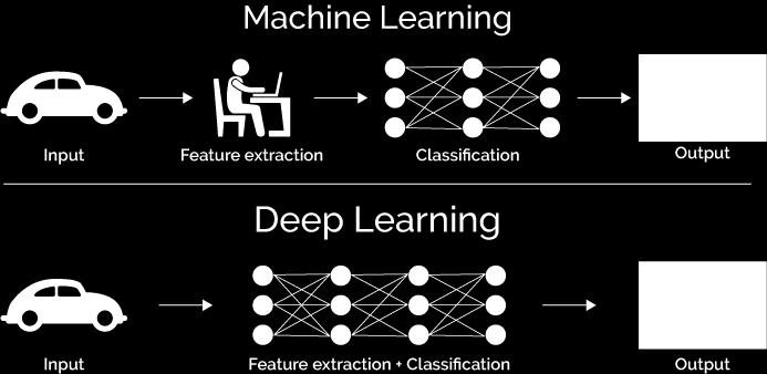

8 AI > ML > DL Artificial Intelligence Machine Learning Deep Learning Supervised Learning Deep Supervised Learning Reasoning Knowledge Representation Perception 1. Training features Labels NLP Robotics Machine Learning 2. Predicting Unsupervised Learning Reinforcement Learning Dog


9 ML Algorithms
10 Data + ML (algo s) (statistics) Models Predictions (inferences) AI AR decisions understanding insights classify
11 ML changes things in exciting ways for GIS evidence based models faster automated data driven accurate tunable platforms pervasive
12 Machine Learning Capabilities Today Emerging ArcGIS


13 Geo ML: Spatial Analytics, Geostatistics, Spatial Statistics, Surfaces
14 Geo-enabled ML or Geo-centric ML
 Features/Labels training Clustering")

15 ML Landscape, Factory and Pattern Data Wrangling/Preparing Model Training/Tuning Share/Deploy Model(s) Use Model(s) Classification Predict, Infer Data Discovery/Create imagery vector business Exploratory Data Analysis (EDA) Features/Labels training Clustering Regression Deep Learning (neural networks) regression Augmented Reality (AR) Computer Vision Visualize, Map It Data Gathering/ Wrangling Recommend Data Preparation ML algorithms neural networks Find/Detect Features data sources Model Validation apps, maps, services, devices
 Use Model(s)")


 ML algorithms 5 4 3 2 1 0")

16 Geo ML Landscape, Factory and Pattern geo-enabling and advancing Data Wrangling/Preparing Model Training/Tuning Share/Deploy Model(s) Use Model(s) Classification Predict, Infer Vast Data Collections, Discovery/Create Expertise imagery Geo Data Sources Structured/Unstructured vector GeoAnalytics business Server Exploratory Maps, Visualization Data Analysis Jupyter/Python/R (EDA) Data Geo-centric Gathering/ Wrangling Datasets Geo-referenced Datasets Localized Datasets Data Geo Preparation CLT Geocoding training Spatial Statistics Spatial Analysis Clustering GP Tools Geo-certify Regression Deep Learning (neural networks) ML algorithms regression neural networks Augmented Reality (AR) Computer Vision Integrated GIS Platform Mapping Platform Visualize, Map It Recommend Find/Detect Features data sources Model Validation apps, maps, services, devices
17 Demo: CAFO Detection Using TensorFlow CNNs to Detect CAFO sites from Satellite Imagery + Consuming the model from ArcGIS Pro Demo Code:
18 Please notice process details Geo Data Preparation Model Training Duration Integrating Model Across GIS Platform Augmented Reality (AR) Recent Demo at Esri (ignore some references) imagine your business problem, your data, your model
19 Some Challenges & Limitations
20 It s complex. Let s simplify it technology, automation, platforms, computing, etc.
21 Look past hype it s distracting prevent another Machine Learning Winter
22 Pred = W 1 A 1 + W 2 A W loc (Location) not fully integrated yet
23 Feature 1 Behavior 1 Traditional Model (Geo-less) Location
24 Limited expertise among Geo Community in training and tuning models math, statistics, spatial statistics Introduce Geo Data Science into industry
25 Limited exposure to Geo in academia Data Science, Computer Science
26 Proving Model Trustworthiness, Authoritativeness
27 (Geo) Data Bias
28 Next Steps
29 Machine Learning needs human analysis to succeed. GIS Community, People, Professionals, Academia.
30 Advancing Geo AI Build on Emerging Business Cases and Geo-enabled ML Patterns Find your place in ML landscape and factory Together, let s continue to overcome Geo AI challenges and limitations

31
DANIEL WILSON AND BEN CONKLIN. Integrating AI with Foundation Intelligence for Actionable Intelligence
 DANIEL WILSON AND BEN CONKLIN Integrating AI with Foundation Intelligence for Actionable Intelligence INTEGRATING AI WITH FOUNDATION INTELLIGENCE FOR ACTIONABLE INTELLIGENCE in an arms race for artificial
The Changing Landscape of Land Administration
 The Changing Landscape of Land Administration B r e n t J o n e s P E, PLS E s r i World s Largest Media Company No Journalists No Content Producers No Photographers World s Largest Hospitality Company
Geo Business Gis In The Digital Organization
 We have made it easy for you to find a PDF Ebooks without any digging. And by having access to our ebooks online or by storing it on your computer, you have convenient answers with geo business gis in
ArcGIS is Advancing. Both Contributing and Integrating many new Innovations. IoT. Smart Mapping. Smart Devices Advanced Analytics
 ArcGIS is Advancing IoT Smart Devices Advanced Analytics Smart Mapping Real-Time Faster Computing Web Services Crowdsourcing Sensor Networks Both Contributing and Integrating many new Innovations ArcGIS
What Would John Snow Do (Today)? Part 1
? Part 1") What Would John Snow Do (Today)? Part 1 Tanya Bigos and Derek Law @Tanyabigos @GIS_Bandit Thurs Oct 19 th, 2017 Outline Overview of the ArcGIS Platform Whiteboard discussion Summary Questions A Whole New
What Would John Snow Do (Today)? Part 1 Tanya Bigos and Derek Law @Tanyabigos @GIS_Bandit Thurs Oct 19 th, 2017 Outline Overview of the ArcGIS Platform Whiteboard discussion Summary Questions A Whole New
Introduction to ArcGIS Maps for Office. Greg Ponto Scott Ball
 Introduction to ArcGIS Maps for Office Greg Ponto Scott Ball Agenda What is Maps for Office? Platform overview What are Apps for the Office? ArcGIS Maps for Office features - Visualization - Geoenrichment
The Pace of Change Is Accelerating Creating Many Challenges
 VISION The Pace of Change Is Accelerating Creating Many Challenges Evidence Threatening Our Natural World and Our Future as Humans Social Conflict Mass Migration Ocean Acidification Food Population Urbanization
DATA SCIENCE SIMPLIFIED USING ARCGIS API FOR PYTHON
 DATA SCIENCE SIMPLIFIED USING ARCGIS API FOR PYTHON LEAD CONSULTANT, INFOSYS LIMITED SEZ Survey No. 41 (pt) 50 (pt), Singapore Township PO, Ghatkesar Mandal, Hyderabad, Telengana 500088 Word Limit of the
Spatial Analysis with Web GIS. Rachel Weeden
 Spatial Analysis with Web GIS Rachel Weeden Agenda Subhead goes here Introducing ArcGIS Online Spatial Analysis Workflows Scenarios Other Options Resources ArcGIS is a Platform Making mapping and analytics
Machine Learning. Boris
 Machine Learning Boris Nadion boris@astrails.com @borisnadion @borisnadion boris@astrails.com astrails http://astrails.com awesome web and mobile apps since 2005 terms AI (artificial intelligence)
OFWIM 2017 Annual Conference What Does Web GIS Really Mean for Fish and Wildlife Agencies?
 Content Open Mapping OFWIM 2017 Annual Conference What Does Web GIS Really Mean for Fish and Wildlife Agencies? Imagery Spatial Analysis Mike Bialousz, Esri 3D Data Exploration Real-Time Apps Visualization
Incorporating ArcGIS Pro in your Curriculum
 AAG, Boston 2017 April 5, 2017 Incorporating ArcGIS Pro in your Curriculum Geri Miller Agenda Concerns Acknowledged Learning curve ArcGIS Pro does not have all the tools (perception) Licensing and offline
An introduction to ArcGIS Maps for Office. Scott Ball & Mike Flanagan
 An introduction to ArcGIS Maps for Office Scott Ball & Mike Flanagan Main takeaways for today Adding the where to your analysis You can learn a lot when you unlock the power of geography in your analytics
TRAITS to put you on the map
 TRAITS to put you on the map Know what s where See the big picture Connect the dots Get it right Use where to say WOW Look around Spread the word Make it yours Finding your way Location is associated with
A Vision for ArcGIS Applying Geography Everywhere
 A Vision for ArcGIS Applying Geography Everywhere WELCOME PURPOSE A Network of GIS Professionals Are Awakening the World to the Power of Web GIS You Your WORK Making a Difference Your Work Open Maps and
Towards Fully-automated Driving
 Towards Fully-automated Driving Challenges and Potential Solutions Dr. Gijs Dubbelman Mobile Perception Systems EE-SPS/VCA Mobile Perception Systems 6 PhDs, postdoc, project manager, software engineer,
Portal for ArcGIS: An Introduction
 Portal for ArcGIS: An Introduction Derek Law Esri Product Management Esri UC 2014 Technical Workshop Agenda Web GIS pattern Product overview Installation and deployment Security and groups Configuration
Introduction to Portal for ArcGIS. Hao LEE November 12, 2015
 Introduction to Portal for ArcGIS Hao LEE November 12, 2015 Agenda Web GIS pattern Product overview Installation and deployment Security and groups Configuration options Portal for ArcGIS + ArcGIS for
ArcGIS Platform For NSOs
 ArcGIS Platform For NSOs Applying GIS and Spatial Thinking to Official Statistics Esri UC 2014 Demo Theater Applying GIS at the NSO Generic Statistical Business Process Model (GSBPM) 1 Specify Needs 2
Quantum Artificial Intelligence and Machine Learning: The Path to Enterprise Deployments. Randall Correll. +1 (703) Palo Alto, CA
 Palo Alto, CA") Quantum Artificial Intelligence and Machine : The Path to Enterprise Deployments Randall Correll randall.correll@qcware.com +1 (703) 867-2395 Palo Alto, CA 1 Bundled software and services Professional
Quantum Artificial Intelligence and Machine : The Path to Enterprise Deployments Randall Correll randall.correll@qcware.com +1 (703) 867-2395 Palo Alto, CA 1 Bundled software and services Professional
You are Building Your Organization s Geographic Knowledge
 You are Building Your Organization s Geographic Knowledge And Increasingly Making it Available Sharing Data Publishing Maps and Geo-Apps Developing Collaborative Approaches Citizens Knowledge Workers Analysts
Web GIS Deployment for Administrators. Vanessa Ramirez Solution Engineer, Natural Resources, Esri
 Web GIS Deployment for Administrators Vanessa Ramirez Solution Engineer, Natural Resources, Esri Agenda Web GIS Concepts Web GIS Deployment Patterns Components of an On-Premises Web GIS Federation of Server
Esri and GIS Education
 Esri and GIS Education Organizations Esri Users 1,200 National Government Agencies 11,500 States & Regional Agencies 30,800 Cities & Local Governments 32,000 Businesses 8,500 Utilities 12,600 NGOs 11,000
Leveraging Web GIS: An Introduction to the ArcGIS portal
 Leveraging Web GIS: An Introduction to the ArcGIS portal Derek Law Product Management DLaw@esri.com Agenda Web GIS pattern Product overview Installation and deployment Configuration options Security options
Web GIS & ArcGIS Pro. Zena Pelletier Nick Popovich
 Web GIS & ArcGIS Pro Zena Pelletier Nick Popovich Web GIS Transformation of the ArcGIS Platform Desktop Apps GIS Web Maps Web Scenes Layers Evolution of the modern GIS Desktop GIS (standalone GIS) GIS
ArcGIS API for Python for Data Scientists. Andrew Chapkowski Alberto Nieto
 ArcGIS API for Python for Data Scientists Andrew Chapkowski Alberto Nieto Analysts, Data Scientists and Developers Source: PyCon India 2018 Python And Data: Past, Present And Future By Peter Wang Why
Web GIS Administration: Tips and Tricks
 EdUC 2017 July 8 th, 2017 Web GIS Administration: Tips and Tricks Geri Miller Agenda Concerns Acknowledged User Management Content Management Monitoring Licensing and logins Sophistication of IT support
ArcGIS Deployment Pattern. Azlina Mahad
 ArcGIS Deployment Pattern Azlina Mahad Agenda Deployment Options Cloud Portal ArcGIS Server Data Publication Mobile System Management Desktop Web Device ArcGIS An Integrated Web GIS Platform Portal Providing
Introduction to Portal for ArcGIS
 Introduction to Portal for ArcGIS Derek Law Product Management March 10 th, 2015 Esri Developer Summit 2015 Agenda Web GIS pattern Product overview Installation and deployment Security and groups Configuration
Better Topographic Map Production Using ArcGIS. A Comprehensive Solution for Mapping Organizations
 Better Topographic Map Production Using ArcGIS A Comprehensive Solution for Mapping Organizations The World Is Always Changing As a member of a national mapping organization, you know this is true. You
June 19 Huntsville, Alabama 1
 June 19 Huntsville, Alabama 1 Real-Time Geospatial Data: The Fusion of PI and ArcGIS Enabling Smarter Facilities Management OSIsoft and Esri Mapping and Location Analytics Platform Supporting Your Use
PAC Learning Introduction to Machine Learning. Matt Gormley Lecture 14 March 5, 2018
 10-601 Introduction to Machine Learning Machine Learning Department School of Computer Science Carnegie Mellon University PAC Learning Matt Gormley Lecture 14 March 5, 2018 1 ML Big Picture Learning Paradigms:
Tasks ADAS. Self Driving. Non-machine Learning. Traditional MLP. Machine-Learning based method. Supervised CNN. Methods. Deep-Learning based
 UNDERSTANDING CNN ADAS Tasks Self Driving Localizati on Perception Planning/ Control Driver state Vehicle Diagnosis Smart factory Methods Traditional Deep-Learning based Non-machine Learning Machine-Learning
esri.com/apps Copyright 2017 Esri. All rights reserved.
 ArcGIS Apps esri.com/apps Copyright 2017 Esri. All rights reserved. 159913 G79379 ArcGIS Apps Survey123 for ArcGIS Included with ArcGIS Survey123 for ArcGIS Create survey style forms to capture accurate
Esri Maps for Office
 2013 Europe, Middle East, and Africa User Conference October 23-25, 2013 Munich, Germany Maps for Office Tony Howser Technical Product Manager Agenda Location Analytics Maps for Office 2.1.2 Road Ahead
ArcGIS. for Server. Understanding our World
 ArcGIS for Server Understanding our World ArcGIS for Server Create, Distribute, and Manage GIS Services You can use ArcGIS for Server to create services from your mapping and geographic information system
GIS for Crime Analysis. Building Better Analysis Capabilities with the ArcGIS Platform
 GIS for Crime Analysis Building Better Analysis Capabilities with the ArcGIS Platform Crime Analysis The Current State One of the foundations of criminological theory is that three things are needed for
ArcGIS for Desktop. ArcGIS for Desktop is the primary authoring tool for the ArcGIS platform.
 ArcGIS for Desktop ArcGIS for Desktop ArcGIS for Desktop is the primary authoring tool for the ArcGIS platform. Beyond showing your data as points on a map, ArcGIS for Desktop gives you the power to manage
ArcGIS Enterprise: What s New. Philip Heede Shannon Kalisky Melanie Summers Sam Williamson
 ArcGIS Enterprise: What s New Philip Heede Shannon Kalisky Melanie Summers Sam Williamson ArcGIS Enterprise is the new name for ArcGIS for Server What is ArcGIS Enterprise ArcGIS Enterprise is powerful
DP Project Development Pvt. Ltd.
 Dear Sir/Madam, Greetings!!! Thanks for contacting DP Project Development for your training requirement. DP Project Development is leading professional training provider in GIS technologies and GIS application
Demystifying ArcGIS Online. Karen Lizcano Esri
 Demystifying ArcGIS Online Karen Lizcano Esri An Integrated Web GIS Platform Desktop Web Device Powered by Services Managed via Portal Access from any Device Portal Server Online Content and Services ArcGIS
ELF products in the ArcGIS platform
 ELF products in the ArcGIS platform Presentation to: Author: Date: NMO Summit 2016, Dublin, Ireland Clemens Portele 18 May 2016 The Building Blocks 18 May, 2016 More ELF users through affiliated platforms
ArcGIS GeoAnalytics Server: An Introduction. Sarah Ambrose and Ravi Narayanan
 ArcGIS GeoAnalytics Server: An Introduction Sarah Ambrose and Ravi Narayanan Overview Introduction Demos Analysis Concepts using GeoAnalytics Server GeoAnalytics Data Sources GeoAnalytics Server Administration
Creating a Staff Development Plan with Esri
 Creating a Staff Development Plan with Esri Michael Green David Schneider Guest Presenter: Shane Feirer, University of California Esri UC 2014 Technical Workshop Agenda What is a Staff Development Plan?
Technology Exposition Pradeep Thomas Partha Gosh Sreekumar MD Nilendu Purohit Ajit Babar Santanu Dutta
 Technology Exposition Pradeep Thomas Partha Gosh Sreekumar MD Nilendu Purohit Ajit Babar Santanu Dutta ArcGIS Product Components An Integrated System Pro Real-Time Mobile Enterprise Big Data Imagery Continuously
Esri Overview for Mentor Protégé Program:
 Agenda Passionate About Helping You Succeed Esri Overview for Mentor Protégé Program: Northrop Grumman CSSS Jeff Dawley 3 September 2010 Esri Overview ArcGIS as a System ArcGIS 10 - Map Production - Mobile
Portal for ArcGIS: An Introduction. Catherine Hynes and Derek Law
 Portal for ArcGIS: An Introduction Catherine Hynes and Derek Law Agenda Web GIS pattern Product overview Installation and deployment Configuration options Security options and groups Portal for ArcGIS
Network Analysis Services in ArcGIS Enterprise. Deelesh Mandloi
 Network Analysis Services in ArcGIS Enterprise Deelesh Mandloi Slides from this demo theater http://esriurl.com/uc17nas Agenda Network Analyst concepts ArcGIS Enterprise publishing workflow - Geoprocessing
UNSUPERVISED LEARNING
 UNSUPERVISED LEARNING Topics Layer-wise (unsupervised) pre-training Restricted Boltzmann Machines Auto-encoders LAYER-WISE (UNSUPERVISED) PRE-TRAINING Breakthrough in 2006 Layer-wise (unsupervised) pre-training
Web GIS: Architectural Patterns and Practices. Shannon Kalisky Philip Heede
 Web GIS: Architectural Patterns and Practices Shannon Kalisky Philip Heede Web GIS Transformation of the ArcGIS Platform Desktop Apps Server GIS Web Maps Web Scenes Layers Web GIS Transformation of the
Machine learning comes from Bayesian decision theory in statistics. There we want to minimize the expected value of the loss function.
 Bayesian learning: Machine learning comes from Bayesian decision theory in statistics. There we want to minimize the expected value of the loss function. Let y be the true label and y be the predicted
Arcgis Enterprise Performance And Scalability Best Practices
 Arcgis Enterprise Performance And Scalability Best Practices We have made it easy for you to find a PDF Ebooks without any digging. And by having access to our ebooks online or by storing it on your computer,
Introduction to Machine Learning
 Introduction to Machine Learning CS4731 Dr. Mihail Fall 2017 Slide content based on books by Bishop and Barber. https://www.microsoft.com/en-us/research/people/cmbishop/ http://web4.cs.ucl.ac.uk/staff/d.barber/pmwiki/pmwiki.php?n=brml.homepage
Esri s Living Atlas of the World Community Maps
 Esri s Living Atlas of the World Community Maps Seth Sarakaitis Wednesday May 7, 2014 ArcGIS Living Atlas Concept Living Atlas Content Tour Contributing to the Living Atlas (Community Maps) Seth Sarakaitis
ArcGIS Data Reviewer: Assessing Positional Accuracy. Roslyn Dunn
 ArcGIS Data Reviewer: Assessing Positional Accuracy Roslyn Dunn What is ArcGIS Data Reviewer? Data Quality Management for ArcGIS Provides - Rule-based validation - Interactive tools - Track errors Validate
The Platform Generation. Derek Law and Ebony Wicks
 The Platform Generation Derek Law and Ebony Wicks GIS Provides the Framework and Process For Applying Geography Analysis and Interpretation Design and Planning Creating Understanding Modeling and Predicting
Geography for the 2020 Round of Census
 Boundaries Key Census Data EA Id Population Male Female EA Id Area EA Id Num HH Avg HH size Geography for the 2020 Round of Census Linda Peters, Esri lpeters@esri.com Integration of Statistical and Geospatial
Probabilistic Graphical Models for Image Analysis - Lecture 1
 Probabilistic Graphical Models for Image Analysis - Lecture 1 Alexey Gronskiy, Stefan Bauer 21 September 2018 Max Planck ETH Center for Learning Systems Overview 1. Motivation - Why Graphical Models 2.
Data Informatics. Seon Ho Kim, Ph.D.
 Data Informatics Seon Ho Kim, Ph.D. seonkim@usc.edu What is Machine Learning? Overview slides by ETHEM ALPAYDIN Why Learn? Learn: programming computers to optimize a performance criterion using example
Machine Learning. Neural Networks. (slides from Domingos, Pardo, others)
") Machine Learning Neural Networks (slides from Domingos, Pardo, others) For this week, Reading Chapter 4: Neural Networks (Mitchell, 1997) See Canvas For subsequent weeks: Scaling Learning Algorithms toward
Machine Learning Neural Networks (slides from Domingos, Pardo, others) For this week, Reading Chapter 4: Neural Networks (Mitchell, 1997) See Canvas For subsequent weeks: Scaling Learning Algorithms toward
GeoAnalytics A key component for insurance industry disruption
 GeoAnalytics A key component for insurance industry disruption Geo Risk Insurance Seminar London, 13th of March 2018 Image: used under license from Shutterstock.com Source: Earthstar Geographics, Esri,
Visualizing Big Data on Maps: Emerging Tools and Techniques. Ilir Bejleri, Sanjay Ranka
 Visualizing Big Data on Maps: Emerging Tools and Techniques Ilir Bejleri, Sanjay Ranka Topics Web GIS Visualization Big Data GIS Performance Maps in Data Visualization Platforms Next: Web GIS Visualization
Deep Learning Lab Course 2017 (Deep Learning Practical)
") Deep Learning Lab Course 207 (Deep Learning Practical) Labs: (Computer Vision) Thomas Brox, (Robotics) Wolfram Burgard, (Machine Learning) Frank Hutter, (Neurorobotics) Joschka Boedecker University of
Deep Learning Lab Course 207 (Deep Learning Practical) Labs: (Computer Vision) Thomas Brox, (Robotics) Wolfram Burgard, (Machine Learning) Frank Hutter, (Neurorobotics) Joschka Boedecker University of
A Statistical Framework for Analysing Big Data Global Conference on Big Data for Official Statistics October, 2015 by S Tam, Chief
 A Statistical Framework for Analysing Big Data Global Conference on Big Data for Official Statistics 20-22 October, 2015 by S Tam, Chief Methodologist Australian Bureau of Statistics 1 Big Data (BD) Issues
Introduction to Spatial Big Data Analytics. Zhe Jiang Office: SEC 3435
 Introduction to Spatial Big Data Analytics Zhe Jiang zjiang@cs.ua.edu Office: SEC 3435 1 What is Big Data? Examples Internet data (images from the web) Earth observation data (nasa.gov) wikimedia.org www.me.mtu.edu
CONTEMPORARY ANALYTICAL ECOSYSTEM PATRICK HALL, SAS INSTITUTE
 CONTEMPORARY ANALYTICAL ECOSYSTEM PATRICK HALL, SAS INSTITUTE Copyright 2013, SAS Institute Inc. All rights reserved. Agenda (Optional) History Lesson 2015 Buzzwords Machine Learning for X Citizen Data
Web GIS Patterns and Practices
 FedGIS Conference February 24 25, 2016 Washington, DC Web GIS Patterns and Practices Philip Heede Jay Theodore Witt Mathot Web GIS Transformation of the ArcGIS Platform Desktop Apps Web Maps Web Scenes
These modules are covered with a brief information and practical in ArcGIS Software and open source software also like QGIS, ILWIS.
 Online GIS Training and training modules covered are: 1. ArcGIS, Analysis, Fundamentals and Implementation 2. ArcGIS Web Data Sharing 3. ArcGIS for Desktop 4. ArcGIS for Server These modules are covered
ECE521 Lecture 7/8. Logistic Regression
 ECE521 Lecture 7/8 Logistic Regression Outline Logistic regression (Continue) A single neuron Learning neural networks Multi-class classification 2 Logistic regression The output of a logistic regression
ArcGIS Online Routing and Network Analysis. Deelesh Mandloi Matt Crowder
 ArcGIS Online Routing and Network Analysis Deelesh Mandloi Matt Crowder Introductions Who are we? - Members of the Network Analyst development team Who are you? - Network Analyst users? - ArcGIS Online
2016 IGIC Conference Workshop/Session Ideas
 ESRI Education GIS Management Topics (i.e. Trends, Roles, Grants, etc) GIS & Technology (i.e. mobile devices, servers, GIS Data Resources (i.e. Indiana Map, local, state, federal, GIS Solutions by Business
Data Aggregation with InfraWorks and ArcGIS for Visualization, Analysis, and Planning
 Data Aggregation with InfraWorks and ArcGIS for Visualization, Analysis, and Planning Stephen Brockwell President, Brockwell IT Consulting, Inc. Join the conversation #AU2017 KEYWORD Class Summary Silos
Cartographic and Geospatial Futures
 Cartographic and Geospatial Futures 1. Web Cartography, WebGIS, & Virtual Globes--New Roles for Maps, GIS, and GIS professionals 2. Map Mashups, the Neo Neo-geography Movement, & Crowd-sourcing Geospatial
IE598 Big Data Optimization Introduction
 IE598 Big Data Optimization Introduction Instructor: Niao He Jan 17, 2018 1 A little about me Assistant Professor, ISE & CSL UIUC, 2016 Ph.D. in Operations Research, M.S. in Computational Sci. & Eng. Georgia
Introduction to Machine Learning Midterm Exam
 10-701 Introduction to Machine Learning Midterm Exam Instructors: Eric Xing, Ziv Bar-Joseph 17 November, 2015 There are 11 questions, for a total of 100 points. This exam is open book, open notes, but
Maryland Transit Administration (MTA) Bus Accident Mapping and Analysis Application
 Bus Accident Mapping and Analysis Application") Maryland Transit Administration (MTA) Bus Accident Mapping and Analysis Application Ralign Wells, MTA Administrator Bernadette Bridges, MTA Chief Safety Officer Office of Safety, Quality Assurance, and
Maryland Transit Administration (MTA) Bus Accident Mapping and Analysis Application Ralign Wells, MTA Administrator Bernadette Bridges, MTA Chief Safety Officer Office of Safety, Quality Assurance, and
Outline. Geographic Information Analysis & Spatial Data. Spatial Analysis is a Key Term. Lecture #1
 Geographic Information Analysis & Spatial Data Lecture #1 Outline Introduction Spatial Data Types: Objects vs. Fields Scale of Attribute Measures GIS and Spatial Analysis Spatial Analysis is a Key Term
Introduction to ArcGIS GeoAnalytics Server. Sarah Ambrose & Noah Slocum
 Introduction to ArcGIS GeoAnalytics Server Sarah Ambrose & Noah Slocum Agenda Overview Analysis Capabilities + Demo Deployment and Configuration Questions ArcGIS GeoAnalytics Server uses the power of distributed
Esri Production Mapping: Map Automation & Advanced Cartography MADHURA PHATERPEKAR JOE SHEFFIELD
 Esri Production Mapping: Map Automation & Advanced Cartography MADHURA PHATERPEKAR JOE SHEFFIELD Traditional Cartography What you really want Cartographic Workflow Output Cartographic Data Symbology Layout
GIS and the Other Enterprise Database
 GIS-T T Symposium GIS and the Other Enterprise Database March 31, 2004 Rapid City, South Dakota 1 Introduction Personal thoughts on recent evolution of GIS Shift in perspective from GIScentric to asset-centric
Creating Basemaps to Manage Buildings and Facilities
 Esri International User Conference San Diego, California Technical Workshops July 26, 2012 Creating Basemaps to Manage Buildings and Facilities Mark Stewart and Tamara Yoder Topics for this Session Overview
Steve Pietersen Office Telephone No
 Steve Pietersen Steve.Pieterson@durban.gov.za Office Telephone No. 031 311 8655 Overview Why geography matters The power of GIS EWS GIS water stats EWS GIS sanitation stats How to build a GIS system EWS
From statistics to data science. BAE 815 (Fall 2017) Dr. Zifei Liu
 Dr. Zifei Liu") From statistics to data science BAE 815 (Fall 2017) Dr. Zifei Liu Zifeiliu@ksu.edu Why? How? What? How much? How many? Individual facts (quantities, characters, or symbols) The Data-Information-Knowledge-Wisdom
From statistics to data science BAE 815 (Fall 2017) Dr. Zifei Liu Zifeiliu@ksu.edu Why? How? What? How much? How many? Individual facts (quantities, characters, or symbols) The Data-Information-Knowledge-Wisdom
Maryland Transit Administration (MTA) Bus Accident Mapping and Analysis Application
 Bus Accident Mapping and Analysis Application") Maryland Transit Administration (MTA) Bus Accident Mapping and Analysis Application Ralign Wells, MTA Administrator Bernadette Bridges, MTA Chief Safety Officer Office of Safety, Quality Assurance, and
Maryland Transit Administration (MTA) Bus Accident Mapping and Analysis Application Ralign Wells, MTA Administrator Bernadette Bridges, MTA Chief Safety Officer Office of Safety, Quality Assurance, and
EEE 241: Linear Systems
 EEE 4: Linear Systems Summary # 3: Introduction to artificial neural networks DISTRIBUTED REPRESENTATION An ANN consists of simple processing units communicating with each other. The basic elements of
michele piana dipartimento di matematica, universita di genova cnr spin, genova
 michele piana dipartimento di matematica, universita di genova cnr spin, genova first question why so many space instruments since we may have telescopes on earth? atmospheric blurring if you want to
9/26/17. Ridge regression. What our model needs to do. Ridge Regression: L2 penalty. Ridge coefficients. Ridge coefficients
 What our model needs to do regression Usually, we are not just trying to explain observed data We want to uncover meaningful trends And predict future observations Our questions then are Is β" a good estimate
A Service Architecture for Processing Big Earth Data in the Cloud with Geospatial Analytics and Machine Learning
 A Service Architecture for Processing Big Earth Data in the Cloud with Geospatial Analytics and Machine Learning WOLFGANG GLATZ & THOMAS BAHR 1 Abstract: The Geospatial Services Framework (GSF) brings
Machine Learning to Automatically Detect Human Development from Satellite Imagery
 Technical Disclosure Commons Defensive Publications Series April 24, 2017 Machine Learning to Automatically Detect Human Development from Satellite Imagery Matthew Manolides Follow this and additional
Getting Started with Community Maps
 Esri International User Conference San Diego, California Technical Workshops July 24, 2012 Getting Started with Community Maps Shane Matthews and Tamara Yoder Topics for this Session ArcGIS is a complete
Machine Learning! in just a few minutes. Jan Peters Gerhard Neumann
 Machine Learning! in just a few minutes Jan Peters Gerhard Neumann 1 Purpose of this Lecture Foundations of machine learning tools for robotics We focus on regression methods and general principles Often
The Underutilization of GIS & How to Cure It. Adam Carnow Esri
 The Underutilization of GIS & How to Cure It Adam Carnow Esri What is GIS? A framework to organize, communicate, and understand the science of our world Business Intelligence (BI) is the set of
Big Data Discovery and Visualisation Insights for ArcGIS
 Big Data Discovery and Visualisation Insights for ArcGIS Create Enrich - Collaborate Lee Kum Cheong GIS CONVERSATIONS At Esri, we believe people can do amazing things with applied geography. GIS CONVERSATIONS
ArcGIS Pro: Analysis and Geoprocessing. Nicholas M. Giner Esri Christopher Gabris Blue Raster
 ArcGIS Pro: Analysis and Geoprocessing Nicholas M. Giner Esri Christopher Gabris Blue Raster Agenda What is Analysis and Geoprocessing? Analysis in ArcGIS Pro - 2D (Spatial xy) - 3D (Elevation - z) - 4D
HIGH RESOLUTION BASE MAP: A CASE STUDY OF JNTUH-HYDERABAD CAMPUS
 HIGH RESOLUTION BASE MAP: A CASE STUDY OF JNTUH-HYDERABAD CAMPUS K.Manjula Vani, Abhinay Reddy, J. Venkatesh, Ballu Harish and R.S. Dwivedi ABSTRACT The proposed work High Resolution Base map: A Case study
Enabling ENVI. ArcGIS for Server
 Enabling ENVI throughh ArcGIS for Server 1 Imagery: A Unique and Valuable Source of Data Imagery is not just a base map, but a layer of rich information that can address problems faced by GIS users. >
Changes in Esri GIS, practical ways to be ready for the future
 Changes in Esri GIS, practical ways to be ready for the future John Sharrard, Esri April 16, 2015 The only thing that is constant is change. Heraclitus, ca. 500 B.C. My story (of experiencing change) Changes
The Emerging Role of Enterprise GIS in State Forest Agencies
 The Emerging Role of Enterprise GIS in State Forest Agencies Geographic Information System (GIS) A geographic information system (GIS) is a computer software system designed to capture, store, manipulate,
LEARNING CREATING RELATIONSHIPS UNDERSTANDING INSPIRING SHARING CONNECTING FUN PURPOSE
 WELCOME LEARNING CREATING RELATIONSHIPS UNDERSTANDING CONNECTING INSPIRING FUN SHARING PURPOSE VISION VISION WE LIVE In a Complex...... and Interconnected World Human Resources Energy Networks Communications
GIS for Business Intelligence: Getting Cloud Connected
 GIS for Business Intelligence: Getting Cloud Connected Ed Farrell Director of GIS Solutions, DVG efarrell@dvginteractive.com http://dvginteractive.com October 19 th, 2017 Lake Placid Convention Center