LEARNING CREATING RELATIONSHIPS UNDERSTANDING INSPIRING SHARING CONNECTING FUN PURPOSE
|
|
|
- Ashley Hutchinson
- 5 years ago
- Views:
Transcription

1

2 WELCOME

3 LEARNING CREATING RELATIONSHIPS UNDERSTANDING CONNECTING INSPIRING FUN SHARING PURPOSE
4 VISION


5 VISION

6 WE LIVE In a Complex and Interconnected World Human Resources Energy Networks Communications Technology Buildings Agriculture Cities Land Uses Transportation Population Nature Oceans Climate Plants Animals Ecosystems Water Atmosphere Constantly Changing...


7 The Pace of Change Is Accelerating Creating Many Challenges Evidence Threatening Our Natural World and Our Future as Humans Social Conflict Mass Migration Ocean Acidification Food Population Urbanization Water We Are Now at a Place Where No Humans Have Been... Deforestation Drought Loss of Biodiversity Pollution Political Polarization Climate Change Energy We Need More Understanding... Collaboration and... Action

8 What Should We Do Next? Apply the Power of Digital Geography Protect Biodiversity Envision What s Possible Improve Productivity and Efficiency Create Sustainable Development Engage Citizens Make Cities Smarter Integrate Environmental Thinking Design with Nature Keep Moving, Learning, and Understanding... Leverage Our Best Technology, Geographic Science, and Holistic Design Thinking


9 Data Management & Integration Visualization & Mapping A Framework and Process Geographic Knowledge Action Decision- Making Analysis & Modeling Planning & Design Leveraging the Power of Geography... to Make Better Decisions
10 Data Management & Integration Visualization & Mapping A Framework and Process Geographic Knowledge Action Decision- Making Analysis & Modeling Planning & Design Leveraging the Power of Geography... to Make Better Decisions


11 What Is GIS Today? A System for Managing, Analyzing, and Applying Geographic Information Understanding Integration Leveraging Location and Technology Analytics Geographic Sciences and Modeling... and Solving Problems Holistically Communication... Maps and Visualization A Platform for Organizations and Society

12 GIS Helps Us Understand Everything Insights... Opening Spatial Analytics to Everyone


13 Types of Analytics Business Value Data Insight Action Diagnostic Analytics Why did it happen? Descriptive Analytics What has happened? Past Present Future Timeframe Prescriptive Analytics What should we do? Predictive Analytics What will happen?


14 Insights Location Analytics and Visualization Visual, Intuitive & Interactive Spatial and Tabular Analysis Many Data Types Charts and Maps Link Analysis Repeat Analysis New and Improved Spreadsheets Databases GIS Data Regression Linked & Responsive Cards Link Analysis Statistical Analysis Dynamic Binning Symbology Charting Tabular Tools Part of ArcGIS Online & Enterprise Data Integration Enabling Exploratory Analysis for Everyone


15 Analytics Paul Voegtle


16 GIS Is Advancing Rapidly Integrating and Leveraging Many Innovations Web GIS Data Computing Easier, Open, and Accessible GIS Innovation Expanding the Power of GIS
17 GIS Is Advancing Rapidly Integrating and Leveraging Many Innovations Web GIS Remote Sensing Scientific Measurements Demographics Weather Lidar Drones Imagery 3D Crowdsourcing Traffic Real-Time Data Easier, Open, and Accessible IoT Full-Motion Video Expanding the Power of GIS
18 GIS Is Advancing Rapidly Integrating and Leveraging Many Innovations Web GIS Easier, Open, and Accessible Computing Mobile Faster Big Data Distributed Computing SaaS Cloud Microservices Networks Web Services Containerization Virtualization Machine Learning / AI Expanding the Power of GIS


19 GIS Is Advancing Rapidly Web GIS Integrating and Leveraging Many Innovations Easier, Open, and Accessible GIS Innovation Real-Time Apps Scripting Imagery 3D Visualization Smart Mapping Predictive Modeling Content Data Exploration Geospatial AI Analytics Distributed Architecture Expanding the Power of GIS


20 Web GIS Is the Modern GIS Architecture Helping Everyone Do Their Work Better Leveraging Web Services Teams Organizations Departments Communities Distributed... and Interconnected Engaging Everyone Individuals Sharing and Collaboration

21 Web GIS Is Driving Digital Transformation Helping Organizations Re-envision Their Workflows Simultaneous Sequential Workflows Integrated Operations Digital Transformation Digital Automation Changing How Organizations as a Whole Do Their Work


22 Web Maps Engage and Interconnect... Everyone Providing a Common Language Supporting Communication and Real-Time Awareness People Organizations Communities A Common Framework... for Collaborating and Problem Solving


23 Collaboration Susan Enyedy-Goldner & Mark Ho


24 ArcGIS Empowers All Aspects of the Organization System of Record Data Management and Integration System of Engagement Sharing, Collaboration, and Dissemination System of Insight Analytics, Models, and Data Exploration... Leveraging the Power of Location


25 ArcGIS Organizes and Manages All Aspects of Geographic Knowledge Data, Information Products, Apps, Models and People and Their Organizations Sites Catalog


26 ArcGIS Enterprise Sites Mark Ho

27 ArcGIS Content A Fundamental Part of the Platform Ecology Agriculture Geology Stream Gauges Water Population Soils Earthquakes Traffic Vegetation Land Cover Landsat Demographics Hazards Weather Sentinel Imagery Thousands of Ready-to-Use Maps and Datasets from Esri Basemaps Topo Maps MODIS Climate Historical Maps Sea Temperature Biology Species Addressing Roads NAIP Elevation DigitalGlobe Landscape Oceans Boundaries Wildfires Rainfall Scientific Planes Lifestyle POIs Protected Areas Distribution Floodplains Stream Forecasts OSM Railroads Millions of Maps and Layers Shared by Users The Foremost Collection of Global Geographic Information A Living Atlas for the Planet


28 ArcGIS Living Atlas World s Largest Digital Map Library Basemaps Watercolor Imagery NDVI Sentinel-2 Nova OpenStreetMap DigitalGlobe GEOS-S & Radar Red Cross Real-Time Observations Antique Terrain Demographics & Geoenrichment EPA Income Average Home Value Population Change Drought Monitor Stream Gauges Wildfire and Wind Curated and Authoritative Source


29 Living Atlas of the World Canada Edition Land Use & Change Drought Monitor Biomass Inventory Agroclimate Impact Reporter Annual Crop Inventory High Resolution DEM Agriculture and Agri-Food Canada Canada Protected Areas The Great Trail Forest Change in Canada Natural Resources Canada Trans Canada Trail Canadian Forest Service Environment & Climate Change Canada


30 Living Atlas of the World Canada Edition Alberta Minerals BC Active Wildfires Yukon Fire Information River & Lake Conditions Alberta Geological Survey BC Wildfire Service Yukon Government Manitoba Government State of Ontario s Watersheds Caribou in Ontario Milieux Humides - sud du Québec Remoteness Index Conservation Ontario & Conservation Authorities Wildlife Conservation Society Canada Canard Illimités Newfoundland and Labrador


31 Living Atlas of the World Go to livingatlas.arcgis.com to Get Started!


32 The Living Atlas Susan Enyedy-Goldner

33 9 Billion 6 Billion Population in 2040 People living in cities


34 1000 buildings per day $3.3T infrastructure spend


35 Autodesk and ArcGIS Providing Direct Product Integration and Interoperability Design & Engineering ArcGIS Pro AutoCAD Revit Direct Read GIS ArcGIS InfraWorks... Integrating Design and Planning Workflows


36 Integrating BIM and GIS Workflows Driving Business with Smarter Decisions Master Planning Regulation & Permitting GIS DATA Preliminary Design & Plan Detailed Design GIS BIM Revenue Generation Monitoring & Enforcement Services Preconstruction Documentation BIM DATA Construction Capital Portfolios Capital Projects


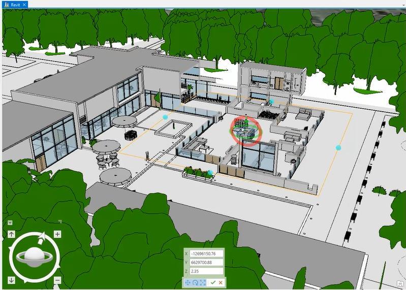

37 Revit Integration Mark Ho


38 What s Next? Massive Transformation... Interconnected Information, Processes, and Workflows All Happening at the Same Time Creating Smart, Dynamic Organizations Using the Power of Location to Integrate Everything


39 Digital Transformation Is Just Beginning... We Are Living in an Era of Exponential Technological Advancement Autonomous Vehicles Persistent Surveillance Location Intelligence Synthetic Biology Remote Sensing Geoplanning Geodesign Automation Immersive Experiences Efficiency and Collaboration Robotics Artificial Intelligence Geospatial Solutions Geoaccounting Open Data Access and Transparency Cloud Computing Smart Devices Real-Time Monitoring Data-Driven Analytics Predictive Analytics Advanced Modeling IoT Pervasive Mapping Internet Web GIS Pervasive Geographic Understanding Web GIS Is Already Playing a Fundamental Role Integrating Geography Into Everything We Do


40 How Do We Take the Next Step? Embrace Digital Transformation and Leverage The Science of Where Create Solutions Innovate Take the Initiative Participate & Take Action Envision a Better Future Work Together Understand the Possibilities Inform & Educate Embrace Technology Learn Continuously... Create a Geoscience-Based Foundation for Our Future


")


41 ArcGIS Solutions Industry-Specific Apps, Maps, and Tools... Extending Your GIS Solution Components Solution Configurations New Popular (500K Downloads) Extensive (450+) Open Source Fully Supported Tools Data Models Apps Workflows Maps Widgets Add-Ins Dashboards Technology Workflows Implementation Training Support Rapidly Delivering Value Implemented by Users, Partners, and Esri


42 Solution Products Directly Supporting Focused Workflows Ready to Use Hub Community Engagement Indoors Spaces, People & Assets New Urban Planning & Development New Works With Your Enterprise GIS


43 ArcGIS Urban Will Revolutionize City Planning and Design New Projects Buildings Infrastructure Immersive and Collaborative Plans Zoning Land Use Transportation Track and Evaluate Projects Create Planning Scenarios Stakeholders Government Digital Twin Indicators Urban Performance Suitability Impact Evaluations Report and Engage Architects Developers Citizens Transforming the Process of Urban Development...


44 ArcGIS Urban Mark Ho


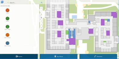
45 ArcGIS Indoors Assemble, Manage, and Share Indoor Information New Portfolio Management Buildings Infrastructure Operations Safety & Security Emergency Management System of Record 3D Maps Wayfinding Employee Routing Public Kiosk Asset Management BIM Integration Real-Time Tracking Problem Reporting Dashboards Wayfinding Stakeholders Business Owners Operators Employees Visitors Floor Plans Complete Indoor Mapping and Location System


46 ArcGIS Indoors Three activities designed to build in-house capabilities New 1 Floor Plan Conversion 2 Stand-Up I P S 3 Configure Apps Build fundamental indoor spatial data using customer data, COTS tools, and critical business systems. Enable indoor positioning systems through existing WAP augmentation, BLE beacons, or LED Lighting As needed support for follow up questions, troubleshooting, recommendations and guidance.


47 ArcGIS Indoors Susan Enyedy-Goldner
48 What s Next? The Road Ahead Incremental Software Releases Continuous Online Improvements Pro Pro Pro 2.3 Big Data BIM Urban IoT Microservices Augmented Reality Industry Solutions Image Exploration Parcel Management AI 3D Effects Volumetric Data Spatiotemporal Terrain Editing Stakeholder Engagement Gaming Engine Predictive Analysis Location Tracking Solution Products Situational Awareness Real-Time Indoor Mapping Integrated Analytic Systems Intuitive Mapping Dynamic Analysis Containerization Machine Learning Oriented Imagery SaaS... Continued Focus on Quality, Performance, and Innovation
49 ArcGIS User Types User Levels Today Level 1 Level 2 Viewing Authoring
50 ArcGIS User Types New User Types Viewer Creator Identical Capabilities Identical Capabilities Viewing Authoring


51 ArcGIS User Types Aligned With What Users Do With GIS Viewer Editor Field Worker Creator New New Viewing Editing Authoring ArcGIS Online December 2018 ArcGIS Enterprise 10.7


52 Professional Development Lifelong Learning GeoNet Community Esri Press Young Professionals Network Podcasts Personal Use License Training Blogs Certification ArcNews & ArcUser Unlimited E-Learning Learning Plans MOOCs Seq ID# 168 sp

53 Partner Ecosystem Committed to Your Success

54 Education Building the Next Generation
55
The Pace of Change Is Accelerating Creating Many Challenges
 VISION The Pace of Change Is Accelerating Creating Many Challenges Evidence Threatening Our Natural World and Our Future as Humans Social Conflict Mass Migration Ocean Acidification Food Population Urbanization
Smart Land Administration. Brent A. Jones, PE, PLS
 Smart Land Administration Brent A. Jones, PE, PLS bjones@esri.com What is Smart? Required Important Modern Open Secure Authoritative Sustainable Cost Effective Reliable Scalable Contributory Usable Timely
OFWIM 2017 Annual Conference What Does Web GIS Really Mean for Fish and Wildlife Agencies?
 Content Open Mapping OFWIM 2017 Annual Conference What Does Web GIS Really Mean for Fish and Wildlife Agencies? Imagery Spatial Analysis Mike Bialousz, Esri 3D Data Exploration Real-Time Apps Visualization
ArcGIS for INSPIRE. Marten Hogeweg Satish Sankaran
 ArcGIS for INSPIRE Marten Hogeweg Satish Sankaran Outline What is ArcGIS ArcGIS for INSPIRE Web GIS Case Studies Roadmap Q&A What is INSPIRE? INSPIRE is the legal framework for a European Spatial Data
A Vision for ArcGIS Applying Geography Everywhere
 A Vision for ArcGIS Applying Geography Everywhere WELCOME PURPOSE A Network of GIS Professionals Are Awakening the World to the Power of Web GIS You Your WORK Making a Difference Your Work Open Maps and
Welcome. C o n n e c t i n g
 Welcome C o n n e c t i n g YOU D i s c i p l i n e s Why is This Meeting......So Important Now? OUR WORLD Is Increasingly Challenged The Evidence Is Clear We Need Better Understanding and More Collaboration
Esri and GIS Education
 Esri and GIS Education Organizations Esri Users 1,200 National Government Agencies 11,500 States & Regional Agencies 30,800 Cities & Local Governments 32,000 Businesses 8,500 Utilities 12,600 NGOs 11,000
ArcGIS is Advancing. Both Contributing and Integrating many new Innovations. IoT. Smart Mapping. Smart Devices Advanced Analytics
 ArcGIS is Advancing IoT Smart Devices Advanced Analytics Smart Mapping Real-Time Faster Computing Web Services Crowdsourcing Sensor Networks Both Contributing and Integrating many new Innovations ArcGIS
ArcGIS Urban: An Introduction. Lisa Staehli ArcGIS Urban Team Product Development Brooks Patrick ArcGIS Urban Team Business Development
 ArcGIS Urban: An Introduction Lisa Staehli ArcGIS Urban Team Product Development Brooks Patrick ArcGIS Urban Team Business Development Our Cities Are Facing Massive Challenges Our Cities Are Facing Massive
June 19 Huntsville, Alabama 1
 June 19 Huntsville, Alabama 1 Real-Time Geospatial Data: The Fusion of PI and ArcGIS Enabling Smarter Facilities Management OSIsoft and Esri Mapping and Location Analytics Platform Supporting Your Use
What is the Living Atlas for ArcGIS and How Can you be Involved?
 Federal GIS Conference February 9 10, 2015 Washington, DC What is the Living Atlas for ArcGIS and How Can you be Involved? Clint Brown Deane Kensok Agenda Introduction to Living Atlas - Transformation
Demystifying ArcGIS Online. Karen Lizcano Esri
 Demystifying ArcGIS Online Karen Lizcano Esri An Integrated Web GIS Platform Desktop Web Device Powered by Services Managed via Portal Access from any Device Portal Server Online Content and Services ArcGIS
Introduction to ArcGIS Maps for Office. Greg Ponto Scott Ball
 Introduction to ArcGIS Maps for Office Greg Ponto Scott Ball Agenda What is Maps for Office? Platform overview What are Apps for the Office? ArcGIS Maps for Office features - Visualization - Geoenrichment
Geo-Enabling Digital India. 15 th Esri India User Conference GIS and Smart Cities
 15 th Esri India User Conference 2014 GIS and Smart Cities 15 th Esri India User Conference 2014 GIS and Smart Cities Agendra Kumar President, Esri India Our World Is Facing Serious Challenges Our World
You are Building Your Organization s Geographic Knowledge
 You are Building Your Organization s Geographic Knowledge And Increasingly Making it Available Sharing Data Publishing Maps and Geo-Apps Developing Collaborative Approaches Citizens Knowledge Workers Analysts
TRAITS to put you on the map
 TRAITS to put you on the map Know what s where See the big picture Connect the dots Get it right Use where to say WOW Look around Spread the word Make it yours Finding your way Location is associated with
ArcGIS. for Server. Understanding our World
 ArcGIS for Server Understanding our World ArcGIS for Server Create, Distribute, and Manage GIS Services You can use ArcGIS for Server to create services from your mapping and geographic information system
Web GIS: Architectural Patterns and Practices. Shannon Kalisky Philip Heede
 Web GIS: Architectural Patterns and Practices Shannon Kalisky Philip Heede Web GIS Transformation of the ArcGIS Platform Desktop Apps Server GIS Web Maps Web Scenes Layers Web GIS Transformation of the
ArcGIS Pro 3D Workflows. Zena Pelletier
 ArcGIS Pro 3D Workflows Zena Pelletier 3D as a GIS capability Core part of the platform Desktop Web Device Combine 2D and 3D in the same web GIS architecture Reuse dynamic services across clients Securely
Reimaging GIS: Geographic Information Society. Clint Brown Linda Beale Mark Harrower Esri
 Reimaging GIS: Geographic Information Society Clint Brown Linda Beale Mark Harrower Esri 8 billion = Number of basemap requests per month on AGOL 14,000 = Unique requests per second 12,000 = New Items
Esri User Conference 2018 Video Topics
 Esri User Conference 2018 Video Topics 3D GIS 3D Across ArcGIS 3D Analysis Tools in ArcGIS Pro 3D Cartographic Techniques: An Introduction 3D Data: Lidar Point Clouds and 3D Mesh 3D Feature and Sub-Surface
Esri Overview for Mentor Protégé Program:
 Agenda Passionate About Helping You Succeed Esri Overview for Mentor Protégé Program: Northrop Grumman CSSS Jeff Dawley 3 September 2010 Esri Overview ArcGIS as a System ArcGIS 10 - Map Production - Mobile
Geography for the 2020 Round of Census
 Boundaries Key Census Data EA Id Population Male Female EA Id Area EA Id Num HH Avg HH size Geography for the 2020 Round of Census Linda Peters, Esri lpeters@esri.com Integration of Statistical and Geospatial
Spatial Data Availability Energizes Florida s Citizens
 NASCIO 2016 Recognition Awards Nomination Spatial Data Availability Energizes Florida s Citizens State of Florida Agency for State Technology & Department of Environmental Protection Category: ICT Innovations
Spatial Analysis with Web GIS. Rachel Weeden
 Spatial Analysis with Web GIS Rachel Weeden Agenda Subhead goes here Introducing ArcGIS Online Spatial Analysis Workflows Scenarios Other Options Resources ArcGIS is a Platform Making mapping and analytics
Key Points Sharing fosters participation and collaboration Metadata has a big role in sharing Sharing is not always easy
 Sharing Resources Geoff Mortson esri, Inc. SDI Solutions Team Key Points Sharing fosters participation and collaboration Metadata has a big role in sharing Sharing is not always easy Data Sharing is Good
Geospatial natural disaster management
 Geospatial natural disaster management disasters happen. are you ready? Natural disasters can strike almost anywhere at any time, with no regard to a municipality s financial resources. These extraordinarily
Connecting Communities. Jeff Peters - Esri
 Connecting Communities Jeff Peters - Esri Public Safety and Security Infrastructure Protection Officer Involved Shootings and Violent Crimes DHS Police Foundation Operation Centers Mail Theft Live Incident
The Underutilization of GIS & How to Cure It. Adam Carnow Esri
 The Underutilization of GIS & How to Cure It Adam Carnow Esri What is GIS? A framework to organize, communicate, and understand the science of our world Business Intelligence (BI) is the set of
US National Spatial Data Infrastructure A Spatial Framework for Governance and Policy Development to Enable a Location-Based Digital Ecosystem
 GeoPlatform Workshop 7 Dec 2016, Department of the Interior Washington, D.C. US National Spatial Infrastructure A Spatial Framework for Governance and Policy Development to Enable a Location-Based Digital
Esri s Living Atlas of the World Community Maps
 Esri s Living Atlas of the World Community Maps Seth Sarakaitis Wednesday May 7, 2014 ArcGIS Living Atlas Concept Living Atlas Content Tour Contributing to the Living Atlas (Community Maps) Seth Sarakaitis
Advancing Machine Learning and AI with Geography and GIS. Robert Kircher
 Advancing Machine Learning and AI with Geography and GIS Robert Kircher rkircher@esri.com Welcome & Thanks GIS is expected to do more, faster. see where find where predict where locate, connect WHERE route
Web GIS & ArcGIS Pro. Zena Pelletier Nick Popovich
 Web GIS & ArcGIS Pro Zena Pelletier Nick Popovich Web GIS Transformation of the ArcGIS Platform Desktop Apps GIS Web Maps Web Scenes Layers Evolution of the modern GIS Desktop GIS (standalone GIS) GIS
ArcGIS Enterprise: What s New. Philip Heede Shannon Kalisky Melanie Summers Sam Williamson
 ArcGIS Enterprise: What s New Philip Heede Shannon Kalisky Melanie Summers Sam Williamson ArcGIS Enterprise is the new name for ArcGIS for Server What is ArcGIS Enterprise ArcGIS Enterprise is powerful
SCAUG Community Maps Building a Living Atlas of the World
 SCAUG Community Maps Building a Living Atlas of the World Mark Stewart Topics: SCAUG ArcGIS Online Overview Community Maps Overview Community Maps Workflow Update Process Utilizing Your Contribution Community
Working with ArcGIS Online
 Esri International User Conference San Diego, CA Technical Workshops July 12, 2011 Working with ArcGIS Online Bern Szukalski, Deane Kensok Topics for this Session ArcGIS Online Overview ArcGIS Online Content
ArcGIS Platform For NSOs
 ArcGIS Platform For NSOs Applying GIS and Spatial Thinking to Official Statistics Esri UC 2014 Demo Theater Applying GIS at the NSO Generic Statistical Business Process Model (GSBPM) 1 Specify Needs 2
GIS for Crime Analysis. Building Better Analysis Capabilities with the ArcGIS Platform
 GIS for Crime Analysis Building Better Analysis Capabilities with the ArcGIS Platform Crime Analysis The Current State One of the foundations of criminological theory is that three things are needed for
GIS and Governing Anchorage. GIS Critical for Efficient, Transparent Government How is GIS Program Doing Where can GIS Program Take us
 GIS and Governing Anchorage GIS Critical for Efficient, Transparent Government How is GIS Program Doing Where can GIS Program Take us Municipality of Anchorage Office of Economic And Community Development
NOMAD Workshop Linking Humanitarian Organizations with Mobile Data Collection Tool Providers, 15 th -17 th May, Paris!
 NOMAD Workshop Linking Humanitarian Organizations with Mobile Data Collection Tool Providers, 15 th -17 th May, Paris! Their Work is Contributing to build a Better World... IAEA UNODC Public Health Global
Introduction to Portal for ArcGIS
 Introduction to Portal for ArcGIS Derek Law Product Management March 10 th, 2015 Esri Developer Summit 2015 Agenda Web GIS pattern Product overview Installation and deployment Security and groups Configuration
ESRI Survey Summit August Clint Brown Director of ESRI Software Products
 ESRI Survey Summit August 2006 Clint Brown Director of ESRI Software Products Cadastral Fabric How does Cadastral fit with Survey? Surveyors process raw field observations Survey measurements define high-order
esri.com/apps Copyright 2017 Esri. All rights reserved.
 ArcGIS Apps esri.com/apps Copyright 2017 Esri. All rights reserved. 159913 G79379 ArcGIS Apps Survey123 for ArcGIS Included with ArcGIS Survey123 for ArcGIS Create survey style forms to capture accurate
Tools to Assess Local Health Needs. Richard Leadbeater, Esri NACo 2011 Healthy Counties Forum December 1, 2011
 Tools to Assess Local Health Needs Richard Leadbeater, Esri NACo 2011 Healthy Counties Forum December 1, 2011 Richard Leadbeater currently holds the position of Industry Solutions Manager with Esri. He
Incorporating ArcGIS Pro in your Curriculum
 AAG, Boston 2017 April 5, 2017 Incorporating ArcGIS Pro in your Curriculum Geri Miller Agenda Concerns Acknowledged Learning curve ArcGIS Pro does not have all the tools (perception) Licensing and offline
A Broad View of Geospatial Technology & Systems
 A Broad View of Geospatial Technology & Systems Pete Large Vice President, Trimble On the shoulders of giants 1 Since their time, our ability to generate geospatial information has grown exponentially
SUPPORTS SUSTAINABLE GROWTH
 DDSS BBUUN NDDLLEE G E O S P AT I A L G O V E R N A N C E P A C K A G E SUPPORTS SUSTAINABLE GROWTH www.digitalglobe.com BRISBANE, AUSTRALIA WORLDVIEW-3 30 CM International Civil Government Programs US
ENV208/ENV508 Applied GIS. Week 1: What is GIS?
 ENV208/ENV508 Applied GIS Week 1: What is GIS? 1 WHAT IS GIS? A GIS integrates hardware, software, and data for capturing, managing, analyzing, and displaying all forms of geographically referenced information.
Strategies for Integrating CAD and BIM in ArcGIS. Don Kuehne Esri 3D Product Manager: CAD/BIM/AEC
 Strategies for Integrating CAD and BIM in ArcGIS Don Kuehne Esri 3D Product Manager: CAD/BIM/AEC CAD Digital Drawing CAD in ArcGIS Desktop CAD in Desktop CAD as Data CAD as a Map EXPORT TO CAD Create and
ArcGIS for Desktop. ArcGIS for Desktop is the primary authoring tool for the ArcGIS platform.
 ArcGIS for Desktop ArcGIS for Desktop ArcGIS for Desktop is the primary authoring tool for the ArcGIS platform. Beyond showing your data as points on a map, ArcGIS for Desktop gives you the power to manage
Evaluating e-government : implementing GIS services in Municipality
 Evaluating e-government : implementing GIS services in Municipality Municipality of Thessaloniki - G.I.S. Unit Misirloglou Symeon Head of the GIS Unit ESRI UC - 2016 The GIS Section - subset of the department
Leveraging Web GIS: An Introduction to the ArcGIS portal
 Leveraging Web GIS: An Introduction to the ArcGIS portal Derek Law Product Management DLaw@esri.com Agenda Web GIS pattern Product overview Installation and deployment Configuration options Security options
Living Atlas: Road Ahead. Deane Kensok Sean Breyer
 Living Atlas: Road Ahead Deane Kensok Sean Breyer Workshop Agenda Subhead Here Overview of the Living Atlas Esri Content Portfolio - Overview - Road Map for 2017 and Beyond - Demos: Previews of Online
Data Aggregation with InfraWorks and ArcGIS for Visualization, Analysis, and Planning
 Data Aggregation with InfraWorks and ArcGIS for Visualization, Analysis, and Planning Stephen Brockwell President, Brockwell IT Consulting, Inc. Join the conversation #AU2017 KEYWORD Class Summary Silos
Features and Benefits
 Autodesk LandXplorer Features and Benefits Use the Autodesk LandXplorer software family to help improve decision making, lower costs, view and share changes, and avoid the expense of creating physical
ArcGIS for INSPIRE. Marten Hogeweg
 ArcGIS for INSPIRE Marten Hogeweg Please Take Our Survey on the App Download the Esri Events app and find your event Select the session you attended Scroll down to find the feedback section Complete answers
Web GIS Patterns and Practices
 FedGIS Conference February 24 25, 2016 Washington, DC Web GIS Patterns and Practices Philip Heede Jay Theodore Witt Mathot Web GIS Transformation of the ArcGIS Platform Desktop Apps Web Maps Web Scenes
Law Enforcement Solutions and Applications
 ArcGIS for Solutions and Applications Solutions and Applications ArcGIS for Platform ArcGIS for Collection of solutions and applications for law enforcement. Built on the ArcGIS platform. For any named
Leveraging the Technology Revolution
 Leveraging the Technology Revolution Science, technology, and innovation to measure and monitor progress Moxie Zhang 张剑宇 We are living in a world that is constantly under development Our World Is full
Creating a Staff Development Plan with Esri
 Creating a Staff Development Plan with Esri Michael Green David Schneider Guest Presenter: Shane Feirer, University of California Esri UC 2014 Technical Workshop Agenda What is a Staff Development Plan?
Designing smart & Resilient cities:
 Designing smart & Resilient cities: How can Egyptian cities learn from an emerging global practice On the Cuspof Change Professor Samer Bagaeen FRICS MRTPI FRSA AoU 1. GLOBAL CHALLENGES POPULATION GROWTH,
The Platform Generation. Derek Law and Ebony Wicks
 The Platform Generation Derek Law and Ebony Wicks GIS Provides the Framework and Process For Applying Geography Analysis and Interpretation Design and Planning Creating Understanding Modeling and Predicting
An introduction to ArcGIS Maps for Office. Scott Ball & Mike Flanagan
 An introduction to ArcGIS Maps for Office Scott Ball & Mike Flanagan Main takeaways for today Adding the where to your analysis You can learn a lot when you unlock the power of geography in your analytics
You Part of a Global Network of GIS Businesses. Your Work Making a Difference. Understanding Our World, with Web GIS, SDI and 3D
 Understanding Our World, with Web GIS, SDI and 3D Paul Hardy, Esri phardy@esri.com You Part of a Global Network of GIS Businesses XIV International User Conference of GeoInformation Systems & Remote Sensing,
The Emerging Role of Enterprise GIS in State Forest Agencies
 The Emerging Role of Enterprise GIS in State Forest Agencies Geographic Information System (GIS) A geographic information system (GIS) is a computer software system designed to capture, store, manipulate,
Advanced Image Analysis in Disaster Response
 Advanced Image Analysis in Disaster Response Creating Geographic Knowledge Thomas Harris ITT The information contained in this document pertains to software products and services that are subject to the
Geospatial SDI Portal for effective Governance of Pune METROPOLIS region
 Geospatial SDI Portal for effective Governance of Pune METROPOLIS region Mr. Praveen Gautam Senior Manager 19 th January 2018 PMRDA Overview Provide a Spatial Framework for the entire region with various
Discovery and Access of Geospatial Resources using the Geoportal Extension. Marten Hogeweg Geoportal Extension Product Manager
 Discovery and Access of Geospatial Resources using the Geoportal Extension Marten Hogeweg Geoportal Extension Product Manager DISCOVERY AND ACCESS USING THE GEOPORTAL EXTENSION Geospatial Data Is Very
GIS Changing the World GIS Day November 15, 2017
 + GIS Changing the World GIS Day November 15, 2017 + Growing Up On The Farm 3 Geographic Information in DNR A 75 year history of mapping and GIS. Forest type map from 1944. State of Washington - Division
USGS National Geospatial Program Understanding User Needs. Dick Vraga National Map Liaison for Federal Agencies July 2015
 + USGS National Geospatial Program Understanding User Needs Dick Vraga National Map Liaison for Federal Agencies July 2015 + Topics 2 Background Communities of Use User Surveys National Map Liaisons Partnerships
What Would John Snow Do (Today)? Part 1
? Part 1") What Would John Snow Do (Today)? Part 1 Tanya Bigos and Derek Law @Tanyabigos @GIS_Bandit Thurs Oct 19 th, 2017 Outline Overview of the ArcGIS Platform Whiteboard discussion Summary Questions A Whole New
What Would John Snow Do (Today)? Part 1 Tanya Bigos and Derek Law @Tanyabigos @GIS_Bandit Thurs Oct 19 th, 2017 Outline Overview of the ArcGIS Platform Whiteboard discussion Summary Questions A Whole New
Introduction to Portal for ArcGIS. Hao LEE November 12, 2015
 Introduction to Portal for ArcGIS Hao LEE November 12, 2015 Agenda Web GIS pattern Product overview Installation and deployment Security and groups Configuration options Portal for ArcGIS + ArcGIS for
Conference panel Session 98, Defining Data Professionals A Geospatial Industry Perspective on Becoming a Data Professional
 Conference panel Session 98, Defining Data Professionals A Geospatial Industry Perspective on Becoming a Data Professional Dawn J. Wright, Environmental Systems Research Institute (aka Esri), Redlands,
Portal for ArcGIS: An Introduction. Catherine Hynes and Derek Law
 Portal for ArcGIS: An Introduction Catherine Hynes and Derek Law Agenda Web GIS pattern Product overview Installation and deployment Configuration options Security options and groups Portal for ArcGIS
An Industry Perspective. Bryn Fosburgh Vice President Trimble
 An Industry Perspective Bryn Fosburgh Vice President Trimble Who are we? Professionals & Consultants Geospatial Professionals working at or with: AEC Consultants Transportation Departments Construction
DATA SCIENCE SIMPLIFIED USING ARCGIS API FOR PYTHON
 DATA SCIENCE SIMPLIFIED USING ARCGIS API FOR PYTHON LEAD CONSULTANT, INFOSYS LIMITED SEZ Survey No. 41 (pt) 50 (pt), Singapore Township PO, Ghatkesar Mandal, Hyderabad, Telengana 500088 Word Limit of the
Portal for ArcGIS: An Introduction
 Portal for ArcGIS: An Introduction Derek Law Esri Product Management Esri UC 2014 Technical Workshop Agenda Web GIS pattern Product overview Installation and deployment Security and groups Configuration
STEREO ANALYST FOR ERDAS IMAGINE Stereo Feature Collection for the GIS Professional
 STEREO ANALYST FOR ERDAS IMAGINE Stereo Feature Collection for the GIS Professional STEREO ANALYST FOR ERDAS IMAGINE Has Your GIS Gone Flat? Hexagon Geospatial takes three-dimensional geographic imaging
Maryland State Geographic Information Committee
 MD IMAP 3.0 Next generation of MD imap platform running on Esri s ArcGIS Enterprise Promoting authoritative data sharing among State agencies via Portal for ArcGIS Centralization of GIS infrastructure
GIS in Weather and Society
 GIS in Weather and Society Olga Wilhelmi Institute for the Study of Society and Environment National Center for Atmospheric Research WAS*IS November 8, 2005 Boulder, Colorado Presentation Outline GIS basic
STATE GEOGRAPHIC INFORMATION DATABASE
 STATE GEOGRAPHIC INFORMATION DATABASE Data Information and Knowledge Management STATE GEOGRAPHIC INFORMATION DATABASE EXECUTIVE SUMMARY Utah has developed one of the most comprehensive statewide GIS resources
New Methods for GeoDesign with ArcGIS and CityEngine. Dr. Özgür Ertac, Prof. Dr. Jörg Schaller, Cristina Mattos Tech. Uni. Munich, Esri Germany
 New Methods for GeoDesign with ArcGIS and CityEngine Dr. Özgür Ertac, Prof. Dr. Jörg Schaller, Cristina Mattos Tech. Uni. Munich, Esri Germany Agenda Evolution in 3D Introduction 3D Across the ArcGIS Platform
GEOGRAPHIC INFORMATION SYSTEMS Session 8
 GEOGRAPHIC INFORMATION SYSTEMS Session 8 Introduction Geography underpins all activities associated with a census Census geography is essential to plan and manage fieldwork as well as to report results
The Federal Geospatial Platform (FGP) and Open Maps Canada. Eric Loubier, Director Natural Resources Canada Earth Sciences Sector
 and Open Maps Canada. Eric Loubier, Director Natural Resources Canada Earth Sciences Sector") The Federal Geospatial Platform (FGP) and Open Maps Canada Eric Loubier, Director Natural Resources Canada Earth Sciences Sector May 2016 Geospatial data are produced and widely used in the federal government
The Federal Geospatial Platform (FGP) and Open Maps Canada Eric Loubier, Director Natural Resources Canada Earth Sciences Sector May 2016 Geospatial data are produced and widely used in the federal government
The Convergence of GIS, CAD, BIM Promises New Insight
 The Convergence of GIS, CAD, BIM Promises New Insight Matt Ball, Vector1 Media @spatialsustain mattball@vector1media.com Overview Model-based Design 3D Benefits Tool Maker Approaches Living Laboratory
Changes in Esri GIS, practical ways to be ready for the future
 Changes in Esri GIS, practical ways to be ready for the future John Sharrard, Esri April 16, 2015 The only thing that is constant is change. Heraclitus, ca. 500 B.C. My story (of experiencing change) Changes
GIS for Federal Government Solving National Challenges with Geospatial Technology
 GIS for Federal Government Solving National Challenges with Geospatial Technology Welcome to the Era of Place-Based Decision Making Over 70,000 national government professionals use geographic information
Enabling ENVI. ArcGIS for Server
 Enabling ENVI throughh ArcGIS for Server 1 Imagery: A Unique and Valuable Source of Data Imagery is not just a base map, but a layer of rich information that can address problems faced by GIS users. >
Planning in a Geospatially Enabled Society. Michael F. Goodchild University of California Santa Barbara
 Planning in a Geospatially Enabled Society Michael F. Goodchild University of California Santa Barbara What is a geospatially enabled society? Knowing the locations of all points of interest and their
GIS Capability Maturity Assessment: How is Your Organization Doing?
 GIS Capability Maturity Assessment: How is Your Organization Doing? Presented by: Bill Johnstone Principal Consultant Spatial Vision Group November 8, 2018 1. Motivation for Capability Maturity Models
GIS for 3D Object Generation, Modelling, and Exploitation. Paul Hardy Esri
 GIS for 3D Object Generation, Modelling, and Exploitation Paul Hardy Esri ArcGIS has long understood 3D Multipatch data type in geodatabase - 3D volumetric objects - Collection of triangles, strips, fans,
Oman NSDI Supporting Economic Development. Saud Al-Nofli Director of Spatial Data Directorate General of NSDI, NCSI
 Oman NSDI Supporting Economic Development 2017 Saud Al-Nofli Director of Spatial Data Directorate General of NSDI, NCSI "It s critical to make correct decisions the first time to optimize the Investments
ASSESSMENT. Industry Solutions Harness the Power of GIS for Property Assessment
 ASSESSMENT Industry Solutions Harness the Power of GIS for Property Assessment Esri Canada has thousands of customers worldwide who are using the transforming power of GIS technology to collect, maintain,
Gov 2.0. Encourage citizen engagement, deliver transparency, and foster collaboration with ArcGIS.
 Gov 2.0 Encourage citizen engagement, deliver transparency, and foster collaboration with ArcGIS. F E D E R A L GIS A Platform for Open Government Upon taking office, President Barack Obama issued an open
Data Aggregation with InfraWorks and ArcGIS for Visualization, Analysis, and Planning
 CI125230 Data Aggregation with InfraWorks and ArcGIS for Visualization, Analysis, and Planning Stephen Brockwell Brockwell IT Consulting Inc. Sean Kinahan Brockwell IT Consulting Inc. Learning Objectives
GIS Workshop Data Collection Techniques
 GIS Workshop Data Collection Techniques NOFNEC Conference 2016 Presented by: Matawa First Nations Management Jennifer Duncan and Charlene Wagenaar, Geomatics Technicians, Four Rivers Department QA #: FRG
BUILDING A STRONG SCIENCE ENTERPRISE
 BUILDING A STRONG SCIENCE ENTERPRISE ADDRESSING SCIENTIFIC CHALLENGES WITH A MODERN APPROACH Science, regulatory, and statistical organizations face challenges that are more complex and unpredictable than
GIS-based Smart Campus System using 3D Modeling
 GIS-based Smart Campus System using 3D Modeling Smita Sengupta GISE Advance Research Lab. IIT Bombay, Powai Mumbai 400 076, India smitas@cse.iitb.ac.in Concept of Smart Campus System Overview of IITB Campus
Overcoming Social Inequities with Technology, Today. Christopher Thomas, Director of Government Markets
 Overcoming Social Inequities with Technology, Today Christopher Thomas, Director of Government Markets A Move Towards Smart Communities Sustainable Every community can be Livable Transparent Resilient
Improving Business Decisions for Existing Buildings with BIM and GIS
 Improving Business Decisions for Existing Buildings with BIM and GIS Ken Bragg European Services Manager, Safe Software @kenatsafe GeoBIM Europe Dec. 11 th 2015 FME FME Technology Capabilities Translate