WP7 Multi Domains Setting the scene
|
|
|
- Barry Anthony
- 6 years ago
- Views:
Transcription

1 WP7 Multi Domains Setting the scene

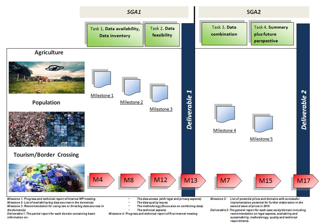
2 WP7 Multi Domains General summary of WP7 work done, Review of the future deliverables and milestones.

 and ONS (Statistics United Kingdom). From SGA-2 (in March 2017) Portugal joined to this team.")
3 WP7 Multi Domains TEAM WP0: CO-ORDINATION WP 1 : Webscraping / Job Vacancies WP 2 : Webscraping / Enterprise Characteristics WP 3 : Smart Meters WP 4 : AIS Data WP 5 : Mobile Phone Data WP 6 : Early Estimates WP 7 : Multi Domains WP 8 : Methodology ESSnet BIG DATA WP9: DISSEMINATION Apart from GUS (Statistics Poland) which is leading WP 7 and CBS (Statistics Netherlands), this WP had been carried out by two other representatives of ESSnet Big Data partners: CSO (Statistics Ireland) and ONS (Statistics United Kingdom). From SGA-2 (in March 2017) Portugal joined to this team. 3

4 Janusz Dygaszewicz Project Manager of Polish work WP7 Multi Domains TEAM Anna Nowicka Leader cooperation Jacek Maślankowski Coordinator of methodology PARTNERS Alessandra Sozzi Nigel Swier, Leone Wardman Regional statistical office in Poznań Regional statistical office in Bydgoszcz Piet Daas Country team for each domain Regional statistical office in Rzeszów Department of Social Research John Sheridan Sinead Bracken Rui Alves Sónia Quaresma Department of Agriculture Regional statistical office in Olsztyn Population Tourism/ border crossing AGRICULTURE


5 Let's introduce ourselves
6 WP7 Multi Domains The aim is to investigate how a combination of big data sources and existing official statistical data can be used to improve current statistics and create new statistics in statistical domains. The work package focusses on the statistical domains : Population, Tourism/border crossings and Agriculture. The work package team will describe the data collection, data linking, data processing and methodological aspects when combining data in statistical domains. Challenges ahead are: representativity issues, linking to other datasets, metadata, international comparability and long lasting solutions with sustainable cost.

7 General summary of WP7 work done


8 Work done - general overview Brainstorming on data sources Questionnaire on different aspects of Big Data implementation e.g., data access, data quality, combining data, methodology Final use cases preparation Several videoconferences Annotated bibliography Pre-Pilot use cases implementation 8
9
10 SGA-2 perspectives Extend the scope of pilot surveys Combining data within domain as well as inter-domain data combination Sharing general framework Under SGA-2 to achieve the main goals, WP7 has started experimental work. For this reason WP7 is planning to carry out the three following case studies. 10
11 POPULATION Everyday citizen satisfaction Responsibility: PL coordinator, supported by UK, PT Data sources: Social media/blogs/internet portals Methodology: Webscraping, Data/Text/Web mining, Machine learning. As the data sources are selective, i.e. only cover units that put text on social media and the internet, the methodology will aim at yielding valid information for the population as a whole. Use will be made of methods described in the literature (such as research on the use of public social media messages done in the Netherlands). The goal of the case study: to examine the level of daily satisfaction of the population by analyzing the content of messages for the presence of defined expressions describing emotional states, e.g., happiness, joy, sadness, fear, anger; to present the moods of the population associated with various public events; to observe morbidity areas, e.g., flu. Plan of Combining Datasets: Combine in one repository the selected data from all Big Data sources, Comparison with the results of social studies to add more detailed information, Supplement of information gained in social studies. Main benefits and value added for official statistics: Support traditional European Social Survey, supplement the research methodology of some phenomena that are difficult to measure through traditional polls.

12 AGRICULTURE Estimation of Agricultural statistics pilot case study on crop types based on satellite data Responsibility: PL coordinator, supported by IE. Data sources: Satellite images, administrative data, in situ surveys. Methodology: combining data data fusion on radar and optical remote sensing data; data comparison with traditional surveys e.g. FSS; combining data administrative data sources with satellite data. The goal of the case study: Crop type: look at the types of crops being grown and see if we can tell this accurately from the imagery; analysis of possibilities of using satellite images. Plan of Combining Datasets: Data fusion combining data sources by spatial reference. Main benefits and value added for official statistics: Increase the quality of the agricultural surveys; Decrease of respondents burden; More detailed data published by official statistics; Potential decrease of the cost of conducting surveys.
13 TOURISM/BORDER CROSSING Border movement Responsibility: PL coordinator, supported by NL and PT. Data sources: Traffic sensors (data already acquired from Polish and German data owners), traditional surveys on tourism, flight statistics such as origin, destination, estimation of number of passengers from Civil Aviation Authority of the Republic of Poland and webscraping. Depending on availability, Mobile Call Data will also be used, building on the results of WP 5. Methodology: spatial-temporal models and graph interpolation methods; cross-entropy econometrics for combining data sets. The goal of the case study: to estimate border traffic through internal border of EU (Polish-German, Polish-Slovakian, Polish-Czech and Polish-Lithuanian border) also regarding to some mirror statistics. Partial estimation of domestic traffic may be an extra result. Selected data sources from national authorities show the scale of border movement that is regarded as tourism in terms of statistical surveys. Plan of Combining Datasets: Unifying structure of data sets; Collecting exogenous variables (road class, etc.); Preparing distance and graph matrices; Quantifying reliability of each data source (expected standard error); Combining traffic data from different sources with cross-entropy econometrics. Main benefits and value added for official statistics: Decreased burden of interviewers, more detailed results than from the survey solely, data consistent with mirror statistics.

14
WP8: Proposal for instructions for conversation with WP-leader
 WP8: Proposal for instructions for conversation with WP-leader Anna Nowicka, WP7, Leader of the Work Package Jacek Maślankowski, WP7, Coordinator of Methodology Start with: 1. List the issues that your
SGA-2: WP6- Early estimates. SURS: Boro Nikić, Tomaž Špeh ESSnet Big Data Project Brussels 26.,
 SGA-2: WP6- Early estimates SURS: Boro Nikić, Tomaž Špeh ESSnet Big Data Project Brussels 26.,27.10. 2017 Outline WP6 state of affairs WP6 pilot: Early estimates of economic indicators Methods Data sources
WP6 Early estimates of economic indicators. WP6 coordinator: Tomaž Špeh, SURS ESSNet Big data: BDES 2018 Sofia 14.,
 WP6 Early estimates of economic indicators WP6 coordinator: Tomaž Špeh, SURS ESSNet Big data: BDES 2018 Sofia 14.,15.5.2018 WP6 objectives Outline Summary of activities carried out and results achieved
APPLYING BIG DATA TOOLS TO ACQUIRE AND PROCESS DATA ON CITIES
 APPLYING BIG DATA TOOLS TO ACQUIRE AND PROCESS DATA ON CITIES JACEK MAŚLANKOWSKI, Ph.D. DEPARTMENT OF BUSINESS INFORMATICS FACULTY OF MANAGEMENT UNIVERSITY OF GDAŃSK, POLAND 1 AGENDA 2 Prerequisites Possible
Common geographies for dissemination of SDG Indicators
 5 th High Level Forum on United Nations GGIM, Mexico 2017 Common geographies for dissemination of SDG Indicators Understanding statistical and geodetic division of territory Janusz Dygaszewicz Central
History & Scope of Remote Sensing FOUNDATIONS
 History & Scope of Remote Sensing FOUNDATIONS Lecture Overview Introduction Overview of visual information Power of imagery Definition What is remote sensing? Definition standard for class History of Remote
Commercialisation. Lessons learned from Dutch weather market
 Commercialisation Lessons learned from Dutch weather market Where information comes together weather traffic public transport Weather, traffic and public transport. Daily actual information that influences
Merging statistics and geospatial information
 Merging statistics and geospatial information Demography / Commuting / Spatial planning / Registers Mirosław Migacz Chief GIS Specialist Janusz Dygaszewicz Director Central Statistical Office of Poland
Rules of the territorial division
 Rules of the territorial division Janusz Dygaszewicz Central Statistical Office of Poland Jerusalem, 4-7 December 2016 Rules of territory division (the Polish case) The area of each unit of territorial
IAEG SDGs WG GI, , Mexico City
 IAEG SDGs WG GI, 12-14.12.2016, Mexico City UN-GGIM:Europe s perspective and activities to support better integration of geospatial information and statistics and the UN SDG monitoring Pier-Giorgio Zaccheddu,
Land Use and Land cover statistics (LUCAS)
") EUROPEAN COMMISSION EUROSTAT Directorate E: Sectoral and regional statistics Doc. ENV/DIMESA/7.1/2012 Original in EN Agenda point 7.1 Land Use and Land cover statistics (LUCAS) DIMESA Directors' Meeting
EUROPEAN COMMISSION EUROSTAT Directorate E: Sectoral and regional statistics Doc. ENV/DIMESA/7.1/2012 Original in EN Agenda point 7.1 Land Use and Land cover statistics (LUCAS) DIMESA Directors' Meeting
I&CLC2000 in support to new policy initiatives (INSPIRE, GMES,..)
") I&CLC2000 in support to new policy initiatives (INSPIRE, GMES,..) Manfred Grasserbauer, Director Joint Research Centre Institute for Environment and Sustainability 1 IMAGE 2000 European mosaic of satellite
I&CLC2000 in support to new policy initiatives (INSPIRE, GMES,..) Manfred Grasserbauer, Director Joint Research Centre Institute for Environment and Sustainability 1 IMAGE 2000 European mosaic of satellite
INSPIRing effort. Peter Parslow Ordnance Survey December Various European approaches to managing an SDI
 INSPIRing effort Peter Parslow Ordnance Survey December 2015 Various European approaches to managing an SDI WHAT IS INSPIRE? A European Union Directive A community effort: http://inspire.ec.europa.eu/
Work Packages. RECROS Project development workshop. Prague, 30 th April 2015
 Work Packages Prague, 30 th April 2015 Main principles - remarks Protected areas, regions, cities, not only comparison cities/rural areas HU most of cities have their climate strategies good contacts to
A Broad View of Geospatial Technology & Systems
 A Broad View of Geospatial Technology & Systems Pete Large Vice President, Trimble On the shoulders of giants 1 Since their time, our ability to generate geospatial information has grown exponentially
FLYSAFE Bird strike risk mitigation in aviation
 FLYSAFE Bird strike risk mitigation in aviation Arie Dekker Command Mission Support Branche Nature Bureau Serge Sorbi Belgian Air Force Aviation Safety Directorate Wildlife Hazard Management Integrated
Compact guides GISCO. Geographic information system of the Commission
 Compact guides GISCO Geographic information system of the Commission What is GISCO? GISCO, the Geographic Information System of the COmmission, is a permanent service of Eurostat that fulfils the requirements
The Safeland Project General Overview and Monitoring Technology Development
 Ber. Geol. B. A., 82, ISSN 1017 8880 Landslide Monitoring Technologies & Early Warning Systems The Safeland Project General Overview and Monitoring Technology Development The SafeLand Consortium a), N.
E-Learning with EuroSDR. Arpad Barsi BME Dept. of Photogrammetry and Geoinformatics
 E-Learning with EuroSDR Arpad Barsi BME Dept. of Photogrammetry and Geoinformatics Motto and goal Learning by doing Distance learning courses for EU and non-eu country students with a short introduction
SCENT: A Smart Toolbox for Engaging Citizens into a People Centric Observation Web. INSPIRE 2016 Conference Barcelona, 28 September 2016
 SCENT: A Smart Toolbox for Engaging Citizens into a People Centric Observation Web INSPIRE 2016 Conference Barcelona, 28 September 2016 Summary SCENT Facts & figures Motivation SCENT @ a glance SCENT objectives
OUR 2016 BIG STORIES F R O M R U R A L C O M M U N I T I E S F O L L O W T H E M O N E Y N G.
 OUR 2016 BIG STORIES F R O M R U R A L C O M M U N I T I E S F O L L O W T H E M O N E Y N G. O R G STORIES F R O M C O M M U N I T I E S I n N i g e r i a n r u r a l c o m m u n i t i e s, o v e r t
SPLAN-Natura Towards an integrated spatial planning approach for Natura th January, 2017 Brussels. Commissioned by DG Environment
 SPLAN-Natura 2000 Towards an integrated spatial planning approach for Natura 2000 Commissioned by DG Environment 17 th January, 2017 Brussels V. Simeonova (Ph.D.) Drivers towards integrating Biodiversity
Prof. Dr. Leo Gros. Europa Fachhochschule Fresenius
 Prof. Dr. Leo Gros Vice President Europa Fachhochschule Fresenius University of Applied Sciences Idstein, Germany 0049-6126-9352-60 gros@fh-fresenius.de 1 COMENIUS 2.1. Project CITIES CITIES - Chemistry
ArcGIS for INSPIRE. Marten Hogeweg Satish Sankaran
 ArcGIS for INSPIRE Marten Hogeweg Satish Sankaran Outline What is ArcGIS ArcGIS for INSPIRE Web GIS Case Studies Roadmap Q&A What is INSPIRE? INSPIRE is the legal framework for a European Spatial Data
Plan4all (econtentplus project)
") Plan4all (econtentplus project) Karel CHARVAT 1, Tomáš MILDORF 2 1 Help service remote sensing, Ltd., Černoleská 1600, 256 01 Benešov u Prahy, Czech Republic charvat@bnhelp.cz 2 Department of Mathematics
Plan4all (econtentplus project) Karel CHARVAT 1, Tomáš MILDORF 2 1 Help service remote sensing, Ltd., Černoleská 1600, 256 01 Benešov u Prahy, Czech Republic charvat@bnhelp.cz 2 Department of Mathematics
Part : General Situation of Surveying and Mapping. The Development of Surveying and Mapping in China. The contents
 The Development of Surveying and Mapping in China Dr. Ping Xiao China.P.R The contents Part : General Situation of Surveying and Mapping 1. The legal systems of surveying and mapping 2. The technologies
Principle 3: Common geographies for dissemination of statistics Poland & Canada. Janusz Dygaszewicz Statistics Poland
 Principle 3: Common geographies for dissemination of statistics Poland & Canada Janusz Dygaszewicz Statistics Poland Reference materials Primary: Ortophotomap, Cadastral Data, Administrative division borders,
Building a National Data Repository
 Building a National Data Repository Mladen Stojic, Vice President - Geospatial 1/30/2013 2012 Intergraph Corporation 1 Information has meaning and gives power only when shared and distributed. Information,
EO4SEE - THE PATHFINDER OF OPERATIONAL SATELLITE MONITORING FOR THE REGION OF THE BLACK SEA AND CENTRAL EUROPE
 EO4SEE: Pathfinder assessment for regional high volume data access, processing and information service delivery platforms - South East Region EO4SEE - THE PATHFINDER OF OPERATIONAL SATELLITE MONITORING
Comparative Analysis of Regional Tourism Policy in Slovakia and Austria
 2 nd Central European Conference in Regional Science CERS, 2007 474 Comparative Analysis of Regional Tourism Policy in and Jana KUČEROVÁ, Tomáš MAKOVNÍK Department of Tourism and Hospitality Faculty of
Leveraging Sentinel-1 time-series data for mapping agricultural land cover and land use in the tropics
 Leveraging Sentinel-1 time-series data for mapping agricultural land cover and land use in the tropics Caitlin Kontgis caitlin@descarteslabs.com @caitlinkontgis Descartes Labs Overview What is Descartes
3-D View on Training in Aeronautical Meteorology (University, Trainer, Student Perspectives)
") 3-D View on Training in Aeronautical Meteorology (University, Trainer, Student Perspectives) University Maria MAMAEVA (RSHU) Trainer Paul BUGEAC (ROMATSA) Student Ekaterina CHUMAK (RSHU) 3-D View: Aeronautical
3-D View on Training in Aeronautical Meteorology (University, Trainer, Student Perspectives) University Maria MAMAEVA (RSHU) Trainer Paul BUGEAC (ROMATSA) Student Ekaterina CHUMAK (RSHU) 3-D View: Aeronautical
The Combination of Geospatial Data with Statistical Data for SDG Indicators
 Session x: Sustainable Development Goals, SDG indicators The Combination of Geospatial Data with Statistical Data for SDG Indicators Pier-Giorgio Zaccheddu Fabio Volpe 5-8 December2018, Nairobi IAEG SDG
The National Spatial Strategy
 Purpose of this Consultation Paper This paper seeks the views of a wide range of bodies, interests and members of the public on the issues which the National Spatial Strategy should address. These views
Oak Ridge Urban Dynamics Institute
 Oak Ridge Urban Dynamics Institute Presented to ORNL NEED Workshop Budhendra Bhaduri, Director Corporate Research Fellow July 30, 2014 Oak Ridge, TN Our societal challenges and solutions are often local
Switching to AQA from Edexcel: Draft Geography AS and A-level (teaching from September 2016)
") Switching to AQA from Edexcel: Draft Geography AS and A-level (teaching from September 2016) If you are thinking of switching from OCR to AQA (from September 2016), this resource is an easy reference guide.
Switching to AQA from Edexcel: Draft Geography AS and A-level (teaching from September 2016) If you are thinking of switching from OCR to AQA (from September 2016), this resource is an easy reference guide.
The National Spatial Data Infrastructure of Zambia Shlomi SIVAN, Israel. Key words: National Land Audit, GIS, LIS, Common Spatial Data
 The National Spatial Data Infrastructure of Zambia Shlomi SIVAN, Israel Key words: National Land Audit, GIS, LIS, Common Spatial Data SUMMARY One of Zambia's important challenges is to recognize the title
baltrad Mass media Overview
 48 Mass media Overview Weather information disseminated through mass media, like press, TV, and Internet is intended for its recipients, not for the media themselves. Therefore the addressees of the media
INSPIRE - A Legal framework for environmental and land administration data in Europe
 INSPIRE - A Legal framework for environmental and land administration data in Europe Dr. Markus Seifert Bavarian Administration for Surveying and Cadastre Head of the SDI Office Bavaria Delegate of Germany
Welcome. C o n n e c t i n g
 Welcome C o n n e c t i n g YOU D i s c i p l i n e s Why is This Meeting......So Important Now? OUR WORLD Is Increasingly Challenged The Evidence Is Clear We Need Better Understanding and More Collaboration
XXIII CONGRESS OF ISPRS RESOLUTIONS
 XXIII CONGRESS OF ISPRS RESOLUTIONS General Resolutions Resolution 0: Thanks to the Czech Society commends: To congratulate The Czech Society, its president and the Congress Director Lena Halounová, the
Online Appendix for Cultural Biases in Economic Exchange? Luigi Guiso Paola Sapienza Luigi Zingales
 Online Appendix for Cultural Biases in Economic Exchange? Luigi Guiso Paola Sapienza Luigi Zingales 1 Table A.1 The Eurobarometer Surveys The Eurobarometer surveys are the products of a unique program
GIS FOR MAZOWSZE REGION - GENERAL OUTLINE
 GIS FOR MAZOWSZE REGION - GENERAL OUTLINE S. Bialousz 1), K Mączewski 2), E. Janczar 2), K. Osinska-Skotak 1) 1) Warsaw University of Technology, Warsaw, Poland 2) Office of the Surveyor of the Mazowieckie
GeoERA Raw Materials Mineral Intelligence for Europe (MINTELL4EU)
") GeoERA Raw Materials Mineral Intelligence for Europe (MINTELL4EU) Improving and sustaining the EURMKB Pedro Delgado Department of Geological Resources Research GEOLOGICAL SURVEY OF SPAIN Horizon 2020 Co-funded
GeoERA Raw Materials Mineral Intelligence for Europe (MINTELL4EU) Improving and sustaining the EURMKB Pedro Delgado Department of Geological Resources Research GEOLOGICAL SURVEY OF SPAIN Horizon 2020 Co-funded
WMO. Key Elements of PWS and Effective EWS. Haleh Haleh Kootval Chief, PWS Programme
 WMO Key Elements of PWS and Effective EWS Haleh Haleh Kootval Chief, PWS Programme Workshop Objectives This workshop is all about Service Delivery and becoming excellent at it through: Sharing experiences
European Spatial Data Research. EuroSDR. Prof. Dr. Ir. Joep Crompvoets. General Assembly CLGE Tirana 18 March
 EuroSDR Prof. Dr. Ir. Joep Crompvoets General Assembly CLGE - 2016 Tirana 18 March 2016 INTRODUCTORY QUESTIONS Who knows what is EuroSDR? Who does NOT know what is EuroSDR? Who is employed at mapping agencies?
Jay Lawrimore NOAA National Climatic Data Center 9 October 2013
 Jay Lawrimore NOAA National Climatic Data Center 9 October 2013 Daily data GHCN-Daily as the GSN Archive Monthly data GHCN-Monthly and CLIMAT messages International Surface Temperature Initiative Global
The Joint Programming Initiative on Cultural Heritage (JPICH): European perspective
: European perspective") COPERNICUS FOR CULTURAL HERITAGE Copernicus User Forum Industry Workshop Brussels, 24 April 2017 The Joint Programming Initiative on Cultural Heritage (JPICH): European perspective Cristina Sabbioni CNR,
COPERNICUS FOR CULTURAL HERITAGE Copernicus User Forum Industry Workshop Brussels, 24 April 2017 The Joint Programming Initiative on Cultural Heritage (JPICH): European perspective Cristina Sabbioni CNR,
IRTS 2008 Compilation Guide: an overview
 IRTS 2008 Compilation Guide: an overview Content: The process The provisional organization of the content of the compilation guide Major highlights The process It was initiated as soon as the IRTS 2008
Next steps: what national and international statistical offices can do to improve our measures
 Next steps: what national and international statistical offices can do to improve our measures Walter Radermacher President of the Federal Statistical Office, Germany Conference Beyond GDP 19-20 November
40 Years Listening to the Beat of the Earth
 EuroGeoSurveys The role of EuroGeoSurveys in Europe-Africa geoscientific cooperation 40 Years Listening to the Beat of the Earth EuroGeoSurveys 32 Albania Lithuania Austria Luxembourg Belgium The Netherlands
VGIscience Summer School Interpretation, Visualisation and Social Computing of Volunteered Geographic Information (VGI)
") VGIscience Summer School Interpretation, Visualisation and Social Computing of Volunteered Geographic Information (VGI) TU Dresden, 11.-15. September 2017 Welcome PhD students working on research topics
VGIscience Summer School Interpretation, Visualisation and Social Computing of Volunteered Geographic Information (VGI) TU Dresden, 11.-15. September 2017 Welcome PhD students working on research topics
INSPIREd solutions for Air Quality problems Alexander Kotsev
 INSPIREd solutions for Air Quality problems Alexander Kotsev www.jrc.ec.europa.eu Serving society Stimulating innovation Supporting legislation The European data puzzle The European data puzzle 24 official
Update on CITIES. Chemistry and Industry for Teachers in European Schools LEO GROS
 Update on CITIES Chemistry and Industry for Teachers in European Schools LEO GROS EMCEF-ECEG Social Dialogue Committee WG Education, Training, Lifelong Learning Brussels Feb. 29th, 28 EMCEF-ECEG 29.2.8
Disaster Management & Recovery Framework: The Surveyors Response
 Disaster Management & Recovery Framework: The Surveyors Response Greg Scott Inter-Regional Advisor Global Geospatial Information Management United Nations Statistics Division Department of Economic and
Geographical Information Systems Energy Database Report. WP1 T1.3- Deliverable 1.9
 Geographical Information Systems Energy Database Report WP1 T1.3- Deliverable 1.9 March 2015 1 314164 (ENER/FP7/314164) Project acronym: InSMART Project full title: Integrative Smart City Planning Coordination
INCA-CE: The Challenge of Severe Weather Warnings. Yong Wang, ZAMG
 INCA-CE: The Challenge of Severe Weather Warnings Yong Wang, ZAMG Severe Weather and Impact The need of civil society and economy Save Life! Save Cost! Reduce Risks and impacts! The Challenge of Severe
Economic and Social Council 2 July 2015
 ADVANCE UNEDITED VERSION UNITED NATIONS E/C.20/2015/11/Add.1 Economic and Social Council 2 July 2015 Committee of Experts on Global Geospatial Information Management Fifth session New York, 5-7 August
Voices from Private Sector: Insights for Future NSDI Development in Indonesia
 Voices from Private Sector: Insights for Future NSDI Development in Indonesia Ta n d a n g Yu l i a d i D w i P u t ra, Ryosuke S h i b a s a k i I n st i t u t e o f I n d u st r i a l S c i e n c e,
The Socio Economic Development of the Marine Sector in the Atlantic Area. Stephen Hynes
 The Socio Economic Development of the Marine Sector in the Atlantic Area Stephen Hynes Overview SEMRU and its role in Marine Socioeconomic analysis Defining Ocean and Coastal Economies in the Atlantic
Data Collection. Lecture Notes in Transportation Systems Engineering. Prof. Tom V. Mathew. 1 Overview 1
 Data Collection Lecture Notes in Transportation Systems Engineering Prof. Tom V. Mathew Contents 1 Overview 1 2 Survey design 2 2.1 Information needed................................. 2 2.2 Study area.....................................
3D Urban Information Models in making a smart city the i-scope project case study
 UDC: 007:528.9]:004; 007:912]:004; 004.92 DOI: 10.14438/gn.2014.17 Typology: 1.04 Professional Article 3D Urban Information Models in making a smart city the i-scope project case study Dragutin PROTIĆ
Georeferencing and Satellite Image Support: Lessons learned, Challenges and Opportunities
 Georeferencing and Satellite Image Support: Lessons learned, Challenges and Opportunities Shirish Ravan shirish.ravan@unoosa.org UN-SPIDER United Nations Office for Outer Space Affairs (UNOOSA) UN-SPIDER
The Combination of Geospatial Data with Statistical Data for SDG Indicators
 Session 3: Sustainable Development Goals, SDG indicators The Combination of Geospatial Data with Statistical Data for SDG Indicators Pier-Giorgio Zaccheddu (with the assistance of Francisco Vala & Cátia
Foreword. The new Programme of Work for 2010 / 2011 identifies those actions that will concentrate most of the financial resources assigned to it:
 Foreword As a new publication at the time, the Enzo Paci Papers was conceived to serve as a platform for the familiarization of tourism statisticians and economic analysts with the UNWTO work in these
A route map to calibrate spatial interaction models from GPS movement data
 A route map to calibrate spatial interaction models from GPS movement data K. Sila-Nowicka 1, A.S. Fotheringham 2 1 Urban Big Data Centre School of Political and Social Sciences University of Glasgow Lilybank
The Kentucky Mesonet: Entering a New Phase
 The Kentucky Mesonet: Entering a New Phase Stuart A. Foster State Climatologist Kentucky Climate Center Western Kentucky University KCJEA Winter Conference Lexington, Kentucky February 9, 2017 Kentucky
Historical Assessment of Spatial Growth of Built-ups and Metropolitan areas of Delhi and Mumbai in India and Dhaka in Bangladesh
 Historical Assessment of Spatial Growth of Built-ups and Metropolitan areas of Delhi and Mumbai in India and Dhaka in Bangladesh Tomas Soukup, GISAT World Bank HQ, Washington DC Date : 12 April 2011 Introduction
The Global Statistical Geospatial Framework. Martin Brady Director Geospatial Solutions Australian Bureau of Statistics Australia
 The Global Statistical Geospatial Framework Martin Brady Director Geospatial Solutions Australian Bureau of Statistics Australia Outline 1. Origins of the Global Statistical Geospatial Framework 2. Global
Call for Applications
 Call for Applications for a PanAfGeo Training «WP1 Geoscientific Mapping, part WP1E1 Remote Sensing» 20-30 November 2017, Bishoftu, Ethiopia in English 1. MAIN CONTEXT OF PANAFGEO PanAfGeo for Pan-African
Towards a City Model for Heritage-Led Regeneration and Tourism Development
 Towards a City Model for Heritage-Led Regeneration and Tourism Development Brian Smith, Secretary General European Association of Historic Towns and Regions Summary of Presentation Objective Background
Sustainable and Harmonised Development for Smart Cities The Role of Geospatial Reference Data. Peter Creuzer
 Sustainable and Harmonised Development for Smart Cities The Role of Geospatial Reference Data Peter Creuzer 1. Introduction - Smart Cities and Geodata 2. Geodata in Germany 3. Examples 4. Data and Service
Exploring the Patterns of Human Mobility Using Heterogeneous Traffic Trajectory Data
 Exploring the Patterns of Human Mobility Using Heterogeneous Traffic Trajectory Data Jinzhong Wang April 13, 2016 The UBD Group Mobile and Social Computing Laboratory School of Software, Dalian University
United States Multi-Hazard Early Warning System
 United States Multi-Hazard Early Warning System Saving Lives Through Partnership Lynn Maximuk National Weather Service Director, Central Region Kansas City, Missouri America s s Weather Enterprise: Protecting
Variance estimation on SILC based indicators
 Variance estimation on SILC based indicators Emilio Di Meglio Eurostat emilio.di-meglio@ec.europa.eu Guillaume Osier STATEC guillaume.osier@statec.etat.lu 3rd EU-LFS/EU-SILC European User Conference 1
GEOGRAPHIC INFORMATION SYSTEMS Session 8
 GEOGRAPHIC INFORMATION SYSTEMS Session 8 Introduction Geography underpins all activities associated with a census Census geography is essential to plan and manage fieldwork as well as to report results
The European Forum for Geospatial Statistics Benefits and challenges of INSPIRE in the field of statistics
 INSPIRE Conference 2016 Barcelona, Spain 26th 30th September 2016 The European Forum for Geospatial Statistics Benefits and challenges of INSPIRE in the field of statistics Janusz Dygaszewicz EFGS President
Chapter 1: Overview of Environment Statistics Characteristics and Challenges
 Chapter 1: Overview of Environment Statistics Characteristics and Challenges Workshop on Environment Statistics in support of the implementation of the Framework for the Development of Environment Statistics
Moroccan lightning detection network, topology, performance and management of the network
 Moroccan lightning detection network, topology, performance and management of the network Mohamed DAHOUI, Mohamed NBOU and Rabia MERROUCHI Moroccan Meteorological Center Tel (212)71302837, Fax: (212)22908593
The use of satellite images to forecast agricultural production
 The use of satellite images to forecast agricultural production Artur Łączyński Central Statistical Office, Agriculture Department Niepodległości 208 Warsaw, Poland E-mail a.laczynski@stat.gov.pl DOI:
ACCESSIBILITY TO SERVICES IN REGIONS AND CITIES: MEASURES AND POLICIES NOTE FOR THE WPTI WORKSHOP, 18 JUNE 2013
 ACCESSIBILITY TO SERVICES IN REGIONS AND CITIES: MEASURES AND POLICIES NOTE FOR THE WPTI WORKSHOP, 18 JUNE 2013 1. Significant differences in the access to basic and advanced services, such as transport,
GIS Building Communities beyond National Borders (Building Successful Spatial Data Infrastructures) Nick Land, ESRI Europe
 Nick Land, ESRI Europe") GIS Building Communities beyond National Borders (Building Successful Spatial Data Infrastructures) Nick Land, ESRI Europe UK worst flooding in the last 60 years 350,000 households without drinking water
GIS Building Communities beyond National Borders (Building Successful Spatial Data Infrastructures) Nick Land, ESRI Europe UK worst flooding in the last 60 years 350,000 households without drinking water
Finding Poverty in Satellite Images
 Finding Poverty in Satellite Images Neal Jean Stanford University Department of Electrical Engineering nealjean@stanford.edu Rachel Luo Stanford University Department of Electrical Engineering rsluo@stanford.edu
COSMIC: COmplexity in Spatial dynamic
 COSMIC: COmplexity in Spatial dynamic MICs 9 10 November, Brussels Michael Batty University College London m.batty@ucl.ac.uk http://www.casa.ucl.ac.uk/ Outline The Focus of the Pilot The Partners: VU,
Further information: Basic principles of quantum computing Information on development areas of Volkswagen Group IT
 Media information Further information: Basic principles of quantum computing Information on development areas of Volkswagen Group IT Basic principles of quantum computing Development areas of Volkswagen
Spanish national plan for land observation: new collaborative production system in Europe
 ADVANCE UNEDITED VERSION UNITED NATIONS E/CONF.103/5/Add.1 Economic and Social Affairs 9 July 2013 Tenth United Nations Regional Cartographic Conference for the Americas New York, 19-23, August 2013 Item
CONFERENCE STATEMENT
 CONFERENCE STATEMENT We, the elected representatives from Canada, Denmark/Greenland, Finland, Iceland, Norway, Russia, Sweden and the United States of America; In collaboration with the indigenous peoples
Contract title: Technical assistance for multi-annual programming of future cross border cooperation programme in the Romania-Serbia cooperation area
 GOVERNMENT OF ROMANIA SERBIAN GOVERNMENT Contract title: Technical assistance for multi-annual programming of future cross border cooperation programme in the Romania-Serbia cooperation area Reference:
SIRWEC 2012 Helsinki, March Finland. Miroslav Škuthan Central Forecasting Office Czech Hydrometeorological Institute
 ID: 0069 CHMI Standing International Road Weather Commission Helsinki, 23-25 March Finland Miroslav Škuthan Central Forecasting Office Czech Hydrometeorological Institute Road Weather Data Presentation
The Danish Maritime Spatial Data Infrastructure (MSDI) Geodata of the Sea
 Geodata of the Sea") MSDI/MSP The Danish Maritime Spatial Data Infrastructure (MSDI) Geodata of the Sea Components of an infrastructure: DATA - metadata, datasets FUNCTIONALITY - spatial data services, web services and other
MSDI/MSP The Danish Maritime Spatial Data Infrastructure (MSDI) Geodata of the Sea Components of an infrastructure: DATA - metadata, datasets FUNCTIONALITY - spatial data services, web services and other
Open Data meets Big Data
 Open Data meets Big Data Max Craglia, Sven Schade, Anders Friis European Commission Joint Research Centre www.jrc.ec.europa.eu Serving society Stimulating innovation Supporting legislation JRC is Technical
1 Introduction. Station Type No. Synoptic/GTS 17 Principal 172 Ordinary 546 Precipitation
 Use of Automatic Weather Stations in Ethiopia Dula Shanko National Meteorological Agency(NMA), Addis Ababa, Ethiopia Phone: +251116639662, Mob +251911208024 Fax +251116625292, Email: Du_shanko@yahoo.com
Geographical Collections in Greek Academic Libraries: current situation and perspectives
 Ionian University Department of Archives and Library Science Laboratory on Digital Libraries and Electronic Publishing Geographical Collections in Greek Academic Libraries: current situation and perspectives
econtentplus GS Soil
 econtentplus GS Soil General aims Assessment and strategic development of INSPIRE compliant Geodata-Services for European Soil Data BPN on basis of the EU 2007/2/EC (INSPIRE) Directive for Annex III theme
INTAROS Integration of the existing Arctic observing systems into a common data frame. Roberta Pirazzini, Finnish Meteorological Institute
 INTAROS Integration of the existing Arctic observing systems into a common data frame Roberta Pirazzini, Finnish Meteorological Institute Outline 1. Overview of the INTAROS project 2. Overview of the INTAROS
New EU efforts to assess the state of the marine environment: the EMODnet Chemistry pilot project
 New EU efforts to assess the state of the marine environment: the EMODnet Chemistry pilot project Matteo Vinci and Alessandra Giorgetti, OGS NODC group, OCE September 2013 - IMDIS 2013, Lucca Overview
INSPIRE in the context of EC Directive 2002/49/EC on Environmental Noise
 INSPIRE in the context of EC Directive 2002/49/EC on Environmental Noise Simon Shilton Acustica Ltd, United Kingdom Nigel Jones Extrium Ltd, United Kingdom About the Authors www.acustica.co.uk Acoustics
Implementation of the Political Declaration on energy cooperation between the North Seas Countries. Support Group 1 on Maritime Spatial Planning
 Implementation of the Political Declaration on energy cooperation between the North Seas Countries Support Group 1 on Maritime Spatial Planning Work Programme 1. Work area as outlined in Annex I to the
SDG s and the role of Earth Observation
 SDG s and the role of Earth Observation Christian Heipke IPI - Institute for Photogrammetry and GeoInformation Leibniz Universität Hannover Germany Secretary General, ISPRS 1. No Poverty 2. Zero Hunger
Christina Karaberi- Msc Health Management European Program Manager ITR. CityMobil2 Reference Group Meeting, Antibes, France 22/03/206
 TRIKALA DEMONSTRATION TITLE A CTS SITE- FOR Large THE Scale PerspectiveNEW ROME EXHIBITION Christina Karaberi- Msc Health Management European Program Manager E-Trikala Gabriele S.A Giustiniani, ITR 22/03/206