FLYSAFE Bird strike risk mitigation in aviation
|
|
|
- Jade Newton
- 5 years ago
- Views:
Transcription


1 FLYSAFE Bird strike risk mitigation in aviation Arie Dekker Command Mission Support Branche Nature Bureau Serge Sorbi Belgian Air Force Aviation Safety Directorate Wildlife Hazard Management Integrated Applications Promotion (IAP) initiative


2 Arie Dekker Command Mission Support Branche, Nature Bureau
3 Presentation overview Bird strikes the problem, on airfield<->en-route, civil<->military Prevention on airfield<->en-route, radar detection FlySafe project common user requirements bird mobility, prediction Follow-on Pre-operational service centre, FlySafe-2 3
4 4


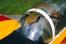
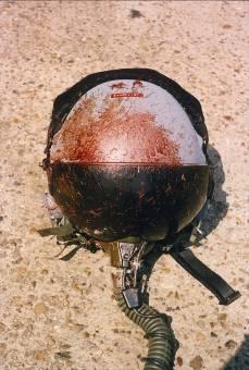
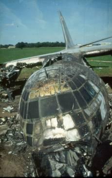
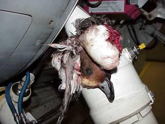
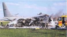
5 Effects of bird strikes: RNLAF 2004/2006, N=164 Loss of mission time Aborted take-off 10 Precautionary landing 27 Returned to base 50 Damage to aircraft 15% of BS result in damage Aircraft grounded from 1 hour to 91 days Loss of aircraft 1 F-16 5
6 The nature of bird strikes Bird strikes with jet fighter aircraft over speed EURBASE N-17,732 35% 30% 25% Fraction (%) 20% 15% 10% 5% 0% >550 Speed (kts) 6
7 The nature of bird strikes Bird strikes with jet fighter aircraft over speed EURBASE N-17,732 35% 30% En-route (71.9%) Local (28.1%) 25% Fraction (%) 20% 15% 10% 5% 0% >550 Speed (kts) 7
8 The nature of bird strikes Bird strikes with jet fighter aircraft over speed EURBASE N-17,732 35% 30% En-route (71.9%) Local (28.1%) 25% Fraction (%) 20% 15% 10% 5% 0% >550 Speed (kts) 8
9 Bird Strike Prevention On-airfield, keep birds away from aircraft by habitat management active harassment Civil en-route: Aircraft fly above birds, not relevant Military en-route, keep aircraft away from birds radar detection of high bird intensities operational restraint 9


10 Existing radar knowledge / experience: the starting point for FlySafe 10 cm pulse Single bird 65 Km Flock 120/150 Km Time laps film October 1980 Dawn effect Electronic extraction of bird echoes by ROBIN system 10


11 BIRDTAM used by pilots in operational environment 11
 Initiative")


12 Integrated Applications Promotion (IAP) Initiative Focus on bird mobility in relation to: Human + Livestock Health Avian borne diseases Migration Ecology Scientific interest Conservation + Education Hotspots + Flyways Flight Safety Bird Strike Problem 12
13 FlySafe project partners 13
14 The FlySafe project as an opportunity Offering a birds eye view from space, including: Connection of international expert communities Experience in a multi user and multi discipline approach Combining technologies in complex integrated systems Satellite information on bird mobility, enabling forecast modeling Remote sensing data (weather and landscape) essential for forecast modeling Convincing by showing ESA as an honest broker -> trustworthy for all partners! 14

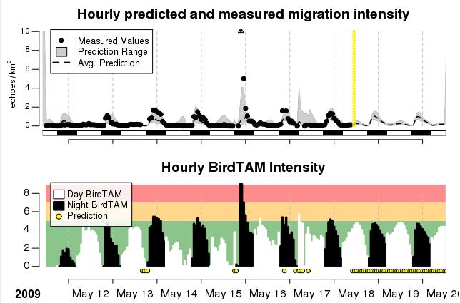
15 FlySafe project activities Getting to know what is needed User driven approach Define user requirements that are agreed by all parties Define project set-up 15


16 FlySafe project activities Data management Central database for information from ALL sources Dissemination and storage of individual bird tracks from 2 MPR radars Website, including visualisation tools 16

 MPR radar history")

17 FlySafe project activities Development of automatic 24/7 prediction models 4 locations (2 B + 2 NL) MPR radar history weather data earth observation GPS logging of individual birds 17


18 FlySafe project activities Develop algorithms for weather radars 4 radars (2 B + 2 NL + 1 F) parallel observation series Swiss research radar 18


19 FlySafe project activities Trial of on-airfield avian radar (ROBIN Lite) prevention of local bird strikes 2 D radar on 1 airbase 19


20 Role of space Satcom for Sensors Remote Locations Birds with Backpack GPS-ARGOS Weather & Land Cover EUMETSAT 20 LandSAT (MSS,TM)

21 FlySafe System Set-up 21
22 FlySafe results General: Better co-ordination between D/B/NL Interdisciplinary co-operation that created added value Services for BAF + RNLAF Bird mobility forecasts for 4 locations Automatic extraction of bird information from weather radars For on airfield situation: Potential of small bird radars as last line of defence 22
23 For 4 locations (2B+2NL) Prediction (dotted line) +margin (shadow) Measurements (black dots) Missing radardata (triangles) Translation to BIRDTAM values 23
24 24
 Altitude")
25 25 2 NL weather radars Density (colours) Altitude (Y axis)


26 FlySafe results and project use by RNLAF Creation of BIRDTAMS: More objective, more reliable Safer with less operational restraint Daily use of: The models The MPR radars The weather radars 26
27 FlySafe follow-on (military aviation) Pre-operational services hosted by KNMI (2011): Sustainable within existing cooperation between Air Force and KNMI 24/7 automatic running of models 2 B + 2 NL locations 24/7 automatic extraction from weather radars 3 B + 2 NL locations FlySafe-2 ( ): Building upon FlySafe-1, RNLAF funded additional time-based modelling using weather radar new modelling of altitude based on weather radar addition of >6 weather radars in neighbouring countries teaming up with EU Lifewatch program 27


28 FlySafe project use and operational impact for Belgian Air Force flying activity Serge Sorbi (BAF)

29 Belgian Air Force Birdstrike prevention en route Giving information to pilots so that they can avoid high bird density zone.

30 BIRDTAM Information is transmitted by specific message : BIRDTAM BIRDTAM also broadcasted via the pilot s meteorological support software. - Georef square - Bird Intensity - Altitude - Validity period


31 FlySafe project improvement Necessity of harmonization of BIRDTAM broadcasted by different countries for a common georef square. B NL GE International NOTAM Database Traben trarbach


32 FlySafe project improvement Better altitude information by use of meteo radar.

33 BIRDTAM impact on flying operations Due to BIRDTAM, the flying operations can be limited (BIRDTAM 5) or even totally cancelled (BIRDTAM = 8). It has a direct operational impact on the flying program and can have a financial impact for BAF - during bird migration period. - during night flight period.

34 Bird migration above Belgium BE
 Bird tracks Radar location Ground clutter Belgian")
35 Bird migration above Belgium MPR radar = Robin picture (100 sec) Bird tracks Radar location Ground clutter Belgian border


36 Bird migration above Belgium 08 march z 08 march z 08 march z D U S K 08 march z 08 march z 08 march z
37 Impact of bird migration on F-16 night flight operation 2 F-16 airbases activated 1 diversion airbase activated pm Night Flight cancelled => 3 airbases on duty pm BIRDTAM 30 % of night flights affected by BIRDTAM pm aircraft take-off pm Dusk pm End of daily flying window Mission preparation


38 Impact of lack of forecast in case of night flights cancellation. Services on duty : Stand-by for nothing! Flight planning disturbed, time & money lost

39 BIRDTAM forecast «For AF s, a way to save money» Better planning of flying activity. In case of BIRDTAM 8 forecast : cancellation of night flights 48 hrs forward

40 BIRDTAM forecast «For AF s, a way to save money» Belgian BIRDTAM forecast developed in the framework of the FlySafe Project Better flight planning, better time and human resources management => money saved
41 QUESTIONS?
The FlySafe project: How weather radars can improve the en-route bird strike warning system.
 The FlySafe project: How weather radars can improve the en-route bird strike warning system. Hans van Gasteren 1,2, Arie Dekker 2, Judy Shamoun-Baranes 1, Hidde Leijnse 3, Michael Kemp 1, Martin de Graaf
Combining radar systems to get a 3D - picture of the bird migration Liechti, F.; Dokter, A.; Shamoun-Baranes, J.Z.; van Gasteren, J.R.; Holleman, I.
 UvA-DARE (Digital Academic Repository) Combining radar systems to get a 3D - picture of the bird migration Liechti, F.; Dokter, A.; Shamoun-Baranes, J.Z.; van Gasteren, J.R.; Holleman, I. Published in:
The current status, functions, challenges and needs of South Sudan Meteorological Department (SSMD)
") The current status, functions, challenges and needs of South Sudan Meteorological Department (SSMD) Presented: by Mojwok Ogawi Modo, South Sudan Meteorological Department. Background The present SSMD was
The current status, functions, challenges and needs of South Sudan Meteorological Department (SSMD) Presented: by Mojwok Ogawi Modo, South Sudan Meteorological Department. Background The present SSMD was
Bird detection by operational weather radar
 Bird detection by operational weather radar Adriaan M. Dokter 1,2, Felix Liechti 3, Laurent Delobbe 4, Pierre Tabary 5, Hans Beekhuis 6 and Iwan Holleman 2 1 Institute for Biodiversity and Ecosystem Dynamics,
Opportunities and Risks National Responses Austria Aeronautical MET Services -Part of an ATC Provider
 Opportunities and Risks National Responses Austria Aeronautical MET Services -Part of an ATC Provider AUSTRO CONTROL is the former Federal Office of Civil Aviation. is a company with limited liability.
INTERNATIONAL BIRD STRIKE COMMITTEE Amsterdam, April 2000
 INTERNATIONAL BIRD STRIKE COMMITTEE IBSC25/WP-RS5 Amsterdam, 17-21 April 2000 THE AVIAN HAZARD ADVISORY SYSTEM (AHAS): OPERATIONAL USE OF WEATHER RADAR FOR REDUCING BIRD STRIKE RISK IN NORTH AMERICA. T
Mode-S EHS data usage in the meteorological domain:
 Mode-S EHS data usage in the meteorological domain: derivation of Wind and Temperature observations; and assimilation of these observations in a numerical weather prediction model. Jan Sondij, MBA Senior
Weather Information for Europe 3 May 2018
 Weather Information for Europe 3 May 2018 Weatherproofing the network A collaborative approach Jaakko Nuottokari EUMETNET WG AVIMET Chair Head of Aviation and Defence Finnish Meteorological Institute Jaakko.Nuottokari@fmi.fi
Monitoring bird migration by weather radar
 Monitoring bird migration by weather radar Adriaan Dokter and Iwan Holleman Introduction Weather and bird migration are intimately related. Evolution has shaped the migration strategies of birds such that
Airport Wildlife Strike Hazard Management
 Airport Wildlife Strike Hazard Management November 2005 Program Review Edwin E. Herricks University of Illinois Center of Excellence and FAA WSM-R (AAR 411) From: FAA Flight Plan 2004-2008 The FAA will
CLIMATE CHANGE ADAPTATION BY MEANS OF PUBLIC PRIVATE PARTNERSHIP TO ESTABLISH EARLY WARNING SYSTEM
 CLIMATE CHANGE ADAPTATION BY MEANS OF PUBLIC PRIVATE PARTNERSHIP TO ESTABLISH EARLY WARNING SYSTEM By: Dr Mamadou Lamine BAH, National Director Direction Nationale de la Meteorologie (DNM), Guinea President,
The Avian Hazard Advisory System
 101 The Avian Hazard Advisory System T. Adam Kelly a, Ronald Merritt a, Maj Thomas J. Donalds b and Ronald L. White a a 3160 Airport Rd, Suite 22-A, Panama City, FL, 32405 b 4th Wing, Seymour Johnson AFB,
DESIGNED FOR EASY INTEGRATION HOW TO GET STARTED. Global Data Products
 DESIGNED FOR EASY INTEGRATION The easy-to-implement Baron Weather API allows precision aviation weather information to be added to any of your websites, apps or software. Backed by extensive documentation
Unique Vaisala Global Lightning Dataset GLD360 TM
 Unique Vaisala Global Lightning Dataset GLD360 TM / THE ONLY LIGHTNING DETECTION NETWORK CAPABLE OF DELIVERING HIGH-QUALITY DATA ANYWHERE IN THE WORLD GLD360 provides high-quality lightning data anywhere
Bird migration monitoring across Europe using weather radar
 Bird migration monitoring across Europe using weather radar M. de Graaf 1, H. Leijnse 1, A. Dokter 2, J. Shamoun-Baranes 2, H. van Gasteren 3, J. Koistinen 4, and W. Bouten 2 1 Royal Netherlands Meteorological
ENHANCING AIR STATION AVIATION WEATHER FORECASTING
 NAVAL METEOROLOGY AND OCEANOGRAPHY COMMAND: ENHANCING AIR STATION AVIATION WEATHER FORECASTING Story by George Lammons Photos by MC2 Robert M. Schalk I n the early days of Naval Aviation, pilots exclusively
The Montague Doppler Radar, An Overview
 ISSUE PAPER SERIES The Montague Doppler Radar, An Overview June 2018 NEW YORK STATE TUG HILL COMMISSION DULLES STATE OFFICE BUILDING 317 WASHINGTON STREET WATERTOWN, NY 13601 (315) 785-2380 WWW.TUGHILL.ORG
Federal Aviation Administration
 High Ice Water Content Research International Collaboration and Field Campaign Presented to: FPAW By: Tom Bond Date: Statement of Need Over the past 10+ years, it has been recognized that jet engine powerloss
Aviation in a dual role: Mitigation
 Aviation in a dual role: Contributing both to Climate Change and its Mitigation Presentation to The ICAO Workshop on Aviation and Carbon Markets by Gilles Fournier WMO AMDAR Panel 1 THE FACTS OF CLIMATE
Historical background
 Space Technology for Disaster Management in Sri Lanka: Country profile, national perspectives & vision. Professor Ranjith Premalal De Silva Vice Chancellor Uva Wellassa University of Sri Lanka October
EUMETNET Statement for the EASA Workshop Volcanic Ash Cloud: Detection, Observation, Measurement, Modelling The Way Forward
 EUMETNET Statement for the EASA Workshop Volcanic Ash Cloud: Detection, Observation, Measurement, Modelling The Way Forward Cologne, 21 st June 2010 Background GIE EUMETNET (the network of European Meteorological
Geography General Course Year 12. Selected Unit 3 syllabus content for the. Externally set task 2019
 Geography General Course Year 12 Selected Unit 3 syllabus content for the Externally set task 2019 This document is an extract from the Geography General Course Year 12 syllabus, featuring all of the content
National Public Weather and Warning Services in the Swaziland Meteorological Service Dennis S.Mkhonta /
 National Public Weather and Warning Services in the Swaziland Meteorological Service Dennis S.Mkhonta dennis.mkhonta@gmail.com / dennis@swazimet.gov.sz Introduction Swaziland s geographical position exposes
Establishment and Operation of a Regional Tsunami Warning Centre
 Establishment and Operation of a Regional Tsunami Warning Centre Dr. Charles McCreery, Director NOAA Richard H. Hagemeyer Pacific Tsunami Warning Center Ewa Beach, Hawaii USA Why A Regional Tsunami Warning
Regional Hazardous Weather Advisory Centres (RHWACs)
") Regional Hazardous Weather Advisory Centres (RHWACs) The following outlines the criteria for the selection of RHWACs based on operational and functional requirements 1. Basic Principles The RHWAC must:
Regional Hazardous Weather Advisory Centres (RHWACs) The following outlines the criteria for the selection of RHWACs based on operational and functional requirements 1. Basic Principles The RHWAC must:
WAFS_Word. 2. Menu. 2.1 Untitled Slide
 WAFS_Word 2. Menu 2.1 Untitled Slide Published by Articulate Storyline 1. Introduction 1.1 Introduction Notes: As you will probably be aware, the traditional significant weather forecasts, usually seen
Country Report - Singapore
 Country Report - Singapore The 5th Meeting of the Coordinating Group Vladivostok city, Russky Island, Russia Far Eastern Federal University of the RA II WIGOS Satellite Project 21 October 2017 Outline
Regional Hazardous Weather Advisory Centres (RHWACs)
") Regional Hazardous Weather Advisory Centres (RHWACs) The following outlines the criteria for the selection of RHWACs based on operational and functional requirements 1. Basic Principles The RHWAC must:
Regional Hazardous Weather Advisory Centres (RHWACs) The following outlines the criteria for the selection of RHWACs based on operational and functional requirements 1. Basic Principles The RHWAC must:
Commercialisation. Lessons learned from Dutch weather market
 Commercialisation Lessons learned from Dutch weather market Where information comes together weather traffic public transport Weather, traffic and public transport. Daily actual information that influences
MEMORANDUM OF UNDERSTANDING FOR THE ESTABLISHMENT OF A CARPATHIAN INTEGRATED BIODIVERSITY INFORMATION SYSTEM
 MEMORUM OF UNDERSTING FOR THE ESTABLISHMENT OF A CARPATHIAN INTEGRATED BIODIVERSITY INFORMATION SYSTEM BETWEEN DAPHNE - INSTITUTE OF APPLIED ECOLOGY (hereinafter referred to DAPHNE) EUROPEAN ACADEMY BOLZANO
Reprint 797. Development of a Thunderstorm. P.W. Li
 Reprint 797 Development of a Thunderstorm Nowcasting System in Support of Air Traffic Management P.W. Li AMS Aviation, Range, Aerospace Meteorology Special Symposium on Weather-Air Traffic Management Integration,
System Wide Information Management. Peder Blomqvist (LFV) Xavier Jourdain (Thales)
 Xavier Jourdain (Thales)") System Wide Information Management Peder Blomqvist (LFV) Xavier Jourdain (Thales) Information management challenges Incompatible operations Fragmentation Low levels of interoperability Limited adaptability
System Wide Information Management Peder Blomqvist (LFV) Xavier Jourdain (Thales) Information management challenges Incompatible operations Fragmentation Low levels of interoperability Limited adaptability
Analysis of SIGMET Coordination between Neighbouring MWOs
 FSBE Aviamettelecom of Roshydromet, North-Western Branch CAeM Expert Team on Communication, Coordination and Partnership (ET-CCP) Meeting Analysis of SIGMET Coordination between Neighbouring MWOs S. Bykova,
INTRODUCTION. In March 1998, the tender for project CT.98.EP.04 was awarded to the Department of Medicines Management, Keele University, UK.
 INTRODUCTION In many areas of Europe patterns of drug use are changing. The mechanisms of diffusion are diverse: introduction of new practices by new users, tourism and migration, cross-border contact,
Unique Vaisala Global Lightning Dataset GLD360 TM
 Unique Vaisala Global Lightning Dataset GLD360 TM / THE ONLY LIGHTNING DETECTION NETWORK CAPABLE OF DELIVERING SUCH HIGH-QUALITY DATA ANYWHERE IN THE WORLD GLD360 provides high-quality lightning data anywhere
Meteorological vigilance An operational tool for early warning
 Meteorological vigilance An operational tool for early warning Jean-Marie Carrière Deputy-director of Forecasting http://www.meteo.fr The French meteorological vigilance procedure Context Routine working
Main Achievements. New Centre of Excellence in Morocco. Since ET-SUP
 Status and Plans New Centre of Excellence in Morocco Located in the WMO Regional Association I (RAI), the CoE Morocco is hosted by the National Directorate of Meteorology of Morocco and supported by EUMETSAT.
BIRD STRIKE AS AN ENGINEERING PROBLEM
 BIRD STRIKE AS AN ENGINEERING PROBLEM Yasushi Takeda, Prof. Dr. 1,2 Yuichi Murai, Prof. Dr. 1 1 Graduate School of Engineering, Hokkadio University, Sapporo, Japan 2 Solution Science Research Laboratory,
History & Scope of Remote Sensing FOUNDATIONS
 History & Scope of Remote Sensing FOUNDATIONS Lecture Overview Introduction Overview of visual information Power of imagery Definition What is remote sensing? Definition standard for class History of Remote
EMADDC. towards operational collection of Mode-S EHS observations in Europe
 EMADDC towards operational collection of Mode-S EHS observations in Europe Jan Sondij MBA Programme Manager EMADDC Senior Advisor Aviation Meteorology KNMI Content About EMADDC History of Mode-S EHS research
The Role of Meteorological Forecast Verification in Aviation. Günter Mahringer, November 2012
 The Role of Meteorological Forecast Verification in Aviation Günter Mahringer, November 2012 Introduction Aviation Meteorology is internationally regulated. Services are standardized and harmonized by
Introduction to Space Weather in ARTES Applications Added Value of IAP Space Weather Activities
 Introduction to Space Weather in ARTES Applications Added Value of IAP Space Weather Activities TIA-APS 25/04/2016 Issue/Revision: 1. Reference: ESA-TIAA-HO-2016-0828 Status: Draft Introduction IAP stands
Challenges in providing effective flood forecasts and warnings
 Challenges in providing effective flood forecasts and warnings National Centre for Flood Research Inaugural Symposium Justin Robinson Bureau of Meteorology October 2018 Zero Lives Lost A key responsibility
Conceptual Models for the Southern Hemisphere (CM4SH):
:") Conceptual Models for the Southern Hemisphere (CM4SH): Results and Way Forward Eduard Podgaiskii, VLab/CoE Russian Federation 8 th Virtual Laboratory Management group Meeting (VLMG-8) 9-13 May 2016, Caribbean
Conceptual Models for the Southern Hemisphere (CM4SH): Results and Way Forward Eduard Podgaiskii, VLab/CoE Russian Federation 8 th Virtual Laboratory Management group Meeting (VLMG-8) 9-13 May 2016, Caribbean
Air Force Integration of Weather In Mission Planning/Execution
 Headquarters U.S. Air Force I n t e g r i t y - S e r v i c e - E x c e l l e n c e Air Force Integration of Weather In Mission Planning/Execution Friends and Partners in Aviation Meeting 13 July 2006
Volcanic Ash Guidance Material Docs. 9766, 9691 and 9974
 International Civil Aviation Organization Raul Romero ICAO IAVWOPSG Secretary 2 Section 1 Scientific background Chapter 1. Volcanic eruptions 1.1 Classification 1.2 Mechanism of volcanic eruptions 1.3
Use of lightning data to improve observations for aeronautical activities
 Use of lightning data to improve observations for aeronautical activities Françoise Honoré Jean-Marc Yvagnes Patrick Thomas Météo_France Toulouse France I Introduction Aeronautical activities are very
Ex-ante cost benefit analysis of the Space Weather Element of the ESA SSA programme
 Ex-ante cost benefit analysis of the Space Weather Element of the ESA SSA programme Luca Del Monte ESA Space Economy Manager European Space Agency July 31st 2017 Boston College, USA Objectives of the SSA
Montréal, 7 to 18 July 2014
 INTERNATIONAL CIVIL AVIATION ORGANIZATION WORLD METEOROLOGICAL ORGANIZATION 6/5/14 Meteorology (MET) Divisional Meeting (2014) Commission for Aeronautical Meteorology Fifteenth Session Montréal, 7 to 18
I&CLC2000 in support to new policy initiatives (INSPIRE, GMES,..)
") I&CLC2000 in support to new policy initiatives (INSPIRE, GMES,..) Manfred Grasserbauer, Director Joint Research Centre Institute for Environment and Sustainability 1 IMAGE 2000 European mosaic of satellite
I&CLC2000 in support to new policy initiatives (INSPIRE, GMES,..) Manfred Grasserbauer, Director Joint Research Centre Institute for Environment and Sustainability 1 IMAGE 2000 European mosaic of satellite
WMO Priorities and Perspectives on IPWG
 WMO Priorities and Perspectives on IPWG Stephan Bojinski WMO Space Programme IPWG-6, São José dos Campos, Brazil, 15-19 October 2012 1. Introduction to WMO Extended Abstract The World Meteorological Organization
Strengthening the CDM triad: A view from the cockpit
 Strengthening the CDM triad: A view from the cockpit Captain Rocky Stone Chief Technical Pilot United Airlines Friends and Partners in Aviation Weather October 21, 2010 NextGen weather concept Current
Landslide monitoring system in Iceland. Harpa Grímsdóttir Jón Kristinn Helgason NVE, Oslo, October
 Landslide monitoring system in Iceland Harpa Grímsdóttir Jón Kristinn Helgason NVE, Oslo, October 26 2016 History Avalanches and landslides have caused extensive damages and loss of human lives in Iceland
A state of the art and user driven Copernicus service Physics and Biogeochemistry
 C M E M S P r e s e n t a n d F u t u r e R e q u i r e m e n t s f o r I n - S i t u a n d S a t e l l i t e O b s e r v a t i o n s Antonio REPPUCCI; Pierre Yves LE TRAON Mercator Ocean International
CONFERENCE STATEMENT
 CONFERENCE STATEMENT We, the elected representatives from Canada, Denmark/Greenland, Finland, Iceland, Norway, Russia, Sweden and the United States of America; In collaboration with the indigenous peoples
OTSUKIMI Moon-sighting Satellite Kyushu Institute of Technology. 3 rd Mission Idea Contest UNISEC Global
 OTSUKIMI Moon-sighting Satellite Kyushu Institute of Technology 3 rd Mission Idea Contest UNISEC Global The Idea We want to take image for the moon phases as seen from Earth Why? Introduction 1.6 billion,23.4%
P1.1 THE NATIONAL AVIATION WEATHER PROGRAM: AN UPDATE ON IMPLEMENTATION
 P1.1 THE NATIONAL AVIATION WEATHER PROGRAM: AN UPDATE ON IMPLEMENTATION Thomas S. Fraim* 1, Mary M. Cairns 1, and Anthony R. Ramirez 2 1 NOAA/OFCM, Silver Spring, MD 2 Science and Technology Corporation,
the issue of for Aviation
 2/3/12 INTERNATIONAL VOLCANIC ASH TASK FORCE (IVATF) SECOND MEETING Montréal, 11 to 15 July 2011 List of Recommendations The second meeting of the International Volcanic Ash Task Force (IVATF/2), held
New Concept of Regional Cooperation in Asia for Water Disaster Management Applying Satellite Precipitation Measurement
 New Concept of Regional Cooperation in Asia for Water Disaster Management Applying Satellite Precipitation Measurement Yusuke Muraki Japan Aerospace Exploration Agency (JAXA) Mission Planning Department
Section 7: Hazard Avoidance
 7.1 In-Flight Hazard Awareness Section 7: Hazard Avoidance As technology improves, pilots have more and more real-time information within reach in all phases of flight. Terrain proximity, real-time weather
Weather Technology in the Cockpit (WTIC) Shortfall Analysis of Weather Information in Remote Airspace Friends and Partners of Aviation Weather Summer
 Shortfall Analysis of Weather Information in Remote Airspace Friends and Partners of Aviation Weather Summer") Weather Technology in the Cockpit (WTIC) Shortfall Analysis of Weather Information in Remote Airspace Friends and Partners of Aviation Weather Summer Meeting Tim Myers Metron Aviation August 26, 2015 2
Weather Technology in the Cockpit (WTIC) Shortfall Analysis of Weather Information in Remote Airspace Friends and Partners of Aviation Weather Summer Meeting Tim Myers Metron Aviation August 26, 2015 2
FLYSAFE meteorological hazard nowcasting driven by the needs of the pilot
 FLYSAFE meteorological hazard nowcasting driven by the needs of the pilot R. W. Lunnon, Met Office, Exeter, EX1 3PB, United Kingdom., Thomas Hauf, Thomas Gerz, and Patrick Josse. 1. Introduction The FLYSAFE
CIVIL PROTECTION AND SAFE SKY
 CIVIL PROTECTION AND SAFE SKY DURING THE SPACE VEHICLES REENTRY DeCAS PATENTED An alert system for the safety of people and things on the Earth s surface and for the safety of aircraft and space vehicles
ADL110B ADL120 ADL130 ADL140 How to use radar and strike images. Version
 ADL110B ADL120 ADL130 ADL140 How to use radar and strike images Version 1.00 22.08.2016 How to use radar and strike images 1 / 12 Revision 1.00-22.08.2016 WARNING: Like any information of the ADL in flight
Inter-Programme Team on Space Weather Information, Systems and Services (IPT-SWISS)
") Inter-Programme Team on Space Weather Information, Systems and Services (IPT-SWISS) Toshiyuki KURINO WMO Space Programme Office WMO Space Programme OSCAR/Requirements (Observing Requirements Database)
Inter-Programme Team on Space Weather Information, Systems and Services (IPT-SWISS) Toshiyuki KURINO WMO Space Programme Office WMO Space Programme OSCAR/Requirements (Observing Requirements Database)
PRE DICT. PREDICT Project. Prevent and Respond to Epidemics and Demonstrate Information and Communication Technologies.
 PRE DICT PREDICT Project Prevent and Respond to Epidemics and Demonstrate Information and Communication Technologies IAC Conference October 5 th 2011 DSV Context About 75 % of the new diseases having affected
Deriving Meteorological Data from free-to-air Mode-S broadcasts in an Australian Context.
 Deriving Meteorological Data from free-to-air Mode-S broadcasts in an Australian Context. Douglas Body Bureau of Meteorology, Melbourne, Australia d.body@bom.gov.au ABSTRACT Using free to air Automatic
SAWIDRA Southern Africa
 SAWIDRA Southern Africa Presenter: Thembani Moitlhobogi Assistant Database and IT Expert SADC Climate Services Centre 13 th EUMETSAT Forum in Africa 24-28 September 2018, Abidjan, Cote d Ivoire Context
Japanese Programs on Space and Water Applications
 Japanese Programs on Space and Water Applications Tamotsu IGARASHI Remote Sensing Technology Center of Japan June 2006 COPUOS 2006 Vienna International Centre Water-related hazards/disasters may occur
USV TEST FLIGHT BY STRATOSPHERIC BALLOON: PRELIMINARY MISSION ANALYSIS
 USV TEST FLIGHT BY STRATOSPHERIC BALLOON: PRELIMINARY MISSION ANALYSIS A. Cardillo a, I. Musso a, R. Ibba b, O.Cosentino b a Institute of Information Science and Technologies, National Research Council,
Ms. Latoya Regis. Meteorologist Hydrometeorological Service, Guyana
 Ms. Latoya Regis Meteorologist Hydrometeorological Service, Guyana Background Ninety percent (90%) of Guyana s population resides along the (Atlantic) Coast, which is below mean sea level and accounts
Overview of Early Warning Systems and the role of National Meteorological and Hydrological Services
 Overview of Early Warning Systems and the role of National Meteorological and Hydrological Services South Africa Second Experts Symposium on Multi-Hazard Early Warning Systems With focus on the Role of
Role of GIS in Tracking and Controlling Spread of Disease
 Role of GIS in Tracking and Controlling Spread of Disease For Dr. Baqer Al-Ramadan By Syed Imran Quadri CRP 514: Introduction to GIS Introduction Problem Statement Objectives Methodology of Study Literature
Bird migration monitoring across Europe using
 Bird migration monitoring across Europe using weather radar M. de Graaf, H. Leijnse, A. Dokter, J. Shamoun-Baranes, H. van Gasteren, J. Koistinen, and W. Bouten 7th European Conference on Radar in Meteorology
Integrating Nowcastingwith crisis management and risk prevention in a transnational framework (INCA-CE)
") Integrating Nowcastingwith crisis management and risk prevention in a transnational framework (INCA-CE) Yong Wang ZAMG, Austria This project is implemented through the CENTRAL EUROPE Programme co-financed
Integrating Nowcastingwith crisis management and risk prevention in a transnational framework (INCA-CE) Yong Wang ZAMG, Austria This project is implemented through the CENTRAL EUROPE Programme co-financed
Scout Aerial Africa DRONES THE BIG PICTURE FOR GEOLOGY AND MINING
 Scout Aerial Africa DRONES THE BIG PICTURE FOR GEOLOGY AND MINING WHO ARE WE? Scout Aerial Group is a diversified operating and investment group with market leading businesses and targeted investment in
MET Alliance SIGMET Coordination Project. METAlliance : Facing the challenges together
 MET Alliance SIGMET Coordination Project METAlliance : Facing the challenges together MET Alliance? MET Alliance: 8 European countries Austria, Belgium, France, Germany, Ireland, Luxembourg, The Netherlands,
WP7 Multi Domains Setting the scene
 WP7 Multi Domains Setting the scene WP7 Multi Domains General summary of WP7 work done, Review of the future deliverables and milestones. WP7 Multi Domains TEAM WP0: CO-ORDINATION WP 1 : Webscraping /
Future Aeronautical Meteorology Research & Development
 Future Aeronautical Meteorology Research & Development Matthias Steiner National Center for Atmospheric Research (NCAR) Boulder, Colorado, USA msteiner@ucar.edu WMO Aeronautical Meteorology Scientific
and SUMMARY preliminary parameters. 1.1 MET/14-IP/ /15 In line 1.2 WORLD INTERNATIONAL CIVIL AVIATION ORGANIZATION 2/6/14 English only
 INTERNATIONAL CIVIL AVIATION ORGANIZATION Meteorology (MET) Divisional Meeting (2014) WORLD METEOROLOGICAL ORGANIZATION Commission for Aeronautical Meteorology Fifteenth Session MET/14-IP/ /15 2/6/14 English
The Added Value of Geospatial Data in a Statistical Office. Pedro Diaz Munoz Director Sectoral and Regional Statistics EUROSTAT European Commission
 The Added Value of Geospatial Data in a Statistical Office Pedro Diaz Munoz Director Sectoral and Regional Statistics EUROSTAT European Commission Why integrate Responsibility of all the information we
Orbital Debris Mitigation
 Orbital Debris Mitigation R. L. Kelley 1, D. R. Jarkey 2, G. Stansbery 3 1. Jacobs, NASA Johnson Space Center, Houston, TX 77058, USA 2. HX5 - Jacobs JETS Contract, NASA Johnson Space Center, Houston,
Remote Sensing in Meteorology: Satellites and Radar. AT 351 Lab 10 April 2, Remote Sensing
 Remote Sensing in Meteorology: Satellites and Radar AT 351 Lab 10 April 2, 2008 Remote Sensing Remote sensing is gathering information about something without being in physical contact with it typically
MSC Monitoring Renewal Project. CMOS 2012 Montreal, Quebec Thursday, May 31 Martin Elie on behalf of Dave Wartman
 MSC Monitoring Renewal Project CMOS 2012 Montreal, Quebec Thursday, May 31 Martin Elie on behalf of Dave Wartman Presentation Overview Context Monitoring Renewal Components Conclusions Q & A Page 2 Context
CONFERENCE STATEMENT
 Final draft CONFERENCE STATEMENT We, the elected representatives of Canada, Denmark/Greenland, the European Parliament, Finland, Iceland, Norway, Russia, Sweden and the United States of America; In collaboration
An illustration of the practical use in aviation of operational real-time geostationary satellite data
 An illustration of the practical use in aviation of operational real-time geostationary satellite data Jos de Laat # and Jan-Fokke Meirink Royal Netherlands Meteorological Institute operational use of
Meteorological Services for Aviation SWIM & MET-GATE EUMETNET EIG. Rosalind Lapsley & Bart Nicolai World ATM Congress 2017 EUROCONTROL SWIM Workshop
 Meteorological Services for Aviation SWIM & MET-GATE EUMETNET EIG Rosalind Lapsley & Bart Nicolai World ATM Congress 2017 EUROCONTROL SWIM Workshop Context of MET in SESAR1 & Deployment The most significant
Translating Meteorological Observations into Air Traffic Impacts in Singapore Flight Information Region (FIR)
") Translating Meteorological Observations into Air Traffic Impacts in Singapore Flight Information Region (FIR) Michael Robinson The MITRE Corporation Approved for Public Release; Distribution Unlimited.
Translating Meteorological Observations into Air Traffic Impacts in Singapore Flight Information Region (FIR) Michael Robinson The MITRE Corporation Approved for Public Release; Distribution Unlimited.
Weather Technology in the Cockpit (WTIC) Program Program Update. Friends/Partners of Aviation Weather (FPAW) November 2, 2016
 Program Program Update. Friends/Partners of Aviation Weather (FPAW) November 2, 2016") Weather Technology in the Cockpit (WTIC) Program Program Update Friends/Partners of Aviation Weather (FPAW) November 2, 2016 Presented by Gary Pokodner, WTIC Program Manager Phone: 202.267.2786 Email:
Weather Technology in the Cockpit (WTIC) Program Program Update Friends/Partners of Aviation Weather (FPAW) November 2, 2016 Presented by Gary Pokodner, WTIC Program Manager Phone: 202.267.2786 Email:
VIDEO/LASER HELICOPTER SENSOR TO COLLECT PACK ICE PROPERTIES FOR VALIDATION OF RADARSAT SAR BACKSCATTER VALUES
 VIDEO/LASER HELICOPTER SENSOR TO COLLECT PACK ICE PROPERTIES FOR VALIDATION OF RADARSAT SAR BACKSCATTER VALUES S.J. Prinsenberg 1, I.K. Peterson 1 and L. Lalumiere 2 1 Bedford Institute of Oceanography,
ASCAT NRT Data Processing and Distribution at NOAA/NESDIS
 ASCAT NRT Data Processing and Distribution at NOAA/NESDIS Paul S. Chang, Zorana Jelenak, Seubson Soisuvarn, Qi Zhu Gene Legg and Jeff Augenbaum National Oceanic and Atmospheric Administration (NOAA) National
International Civil Aviation Organization
 CNS/MET SG/14 IP/19 International Civil Aviation Organization FOURTEENTH MEETING OF THE COMMUNICATIONS/NAVIGATION/SURVEILL ANCE AND METEOROLOGY SUB-GROUP OF APANPIRG (CNS/MET SG/14) Jakarta, Indonesia,
Empowered lives. Resilient nations. Data for People and Planet. powered by
 Empowered lives. Resilient nations. Data for People and Planet powered by Overview As we enter the fourth industrial revolution, technology is revolutionizing our ability to map nature. Satellite data
United States Multi-Hazard Early Warning System
 United States Multi-Hazard Early Warning System Saving Lives Through Partnership Lynn Maximuk National Weather Service Director, Central Region Kansas City, Missouri America s s Weather Enterprise: Protecting
Federal and International Space Weather Policy Initiatives
 Federal and International Space Weather Policy Initiatives National Business Aviation Association 18 November 2015 The National Strategy r Released on 29 October 2015 Severe Space Weather Societal and
MINISTRY OF DEFENCE MILITARY AIRCRAFT ACCIDENT SUMMARY
 MINISTRY OF DEFENCE MILITARY AIRCRAFT ACCIDENT SUMMARY AIRCRAFT ACCIDENT TO ROYAL AIR FORCE TORNADO F3 ZG751 AIRCRAFT: RAF Tornado F3 ZG751 DATE: 25 August 2003 LOCATION: PARENT UNIT: CREW: INJURIES: CFB
Ministry of Ecology and Natural Resources of Azerbaijan National Hydrometeorological Department
 Ministry of Ecology and Natural Resources of Azerbaijan National Hydrometeorological Department Content 1. National Hydrometeorlogical Services of Azerbaijan 2. Short answers to questions AZHYDROMET October
Aviation Weather Hazards Nowcasting Based on Remote Temperature Sensing Data
 Aviation Weather Hazards Nowcasting Based on Remote Temperature Sensing Data Mikhail Kanevsky*, Evgeny Miller**, Nikolay Baranov*** *International Aeronavigation Systems, kanevsky@ians.aero, **RPO ATTEX,
NextGen Update. Cecilia Miner May, 2017
 NextGen Update Cecilia Miner May, 2017 Agenda What s changed? NextGen Background FAA NextGen Weather Architecture NextGen Weather Processor Aviation Weather Display Common Support Services - Weather NWS
NCAR UCAR. 50 th Anniversary Lecture
 NCAR & UCAR 50 th Anniversary Lecture Turbulence, Wind Shear, Toxin Attacks, and Other Things That Go Bump In the Night: Applied Research for Real-Life Problems Bill Mahoney National Center for Atmospheric