Subsurface laser scanning and multibeam sonar void surveys What really does lie beneath and where exactly? Mitigating your Risk
|
|
|
- Julia Ray
- 6 years ago
- Views:
Transcription

1 Subsurface laser scanning and multibeam sonar void surveys What really does lie beneath and where exactly? Mitigating your Risk

2 UNDERGROUND CAVITY SURVEYS
 150m")

3 C-ALS (Cavity Auto Laser Scanner) - DRY Deployed through borehole +50mm Ø ID Infra-red camera (still & video) 150m standard radius 100m standard & 300m max depth Time of flight laser scanner Full 360x350 operational range 5cm accuracy

4 FARO Focus Laser Scanner - DRY Deployed through hole 300mm x 180mm 90m standard radius & depth Time of flight laser scanner One million points/second Full 360x350 operational range 5mm accuracy


5 Sonar System - WET Use in waterlogged mines, cavities,shafts Downhole sonar system in +120mm Ø ID Profiling & multibeam sonar systems 100m standard radius m depth Heading, Pitch and Roll Sensor Geo-referenced Data 2cm accuracy


6 ROV Survey VideoRay Pro 4 ROV 37.5, 28.9, 22.3 cm 6.1 kg 4.2 knots Dive to 305 m (1,000 ft) HD video & photography Powerful LED lights


7 HD Video/Photography GE PTZ 6.2 industrial camera Watertight to 45m depth Remote operation Hand held boom or tripod Powerful LED lighting Zoom control


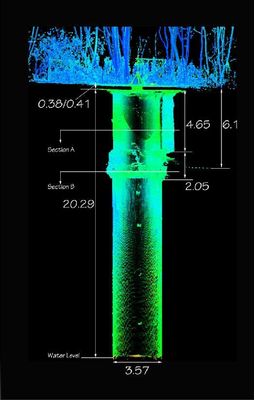
8 Multibeam Sonar profiling ranges to capture all data Ability to combine both sonar and laser scan data Swansea shaft surveyed down to 300m bgl 240m submerged

9 LTD. UNDERGROUND CAVITY SURVEYS Accurate 3D sub-surface survey position calculated Radius 100m WET to 150m DRY Results displayed in real time Geo-referenced 3D model of void Live video feed during works


10 OUTPUT DATA Full CAD compatibility Plans, Sections & 3D models Scan to BIM - Revit

11 OUTPUT DATA Full CAD compatibility Plans, Sections & 3D models Scan data can be output in dxf, ascii or pts Fully geo-referenced and locally referenced survey depending on clients needs Scan to BIM with level 1 or 2 model intelligence for Revit


12 RUGBY RAIL BRIDGE VOID SURVEYS Unknown void size Unknown number of voids and geo-referenced orientation Surveyed with C-ALS over two nightshifts
13 Case Study Subsurface Laser Scan survey Metaliferous mine void Drump Road, Redruth, Cornwall
14 Void encountered whilst drilling borehole on land adjacent to Penzance to London main railway line CCTV camera used unable to ascertain size, shape or orientation Possibility of railway line and adjacent buildings undermining Requested to carry out subsurface laser scan survey to produce a 3D geo-referenced model of the surface and underground void


15 Drump Road site and drilling rig in position adjacent to main railway line


16 CCTV inserted into void to see that it is a large hole. No indication of size, shape or orientation First borehole drilled into void

17 C-ALS inserted into void via borehole

18 Laser scan raw data relative to borehole location and drill path. Scan data available on site immediately to assist in positioning of further boreholes Void 3D Modelling relative to borehole location and drill path

19 Surface laser scan combined with subsurface laser scan survey
20 FINAL DELIVERABLES Combined 3D geo-referenced void and surface laser scan Confirmation that void does not undermine the main railway line or buildings, although large adjacent shaft is known Confirmation that there were no attached adits or tunnels Accurate volume calculated for backfilling Pre-works prior to new track slab install over shaft

21 Continuous void/shaft scanning whilst Keller s jet grouting through track slab
22 Case Study Subsurface Laser Scan Survey Collins Green Pit Shaft Wigan, Lancashire
23 Geoterra contacted by The Coal Authority in June 2015 Collins Green old mine shaft Capped in 1930 s Suspected collapsing of shaft lining Previously used a CCTV for inspection Requested to carry out laser scan survey to produce a full 3D georeferenced model Re-surveyed in June 2016 to determine any lining deformation


24

25

26

27

28 Repeated subsurface laser scan surveys deformation analysis

29 Production of 3D printer resin scaled models for physical assessment
30 LASER SCAN & SONAR SURVEY & DELIVERABLES SUMMATION Rapid deployment to site one day. No need for survey personnel to physically enter void or shaft Rapid collection of geo-referenced 3D laser scan & sonar survey on both the surface and subsurface via small access hole. Rapid turnaround of deliverables. 2D cross sections and plan sections. 3D measurable Navisworks scan to BIM model rolled out shaft walls and adits. Client, consultant engineer and contractor provided with accurate subsurface survey data to design remedial measures. RISK AVOIDANCE Ignore the dangers at your peril!!
31 Thank you for listening Any Questions?
Optimising the economic impact of 3D Laser scanning in Copper mining. by Kalumba Bwale, Lubambe Copper Mine Ltd
 Optimising the economic impact of 3D Laser scanning in Copper mining by Kalumba Bwale, Lubambe Copper Mine Ltd Characteristics of Lasers Gain and Inverse Population For four-level laser Boltzmann distribution
Mitigation of Gypsum Mine Voids Under SR-2 in Ottawa County, Ohio
 Subsurface Investigation and Conceptual Alternatives Mitigation of Gypsum Mine Voids Under SR-2 in Ottawa County, Ohio Presented By: Ohio Department of Transportation CH2M HILL CTL Engineering Technos,
Geologging Imagery, Applications and Geological Interpretation. Shea Altadonna 1, Jim Fulton 2, E.I.T.
 Geologging Imagery, Applications and Geological Interpretation Shea Altadonna 1, Jim Fulton 2, E.I.T. 1 Geologist, Advanced Construction Techniques Inc. 1000 N. West St. Ste 1200, Wilmington, DE 19801;
5 Further Case Histories
 5 Further Case Histories Chapter outline Cavity/old workings detection Detailed pillar detection Near-surface cavity detection Dyke, sill and fault detection In-seam disruptions (lenses, etc.) Coal thickness
Geotechnical Geotechnical Assessment
 Site Investigation Site Investigation Pile Probing Pile Probing Geotechnical Logging Geotechnical and Sampling Logging and Sampling Streetworks and Utilities Streetworks Avoidance and Utilities Avoidance
10. GEOTECHNICAL EXPLORATION PROGRAM
 Geotechnical site investigations should be conducted in multiple phases to obtain data for use during the planning and design of the tunnel system. Geotechnical investigations typically are performed in
Amistad Dam Investigation and Oversight: Karst- Founded Dam on the USA-Mexico Border
 Amistad Dam Investigation and Oversight: Karst- Founded Dam on the USA-Mexico Border Brook Brosi, CPG, PG USACE Lisa Nowicki Perks, PG USACE Kimberly Heenan, PE AECOM US Army Corps of Engineers BUILDING
GEOSPATIAL ENGINEERING COMPETENCIES. Core Geospatial Competencies
 GEOSPATIAL ENGINEERING COMPETENCIES Core Geospatial Competencies Which Underpin the Chosen Specialism Revision 2018: Security mindedness added to GE CORE 02E The measurement, definition and portrayal,
Pressure Grouting of Fractured Bedrock to Control Acid Mine Drainage
 WATER RESOURCES AT RISK May 14-18, 1995 Denver American Institute of Hydrology Pressure Grouting of Fractured Bedrock to Control Acid Mine Drainage S. A. Effner, G. D. Vandersluis, and V. Straskraba Hydro-Geo
High-precision NATM tunnelling through advanced surveying and monitoring technology. Klaus Rabensteiner
 High-precision NATM tunnelling through advanced surveying and monitoring technology Klaus Rabensteiner Introduction to Geodata www.geodata.com Activities o o o o Surveying Monitoring Instrumentation Software
TAKING THE MYSTERY OUT OF USACE S ER DRILLING IN EARTH EMBANKMENT DAMS AND LEVEES
 TAKING THE MYSTERY OUT OF USACE S ER 1110-1-1807 DRILLING IN EARTH EMBANKMENT DAMS AND LEVEES 237 237 237 217 217 217 200 200 200 80 119 27 252 174.59 1 255 255 255 0 0 0 163 163 163 131 132 122 239 65
ENCE 3610 Soil Mechanics. Site Exploration and Characterisation Field Exploration Methods
 ENCE 3610 Soil Mechanics Site Exploration and Characterisation Field Exploration Methods Geotechnical Involvement in Project Phases Planning Design Alternatives Preparation of Detailed Plans Final Design
Provincial Standards for Early Exploration
 Introduction Provincial Standards for Early Exploration Effective April 10, 2018 These Provincial Standards have been developed as part of the implementation of the graduated regulatory regime for early
Geological Models for Infrastructure Design:
 Geological Models for Infrastructure Design: Reducing Geotechnical Risk and Supporting Sustainability Alan Keith Turner Emeritus Professor of Geological Engineering CSM Visiting Research Associate - British
Background. Valley fills Sites in the Area. Construction over Mine Spoil Fills
 Construction over Mine Spoil Fills Wayne A. Karem, PhD, PE, PG, D.GE 2014 KSPE Annual Conference Background Strip mining; mountaintop and contour mining Creates huge quantities of mine spoil The mine spoil
LOZAR RADAR INTRODUCTORY PRESENTATION COAL SURVEYING
 LOZAR RADAR INTRODUCTORY PRESENTATION COAL SURVEYING WWW.LOZARRADAR.COM ABOUT LOZAR RADAR Lozar Radar is a ground-scanning device, which verifies and investigates the presence of mineral resources and
Airborne Corridor-Mapping. Planning and documentation of company infrastructure: precise, rapid, and cost effective
 Airborne Corridor-Mapping Planning and documentation of company infrastructure: precise, rapid, and cost effective Technology Airborne Laser-Scanning, digital orthophotos and thermal imaging: one flight
Mapping a Nation in 3D Singapore s Journey. Bryan Chew Registrar of Titles Assistant Chief Executive Singapore Land Authority
 Mapping a Nation in 3D Singapore s Journey Bryan Chew Registrar of Titles Assistant Chief Executive Singapore Land Authority Singapore Size - 719 sq km Population - 5.5 million Density 7,600/sq km Singapore
QuestUAV British UAV Manufacturer
 QuestUAV British UAV Manufacturer Aircraft designed to carry sensors such as high resolution cameras infra red cameras thermal and video cameras multiple payloads QuestUAV have been operating for five
Instituting Land Use Controls (LUCs) for Environmental Compliance and Planning
 for Environmental Compliance and Planning") Eleventh Air Force Instituting Land Use Controls (LUCs) for Environmental Compliance and Planning Robert Beachler GeoBase Administrator 611 Civil Engineer Squadron Elmendorf AFB, AK As of: 1 Agenda Introduction
Eleventh Air Force Instituting Land Use Controls (LUCs) for Environmental Compliance and Planning Robert Beachler GeoBase Administrator 611 Civil Engineer Squadron Elmendorf AFB, AK As of: 1 Agenda Introduction
Automated Seabed Mapping and Data Delivery in the Cloud
 Automated Seabed Mapping and Data Delivery in the Cloud London, 2nd November 2017 11/20/2017 1 2 WE CALL IT SEABED INTELLIGENCE Ocean Infinity are explorers. We go to unmapped locations to survey the seabed
STATE-0F-THE-ART MINE SUBSIDENCE EVALUATIONS
 STATE-0F-THE-ART MINE SUBSIDENCE EVALUATIONS Authored By: Kanaan Hanna, Jim Pfeiffer, Steve Hodges, and Fred Tolen Zapata Incorporated, Blackhawk Division, Golden, CO. Tel: 303-278-8700 khanna@zapeng.com
7 Years of Cutting Edge Technology for the Mining Industry in Canada
 7 Years of Cutting Edge Technology for the Mining Industry in Canada Verena Schreiner, BAUER Resources Canada Ltd The Bauer Group The Bauer Group The Bauer Group Segment Resources Three Main Competences
Nanometrics Posthole Seismometers. World Class Performance
 Contents Summary... 3 Performance of the Trillium Posthole versus World Class Vault Instruments... 3 Variation in Noise with Depth... 3 Installation Examples... 4 Shallow Bedrock Installation... 4 Thick
Instructional Objectives
 GE 6477 DISCONTINUOUS ROCK 8. Fracture Detection Dr. Norbert H. Maerz Missouri University of Science and Technology (573) 341-6714 norbert@mst.edu Instructional Objectives 1. List the advantages and disadvantages
Inspection of Waterfront Facilities Using Vessel-Based Remote Sensing Mitchell, Del Bello, Suarez
 Inspection of Waterfront Facilities Using Vessel-Based Remote Sensing Mitchell, Del Bello, Suarez American Association of Port Authorities Facilities Engineering Conference October 20-22, 2015 Waterfront
B-1 SURFACE ELEVATION
 5A 5B LOGGED BY El. S. Bhangoo DRILLING CONTRACTOR Pitcher Drilling DRILLING METHOD Rotary Wash BEGIN DATE 12-14-12 SAMPLER TYPE(S) AND SIZE(S) (ID) SPT, MC BOREHOLE BACKFILL AND COMPLETION COMPLETION
Engineer. Engineering. Engineering. (in-ja-neer ) A person trained and skilled in any of the various branches of engineering: a civil engineer
 A person trained and skilled in any of the various branches of engineering: a civil engineer") Engineer (in-ja-neer ) A person trained and skilled in any of the various branches of engineering: a civil engineer (Random House Webster s College Dictionary, 1991) CE100 Introduction to Civil Geotechnical
Engineer (in-ja-neer ) A person trained and skilled in any of the various branches of engineering: a civil engineer (Random House Webster s College Dictionary, 1991) CE100 Introduction to Civil Geotechnical
Scout Aerial Africa DRONES THE BIG PICTURE FOR GEOLOGY AND MINING
 Scout Aerial Africa DRONES THE BIG PICTURE FOR GEOLOGY AND MINING WHO ARE WE? Scout Aerial Group is a diversified operating and investment group with market leading businesses and targeted investment in
TIMELINE OF GEOMASTER
 Introduction Introduction TIMELINE OF GEOMASTER GEOMASTER LLC was established in January 1998 as an integrated professional high-tech geodetic and geophysical surveying and related service provider based
25th International Conference on Ground Control in Mining
 ANALYTICAL INVESTIGATION OF SHAFT DAMAGES AT WEST ELK MINE Tim Ross, Senior Associate Agapito Associates, Inc. Golden, CO, USA Bo Yu, Senior Engineer Agapito Associates, Inc. Grand Junction, CO, USA Chris
AERIAL DATA SERVICES
 AERIAL DATA SERVICES f o r I N D U S T R I A L A P P L I C AT I O N S C O N S T R U C T I O N * A G R I C U L T U R E * E N E R G Y * E N V I R O N M E N T A L A e r o L o g i x C o n s u l t i n g I n
Engineering Geophysical Application to Mine Subsidence Risk Assessment
 Engineering Geophysical Application to Mine Subsidence Risk Assessment By: Kanaan Hanna, Sr. Mining Engineer Steve Hodges, Sr. Geophysicist Jim Pfeiffer, Sr. Geophysicist Dr. Keith Heasley, Professor West
FIG WW Evaluation of Mobile Mapping System (MMS) Survey for Public Housing Estates in Hong Kong. Winnie SHIU. Senior Land Surveyor.
 Survey for Public Housing Estates in Hong Kong. Winnie SHIU. Senior Land Surveyor.") FIG WW 2012 Evaluation of Mobile Mapping System (MMS) Survey for Public Housing Estates in Hong Kong Winnie SHIU Senior Land Surveyor 9 May 2012 Housing Department 1953 Big Fire in Squatter Area Constructed
FIG WW 2012 Evaluation of Mobile Mapping System (MMS) Survey for Public Housing Estates in Hong Kong Winnie SHIU Senior Land Surveyor 9 May 2012 Housing Department 1953 Big Fire in Squatter Area Constructed
Observation of Deep Seafloor by Autonomous Underwater Vehicle
 Indian Journal of Geo-Marine Sciences Vol. 42 (8), December 2013,pp. 1028-1033 Observation of Deep Seafloor by Autonomous Underwater Vehicle Tamaki Ura 1 Underwater Technology Research Center, Institute
US ARMY CORPS OF ENGINEERS New England District BUILDING STRONG
 US ARMY CORPS OF ENGINEERS New England District STUDIES Sediment Sampling Biological Sampling (benthic community analysis) Hydroacoustic Surveys (side scan sonar, bathymetry) Remotely Operated Vehicle
REVIEW MAPWORK EXAM QUESTIONS 31 JULY 2014
 REVIEW MAPWORK EXAM QUESTIONS 31 JULY 2014 Lesson Description In this lesson we: Focus on key concepts and exam questions relating to GIS. Question 1 Test Yourself The most important component of a GIS
Geotechnical Monitoring for Safe Excavation of Large Rock Cavern: A Case Study
 The 31st International Symposium on Automation and Robotics in Construction and Mining (ISARC 2014) Geotechnical Monitoring for Safe Excavation of Large Rock Cavern: A Case Study A.Mandal a, C. Kumar b,
HKND Group Ltd Grand Canal Project
 HKND Group Ltd Grand Canal Project General Overview of Aerial Survey Project Managua, Nicaragua September 21 st 2015 Presented by: Jeff Elliott Managing Director CSA Global About CSA Global CSA Global
STORMWATER ASSET MANAGEMENT:
 STORMWATER ASSET MANAGEMENT: THE ROLE OF GIS IN ASSET MANAGEMENT Janice Lerg, Hubbell, Roth & Clark, Inc. Brian McElroy, Hubbell, Roth & Clark, Inc. Kevin Fowler, Hubbell, Roth & Clark, Inc. IMAGIN CONFERENCE
P R O U D LY C A N A D I A N
 P R O U D LY C A N A D I A N 1.855.423.3185 info@rmegeomatics.com AERIAL SURVEYING IMAGING TERRAIN ANALYSIS WHO WE ARE HSE & REGULATORY CLIENT INDUSTRIES RME Geomatics (formerly NGF Geomatics) was founded
MICRO TO MACRO ARE UK LINEAR INFRASTRUCTURE GI S SUITABLE FOR INVESTIGATING MASS SOIL PROPERTY CHARACTERISTICS?
 MICRO TO MACRO ARE UK LINEAR INFRASTRUCTURE GI S SUITABLE FOR INVESTIGATING MASS SOIL PROPERTY CHARACTERISTICS? Ben Gilson - Arup 1 OUTLINE 1. Context why linear infrastructure? 2. Geotechnical challenges
Deep Mill Level Zone, PT Freeport Indonesia From Feasibility to Production. May 2016
 Deep Mill Level Zone, PT Freeport Indonesia From Feasibility to Production May 2016 Contents Location and Topography Geology and History Reserves and Strategic Timing Timeline/Mine Overview Conveyor Decline
IAEA SAFETY STANDARDS Geotechnical Aspects of Site Evaluation and Foundations in NPPs, NS-G-3.6
 IAEA SAFETY STANDARDS Geotechnical Aspects of Site Evaluation and Foundations in NPPs, NS-G-3.6 Regional Workshop on Volcanic, Seismic, and Tsunami Hazard Assessment Related to NPP Siting Activities and
16 January 2018 Job Number: RICHARD NEWMAN C\- CLARK FORTUNE MCDONALD AND ASSOCIATES PO BOX 553 QUEENSTOWN
 16 January 2018 Job Number: 50595 RICHARD NEWMAN C\- CLARK FORTUNE MCDONALD AND ASSOCIATES PO BOX 553 QUEENSTOWN CHANSEN@CFMA.CO.NZ STORMWATER DISPOSAL ASSESSMENT Dear Richard, RDAgritech were requested
North Goonyella Outburst Incident Learnings
 North Goonyella Outburst Incident Learnings June 19, 2013 David Craft Technical Services Manager Introduction North Goonyella Coal Mine & Outburst History Outburst incident May 2012 Lessons learnt We ought
Hydraulic Impacts of Limestone Quarries and Gravel Pits. Jeff Green Minnesota DNR-Division of Ecological & Water Resources
 Hydraulic Impacts of Limestone Quarries and Gravel Pits Jeff Green Minnesota DNR-Division of Ecological & Water Resources The Hydraulic Impacts of Limestone Quarries and Gravel Pits Study was funded by
Observation of Deep Seafloor by Autonomous Underwater Vehicle
 Observation of Deep Seafloor by Autonomous Underwater Vehicle Tamaki Ura 1 Underwater Technology Research Center Institute of Industrial Science, The University of Tokyo 4-6-1, Komaba, Minato, Tokyo, Japan
VISUALIZING THE SMART CITY 3D SPATIAL INFRASTRUCTURE GEOSMART ASIA- 30 SEP, 2015
 www.aamgroup.com VISUALIZING THE SMART CITY 3D SPATIAL INFRASTRUCTURE GEOSMART ASIA- 30 SEP, 2015 Agenda AAM What is a Smart City? Data Acquisition 3D Modelling Benefits Questions AAM AAM is a Geospatial
Techniques for Science Teachers: Using GIS in Science Classrooms.
 Techniques for Science Teachers: Using GIS in Science Classrooms. After ESRI, 2008 GIS A Geographic Information System A collection of computer hardware, software, and geographic data used together for
Detecting adverse coal-seam geology ahead of mining using advanced radiowave geophysics, and recent longwall applications
 The Southern African Institute of Mining and Metallurgy Surface Mining 2014 J. Duncan and L.G. Stolarczyk Detecting adverse coal-seam geology ahead of mining using advanced radiowave geophysics, and recent
IODP Expedition 341S: SCIMPI and 858G ReCORK. Week 1 Report (19 27 May 2013) Operations. Victoria Port Call and Transit to Hole 858G
 Operations. Victoria Port Call and Transit to Hole 858G") IODP Expedition 341S: SCIMPI and 858G ReCORK Week 1 Report (19 27 May 2013) Operations Victoria Port Call and Transit to Hole 858G IODP SCIMPI and 858G ReCORK Expedition (341S) officially began when the
IODP Expedition 341S: SCIMPI and 858G ReCORK Week 1 Report (19 27 May 2013) Operations Victoria Port Call and Transit to Hole 858G IODP SCIMPI and 858G ReCORK Expedition (341S) officially began when the
CASE STUDY ON THE REMEDIATION OF WATER INGRESS TO OLD GOLD WORKINGS LINKED TO ACTIVE MINING AREAS IN SOUTH AFRICA 1
 CASE STUDY ON THE REMEDIATION OF WATER INGRESS TO OLD GOLD WORKINGS LINKED TO ACTIVE MINING AREAS IN SOUTH AFRICA 1 Mike Palmer 2, Chris Waygood, Irene Lea Abstract. Grootvlei Mine is located in the Far
Identified a possible new offset location where the customer is currently exploring drill options.
 GroundMetrics was hired to conduct a Full-Field Resistivity Survey for an oil and gas producer that needed to make crucial decisions to drive profitability at the location. The results saved them hundreds
For personal use only
 11 MAY 2011 ASX : NAE ASX ANNOUNCEMENT Acquisition of Coal Concessions in Cesar Basin, Colombia New Age Exploration Limited ( NAE ) announces that it has entered into binding agreements to acquire two
RISK ASSESSMENT OF FEASIBILITY OF ROADHEADERS IN ESTONIAN UNDERGOUND MINING
 Oil Shale, 2008, Vol. 25, No. 2 Special, pp. 153 162 ISSN 0208-189X doi: 10.3176/oil.2008.2S.07 2008 Estonian Academy Publishers RISK ASSESSMENT OF FEASIBILITY OF ROADHEADERS IN ESTONIAN UNDERGOUND MINING
PRO GEO GEOTECHNICAL CONSULTANTS SHORT PRESENTATION BARCELONA, SPAIN
 PRO GEO GEOTECHNICAL CONSULTANTS SHORT PRESENTATION BARCELONA, SPAIN Address: Benet Mateu 30, Bajos 2ª. 08034 Barcelona (Spain) Phone: +34 93 534 01 23 Web: www.progeo-cga.com e-mail: direccion@progeo-cga.com
The investigation of underground streams in a weathered granite terrain in Hong Kong
 The investigation of underground streams in a weathered granite terrain in Hong Kong S. R. Hencher Halcrow China Ltd.; Leeds University, UK H. W. Sun & K. K. S. Ho Geotechnical Engineering Office, Civil
DATA SOURCES AND INPUT IN GIS. By Prof. A. Balasubramanian Centre for Advanced Studies in Earth Science, University of Mysore, Mysore
 DATA SOURCES AND INPUT IN GIS By Prof. A. Balasubramanian Centre for Advanced Studies in Earth Science, University of Mysore, Mysore 1 1. GIS stands for 'Geographic Information System'. It is a computer-based
GIS data classes used within the November 2013 Environmental Statement Engineering Maps
 LWM-HS2-EN-DAT-000-000001 P01 22 January 2014 GIS data classes used within the November 2013 Environmental Statement Engineering Maps Document No.:LWM-HS2-EN-DAT-000-000001 Revision Author Checked by Approved
Closure of Remote Historic Underground Mines in Desert Environments
 Closure of Remote Historic Underground Mines in Desert Environments James A. Cremeens Agapito Associates, Inc. Michael H. Rauschkolb U.S. Borax, Inc. 2002 SME Annual Meeting and Exhibit Geotechnical solutions
An Introduction to Field Explorations for Foundations
 An Introduction to Field Explorations for Foundations J. Paul Guyer, P.E., R.A. Paul Guyer is a registered mechanical engineer, civil engineer, fire protection engineer and architect with over 35 years
Civil Engineering, Surveying and Environmental Consulting WASP0059.ltr.JLS.Mich Ave Bridge Geotech.docx
 2365 Haggerty Road South * Canton, Michigan 48188 P: 734-397-3100 * F: 734-397-3131 * www.manniksmithgroup.com August 29, 2012 Mr. Richard Kent Washtenaw County Parks and Recreation Commission 2330 Platt
September 18, 2017 Project No.: 5077
 #109 3011 Underhill Avenue Burnaby, BC V5A 3C2 Phone: (604) 421-3288 Email: info@terrangeo.com September 18, 2017 Project No.: 5077 Kevin Brooks City of Campbell River 301 St. Ann s Road Campbell River,
Application of 3D Laser Scanning and Digital Tools in Preparing Conservation Management Plan Report for Masjid Negara Kuala Lumpur
 GLOBAL HERITAGE CONSULTANCY SDN. BHD. Application of 3D Laser Scanning and Digital Tools in Preparing Conservation Management Plan Report for Masjid Negara Kuala Lumpur digital solution & visualization
ENGINEERING GEOLOGY "Underground, Overground "
 Edinburgh Career and Industry Day WELCOME 2017 www.geolsoc.org.uk ENGINEERING GEOLOGY "Underground, Overground " Katerina Braun CGeol EurGeol MSc BSc (Hons) FGS Chris Jack CGeol EurGeol MSc BSc (Hons)
Management Plan. Slevin Underground Project Area (SUPA) & Martha Drill Drive Project (MDDP) Void Management Plan WAI-400-PLN-011
 & Martha Drill Drive Project (MDDP) Void Management Plan WAI-400-PLN-011") Management Plan Slevin Underground Project Area (SUPA) & Martha Drill Drive Project (MDDP) Void Management Plan WAI-400-PLN-011 This is no longer a controlled document once printed. This document must
Management Plan Slevin Underground Project Area (SUPA) & Martha Drill Drive Project (MDDP) Void Management Plan WAI-400-PLN-011 This is no longer a controlled document once printed. This document must
In-seam GPR and 2-C seismic investigations at the Goderich, Ontario salt mine
 In-seam GPR and 2-C seismic investigations at the Goderich, Ontario salt mine Jill Belisle and Robert R. Stewart In-seam techniques ABSTRACT In-seam GPR and 2-C seismic techniques used in conjunction with
On August 10, 2017, I conducted an inspection of the exploration site associated with Permit PR The inspection report is attached.
 Ministry of Northern Development and Mines Mineral Development and Lands Branch B002 435 James Street South Thunder Bay, Ontario P7E 6S7 Tel.: 807-475-1123 (reception) Fax: 807-475-1112 Ministère du Développement
Washington, D.C. Laura Benneyworth AMEC, Nashville, TN February 2009
 Turning Data Into Information at Wolf Creek Dam ESRI s Federal User s Conference, Washington, D.C. Laura Benneyworth AMEC, Nashville, TN February 2009 Wolf Creek Dam Acknowledgments USACE, Nashville District
NEW SEAFLOOR INSTALLATIONS REQUIRE ULTRA-HIGH RESOLUTION SURVEYS
 NEW SEAFLOOR INSTALLATIONS REQUIRE ULTRA-HIGH RESOLUTION SURVEYS Donald Hussong (Fugro Seafloor Surveys, Inc.) dhussong@fugro.com Fugro Seafloor Surveys, Inc., 1100 Dexter Avenue North (Suite 100), Seattle,
SEPTEMBER 1991 MONTHLY REPORT. Scientific Observation Hole (SOH) Geothermal Resource Permit: GRP TMK: :01; :02; and :32
 Geothermal Resource Permit: GRP TMK: :01; :02; and :32") SEPTEMBER 1991 MONTHLY REPORT Scientific Observation Hole (SOH) Program Geothermal Resource Permit: GRP 89-1 Lilewa, Kapoho, and Halekamahina, Hawaii TMK: 1-2-10:01; 1-4-01:02; and 1-4-02:32 Hawaii Natural
SEPTEMBER 1991 MONTHLY REPORT Scientific Observation Hole (SOH) Program Geothermal Resource Permit: GRP 89-1 Lilewa, Kapoho, and Halekamahina, Hawaii TMK: 1-2-10:01; 1-4-01:02; and 1-4-02:32 Hawaii Natural
inovitas be on site with infra3d
 inovitas be on site with infra3d be inspired... Infrastructure has an immense property value and is a prerequisite for a functioning competitive economy. In this context, the modes of transport such as
Sonic Drilling Offers Quality Control and Non-destructive Advantages to Geotechnical and Construction Drilling on Sensitive Infrastructure Sites
 Sonic Drilling Offers Quality Control and Non-destructive Advantages to Geotechnical and Construction Drilling on Sensitive Infrastructure Sites John P. Davis Manager, Construction Drilling Services Boart
Offshore Operations and Project Execution Geophysical Site Surveys
 Offshore Operations and Project Execution Geophysical Site Surveys Chris Almond Senior Geophysicist Fugro Survey Limited 22/04/2015 Presentation Summary: Office-based Personnel Project Awarded Pre Offshore
Use of GPR on two sites with voids to enable safer work and targeted probing
 Geotechnical and Geophysical Site Characterisation 5 Lehane, Acosta-Martínez & Kelly (Eds) 2016 Australian Geomechanics Society, Sydney, Australia, ISBN 978-0-9946261-2-7 Use of GPR on two sites with voids
Mineral Exploration in Ontario October 2017 An overview prepared by Northwatch for the NWT Mineral Resources Act Workshop
 Mineral Exploration in Ontario October 2017 An overview prepared by Northwatch for the NWT Mineral Resources Act Workshop Author: Brennain Lloyd, Northwatch The Ontario Context The first metal mine to
Coordinate Measurement Machine
 Inspection Tools Coordinate Measurement Machine Application: Measure distance, radius, diameter, and Z-height Stage dimensions: Objectives: 0.5X, 2.5X Variable zoom Units: US Standard, Metric Contact:
Investigation into the computational techniques of power system modelling for a DC railway
 Power Supply System Analysis, Design and Planning 123 Investigation into the computational techniques of power system modelling for a DC railway A. Finlayson 1, C. J. Goodman 2 & R. D. White 1 1 Atkins
HOW. HOW vehicle mounted units portable units also available. HOW, WHEN & WHY to Geophysically Log in S.I.?
 HOW, WHEN & WHY to Geophysically Log in S.I.? by Kim Beesley HOW HOW vehicle mounted units portable units also available Access to borehole Depth of borehole sump / rat -hole? 1 HOW? - subject to borehole
EFFECTIVENESS OF HYDROFRACTURE PREDICTION FOR HDD DESIGN
 North American Society for Trenchless Technology (NASTT) No-Dig Show 2010 Chicago, Illinois May 2-7, 2010 Paper F-1-01 EFFECTIVENESS OF HYDROFRACTURE PREDICTION FOR HDD DESIGN Kimberlie Staheli, Ph.D.,
Central Queensland Coal Project Appendix 4b Geotechnical Assessment. Environmental Impact Statement
 Central Queensland Coal Project Appendix 4b Geotechnical Assessment Environmental Impact Statement GEOTECHNICAL ASSESSMENT OF OPEN CUT MINING ADJACENT TO THE BRUCE HIGHWAY, CENTRAL QUEENSLAND COAL PROJECT
How to Interpret Mining Company Drill Reports & Announcements
 How to Interpret Mining Company Drill Reports & Announcements A Simple Guide amscot Stockbroking Pty Ltd A division of State One Stockbroking Ltd (AFSL 247 100) Disclaimer: All information in this document
MSCL-S: MULTI-SENSOR CORE LOGGER NON-DESTRUCTIVE CONTINUOUS CORE SCANNING FOR INDUSTRY & RESEARCH
 MSCL-S: MULTI-SENSOR CORE LOGGER NON-DESTRUCTIVE CONTINUOUS CORE SCANNING FOR INDUSTRY & RESEARCH IF CORE S WORTH TAKING, IT S WORTH LOGGING AUTOMATED & FLEXIBLE CORE LOGGING & SCANNING The Geotek Standard
Guidelines for the Form of Reports and Illustrations
 Guidelines for the Form of Reports and Illustrations as Prescribed by the Minister as per Section 55(2) of The Consolidated Newfoundland and Labrador Regulation 1143/96 (As Amended) (Revised - December,
1 General introduction
 1 General introduction 1.1 Oil well drilling system Oil and other hydrocarbons are the primary source of global energy. However, the exploration of these hydrocarbons presents a myriad of challenges resulting
GEOTECHNICAL INVESTIGATION REPORT
 GEOTECHNICAL INVESTIGATION REPORT SOIL INVESTIGATION REPORT FOR STATIC TEST FACILITY FOR PROPELLANTS AT BDL, IBRAHIMPATNAM. Graphics Designers, M/s Architecture & Engineering 859, Banjara Avenue, Consultancy
ATTACHMENT A PRELIMINARY GEOTECHNICAL SUMMARY
 ATTACHMENT A PRELIMINARY GEOTECHNICAL SUMMARY Kevin M. Martin, P.E. KMM Geotechnical Consultants, LLC 7 Marshall Road Hampstead, NH 0384 603-489-6 (p)/ 603-489-8 (f)/78-78-4084(m) kevinmartinpe@aol.com
Bridging Subsurface Geologic Databases with Cross-Sections in GIS
 Bridging Subsurface Geologic Databases with Cross-Sections in GIS Eva E. von Thury ESRI International User Conference Padre Associates, Inc. Project Geologist / GIS Analyst June 29, 2016 Outline Introduction
Global Monitoring of Changes in the Rock Mass Arising as a Result of Filling the Mining Workings with Wastes.
 Global Monitoring of Changes in the Rock Mass Arising as a Result of Filling the Mining Workings with Krzysztof PIETRUSZKA, Poland Key words: rock mass deformations, FEM modeling, geoinformatics SUMMARY
GEOTECHNICAL INVESTIGATION OF RAILWAYS
 GEOTECHNICAL INVESTIGATION OF RAILWAYS Prof. Hannes Gräbe University of Pretoria Transnet Chair in Railway Engineering May 2011 Contents Cost considerations Objectives Phased approach to site investigation
Rotary Drilling Rotary Drilling Bits
 GE 343 SUBSURFACE EXPLORATION CH 8 Rock Drilling, Testing, and Sampling Text Ch. 7. Dr. Norbert H. Maerz Missouri University of Science and Technology (573) 341-6714 norbert@mst.edu Instructional Objectives
MEDAT-2: Some Geotechnical Opportunities. Site Characterization -- Opportunities. Down-hole CPT & vane (Fugro)
") MEDAT-2: Some Geotechnical Opportunities Ross W. Boulanger Department of Civil & Environmental Engineering University of California Davis, California 95616-5294 rwboulanger@ucdavis.edu Presentation for
MEDAT-2: Some Geotechnical Opportunities Ross W. Boulanger Department of Civil & Environmental Engineering University of California Davis, California 95616-5294 rwboulanger@ucdavis.edu Presentation for
Earthquake Commission Darfield Earthquake Recovery Geotechnical Factual Report New Brighton
 REPORT Earthquake Commission Darfield Earthquake Recovery Geotechnical Factual Report New Brighton REPORT Earthquake Commission Darfield Earthquake Recovery Geotechnical Factual Report New Brighton Report
DETECTING ADVERSE COAL SEAM GEOLOGYAHEAD OF MINING USING ADVANCED RADIOWAVE GEOPHYSICS
 The South African Institute of Mining and Metallurgy SURFACE MINING 2014 16 September 2014 Session 2: 10:35 11:00 DETECTING ADVERSE COAL SEAM GEOLOGYAHEAD OF MINING USING ADVANCED RADIOWAVE GEOPHYSICS
The fields of application of the Ground Penetrating Radar (GPR) are: CONSTRUCTION APPLICATIONS
 are: CONSTRUCTION APPLICATIONS") I.Industrial (technical) applications of geophysical methods used by the Archeo-geophysics laboratory in construction, plumbing, geotechnical engineering, engineering geology, mining, electricity power
I.Industrial (technical) applications of geophysical methods used by the Archeo-geophysics laboratory in construction, plumbing, geotechnical engineering, engineering geology, mining, electricity power
Laser Scanning Increased Confidence = Reduced Risk
 Laser Scanning Increased Confidence = Reduced Risk Matthew McCarter - Surveyor Working in survey industry 16 years Started laser scanning in 2000 Advisory committee for SPAR EU and GeoBusiness conferences
MODERNIZATION OF THE MUNICIPAL MAPPING USING HIGH END GNSS SYSTEM AND GIS SOFTWARE
 MODERNIZATION OF THE MUNICIPAL MAPPING USING HIGH END GNSS SYSTEM AND GIS SOFTWARE Mr. R. A. R. Khan Assistant Engineer, Sewerage Utility Management Centre (SUMC) Municipal Corporation Of Greater Mumbai
Fin design mission. Team Members
 Fin design mission Team Members Mission: Your team will determine the best fin design for a model rocket. You will compare highest altitude, flight characteristics, and weathercocking. You will report
Hydro One (Sept 2014) Hydro One (Sept 2014) Hydro One (Sept 2014)
 Hydro One (Sept 2014) Hydro One (Sept 2014)") TABLE 1 WELL CONSTRUCTION DETAILS MOE WWR No Well ID Location Installation Date Status Easting Coordinates Northing Source Elevation Screened Interval Screened Material Borehole Well Stick-up Ground Top
TABLE 1 WELL CONSTRUCTION DETAILS MOE WWR No Well ID Location Installation Date Status Easting Coordinates Northing Source Elevation Screened Interval Screened Material Borehole Well Stick-up Ground Top