Laser Scanning Increased Confidence = Reduced Risk
|
|
|
- Cameron Mills
- 6 years ago
- Views:
Transcription


1 Laser Scanning Increased Confidence = Reduced Risk


2 Matthew McCarter - Surveyor Working in survey industry 16 years Started laser scanning in 2000 Advisory committee for SPAR EU and GeoBusiness conferences Active in UK BIM community Member of Cabinet Office BIM Task Group Survey4BIM committee Blog on SPAR Point Group Website Speaker at Autodesk 18 March 2014
3 What is a surveyor?
4 Surveyors Many different names: LAND SURVEYOR SURVEYOR GEOMATIC ENGINEER GEOSPATIAL SURVEYOR MEASURED BUILDING SURVEYOR GEOMATICIAN GEOMATIC SURVEYOR GEOSPATIAL ENGINEER


5 What does a Land Surveyor do?... explore the character and structure of spatial information, its methods of capture, organisation, classification, qualification, analysis, management, display and dissemination, as well as the infrastructure and technologies necessary for the optimal use of this information

6 Essentially, we measure distances & angles


7 Our mission is to provide a forum for survey organisations and industry professionals to collaborate and share their journey putting BIM into practice, and to provide best practice CLIENTS VENDORS guidance documents on survey matters relating to BIM.


8 BIM Task Group BIM4 Communities
9 Group Goals Provide leadership in establishing how surveyors are integral to the BIM process Share knowledge and learning between its members Establish collaborative links to Universities and academia Produce and publish best practise guidance on survey matters relating to BIM Coordinate the Survey4BIM activates within survey bodies and institutions Promote survey related case studies, which demonstrate best practice


10 Get Involved or Contact Us Survey4BIM Group
11 Laser Scanning


12 Measurement Options-Traditional Typically single point acquisition Tape Measure GPS / GNSS Total Station


13 Measurement Options-Mass Data Rapid, multiple point acquisition Laser Scanner GLS-2000 Mobile Mapping IPS-3 Aerial Survey Falcon 8/Sirius Pro


14 Laser Scanning Key Features Selectable Dual Laser Class 1 = Eye safe and invisible Class 3R = 350m+ range

15 Laser Scanning Laser Scanner Sector Applications - Architecture

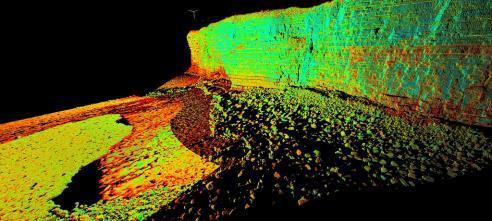
16 Point Cloud

17 Our process works fine without point clouds

18 Gartner hype cycle for emerging technologies

19 3D Scanning adoption Sources:
20 Where to use Laser Scanning?

21 Construction


22 Buildings Multiple uses


23 Topographic and utility surveys


24 Coastal


25 Heritage

26 Power and Utility Surveys
27 Power and Utility Surveys


28 Plant and M & E

29 Internal Building Surveys


30 Leisure-Golf Courses

31 Collision Investigation

32 Aerospace
33 Survey & Laser Scanning in BIM


34 Client Guide to 3D Scanning and Data Capture First BIM Task Group Technical Guide Cross industry involvement Guide-to-3D-Scanning-and-Data-Capture.pdf 18 March 2014
35 Timeline of 3D Scanning Development 18 March 2014

36 D Scanning Basics

37 Capture Quickly + Accurately


38 Level of Detail Not LOD 50mm point 10m distance


39 Level of Detail Not LOD 25mm point 10m distance


40 Level of Detail Not LOD 12.5mm point 10m distance


41 Level of Detail Not LOD 6.3mm point 10m distance


42 Level of Detail Not LOD 3.1mm point 10m distance


43 Survey Deliverables Point Cloud Options Raw Scan Data Registered Point Cloud Geo-Referenced Point Cloud Vector Options 2D Drawings 3D Wireframe 3D Surface / Solid Model Building Information Model Visualisation Surveyor Information Delivery

44 RIBA Digital Plan Of Work


45 How Site Capture Aligns To dpow Site Context Required Validation Operate, Maintain + Update Site Survey/s Required
46 Minimise Risk Through The Project Lifecycle Value of survey work implemented early in project lifecycle Impact v Cost

47 0 Strategic Definition
48 0 Strategic Definition Is there any existing measured survey? Client Risks Lack of reliable Data on which to make decisions What do I have to start with? Lack of understanding of available data and possible data and their implications Lack of available, reliable professional consultation
49 1-Preparation and Brief Develop project objectives, outcomes, budget, feasibility & brief Client Risks Lack of Survey data What is purpose/accuracy/age of the Survey Data Different co-ordinate systems Misaligned Expectations Lack of a Common Technical Language Over-surveying or Wrongly identified Data Journey Lack of Survey Expertise


50 1-Preparation and Brief PROCESS Mass Data Collection TOOLS Software: Scanmaster WORKFLOW Photography/Mesh/ Pointcloud Point cloud from vehicle mounted mobile laser scan
51 2- Concept Design Outline proposals for structural design, building services, project strategies. Issue final project brief. Client Risks Poor survey specification Level of detail Accuracy Grid Lack of survey budget Poor design definition Lack of or poor Common Data Environment (CDE) & processes


52 It s this easy right?

53 Scan 2 BIM

54 Scan 2 BIM

55 Scan 2 BIM
56 3-Developed Design Coordinated proposals for structural design, building services, project strategies, cost information and project strategies Client Risks Failure to verify survey data available Resources underused due to waiting for required survey data Designers or program delayed due to lack of sufficient survey data Survey data delivered but not shared or used to its potential Hidden design assumptions in relation to survey data reliability - not understood or not identified in risk register contingency


57 3-Developed Design Image courtesy of
58 4-Technical Design Prepare Technical Design for architectural, structural and building services information in accordance with Design Responsibility Matrix and Project Strategies Client Risks Loss of survey control on site Re-surveys = Delays on site, increased cost + risk Uncontrolled site changes = Significant lag since last stages of surveys Lack of data currency


59 4-Technical Design 1. Re-use scan data from previous stages 2. Compare original point clouds to technical design prior to construction 3. Efficient process, reducing duplication of re-survey
60 5-Construction Offsite manufacturing and onsite Construction in accordance with Construction Programme and resolution of Design Queries from site as they arise. Client Risks Rework causes delays and large additional costs Poor survey control Offsite manufactured components don t fit where intended Works destruction of survey control Coordination of survey activities (e.g. Monitoring v As-built) Not recording as-built and planning for hand-back Competence of survey resource Continued collaboration

61 5-Construction

62 5-Construction Laser Scan at project milestones Record point clouds of key components Underground services, core, structural elements, MEP, dry wall etc Compare scanned objects to design model Compare to project program in a quantifiable and auditable way. Monitor site progress & compare against program Identify re-work early Simplify prefabrication Design model migrates to As Constructed? Generates true as built 3D BIM for use by CAFM systems.
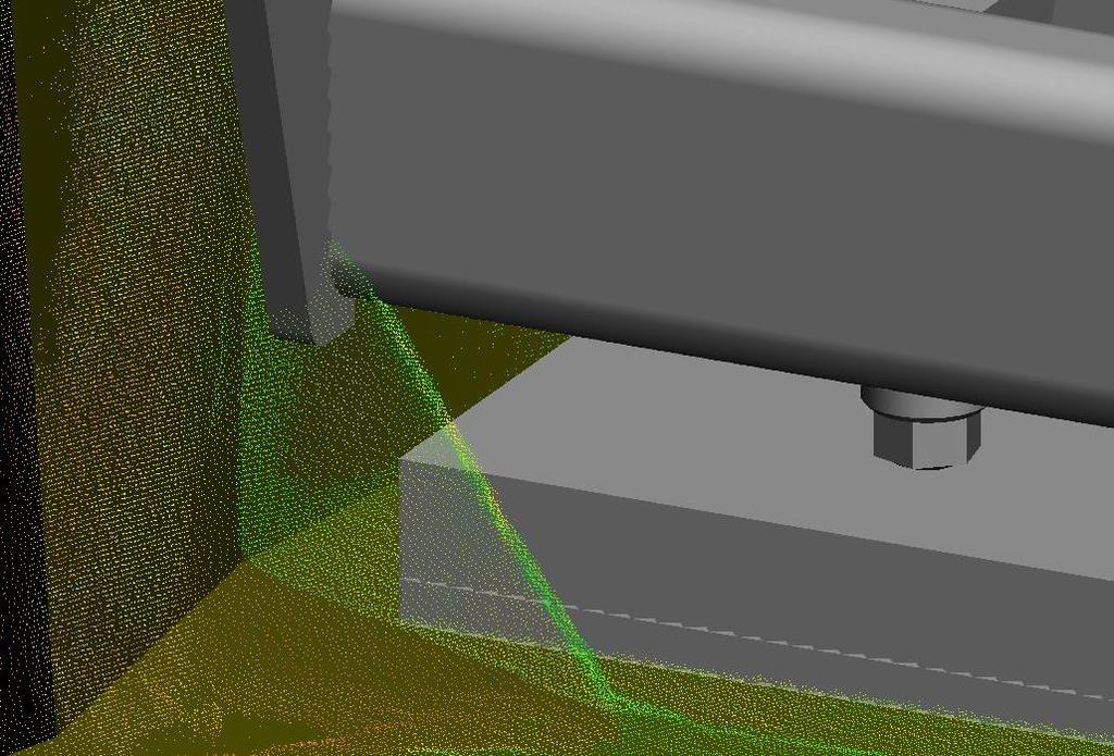

63 5-Construction Detect clashes before site work

64 5-Construction Point clouds in setting out process

65 5-Construction Setting Out On Site

66 5-Construction Setting Out On Site
67 6-Handover and Close Out Handover of building and conclusion of Building Contract Client Risks Lack of survey at construction stages or final stage Redline.pdf file is only as built data handed over No budget left for as-built survey As built survey unverified As built survey only to final visible finishes Lack of verification and validation data at close out stage Complete loss of survey control network


68 6-Handover and Close Out As Builts Current Practice Post construction handover drawings and documents Typical Industry current practice Set of 2D pdf files derived from design Set of Operation & Maintenance manuals Measured survey rarely performed

69 6-Handover and Close Out As Builts Future Practice? Generate as built model from multiple stage 5 laser scans Hidden objects recorded and validated Whilst built model compiled in near real time The Information of BIM is retained from design/fabrication model The FM community rejoice
70 7 - In use Undertake In Use services in accordance with Schedule of Services Client Risks No proper as built survey undertaken at end of construction Building services (MEP) not verified in as built survey Provenance of other peoples data Lack of standards, codes & specifications RICS client specification is not a standard Lack of responsibility for who should update model/cde when changes occur


71 7 - In use Minor works and maintenance changes Capture every change, or need XX per area to trigger recapture? Monitor building performance combine laser scan with thermal camera
72 Things to consider if you start using this data
73 Point Cloud Files RDS TXT RCP ASC PTG ZFS 3DD PCD SOI RCS CLR RXP XYZ PN PCG FLS ZFSPROJ RDB VTK PTX POD CL3 LAS BIN RSP


74 Point Cloud Files RDS TXT RCP ASC PTG ZFS 3DD PCD SOI RCS CLR RXP XYZ PN PCG FLS ZFSPROJ RDB VTK PTX POD CL3 LAS BIN RSP


75 Data Storage Massive Files Big data
76 Thank you. Questions?
Coordinate systems, measured surveys for BIM, total station for BIM, as-built surveys, setting-out
 Coordinate systems, measured surveys for BIM, total station for BIM, as-built surveys, setting-out What is a BIM What does a BIM do Why use a BIM BIM Software BIM and the Surveyor How do they relate to
Exploring the boundaries of your built and natural world. Geomatics
 Exploring the boundaries of your built and natural world Geomatics Before the Luxor brought magic to the Las Vegas strip and before the South LRT extension in Edmonton gave residents a new route to travel,
GEOMATICS SURVEYING AND MAPPING EXPERTS FOR OVER 35 YEARS
 GEOMATICS SURVEYING AND MAPPING EXPERTS FOR OVER 35 YEARS 2 GEOMATICS AND SURVEYING SOLUTIONS SPANNING THE ENTIRE PROJECT LIFECYCLE 1,000+ 250+ 24 Surveying professionals Active field crews Geomatics offices
GEOSPATIAL ENGINEERING COMPETENCIES. Core Geospatial Competencies
 GEOSPATIAL ENGINEERING COMPETENCIES Core Geospatial Competencies Which Underpin the Chosen Specialism Revision 2018: Security mindedness added to GE CORE 02E The measurement, definition and portrayal,
GEOMATICS. Shaping our world. A company of
 GEOMATICS Shaping our world A company of OUR EXPERTISE Geomatics Geomatics plays a mayor role in hydropower, land and water resources, urban development, transport & mobility, renewable energy, and infrastructure
Mapping a Nation in 3D Singapore s Journey. Bryan Chew Registrar of Titles Assistant Chief Executive Singapore Land Authority
 Mapping a Nation in 3D Singapore s Journey Bryan Chew Registrar of Titles Assistant Chief Executive Singapore Land Authority Singapore Size - 719 sq km Population - 5.5 million Density 7,600/sq km Singapore
Investigating the practical relationship between GIS and BIM; then relating that to a 3D cadastre. J. Gabriel van Wyk, Johan Nel
 Investigating the practical relationship between GIS and BIM; then relating that to a 3D cadastre. J. Gabriel van Wyk, Johan Nel Overview So exactly what is BIM? Available BIM offerings in the market Traditional
Industry Trends and Direction: a quick look! John Whitehead Trimble Navigation Ltd.
 Industry Trends and Direction: a quick look! John Whitehead Trimble Navigation Ltd. Converging forces have placed geospatial information at the center of an evolving ecosystem Technology Societal Forces
enny Mills chool of Civil ngineering & eosciences ewcastle University
 Future of Surveying: Educating the future geospatial expert A Newcastle University perspective enny Mills chool of Civil ngineering & eosciences ewcastle University Future of surveying: Do we still need
A Broad View of Geospatial Technology & Systems
 A Broad View of Geospatial Technology & Systems Pete Large Vice President, Trimble On the shoulders of giants 1 Since their time, our ability to generate geospatial information has grown exponentially
Internal Audit Report
 Internal Audit Report Right of Way Mapping TxDOT Internal Audit Division Objective To determine the efficiency and effectiveness of district mapping procedures. Opinion Based on the audit scope areas reviewed,
Compact guides GISCO. Geographic information system of the Commission
 Compact guides GISCO Geographic information system of the Commission What is GISCO? GISCO, the Geographic Information System of the COmmission, is a permanent service of Eurostat that fulfils the requirements
T: E:
 PAS 128 UTILITY DETECTION AND MAPPING TOPOGRAPHICAL SURVEYS UTILITY RECORD SEARCHES AND DESK TOP STUDY SURFACE WATER DRAINAGE SURVEYS GROUND CLEARANCE SURVEYS MEASURED BUILDING SURVEYS LASER SCANNING UAV
Country Report On Sdi Activities In Singapore ( )
") UNITED NATIONS E/CONF.102/IP.4 ECONOMIC AND SOCIAL COUNCIL Nineteenth United Nations Regional Cartographic Conference for Asia and the Pacific Bangkok, 29 October 1 November 2012 Item 6(b) of the provisional
UNITED NATIONS E/CONF.102/IP.4 ECONOMIC AND SOCIAL COUNCIL Nineteenth United Nations Regional Cartographic Conference for Asia and the Pacific Bangkok, 29 October 1 November 2012 Item 6(b) of the provisional
Enabling Success in Enterprise Asset Management: Case Study for Developing and Integrating GIS with CMMS for a Large WWTP
 Enabling Success in Enterprise Asset Management: Case Study for Developing and Integrating GIS with CMMS for a Large WWTP Allison Blake, P.E. 1*, Matthew Jalbert, P.E. 2, Julia J. Hunt, P.E. 2, Mazen Kawasmi,
What is special about geospatial? or A discipline in constant transition
 What is special about geospatial? or A discipline in constant transition Marinos Kavouras NTUA Ensuring the Rapid Response to Change, Ensuring the Surveyor of Tomorrow FIG 2015 Several paradigm shifts
First on the Ground. Geomatics
 First on the Ground Geomatics Surveying and mapping solutions spanning the entire project lifecycle Part art, part science, part technology, the Geomatics profession is constantly evolving. From the very
Gis for Land Management: An Overview on Italy
 Gis for Land Management: An Overview on Italy Paola RONZINO, Italy Key words: Cartography, Land Management, Spatial Planning, Urban Renewal, Spatial Information, Environment SUMMARY The introduction of
Imagery and the Location-enabled Platform in State and Local Government
 Imagery and the Location-enabled Platform in State and Local Government Fred Limp, Director, CAST Jim Farley, Vice President, Leica Geosystems Oracle Spatial Users Group Denver, March 10, 2005 TM TM Discussion
GIS Geographical Information Systems. GIS Management
 GIS Geographical Information Systems GIS Management Difficulties on establishing a GIS Funding GIS Determining Project Standards Data Gathering Map Development Recruiting GIS Professionals Educating Staff
Overview of HACCP Principles. OFFICE OF THE TEXAS STATE CHEMIST Texas Feed and Fertilizer Control Service Agriculture Analytical Service
 Overview of HACCP Principles OFFICE OF THE TEXAS STATE CHEMIST Texas Feed and Fertilizer Control Service Agriculture Analytical Service OFFICE OF THE TEXAS STATE CHEMIST 2 HACCP Concept A systematic approach
State of Israel Ministry of Housing and Construction Survey of Israel. The Hydrological project case
 State of Israel Ministry of Housing and Construction Survey of Israel The Hydrological project case Survey of Israel Content Introduction To the Survey of Israel The operation assumptions The main responsibilities
Japan Construction Information Center
 Japan Construction Information Center A Framework for Data Coordination Method of Maintenance Data and 3D Conceptual Model on CIM Based Database July 2016 Japan Construction Information Center Foundation
Land Administration and Cadastre
 Geomatics play a major role in hydropower, land and water resources and other infrastructure projects. Lahmeyer International s (LI) worldwide projects require a wide range of approaches to the integration
BACHELOR OF GEOINFORMATION TECHNOLOGY (NQF Level 7) Programme Aims/Purpose:
 Programme Aims/Purpose:") BACHELOR OF GEOINFORMATION TECHNOLOGY ( Level 7) Programme Aims/Purpose: The Bachelor of Geoinformation Technology aims to provide a skilful and competent labour force for the growing Systems (GIS) industry
BACHELOR OF GEOINFORMATION TECHNOLOGY ( Level 7) Programme Aims/Purpose: The Bachelor of Geoinformation Technology aims to provide a skilful and competent labour force for the growing Systems (GIS) industry
BIM and INSPIRE, for a better integration of built infrastructures in their environment : the MINnD project
 BIM and INSPIRE, for a better integration of built infrastructures in their environment : the MINnD project François ROBIDA Christophe CASTAING Strasbourg, > 1 8 septembre 2017 ABOUT BIM Building Information
Exploit your geodata to enable smart cities and countries
 Exploit your geodata to enable smart cities and countries Carsten Rönsdorf, Head of Advisory Services Middle East Practice Manager Future Cities, standards and 3D 24 November 2014 Importance of Standards
Efficiencies in Data Acquisition and Transformation
 Efficiencies in Data Acquisition and Transformation Andrew LEYZACK Canada Key words: Hydrography, IHO S-57, Nautical Chart SUMMARY For many hydrographic offices, the introduction of electronic nautical
Ministry of Health and Long-Term Care Geographic Information System (GIS) Strategy An Overview of the Strategy Implementation Plan November 2009
 Strategy An Overview of the Strategy Implementation Plan November 2009") Ministry of Health and Long-Term Care Geographic Information System (GIS) Strategy An Overview of the Strategy Implementation Plan November 2009 John Hill, Health Analytics Branch Health System Information
Ministry of Health and Long-Term Care Geographic Information System (GIS) Strategy An Overview of the Strategy Implementation Plan November 2009 John Hill, Health Analytics Branch Health System Information
Country Report on SDI Activities in Singapore *
 UNITED NATIONS E/CONF.100/CRP.9 ECONOMIC AND SOCIAL COUNCIL Eighteenth United Nations Regional Cartographic Conference for Asia and the Pacific Bangkok, 26-29 October 2009 Item 7(a) of the provisional
To achieve these Global Sustainable Development Goals, geospatial data are crucial.
 To achieve these Global Sustainable Development Goals, geospatial data are crucial. 2 http://www.globalgoals.org/ HIGH INCOME NATION SUSTAINABLE GROWTH SOCIALLY INCLUSIVE 3 http://etp.pemandu.gov.my/ 12
Technical Specifications. Form of the standard
 Used by popular acceptance Voluntary Implementation Mandatory Legally enforced Technical Specifications Conventions Guidelines Form of the standard Restrictive Information System Structures Contents Values
Geospatial natural disaster management
 Geospatial natural disaster management disasters happen. are you ready? Natural disasters can strike almost anywhere at any time, with no regard to a municipality s financial resources. These extraordinarily
7 GEOMATICS BUSINESS SOLUTIONS - ANNUAL REPORT 2006
 7 GEOMATICS BUSINESS SOLUTIONS - ANNUAL REPORT 2006 The Planning and Economic Development Committee recommends the adoption of the recommendation contained in the following report November 30, 2006, from
XXIII CONGRESS OF ISPRS RESOLUTIONS
 XXIII CONGRESS OF ISPRS RESOLUTIONS General Resolutions Resolution 0: Thanks to the Czech Society commends: To congratulate The Czech Society, its president and the Congress Director Lena Halounová, the
PART A Project summary
 PART A Project summary A.1 Project identification Project title Project acronym Name of the lead partner organisation in English Specific objective Demonstrattion AF DAF Partner 1.1. Improving innovation
HACCP Concept. Overview of HACCP Principles. HACCP Principles. Preliminary Tasks Development of the HACCP Plan
 HACCP Concept Overview of HACCP Principles A systematic approach to be used in food production as a means to assure food safety. National Advisory Committee on Microbiological Criteria for Foods (NACMCF)
Leveraging Geospatial Technology for Cadastral Surveys
 Matthew Delano, LS Geospatial World Forum January 2017 Leveraging Geospatial Technology for Cadastral Surveys Fit-for-Purpose Simple to start Can improve over time whenever necessary Meet the needs of
EuroSDR (European Spatial Data Research)
") EuroSDR (European Spatial Data Research) ROLLING RESEARCH PLAN 2015-2018 EuroSDR Secretariat Public Governance Institute KU Leuven Parkstraat 45 bus 3609 3000 Leuven Belgium Tel.: +32 16 32 31 80 Fax:
EuroSDR (European Spatial Data Research) ROLLING RESEARCH PLAN 2015-2018 EuroSDR Secretariat Public Governance Institute KU Leuven Parkstraat 45 bus 3609 3000 Leuven Belgium Tel.: +32 16 32 31 80 Fax:
Regional Centre for Mapping of Resources for Development (RCMRD), Nairobi, Kenya. Introduction GIS (2 weeks: 10 days)
, Nairobi, Kenya. Introduction GIS (2 weeks: 10 days)") Regional Centre for Mapping of Resources for Development (RCMRD), Nairobi, Kenya Introduction GIS (: 10 days) Intake Dates: 9 th Jan, 6 th Feb, 6 th Mar, 3 rd April, 8 th May, 5 th June, 3 rd July, 2017
Regional Centre for Mapping of Resources for Development (RCMRD), Nairobi, Kenya Introduction GIS (: 10 days) Intake Dates: 9 th Jan, 6 th Feb, 6 th Mar, 3 rd April, 8 th May, 5 th June, 3 rd July, 2017
Enhancing Parcel Data In Colleton County. February 10, 2009
 Enhancing Parcel Data In Colleton County GIS & CAMA Conference February 10, 2009 Introductions Bruce T. Harper Technology Director Colleton County, SC Bill Wetzel National GIS Account Manager The Sidwell
DATA SOURCES AND INPUT IN GIS. By Prof. A. Balasubramanian Centre for Advanced Studies in Earth Science, University of Mysore, Mysore
 DATA SOURCES AND INPUT IN GIS By Prof. A. Balasubramanian Centre for Advanced Studies in Earth Science, University of Mysore, Mysore 1 1. GIS stands for 'Geographic Information System'. It is a computer-based
Economic and Social Council
 United Nations Economic and Social Council Distr.: General 18 July 2016 Original: English Committee of Experts on Global Geospatial Information Management Sixth session New York, 3-5 August 2016 Item 2
Oregon Department of Transportation. Geographic Information Systems Strategic Plan
 Oregon Department of Transportation Geographic Information Systems Strategic Plan Adopted May, 2000 By the GIS Steering Committee Last printed 10/2/2012 4:20:00 PM Page Geographic Information Systems Strategic
US National Spatial Data Infrastructure A Spatial Framework for Governance and Policy Development to Enable a Location-Based Digital Ecosystem
 GeoPlatform Workshop 7 Dec 2016, Department of the Interior Washington, D.C. US National Spatial Infrastructure A Spatial Framework for Governance and Policy Development to Enable a Location-Based Digital
Blog. Infraworks 360 Model Creation Process. by David Crowther
 Page 1 of 6 Infraworks 360 Model Creation Process by David Crowther Cadline has a team of geospatial specialists with expertise in the integration of both CAD and GIS applications, and so were asked to
Large Scale Mapping Policy for the Province of Nova Scotia
 Large Scale Mapping Policy for the Province of Nova Scotia December, 2005 Version 1.0 TABLE OF CONTENTS PAGE BACKGROUND...3 POLICY...5 Policy 1.0 Large Scale Mapping Program...5 Policy 2.0 Service Offering...5
Economic and Social Council 2 July 2015
 ADVANCE UNEDITED VERSION UNITED NATIONS E/C.20/2015/11/Add.1 Economic and Social Council 2 July 2015 Committee of Experts on Global Geospatial Information Management Fifth session New York, 5-7 August
Copernicus Academy. Roles and responsibilities of the Copernicus Academy. user uptake. Focus Data uptake, capacity building and skills development
 Copernicus Academy user uptake Roles and responsibilities of the Copernicus Academy The European Commission has launched two Networks, the Copernicus Relays and the Copernicus Academy, to contribute on
Regional Centre for Mapping of Resources for Development (RCMRD), Nairobi, Kenya
, Nairobi, Kenya") Regional Centre for Mapping of Resources for Development (RCMRD), Nairobi, Kenya Introduction GIS ( 2 weeks: 10 days) Intakes: 7 th Jan, 4 th Feb,4 th March, 1 st April 6 th May, 3 rd June, 1 st July,
Regional Centre for Mapping of Resources for Development (RCMRD), Nairobi, Kenya Introduction GIS ( 2 weeks: 10 days) Intakes: 7 th Jan, 4 th Feb,4 th March, 1 st April 6 th May, 3 rd June, 1 st July,
Integration for Informed Decision Making
 Geospatial and Statistics Policy Intervention: Integration for Informed Decision Making Greg Scott Global Geospatial Information Management United Nations Statistics Division Department of Economic and
FIRE DEPARMENT SANTA CLARA COUNTY
 DEFINITION FIRE DEPARMENT SANTA CLARA COUNTY GEOGRAPHIC INFORMATION SYSTEM (GIS) ANALYST Under the direction of the Information Technology Officer, the GIS Analyst provides geo-spatial strategic planning,
Preparing the GEOGRAPHY for the 2011 Population Census of South Africa
 Preparing the GEOGRAPHY for the 2011 Population Census of South Africa Sharthi Laldaparsad Statistics South Africa; E-mail: sharthil@statssa.gov.za Abstract: Statistics South Africa (Stats SA) s Geography
Model Setup IDM Vol 2: Process Model
 Model Setup IDM Vol 2: Process Model Gateway to Melbourne, Australia. Source: Fender Katsalidis, Architects Version 1.4 27 June 2017 Contents Model Setup Exchange Scenarios... 1 Overview... 1 Project Roles...
Job Description. 1) To provide a range of meteorological services, including a forecaster consultancy service.
 To provide a range of meteorological services, including a forecaster consultancy service.") Job Description Job Title: Department: Division: Location: Grade: Responsible to: Trainee Meteorological Forecaster Department of Infrastructure Ports Division Isle of Man Airport Trainee Met Officer Senior
Job Description Job Title: Department: Division: Location: Grade: Responsible to: Trainee Meteorological Forecaster Department of Infrastructure Ports Division Isle of Man Airport Trainee Met Officer Senior
Colin Bray, OSi CEO. Collaboration to develop a data platform for geospatial and statistical information in Ireland
 Colin Bray, OSi CEO Collaboration to develop a data platform for geospatial and statistical information in Ireland Organisations Ireland s National Mapping Agency Established in 1824 Operates under the
Flood Mapping Michael Durnin October 9 th
 Michael Durnin October 9 th 2014 Leading Surveyors Company Profile Est. 1983 Celebrating 30 Years in Business Six Offices in UK & Ireland Over 30 Specialised Survey Services ISO 9001:2008 Registered Over
Challenges and Successes in Sharing Geospatial Data in Africa
 Challenges and Successes in Sharing Geospatial Data in Africa 2018 GeoNode Summit Torino, Italy March 26-28, 2018 Bernard Justus Muhwezi Manager, Geo-Information Services Uganda Bureau of Statistics, Kampala,
Florida Department of Transportation s
 Controls Conference - Hyatt Regency Savannah, Georgia - April 14-18, 2013 Florida Department of Transportation s 1) Virtual R/W Application Development 2) 3D Utility Mapping for 3D Design Update John Krause,
GEOGRAPHIC INFORMATION SYSTEMS Session 8
 GEOGRAPHIC INFORMATION SYSTEMS Session 8 Introduction Geography underpins all activities associated with a census Census geography is essential to plan and manage fieldwork as well as to report results
"Our Profession: Today and the Next Ten FiveYears" Jack Verouden Outgoing Chairman OGP Surveying & Positioning Committee
 "Our Profession: Today and the Next Ten FiveYears" Jack Verouden Outgoing Chairman OGP Surveying & Positioning Committee and Shell Chief Surveyor Greenwich Meridian 112 m No error in Google Earth: Different
Regional Centre for Mapping of Resources for Development (RCMRD), Nairobi, Kenya. Introduction GIS ( 2 weeks: 10 days)
, Nairobi, Kenya. Introduction GIS ( 2 weeks: 10 days)") Regional Centre for Mapping of Resources for Development (RCMRD), Nairobi, Kenya Introduction GIS ( 2 weeks: 10 days) Intakes: 8 th Jan, 6 th Feb,5 th March, 3 rd April 9 th, May 7 th, June 4 th, July
Regional Centre for Mapping of Resources for Development (RCMRD), Nairobi, Kenya Introduction GIS ( 2 weeks: 10 days) Intakes: 8 th Jan, 6 th Feb,5 th March, 3 rd April 9 th, May 7 th, June 4 th, July
TOWARDS STRATEGIC SPATIAL PLANNING IN JAMAICA: THE NATIONAL SPATIAL PLAN
 TOWARDS STRATEGIC SPATIAL PLANNING IN JAMAICA: THE NATIONAL SPATIAL PLAN JIEP 5th Biennial Conference on the Environment: Balancing National Development and Environmental Protection June 6, 2011 Jamaica
Application of 3D Laser Scanning and Digital Tools in Preparing Conservation Management Plan Report for Masjid Negara Kuala Lumpur
 GLOBAL HERITAGE CONSULTANCY SDN. BHD. Application of 3D Laser Scanning and Digital Tools in Preparing Conservation Management Plan Report for Masjid Negara Kuala Lumpur digital solution & visualization
Services.
 1 Transport Analysis & Modeling Over the course of a decade, Masterconcept has gained a wide range of experience in the field of transport master planning, with a special emphasis on regional and urban
Implementing the Sustainable Development Goals: The Role of Geospatial Technology and Innovation
 Fifth High Level Forum on UN Global Geospatial Information Management Implementing the Sustainable Development Goals: The Role of Geospatial Technology and Innovation 28-30 November 2017 Sheraton Maria
Update to the Association of Ontario Land Surveyors February 27, 2015 Deerhurst, Ontario
 1 Update to the Association of Ontario Land Surveyors February 27, 2015 Deerhurst, Ontario Peter Sullivan CLS, ALS, MBA Director General, Surveyor General Branch Earth Sciences Sector, Natural Resources
Geospatial Data Standards Considerations for the delivery of 2D and 3D spatial data February 2019
 Geospatial Data Standards Considerations for the delivery of 2D and 3D spatial data February 2019 Prepared by: GRCA Geomatics Version Date Summary of Changes Changes Made By: 1.00 March 16, 2018 Version
Pushing the Standards Edge: Collaborative Testbeds to Accelerate Standards Development and Implementation
 Pushing the Standards Edge: Collaborative Testbeds to Accelerate Standards Development and Implementation Mark E. Reichardt President mreichardt@opengeospatial.org 31 October 2006 2006 Open Geospatial
USAGE OF SPATIAL TECHNOLOGY IN EMERGENCY MAPPING
 USAGE OF SPATIAL TECHNOLOGY IN EMERGENCY MAPPING Nandakumar Thananjeyan Former UN staff member, Sri Lanka nthananjeyan@gmail.com ABSTRACT: This paper reports on the findings of a study to use of GIS, Remote
UN GGIM and National SDI Strategy
 MSDI Open Forum on 26 th January 2016 Contributing to the successful delivery of MSDI UN GGIM and National SDI Strategy Hiroshi Murakami Deputy Administrator Geospatial Information Authority of Japan Geospatial
Copernicus Relays. Roles and responsibilities of the Copernicus Relays. user uptake
 Copernicus Relays user uptake Roles and responsibilities of the Copernicus Relays The European Commission has launched two Networks, the Copernicus Relays and the Copernicus Academy, to contribute to spreading
DIPLOMA IN GEOMATICS (NQF Level 6)
") DIPLOMA IN GEOMATICS ( 6) Programme Aims/Purpose: The Diploma in Geomatics programme was purposefully designed to prepare students for a career as survey technician, with specialised knowledge and skills
DIPLOMA IN GEOMATICS ( 6) Programme Aims/Purpose: The Diploma in Geomatics programme was purposefully designed to prepare students for a career as survey technician, with specialised knowledge and skills
Presentation of the Cooperation Project goals. Nicola Ferrè
 Presentation of the Cooperation Project goals Nicola Ferrè Project goals Capacity development for implementing a Geographic Information System (GIS) applied to surveillance, control and zoning of avian
Lesson: Don t Wait For the Storm
 Lesson: Don t Wait For the Storm Developing a GIS for Plaquemines Parish, Louisiana Presented by: Daniel Mellott, GISP Burk Kleinpeter, Inc. Where is Plaquemines Parish? 1998 GIS Feasibility Study User
2 nd Japan and Republic of Korea LiDAR Survey Symposium
 2 nd Japan and Republic of Korea LiDAR Survey Symposium 2010 年 9 月 20 日 Prof. Woosug Cho wcho@inha.ac.kr Spacematics Lab Department of Civil Engineering Inha University Presentation on Current Status in
The project, born from an idea of the Provincial College of the Surveyors of Trapani and from the synergy between the administration of Mazara del
 The project, born from an idea of the Provincial College of the Surveyors of Trapani and from the synergy between the administration of Mazara del Vallo, with the Surveyors Professional Organizations :
THE CADASTRAL INFORMATION SYSTEM IN THE REPUBLIC OP SOUTH AFRICA
 I $:? Distr.: LIMITED ECA/NRD/CART.9/ORG.27 November 1996 Original: ENGLISH Ninth United Nations Regional Cartographic Conference for Africa Addis Ababa, Ethiopia 11-15 November 1996 THE CADASTRAL INFORMATION
EXPECTATIONS OF TURKISH ENVIRONMENTAL SECTOR FROM INSPIRE
 EXPECTATIONS OF TURKISH ENVIRONMENTAL SECTOR FROM INSPIRE June, 2010 Ahmet ÇİVİ Tuncay DEMİR INSPIRE in the Eyes of MoEF Handling of Geodata by MoEF Benefits Expected TEIEN First Steps for INSPIRE Final
JOB TITLE: CURRENT CLASSIFICATION/GRID POSITION # GIS Coordinator AD Grid Level 6(c) # 420
 # 420") COUNTY OF GRANDE PRAIRIE JOB DESCRIPTION JOB TITLE: CURRENT CLASSIFICATION/GRID POSITION # GIS Coordinator AD Grid Level 6(c) # 420 NOC CODE: 2255 STANDARD HOURS: 35 hours/week (non-management) JOB TITLE
COUNTY OF GRANDE PRAIRIE JOB DESCRIPTION JOB TITLE: CURRENT CLASSIFICATION/GRID POSITION # GIS Coordinator AD Grid Level 6(c) # 420 NOC CODE: 2255 STANDARD HOURS: 35 hours/week (non-management) JOB TITLE
Data Origin. Ron van Lammeren CGI-GIRS 0910
 Data Origin Ron van Lammeren CGI-GIRS 0910 How to obtain geodata? Geo data initiative Executive Order 12906, "Coordinating Geographic Data Acquisition and Access: The National Spatial Data Infrastructure,"
Geospatial Policy Development and Institutional Arrangements *
 HIGH LEVEL FORUM ON GLOBAL GEOSPATIAL MANAGEMENT INFORMATION WORKING PAPER No. 13 First Forum Seoul, Republic of Korea, 24-26 October 2011 Geospatial Policy Development and Institutional Arrangements *
OSGM15 Geoid Changes for Ireland
 Geomatics client guides OSGM15 Geoid Changes for Ireland Avoid the potential dangers of height differences between geoid models OSGM15 Geoid Changes for Ireland OSGM15 Geoid Changes for Ireland Are you
Enabling ENVI. ArcGIS for Server
 Enabling ENVI throughh ArcGIS for Server 1 Imagery: A Unique and Valuable Source of Data Imagery is not just a base map, but a layer of rich information that can address problems faced by GIS users. >
A Governance Framework for Geographic Data, Services, and Applications. Colin MacDonald Esri UC 2017
 A Governance Framework for Geographic Data, Services, and Applications Colin MacDonald Esri UC 2017 Some Context Nova Scotia, Canada Population ~1,000,000 Photos copyright Province of Nova Scotia Geomatics
SDI DEVELOPMENT UPDATES OF INDONESIA
 SDI DEVELOPMENT UPDATES OF INDONESIA DR. ANTONIUS B. WIJANARTO Center For Management And Dissemination Of Geospatial Information GEOSPATIAL INFORMATION AUTHORITY GOVERNMENT OF THE REPUBLIC OF INDONESIA
Executive Summary Name: Company: Name of Project: Awards Result:
 Executive Summary Name: Dwayne Honor Company: Bundaberg Regional Council Name of Project: Streamlining Workflows The Integration of 12d, 12d Field and GIS Awards Result: Third Place (Tied) For many years
The AMGI project: A Brief Overview
 The AMGI project: A Brief Overview World Bank Group (Energy & Extractives Global Practice) GEEDR Francisco Igualada (figualada@worldbank.org) Presented by Ash Johnson, Geosoft Inc. The AMGI Project: Vision
Regional Centre for Mapping of Resources for Development (RCMRD), Nairobi, Kenya
, Nairobi, Kenya") Regional Centre for Mapping of Resources for Development (RCMRD), Nairobi, Kenya Introduction to GIS (2 weeks: 10 days) Intakes: 8 th January, 6 th February, 5th March, 3 rd. April 9 th, May 7 th, June
Regional Centre for Mapping of Resources for Development (RCMRD), Nairobi, Kenya Introduction to GIS (2 weeks: 10 days) Intakes: 8 th January, 6 th February, 5th March, 3 rd. April 9 th, May 7 th, June
GIS (GEOGRAPHIC INFORMATION SYSTEMS)
") GIS (GEOGRAPHIC INFORMATION SYSTEMS) 1 1. DEFINITION SYSTEM Any organised assembly of resources and procedures united and regulated by interaction or interdependence to complete a set of specific functions.
GIS (GEOGRAPHIC INFORMATION SYSTEMS) 1 1. DEFINITION SYSTEM Any organised assembly of resources and procedures united and regulated by interaction or interdependence to complete a set of specific functions.
3D BUILDING MODELS IN GIS ENVIRONMENTS
 A. N. Visan 3D Building models in GIS environments 3D BUILDING MODELS IN GIS ENVIRONMENTS Alexandru-Nicolae VISAN, PhD. student Faculty of Geodesy, TUCEB, alexvsn@yahoo.com Abstract: It is up to us to
BOTSWANA-TOWARDS A NATIONAL GEO-SPATIAL DATA INFRASTRUCTURE
 BOTSWANA-TOWARDS A NATIONAL GEO-SPATIAL DATA INFRASTRUCTURE Bryson B. H. MOREBODI, Botswana Key words: ABSTRACT The paper will review geo-spatially-related work over the last ten years with particular
A Modern Odyssey in Search of Relevance
 A Modern Odyssey in Search of Relevance Paul KELLY, Australia Key words: Capacity building, GIM, spatial data infrastructure. SUMMARY A modern country has a voracious appetite for spatial information.
Oman NSDI Business Values and Future Directions. Hassan Alawi Alghazali Acting Director General National Spatial Data Infrastructure
 Oman NSDI Business Values and Future Directions Hassan Alawi Alghazali Acting Director General National Spatial Data Infrastructure Presentation Outline Geospatial Maturity Current Challenges NCSI s Role
Future Proofing the Provision of Geoinformation: Emerging Technologies
 Future Proofing the Provision of Geoinformation: Emerging Technologies An Exchange Forum with the Geospatial Industry William Cartwright Chair JBGIS Second High Level Forum on Global Geospatial Information
Topographic Strategy National Topographic Office March 2015
 www.linz.govt.nz Topographic Strategy National Topographic Office March 2015 >> Foreword Topographic information is vital to understanding our country and its assets, and for supporting economic development.
Roadmap to interoperability of geoinformation
 Roadmap to interoperability of geoinformation and services in Europe Paul Smits, Alessandro Annoni European Commission Joint Research Centre Institute for Environment and Sustainability paul.smits@jrc.it
Economic and Social Council
 United Nations Economic and Social Council Distr.: General 2 July 2012 E/C.20/2012/10/Add.1 Original: English Committee of Experts on Global Geospatial Information Management Second session New York, 13-15
GIS = Geographic Information Systems;
 What is GIS GIS = Geographic Information Systems; What Information are we talking about? Information about anything that has a place (e.g. locations of features, address of people) on Earth s surface,
Important note To cite this publication, please use the final published version (if applicable). Please check the document version above.
. Please check the document version above.") Delft University of Technology Building Information Modelling: essentials and issues The need to Integrate BIM and Geoinformation Zlatanova, Sisi; Isikdag, Umit Publication date 2016 Document Version Early
Delft University of Technology Building Information Modelling: essentials and issues The need to Integrate BIM and Geoinformation Zlatanova, Sisi; Isikdag, Umit Publication date 2016 Document Version Early