Tuomas Kuokkanen AKVA final symposium
|
|
|
- Lindsey Reynolds
- 6 years ago
- Views:
Transcription

1 Tuomas Kuokkanen AKVA final symposium

2 Interdisciplinary ENJUSTESS consortium Finnish Environment Institute SYKE University of Helsinki / Urban Ecology Research Group Aalto University / YTK - Land Use Planning and Urban Studies Group University of Eastern Finland / Department of Law To integrate perspectives from environmental psychology, urban ecology, environmental policy and spatial planning.
3 Research objectives How is environmental justice realised in the distribution, use and management of aquatic environments in the Helsinki region? To address issues of environmental justice, cultural ecosystem services and urban planning To focus on the issues of equity, recognition and participation in the context of recreation and landscape/scenic amenities in coastal and inland aquatic environments To introduce a novel concept of blue structure: here encompassing the Baltic Sea, lakes, fluvial environments, small urban surface waters and wetlands

4 Case study sites: Kumpulanpuro, Kuusijärvi, Arabian- Ranta, Kruunuvuoren Ranta, Merirastila
5 Workpackages Environmental justice and blue structure in urban development (SYKE) (WP2): the accessibility of aquatic environments in a socioeconomic context procedural justice in the governance of urban blue Socio-ecological linkages in small urban surface waters (University of Helsinki) (WP3): valuation, accessibility and potential threats of cultural ecosystem services of small urban surface waters have been studied The uses and perceived qualities of urban water areas (Aalto University) (WP4): the everyday practices and meanings of urban water areas Governance of aquatic ecosystem services (University of Eastern Finland) (WP5): governance tools for the management of water-related cultural ecosystem services
6 Workpackages Environmental justice and blue structure in urban development (SYKE) (WP2): the accessibility of aquatic environments in a socioeconomic context procedural justice in the governance of urban blue Socio-ecological linkages in small urban surface waters (University of Helsinki) (WP3): valuation, accessibility and potential threats of cultural ecosystem services of small urban surface waters have been studied The uses and perceived qualities of urban water areas (Aalto University) (WP4): the everyday practices and meanings of urban water areas Governance of aquatic ecosystem services (University of Eastern Finland) (WP5): governance tools for the management of water-related cultural ecosystem services
7 Material and methods Integrates quantitative and qualitative data and methods including: GIS and softgis analyses field studies interviews with residents, planning professionals and stakeholders comparative law and institutional analysis (focus on Maritime Spatial Planning) Data has been collected on both selected case areas (Kumpulanpuro, Kuusijärvi, Arabianranta, Kruunuvuoren ranta, Merirastila) and over the Helsinki Metropolitan Area
8 SoftGIS Methodology SoftGIS methodology has been developed in Aalto University since 2005 relies on collecting, analysing and delivering soft, geocoded knowledge produced by the residents of a certain area. an advanced example of PPGIS (Public participation GIS) method, that enables a collection of very large datasets with user friendly applications and makes systematic GIS, statistical analyses and qualitative analysis possible. SoftGIS enables the combination of soft subjective data with hard objective GIS data both quantitative and qualitative locality-based data can be collected and data are available directly in digital form and analysis is performed scientifically, in valid and reliable ways


9 survey in Fall respondents water.softgis.fi The accessibility of the aquatic ecosystem services


10 Utilizing the results in environmental planning and management Online tool for planners

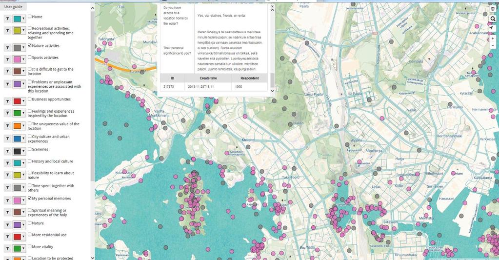
11 Another online tool


12 and a Power report about all popular places by the water

13 Multi-level governance of aquatic environments

14 Marine planning Marine spatial plans Marine plans River basin plans Provisional plan Land use plans Lähde: Swedish Agency for Marine and Water Management 2015
15 Bundesamt für Seeshifffahrt und Hydrographie [ ( )
")
16 MSP incorporating data, governance and stakeholder perspectives Stephen Jay in Transboundary Marine Spatial Planning and International Law, edited by Daud Hassan, Tuomas Kuokkanen and Niko Soininen(2015) p. 181

17 Role of data in MSP MSP requires accurate and comprehensive data regarding charcheristics and interests of the marine area to be planned In the transboundary contexts, data gathering and analysis should should be well coordinated and harmonised.

18 Thank you! Picture: Tuomas Kuokkanen
Evaluation of Spatial Planning as a Tool for Integrated Marine Management Status, Obstacles and Research Gaps
 Evaluation of Spatial Planning as a Tool for Integrated Marine Management Status, Obstacles and Research Gaps Baltic MSP Forum Riga 17.-18. June 2014 A. Morf & A. Grimvall: Swedish Institute for the Marine
Coastal data for Integrated Maritime Policies
 Coastal data for Integrated Maritime Policies LOCHET Corine Shom Name of presentation Protection against erosion and marine flood Name presenter Link between different data scales and Name of presentation
Marine Spatial Planning as an important tool for implementing the MSFD
 Marine Spatial Planning as an important tool for implementing the MSFD Risto Kalliola Tallinn, Nov. 16 th 2012 DEPARTMENT OF GEOGRAPHY AND GEOLOGY University of Turku, Finland Ten principles to provide
Findings and recommendations from Central Baltic case
 W 1/1 Recommendations on transboundary planning from Baltic SCOPE Findings and recommendations from Central Baltic case Ingūna Urtāne Director of Spatial Planning Department of the Ministry of Environmental
SPLAN-Natura Towards an integrated spatial planning approach for Natura th January, 2017 Brussels. Commissioned by DG Environment
 SPLAN-Natura 2000 Towards an integrated spatial planning approach for Natura 2000 Commissioned by DG Environment 17 th January, 2017 Brussels V. Simeonova (Ph.D.) Drivers towards integrating Biodiversity
Identification of maritime spatial planning best practices in the Baltic Sea Region and other EU maritime regions
 Identification of maritime spatial planning best practices in the Baltic Sea Region and other EU maritime regions PLAN BOTHNIA Baltic Sea Region Stakeholder Meeting Jacek Zaucha, Magdalena Matczak Two
INSPIRE a backbone in spatially enabling the digital maritime society in the Baltic Sea region
 Lise Schrøder (AAU), Lena Hallin Pihlatie (SYKE) & Manuel Frias Vega (Helcom) INSPIRE a backbone in spatially enabling the digital maritime society in the Baltic Sea region Agenda The Baltic LINes project
Regional Plan 4: Integrating Ecosystem Services Mapping into Regional Land Use Planning
 Rural-Urban Outlooks: Unlocking Synergies (ROBUST) ROBUST receives funding from the European Union s Horizon 2020 research and innovation programme under grant agreement No 727988.* October 2018 Natural
Advancing Geoscientific Capability. Geological Survey of Finland
 Advancing Geoscientific Capability Geological Survey of Finland GTK in brief The Geological Survey of Finland (GTK) is one of the largest European centres of excellence in assessment, research and the
PLAN BOTHNIA MARE/2009/16
 PLAN BOTHNIA MARE/2009/16 Hermanni Backer Project Manager HELCOM Secretariat Partner Kick-Off Meeting Nordregio, Stockholm December 16 2010 Photo: Elena Bulycheva PLAN BOTHNIA MARE/2009/16 Co-financed
ESTIMATING THE SOCIAL & ENVIRONMENTAL EFFECTS OF ADVENTURE TOURISM AND RECREATION ON CROWN LAND IN BRITISH COLUMBIA
 ESTIMATING THE SOCIAL & ENVIRONMENTAL EFFECTS OF ADVENTURE TOURISM AND RECREATION ON CROWN LAND IN BRITISH COLUMBIA Wolfgang Haider School of Resource and Environmental Mgt. Simon Fraser University Burnaby,
Maritime Spatial Planning in the Baltic Sea Region
 Maritime Spatial Planning in the Baltic Sea Region Talis Linkaits Head of VASAB Secretariat 20 May 2015 Helsinki A cooperation of ministers of the 11 Baltic Sea Region countries responsible for spatial
1. Baltic SCOPE Towards coherence and cross-border solutions in Baltic Maritime Spatial Plans
 NSHC 32th Conference Explanatory Note Dublin, Ireland Item E.2 MSP 21-23 June 2016 Germany Cross border MSP for the EEZ, a case study from the Baltic Sea The Federal Maritime and Hydrographic Agency of
Needs, obstacles and opportunities for environmental justice
 Engagement with urban blue structure in the Helsinki Metropolitan Area: Needs, obstacles and opportunities for environmental justice Timo Assmuth, Arto Viinikka, Leena Kopperoinen, Riikka Paloniemi Finnish
Tackling MSP integration challenges in the BSR
 Towards sustainable governance of Baltic marine space 2015 2018 BALTSPACE Towards sustainable governance of Baltic marine space Tackling MSP integration challenges in the BSR Michael Gilek, Södertörn University,
Mapping Maine s Working Waterfront: for Our Heritage and Economy
 Mapping Maine s Working Waterfront: for Our Heritage and Economy Abstract Mapping Maine s Working Waterfronts is a collaborative project led by the Island Institute that inventories the state s current
Policy-oriented ES-research in Belgium: progress and prospects
 Policy-oriented ES-research in Belgium: progress and prospects Vilm 12.10.2011 Sander Jacobs 1, Wouter Van Reeth², Jan Staes 1 & Patrick Meire 1 1 University of Antwerp, ecosystem management research group
Summary Description Municipality of Anchorage. Anchorage Coastal Resource Atlas Project
 Summary Description Municipality of Anchorage Anchorage Coastal Resource Atlas Project By: Thede Tobish, MOA Planner; and Charlie Barnwell, MOA GIS Manager Introduction Local governments often struggle
Information System as a Tool for Marine Spatial Planning The SmartSea Vision and a Prototype
 Information System as a Tool for Marine Spatial Planning The SmartSea Vision and a Prototype Ari Jolma Marine Research Centre Finnish Environment Institute May 10, 2017 ISESS 2017, Zadar, Croatia Contents
Hydrologic Analysis for Ecosystem Restoration
 Hydrologic Analysis for Ecosystem Restoration Davis, California Objectives: To provide participants with: 1) an understanding of the issues in restoration studies; 2) an overview of Corps policies and
Geospatial workflows and potential applications to the Sustainable Development Goals of countries in West Asia
 Geospatial workflows and potential applications to the Sustainable Development Goals of countries in West Asia Ameer Abdulla, PhD Senior Advisor, European Topic Center for Spatial Analysis, Spain Associate
Brian D. George. GIMS Specialist Ohio Coastal Atlas Project Coordinator and Cartographer. Impacts and Outcomes of Mature Coastal Web Atlases
 Ohio Coastal Atlas Project Brian D. George GIMS Specialist Ohio Coastal Atlas Project Coordinator and Cartographer Ohio Department of Natural Resources Office of Coastal Management Sandusky, OH Impacts
Plan4all (econtentplus project)
") Plan4all (econtentplus project) Karel CHARVAT 1, Tomáš MILDORF 2 1 Help service remote sensing, Ltd., Černoleská 1600, 256 01 Benešov u Prahy, Czech Republic charvat@bnhelp.cz 2 Department of Mathematics
Plan4all (econtentplus project) Karel CHARVAT 1, Tomáš MILDORF 2 1 Help service remote sensing, Ltd., Černoleská 1600, 256 01 Benešov u Prahy, Czech Republic charvat@bnhelp.cz 2 Department of Mathematics
GIS and Coastal Nutrients Luke Cole
 GIS and Coastal Nutrients Luke Cole Human population density has been widely utilized as a valid predictor of terrestrial nitrogen loads into marine systems. As 50% of the world s population lives within
BALANCE WP4: Development of a Baltic Sea marine area management framework. - with key inputs from WP1, WP2 & WP3
 BALANCE WP4: Development of a Baltic Sea marine area management framework - with key inputs from WP1, WP2 & WP3 BALANCE Kick-Off meeting, Copenhagen, 31 Aug-1 Sept 2005 Contents of the presentation: 1.
PLAN BOTHNIA MSP 1/2011 PLAN BOTHNIA. PLAN BOTHNIA short description (document 3/1) PLAN BOTHNIA MSP 1 Pori, Finland, March
 PLAN BOTHNIA MSP 1 Pori, Finland, March") PLAN BOTHNIA Co-Financed Under European Integrated maritime Policy PLAN BOTHNIA short description (document 3/1) PLAN BOTHNIA MSP 1 Pori, Finland, March 7-8 2011 PLAN BOTHNIA MSP 1/2011 Agenda Item 3 Introduction
PLAN BOTHNIA Co-Financed Under European Integrated maritime Policy PLAN BOTHNIA short description (document 3/1) PLAN BOTHNIA MSP 1 Pori, Finland, March 7-8 2011 PLAN BOTHNIA MSP 1/2011 Agenda Item 3 Introduction
TEN-T North Sea-Baltic Corridor improvements. Regional Workshop, 13/09/2016, Poznan, Poland
 TEN-T North Sea-Baltic Corridor improvements Regional Workshop, 13/09/2016, Poznan, Poland Contents Introduction to VASAB, NSB CoRe project and WP4 Group of Activities 4.1. Group of Activities 4.2. Structure
Country Fiche Sweden Updated May 2018
 Country Fiche Sweden Updated May 2018 1. General information 2 the territorial sea (12-nm zone) 70,000 km2 the Exclusive Economic Zone 60,000 km2 the EEZ is limited to the central line between adjacent
Key Indicators for Territorial Cohesion & Spatial Planning Stakeholder Workshop - Project Update. 13 th December 2012 San Sebastián, Basque Country
 Key Indicators for Territorial Cohesion & Spatial Planning Stakeholder Workshop - Project Update 13 th December 2012 San Sebastián, Basque Country Key Aims Explore the use of territorial data in developing
Overview of Methods. Terrestrial areas that are most important for conservation Conservation
 Overview of Methods The goal of the Western Lake Erie Coastal Conservation Vision project (WLECCV) is to define where we should be working locally to optimally achieve regional conservation impact. The
Additional information (material for interactions and analysis chapter) to document 3/1, the PLAN BOTHNIA MSP Assessment
 to document 3/1, the PLAN BOTHNIA MSP Assessment") Co-Financed Under European Integrated Maritime Policy PLAN BOTHNIA MSP 2/2011 MSP Assessment Add 1 PLAN BOTHNIA MSP 2 Uppsala, Sweden June 14-15 2011 Agenda Item 3 PLAN BOTHNIA MSP Assessment Document
Co-Financed Under European Integrated Maritime Policy PLAN BOTHNIA MSP 2/2011 MSP Assessment Add 1 PLAN BOTHNIA MSP 2 Uppsala, Sweden June 14-15 2011 Agenda Item 3 PLAN BOTHNIA MSP Assessment Document
How to integrate maritime cultural heritage into maritime spatial planning?
 2ND SUBMARINER Conference #BetterOff Blue17 Creating synergies for a biobased society How to integrate maritime cultural heritage into maritime spatial planning? Susanne Altvater, s.pro 28.09.2017 #BetterOffBlue17
SustainBaltic FOUR FINALISED ICZM PLANS
 SustainBaltic FOUR FINALISED ICZM PLANS 1. The case characteristics / each ICZM site DEVELOPING SUSTAINABLE TOURISM IN SATAKUNTA S COASTAL ZONE PERSPECTIVE OF LAND USE PLANNING SustainBaltic (CB354) The
ESPON support for Targeted Analyses Ilona Raugze Director
 ESPON support for Targeted Analyses Ilona Raugze Director ESPON EGTC 14 November 2017 ESPON EGTC workshop Targeted Analysis in support of better policy making in cities and regions Inspire policy making
MARITIME SPATIAL PLANNING FOR SUSTAINABLE BLUE ECONOMIES
 MARITIME SPATIAL PLANNING FOR SUSTAINABLE BLUE ECONOMIES Content of newsletter Alternative scenarios for Blue Growth (p. 4) Map based platform to help communication (p. 5) Booklets of marine nature and
Maritime Spatial Planning in the Baltic Sea Region
 Maritime Spatial Planning in the Baltic Sea Region Past, present, perspective Talis Linkaits VASAB Secretariat XIX International Environmental Forum 22 March 2018, Saint Petersburg A cooperation of ministers
Designing Networks of Marine Protected Areas in DFO s Three Atlantic Bioregions
 Designing Networks of Marine Protected Areas in DFO s Three Atlantic Bioregions Presentation for Indigenous Protected Areas Workshop Max Westhead, DFO and Adrian Gerhartz-Abraham, Dalhousie March 29, 2017
An Internet-Based Integrated Resource Management System (IRMS)
") An Internet-Based Integrated Resource Management System (IRMS) Third Quarter Report, Year II 4/1/2000 6/30/2000 Prepared for Missouri Department of Natural Resources Missouri Department of Conservation
An Internet-Based Integrated Resource Management System (IRMS) Third Quarter Report, Year II 4/1/2000 6/30/2000 Prepared for Missouri Department of Natural Resources Missouri Department of Conservation
The Arctic Landscape Conservation Cooperative Conservation Goals
 The Arctic Landscape Conservation Cooperative Conservation Goals Adopted by the Arctic LCC Steering Committee, 24 August 2010 Background : Landscape Conservation Cooperatives and Climate Science Centers
Organizing Inter- and Transdisciplinary Research in TERRECO TERRECO Seminar, Winter term 2009/10
 Organizing Inter- and Transdisciplinary Research in TERRECO TERRECO Seminar, Winter term 2009/10 Prof. Dr. Thomas Köllner Professorship of Ecological Services (PES), University of Bayreuth Goals 1. Learn
HUMAN GEODESY SHAPING A NEW SCIENCE AND PROFESSION FOR THE WORLD OF TOMORROW. Walter Timo de Vries TUM München / Germany
 Presented at the FIG Working Week 2017, May 29 - June 2, 2017 in Helsinki, Finland HUMAN GEODESY SHAPING A NEW SCIENCE AND PROFESSION FOR THE WORLD OF TOMORROW Walter Timo de Vries TUM München / Germany
Country Fiche Estonia
 Country Fiche Estonia Updated October 2017 1. General information Size of internal waters (to the baseline) and territorial sea (12-nm zone from the baseline) approximately 25 200 km 2. Exclusive economic
Cross-border Maritime Spatial Plan for the Black sea - Romania and Bulgaria project
 Cross-border Maritime Spatial Plan for the Black sea - Romania and Bulgaria project in Romania and Bulgaria Plan Presentation A first step in the management of the marine areas of Romania and Bulgaria
Mapping ecosystem services provided by benthic habitats in the European Atlantic Ocean
 Mapping and Assessment Ecosystem Services and Links to Good Environmental Status Mapping ecosystem services provided by benthic habitats in the European Atlantic Ocean Ibon Galparsoro, Angel Borja and
Country Fiche Sweden.
 Country Fiche Sweden 1. General information the territorial sea (12- nm zone) 70,000 km2 the Exclusive Economic Zone 60,000 km2 the EEZ is limited to the central line between adjacent states because the
8 th 12 th Designing a Monitoring Plan Mapping & Analysis (Activities 1 2)
") 8 th 12 th Designing a Monitoring Plan Mapping & Analysis (Activities 1 2) Objectives for All Activities - To be able to define and describe the purpose and uses of topographic maps. - To define rules
8 th 12 th Designing a Monitoring Plan Mapping & Analysis (Activities 1 2) Objectives for All Activities - To be able to define and describe the purpose and uses of topographic maps. - To define rules
Country Fiche Lithuania
 Country Fiche Lithuania Updated June 2018 1. General information The Lithuanian maritime space is delimited by the Decree of the Government of the Republic of Lithuania of 6 December, 2004, No. 1597 and
ADRIPLAN Project Prof. Francesco Musco, IUAV University of Venice
 ADRIPLAN Project Prof. Francesco Musco, IUAV University of Venice msp@iuav.it Riga, Baltic MSP Forum, 17/18 June 2014 Outline The ADRIPLAN Project (DG MARE) Methodological insights Planning Design & interaction
GIS AND COMMUNITY ENGAGEMENT: SOCIOSPATIAL APPROACHES TO RESEARCH AND POLICY
 GIS AND COMMUNITY ENGAGEMENT: SOCIOSPATIAL APPROACHES TO RESEARCH AND POLICY DR. SHEILA LAKSHMI STEINBERG BRANDMAN UNIVERSITY CHAPMAN UNIVERSITY SYSTEM GIS DAY PRESENTATION-UNIVERSITY OF KANSAS, NOVEMBER
Country Fiche Estonia
 Country Fiche Estonia Deleted: October Updated May 2018 Deleted: 7 1. General information Size of internal waters (to the baseline) and territorial sea (12-nm zone from the baseline) approximately 25 200
EAGLE Data Model and Outcomes of HELM (Harmonised European Land Monitoring)
") EAGLE Data Model and Outcomes of HELM (Harmonised European Land Monitoring) Contribution towards better land information harmonisation and INSPIRE compliance EAGLE working group Stephan Arnold, Barbara
EAGLE Data Model and Outcomes of HELM (Harmonised European Land Monitoring) Contribution towards better land information harmonisation and INSPIRE compliance EAGLE working group Stephan Arnold, Barbara
Tua Nylén and Harri Tolvanen. Deliverable D.T3.2.1 Guidelines for harmonising, producing and managing crossborder.
 Tua Nylén and Harri Tolvanen Deliverable D.T3.2.1 Guidelines for harmonising, producing and managing crossborder spatial data Cross-border case 28.7.2017 CONTENTS BACKGROUND... 2 FREQUENTLY USED TERMS...
Marine Spatial Planning in the Baltic Sea Region
 Marine Spatial Planning in the Baltic Sea Region Towards coherence and cross-border solutions in Baltic Maritime Spatial Plans Coordinator & Project manager Dr Ingela Isaksson Swedish Agency for Marine
Outline National legislative & policy context Regional history with ESSIM ESSIM Evaluation Phase Government Integration via RCCOM Regional ICOM Framew
 What MSP Implementation could change in the Maritimes Region Tim Hall, Regional Manager Oceans and Coastal Management Division Ecosystem Management Branch Fisheries and Oceans Canada Maritimes Region BIO
The Danish Maritime Spatial Data Infrastructure (MSDI) Geodata of the Sea
 Geodata of the Sea") MSDI/MSP The Danish Maritime Spatial Data Infrastructure (MSDI) Geodata of the Sea Components of an infrastructure: DATA - metadata, datasets FUNCTIONALITY - spatial data services, web services and other
MSDI/MSP The Danish Maritime Spatial Data Infrastructure (MSDI) Geodata of the Sea Components of an infrastructure: DATA - metadata, datasets FUNCTIONALITY - spatial data services, web services and other
Sandra Lee Pinel, PhD, AICP
 Sandra Lee Pinel, PhD, AICP Exper se: Community, indigenous, and regional planning, applied anthropology, comprehensive local and regional planning, conflict management, case studies, strategic and par"cipatory
Maritime Spatial Planning: Transboundary Cooperation in the Celtic Seas Looking Ahead
 Maritime Spatial Planning: Transboundary Cooperation in the Celtic Seas Looking Ahead Looking ahead MSP in the context of the European Maritime and Fisheries Fund (EMFF) and beyond SIMCelt Final Conference
SAON. Finnish Perspectives
 SAON Finnish Perspectives Challenges and opportunities Kari Laine THULE institute University of Oulu Finnish Perspectives: Challenges and opportunities Northern Long-Term Socio-Ecological Research Platform
The HELCOM Baltic Sea Action Plan and Marine Spatial Planning
 The HELCOM Baltic Sea Action Plan and Marine Spatial Planning Anne Christine Brusendorff Executive Secretary HELCOM The Baltic Sea Our common responsibility. Workshop on Integrated Sea Use management Stockholm
Margarita Stancheva Hristo Stanchev & Robert Young 2. MEDCOAST JUBILEE WORKSHOP May 2015, Iberotel Sarigerme Park, Dalaman, Turkey
 Margarita Stancheva Hristo Stanchev & Robert Young 2 INTRODUCTION: Bulgarian Black Sea coast INTRODUCTION: Increasing pressure on Bulgarian coastal zone In 2011, of the 7 364 570 people that lived in Bulgaria,
The Added Value of Geospatial Data in a Statistical Office. Pedro Diaz Munoz Director Sectoral and Regional Statistics EUROSTAT European Commission
 The Added Value of Geospatial Data in a Statistical Office Pedro Diaz Munoz Director Sectoral and Regional Statistics EUROSTAT European Commission Why integrate Responsibility of all the information we
AS & A2 Geography for OCR. Tailored Courses. Slapton Ley
 AS & A2 Geography for OCR Tailored Courses Slapton Ley Please visit http://www.field-studies-council.org/outdoorclassroom/geography/aqa/ for alternative A-level AQA programmes OVERVIEW Since the assessment
China-ASEAN Advanced Academy on Oceans Law and Governance 7-16 November 2016, NISCSS, Haikou
 China-ASEAN Advanced Academy on Oceans Law and Governance 7-16 November 2016, NISCSS, Haikou Topics to cover Why ocean? The importance of the oceans Why ocean governance? Key concerns affecting the oceans
A Comparison of the Social Valuation of Ecosystem Services in Urban and Rural Contexts
 A Comparison of the Social Valuation of Ecosystem Services in Urban and Rural Contexts Jarrod L. Loerzel College of Charleston Zachary D. Cole University of Florida Presentation Map 1. What is SolVES?
Why care about metropolitan and regional perspectives?
 Metropolitan challenges and solutions Why care about metropolitan and regional perspectives? Irma Karjalainen, Director, Helsinki Region Environmental Services Authority HSY, LUMAT Conference, 25 September
Economic and Social Urban Indicators: A Spatial Decision Support System for Chicago Area Transportation Planning
 Economic and Social Urban Indicators: A Spatial Decision Support System for Chicago Area Transportation Planning Piyushimita Thakuriah (Vonu), P.S. Sriraj, Paul Metaxatos, Inshu Minocha & Tanushri Swarup
Regional Economic Competitiveness Local Comprehensive Planning. An End-of-year Update to the Metropolitan Council Community Development Committee
 Regional Economic Competitiveness Local Comprehensive Planning An End-of-year Update to the Metropolitan Council Community Development Committee 12/21/2015 Regional Economic Competitiveness The ability
Introduction of the Asia-Oceania Global Earth Observation System of Systems (AOGEOSS) GEO Initiative(GI-22 )
 GEO Initiative(GI-22 )") Introduction of the Asia-Oceania Global Earth Observation System of Systems (AOGEOSS) GEO Initiative(GI-22 ) Prof. Xiang ZHOU Institute of Remote Sensing and Digital Earth, CAS 11 May 2017 Kunming, China
Introduction of the Asia-Oceania Global Earth Observation System of Systems (AOGEOSS) GEO Initiative(GI-22 ) Prof. Xiang ZHOU Institute of Remote Sensing and Digital Earth, CAS 11 May 2017 Kunming, China
Application of GIS Technology in Watershed-based Management and Decision Making
 Application of GIS Technology in Watershed-based Management and Decision Making U. Sunday Tim Iowa State University Department of Agricultural and Biosystems Engineering 100 Davidson Hall Email:
MESMA: An integrated tool box to support an ecosystem based spatial management of marine areas
 MESMA: An integrated tool box to support an ecosystem based spatial management of marine areas Stelzenmüller, V., Stamford, T., Vassilopoulou, V., Kastanevakis, S., Vincx, M, Vanaverbeke, J., Rabaut, M.,
Belfairs Academy GEOGRAPHY Fundamentals Map
 YEAR 12 Fundamentals Unit 1 Contemporary Urban Places Urbanisation Urbanisation and its importance in human affairs. Global patterns of urbanisation since 1945. Urbanisation, suburbanisation, counter-urbanisation,
VISION FOR THE FUTURE: Marine Spatial Planning in Belgium
 VISION FOR THE FUTURE: Marine Spatial Planning in Belgium Fanny Douvere, Consultant Intergovernmental Oceanographic Commission UNESCO, Paris, France PlanCoast Conference on Marine Spatial Planning Supetar
Natural Resource Management Strategy. Southern Tasmania. Summary. Natural Resource Management Strategy for Southern Tasmania Summary
 Natural Resource Management Strategy Summary Southern Tasmania 2015 2020 Natural Resource Management Strategy for Southern Tasmania 2015 2020 - Summary i Disclaimer In developing this Strategy, every effort
Compact guides GISCO. Geographic information system of the Commission
 Compact guides GISCO Geographic information system of the Commission What is GISCO? GISCO, the Geographic Information System of the COmmission, is a permanent service of Eurostat that fulfils the requirements
Maritime Spatial Planning in Germany and Mecklenburg-Vorpommern
 Integrated Sea Use Planning Followings the Ecosystem Approach 2.10.08 Maritime Spatial Planning in Germany and Mecklenburg-Vorpommern by Helmuth von Nicolai Spatial Planning Department Ministry of Transport,
GIS Solutions in Natural Resource Management: Balancing the Technical- Political Equation
 GIS Solutions in Natural Resource Management: Balancing the Technical- Political Equation Stan Morain, Editor SUB Gdttlngen 7 208 520 309 98 A14447 0NW0RD PRESS V? % \
Kyoto and Carbon Initiative - the Ramsar / Wetlands International perspective
 Kyoto and Carbon Initiative - the Ramsar / Wetlands International perspective (the thoughts of Max Finlayson, as interpreted by John Lowry) Broad Requirements Guideline(s) for delineating wetlands (specifically,
Recreation Use and Spatial Distribution of Use by Washington Households on the Outer Coast of Washington
 Journal of Park and Recreation Administration Vol. 36 pp. 56 68 2018 https://doi.org/10.18666/jpra-2018-v36-i1-7915 Special Issue Recreation Use and Spatial Distribution of Use by Washington Households
Scenario development for reaching urban and environmental planning integration in the context of climate change*.
 Scenario development for reaching urban and environmental planning integration in the context of climate change*. PhD (cand) Verónica Zagare (TUDelft, ) Dr. Diego Sepúlveda Carmona (TUDelft) September
HydroSpatial II Practical application of INSPIRE in Marine Mapping Data
 HydroSpatial II Practical application of INSPIRE in Marine Mapping Data INSPIRE Conference 30 th June 2011 Carlos Berná Esteban, GIS Analyst, SeaZone carlos.berna-esteban@seazone.com Overview HydroSpatial
Taking the Bite out of Wetlands
 Taking the Bite out of Wetlands Valuing Nature Annual Conference Tim Acott, University of Greenwich Tuesday 18 th October 2016 Manchester Central Complex, M2 3GX The Project Taking the bite out of wetlands:
DELIVERING ECOSYSTEM- BASED MARINE SPATIAL PLANNING IN PRACTICE
 DELIVERING ECOSYSTEM- BASED MARINE SPATIAL PLANNING IN PRACTICE A first assessment for the UK and Ireland January 08 GLOBAL WARMING IMAGES / WWF ABOUT WWF WWF is the world s leading independent conservation
The story of sharing environmental data
 The story of sharing environmental data Kallio, Pyhälahti, Harju, Teiniranta, Lahtinen, Finnish Environment Institute SYKE OKFestival, Finnish Open Data, 18. Sep 2012 Contents Call for environmental knowledge
THE ROLE OF SPATIAL PLANNING IN INTEGRATED COASTAL ZONE MANAGEMENT RECOMMENDATIONS FROM THE INTERREG III B BALTCOAST PROJECT
 THE ROLE OF SPATIAL PLANNING IN INTEGRATED COASTAL ZONE MANAGEMENT RECOMMENDATIONS FROM THE INTERREG III B BALTCOAST PROJECT DISCUSSION PAPER FOR THE TRANSNATIONAL WORKING GROUP DECEMBER 2004 CONTENT 1.
Applications of Geographic Information Systems (GIS) and Remote Sensing (RS) in Marine Spatial Planning
 and Remote Sensing (RS) in Marine Spatial Planning") Ryan Rezendes Dr. August and Dr. Wang NRS 509 Applications of GIS and Remote Sensing Overview and Annotated Bibliography Fall Semester 14 December 2017 Applications of Geographic Information Systems (GIS)
Ryan Rezendes Dr. August and Dr. Wang NRS 509 Applications of GIS and Remote Sensing Overview and Annotated Bibliography Fall Semester 14 December 2017 Applications of Geographic Information Systems (GIS)
BURGAS CASE STUDY: LAND-SEA INTERACTIONS
 BURGAS CASE STUDY: LAND-SEA INTERACTIONS Dr. Margarita Stancheva IO-BAS, Bulgaria Name of presentation CROSS BORDER MARITIME SPATIAL PLANNING IN THE BLACK SEA ROMANIA AND BULGARIA (MARSPLAN BS) Project
MARINE SPATIAL PLANNING & MARINE CADASTRE: CHALLENGES AND ISSUES
 MARINE SPATIAL PLANNING & MARINE CADASTRE: CHALLENGES AND ISSUES Roger Longhorn Secretary General, GSDI Association rlonghorn@gsdi.org Member, IHO Marine SDI Working Group ral@alum.mit.edu Member, UNESCO
Regional stakeholders strategy of Donegal County Council
 Regional stakeholders strategy of Donegal County Council Table of contents The template comprised five steps in the creation of this communication strategy: 1 Starting point. Communication objectives...
How GIS based Visualizations Support Land Use and Transportation Modeling
 How GIS based Visualizations Support Land Use and Transportation Modeling ESRI International Users Conference San Diego, CA - July 23, 2015 Prepared by: Troy Hightower Introduction This presentation will
Pathways. Pathways through the Geography Major
 Pathways through the Major majors may structure their course selections around a sub-field of. Pathways are suggestions for classes in, in related disciplines, and skills training. Each pathway includes
Visualizing Upper Trophic and Ecosystem Modeling Outputs with EverVIEW to Inform the Decision Process in Coastal Louisiana.
 Visualizing Upper Trophic and Ecosystem Modeling Outputs with EverVIEW to Inform the Decision Process in Coastal Louisiana 2012 Master Plan Craig Conzelmann Carol Parsons Richards Kevin Suir COMPREHENSIVE
BURGAS CASE STUDY: LAND-SEA INTERACTIONS. Dr. Margarita Stancheva
 BURGAS CASE STUDY: LAND-SEA INTERACTIONS Dr. Margarita Stancheva Name of presentation NEED FOR COHERENCE BETWEEN LAND AND SEA ACTIVITIES Name presenter Burgas is the fourth largest city in Bulgaria and
ESPON 2020 Cooperation Programme. Anneloes van Noordt MC-member Belgium
 ESPON 2020 Cooperation Programme Anneloes van Noordt MC-member Belgium Anneloes.vannoordt@vlaanderen.be Outline ESPON 2020 Cooperation Programme Applied Research Targeted Analysis Database & Tools Outreach
GMES and AFRICA Support Programme 1st technical committee meeting
 GMES and AFRICA Support Programme 1st technical committee meeting Developing an Earth Observation Operational Application for Coastal Ecosystems Mapping, Monitoring and Assessment of the Northern African
Protected Areas Information Management Systems and Challenges in Korea Hong, Suk-Hwan. Pusan National University
 1 Protected Areas Information Management Systems and Challenges in Korea 2012. 3. 28. Hong, Suk-Hwan Pusan National University Part 1 Protected Areas Database of Korea Part 1. Protected Areas Database
Developing Quality of Life and Urban- Rural Interactions in BSR
 Developing Quality of Life and Urban- Rural Interactions in BSR Sakari Saarinen Union of the Baltic Cities, Commission on Environment Seminar on Quality of Life in Small Communities, 27 May 2010, Kärdla,
ROLE OF SPATIAL PLANNING TOOLS AT MESO-SCALE IN THE MANAGEMENT OF NATURAL RESOURCES, LESSONS LEARNT FROM AFRICAN COUNTRIES
 6th Nov, 2012 ROLE OF SPATIAL PLANNING TOOLS AT MESO-SCALE IN THE MANAGEMENT OF NATURAL RESOURCES, LESSONS LEARNT FROM AFRICAN COUNTRIES Masoom Hamdard Environmental Planning and Assessment for Adaptation
THE USE OF GEOSPATIAL DATA TO SUPPORT VULNERABILITY MAPPING OF THE OREGON COAST. Kelvin Raiford MS Candidate Geography Department of Geosciences
 THE USE OF GEOSPATIAL DATA TO SUPPORT VULNERABILITY MAPPING OF THE OREGON COAST Kelvin Raiford MS Candidate Geography Department of Geosciences INTRODUCTION This study is an outcome of the project Geospatial
The Baltic Sea Region Maritime Spatial Planning Data Expert Sub-group. First Report 2015/2016/
 The Baltic Sea Region Maritime Spatial Planning Data Expert Sub-group First Report 2015/2016/2017 21.04.2017. Contents 1. Glossary 2 2. Introduction. 3 3. MSP Data. 5 3.1. Input Data. 5 3.2 Output Data.
Public Participatory GIS (ppgis), training & webgis in Mare Nostrum. Anna Spiteri, IRMCo Haifa, Israel, 5th March 2013
, training & webgis in Mare Nostrum. Anna Spiteri, IRMCo Haifa, Israel, 5th March 2013") Public Participatory GIS (ppgis), training & webgis in Mare Nostrum Anna Spiteri, IRMCo Haifa, Israel, 5th March 2013 What is ppgis? Why do we need it? Who participates? Where do we do it? When do we do
Public Participatory GIS (ppgis), training & webgis in Mare Nostrum Anna Spiteri, IRMCo Haifa, Israel, 5th March 2013 What is ppgis? Why do we need it? Who participates? Where do we do it? When do we do