International Journal of Advance Research in Engineering, Science & Technology
|
|
|
- Easter Ward
- 5 years ago
- Views:
Transcription


1 Impact Factor (SJIF): International Journal of Advance Research in Engineering, Science & Technology e-issn: , p-issn: Volume 3, Issue 7, July-2016 Water Supply Network Study of Sanand using Remote Sensing and GIS Techniques Parth R. Patel 1, N M Joshipura 2, Dr. Indraprakash 3 1 Student, LE Morbi 2 Assistant Professor at Shantilal shah Engineering College,Bhavnagar 3 Faculty BISAG, Gandhinagar Abstract Water distribution systems constitute a vital part of civil infrastructure. An increasing demand for water due to population growth, industrial development and improvement of economic require management of water transfer and improve operation of distributed network systems. Design of water supply systems is one of this issues that can be mapping and analyses using GIS and RS techniques. The purpose of a water distribution system is to ensure the supply of water to users at spatter of urban expansion over the demographic change and land use modifications has also indicated that urban growth has mainly taken place linearly along the major roads in the study area. Keywords- Water supply Network, GIS, Remote sensing, EPANET, I. INTRODUCTION Water supply system (WSS) is a complex system that integrates several spatial features. Water supply systemic a structure of collection, storage, and distribution of the water for homes, commercial establishments, industry, and irrigation and for other purposes. In all cases, the water must fulfill both quality and quantity requirements. Design of the water supply system is related with the location and storage capacity of tank. Geographical Information System (GIS) is help to prepare and visualize the entire water supply network from source to household. The supplied water should be good in quality and sufficient in quantity. II. TYPE WATER DISTRIBUTION SYSTEM (1) RADIAL SYSTEM The area is divided into the different zones in this system. Then the water is pumped to the distribution reservoir from the main source as shown in fig. Fig. 1: Radial System (2) Grid Iron System This system is more suitable for the cities which have the rectangular layout. In this system, the main and branch pipes are laid in rectangles. 97
2 Fig.2: Grid Iron System (3) Ring System Fig.3: Ring System In this system, the main supply pipes are laid on the peripheral roads and branch pipes are out from the main pipes. (4) Dead End System This system is more suitable for the old cities which having no definite pattern of roads. The planning of the water supply network is mainly depending on the population growth.. In this study, also discuss the basic concept of Remote Sensing and Geographic Information System. Remote Sensing is the process of get the information of any object without coming into physical contact 98
3 with the objects. After taking the images of the objects, important information is provided regarding the object. GIS play a major role by providing the linkage between the available technology and information domain. Fig.4: Dead End System III. NEED OF THIS STUDY The population is increased in urban area and also in rural. There is done the large development in this area. So that water demand is increased for residential, industrial and other purposes. As per IS code 1172:1993, the water requirement for rural area is 100 plod and for urban area is 135 plod. In this area, the water is supplied as per 70 lpcd. That s why existing water distribution system is to be analyzed. IV. SCOPE OF STUDY The assessment of existing water supply system will help in understanding the water distribution requirement of this area for the better utilization and management of water. GIS based assessment of the Water Supply System will give the precise result. By using the EPANET software, the results can be obtained accurately with saving time. The modification of WSS will be easily done, if require. 99

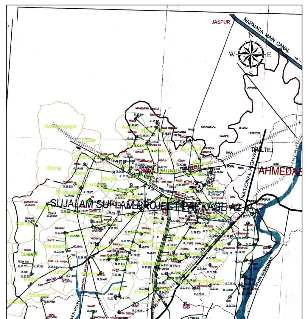
4 1.4 OBJECTIVES OF STUDY Evaluation of existing water supply system of Sanand taluka using geoinformatics techniques and EPANET software. Suggestions for the modifications of water supply system considering the present and future requirement of the study area. 4.1 Study Area In the Present study, the study area is taken Sanand, Gujarat. Sanand is located In Ahmedabad district. Sanand is Larger Talukas in Sujalam Suflam Water Supply A-2 Scheme. 4.2 Location Sanand East (Longitude) to North (Latitude) on the world map. Geographical area of the talukas is 2,163, 48 sq.km. sanand has an average elevation of 38 meters (124 feet). The city is north-central-east Gujarat. The 6230 km 2 area around sanand is a city and a municipality in Ahmedabad district. METHODOLOGY Review of the literature and selection of study area. Collection of the data from government organisations such as GWSSB and 100

5 BISAG like population data, water demand data, road network data, land use/land covers data, existing water distribution map etc. Preparation of various thematic layers such as land use map, road network map, soil map, slope map by using Remote Sensing and GIS. Overlaying of various thematic layers for analysis. By input the data like elevation, length of pipe, base demand at each node, diameter of pipe, the results such as velocity, head loss in pipe, pressure at each node are obtained from EPANET Analysis of spatial data (thematic layers) and non-spatial data (results of EPANET. Suggestion of modification of existing water supply system Satellite image: Land Use/Land Cover Map Land cover map shows that how much of area is covered by forests, water body,road, agriculture etc. 101


6 Land use shows that how people use the land for different purposes. Land use map is related with the socio-economic activity such as water network, parking, garden and school etc. Land use map is used to identify the existing condition and future development of that particular area. Land Use/Land Cover Map is very useful in planning of the water supply network. Population data: 102
7 103
8 5.4 EPANET software: EPANET is a computer program that performs extended period simulation of hydraulic and water quality behavior within pressurized pipe networks. A network consists of pipes, nodes (pipe junctions), pumps, valves and storage tanks or reservoirs. EPANET tracks the flow of water in each 104

9 pipe, the pressure at each node, the height of water in each tank, and the concentration of a chemical species throughout the network during a simulation period comprised of multiple time steps. Elevation Length of Pipe Dia. of Pipe Base Demand EPANET Velocity Head loss Pressure Water quality INPUT OUTPUT Pipe report: Pipes are links that convey water from one point in the network to another. EPANETassumes that all pipes are full at all times. Flow direction is from the end at higher hydraulic head (internal energy perweight of water) to that at lower head. The principal hydraulic input parameters for pipes are: start and end nodes diameter length roughness coefficient (for determining head loss) status (open, closed, or contains a check valve) The hydraulic head lost by water flowing in a pipe due to friction with the pipe Wall scan be computed using one of three different formulas: Hazen-Williams formula Darcy-Weisbach formula Chezy-Manning formula 105
10 The Hazen-Williams formula is the most commonly used head loss formula.it cannot be used for liquids other than water and was originally developed for turbulent flow only. The Darcy-Weisbach formula is the most theoretically correct. It applies over all flow regimes and to all liquids. The Cheesy-Manning formula is morecommonly used for open channel flow. Table Pipe Head loss Formula Table Roughness Coefficients SUMMARY 106
11 The assessment of Water Supply System is carried out for three zones using Goo informatics technology and EPANET software. The population and water demand are estimated. The various thematic maps such as land use, road network, slope and soil maps are generated in Arc map. The geo-referencing and overlaying of these thematic maps are carried out. The inputs such as elevation of nodes and length of pipes are recorded from the Google earth image. These data used in this software for the analysis of pressure and head loss. The results such as pressure and head loss for Telav zone, Kunvar zone and Nidhrad zone are obtained using EPANET software. The outcome results for these three zones are analysed. The unit head loss for the Telav zone is compared for the water supply of 70 lpcd and 100 lpcd. Comparison of head loss: CONCLUSION In this thesis, the main focus is to check the adequacy of the existing Water Supply System. At the end of analysis it was found that the pressures at all junctions are adequate enough to provide water in the case of 70 lpcd water supply. But when we increased the water supply up to 100 lpcd that time the pressures at all junctions are reduced and head loss in all pipes are increased. Thus we can conclude that before supply the 100 lpcd water, there should be increased the diameter of pipes. Thesuggestions for the modification of diameter of pipes for these three zones are shown table 5.13, 5.14, This study would help to the engineers as this process is fast. REFERENCES [1] Ashrafuzzaman Pramanik, et al,2013: Urban Water Supply Network Analysis: A Case Study on Pabna Municipality, Bangladesh, International Journal of Advanced Research [2] Brinda H. Dave, et al, 2015: Continuous Water Distribution Network Analysis Using Geo-informatics Technology and EPANET in Gandhinagar City, Gujarat, India International Journal of Scientific & Engineering Research [3] Dhara J. Surani, et al,2015: Digitizing Water Distribution Network and Topography Mapping from Digital Elevation Model (DEM) using 3D Analyst & Spatial Analyst International Journal for Innovative Research in Science &Technology [4] Khadri, et al,2014: Urban Water Supply Systems - A Case Study On Water Network Distribution in Chalisgaon City in Dhule District Maharashtra Using Remote Sensing & GIS IOSR Journal of Mechanical and Civil Engineering [5] Sundararaman,et al,2012: Urban Hydrology - A Case Study On Water Supply And Sewage Network For Madurai Region, Using Remote Sensing &GIS, International Journal of Engineering and Science [6] EPANET 2, Users Manual, Lewis A. Rossman, Water Supply and Water 107
12 Resources Division, National Risk Management Research Laboratory, Cincinnati, OH 45268, September 2000 [7] S. K. Garg, Water Supply Engineering, Environmental Engineering Vol. 1, New Delhi, 2010 [8] [9] Vipin Yadav, et al,2015: Assess the water distribution network using EPANET International Research Journal of Engineering and Technology, vol. 02, Issue 08 [10] A.M. MALEK, Water and Waste Water Engineering [11] A.E. Adeniran, et al,2013: An EPANET Analysis of Water Distribution Network of the University of Lagos, Nigeria, Journal of Engineering Research, Volume 18 No. 2 June 2013 [12] B Bhatta; Remote Sensing and GIS text book, Oxford University 108
Urban Hydrology - A Case Study On Water Supply And Sewage Network For Madurai Region, Using Remote Sensing & GIS Techniques
 RESEARCH INVENTY: International Journal of Engineering and Science ISBN: 2319-6483, ISSN: 2278-4721, Vol. 1, Issue 8 (November 2012), PP 07-12 www.researchinventy.com Urban Hydrology - A Case Study On
spatial water demand (population density) spatial junctions distribution (building density) digital elevation map
 spatial junctions distribution (building density) digital elevation map") SYSTEM ID: WDS-Designer NARRATIVE DESCRIPTION With the WDS Designer a tool for the algorithmic generation of synthetic water distribution systems (swds) based on GIS data was presented (Sitzenfrei et al.,
SYSTEM ID: WDS-Designer NARRATIVE DESCRIPTION With the WDS Designer a tool for the algorithmic generation of synthetic water distribution systems (swds) based on GIS data was presented (Sitzenfrei et al.,
URBAN WATERSHED RUNOFF MODELING USING GEOSPATIAL TECHNIQUES
 URBAN WATERSHED RUNOFF MODELING USING GEOSPATIAL TECHNIQUES DST Sponsored Research Project (NRDMS Division) By Prof. M. GOPAL NAIK Professor & Chairman, Board of Studies Email: mgnaikc@gmail.com Department
FLOODPLAIN MAPPING OF RIVER KRISHNANA USING HEC-RAS MODEL AT TWO STREACHES NAMELY KUDACHI AND UGAR VILLAGES OF BELAGAVI DISTRICT, KARNATAKA
 FLOODPLAIN MAPPING OF RIVER KRISHNANA USING HEC-RAS MODEL AT TWO STREACHES NAMELY KUDACHI AND UGAR VILLAGES OF BELAGAVI DISTRICT, KARNATAKA Sandhyarekha 1, A. V. Shivapur 2 1M.tech Student, Dept. of and
DEVELOPMENT OF FLOOD HAZARD VULNERABILITY MAP FOR ALAPPUZHA DISTRICT
 DEVELOPMENT OF FLOOD HAZARD VULNERABILITY MAP FOR ALAPPUZHA DISTRICT Ciya Maria Roy 1, Elsa Manoj 2, Harsha Joy 3, Sarin Ravi 4, Abhinanda Roy 5 1,2,3,4 U.G. Student, Department of Civil Engineering, MITS
Assessment of Unaccounted-for Water in Municipal Water Networks Using GIS and Modeling
 24 Assessment of Unaccounted-for Water in Municipal Water Networks Using GIS and Modeling Homayoun Motiee, Ali Motiei, Ahmad Hejranfar and M.Reza Delavar This chapter presents a study to calculate Unaccounted-for
Planning Road Networks in New Cities Using GIS: The Case of New Sohag, Egypt
 Planning Road Networks in New Cities Using GIS: The Case of New Sohag, Egypt Mostafa Abdel-Bary Ebrahim, Egypt Ihab Yehya Abed-Elhafez, Kingdom of Saudi Arabia Keywords: Road network evaluation; GIS, Spatial
VENUS INTERNATIONAL COLLEGE OF TECHNOLOGY
 VENUS INTERNATIONAL COLLEGE OF TECHNOLOGY DEPARTMENT OF E&C ENGINEERING A REPORT ON INDUSTRIAL VISIT AT BISAG, GANDHINAGAR PROFILE: BISAG provides specialized services and solutions in implementing mapbased
EXPLORING THE FUTURE WATER INFRASTRUCTURE OF CITIES
 EXPLORING THE FUTURE WATER INFRASTRUCTURE OF CITIES Eng. Arlex Sanchez Torres PhD. R.K. Price PhD. Z. Vojinovic Jan 24 th - 2011 The future of urban water: Solutions for livable and resilient cities SWITCH
International Journal of Advance Engineering and Research Development
 Scientific Journal of Impact Factor (SJIF): 4.72 International Journal of Advance Engineering and Research Development Volume 4, Issue 5, May -2017 Watershed Delineation of Purna River using Geographical
SITE SELECTION FOR NEW DESALINATION PLANT AND PLANNING AN OPTIMAL WATER DISTRIBUTION NETWORK IN TUTICORIN TALUK
 SITE SELECTION FOR NEW DESALINATION PLANT AND PLANNING AN OPTIMAL WATER DISTRIBUTION NETWORK IN TUTICORIN TALUK *Miss.V.Sahana Devi, **Mrs.G.Devi. *PG student: Department of Civil Engineering, **Assistant
A Remote Sensing and GIS approach to trace the Densification in Residential Areas
 A Remote Sensing and GIS approach to trace the Densification in Residential Areas Valliappan AL Assistant Professor, School of Planning and Architecture, Vijayawada, India. Date:11/03/2015 What is Densification?
River Inundation and Hazard Mapping a Case Study of North Zone Surat City
 River Inundation and Hazard Mapping a Case Study of North Zone Surat City Patel Chandresh G, Assistant Professor, Ganpat University, Kherva Dr.P.J. Gundaliya, Associate Professor, LDCE, Ahmedabad Abstract:
Abstract: Contents. Literature review. 2 Methodology.. 2 Applications, results and discussion.. 2 Conclusions 12. Introduction
 Abstract: Landfill is one of the primary methods for municipal solid waste disposal. In order to reduce the environmental damage and to protect the public health and welfare, choosing the site for landfill
Module - 3 GIS MAPPING, MIS AND GIS UNDER RAY
 Module - 3 1 GIS MAPPING, MIS AND GIS MIS INTEGRATION UNDER RAY Role of GIS & MIS under RAY Under the scheme, two step implementation strategy has been adopted i.e. preparation of SFCPoAs on whole city
PRESENTATION OUTLINE. FIG Working Week INTRODUCTION 2.0 LITERATURE REVIEW 3.0 RESEARCH METHODOLOGY 4.0 RESULTS AND DISCUSSION
 Geospatial Techniques in Water Distribution Network Mapping and Modelling in Warri Port Complex (Nigeria) PRESENTED BY Henry Agbomemeh AUDU 1, Nigeria and Jacob Odeh EHIOROBO 2, Nigeria PRESENTATION OUTLINE
INTERNATIONAL JOURNAL OF GEOMATICS AND GEOSCIENCES Volume 7, No 1, 2016
 INTERNATIONAL JOURNAL OF GEOMATICS AND GEOSCIENCES Volume 7, No 1, 2016 Copyright by the authors - Licensee IPA- Under Creative Commons license 3.0 Research article ISSN 0976 4380 Urban sprawl and urban
Remote Sensing and GIS Applications for Hilly Watersheds SUBASHISA DUTTA DEPARTMENT OF CIVIL ENGINEERING IIT GUWAHATI
 Remote Sensing and GIS Applications for Hilly Watersheds SUBASHISA DUTTA DEPARTMENT OF CIVIL ENGINEERING IIT GUWAHATI Deciding Alternative Land Use Options in a Watershed Using GIS Source: Anita Prakash
VILLAGE INFORMATION SYSTEM (V.I.S) FOR WATERSHED MANAGEMENT IN THE NORTH AHMADNAGAR DISTRICT, MAHARASHTRA
 FOR WATERSHED MANAGEMENT IN THE NORTH AHMADNAGAR DISTRICT, MAHARASHTRA") VILLAGE INFORMATION SYSTEM (V.I.S) FOR WATERSHED MANAGEMENT IN THE NORTH AHMADNAGAR DISTRICT, MAHARASHTRA Abstract: The drought prone zone in the Western Maharashtra is not in position to achieve the agricultural
VILLAGE INFORMATION SYSTEM (V.I.S) FOR WATERSHED MANAGEMENT IN THE NORTH AHMADNAGAR DISTRICT, MAHARASHTRA Abstract: The drought prone zone in the Western Maharashtra is not in position to achieve the agricultural
Fluids Engineering. Pipeline Systems 2. Course teacher Dr. M. Mahbubur Razzaque Professor Department of Mechanical Engineering BUET
 COURSE NUMBER: ME 423 Fluids Engineering Pipeline Systems 2 Course teacher Dr. M. Mahbubur Razzaque Professor Department of Mechanical Engineering BUET 1 SERIES PIPE FLOW WITH PUMP(S) 2 3 4 Colebrook-
WATER DISTRIBUTION NETWORKS
 WATER DISTRIBUTION NETWORKS CE 370 1 Components of Water Supply System 2 1 Water Distribution System Water distribution systems are designed to adequately satisfy the water requirements for a combinations
Vulnerability of Flood Hazard in Selected Ayeyarwady Delta Region, Myanmar
 Vulnerability of Flood Hazard in Selected Ayeyarwady Delta Region, Myanmar Khin Thandar Win Department of Civil Engineering Nilar Aye Department of Civil Engineering Kyaw Zaya Htun Department of Remote
FLOOD HAZARD MAPPING OF DHAKA-NARAYANGANJ-DEMRA (DND) PROJECT USING GEO-INFORMATICS TOOLS
 PROJECT USING GEO-INFORMATICS TOOLS") FLOOD HAZARD MAPPING OF DHAKA-NARAYANGANJ-DEMRA (DND) PROJECT USING GEO-INFORMATICS TOOLS Md. Aminul Islam MEE07178 Supervisor: Prof. Kuniyoshi TAKEUCHI ABSTRACT Dhaka-Narayanganj-Demra (DND) Project is
FLOOD HAZARD MAPPING OF DHAKA-NARAYANGANJ-DEMRA (DND) PROJECT USING GEO-INFORMATICS TOOLS Md. Aminul Islam MEE07178 Supervisor: Prof. Kuniyoshi TAKEUCHI ABSTRACT Dhaka-Narayanganj-Demra (DND) Project is
Review of pipe flow: Friction & Minor Losses
 ENVE 204 Lecture -1 Review of pipe flow: Friction & Minor Losses Assist. Prof. Neslihan SEMERCİ Marmara University Department of Environmental Engineering Important Definitions Pressure Pipe Flow: Refers
Saudi Journal of Engineering and Technology. DOI: /sjeat ISSN (Print)
") DOI:10.21276/sjeat.2017.2.3.1 Saudi Journal of Engineering and Technology Scholars Middle East Publishers Dubai, United Arab Emirates Website: http://scholarsmepub.com/ ISSN 2415-6272 (Print) ISSN 2415-6264
DOI:10.21276/sjeat.2017.2.3.1 Saudi Journal of Engineering and Technology Scholars Middle East Publishers Dubai, United Arab Emirates Website: http://scholarsmepub.com/ ISSN 2415-6272 (Print) ISSN 2415-6264
International Journal of Advancements in Research & Technology, Volume 2, Issue 7, July ISSN
 International Journal of Advancements in Research & Technology, Volume 2, Issue 7, July-2013 34 Remote Sensing & GIS Tools for Urban Studies in Akola city, Maharashtra. Khadri, S.F.R Chaitanya Pande and
Hydrologic Modelling of the Upper Malaprabha Catchment using ArcView SWAT
 Hydrologic Modelling of the Upper Malaprabha Catchment using ArcView SWAT Technical briefs are short summaries of the models used in the project aimed at nontechnical readers. The aim of the PES India
Ground Water Potential Mapping in Chinnar Watershed (Koneri Sub Watershed) Using Remote Sensing & GIS
 Using Remote Sensing & GIS") Ground Water Potential Mapping in Chinnar Watershed (Koneri Sub Watershed) Using Remote Sensing & GIS T.Velmurugan 1 Dr.D.Srinivasan 2 1 Assistant professor/civil, Roever Engineering College, Perambalur.
Ground Water Potential Mapping in Chinnar Watershed (Koneri Sub Watershed) Using Remote Sensing & GIS T.Velmurugan 1 Dr.D.Srinivasan 2 1 Assistant professor/civil, Roever Engineering College, Perambalur.
3301 East 120 th Avenue Assited Living & Memory Care
 UTILITY REPORT FOR 3301 East 120 th Avenue Assited Living & Memory Care 1 st Submittal January 23, 2016 2 nd Submittal March 04, 2016 Prepared for: 3301 E. 120 th Ave, LLC. 8200 E. Maplewood Ave., Suite
PUMPING STATION SCHEDULING FOR WATER DISTRIBUTION NETWORKS IN EPANET
 U.P.B. Sci. Bull., Series D, Vol. 77, Iss., 05 ISSN 454-58 PUMPING STATION SCHEDULING FOR WATER DISTRIBUTION NETWORKS IN EPANET Sanda-Carmen GEORGESCU, Andrei-Mugur GEORGESCU Pumping station scheduling
The Darcy-Weisbach Jacobian and avoiding zero flow failures in the Global Gradient Algorithm for the water network equations
 The Darcy-Weisbach Jacobian and avoiding zero flow failures in the Global Gradient Algorithm for the water network equations by Elhay, S. and A.R. Simpson World Environmental & Water Resources Congress
Abstract: About the Author:
 REMOTE SENSING AND GIS IN LAND USE PLANNING Sathees kumar P 1, Nisha Radhakrishnan 2 1 1 Ph.D Research Scholar, Department of Civil Engineering, National Institute of Technology, Tiruchirappalli- 620015,
FLOOD HAZARD AND RISK ASSESSMENT IN MID- EASTERN PART OF DHAKA, BANGLADESH
 FLOOD HAZARD AND RISK ASSESSMENT IN MID- EASTERN PART OF DHAKA, BANGLADESH Muhammad MASOOD MEE07180 Supervisor: Prof. Kuniyoshi TAKEUCHI ABSTRACT An inundation simulation has been done for the mid-eastern
CHANGES IN VIJAYAWADA CITY BY REMOTE SENSING AND GIS
 International Journal of Civil Engineering and Technology (IJCIET) Volume 8, Issue 5, May 2017, pp.217 223, Article ID: IJCIET_08_05_025 Available online at http://www.ia aeme.com/ijciet/issues.asp?jtype=ijciet&vtyp
International Journal of Intellectual Advancements and Research in Engineering Computations
 ISSN:2348-2079 Volume-5 Issue-2 International Journal of Intellectual Advancements and Research in Engineering Computations Agricultural land investigation and change detection in Coimbatore district by
Transactions on Information and Communications Technologies vol 18, 1998 WIT Press, ISSN
 STREAM, spatial tools for river basins, environment and analysis of management options Menno Schepel Resource Analysis, Zuiderstraat 110, 2611 SJDelft, the Netherlands; e-mail: menno.schepel@resource.nl
THE 3D SIMULATION INFORMATION SYSTEM FOR ASSESSING THE FLOODING LOST IN KEELUNG RIVER BASIN
 THE 3D SIMULATION INFORMATION SYSTEM FOR ASSESSING THE FLOODING LOST IN KEELUNG RIVER BASIN Kuo-Chung Wen *, Tsung-Hsing Huang ** * Associate Professor, Chinese Culture University, Taipei **Master, Chinese
SPRINGVILLE CITY, UTAH PRESSURE IRRIGATION SYSTEM DRAFT. MASTER PLAN & CAPITAL FACILITIES PLAN For the WEST FIELDS. February 11, 2014.
 SPRINGVILLE CITY, UTAH PRESSURE IRRIGATION SYSTEM MASTER PLAN & CAPITAL FACILITIES PLAN For the WEST FIELDS February 11, 2014 Prepared by: J-U-B ENGINEERS, INC. 240 West Center Street, Suite 200 Orem,
![)UDQFR54XHQWLQ(DQG'tD]'HOJDGR&](/thumbs/95/125846872.jpg ")UDQFR54XHQWLQ(DQG'tD]'HOJDGR&") &21&(37,21$1',03/(0(17$7,212)$1+
&21&(37,21$1',03/(0(17$7,212)$1+ SPRINGVILLE CITY, UTAH
 SPRINGVILLE CITY, UTAH PRESSURE IRRIGATION SYSTEM MASTER PLAN & CAPITAL FACILITIES PLAN For the WEST FIELDS February 11, 2014 Adopted May 20, 2014 Prepared by: J-U-B ENGINEERS, INC. 240 West Center Street,
Use of Geospatial data for disaster managements
 Use of Geospatial data for disaster managements Source: http://alertsystemsgroup.com Instructor : Professor Dr. Yuji Murayama Teaching Assistant : Manjula Ranagalage What is GIS? A powerful set of tools
USING GIS CARTOGRAPHIC MODELING TO ANALYSIS SPATIAL DISTRIBUTION OF LANDSLIDE SENSITIVE AREAS IN YANGMINGSHAN NATIONAL PARK, TAIWAN
 CO-145 USING GIS CARTOGRAPHIC MODELING TO ANALYSIS SPATIAL DISTRIBUTION OF LANDSLIDE SENSITIVE AREAS IN YANGMINGSHAN NATIONAL PARK, TAIWAN DING Y.C. Chinese Culture University., TAIPEI, TAIWAN, PROVINCE
GIS = Geographic Information Systems;
 What is GIS GIS = Geographic Information Systems; What Information are we talking about? Information about anything that has a place (e.g. locations of features, address of people) on Earth s surface,
DEVELOPMENT OF GEO-SPATIAL MAPS FOR MAINTENANCE OF WATER SUPPLY SCHEMES
 DEVELOPMENT OF GEO-SPATIAL MAPS FOR MAINTENANCE OF WATER SUPPLY SCHEMES P. Mariappan 1, A. Raja Jeyachandra Bose 2, P. Alex Praveen 3, S. Sreechanth 3 and T. R. Neelakantan 4 1 TWAD Board, 6A,Balasubramanian
ISSUES AND APPROACHES TO COUPLING GIS TO AN IRRIGATION DISTRIBUTION NETWORK AND SEEPAGE LOSS MODELS ABSTRACT
 ISSUES AND APPROACHES TO COUPLING GIS TO AN IRRIGATION DISTRIBUTION NETWORK AND SEEPAGE LOSS MODELS Yanbo Huang 1, Milton Henry 2, David Flahive 3, Guy Fipps 4 ABSTRACT Geographic Information Systems (GIS)
Integrating Geographical Information Systems (GIS) with Hydrological Modelling Applicability and Limitations
 with Hydrological Modelling Applicability and Limitations") Integrating Geographical Information Systems (GIS) with Hydrological Modelling Applicability and Limitations Rajesh VijayKumar Kherde *1, Dr. Priyadarshi. H. Sawant #2 * Department of Civil Engineering,
Integrating Geographical Information Systems (GIS) with Hydrological Modelling Applicability and Limitations Rajesh VijayKumar Kherde *1, Dr. Priyadarshi. H. Sawant #2 * Department of Civil Engineering,
Chapter (3) Water Flow in Pipes
 Water Flow in Pipes") Chapter (3) Water Flow in Pipes Water Flow in Pipes Bernoulli Equation Recall fluid mechanics course, the Bernoulli equation is: P 1 ρg + v 1 g + z 1 = P ρg + v g + z h P + h T + h L Here, we want to study
Chapter (3) Water Flow in Pipes Water Flow in Pipes Bernoulli Equation Recall fluid mechanics course, the Bernoulli equation is: P 1 ρg + v 1 g + z 1 = P ρg + v g + z h P + h T + h L Here, we want to study
INTERNATIONAL JOURNAL OF PURE AND APPLIED RESEARCH IN ENGINEERING AND TECHNOLOGY
 INTERNATIONAL JOURNAL OF PURE AND APPLIED RESEARCH IN ENGINEERING AND TECHNOLOGY A PATH FOR HORIZING YOUR INNOVATIVE WORK SPECIAL ISSUE FOR NATIONAL LEVEL CONFERENCE "SUSTAINABLE TECHNOLOGIES IN CIVIL
An overview of the Hydraulics of Water Distribution Networks
 An overview of the Hydraulics of Water Distribution Networks June 21, 2017 by, P.E. Senior Water Resources Specialist, Santa Clara Valley Water District Adjunct Faculty, San José State University 1 Outline
URBAN CHANGE DETECTION OF LAHORE (PAKISTAN) USING A TIME SERIES OF SATELLITE IMAGES SINCE 1972
 USING A TIME SERIES OF SATELLITE IMAGES SINCE 1972") URBAN CHANGE DETECTION OF LAHORE (PAKISTAN) USING A TIME SERIES OF SATELLITE IMAGES SINCE 1972 Omar Riaz Department of Earth Sciences, University of Sargodha, Sargodha, PAKISTAN. omarriazpk@gmail.com ABSTRACT
URBAN CHANGE DETECTION OF LAHORE (PAKISTAN) USING A TIME SERIES OF SATELLITE IMAGES SINCE 1972 Omar Riaz Department of Earth Sciences, University of Sargodha, Sargodha, PAKISTAN. omarriazpk@gmail.com ABSTRACT
a system for input, storage, manipulation, and output of geographic information. GIS combines software with hardware,
 Introduction to GIS Dr. Pranjit Kr. Sarma Assistant Professor Department of Geography Mangaldi College Mobile: +91 94357 04398 What is a GIS a system for input, storage, manipulation, and output of geographic
GIS Geographical Information Systems. GIS Management
 GIS Geographical Information Systems GIS Management Difficulties on establishing a GIS Funding GIS Determining Project Standards Data Gathering Map Development Recruiting GIS Professionals Educating Staff
Monitoring and Temporal Study of Mining Area of Jodhpur City Using Remote Sensing and GIS
 Monitoring and Temporal Study of Mining Area of Jodhpur City Using Remote Sensing and GIS S. K Yadav 1, S. L Borana 2 1,2 Scientist, Remote Sensing Group, DL, Jodhpur-342011, Rajasthan, India ---------------------------------------------------------------------***---------------------------------------------------------------------
Developing Spatial Awareness :-
 Developing Spatial Awareness :- We begin to exercise our geographic skill by examining he types of objects and features we encounter. Four different spatial objects in the real world: Point, Line, Areas
Introduction to GIS. Dr. M.S. Ganesh Prasad
 Introduction to GIS Dr. M.S. Ganesh Prasad Department of Civil Engineering The National Institute of Engineering, MYSORE ganeshprasad.nie@gmail.com 9449153758 Geographic Information System (GIS) Information
SPATIO-TEMPORAL ANALYSIS OF URBAN POPULATION GROWTH AND DISTRIBUTION IN AURANGABAD CITY
 International Journal of Research in Social Sciences Vol. 8 Issue 3, March 2018, ISSN: 2249-2496 Impact Factor: 7.081 Journal Homepage: Double-Blind Peer Reviewed Refereed Open Access International Journal
Identification of Suitable Site for Solid Waste Disposal in Yola, Nigeria Using GIS Method.
 Identification of Suitable Site for Solid Waste Disposal in Yola, Nigeria Using GIS Method. Isa Muhammad ZUMO and Saidu Ahmad VOKNA, Nigeria. Key words: waste, disposal, site, analysis. SUMMARY The data
Preparation of Database for Urban Development
 Preparation of Database for Urban Development By PunyaP OLI, 1. Chairman, ERMC (P) Ltd., Kathmandu, Nepal. Email: punyaoli@ermcnepal.com 2. Coordinator, Himalayan College of Geomatic Engineering and Land
Geographic Information Systems (GIS) in Environmental Studies ENVS Winter 2003 Session III
 in Environmental Studies ENVS Winter 2003 Session III") Geographic Information Systems (GIS) in Environmental Studies ENVS 6189 3.0 Winter 2003 Session III John Sorrell York University sorrell@yorku.ca Session Purpose: To discuss the various concepts of space,
Geographic Information Systems (GIS) in Environmental Studies ENVS 6189 3.0 Winter 2003 Session III John Sorrell York University sorrell@yorku.ca Session Purpose: To discuss the various concepts of space,
ENV208/ENV508 Applied GIS. Week 1: What is GIS?
 ENV208/ENV508 Applied GIS Week 1: What is GIS? 1 WHAT IS GIS? A GIS integrates hardware, software, and data for capturing, managing, analyzing, and displaying all forms of geographically referenced information.
Georeferencing and Satellite Image Support: Lessons learned, Challenges and Opportunities
 Georeferencing and Satellite Image Support: Lessons learned, Challenges and Opportunities Shirish Ravan shirish.ravan@unoosa.org UN-SPIDER United Nations Office for Outer Space Affairs (UNOOSA) UN-SPIDER
Principals and Elements of Image Interpretation
 Principals and Elements of Image Interpretation 1 Fundamentals of Photographic Interpretation Observation and inference depend on interpreter s training, experience, bias, natural visual and analytical
Site Suitability Analysis for Local Airport Using Geographic Information System
 Cloud Publications International Journal of Advanced Remote Sensing and GIS 2018, Volume 7, Issue 1, pp. 2719-2727 ISSN 2320 0243, Crossref: 10.23953/cloud.ijarsg.368 Research Article Site Suitability
Urban Expansion and Loss of Agricultural Land: A Remote Sensing Based Study of Shirpur City, Maharashtra
 Cloud Publications International Journal of Advanced Remote Sensing and GIS 2017, Volume 6, Issue 1, pp. 2097-2102 ISSN 2320 0243, Crossref: 10.23953/cloud.ijarsg.113 Research Article Open Access Urban
GIS Based Site Suitability Analysis for Establishing a Solar Power Park in Namakkal District, Tamil Nadu
 IJIRST International Journal for Innovative Research in Science & Technology Volume 2 Issue 10 March 2016 ISSN (online): 2349-6010 GIS Based Site Suitability Analysis for Establishing a Solar Power Park
FIRST PASS METHODOLOGY OF CITYWIDE FLOOD INUNDATION MAPPING
 FIRST PASS METHODOLOGY OF CITYWIDE FLOOD INUNDATION MAPPING R. VanDrie 1 *, M. Simon 2 1 Shellharbour City Council, PO Box 155, Shellharbour City Centre, 2529 NSW, Australia e-mail rudy.vandrie@shellharbour.nsw.gov.au
USING GIS IN WATER SUPPLY AND SEWER MODELLING AND MANAGEMENT
 USING GIS IN WATER SUPPLY AND SEWER MODELLING AND MANAGEMENT HENRIETTE TAMAŠAUSKAS*, L.C. LARSEN, O. MARK DHI Water and Environment, Agern Allé 5 2970 Hørsholm, Denmark *Corresponding author, e-mail: htt@dhigroup.com
Display data in a map-like format so that geographic patterns and interrelationships are visible
 Vilmaliz Rodríguez Guzmán M.S. Student, Department of Geology University of Puerto Rico at Mayagüez Remote Sensing and Geographic Information Systems (GIS) Reference: James B. Campbell. Introduction to
International Journal of Modern Trends in Engineering and Research e-issn No.: , Date: April, 2016
 International Journal of Modern Trends in Engineering and Research www.ijmter.com e-issn No.:2349-9745, Date: 28-30 April, 2016 Landslide Hazard Management Maps for Settlements in Yelwandi River Basin,
Water Supply System in Ntisaw, Cameroon
 Water Supply System in Ntisaw, Cameroon Garrett Kehoe UNIVERSITY OF TEXAS AT AUSTIN FALL 2013 GIS Contents Project Background... 2 Available and Required Data... 3 Methodology... 3 Results... 8 Future
Environmental & Socio-economic impacts of mass rapid transit using GIS
 Environmental & Socio-economic impacts of mass rapid transit using GIS BITS Pilani Pilani Campus Dr. Rajiv Gupta, Senior Professor, Department of Civil Engineering, Birla Institute of Technology and Science
Application of Geographical Information System (GIS) tools in watershed analysis
 tools in watershed analysis") Application of Geographical Information System (GIS) tools in watershed analysis Paritosh Gupta 1, Damanjit S Minhas 2, Rajendra M Tamhane 1, A K Mookerjee 2 1.ESRI India New Delhi 2. LEA Associates South
Application of Geographical Information System (GIS) tools in watershed analysis Paritosh Gupta 1, Damanjit S Minhas 2, Rajendra M Tamhane 1, A K Mookerjee 2 1.ESRI India New Delhi 2. LEA Associates South
Introduction-Overview. Why use a GIS? What can a GIS do? Spatial (coordinate) data model Relational (tabular) data model
 data model Relational (tabular) data model") Introduction-Overview Why use a GIS? What can a GIS do? How does a GIS work? GIS definitions Spatial (coordinate) data model Relational (tabular) data model intro_gis.ppt 1 Why use a GIS? An extension
Introduction-Overview Why use a GIS? What can a GIS do? How does a GIS work? GIS definitions Spatial (coordinate) data model Relational (tabular) data model intro_gis.ppt 1 Why use a GIS? An extension
Geo-hazard Potential Mapping Using GIS and Artificial Intelligence
 Geo-hazard Potential Mapping Using GIS and Artificial Intelligence Theoretical Background and Uses Case from Namibia Andreas Knobloch 1, Dr Andreas Barth 1, Ellen Dickmayer 1, Israel Hasheela 2, Andreas
FE Fluids Review March 23, 2012 Steve Burian (Civil & Environmental Engineering)
") Topic: Fluid Properties 1. If 6 m 3 of oil weighs 47 kn, calculate its specific weight, density, and specific gravity. 2. 10.0 L of an incompressible liquid exert a force of 20 N at the earth s surface.
Topic: Fluid Properties 1. If 6 m 3 of oil weighs 47 kn, calculate its specific weight, density, and specific gravity. 2. 10.0 L of an incompressible liquid exert a force of 20 N at the earth s surface.
Eastlake Assited Living & Memory Care
 UTILITY REPORT FOR Eastlake Assited Living & Memory Care 1 st Submittal January 23, 2016 2 nd Submittal March 04, 2016 June 7, 2016 Final Submittal August 08, 2016 Prepared for: 3301 E. 120 th Ave, LLC.
Systems (GIS) - with a focus on.
 - with a focus on.") Introduction to Geographic Information Systems (GIS) - with a focus on localizing the MDGs Carmelle J. Terborgh, Ph.D. ESRI www.esri.com Flying Blind Jul 24th 2003 The Economist We Live in Two Worlds Natural
Introduction to Geographic Information Systems (GIS) - with a focus on localizing the MDGs Carmelle J. Terborgh, Ph.D. ESRI www.esri.com Flying Blind Jul 24th 2003 The Economist We Live in Two Worlds Natural
Introduction to Geographic Information Systems Dr. Arun K Saraf Department of Earth Sciences Indian Institute of Technology, Roorkee
 Introduction to Geographic Information Systems Dr. Arun K Saraf Department of Earth Sciences Indian Institute of Technology, Roorkee Lecture 01 What is Geographic Information Systems? I welcome to this
INTERNATIONAL JOURNAL OF GEOMATICS AND GEOSCIENCES Volume 2, No 1, 2011
 INTERNATIONAL JOURNAL OF GEOMATICS AND GEOSCIENCES Volume 2, No 1, 2011 Copyright 2010 All rights reserved Integrated Publishing services Research article ISSN 0976 4380 Spatio-Temporal changes of Land
Department of Geography: Vivekananda College for Women. Barisha, Kolkata-8. Syllabus of Post graduate Course in Geography
 India: Regional Problems and Resource management Module 11 (Full Marks 50) Unit I: Region and Regionalisation 1.1 Various bases of regionalisation of India; problems of identification and delineation.
Urban Expansion of the City Kolkata since last 25 years using Remote Sensing
 [ VOLUME 5 I ISSUE 2 I APRIL JUNE 2018] E ISSN 2348 1269, PRINT ISSN 2349-5138 Urban Expansion of the City Kolkata since last 25 years using Remote Sensing Soumita Banerjee Researcher, Faculty Council
IJESRT INTERNATIONAL JOURNAL OF ENGINEERING SCIENCES & RESEARCH TECHNOLOGY
 IJESRT INTERNATIONAL JOURNAL OF ENGINEERING SCIENCES & RESEARCH TECHNOLOGY Use of Digital Elevation Model to compute Storm Water Drainage Network Manisha Desai *1, Dr. J. N. Patel 2 *1 Ph. D. Student of
INTERNATIONAL JOURNAL OF PURE AND APPLIED RESEARCH IN ENGINEERING AND TECHNOLOGY
 INTERNATIONAL JOURNAL OF PURE AND APPLIED RESEARCH IN ENGINEERING AND TECHNOLOGY A PATH FOR HORIZING YOUR INNOVATIVE WORK ASSESSMENT OF RESERVOIR SEDIMENTATION IN PANSHET RESERVOIR BY HYBRID METHOD N.
Remote Sensing and GIS Application in Change Detection Study Using Multi Temporal Satellite
 Cloud Publications International Journal of Advanced Remote Sensing and GIS 2013, Volume 2, Issue 1, pp. 374-378, Article ID Tech-181 ISSN 2320-0243 Case Study Open Access Remote Sensing and GIS Application
Fundamentals of Photographic Interpretation
 Principals and Elements of Image Interpretation Fundamentals of Photographic Interpretation Observation and inference depend on interpreter s training, experience, bias, natural visual and analytical abilities.
CVE 372 HYDROMECHANICS EXERCISE PROBLEMS
 VE 37 HYDROMEHNIS EXERISE PROLEMS 1. pump that has the characteristic curve shown in the accompanying graph is to be installed in the system shown. What will be the discharge of water in the system? Take
NETWORK ANALYSIS FOR URBAN EMERGENCY SERVICES IN SOLAPUR CITY, INDIA: A GEOINFORMATIC APPROACH
 NETWORK ANALYSIS FOR URBAN EMERGENCY SERVICES IN SOLAPUR CITY, INDIA: A GEOINFORMATIC APPROACH Sagar P. Mali * & Yogesh A. Mane ** * Research Student, Department of Geography, Shivaji University, Kolhapur,
STEADY FLOW THROUGH PIPES DARCY WEISBACH EQUATION FOR FLOW IN PIPES. HAZEN WILLIAM S FORMULA, LOSSES IN PIPELINES, HYDRAULIC GRADE LINES AND ENERGY
 STEADY FLOW THROUGH PIPES DARCY WEISBACH EQUATION FOR FLOW IN PIPES. HAZEN WILLIAM S FORMULA, LOSSES IN PIPELINES, HYDRAULIC GRADE LINES AND ENERGY LINES 1 SIGNIFICANCE OF CONDUITS In considering the convenience
Mapping and Spatial Characterisation of Major Urban Centres in Parts of South Eastern Nigeria with Nigeriasat-1 Imagery
 Mapping and Spatial Characterisation of Major Urban Centres in Parts of South Eastern Nigeria with Joel I. IGBOKWE, Nigeria Key words: Urban Planning, Urban growth, Urban Infrastructure, Landuse, Satellite
International Journal of Scientific Research and Reviews
 Case Study Available online www.ijsrr.org ISSN: 2279 0543 International Journal of Scientific Research and Reviews Study on the Pattern of Land Use /Land Cover Change in Sonipat District of NCR, A Block
An Introduction to Geographic Information System
 An Introduction to Geographic Information System PROF. Dr. Yuji MURAYAMA Khun Kyaw Aung Hein 1 July 21,2010 GIS: A Formal Definition A system for capturing, storing, checking, Integrating, manipulating,
Hydraulics Prof Dr Arup Kumar Sarma Department of Civil Engineering Indian Institute of Technology, Guwahati
 Hydraulics Prof Dr Arup Kumar Sarma Department of Civil Engineering Indian Institute of Technology, Guwahati Module No # 08 Pipe Flow Lecture No # 04 Pipe Network Analysis Friends, today we will be starting
RiskCity Training package on the Application of GIS for multi- hazard risk assessment in an urban environment.
 RiskCity Training package on the Application of GIS for multi- hazard risk assessment in an urban environment. Cees van Westen (Westen@itc.nl) & Nanette C. Kingma (Kingma@itc.nl) ITC: Training & Research
GIS Based Approach for Calculation of Canal Conveyance Losses
 GIS Based Approach for Calculation of Canal Conveyance Losses Ch Ramesh Naidu 1, Mvss Giridhar 2 1 Research Scholar, Civil Engineering Department, JNTUH, Hyderabad, India 2 Assistant Professor, Centre
MODERNIZATION OF THE MUNICIPAL MAPPING USING HIGH END GNSS SYSTEM AND GIS SOFTWARE
 MODERNIZATION OF THE MUNICIPAL MAPPING USING HIGH END GNSS SYSTEM AND GIS SOFTWARE Mr. R. A. R. Khan Assistant Engineer, Sewerage Utility Management Centre (SUMC) Municipal Corporation Of Greater Mumbai
Quick Response Report #126 Hurricane Floyd Flood Mapping Integrating Landsat 7 TM Satellite Imagery and DEM Data
 Quick Response Report #126 Hurricane Floyd Flood Mapping Integrating Landsat 7 TM Satellite Imagery and DEM Data Jeffrey D. Colby Yong Wang Karen Mulcahy Department of Geography East Carolina University
4. GIS Implementation of the TxDOT Hydrology Extensions
 4. GIS Implementation of the TxDOT Hydrology Extensions A Geographic Information System (GIS) is a computer-assisted system for the capture, storage, retrieval, analysis and display of spatial data. It
INTERNATIONAL JOURNAL OF CIVIL ENGINEERING AND TECHNOLOGY (IJCIET) GIS SPATIAL ANALYSIS FOR DIGITAL ELEVATION MODEL (DEM) APPLICATION
 GIS SPATIAL ANALYSIS FOR DIGITAL ELEVATION MODEL (DEM) APPLICATION") INTERNATIONAL JOURNAL OF CIVIL ENGINEERING AND TECHNOLOGY (IJCIET) International Journal of Civil Engineering and Technology (IJCIET), ISSN 0976 6308 ISSN 0976 6308 (Print) ISSN 0976 6316(Online) Volume
INTERNATIONAL JOURNAL OF CIVIL ENGINEERING AND TECHNOLOGY (IJCIET) International Journal of Civil Engineering and Technology (IJCIET), ISSN 0976 6308 ISSN 0976 6308 (Print) ISSN 0976 6316(Online) Volume
Land Use of the Geographical Information System (GIS) and Mathematical Models in Planning Urban Parks & Green Spaces
 and Mathematical Models in Planning Urban Parks & Green Spaces") Land Use of the Geographical Information System (GIS) and Mathematical Models in Planning Urban Key words: SUMMARY TS 37 Spatial Development Infrastructure Linkages with Urban Planning and Infrastructure
Land Use of the Geographical Information System (GIS) and Mathematical Models in Planning Urban Key words: SUMMARY TS 37 Spatial Development Infrastructure Linkages with Urban Planning and Infrastructure
APPLICATION OF LAND CHANGE MODELER FOR PREDICTION OF FUTURE LAND USE LAND COVER A CASE STUDY OF VIJAYAWADA CITY
 APPLICATION OF LAND CHANGE MODELER FOR PREDICTION OF FUTURE LAND USE LAND COVER A CASE STUDY OF VIJAYAWADA CITY K. Sundara Kumar 1, Dr. P. Udaya Bhaskar 2, Dr. K. Padmakumari 3 1 Research Scholar, 2,3