Author s Accepted Manuscript
|
|
|
- Nelson Freeman
- 5 years ago
- Views:
Transcription
00160-9 DOI: doi:10.1016/j.cageo.2011.04.018 Reference: CAGEO 2600 www.elsevier.")
1 Author s Accepted Manuscript Release of a 10-m resolution DEM for the Italian territory: Comparison with global-coverage DEMs and anaglyph-mode exploration via the web Simone Tarquini, Stefano Vinci, Massimiliano Favalli, Fawzi Doumaz, Alessandro Fornaciai, Luca Nannipieri PII: S (11) DOI: doi: /j.cageo Reference: CAGEO To appear in: Computers & Geosciences Received date: 22 December 2010 Revised date: 25 March 2011 Accepted date: 30 April 2011 Cite this article as: Simone Tarquini, Stefano Vinci, Massimiliano Favalli, Fawzi Doumaz, Alessandro Fornaciai and Luca Nannipieri, Release of a 10-m resolution DEM for the Italian territory: Comparison with global-coverage DEMs and anaglyph-mode exploration via the web, Computers & Geosciences, doi: /j.cageo This is a PDF file of an unedited manuscript that has been accepted for publication. As a service to our customers we are providing this early version of the manuscript. The manuscript will undergo copyediting, typesetting, and review of the resulting galley proof before it is published in its final citable form. Please note that during the production process errors may be discovered which could affect the content, and all legal disclaimers that apply to the journal pertain.
2 Short note Release of a 10-m resolution DEM for the Italian territory: Comparison with global-coverage DEMs and anaglyph-mode exploration via the web Simone Tarquini a*, Stefano Vinci a, Massimiliano Favalli a, Fawzi Doumaz a, Alessandro Fornaciai a, Luca Nannipieri b aistituto Nazionale di Geofisica e Vulcanologia, Sezione di Pisa, Via della Faggiola 32, Pisa, Italy bistituto Nazionale di Geofisica e Vulcanologia nannipieri@pi.ingv.it Received 22 December 2010 Received in revised form 25 March 2011 Accepted 30 April 2011 <h1>1. Introduction Digital elevation models (DEMs) are fundamental in environmental and morphological studies. DEMs are obtained from a variety of sources and generated in several ways. Nowadays, several elevation datasets are available for free (e.g., Shuttle Radar Topographic Mission (SRTM), ASTER, and the choice of the DEM which better suits the target of the study is crucial (e.g., Hubbard et al., 2007). TINITALY/01 is currently the most accurate DEM covering the whole Italian territory (Tarquini et al., 2007). This DEM was created by using heterogeneous elevation datasets obtained from existing digital cartography. Human vision provides a 3D perception of the world. Computers can recreate such a capability in a 2D monitor by using several techniques. Anaglyphs are a simple but effective method to convey the depth perception which allows a 3D vision of a DEM. A free webgis to explore an anaglyph representation of TINTALY/01 is presented, and the whole DEM is now downloadable for scientific purposes. * Corresponding author. Tel.: ; fax: address: tarquini@pi.ingv.it (S. Tarquini). 1
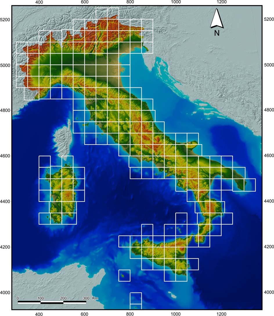
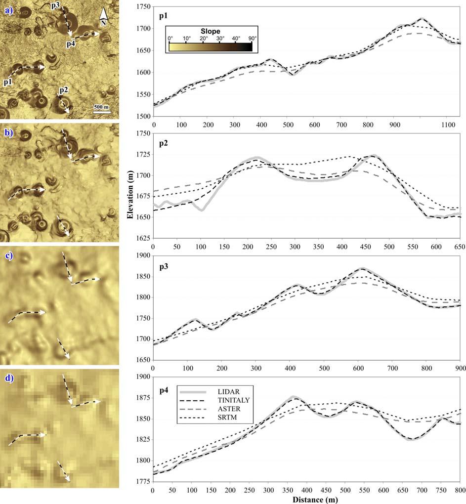
3 <h1>2. The TINITALY/01 DEM TINITALY/01 is a DEM in triangular irregular network format (TIN) created for the whole Italian territory in the UTM 32 WGS 84 coordinate system (Tarquini et al., 2007). The DEM was obtained from heterogeneous vector datasets, mostly consisting in elevation contour lines and elevation points from several sources. The input vector database was carefully cleaned up to obtain a seamless TIN derived by using the DEST algorithm (Favalli and Pareschi, 2004). The whole TINITALY/01 DEM was converted in grid format (10-m cell size) according to a tiled structure composed of 193, 50-km side square elements (Fig. 1). The grid database consists of more than 3 billions of cells and occupies 12 Gb of disk memory. <Fig. 1 here> <H1>3. The TINITALY/01 DEM vs global-coverage DEMs In recent years, an increasing number of elevation datasets covering entire countries are available to the public. Examples are the 10- or 30-m resolution National Elevation Dataset for the United States (NED; the 10-m resolution DEM for Japan (Geographical Survey Institute of Japan; the 5- or 10-m resolution DEM for the UK ( or else the 50-m resolution BD ALTI DEM for France. Here we briefly compare the TINITALY/01 DEM with the two spaceborne-based DEMs with an almost global coverage recently released via the web: the 90-m resolution SRTM and the 30-m resolution ASTER elevation datasets. These two DEMs cover also the whole Italian territory. At the beginning of this century a quasi-global elevation dataset from the SRTM was released (Rabus et al., 2003). It consists of a 90-m cell size DEM which has been shown to be appropriate for morphometric analyses over large areas or to focus on the broad morphology of features. The ASTER DEM with a 30-m cell size has been released more recently (Hayakawa et al., 2008). The ASTER has a higher resolution with respect to the SRTM dataset. Nevertheless, this fact does not necessarily imply a higher DEM quality, because, as an example, the ASTER DEM is affected by the limits of the ASTER sensor, which is locally disturbed by clouds (Hubbard et al., 2007). Tarquini et al. (2007) carried out a comprehensive assessment of the accuracy of the TINITALY/01 DEM, finding a root mean square error in elevation (RMSEz) between 0.8 and 6.0 m. Rabus et al. (2003), for the SRTM elevation dataset, found an absolute vertical accuracy of ± 16 m at 90% confidence, while Hirano et al. (2007) found an RMSEz for the ASTER DEM within the 2
4 design specification of 7 50 m. For both ASTER and SRTM DEMs, the error increases as the topography become rougher. As an example, for the ASTER DEM, Kaab (2002) found an RMSEz of 60 m in rough high mountains and 18 m in moderately mountainous terrains. <Fig. 2 here> An in-depth comparison is beyond the scope of the present work; nevertheless, we selected an example to highlight the characteristics of the TINITALY/01 DEM with respect to the two globalcoverage SRTM and ASTER DEMs. We selected Mount Etna (Sicily, Italy), where a very high resolution, LIDAR-derived topography was available for comparison (Favalli et al., 2009). In this area, the TINITALY/01 DEM showed an RMSEz of 1.98 m (Neri et al., 2008), while we calculated an RMSEz of 7.78 and 9.36 m for the SRTM and ASTER DEMs, respectively. Fig. 2 shows the elevation profiles obtained from the LIDAR-derived DEM, the 10-m cell size TINITALY/01 grid, and ASTER and SRTM DEMs. The two spaceborne-based DEMs are too coarse to precisely reveal fundamental features such as cone craters and cone outlines, while the TINITALY/01 DEM provides the necessary detail. <H1>4. Anaglyph-mode navigation of the DEM and related webgis The human brain is equipped to produce a 3D perception of an observed scene by coupling two images acquired by the eyes from a slightly different point of view. This is the basic principle of the stereo vision, widely applied for the examination of couples of aerial stereoscopic photographs. The observation in stereo mode conveys a deeper understanding of landscape morphologies, and can fruitfully support the detection of subtle features. Add-on modules enabling 3D vision in anaglyph mode have been recently made available for both freeware and commercial programs (e.g., Google Earth and ESRI ArcGIS), suggesting the validity of this method. Here we use a custom software (Tarquini and Favalli, 2011) which produces full-resolution anaglyph images from arbitrarily large DEMs, to obtain a seamless anaglyph layer of the entire TINITALY/01 database at 10-m resolution. The ESRI ArcGIS server is used to set up a webgis ( where the described 10-m resolution anaglyph layer is freely accessible for navigation (Fig. 3). The viewpoints for anaglyph creation are set symmetrically to a nadiral axis pointing toward the center of Italy, at an almost infinite distance, obtaining a very low distortion. The anaglyph layer is georeferenced in the UTM WGS84 zone 32 projection system. To view the anaglyphs, users must wear 3
5 anaglyph glasses with a green (or blue) left lens and a red right lens, but we set up also a layer of shaded relief images with an elevation color ramp. <Fig. 3 here> <H1>5. Concluding remarks The 10-m resolution TINITALY/01 DEM (Tarquini et al., 2007) is compared with the two, coarser resolution, global-coverage, spaceborne-based SRTM and ASTER DEMs and with a high resolution LIDAR-derived DEM. Afterward, we presented a webgis which allows the exploration of a 10-m resolution anaglyph layer showing the landforms of the whole Italian territory in 3D. The webgis ( is open to the public, and can be used to carry out a preliminary analysis of landforms. The TINITALY/01 DEM is now available for scientific purposes on the basis of a research agreement (write to tinitaly@pi.ingv.it). References<style> Favalli, M., Fornaciai, A., Pareschi, M.T., LIDAR strip adjustment: Application to volcanic areas. Geomorphology 111, Favalli, M., Pareschi, M.T., Digital elevation model construction from structured topographic data: The DEST algorithm. Journal of Geophysical Research 109, F Hayakawa, Y.S., Oguchi, T., Lin, Z., Comparison of new and existing global digital elevation models: ASTER G-DEM and SRTM-3. Geophysical Research Letters 35, L Hirano, A., Welch, R., Lang, W., Mapping from ASTER stereo image data: DEM validation and accuracy assessment. ISPRS Journal of Photogrammetry and Remote Sensing 57, Hubbard, B.E., Sheridan, M.F., Carrasco-Núñez, G., Díaz-Castellón, R., Rodríguez, S.R., Comparative lahar hazard mapping at Volcan Citlaltépetl, Mexico using SRTM, ASTER and DTED-1 digital topographic data. Journal of Volcanology and Geothermal Research 160, Kaab, A, Combination of SRTM3 and repeat ASTER data for deriving alpine glacier flow velocities in the Bhutan Himalaya. Remote Sensing of Environment 94,
6 Neri, M., Mazzarini, F., Tarquini, S., Bisson, M., Isola, I., Behncke, B., Pareschi M.T., The changing face of Mount Etna s summit area documented with Lidar technology. Geophys. Res. Lett. 35, L Rabus, B., Eineder,M., Roth, A., Bamler, R., The shuttle radar topographymission A new class of digital elevation models acquired by spaceborne radar. Journal of Photogrammetry and Remote Sensing 57, Tarquini S., Favalli, M., Capturing full resolution perspective and stereo views of large DEMs. Rapporto Tecnico INGV 181. Tarquini, S., Isola, I., Favalli, M., Mazzarini, F., Bisson, M., Pareschi, M.T., Boschi, E., TINITALY/01: A new Triangular Irregular Network of Italy. Annals of Geophysics 50,
7 Figure captions: Fig. 1. Shaded relief image with color table of the TINITALY/01 DEM with the tiles composing the elevation dataset. For the European countries we used the SRTM DEM, while the bathymetry is from the GEBCO dataset ( Ticks mark UTM WGS 84-km coordinates. Fig. 2. Comparison of the elevation profiles obtained by using a LIDAR-derived topography, the TINITALY/01 grid, the ASTER, and the SRTM elevation datasets. Fig. 3. Example of anaglyph image of the Majella Mountain (Abruzzo region, Italy), obtained from the TINITALY/01 DEM. Ticks mark UTM 32 WGS 84-km coordinates. 6
8 Fig 1: 7
9 Fig 2: 8
10 Fig 3: 9
The changing face of Mount Etna s summit area documented with Lidar technology
 GEOPHYSICAL RESEARCH LETTERS, VOL. 35, L09305, doi:10.1029/2008gl033740, 2008 The changing face of Mount Etna s summit area documented with Lidar technology M. Neri, 1 F. Mazzarini, 2 S. Tarquini, 2 M.
Digital Elevation Models (DEM) / DTM
 / DTM") Digital Elevation Models (DEM) / DTM Uses in remote sensing: queries and analysis, 3D visualisation, classification input Fogo Island, Cape Verde Republic ASTER DEM / image Banks Peninsula, Christchurch,
Digital Elevation Models (DEM) / DTM Uses in remote sensing: queries and analysis, 3D visualisation, classification input Fogo Island, Cape Verde Republic ASTER DEM / image Banks Peninsula, Christchurch,
Digital Elevation Models (DEM) / DTM
 / DTM") Digital Elevation Models (DEM) / DTM Uses in remote sensing: queries and analysis, 3D visualisation, layers in classification Fogo Island, Cape Verde Republic ASTER DEM / image Banks Peninsula, Christchurch,
Digital Elevation Models (DEM) / DTM Uses in remote sensing: queries and analysis, 3D visualisation, layers in classification Fogo Island, Cape Verde Republic ASTER DEM / image Banks Peninsula, Christchurch,
Digital Elevation Models (DEM)
") Digital Elevation Models (DEM) Digital representation of the terrain surface enable 2.5 / 3D views Rule #1: they are models, not reality Rule #2: they always include some errors (subject to scale and data
Digital Elevation Models (DEM) Digital representation of the terrain surface enable 2.5 / 3D views Rule #1: they are models, not reality Rule #2: they always include some errors (subject to scale and data
AN EVALUATION ON THE DATA QUALITY OF SRTM DEM AT THE ALPINE AND PLATEAU AREA, NORTH-WESTERN OF CHINA
 AN EVALUATION ON THE DATA QUALITY OF SRTM DEM AT THE ALPINE AND PLATEAU AREA, NORTH-WESTERN OF CHINA Y. Liu School of Earth and Environmental Sciences, Lanzhou University, Lanzhou, 730000 -liuy@lzu.edu.cn
Keywords: ASTER, SRTM, Digital Elevation Model, GPS-Levelling data, Validation.
 www.sgem.org ACCURACY ASSESSMENT OF ASTER AND SRTM DIGITAL ELEVATION MODELS: A CASE STUDY IN TURKEY H. Tugba Arli IL 1 Dr. R. Alpay ABBAK 2 1 Ministry of Health - Turkey 2 Selcuk University - Turkey ABSTRACT
ACCURACY ASSESSMENT OF ASTER GLOBAL DEM OVER TURKEY
 ACCURACY ASSESSMENT OF ASTER GLOBAL DEM OVER TURKEY E. Sertel a a ITU, Civil Engineering Faculty, Geomatic Engineering Department, 34469 Maslak Istanbul, Turkey sertele@itu.edu.tr Commission IV, WG IV/6
GIS and Remote Sensing
 Spring School Land use and the vulnerability of socio-ecosystems to climate change: remote sensing and modelling techniques GIS and Remote Sensing Katerina Tzavella Project Researcher PhD candidate Technology
How to Construct Urban Three Dimensional GIS Model based on ArcView 3D Analysis
 How to Construct Urban Three Dimensional GIS Model based on ArcView 3D Analysis Ko Ko Lwin Division of Spatial Information Science Graduate School of Life and Environmental Sciences University of Tsukuba
Accuracy Assessment of SRTM Data Case Study: New Cairo, Hurghada and Toshka in Egypt
 Australian Journal of Basic and Applied Sciences, 4(12): 6269-6275, 2010 ISSN 1991-8178 Accuracy Assessment of SRTM Data Case Study: New Cairo, Hurghada and Toshka in Egypt 1 Assoc. Prof. Dr. A.K. Abdel-Gawad,
A Study On The Usabılıty Of Dıgıtal Elevatıon Models Obtaıned From Open Sources In The Productıon Of Contours: Comparıson Of Alos And Srtm Dem Data
 A Study On The Usabılıty Of Dıgıtal Elevatıon Models Obtaıned From Open Sources In The Productıon Of Contours: Comparıson Of Alos And Srtm Dem Data S.Cabuk a, A.C. Kiracı, M.Kaya, M.Erdogan, O.Eker, A.Okul
EMERGENCY PLANNING IN NORTHERN ALGERIA BASED ON REMOTE SENSING DATA IN RESPECT TO TSUNAMI HAZARD PREPAREDNESS
 EMERGENCY PLANNING IN NORTHERN ALGERIA BASED ON REMOTE SENSING DATA IN RESPECT TO TSUNAMI HAZARD PREPAREDNESS Barbara Theilen-Willige Technical University of Berlin, Institute of Applied Geosciences Department
AN EVALUATION OF SRTM, ASTER, AND CONTOUR BASED DEMS IN THE CARIBBEAN REGION
 Peter G. Chirico Geographer USGS, Earth Surface Processes Team 12201 Sunrise Valley Drive National Center, MS926A Reston VA, 20192 pchirico@usgs.gov AN EVALUATION OF SRTM, ASTER, AND CONTOUR BASED DEMS
This is a repository copy of Aggregation of growing crystals in suspension: III. Accounting for adhesion and repulsion.
 This is a repository copy of Aggregation of growing crystals in suspension: III. Accounting for adhesion and repulsion. White Rose Research Online URL for this paper: http://eprints.whiterose.ac.uk/88281/
ENGRG Introduction to GIS
 ENGRG 59910 Introduction to GIS Michael Piasecki March 17, 2014 Lecture 08: Terrain Analysis Outline: Terrain Analysis Earth Surface Representation Contour TIN Mass Points Digital Elevation Models Slope
ENGRG Introduction to GIS
 ENGRG 59910 Introduction to GIS Michael Piasecki November 17, 2017 Lecture 11: Terrain Analysis Outline: Terrain Analysis Earth Surface Representation Contour TIN Mass Points Digital Elevation Models Slope
SPOT DEM Product Description
 SPOT DEM Product Description Version 1.1 - May 1 st, 2004 This edition supersedes previous versions Acronyms DIMAP DTED DXF HRS JPEG, JPG DEM SRTM SVG Tiff - GeoTiff XML Digital Image MAP encapsulation
Application of differential SAR interferometry for studying eruptive event of 22 July 1998 at Mt. Etna. Abstract
 Application of differential SAR interferometry for studying eruptive event of 22 July 1998 at Mt. Etna Coltelli M. 1, Puglisi G. 1, Guglielmino F. 1, Palano M. 2 1 Istituto Nazionale di Geofisica e Vulcanologia,
GeoSUR SRTM 30-m / TPS
 GeoSUR SRTM 30-m / TPS Wm Matthew Cushing (USGS) 16 May 2013 U.S. Department of the Interior U.S. Geological Survey SRTM Mission Shuttle Radar Topography Mission (SRTM) Space Shuttle Endeavour during the
PROANA A USEFUL SOFTWARE FOR TERRAIN ANALYSIS AND GEOENVIRONMENTAL APPLICATIONS STUDY CASE ON THE GEODYNAMIC EVOLUTION OF ARGOLIS PENINSULA, GREECE.
 PROANA A USEFUL SOFTWARE FOR TERRAIN ANALYSIS AND GEOENVIRONMENTAL APPLICATIONS STUDY CASE ON THE GEODYNAMIC EVOLUTION OF ARGOLIS PENINSULA, GREECE. Spyridoula Vassilopoulou * Institute of Cartography
A relation between lava discharge rate, thermal insulation, and flow area set using lidar data
 GEOPHYSICAL RESEARCH LETTERS, VOL. 37,, doi:10.1029/2010gl044683, 2010 A relation between lava discharge rate, thermal insulation, and flow area set using lidar data Andrew Harris, 1 Massimiliano Favalli,
Bathymetry Data and Models: Best Practices
 Bathymetry Data and Models: Best Practices Barry Eakins & Lisa Taylor The NOAA National Geophysical Data Center Over 600 data types - from the core of the Earth to the surface of the Sun NGDC Bathymetry
Automatic Change Detection from Remote Sensing Stereo Image for Large Surface Coal Mining Area
 doi: 10.14355/fiee.2016.05.003 Automatic Change Detection from Remote Sensing Stereo Image for Large Surface Coal Mining Area Feifei Zhao 1, Nisha Bao 2, Baoying Ye 3, Sizhuo Wang 4, Xiaocui Liu 5, Jianyan
Positional accuracy of the drainage networks extracted from ASTER and SRTM for the Gorongosa National Park region - Comparative analysis
 Positional accuracy of the drainage networks extracted from ASTER and SRTM for the Gorongosa National Park region - Comparative analysis Tiago CARMO 1, Cidália C. FONTE 1,2 1 Departamento de Matemática,
General Overview and Facts about the Irobland
 Using Geoinformation Science to Reveal the Impact of the Eritrea-Ethiopia Boundary Commission s Decision on Irobland and People By Alema Tesfaye, Washington DC, USA Part I General Overview and Facts about
APPLICATION OF GIS AND REMOTE SENSING IN 3D MODELLING AND DETERMINATION OF MORPHOMETRIC FEATURES OF THE AGRI VOLCANO, AGRI, TURKEY
 APPLICATION OF GIS AND REMOTE SENSING IN 3D MODELLING AND DETERMINATION OF MORPHOMETRIC FEATURES OF THE AGRI VOLCANO, AGRI, TURKEY İrfan AKAR ABSTRACT Improving research methods and techniques present
Global Survey of Organized Landforms: Recognizing Linear Sand Dunes
 Global Survey of Organized Landforms: Recognizing Linear Sand Dunes P. L. Guth 1 1 Department of Oceanography, US Naval Academy 572C Holloway Rd, Annapolis MD 21402 USA Telephone: 00-1-410-293-6560 Fax:
The 3D Elevation Program: Overview. Jason Stoker USGS National Geospatial Program ESRI 2015 UC
 + The 3D Elevation Program: Overview Jason Stoker USGS National Geospatial Program ESRI 2015 UC + 2 A little history USGS has a long, proud tradition of mapmaking (2009) + 3 The changing times Mapping
Change detection at the recently erupted Te Maari crater, Tongariro, from stereo aerial photographs
 Change detection at the recently erupted Te Maari crater, Tongariro, from stereo aerial photographs Strong, D.T., Jones, K.E., Ashraf, S. and Lee, J. Outline Geographic context Setting and eruption Science
COMPARISON OF SRTM AND 25K TOPOGRAPHIC MAPS IN TURKEY
 COMPARISON OF SRTM AND 25K TOPOGRAPHIC MAPS IN TURKEY Oztug Bildirici 1, Aydin Ustun, Necla Ulugtekin 2, H. Zahit Selvi 1, Alpay Abbak 1, Ilkay Bugdayci 1, A. Ozgur Dogru 2 1 Selcuk University, Faculty
Detecting the development of active lava flow fields with a very-long-range terrestrial laser scanner and thermal imagery
 GEOPHYSICAL RESEARCH LETTERS, VOL. 36, L22305, doi:10.1029/2009gl040701, 2009 Detecting the development of active lava flow fields with a very-long-range terrestrial laser scanner and thermal imagery M.
QUANTITATIVE ASSESSMENT OF DIGITAL TOPOGRAPHIC DATA FROM DIFFERENT SOURCES
 QUANTITATIVE ASSESSMENT OF DIGITAL TOPOGRAPHIC DATA FROM DIFFERENT SOURCES N. Yastıklı a, F. Esirtgen b, U. G. Sefercik c a YTU, Department of Geomatic Engineering, Davutpasa Campus, 31, Istanbul, Turkey
Use of ArcGIS Applications for Analysis and Representation of the Terrains: The Case Study of Alakır River Sub-basin
 Use of ArcGIS Applications for Analysis and Representation of the Terrains: The Case Study of Alakır River Sub-basin Ahmet BENLİAY, Tahsin YILMAZ and H. Ekin OKTAY 1 Introduction 3D visualizations have
Volume loss from Bering Glacier (Alaska), : comment on Muskett and others (2009)
, : comment on Muskett and others (2009)") Volume loss from Bering Glacier (Alaska), 1972 2003: comment on Muskett and others (2009) Berthier E. 1,2 1 CNRS; LEGOS; 14 Av. Ed. Belin, F-31400 Toulouse, France 2 Université de Toulouse; UPS (OMP-PCA);
Volume loss from Bering Glacier (Alaska), 1972 2003: comment on Muskett and others (2009) Berthier E. 1,2 1 CNRS; LEGOS; 14 Av. Ed. Belin, F-31400 Toulouse, France 2 Université de Toulouse; UPS (OMP-PCA);
Implementation of CLIMAP and GIS for Mapping the Climatic Dataset of Northern Iraq
 Implementation of CLIMAP and GIS for Mapping the Climatic Dataset of Northern Iraq Sabah Hussein Ali University of Mosul/Remote sensing Center KEYWORDS: CLIMAP, GIS, DEM, Climatic, IRAQ ABSTRACT The main
Generation and analysis of Digital Elevation Model (DEM) using Worldview-2 stereo-pair images of Gurgaon district: A geospatial approach
 using Worldview-2 stereo-pair images of Gurgaon district: A geospatial approach") 186 Generation and analysis of Digital Elevation Model (DEM) using Worldview-2 stereo-pair images of Gurgaon district: A geospatial approach Arsad Khan 1, Sultan Singh 2 and Kaptan Singh 2 1 Department
186 Generation and analysis of Digital Elevation Model (DEM) using Worldview-2 stereo-pair images of Gurgaon district: A geospatial approach Arsad Khan 1, Sultan Singh 2 and Kaptan Singh 2 1 Department
INTERNATIONAL JOURNAL OF GEOMATICS AND GEOSCIENCES Volume 6, No 1, 2015
 INTERNATIONAL JOURNAL OF GEOMATICS AND GEOSCIENCES Volume 6, No 1, 2015 Copyright 2010 All rights reserved Integrated Publishing services Research article ISSN 0976 4380 Vertical accuracy assessment of
Utilization and Provision of Geographical Name Information on the Basic Map of Japan*
 UNITED NATIONS WORKING PAPER GROUP OF EXPERTS NO. 1/9 ON GEOGRAPHICAL NAMES Twenty-eight session 28 April 2 May 2014 Item 9 of the Provisional Agenda Activities relating to the Working Group on Toponymic
Welcome to NR502 GIS Applications in Natural Resources. You can take this course for 1 or 2 credits. There is also an option for 3 credits.
 Welcome to NR502 GIS Applications in Natural Resources. You can take this course for 1 or 2 credits. There is also an option for 3 credits. The 1st credit consists of a series of readings, demonstration,
Popular Mechanics, 1954
 Introduction to GIS Popular Mechanics, 1954 1986 $2,599 1 MB of RAM 2017, $750, 128 GB memory, 2 GB of RAM Computing power has increased exponentially over the past 30 years, Allowing the existence of
Positional Accuracy of the Google Earth Imagery In The Gaza Strip
 Positional Accuracy of the Google Earth Imagery In The Gaza Strip Maher A. El-Hallaq Associate Professor of Surveying Civil Engineering Department The Islamic University of Gaza, Palestine mhallaq@iugaza.edu.ps
INSTITUTE OF AERONAUTICAL ENGINEERING (Autonomous) Dundigal, Hyderabad
 Dundigal, Hyderabad") INSTITUTE OF AERONAUTICAL ENGINEERING (Autonomous) Dundigal, Hyderabad -00 0 CIVIL ENGINEERING TUTORIAL QUESTION BANK Course Name : Remote Sensing and GIS Course Code : A00 Class : IV B. Tech I Semester
INSTITUTE OF AERONAUTICAL ENGINEERING (Autonomous) Dundigal, Hyderabad -00 0 CIVIL ENGINEERING TUTORIAL QUESTION BANK Course Name : Remote Sensing and GIS Course Code : A00 Class : IV B. Tech I Semester
MRD 207 METADATA DETAIL PAGE
 MRD 207 METADATA DETAIL PAGE The following represents the Basic description of an information holding. To obtain more information about this holding, see the section named Contacts. GENERAL INFORMATION
UPDATING AND REFINEMENT OF NATIONAL 1: DEM. National Geomatics Center of China, Beijing
 UPDATING AND REFINEMENT OF NATIONAL 1:500000 DEM Jian-jun LIU a, Dong-hua WANG a, Yao-ling SHANG a, Wen-hao ZHAO a Xi KUAI b a National Geomatics Center of China, Beijing 100830 b School of Resources and
NR402 GIS Applications in Natural Resources
 NR402 GIS Applications in Natural Resources Lesson 1 Introduction to GIS Eva Strand, University of Idaho Map of the Pacific Northwest from http://www.or.blm.gov/gis/ Welcome to NR402 GIS Applications in
DATA APPLIANCE FOR ARCGIS
 DATA APPLIANCE FOR ARCGIS Data Appliance for ArcGIS Provides Access to Multi-Scale Basemaps Down to Medium Scale Levels Worldwide And Large Scale for Most of the World The Data Appliance includes Several
ISO Swift Current LiDAR Project 2009 Data Product Specifications. Revision: A
 ISO 19131 Swift Current LiDAR Project 2009 Data Product Specifications Revision: A Data product specifications: Swift Current LiDAR Project 2009 - Table of Contents- 1. Overview... 4 1.1. Informal description...
Determining the Location of the Simav Fault
 Lindsey German May 3, 2012 Determining the Location of the Simav Fault 1. Introduction and Problem Formulation: The issue I will be focusing on involves interpreting the location of the Simav fault in
Measuring earthquake-generated surface offsets from high-resolution digital topography
 Measuring earthquake-generated surface offsets from high-resolution digital topography July 19, 2011 David E. Haddad david.e.haddad@asu.edu Active Tectonics, Quantitative Structural Geology, and Geomorphology
INTEGRATION OF HIGH RESOLUTION QUICKBIRD IMAGES TO GOOGLEEARTH
 INTEGRATION OF HIGH RESOLUTION QUICKBIRD IMAGES TO GOOGLEEARTH M. Alkan a, *, U.G. Sefercik a, M. Oruç a a ZKU, Engineering Faculty, 67100 Zonguldak, Turkey - (mehmetalkan44@yahoo.com) Interactive Sessions,
Digital Elevation Model (DEM) Generation from Stereo Images
 Generation from Stereo Images") Pertanika J. Sci. & Technol. 19 (S): 77-82 (2011) ISSN: 0128-7680 Universiti Putra Malaysia Press Digital Elevation Model (DEM) Generation from Stereo Images C. E. Joanna Tan *, M. Z. Mat Jafri, H. S.
Pertanika J. Sci. & Technol. 19 (S): 77-82 (2011) ISSN: 0128-7680 Universiti Putra Malaysia Press Digital Elevation Model (DEM) Generation from Stereo Images C. E. Joanna Tan *, M. Z. Mat Jafri, H. S.
Evolution of an active lava flow field using a multitemporal LIDAR acquisition
 JOURNAL OF GEOPHYSICAL RESEARCH, VOL. 115,, doi:10.1029/2010jb007463, 2010 Evolution of an active lava flow field using a multitemporal LIDAR acquisition M. Favalli, 1 A. Fornaciai, 1 F. Mazzarini, 1 A.
SOLUTIONS ADVANCED GIS. TekMindz are developing innovative solutions that integrate geographic information with niche business applications.
 ADVANCED GIS SOLUTIONS TekMindz are developing innovative solutions that integrate geographic information with niche business applications. TEK INDZ TM GIS Services Overview At the leading edge of geospatial
Working with Digital Elevation Models and Spot Heights in ArcMap
 Working with Digital Elevation Models and Spot Heights in ArcMap 10.3.1 1 TABLE OF CONTENTS INTRODUCTION... 3 WORKING WITH SPOT HEIGHTS FROM NRVIS, CITY OF KITCHENER, AND CITY OF TORONTO...4 WORKING WITH
Xiaojun Yang a a Department of Geography, Florida State University, Tallahassee, FL32306, USA Available online: 22 Feb 2007
 This article was downloaded by: [USGS Libraries Program] On: 29 May 2012, At: 15:41 Publisher: Taylor & Francis Informa Ltd Registered in England and Wales Registered Number: 1072954 Registered office:
ABSOLUTE AND RELATIVE GRAVITY MEASUREMENTS AT ETNA VOLCANO (ITALY)
") ABSOLUTE AND RELATIVE GRAVITY MEASUREMENTS AT ETNA VOLCANO (ITALY) F. Greco 1, G. Currenti 1, G. D Agostino 2, C. Del Negro 1, A. Di Stefano 1, A. Germak 2, R. Napoli 1, C. Origlia 2, A. Pistorio 1, 3,
ABSOLUTE AND RELATIVE GRAVITY MEASUREMENTS AT ETNA VOLCANO (ITALY) F. Greco 1, G. Currenti 1, G. D Agostino 2, C. Del Negro 1, A. Di Stefano 1, A. Germak 2, R. Napoli 1, C. Origlia 2, A. Pistorio 1, 3,
ALOS PRISM DEM V2 product guide
 ESA DUE Permafrost ALOS PRISM DEM V2 product guide Vienna University of Technology Institute of Photogrammetry and Remote Sensing Gamma Remote Sensing Department of Geography and Environmental Management
Surface roughness of pyroclastic deposits at Mt. Etna by 3D laser scanning
 ANNALS OF GEOPHYSICS, VOL. 51, N. 5/6, October/December 2008 Surface roughness of pyroclastic deposits at Mt. Etna by 3D laser scanning Francesco Mazzarini ( 1 ), Massimiliano Favalli ( 1 ), Ilaria Isola
Multi-sourced 3D Geospatial Terrain Modelling: Issues and Challenges
 10th Conference on Cartography and Geoinformation, Zagreb, Croatia Multi-sourced 3D Geospatial Terrain Modelling: Issues and Challenges Prof. Dr. Yerach Doytsher Mapping and Geo-Information Engineering,
Geospatial capabilities, spatial data and services provided by Military Geographic Service
 Geospatial capabilities, spatial data and services provided by Military Geographic Service LtC Mariyan Markov PhD CONTENTS 1. INTRODUCTION - Workflow - Data sources remote sensing, direct field observation.
Geomorphologic Mapping by Airborne Laser Scanning in Southern Victoria Land
 Geomorphologic Mapping by Airborne Laser Scanning in Southern Victoria Land Bea Csatho, Terry Wilson, Tony Schenk, Garry McKenzie, Byrd Polar Research Center, The Ohio State University, Columbus, OH William
Riskscape module Documentation: Inundation Modelling in Bay of Plenty. X. Wang C. Mueller
 Riskscape module Documentation: Inundation Modelling in Bay of Plenty X. Wang C. Mueller CONTENTS 1.0 GENERAL INFORMATION... 2 1.1 SITE OF STUDY... 5 1.2 SOURCE SCENARIOS... 5 1.3 NUMERICAL MODEL... 5
GIS Workshop Data Collection Techniques
 GIS Workshop Data Collection Techniques NOFNEC Conference 2016 Presented by: Matawa First Nations Management Jennifer Duncan and Charlene Wagenaar, Geomatics Technicians, Four Rivers Department QA #: FRG
Working with Elevation Services. Cody Benkelman
 Working with Elevation Services Cody Benkelman Outline ArcGIS Online World Elevation & 3D Elevation Cache for Pro What is included? - Data and Tools How can I use it? - Modes of use - Client Applications
USING LIDAR MEASUREMENTS FOR IMPROVING OR UP-DATING A DEM
 JAES_1(14)_3_2011 VAIS M. et. all, pp.123-128 SECTION Geodesic Engineering USING LIDAR MEASUREMENTS FOR IMPROVING OR UP-DATING A DEM VAIS Manuel*, IOSIF Gheorghe, Bucharest University, *e-mail: manuel.vais@sipg.ro
GLL THE STUDY OF METHODS FOR CORRECTING GLOBAL DIGITAL TERRAIN MODELS USING REMOTE SENSING DATA. I. Kolb, M. Lucyshyn, M. Panek
 GLL http://dx.doi.org/10.15576/gll/2013.3.59 Geomatics, Landmanagement and Landscape No. 3 2013, 59 66 THE STUDY OF METHODS FOR CORRECTING GLOBAL DIGITAL TERRAIN MODELS USING REMOTE SENSING DATA Ihor Kolb,
Application of high-resolution (10 m) DEM on Flood Disaster in 3D-GIS
 DEM on Flood Disaster in 3D-GIS") Risk Analysis V: Simulation and Hazard Mitigation 263 Application of high-resolution (10 m) DEM on Flood Disaster in 3D-GIS M. Mori Department of Information and Computer Science, Kinki University, Japan
Risk Analysis V: Simulation and Hazard Mitigation 263 Application of high-resolution (10 m) DEM on Flood Disaster in 3D-GIS M. Mori Department of Information and Computer Science, Kinki University, Japan
GIS APPLICATIONS IN SOIL SURVEY UPDATES
 GIS APPLICATIONS IN SOIL SURVEY UPDATES ABSTRACT Recent computer hardware and GIS software developments provide new methods that can be used to update existing digital soil surveys. Multi-perspective visualization
Volcanic Deformation and Evolution.
 Volcanic Deformation and Evolution of Mt. Saint SitHelens http://pubs.usgs.gov/sim/3008/ B. A. Digital perspective view derived from USGS Digital Elevation Model (DEM) of Mount St. Helens as seen from
Imagery and the Location-enabled Platform in State and Local Government
 Imagery and the Location-enabled Platform in State and Local Government Fred Limp, Director, CAST Jim Farley, Vice President, Leica Geosystems Oracle Spatial Users Group Denver, March 10, 2005 TM TM Discussion
ISO INTERNATIONAL STANDARD. Geographic information Metadata Part 2: Extensions for imagery and gridded data
 INTERNATIONAL STANDARD ISO 19115-2 First edition 2009-02-15 Geographic information Metadata Part 2: Extensions for imagery and gridded data Information géographique Métadonnées Partie 2: Extensions pour
Pan-Arctic Digital Elevation Map (Pan-Arctic DEM)
") Memorandum to CAFF Board 07/28/2017 BACKGROUND: Pan-Arctic Digital Elevation Map (Pan-Arctic DEM) ArcticDEM is a National Geospatial-Intelligence Agency (NGA)-National Science Foundation (NSF) publicprivate
Memorandum to CAFF Board 07/28/2017 BACKGROUND: Pan-Arctic Digital Elevation Map (Pan-Arctic DEM) ArcticDEM is a National Geospatial-Intelligence Agency (NGA)-National Science Foundation (NSF) publicprivate
What s New in Topographic Information - USGS National Map
 + What s New in Topographic Information - USGS National Map SARGIS Workshop November 14, 2016 Rob Dollison, 703-648-5724 rdollison@usgs.gov + USGS 2 National Geospatial Program The National Geospatial
GEOMATICS. Shaping our world. A company of
 GEOMATICS Shaping our world A company of OUR EXPERTISE Geomatics Geomatics plays a mayor role in hydropower, land and water resources, urban development, transport & mobility, renewable energy, and infrastructure
SPANISH GOOD (AND NO SO GOOD) PRACTICES IMPLEMENTING INSPIRE
 PRACTICES IMPLEMENTING INSPIRE") SPANISH GOOD (AND NO SO GOOD) PRACTICES IMPLEMENTING INSPIRE HELLO! I am Emilio López I am here because I am the Director of the National Centre for Geographic Information You can find me at elromero@fomento.es
SPANISH GOOD (AND NO SO GOOD) PRACTICES IMPLEMENTING INSPIRE HELLO! I am Emilio López I am here because I am the Director of the National Centre for Geographic Information You can find me at elromero@fomento.es
Submitted to. Prepared by
 Prepared by Tim Webster, PhD Candace MacDonald Applied Geomatics Research Group NSCC, Middleton Tel. 902 825 5475 email: tim.webster@nscc.ca Submitted to Harold MacNeil Engineering Manager Halifax Water
Innovative image geo-referencing tool for decision support in wildfire fighting
 Modelling, Monitoring and Management of Forest Fires II 173 Innovative image geo-referencing tool for decision support in wildfire fighting A. Losso, L. Corgnati & G. Perona Turin Polytechnic, Italy Abstract
MRD-160 METADATA DETAIL PAGE
 MRD-160 METADATA DETAIL PAGE The following represents the Basic description of an information holding. To obtain more information about this holding, see the section named Contacts. GENERAL INFORMATION
Intelligent Marine and Coastal Mapping Data
 O Intelligent Marine and Coastal Mapping Data When you need mapping data that is fit for purpose, in the right format, accurate and up to date Marine Themes Vector Marine Themes DEM Raster Charts XL Electronic
Southwestern Ontario Orthophotography Project (SWOOP) 2015 Digital Elevation Model
 2015 Digital Elevation Model") Southwestern Ontario Orthophotography Project (SWOOP) 2015 Digital Elevation Model User Guide Provincial Mapping Unit Mapping and Information Resources Branch Corporate Management and Information Division
Southwestern Ontario Orthophotography Project (SWOOP) 2015 Digital Elevation Model User Guide Provincial Mapping Unit Mapping and Information Resources Branch Corporate Management and Information Division
These modules are covered with a brief information and practical in ArcGIS Software and open source software also like QGIS, ILWIS.
 Online GIS Training and training modules covered are: 1. ArcGIS, Analysis, Fundamentals and Implementation 2. ArcGIS Web Data Sharing 3. ArcGIS for Desktop 4. ArcGIS for Server These modules are covered
Validation of the ASTER Global Digital Elevation Model (GDEM) Version 2 over the Conterminous United States
 Version 2 over the Conterminous United States") Validation of the ASTER Global Digital Elevation Model (GDEM) Version 2 over the Conterminous United States U.S. Geological Survey Earth Resources Observation Science (EROS) Center Sioux Falls, South Dakota,
Validation of the ASTER Global Digital Elevation Model (GDEM) Version 2 over the Conterminous United States U.S. Geological Survey Earth Resources Observation Science (EROS) Center Sioux Falls, South Dakota,
38, Tripoleos Str., Athens , Greece, 23, Velvedou Str., Athens , Greece,
 A Feature Based Accuracy Evaluation of GTOPO30 Miliaresis, G. Ch 1 & Paraschou, C. V. E. 2 Remote Sensing Laboratory, National Technical University of Athens, 1 38, Tripoleos Str., Athens 104-42, Greece,
SPOT DEM Precision Product description
 SPOT DEM Precision Product description Version1.0 - April 1st, 2006 This edition supersedes previous versions Acronyms DIMAP DTED DXF HRS JPEG, JPG Mb DTM DEM SRTM SVG TIFF - GeoTIFF XML Digital Image
PROFILING OF MAJOR RIVER SYSTEMS AROUND MAYON VOLCANO USING AIRSAR IMAGES
 PROFILING OF MAJOR RIVER SYSTEMS AROUND MAYON VOLCANO USING AIRSAR IMAGES Rowena B. QUIAMBAO, Ronnie C. Torres Philippine Institute of Volcanology & Seismology C.P. Garcia Street, University of the Philippines
THE REVISION OF 1:50000 TOPOGRAPHIC MAP OF ONITSHA METROPOLIS, ANAMBRA STATE, NIGERIA USING NIGERIASAT-1 IMAGERY
 I.J.E.M.S., VOL.5 (4) 2014: 235-240 ISSN 2229-600X THE REVISION OF 1:50000 TOPOGRAPHIC MAP OF ONITSHA METROPOLIS, ANAMBRA STATE, NIGERIA USING NIGERIASAT-1 IMAGERY 1* Ejikeme, J.O. 1 Igbokwe, J.I. 1 Igbokwe,
Lecture 11. Data Standards and Quality & New Developments in GIS
 Lecture 11 Data Standards and Quality & New Developments in GIS Lecture 11: Outline I. Data Standards and Quality 1. Types of Spatial Data Standards 2. Data Accuracy II. New Developments/The Future of
Large Scale Mapping Policy for the Province of Nova Scotia
 Large Scale Mapping Policy for the Province of Nova Scotia December, 2005 Version 1.0 TABLE OF CONTENTS PAGE BACKGROUND...3 POLICY...5 Policy 1.0 Large Scale Mapping Program...5 Policy 2.0 Service Offering...5
Global Assessment of the New ASTER Global Digital Elevation Model
 Global Assessment of the New ASTER Global Digital Elevation Model James A. Slater, Barry Heady, George Kroenung, William Curtis, Jeffrey Haase, Daryl Hoegemann, Casey Shockley, and Kevin Tracy Abstract
DRAPE 2014 Digital Elevation Model
 DRAPE 2014 Digital Elevation Model User Guide Spatial Data Infrastructure Mapping and Information Resources Branch Corporate Management and Information Division Ministry of Natural Resources and Forestry
What you learned. Lecture 27: Class Summary. Maps and geodesy. How you learned it
 What you learned Geography 12: Maps and Spatial Reasoning Lecture 27: Class Summary Professor Keith Clarke Map geometry, construction and content Practical map use, reading and navigation Map representation
Title Accuracy assessment of GIS techniques for measuring volumetric loss at Mount St. Helens
 Andrew Nelson Geog 493 - Digital Terrain Analysis Portland State University 7 Dec, 2017 Title Accuracy assessment of GIS techniques for measuring volumetric loss at Mount St. Helens Abstract The 1980 eruption
Understanding the role of land cover / land use nexus in malaria transmission under changing socio-economic climate in Myanmar
 Annual Report for Year 1 June, 2017 January, 2018 NASA Land Cover Land Use Change Program Funded under grant # NNX17AI06G: Understanding the role of land cover / land use nexus in malaria transmission
A Temporal Hydrologic Database for Rapidly Changing Landscapes
 A Temporal Hydrologic Database for Rapidly Changing Landscapes Using Mt. St. Helens in Washington as a Pilot Site Adam Mosbrucker Geog 575 BACKGROUND: Client / User U.S. Geological Survey Cascades Volcano
Uncertainty modeling of glacier surface mapping from GPS: An example from Pedersenbreen, Arctic
 Uncertainty modeling of glacier surface mapping from GPS: An example from Pedersenbreen, Arctic Xi Zhao, Songtao Ai 1 Chinese Antarctic Center of Surveying and Mapping, Wuhan University, Wuhan 430079,
VISUALIZATION URBAN SPATIAL GROWTH OF DESERT CITIES FROM SATELLITE IMAGERY: A PRELIMINARY STUDY
 CO-439 VISUALIZATION URBAN SPATIAL GROWTH OF DESERT CITIES FROM SATELLITE IMAGERY: A PRELIMINARY STUDY YANG X. Florida State University, TALLAHASSEE, FLORIDA, UNITED STATES ABSTRACT Desert cities, particularly
Dynamic Creation of Bump Images and Profile Generation from DEM Gaurav Dongre 1 Ms. Pratibha M. Umale 2
 International Journal for Research in Technological Studies Vol. 1, Issue 6, May 2014 ISSN (online): 2348-1439 Dynamic Creation of Bump Images and Profile Generation from DEM Gaurav Dongre 1 Ms. Pratibha
OZ SEEBASE TM. Datasets. Digital Elevation Model
 Digital Elevation Model 10 Digital Elevation Models (DEM s) often show the youngest structures, and any active geological structures. They are widely used for neotectonic analysis. The composition of eroding
USGS Community Engagement and its Role in Improving The National Map
 USGS Community Engagement and its Role in Improving The National Map ESRI User Conference, 2014 Bob Davis Carol Ostergren Drew Decker USGS Strategic Direction Provides a sharpened focus on our topographic
GeoWEPP Tutorial Appendix
 GeoWEPP Tutorial Appendix Chris S. Renschler University at Buffalo - The State University of New York Department of Geography, 116 Wilkeson Quad Buffalo, New York 14261, USA Prepared for use at the WEPP/GeoWEPP