Change detection at the recently erupted Te Maari crater, Tongariro, from stereo aerial photographs
|
|
|
- Job McLaughlin
- 5 years ago
- Views:
Transcription


1 Change detection at the recently erupted Te Maari crater, Tongariro, from stereo aerial photographs Strong, D.T., Jones, K.E., Ashraf, S. and Lee, J.
2 Outline Geographic context Setting and eruption Science and hazard questions Methods Imagery and software Block triangulation Orthorectification Digital Stereo Models Change detection Results Block triangulation Orthorectification DSM creation Change detection Comparison of DTMs Summary Geological mapping from stereo photos RS capability at GNS Science
3 Tongariro National Park Auckland New Zealand s oldest national park Three volcanoes: Tongariro Ngauruhoe Ruapheu Wellington Christchurch Dunedin

4 Tongariro National Park Topography Geology
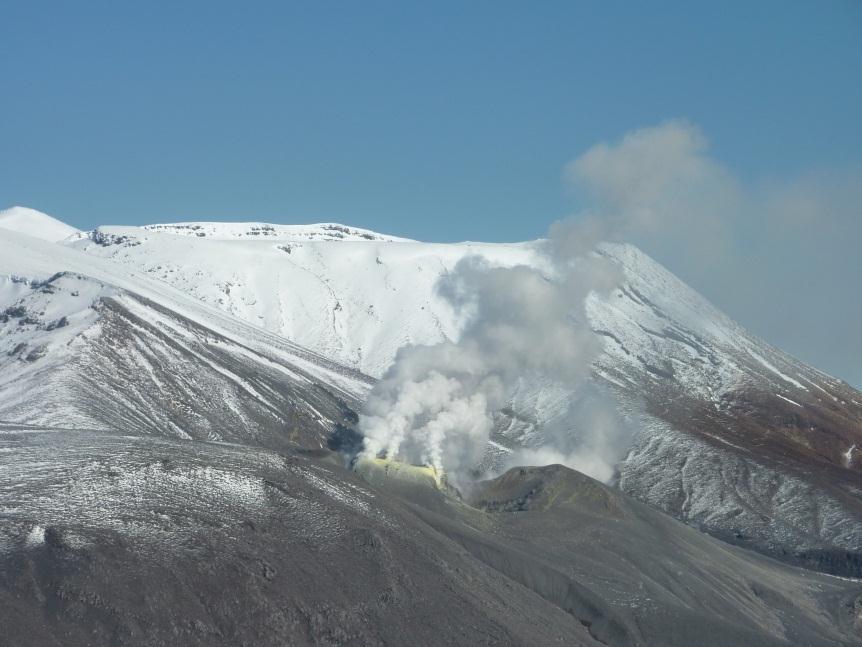
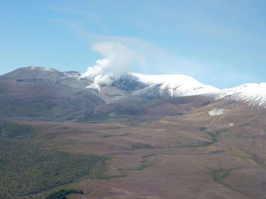
5 Te Maari crater, Mount Tongariro Eruptions at Te Maari in Aug and Nov 2012 A new fissure was produced Continuous emissions of steam and volcanic gas expected to continue for years Map showing Te Maari eruption phenomena ()
6 Te Maari crater, Mount Tongariro Significant hazard to life Tongariro Alpine Crossing, other recreation activities Further eruptions are possible Potential hazards lava & debris flows, ash & debris falls from violent eruptions Map showing Te Maari eruption phenomena ()
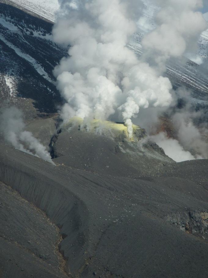
7 Background, low-level steam emission All photographs: / EQC

8 The eruption recorded in a nearby seismograph drum

9 Eruption time lapse video Geonet


10 Steam from the new fissure and Te Maari crater ~400 year old lava flow All photographs: / EQC


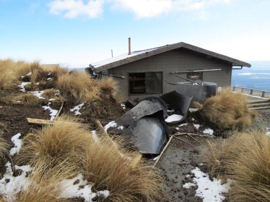
11 Damage to Ketetahi Hut, Tongariro Crossing
12 Science & hazard What questions are the geologists asking? What is the volume of the debris erupted? Where is the new fissure located? How long & wide is the new fissure? Remote sensing provides access to high hazard areas Te Maari crater area is still largely inaccessible to volcanologists


13 Can we detect geomorphic change at the crater? What features can we see with the eye? Lava flow, crater rim, fluvial channel Part of the Tongariro Crossing track 2010 aerial photograph mosaic 2012 aerial photograph mosaic
14 Can we detect changes in elevation at the crater? What features can we see with the eye? Lava flow, crater rim, fluvial channel New fissure, new debris flow Can we quantify these? Before and after aerial photographs Build digital surface models (DSMs) Extract changes in elevation Map changes in geomorphological features
 2012 (post-eruption) same solar")
 ERDAS Imagine 2013 ArcGIS 10.")
15 Images and software Digital aerial photographs from NZ Aerial Mapping 2010 (pre-eruption) 2012 (post-eruption) same solar incidence November some cloud cover, steam from vents in 2012 Leica Photogrammetry Suite (LPS) ERDAS Imagine 2013 ArcGIS 10.0

16 2010 digital aerial photo orthomosaic

17 2012 digital aerial photo orthomosaic
18 Methods 1) Block triangulation (LPS) 2) Image orthorectification (LPS) orthomosaics for 2010 and 2012 (ERDAS 2013) 3) Digital Surface Models (DSMs) (LPS) 4) Extract elevation changes between DSMs (ArcGIS)
19 Block triangulation Digital aerial photos Camera calibration reports from NZAM Block area ~ 20 km Image acquisition date 17/11/ /11/2012 Sensor UltraCamXp UltraCamX Image size (megapixel/image) Ground pixel size (m) Av. flying altitude (m)
 0.3402 0.2944 Control point RMSE X,Y,Z (m) 2.15, 2.98, 2.63 1.72, 2.56, 2.")
20 Block triangulation Automatic tie point generator Collected GCPs on-screen horizontal reference = existing orthomosaic of aerial photos vertical reference = 8 m DEM (Geographx) No. of images 4 4 No. of tie points No. of ground control points Triangulation RMSE (pixels) Control point RMSE X,Y,Z (m) 2.15, 2.98, , 2.56, 2.21
21 Generating DSMs eate (enhanced Automatic Terrain Extraction) AOI to mask the crater lake Seed source = mass points from block file default seed source (globaldem) up to 20 m error Our parameters: cell size 0.5 m correlation window 5, search window 25 moderate smoothing low contrast setting (best for mountainous terrain)

22 Results: orthomosaics & DSMs 2010 orthomosaic & DSM


23 Results: orthomosaics & DSMs 2012 orthomosaic & DSM
 Deposition")
24 Results: change detection red = erosion/subsidence; green = deposition; yellow = no change in surface elevation > 4 m of vertical change (erosion or deposition) Deposition Erosion
25 Change in elevation along four profiles
26 Change detection: Profile A A B B Deposition in and along channel up to 26 m A C Deposition Erosion C D D
27 Change detection: Profile B A B B Deposition in and along channel up to 23 m A C Deposition Erosion C D D
28 Change detection: Profile C A B B Accumulation across debris flow path Erosion of surface Deposition Erosion A C C D D
29 Change detection: Profile D A B B Up to 46 m of erosion A C Deposition Erosion C D D
30 Old vs new DTMs for geological mapping Let s look at the crater rim

31 Old vs new DTMs for geological mapping New 0.5 m 2010 DTM Old 8 m DTM
32 Old vs new DTMs for geological mapping Exposed lava sheets around crater rim New 0.5 m 2010 DTM Old 8 m DTM
33 Summary of Te Maari crater work Comparison of DSMs shows clearly defined changes in surface elevation Maximum debris accumulation ~26 m thick Maximum erosion ~46 m 2012 eruptions drove geomorphic change a new fissure opened up erosion of existing surface & deposition of debris Methods and materials used here are suited to high resolution geomorphic mapping
34 Big picture: DTM of Tongariro National Park Geological Map of Tongariro National Park (Townsend, Leonard and others, in prep) 3D (stereo) feature collection will be used to map some components of the geology & geomorphology >300 aerial photographs 2010 and 2012 ~50 km 2 area Highly diverse, mountainous terrain maximum elevation approximately 2,800 m ASL slopes reach >70 degrees, crater walls are nearvertical

35 1:50,000 map Digitised at various scales as high as 1:2,500


 Julie Lee")
36 Applying our remote sensing capability Salman Ashraf Hazard response earthquakes, landslides, volcanic eruptions, flooding, coastal erosion, tsunami Geological mapping DTM and orthomosaic generation 3D (stereo) feature collection 3D geology modelling (Leapfrog Geothermal) Resource mapping Groundwater InSAR (Ian Hamling) Julie Lee Katie Jones Delia Strong Ian Hamling
Land-use planning and volcanic hazards: Opportunities for New Zealand
 Land-use planning and volcanic hazards: Opportunities for New Zealand Julia Becker, Wendy Saunders, Graham Leonard, David Johnston, Lower Hutt Clare Robertson, Massey University, Palmerston North Presentation
Digital Elevation Models (DEM) / DTM
 / DTM") Digital Elevation Models (DEM) / DTM Uses in remote sensing: queries and analysis, 3D visualisation, classification input Fogo Island, Cape Verde Republic ASTER DEM / image Banks Peninsula, Christchurch,
Digital Elevation Models (DEM) / DTM Uses in remote sensing: queries and analysis, 3D visualisation, classification input Fogo Island, Cape Verde Republic ASTER DEM / image Banks Peninsula, Christchurch,
Digital Elevation Models (DEM) / DTM
 / DTM") Digital Elevation Models (DEM) / DTM Uses in remote sensing: queries and analysis, 3D visualisation, layers in classification Fogo Island, Cape Verde Republic ASTER DEM / image Banks Peninsula, Christchurch,
Digital Elevation Models (DEM) / DTM Uses in remote sensing: queries and analysis, 3D visualisation, layers in classification Fogo Island, Cape Verde Republic ASTER DEM / image Banks Peninsula, Christchurch,
GEOLOGY 285: INTRO. PETROLOGY
 Dr. Helen Lang Dept. of Geology & Geography West Virginia University FALL 2005 GEOLOGY 285: INTRO. PETROLOGY Mount St. Helens 1980 Eruption Small earthquakes Small steam and ash eruptions in March and
Digital Elevation Models (DEM)
") Digital Elevation Models (DEM) Digital representation of the terrain surface enable 2.5 / 3D views Rule #1: they are models, not reality Rule #2: they always include some errors (subject to scale and data
Digital Elevation Models (DEM) Digital representation of the terrain surface enable 2.5 / 3D views Rule #1: they are models, not reality Rule #2: they always include some errors (subject to scale and data
Generation and analysis of Digital Elevation Model (DEM) using Worldview-2 stereo-pair images of Gurgaon district: A geospatial approach
 using Worldview-2 stereo-pair images of Gurgaon district: A geospatial approach") 186 Generation and analysis of Digital Elevation Model (DEM) using Worldview-2 stereo-pair images of Gurgaon district: A geospatial approach Arsad Khan 1, Sultan Singh 2 and Kaptan Singh 2 1 Department
186 Generation and analysis of Digital Elevation Model (DEM) using Worldview-2 stereo-pair images of Gurgaon district: A geospatial approach Arsad Khan 1, Sultan Singh 2 and Kaptan Singh 2 1 Department
USING GIS CARTOGRAPHIC MODELING TO ANALYSIS SPATIAL DISTRIBUTION OF LANDSLIDE SENSITIVE AREAS IN YANGMINGSHAN NATIONAL PARK, TAIWAN
 CO-145 USING GIS CARTOGRAPHIC MODELING TO ANALYSIS SPATIAL DISTRIBUTION OF LANDSLIDE SENSITIVE AREAS IN YANGMINGSHAN NATIONAL PARK, TAIWAN DING Y.C. Chinese Culture University., TAIPEI, TAIWAN, PROVINCE
Structure from Motion Photogrammetry for 3D Reconstruction of Crater Glacier on Mount St. Helens, Washington, USA
 Julian Cross GEOG 593 Department of Geography Portland State University 12/5/16 Structure from Motion Photogrammetry for 3D Reconstruction of Crater Glacier on Mount St. Helens, Washington, USA Abstract:
EAS 116 Earthquakes and Volcanoes
 EAS 116 Earthquakes and Volcanoes J. Haase Forecasting Volcanic Eruptions Assessment of Volcanic Hazard Is that volcano active? Mount Lassen: 12000 BP and 1915 Santorini, IT: 180,000 BP, 70,000 BP, 21000
Mapping the Surface of Mars Prelab. 1. Explain in your own words what you think a "geologic history" for a planet or moon is?
 Prelab 1. Explain in your own words what you think a "geologic history" for a planet or moon is? 2. Describe some of the major features seen on the Martian surface by various spacecraft missions over the
Topographical Change Monitoring for Susceptible Landslide Area Determination by Using Multi-Date Digital Terrain Models and LiDAR
 Topographical Change Monitoring for Susceptible Landslide Area Determination by Using Multi-Date Digital Terrain Models and Chanist PRASERTBURANAKUL 1, Parkorn SUWANICH 2, Kanchana NAKHAPAKORN 3, and Sukit
Use of UAV mounted /Structure-from-Motion (SfM) data capture for engineering geological landslide mapping
 data capture for engineering geological landslide mapping") Bevan, D.J., Brook, M.S., Tunnicliffe, J., Richards, N.P. & Prebble, W.M. (2017) Use of Proc. 20 th NZGS Geotechnical Symposium. Eds. GJ Alexander & CY Chin, Napier Use of UAV mounted /Structure-from-Motion
Bevan, D.J., Brook, M.S., Tunnicliffe, J., Richards, N.P. & Prebble, W.M. (2017) Use of Proc. 20 th NZGS Geotechnical Symposium. Eds. GJ Alexander & CY Chin, Napier Use of UAV mounted /Structure-from-Motion
A Temporal Hydrologic Database for Rapidly Changing Landscapes
 A Temporal Hydrologic Database for Rapidly Changing Landscapes Using Mt. St. Helens in Washington as a Pilot Site Adam Mosbrucker Geog 575 BACKGROUND: Client / User U.S. Geological Survey Cascades Volcano
Application of high-resolution (10 m) DEM on Flood Disaster in 3D-GIS
 DEM on Flood Disaster in 3D-GIS") Risk Analysis V: Simulation and Hazard Mitigation 263 Application of high-resolution (10 m) DEM on Flood Disaster in 3D-GIS M. Mori Department of Information and Computer Science, Kinki University, Japan
Risk Analysis V: Simulation and Hazard Mitigation 263 Application of high-resolution (10 m) DEM on Flood Disaster in 3D-GIS M. Mori Department of Information and Computer Science, Kinki University, Japan
Highs and Lows Floods and Flows
 Highs and Lows Floods and Flows Planetary Mapping Facilitator Guide Becky Nelson Education Specialist The Lunar and Planetary Institute Highs and Lows, Floods and Flows Planetary Mapping Overview In this
Lessons learnt from 2014 Mt Ontake and 2000 Mt Usu eruptions: findings from a post-eruption ballistic impact assessment trip to Japan
 Lessons learnt from 2014 Mt Ontake and 2000 Mt Usu eruptions: findings from a post-eruption ballistic impact assessment trip to Japan Rebecca Fitzgerald, Ben Kennedy, Thomas Wilson, Graham Leonard, Kae
Student task. Which factors affect the impact of a hazardous event?
 Student task Both volcanic eruptions and earthquakes often have a catastrophic impact and devastating effects. What similarities can you see in these three photographs? Lava slowly flowing over Chain of
ENVIRONMENTAL GEOSCIENCE UNIFORM SYLLABUS
 ENVIRONMENTAL GEOSCIENCE UNIFORM SYLLABUS The Association of Professional Engineers and Geoscientists of the Province of British Columbia Note: 1. This Syllabus May Be Subject To Change 2. These Courses
Positional accuracy of the drainage networks extracted from ASTER and SRTM for the Gorongosa National Park region - Comparative analysis
 Positional accuracy of the drainage networks extracted from ASTER and SRTM for the Gorongosa National Park region - Comparative analysis Tiago CARMO 1, Cidália C. FONTE 1,2 1 Departamento de Matemática,
Applications of GIS in assessing Coastal Change Rachel Hehre November 30, 2004 NRS 509 OVERVIEW
 Applications of GIS in assessing Coastal Change Rachel Hehre November 30, 2004 NRS 509 OVERVIEW ITRODUCTION Due to the dynamic nature of coastal systems, representing coastal change with precision and
The Seismic Hazardscape of New Zealand
 The Seismic Hazardscape of New Zealand Mark Stirling Professor of Earthquake Science Introduction Plate tectonic setting of New Zealand Seismic hazards for University of Otago campuses Kaikoura earthquake
LEMBAGA PENERBANGAN DAN ANTARIKSA NASIONAL INDONESIAN NATIONAL INSTITUTE OF AERONAUTICS AND SPACE (LAPAN)
") LEMBAGA PENERBANGAN DAN ANTARIKSA NASIONAL INDONESIAN NATIONAL INSTITUTE OF AERONAUTICS AND SPACE (LAPAN) The Utilization of Remotely Sensed Data to Analyze The Estimated Volume of Pyroclastic Deposits
LEMBAGA PENERBANGAN DAN ANTARIKSA NASIONAL INDONESIAN NATIONAL INSTITUTE OF AERONAUTICS AND SPACE (LAPAN) The Utilization of Remotely Sensed Data to Analyze The Estimated Volume of Pyroclastic Deposits
Automatic Change Detection from Remote Sensing Stereo Image for Large Surface Coal Mining Area
 doi: 10.14355/fiee.2016.05.003 Automatic Change Detection from Remote Sensing Stereo Image for Large Surface Coal Mining Area Feifei Zhao 1, Nisha Bao 2, Baoying Ye 3, Sizhuo Wang 4, Xiaocui Liu 5, Jianyan
Volcanic Eruptions (pp )
") Name Date Class Volcanic Eruptions (pp. 221 228) This section explains how volcanoes erupt and describes types of volcanic eruptions as well as other types of volcanic activity. The section also describes
Name Date Class Volcanic Eruptions (pp. 221 228) This section explains how volcanoes erupt and describes types of volcanic eruptions as well as other types of volcanic activity. The section also describes
Volcanoes. Environmental Geology, Mr. Paul Lowrey Stacey Singleton, Cassandra Combs, Dwight Stephenson, Matt Smithyman
 Volcanoes Environmental Geology, Mr. Paul Lowrey Stacey Singleton, Cassandra Combs, Dwight Stephenson, Matt Smithyman EMPACTS Project, Spring 2017 Northwest Arkansas Community College, Bentonville, AR
Erupted and killed approximately 15,000 people 200 years ago
 1 2 3 4 5 6 7 8 Introduction to Environmental Geology, 5e Chapter 8 Volcanic Activity Volcanoes: summary in haiku form A volcano forms. Magma comes to the surface - explodes, if felsic. Case History: Mt.
RS / GIS for Disaster Management. Some Important Definitions. Classifications of Natural Disasters. Disasters W/Some Human Influence
 RS / GIS for Disaster Management A Basic Introduction to Natural Disasters Using Remote Sensing & GIS ~~~~~~~~~~ Rev. Ronald J. Wasowski, C.S.C. Associate Professor of Environmental Science University
ENGRG Introduction to GIS
 ENGRG 59910 Introduction to GIS Michael Piasecki March 17, 2014 Lecture 08: Terrain Analysis Outline: Terrain Analysis Earth Surface Representation Contour TIN Mass Points Digital Elevation Models Slope
Canadian Consulting Engineering Awards 2017 Southern Alberta Rock Slope Stabilization & Other Work Amec Foster Wheeler
 Southern Alberta Rock Slope Stabilization & Other Work Amec Foster Wheeler To: Mr. Doug Picklyk Editor, Canadian Consulting Engineer magazine Date April 20, 2017 From: Chelsea Johnson, P.Eng. Amec Foster
Volcanoes Shake and Bake Indoor Activity
 Mount St Helens National Volcanic Monument Teacher s Corner 2011 Gifford Pinchot National Forest USDA Forest Service Volcanoes Shake and Bake Indoor Activity Time Commitment: Trail: Location: 45 minutes
AN EVALUATION OF SRTM, ASTER, AND CONTOUR BASED DEMS IN THE CARIBBEAN REGION
 Peter G. Chirico Geographer USGS, Earth Surface Processes Team 12201 Sunrise Valley Drive National Center, MS926A Reston VA, 20192 pchirico@usgs.gov AN EVALUATION OF SRTM, ASTER, AND CONTOUR BASED DEMS
Watershed Delineation in GIS Environment Rasheed Saleem Abed Lecturer, Remote Sensing Centre, University of Mosul, Iraq
 Watershed Delineation in GIS Environment Rasheed Saleem Abed Lecturer, Remote Sensing Centre, University of Mosul, Iraq Abstract: The management and protection of watershed areas is a major issue for human
Minnisblað Figures Figure 1. Figure 2
 Memo Rockslide in Askja, July 21 2014 - Preliminary results of observations Jón Kristinn Helgason, Sveinn Brynjólfsson, Tómas Jóhannesson, Kristín S. Vogfjörð and Harpa Grímsdóttir; Icelandic Meteorological
LECTURE #11: Volcanoes: Monitoring & Mitigation
 GEOL 0820 Ramsey Natural Disasters Spring, 2018 LECTURE #11: Volcanoes: Monitoring & Mitigation Date: 15 February 2018 I. What is volcanic monitoring? the continuous collection of one or more data sources
ENGRG Introduction to GIS
 ENGRG 59910 Introduction to GIS Michael Piasecki November 17, 2017 Lecture 11: Terrain Analysis Outline: Terrain Analysis Earth Surface Representation Contour TIN Mass Points Digital Elevation Models Slope
Continuous Caldera Changes in Miyakejima Volcano after Hiroyuki HASEGAWA, Hiroshi P. SATO and Junko IWAHASHI
 Continuous Caldera Changes in Miyakejima Volcano after 2001 60 Hiroyuki HASEGAWA, Hiroshi P. SATO and Junko IWAHASHI Abstract This study investigated the evolvement of the caldera at Miyakejima volcano
Application of differential SAR interferometry for studying eruptive event of 22 July 1998 at Mt. Etna. Abstract
 Application of differential SAR interferometry for studying eruptive event of 22 July 1998 at Mt. Etna Coltelli M. 1, Puglisi G. 1, Guglielmino F. 1, Palano M. 2 1 Istituto Nazionale di Geofisica e Vulcanologia,
GEOMATICS. Shaping our world. A company of
 GEOMATICS Shaping our world A company of OUR EXPERTISE Geomatics Geomatics plays a mayor role in hydropower, land and water resources, urban development, transport & mobility, renewable energy, and infrastructure
Debris flow: categories, characteristics, hazard assessment, mitigation measures. Hariklia D. SKILODIMOU, George D. BATHRELLOS
 Debris flow: categories, characteristics, hazard assessment, mitigation measures Hariklia D. SKILODIMOU, George D. BATHRELLOS Natural hazards: physical phenomena, active in geological time capable of producing
Geo 327G Semester Project. Landslide Suitability Assessment of Olympic National Park, WA. Fall Shane Lewis
 Geo 327G Semester Project Landslide Suitability Assessment of Olympic National Park, WA Fall 2011 Shane Lewis 1 I. Problem Landslides cause millions of dollars of damage nationally every year, and are
Moon 101. Bellaire High School Team: Rachel Fisher, Clint Wu, Omkar Joshi
 Moon 101 Bellaire High School Team: Rachel Fisher, Clint Wu, Omkar Joshi Part I Formation of the Moon Planetary Formation In the solar nebula, dust particles coalesced to form smaller planetesimals and
Digital Elevation Model (DEM) Generation from Stereo Images
 Generation from Stereo Images") Pertanika J. Sci. & Technol. 19 (S): 77-82 (2011) ISSN: 0128-7680 Universiti Putra Malaysia Press Digital Elevation Model (DEM) Generation from Stereo Images C. E. Joanna Tan *, M. Z. Mat Jafri, H. S.
Pertanika J. Sci. & Technol. 19 (S): 77-82 (2011) ISSN: 0128-7680 Universiti Putra Malaysia Press Digital Elevation Model (DEM) Generation from Stereo Images C. E. Joanna Tan *, M. Z. Mat Jafri, H. S.
Photogeology In Terrain Evaluation (Part 1) Prof. Javed N Malik. Department of Earth Sciences Indian Institute of Technology, Kanpur
 Prof. Javed N Malik. Department of Earth Sciences Indian Institute of Technology, Kanpur") Photogeology In Terrain Evaluation (Part 1) Prof. Javed N Malik. Department of Earth Sciences Indian Institute of Technology, Kanpur Lecture 01 Introduction to Remote Sensing Photogeology Hello everybody.
Photogeology In Terrain Evaluation (Part 1) Prof. Javed N Malik. Department of Earth Sciences Indian Institute of Technology, Kanpur Lecture 01 Introduction to Remote Sensing Photogeology Hello everybody.
Figure 8-21 Distribution of Lava Flow for the Model
 Figure 8-21 Distribution of Lava Flow for the Model 2) Pyroclastic Flow The energy cone model was used for the simulation. a. The angle of inclination of Energy Line, φ, from the summit was 5.3 degrees
Examining the Terrestrial Planets (Chapter 20)
") GEOLOGY 306 Laboratory Instructor: TERRY J. BOROUGHS NAME: Examining the Terrestrial Planets (Chapter 20) For this assignment you will require: a calculator, colored pencils, a metric ruler, and your geology
GEOLOGY 306 Laboratory Instructor: TERRY J. BOROUGHS NAME: Examining the Terrestrial Planets (Chapter 20) For this assignment you will require: a calculator, colored pencils, a metric ruler, and your geology
Assessment of the Incidence of Landslides Using Numerical Information
 PAPER Assessment of the Incidence of Landslides Using Numerical Information Atsushi HASEGAWA Takehiro OHTA, Dr. Sci. Assistant Senior Researcher, Senior Researcher, Laboratory Head, Geology Laboratory,
Introduction. Background
 Introduction In introducing our research on mars we have asked the question: Is there a correlation between the width of an impact crater and the depth of that crater? This will lead to answering the question:
Lessons learnt using GIS to map geological hazards following the Christchurch earthquake
 Gerrard, L.C, Herbert J.A & Revell T.A.J (2013) Proc. 19 th NZGS Geotechnical Symposium. Ed. CY Chin, Queenstown Lessons learnt using GIS to map geological hazards following the Christchurch earthquake
Donald K. Stauble and Bill Birkemeier Coastal and Hydraulics Laboratory US Army Corps of Engineers
 Donald K. Stauble and Bill Birkemeier Coastal and Hydraulics Laboratory US Army Corps of Engineers Define the Problem Navigation Shore Protection Environmental Political So what is the problem? Management
INFRARED AND SATELLITE IMAGES, AERIAL PHOTOGRAPHY
 Presented at Short Course VI on Exploration for Geothermal Resources, organized by UNU-GTP, GDC and KenGen, at Lake Bogoria and Lake Naivasha, Kenya, Oct. 27 Nov. 18, 2011. GEOTHERMAL TRAINING PROGRAMME
Magma is a complex mixture of liquid, solid and gas
 Magma is a complex mixture of liquid, solid and gas Liquid molten silicate Solid early-formed minerals Gas Generally 0.1% to 5% of the magma by weight, but can be as much as 15% >90% of the gas in magma
Social Studies 9 UNIT 2 GEOGRAPHIC INFLUENCES ON IDENTITY: PLACE AND PEOPLE
 Social Studies 9 UNIT 2 GEOGRAPHIC INFLUENCES ON IDENTITY: PLACE AND PEOPLE The Structure of the Earth To understand the forces that create Canada's physical landscape we must understand the structure
The financial and communal impact of a catastrophe instantiated by. volcanoes endlessly impact on lives and damage expensive infrastructure every
 Chapter 1 Introduction The financial and communal impact of a catastrophe instantiated by geophysical activity is significant. Landslides, subsidence, earthquakes and volcanoes endlessly impact on lives
Tatsuo Sekiguchi* and Hiroshi Sato*
 by Tatsuo Sekiguchi* and Hiroshi Sato* ABSTRACT Landslides induced by heavy rainfall and earthquakes may result in disaster by destroying homes and buildings. High-fluidity landslides caused by liquefied
Debris Avalanches. Debris avalanche deposits on a volcano in Chile. All of the area in the foreground is buried by a thick debris avalanche.
 Debris Avalanches Volcanoes are not very stable structures. From time to time, they collapse producing large rock and ash avalanches that travel at high speeds down valleys. Collapse maybe caused by an
FOUNDATIONS OF GEOLOGY CHAPTER 2
 FOUNDATIONS OF GEOLOGY CHAPTER 2 2.3A- VOLCANOES Volcanoes all share common characteristics. Vent- a central channel through which gases, ash and rock are ejected. Magma- molten rock which lies several
Deterministic Ballistic Hazard Assessment of Mount Ruapehu, New Zealand
 1 2 3 4 5 6 7 8 9 10 11 12 13 14 15 16 17 18 19 20 21 22 23 24 25 26 27 28 29 30 31 32 33 34 35 36 37 38 39 40 41 42 43 44 Frontiers Abroad, New Zealand 10 June 2016 Deterministic Ballistic Hazard Assessment
DAMAGE DETECTION OF THE 2008 SICHUAN, CHINA EARTHQUAKE FROM ALOS OPTICAL IMAGES
 DAMAGE DETECTION OF THE 2008 SICHUAN, CHINA EARTHQUAKE FROM ALOS OPTICAL IMAGES Wen Liu, Fumio Yamazaki Department of Urban Environment Systems, Graduate School of Engineering, Chiba University, 1-33,
Relative Dating of Volcanic Flows on a Back-Arc Stratovolcano
 Daniel Walsh Research Paper Relative Dating of Volcanic Flows on a Back-Arc Stratovolcano Abstract: The accurate dating of lava flows is important if we are to understand the eruptive nature of volcanoes.
ANALYSIS OF GLACIER CHANGE IN THE SIERRA NEVADA PORTLAND STATE UNIVERSITY DEPARTMENT OF GEOLOGY BRADLEY BUSELLI
 ANALYSIS OF GLACIER CHANGE IN THE SIERRA NEVADA PORTLAND STATE UNIVERSITY DEPARTMENT OF GEOLOGY BRADLEY BUSELLI Study area: Sierra Nevada (Glaciers, 2015) Closer look (Glaciers, 2015) Primary goal: Research
Year 8 Practice Questions for Summative Assessment. NAME:...
 Year 8 Practice Questions for Summative Assessment. NAME:... Earthquakes and Volcanoes 1. (a) The diagram below shows a simple cross section of the Earth. Complete the labels. (b) Name an earthquake you
Geography Class XI Fundamentals of Physical Geography Section A Total Periods : 140 Total Marks : 70. Periods Topic Subject Matter Geographical Skills
 Geography Class XI Fundamentals of Physical Geography Section A Total Periods : 140 Total Marks : 70 Sr. No. 01 Periods Topic Subject Matter Geographical Skills Nature and Scope Definition, nature, i)
SCIENCE TEST1 (VWILLIAMSSCIENCETEST1)
") Name: Date: 1. In which of the following areas would soil erosion MOST LIKELY occur if they received the same amount of rainfall? A. a forest B. flat agricultural lands C. agricultural lands on steep slopes
Name: Date: 1. In which of the following areas would soil erosion MOST LIKELY occur if they received the same amount of rainfall? A. a forest B. flat agricultural lands C. agricultural lands on steep slopes
Preparing Landslide Inventory Maps using Virtual Globes
 Introduction: A landslide is the movement of a mass of rock, debris, or earth down a slope, under the influence of gravity. Landslides can be caused by different phenomena, including intense or prolonged
BANGLADESH SURVEY OF BANGLADESH PREMISES
 BANGLADESH SURVEY OF BANGLADESH PREMISES Survey of Bangladesh (SOB) is the National Mapping organization of Bangladesh SOB is carrying out all Geodetic activities of Bangladesh SOB is responsible for taking
Nick Varley Universidad de Colima, Mexico
 Nick Varley Universidad de Colima, Mexico nick@ucol.mx Remote sensing often is the first signal of a new eruption for remote volcanoes Fumarole direct temperature measurements Spring water temperatures
GEOLOGY MEDIA SUITE Chapter 12
 UNDERSTANDING EARTH, SIXTH EDITION GROTZINGER JORDAN GEOLOGY MEDIA SUITE Chapter 12 Volcanoes 2010 W.H. Freeman and Company Plate tectonics explains the global pattern of volcanism. Key Figure 12.20 (page
3/7/17. #16 - Case Studies of Volcanoes II. Announcements Monday 2/27
 Announcements Monday 2/27 Exam #1: Monday Feb. 27 th, 7:15-8:15 (see web site) Last Names A - N Loomis 141 Last Names O - Z Loomis 151 Bring your student ID An old exam is posted in Compass If you are
ON THE CORRELATION OF SEDIMENTATION AND LANDSLIDES IN WU RIVER CATCHMENT INFLUENCED BY THE 1999 CHI-CHI EARTHQUAKE
 ON THE CORRELATION OF SEDIMENTATION AND LANDSLIDES IN WU RIVER CATCHMENT INFLUENCED BY THE 1999 CHI-CHI EARTHQUAKE Keh-Jian Shou 1*, Li-Yuan Fei 2, Jiin-Fa Lee 2, Cheng-Yueh Wei 2, Chiu-Ching Wu 1, Chia-Yue
What is GIS? Introduction to data. Introduction to data modeling
 What is GIS? Introduction to data Introduction to data modeling 2 A GIS is similar, layering mapped information in a computer to help us view our world as a system A Geographic Information System is a
2/25/2013. Volcanoes: summary in haiku form A volcano forms. Magma comes to the surface - explodes, if felsic.
 Introduction to Environmental Geology, 5e Edward A. Keller Chapter 8 Volcanic Activity Volcanoes: summary in haiku form A volcano forms. Magma comes to the surface - explodes, if felsic. Lecture Presentation
ACCURACY ASSESSMENT OF ASTER GLOBAL DEM OVER TURKEY
 ACCURACY ASSESSMENT OF ASTER GLOBAL DEM OVER TURKEY E. Sertel a a ITU, Civil Engineering Faculty, Geomatic Engineering Department, 34469 Maslak Istanbul, Turkey sertele@itu.edu.tr Commission IV, WG IV/6
Need of Proper Development in Hilly Urban Areas to Avoid
 Need of Proper Development in Hilly Urban Areas to Avoid Landslide Hazard Dr. Arvind Phukan, P.E. Cosultant/Former Professor of Civil Engineering University of Alaska, Anchorage, USA RI District Governor
GLG Ch 6: Volcanoes & Volcanic Hazards. 3. Name, describe (DSC) and draw the three types of volcanoes from smallest to largest.
 and draw the three types of volcanoes from smallest to largest.") GLG 101 - Ch 6: Volcanoes & Volcanic Hazards Name 6.1 What Is and and Is Not a Volcano? 1. Three common characteristics of a volcano include A B C 2. How did the Hopi Buttes (figure 06 01.b1) form? 3.
GLG 101 - Ch 6: Volcanoes & Volcanic Hazards Name 6.1 What Is and and Is Not a Volcano? 1. Three common characteristics of a volcano include A B C 2. How did the Hopi Buttes (figure 06 01.b1) form? 3.
An Introduction to Geographic Information System
 An Introduction to Geographic Information System PROF. Dr. Yuji MURAYAMA Khun Kyaw Aung Hein 1 July 21,2010 GIS: A Formal Definition A system for capturing, storing, checking, Integrating, manipulating,
Disaster Mitigation of Debris Flows, Slope Failures and Landslides 803
 Disaster Mitigation of Debris Flows, Slope Failures and Landslides 803 GIS Application on Drainage Network Extraction Madhusudan B. Shrestha and Toshitaka Miyazaki Department of Forestry, Faculty of Agriculture,
EMERGENCY PLANNING IN NORTHERN ALGERIA BASED ON REMOTE SENSING DATA IN RESPECT TO TSUNAMI HAZARD PREPAREDNESS
 EMERGENCY PLANNING IN NORTHERN ALGERIA BASED ON REMOTE SENSING DATA IN RESPECT TO TSUNAMI HAZARD PREPAREDNESS Barbara Theilen-Willige Technical University of Berlin, Institute of Applied Geosciences Department
Special edition paper
 Development of a System for Natural Disaster Risk Factor Evaluation by the EADaS Method Ryuji Oshima* Asako Togari* Masahiko Tomori* Natural disasters of a variety of scales occur along railway lines,
PROANA A USEFUL SOFTWARE FOR TERRAIN ANALYSIS AND GEOENVIRONMENTAL APPLICATIONS STUDY CASE ON THE GEODYNAMIC EVOLUTION OF ARGOLIS PENINSULA, GREECE.
 PROANA A USEFUL SOFTWARE FOR TERRAIN ANALYSIS AND GEOENVIRONMENTAL APPLICATIONS STUDY CASE ON THE GEODYNAMIC EVOLUTION OF ARGOLIS PENINSULA, GREECE. Spyridoula Vassilopoulou * Institute of Cartography
Volcanic Deformation and Evolution.
 Volcanic Deformation and Evolution of Mt. Saint SitHelens http://pubs.usgs.gov/sim/3008/ B. A. Digital perspective view derived from USGS Digital Elevation Model (DEM) of Mount St. Helens as seen from
Major External Processes Driven by energy from the sun and from gravity. Also create hazards and resources.
 Geologic Processes and Hazards Definition of Geology External and Internal Processes: examples of each Fundamentals of Plate Tectonics: definition, types of boundaries, general geography, hazards & resources
Objectives: Describe how volcanoes can affect people. Describe conditions that cause volcanoes. Describe the relationship between volcanoes and Earth
 Objectives: Describe how volcanoes can affect people. Describe conditions that cause volcanoes. Describe the relationship between volcanoes and Earth s moving plates. Inside of Old Smokey, All covered
Geomorphologic Mapping by Airborne Laser Scanning in Southern Victoria Land
 Geomorphologic Mapping by Airborne Laser Scanning in Southern Victoria Land Bea Csatho, Terry Wilson, Tony Schenk, Garry McKenzie, Byrd Polar Research Center, The Ohio State University, Columbus, OH William
Volcanic Benefits & Forecasting
 Volcanic Benefits & Forecasting Review: https://www.youtube.com/watch?v=ydy28qtdyjy 1. Based on what we know about volcanoes, predict where you might you expect to see volcanoes in and around New Zealand?
Why was this eruption important?
 Mount St. Helens Mount St. Helens has a long geological history (>3,000 yrs) of explosive eruptions. The 1980 Events: Initial relatively mild steam and ash (Vulcanian) eruptions. Sustained plinian eruption
Characterizing Volcanic Features in Banks Peninsula, New Zealand Hannah Walcek 1, 2 and Sam Hampton 1
 1 2 3 4 5 6 7 8 9 10 11 12 13 14 15 16 17 18 19 20 21 22 23 24 25 26 27 28 29 30 31 Characterizing Volcanic Features in Banks Peninsula, New Zealand Hannah Walcek 1, 2 and Sam Hampton 1 1 Department of
UGRC 144 Science and Technology in Our Lives/Geohazards
 UGRC 144 Science and Technology in Our Lives/Geohazards Session 6 Volcanic Hazards Lecturer: Dr. Patrick Asamoah Sakyi Department of Earth Science, UG Contact Information: pasakyi@ug.edu.gh College of
Breakout Session III Evolving landscapes and global environmental change
 Breakout Session III Evolving landscapes and global environmental change 1. Hydrology and critical zone imaging 2. Glaciology: Instrumenting glaciers and ice sheets 3. Polar networks and glacial isostatic
CHAPTER 2 NOTES -FOUNDATIONS OF GEOLOGY-
 CHAPTER 2 NOTES -FOUNDATIONS OF GEOLOGY- LESSON 2.1A: LAYERS OF THE EARTH GEOLOGY Geology- LAYERS OF THE EARTH Earth has 3 major layers based on their composition: o - the outer layer, made of solid rock.
THREE DIMENSIONAL DETECTION OF VOLCANIC DEPOSIT ON MOUNT MAYON USING SAR INTERFEROMETRY
 ABSTRACT THREE DIMENSIONAL DETECTION OF VOLCANIC DEPOSIT ON MOUNT MAYON USING SAR INTERFEROMETRY Francis X.J. Canisius, Kiyoshi Honda, Mitsuharu Tokunaga and Shunji Murai Space Technology Application and
Mission Pre-Briefing for Crew B
 BPLF Lunar Mission Simulations 2009 Briefing Topic: Mission Pre-Briefing for Crew B Regional Geologic Context Black Point Lava Flow 2009 Test Site BPLF occurs along the NE margin of a large volcanic field
( ) USGS (United States Geological Survey) Watch Green. Normal. alert level 1 Normal
 USGS (United States Geological Survey) Watch Green. Normal. alert level 1 Normal") (200610.1) USGS (United States Geological Survey) 1014 alert level 1 Normal Watch Green Normal USGS WARNING WATCH ADVISORY NORMAL SUMMARY OF VOLCANIC-ALERT LEVELS Highly hazardous eruption underway or
(200610.1) USGS (United States Geological Survey) 1014 alert level 1 Normal Watch Green Normal USGS WARNING WATCH ADVISORY NORMAL SUMMARY OF VOLCANIC-ALERT LEVELS Highly hazardous eruption underway or
Effects of Eruptions. Most active in the world Kilauea, Hawaii.
 Inside of Old Smokey, All covered with snow, Lurk tons of hot magma, Getting ready to blow, Objectives: From deep in the chamber, Describe how volcanoes can affect people. Up a vent to the top, Describe
GEOGRAPHY (029) CLASS XI ( ) Part A: Fundamentals of Physical Geography. Map and Diagram 5. Part B India-Physical Environment 35 Marks
 CLASS XI ( ) Part A: Fundamentals of Physical Geography. Map and Diagram 5. Part B India-Physical Environment 35 Marks") GEOGRAPHY (029) CLASS XI (207-8) One Theory Paper 70 Marks 3 Hours Part A Fundamentals of Physical Geography 35 Marks Unit-: Geography as a discipline Unit-3: Landforms Unit-4: Climate Unit-5: Water (Oceans)
GEOGRAPHY (029) CLASS XI (207-8) One Theory Paper 70 Marks 3 Hours Part A Fundamentals of Physical Geography 35 Marks Unit-: Geography as a discipline Unit-3: Landforms Unit-4: Climate Unit-5: Water (Oceans)
COSMORPHOLOGY - May 2009
 Name COSMORPHOLOGY - May 2009 Geologic landforms Purpose: By studying aerial photographs you will learn to identify different kinds of geologic features based on their different morphologies and learn
Augustine Volcano, Calculating Ash Fallout
 Augustine Volcano, 1986 - Calculating Fallout -What controls the fallout of particles through the atmosphere? -Can we predict when and where an erupted ash cloud will fall out on the Earth? Summit: 1260
DATA FUSION DECEMBER 2017 CONTOURS & BREAKLINES MANNED VS. DRONE LIDAR IDENTIFYING GEOHAZARDS VOLUME 7 ISSUE 8
 VOLUME 7 ISSUE 8 DECEMBER 2017 DATA FUSION 20 CONTOURS & BREAKLINES 26 MANNED VS. DRONE LIDAR 30 IDENTIFYING GEOHAZARDS Helping agencies request and receive the best and most appropriate data, while achieving
Investigating Volcanic Reconstruction using Akaroa Lava Benches
 Investigating Volcanic Reconstruction using Akaroa Lava Benches Jessie Bersson 1,2, Sam Hampton 1 1 University of Canterbury, Christchurch, New Zealand, Department of Geological Sciences 2 Whitman College,
Hazard assessment: Auckland Volcanic Field
 Hazard assessment: Auckland Volcanic Field Jan Lindsay SGGES & Institute of Earth Science and Engineering Hazard assessment The use of all available tools to determine the location, intensity, frequency
L wave Lahar Lava Magma
 Very large collapsed volcanic crater, often containing a lake eg. Lake Taupo The process which provides the force to move the tectonic plates Innermost part of the Earth, made of a liquid outer core and