Nick Varley Universidad de Colima, Mexico
|
|
|
- Oscar Parrish
- 5 years ago
- Views:
Transcription


1 Nick Varley Universidad de Colima, Mexico
2 Remote sensing often is the first signal of a new eruption for remote volcanoes Fumarole direct temperature measurements Spring water temperatures Radiometer large pixel detectors Temperature of PFs, lahars Thermal imaging

3 Recent development of IR cameras Getting cheaper Stable calibration Lightweight, portable instruments Thermal infrared µm Sensitivity - <0.1 C Fast up to 60 Hz

4 German camera Hr model 640 x x 240 model Resolution enhancement 1280 x μm 50 Hz Firewire SD cards 32,000 Euro (43,000 USD)

5


6
7 Passive activity Effusive activity Remote sensing of fumarole temps. Characteristics of dome growth mechanism of emplacement Estimation of effusion rate Explosive activity Characteristics depth of source, ash contents Air entrainment process Real-time monitoring with radiometers
8 Emissivity of rocks Absorption of atmosphere relative humidity Atmospheric models used
9 Comparison of object temperature and radiative heat flux. Dotted curve represents temperature/radiative heat flux conversion function. Agrees with Plancks-law over the range of interest ( 10 to 200 C) Transmissivity of a 5800 m path at 4000 m elevation using the Tropical Atmosphere Model. The contours are interpolated from values calculated using the MODTRAN code
10 Models of apparent fumarole temperatures a) Distance versus apparent temperature for theoretical fumaroles. The radiating areas and temperatures of the fumaroles are: 102 m2 at 50 C; 36.1 m2 at 100 C; 19.2 m2 at 150 C; 12.1 m2 at 200 C. Areas correspond to an apparent temperature of ~35 C at typical atmospheric conditions of 5 C and 64% relative humidity. 2 regimes. (i) apparent temperatures are controlled by the atmospheric transmissivity; (ii) control is dominated by the pixel size. b) Effect of atmospheric conditions on apparent temperature. Contour lines of apparent temperature show how it changes with weather conditions. Error bars represent mean variation within a 24 hour period. Stevenson & Varley 2008 JVGR
11 Data processing filter for clouds and explosions
 Much lower SO2 flux compared to 1998-9 although similar")

12 Dome growth (16 Oct. 2004) Much lower SO2 flux compared to although similar effusion rate magma arrived with lower volatile contents volume degassed during explosive events during Infrared 3 effusion centres, E fracture NEC camera μm

 Also calculated")
13 Thermal radiance used to calculate effusion rate Comparison with satellite data (AVHRR & MODIS) Also calculated using photos and GIS


14 Recent eruption started Jan Superimposed thermal and visual images of dome on 9 Feb Precursors 6 months before effusion started: Increase in B in spring waters Seismicity increase in LP events Increase in fumarole temperature Thermal image with white areas having temperatures > 200 C.
15 Decreasing tendency during ; 2008 onwards fairly constant A B C Negative anomaly prior to 5 June event Temperature increases and decreases related to explosions 3 fumarole zones monitored Relatively large pixel size and large distance for atmospheric effects but sufficiently sensitive to detect small variations
16 Increase in fumarole temps. Decrease occurred when dome made it to the surface


17 Dome evolution from thermography Hot spots N Pixel dimension = 0.45 m Hot spots within small explosion craters Evidence of circular structure in IR image 05 June 2007

18 N Growth directed in certain directions small lobes Exogenic 11 Nov Pixel temps. > 500 C Larger dome sides no longer show high temperature Hot central core N Extrusion on upper surface & sides Cooled lower slopes Talus accumulation 07 June 2008 Thermal insulation

19 Various methods used to estimate dome volume N First stage exogenic growth 11 Nov Pixel temps. > 500 C


20 Dome thermal analysis


21 5 April 2008 View from N View from E Hotspot 321 C Extrusion with rockfall or explosive vent


22 Explosion source N 20 July 09 Persistent hotspots Hot outside upper surface Fractures gas flow 25 Nov. 2009


23 26 Dec. 2010


24 W E Steepening & unloading on W dome side from rockfalls New lobe appears 500 C 22 May 2010 W lobe 25 February March 2010


25 Final effusive phase: lobe W side 26 December 2010 Dome is offset to W Rockfalls and unloading of this part of dome reestablished growth mechanism New lobe formed in 2010 Dome growth stopped Fresh material - rockfalls
26 Estimate volume from heat flux from slope Investigate heating of dome before rockfall Relationship with explosions Volume of rockfalls [ Volume [m3] Exposed Area Δ Temperature [ C] mean temperature 50 of rockfall traces 100 [C


27 Before Rockfall quantification A B After Rockfall 17:42 17:48 A = 250 m³ B = 558 m³ Comparison with seismic signal A B Quantify volumes lost

28 Video clip

29

30 Explosion monitoring VarioCAM infrared camera μm 3 fumarole zones monitored A B C Fumarole temperatures monitored -Looking for long-term trends -Short-term relationship with explosions Stevenson, J.A., and N. Varley, Fumarole monitoring with a handheld infrared camera: Volcán de Colima, Mexico, , Journal of Volcanology and Geothermal Research, 177 (4), , 2008.

31 Viewing platform on Nevado de Colima
32 Decreasing tendency during ; 2008 onwards fairly constant Negative anomaly prior to 5 June event Temperature increases and decreases related to explosions Relatively large pixel size and large distance for atmospheric effects but sufficiently sensitive to detect small variations


33 19-20 Nov Increase in T prior to explosion

34 Series1 150 Series2 Series3 100 Series :31:1 12:43:1 13:55:1 15:07:1 16:19:1 17:31:1 18:43:1 19:55:1 21:07:1 22:19:1 23:31: Large event of 27 July large heating prior to event, then cooling Large event of 23 Sept. prior heating & subsequent cooling over several days

35 Explosion 11/08/07 2nd pulse produces acoustic emission but no seismicity detected 2 sources shown in thermal images one rich in ash, the other poor


")


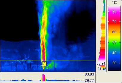
36 Calculation of heat flux Thermal expansion, air entrainment process e+8 Mean Temp Total volume 3.0e+8 80 Mean temperature C Influence of ash particle fraction 2.5e e+8 1.5e e e Time (s) Height (m) Time (s) 10 March : Column processes Volume (m ) Infrared images


37 Isla Socorro - Study of active dome


38


39 Crater Lake monitoring El Chichón, Mexico Gas emission from sides and beneath lake


40 Survey carried out of crater floor Emissions related to deep processes Controlled by geological structure 3 populations on cumulative flux plot

41 Video clip Convection within crater lake

42


43 Permanent real-time monitoring system Possible to calculate Ascent velocity Gas flux Characterize event Combined with seismic/infrasound data Depth of the explosion


44 Clear sky Clouds Real time monitoring system - comparison with seismic data


45 Radiometer data 24 hours Clear sky Explosions Clouds Relationship between seismicity and explosion column temperature is not straightforward Influenced by Variation in ash-contents difficult to quantify Cooling from air entrainment Source depth Energy release characteristics impulsive or emergent, pulses, multiple vents


46 Comparing thermal emission of explosion column with seismicity Playon 17/09/07 00:35 Flanco sur Flanco sur Playon 03/08/07 12:03 Cold gas releases occur but also hot puffs with no seismicity
Recent activity. Current episode 12 years Transition between styles 4 periods of dome growth Since 2003, Vulcanian explosions (4 25 per day)
") Recent activity Current episode 12 years Transition between styles 4 periods of dome growth Since 2003, Vulcanian explosions (4 25 per day) 02 December 09 Explosions originating from dome e.g. 10 Jan 2010
Recent activity Current episode 12 years Transition between styles 4 periods of dome growth Since 2003, Vulcanian explosions (4 25 per day) 02 December 09 Explosions originating from dome e.g. 10 Jan 2010
Degassing processes and recent activity at Volcán de Colima. Universidad de Colima, Mexico Corresponding author
 Degassing processes and recent activity at Volcán de Colima Nick Varley * & Gabriel Reyes Dávila Universidad de Colima, Mexico Corresponding author email: nick@ucol.mx Volcán de Colima is currently in
Thermal Infrared (TIR) Remote Sensing: Challenges in Hot Spot Detection
 Remote Sensing: Challenges in Hot Spot Detection") Thermal Infrared (TIR) Remote Sensing: Challenges in Hot Spot Detection ASF Seminar Series Anupma Prakash Day : Tuesday Date : March 9, 2004 Time : 2.00 pm to 2.30 pm Place : GI Auditorium Geophysical
Thermal Infrared (TIR) Remote Sensing: Challenges in Hot Spot Detection ASF Seminar Series Anupma Prakash Day : Tuesday Date : March 9, 2004 Time : 2.00 pm to 2.30 pm Place : GI Auditorium Geophysical
Images from: Boston.com
 Images from: Boston.com Ireland in the shadow of a volcano: Understanding the 2010 eruption at Eyjafjallajökull, Iceland. Chris Bean, School of Geological Sciences, UCD. World Quakes and Volcanoes 1960-2010
THERMAL REMOTE SENSING OF ACTIVE VOLCANOES
 THERMAL REMOTE SENSING OF ACTIVE VOLCANOES A User s Manual Active volcanoes emit heat through lava flows and erupting vents. Remote measurements of heat emission from such active features can provide insights
The degassing fluctuation concerning sealing process before eruptions at Sakurajima volcano, Japan.
 The degassing fluctuation concerning sealing process before eruptions at Sakurajima volcano, Japan. Ryunosuke Kazahaya, Toshiya Mori (The University of Tokyo, Tokyo, Japan. ) Masato Iguchi (Kyoto University,
EAS 116 Earthquakes and Volcanoes
 EAS 116 Earthquakes and Volcanoes J. Haase Forecasting Volcanic Eruptions Assessment of Volcanic Hazard Is that volcano active? Mount Lassen: 12000 BP and 1915 Santorini, IT: 180,000 BP, 70,000 BP, 21000
Estimates of the dynamics of volcano eruption column using real-time AVHRR data
 Estimates of the dynamics of volcano eruption column using real-time AVHRR data Ignacio Galindo Centro Universitario de Investigaciones en Ciencias del Ambiente (CUICA) UNIVERSIDAD DE COLIMA, Colima, México
Internship Report. CIIV Centro de Intercambio e Investigación en Vulcanologia
 Internship Report Host Institution: CIIV Centro de Intercambio e Investigación en Vulcanologia Colima, Mexico Dates of stay: 20/03/2017 29/08/2017 (during 6 th study term) I found the internship typing
Volcanoes drive climate variability by
 Volcanoes drive climate variability by 1. emitting ozone weeks before eruptions, 2. forming lower stratospheric aerosols that cool Earth, 3. causing sustained ozone depletion, surface warming, and lower
Volcano Surveillance Using Shortwave Infrared Thermal Data from the ERS Along Track Scanning Radiometers
 Volcano Surveillance Using Shortwave Infrared Thermal Data from the ERS Along Track Scanning Radiometers M. J. Wooster Department of Geography, King s College London, Strand, London, WC2R 2LS, UK. D.A.
LECTURE #11: Volcanoes: Monitoring & Mitigation
 GEOL 0820 Ramsey Natural Disasters Spring, 2018 LECTURE #11: Volcanoes: Monitoring & Mitigation Date: 15 February 2018 I. What is volcanic monitoring? the continuous collection of one or more data sources
NSF-MARGINS Expedition to Anatahan Volcano March 2005
 1 NSF-MARGINS Expedition to Anatahan Volcano March 2005 According to the Emergency Management Office (EMO) report distributed in February 2005, the third historical eruption of Anatahan began on January
Interpretation of Polar-orbiting Satellite Observations. Atmospheric Instrumentation
 Interpretation of Polar-orbiting Satellite Observations Outline Polar-Orbiting Observations: Review of Polar-Orbiting Satellite Systems Overview of Currently Active Satellites / Sensors Overview of Sensor
Quantification of magma ascent rate through rockfall monitoring at the growing/collapsing lava dome of Volcán de Colima, Mexico
 Quantification of magma ascent rate through rockfall monitoring at the growing/collapsing lava dome of Volcán de Colima, Mexico S. B. Mueller, N.R. Varley, U. Kueppers, Philippe Lesage, G. Reyes-Dávila,
Volcanic Plumes. JOHN WILEY & SONS Chichester New York Weinheim Brisbane Singapore Toronto
 Volcanic Plumes R. S. J. SPARKS University of Bristol, UK M. I. BURSIK State University of New York, USA S. N. CAREY University of Rhode Island, USA J. S. GILBERT Lancaster University, UK L. S. GLAZE NASA/Goddard
Remote Sensing of Precipitation
 Lecture Notes Prepared by Prof. J. Francis Spring 2003 Remote Sensing of Precipitation Primary reference: Chapter 9 of KVH I. Motivation -- why do we need to measure precipitation with remote sensing instruments?
Introduction to Volcanic Seismology
 Introduction to Volcanic Seismology Second edition Vyacheslav M. Zobin Observatorio Vulcanolo'gico, Universidad de Colima, Colima, Col., Mexico ELSEVIER AMSTERDAM BOSTON HEIDELBERG LONDON * NEW YORK OXFORD
Surface Anomalies Prior to Earthquakes
 Surface Anomalies Prior to Earthquakes Habibeh Valizadeh, Shattri B. Mansor Husaini Omar and Farid Azad Department of Civil Engineering Universiti Putra Malaysia Serdang, Selangor Malaysia shattri@eng.upm.edu.my
( ) USGS (United States Geological Survey) Watch Green. Normal. alert level 1 Normal
 USGS (United States Geological Survey) Watch Green. Normal. alert level 1 Normal") (200610.1) USGS (United States Geological Survey) 1014 alert level 1 Normal Watch Green Normal USGS WARNING WATCH ADVISORY NORMAL SUMMARY OF VOLCANIC-ALERT LEVELS Highly hazardous eruption underway or
(200610.1) USGS (United States Geological Survey) 1014 alert level 1 Normal Watch Green Normal USGS WARNING WATCH ADVISORY NORMAL SUMMARY OF VOLCANIC-ALERT LEVELS Highly hazardous eruption underway or
APPLICATIONS WITH METEOROLOGICAL SATELLITES. W. Paul Menzel. Office of Research and Applications NOAA/NESDIS University of Wisconsin Madison, WI
 APPLICATIONS WITH METEOROLOGICAL SATELLITES by W. Paul Menzel Office of Research and Applications NOAA/NESDIS University of Wisconsin Madison, WI July 2004 Unpublished Work Copyright Pending TABLE OF CONTENTS
Improvement of active volcano monitoring system in east Asia by using SGLI : preparation for realtime high spatial resolution observation
 GCOM WS 2014.1.16 Improvement of active volcano monitoring system in east Asia by using SGLI : preparation for realtime high spatial resolution observation T. Kaneko, A. Yasuda, T. Fujii and K. Kajiwara*
Influence of Clouds and Aerosols on the Earth s Radiation Budget Using Clouds and the Earth s Radiant Energy System (CERES) Measurements
 Measurements") Influence of Clouds and Aerosols on the Earth s Radiation Budget Using Clouds and the Earth s Radiant Energy System (CERES) Measurements Norman G. Loeb Hampton University/NASA Langley Research Center Bruce
Influence of Clouds and Aerosols on the Earth s Radiation Budget Using Clouds and the Earth s Radiant Energy System (CERES) Measurements Norman G. Loeb Hampton University/NASA Langley Research Center Bruce
NATURAL CLIMATIC FORCING Part II
 TOPIC #12 NATURAL CLIMATIC FORCING Part II (p 72 in Class Notes) Today we will focus on the third main driver of NATURAL CLIMATIC FORCING: 1) ATRONOMICAL FORCING 2) SOLAR FORCING 3) VOLCANIC FORCING VOLCANIC
Near real-time monitoring of the April-May 2010 Eyjafjöll s ash cloud
 Near real-time monitoring of the April-May 2010 Eyjafjöll s ash cloud Labazuy P. and the HotVolc Team Observatoire de Physique du Globe de Clermont-Ferrand, CNRS, Université Blaise Pascal 13th International
Visualizing Earth Science. Chapter Overview. Volcanoes and Eruption Types. By Z. Merali and B. F. Skinner. Chapter 9 Volcanism and Other
 Visualizing Earth Science By Z. Merali and B. F. Skinner Chapter 9 Volcanism and Other Igneous Processes Volcanoes types and effects of eruption Chapter Overview Melting and cooling of rocks Geological
Requirements for a survey system of active volcanoes based on muon radiography
 Requirements for a survey system of active volcanoes based on muon radiography Philippe LABAZUY on behalf of the TOMUVOL Collaboration http://www.tomuvol.fr/ Laboratoire Magmas et Volcans, Laboratoire
ATMOS 5140 Lecture 1 Chapter 1
 ATMOS 5140 Lecture 1 Chapter 1 Atmospheric Radiation Relevance for Weather and Climate Solar Radiation Thermal Infrared Radiation Global Heat Engine Components of the Earth s Energy Budget Relevance for
The water vapour channels of SEVIRI (Meteosat). An introduction
. An introduction") The water vapour channels of SEVIRI (Meteosat). An introduction jose.prieto@eumetsat.int Cachoeira P. July 2006 Formats 1.5 1 Objectives 2 Describe the characteristics of WV channels on board of SEVIRI
The water vapour channels of SEVIRI (Meteosat). An introduction jose.prieto@eumetsat.int Cachoeira P. July 2006 Formats 1.5 1 Objectives 2 Describe the characteristics of WV channels on board of SEVIRI
REFERENCE: The Blue Planet An Introduction to Earth System Science. Brian J. Skinner and Barbara W. Murck (2011) Third Edition. John Wiley and Sons
 Third Edition. John Wiley and Sons") REFERENCE: The Blue Planet An Introduction to Earth System Science. Brian J. Skinner and Barbara W. Murck (2011) Third Edition. John Wiley and Sons Inc. PLATE BOUNDARIES OCEAN FLOOR SEISMIC ACTIVITY WORLD'S
REFERENCE: The Blue Planet An Introduction to Earth System Science. Brian J. Skinner and Barbara W. Murck (2011) Third Edition. John Wiley and Sons Inc. PLATE BOUNDARIES OCEAN FLOOR SEISMIC ACTIVITY WORLD'S
Fracture of andesite in the brittle and brittleductile transition regimes
 Fracture of andesite in the brittle and brittleductile transition regimes R. Smith 1,*, P.R. Sammonds 1, C.R.J. Kilburn 1, H. Tuffen 2,1 1. Department of Earth Sciences, UCL, Gower Street, London, WC1E
EHaz 26 April 2007 Questions. The following questions are arranged by topic. Risk assessment & management MTU
 EHaz 26 April 2007 Questions The following questions are arranged by topic. Risk assessment & management Slide 17 (very good slide, by the way!): In the case of the Merapi and Mt. St. Helens crises, how
ESTIMATION OF ATMOSPHERIC COLUMN AND NEAR SURFACE WATER VAPOR CONTENT USING THE RADIANCE VALUES OF MODIS
 ESTIMATION OF ATMOSPHERIC COLUMN AND NEAR SURFACE WATER VAPOR CONTENT USIN THE RADIANCE VALUES OF MODIS M. Moradizadeh a,, M. Momeni b, M.R. Saradjian a a Remote Sensing Division, Centre of Excellence
GEOS 606 Physical Volcanology GEOS 606 CRN credits
 GEOS 606 Physical Volcanology GEOS 606 CRN 74060 3 credits September 1th December 17 th, 2011 Mondays, Wednesdays and Fridays MWF 10:30-11:30 Irving 208 and Elvey 101 Dr. Jonathan Dehn office: WRRB 108G,
Observations of Integrated Water Vapor and Cloud Liquid Water at SHEBA. James Liljegren
 Observations of Integrated Water Vapor and Cloud Liquid Water at SHEBA James Liljegren Ames Laboratory Ames, IA 515.294.8428 liljegren@ameslab.gov Introduction In the Arctic water vapor and clouds influence
1. minerals - A naturally occurring substance that takes a solid Crystal form and is made of only a single (one) type of compound
 type of compound") Science Name: Mr. G/Mrs. Kelly KEY Date: Study Guide - Lessons 5 and 6 Test Define the following terms: 1. minerals - A naturally occurring substance that takes a solid Crystal form and is made of only
Science Name: Mr. G/Mrs. Kelly KEY Date: Study Guide - Lessons 5 and 6 Test Define the following terms: 1. minerals - A naturally occurring substance that takes a solid Crystal form and is made of only
Estimates of the Dynamics of Volcano Eruption Column Using Real-time AVHRR Data
 Estimates of the Dynamics of Volcano Eruption Column Using Real-time AVHRR Data Ignacio Galindo Centro Universitario de Investigaciones en Ciencias del Ambiente (CUICA) UNIVERSIDAD DE COLIMA, Colima, México
Multi-parameter investigations at Fuego and Santiaguito volcanoes
 Multi-parameter investigations at Fuego and Santiaguito volcanoes John Lyons Michigan Technological University PASI Workshop - January 2011, Costa Rica PIRE 0530109 Multi-parameter approach to studying
When Mount St. Helens erupted, trapped gases caused the north side of the mountain to explode. Volcanic ash was ejected high into the atmosphere.
 When Mount St. Helens erupted, trapped gases caused the north side of the mountain to explode. Volcanic ash was ejected high into the atmosphere. A volcano is a mountain that forms when magma reaches the
INFRARED AND SATELLITE IMAGES, AERIAL PHOTOGRAPHY
 Presented at Short Course VI on Exploration for Geothermal Resources, organized by UNU-GTP, GDC and KenGen, at Lake Bogoria and Lake Naivasha, Kenya, Oct. 27 Nov. 18, 2011. GEOTHERMAL TRAINING PROGRAMME
Remote Detection and Monitoring of Volcanic Eruptions in the East African Rift
 Remote Detection and Monitoring of Volcanic Eruptions in the East African Rift Simon Carn 1, David Fee 2, Fred Prata 3 1 Department of Geological and Mining Engineering and Sciences, Michigan Technological
Detection from Space of Active Volcanism on Earth and, Potentially, on Venus and Rocky Exoplanets
 Detection from Space of Active Volcanism on Earth and, Potentially, on Venus and Rocky Exoplanets Pete Mouginis Mark Hawaii Institute Geophysics and Planetology University of Hawaii Overview Styles of
UGRC 144 Science and Technology in Our Lives/Geohazards
 UGRC 144 Science and Technology in Our Lives/Geohazards Session 5 Magma and Volcanism Lecturer: Dr. Patrick Asamoah Sakyi Department of Earth Science, UG Contact Information: pasakyi@ug.edu.gh College
The Sun and Planets Lecture Notes 6.
 The Sun and Planets Lecture Notes 6. Lecture 6 Venus 1 Spring Semester 2017 Prof Dr Ravit Helled Cover photo: Venus in true color (Courtesy of NASA) Venus Properties Venus is the second brightest natural
Case History: Mt. St. Helens
 Case History: Mt. St. Helens EAS 458 Volcanology Introduction 1980 eruption of Mt. St. Helens was particularly interesting and violent eruption with an unusual lateral blast. In the 1970 s, the USGS (Crandell(
Monthly Volcanic Activity Report (February 2016)
") Monthly Volcanic Activity Report (February 2016) Japan Meteorological Agency Azumayama (Alert Level: 2) Fumarolic activity at the Oana crater has remained at relatively high levels. Aerial observation
Monthly Volcanic Activity Report (February 2016) Japan Meteorological Agency Azumayama (Alert Level: 2) Fumarolic activity at the Oana crater has remained at relatively high levels. Aerial observation
Introduction to Earth s s Spheres The Benchmark
 Introduction to Earth s s Spheres The Benchmark Volcanism Volcanic eruptions Effusive: lavas (e.g., Kilauea) Volcanism Volcanic eruptions Explosive: pyroclastic rocks (e.g., Krakatau) Factors Governing
Chemistry of SO 2 in tropospheric volcanic plumes
 Chemistry of SO 2 in tropospheric volcanic plumes by Dr. Lizzette A. Rodríguez Iglesias Department of Geology University of Puerto Rico Mayagüez Campus Photo: L. Rodriguez http://volcano-pictures.info/glossary/volcanic_gas.html
Why was this eruption important?
 Mount St. Helens Mount St. Helens has a long geological history (>3,000 yrs) of explosive eruptions. The 1980 Events: Initial relatively mild steam and ash (Vulcanian) eruptions. Sustained plinian eruption
Mt St Helens was know to have entered into active periods that lasted from years once every years over the last 500 years, (Figure 5).
.") Lecture #8 notes; Geology 3950, Spring 2006; CR Stern May 1980 eruption of Mt St Helens volcano (text pages 183-192 in the 4 th edition and 206-222 in the 5 th edition) Mt St Helens in southwest Washington
Lecture #8 notes; Geology 3950, Spring 2006; CR Stern May 1980 eruption of Mt St Helens volcano (text pages 183-192 in the 4 th edition and 206-222 in the 5 th edition) Mt St Helens in southwest Washington
Report on the field campaign to Guatemala, Fuego and Santiaguito volcanoes, in June-July By Jose Luis Palma and John Lyons
 Report on the field campaign to Guatemala, Fuego and Santiaguito volcanoes, in June-July 2008 By Jose Luis Palma and John Lyons Other participants of the field campaign: Kyle Brill (PCMI), Jemile Erdem
GEOL1 Physical Geology Laboratory Manual College of the Redwoods Lesson Five: Volcanoes Background Reading: Volcanoes Volcanic Terms: Silca:
 Name: Date: GEOL1 Physical Geology Laboratory Manual College of the Redwoods Lesson Five: Volcanoes Background Reading: Volcanoes Volcanic Terms: Silca: SiO 2 silicon dioxide. This is quartz when it crystallizes.
Thermal anomalies at Stromboli volcano from MODIS data
 Mem. S.A.It. Suppl. Vol. 12, 60 c SAIt 2008 Memorie della Supplementi Thermal anomalies at Stromboli volcano from MODIS data D. Piscopo 1, D. Coppola 1, D. Delle Donne 2, C. Cigolini 1, and M. Di Martino
Monthly Volcanic Activity Report (July, 2012)
") Monthly Volcanic Activity Report (July, 2012) Tokachidake [Alert Level: 1] Volcanic glows have been observed in the Taisho crater with a high-sensitivity camera at night from the night of June 30th to
Monthly Volcanic Activity Report (July, 2012) Tokachidake [Alert Level: 1] Volcanic glows have been observed in the Taisho crater with a high-sensitivity camera at night from the night of June 30th to
Website Lecture 4 The Physical Environment Continued
 Website http://websites.rcc.edu/halama Lecture 4 The Physical Environment Continued 1 Lecture 4 1. Weather and Climate Global Local 2. Internal Planetary Processes Layers Plate Tectonics Earthquakes Volcanos
A - Piton de la Fournaise activity
 OVPF-IPGP August 2018 Page 1/7 Monthly bulletin of the Piton de la Fournaise Volcanological Observatory ISSN ISSN 2610-5101 A - Piton de la Fournaise activity PITON DE LA FOURNAISE (VNUM #233020) Latitude:
Volcanoes. Environmental Geology, Mr. Paul Lowrey Stacey Singleton, Cassandra Combs, Dwight Stephenson, Matt Smithyman
 Volcanoes Environmental Geology, Mr. Paul Lowrey Stacey Singleton, Cassandra Combs, Dwight Stephenson, Matt Smithyman EMPACTS Project, Spring 2017 Northwest Arkansas Community College, Bentonville, AR
MAIN ATTRIBUTES OF THE PRECIPITATION PRODUCTS DEVELOPED BY THE HYDROLOGY SAF PROJECT RESULTS OF THE VALIDATION IN HUNGARY
 MAIN ATTRIBUTES OF THE PRECIPITATION PRODUCTS DEVELOPED BY THE HYDROLOGY SAF PROJECT RESULTS OF THE VALIDATION IN HUNGARY Eszter Lábó OMSZ-Hungarian Meteorological Service, Budapest, Hungary labo.e@met.hu
Comparison of methodologies for SO 2 and Ash identification using observations from IASI
 Comparison of methodologies for SO 2 and Ash identification using observations from IASI Maria Athanassiadou, Peter N Francis, Stephan Havemann, Elisa Carboni EGU, 15 Apr., 2015 This talk is about... IASI
What are Aerosols? Suspension of very small solid particles or liquid droplets Radii typically in the range of 10nm to
 What are Aerosols? Suspension of very small solid particles or liquid droplets Radii typically in the range of 10nm to 10µm Concentrations decrease exponentially with height N(z) = N(0)exp(-z/H) Long-lived
PRESSURE PERTURBATIONS IN TWO PHASE GEOTHERMAL RESERVOIR ASSOCIATED WITH SEISMISITY
 PROCEEDINGS, Twenty-Eighth Workshop on Geothermal Reservoir Engineering Stanford University, Stanford, California, January 27-29, 2003 SGP-TR-173 PRESSURE PERTURBATIONS IN TWO PHASE GEOTHERMAL RESERVOIR
MIGRATING SWARMS OF BRITTLE-FAILURE EARTHQUAKES IN THE LOWER CRUST BENEATH MAMMOTH MOUNTAIN, CALIFORNIA
 MIGRATING SWARMS OF BRITTLE-FAILURE EARTHQUAKES IN THE LOWER CRUST BENEATH MAMMOTH MOUNTAIN, CALIFORNIA David Shelly and David Hill GRL, October 2011 Contents Tectonic Setting Long Valley Caldera Mammoth
A bowl shaped depression formed by the collapse of a volcano is called a. Magma that has left the vent of a volcano is known as. Lava.
 Magma that has left the vent of a volcano is known as Lava A bowl shaped depression formed by the collapse of a volcano is called a Caldera This can form in a caldera when magma starts to come back up
Volcanism (Chapter 5)
") GEOLOGY 306 Laboratory Instructor: TERRY J. BOROUGHS NAME: Volcanism (Chapter 5) For this assignment, you will require: a calculator, colored pencils, string, protractor, stereoscopes (provided). Objectives
GEOLOGY 306 Laboratory Instructor: TERRY J. BOROUGHS NAME: Volcanism (Chapter 5) For this assignment, you will require: a calculator, colored pencils, string, protractor, stereoscopes (provided). Objectives
Lectures 7 and 8: 14, 16 Oct Sea Surface Temperature
 Lectures 7 and 8: 14, 16 Oct 2008 Sea Surface Temperature References: Martin, S., 2004, An Introduction to Ocean Remote Sensing, Cambridge University Press, 454 pp. Chapter 7. Robinson, I. S., 2004, Measuring
Comparison of cloud statistics from Meteosat with regional climate model data
 Comparison of cloud statistics from Meteosat with regional climate model data R. Huckle, F. Olesen, G. Schädler Institut für Meteorologie und Klimaforschung, Forschungszentrum Karlsruhe, Germany (roger.huckle@imk.fzk.de
Chapter Introduction Lesson 1 Earthquakes Lesson 2 Volcanoes Chapter Wrap-Up
 Chapter Introduction Lesson 1 Earthquakes Lesson 2 Volcanoes Chapter Wrap-Up What causes earthquakes and volcanic eruptions? What do you think? Before you begin, decide if you agree or disagree with each
Physical Geography. Tectonics, Earthquakes, and Volcanism. Chapter 12 GEOGRAPHY Earthquakes and Volcanoes. What are Earthquakes?
 Physical Geography GEOGRAPHY 1710 DAVID R. SALLEE Tectonics, Earthquakes, and Chapter 12 Earthquakes and Volcanoes Earthquakes? The shaking or trembling caused by the sudden release of energy Usually associated
MVO Activity Reports 2009
 MVO Activity Reports 2009 Ash from the 3 January 2009 explosions Open File Report OFR 13-04 8 March 2013 Montserrat Volcano Observatory - P.O. Box 318 - Flemmings Montserrat Tel : +1 (664) 491-5647 Fax:
Earthquake and Volcano Service
 Ref. Ares(2014)73773-15/01/2014 Earthquake and Volcano Service WP Leader: Istituto Nazionale di Geofisica e Vulcanologia (Italy) Contributors: NILU (Norway), EUCENTRE (Italy), GAMMA (Switzerland), IGAR
COURSE: General Science 15:1 GRADE LEVEL: 10/11
 COURSE: General Science 15:1 GRADE LEVEL: 10/11 MAIN/GENERAL TOPIC: UNIT 1 INQUIRY/PROBLEM SOLVING UNIT 2 OUR UNIVERSE: ASTRONOMY SUB-TOPIC: ESSENTIAL QUESTIONS: WHAT THE STUDENTS WILL KNOW OR BE ABLE
Heat discharge estimation using satellite remote sensing data on the Iwodake volcano in Satsuma-Iwojima, Japan
 Earth Planets Space, 54, 211 216, 2002 Heat discharge estimation using satellite remote sensing data on the Iwodake volcano in Satsuma-Iwojima, Japan Minoru Urai Geological Survey of Japan, AIST, Central
Infrared Radiance of Mount Etna, Sicily
 Journal of Maps ISSN: (Print) 1744-5647 (Online) Journal homepage: http://www.tandfonline.com/loi/tjom20 Infrared Radiance of Mount Etna, Sicily Matthew Blackett To cite this article: Matthew Blackett
Physical Geology, 15/e
 Lecture Outlines Physical Geology, 15/e Plummer, Carlson & Hammersley Copyright McGraw-Hill Education, Inc. Permission required for reproduction or display. Volcanism and Extrusive Rocks Physical Geology
Meteorological Satellite Image Interpretations, Part III. Acknowledgement: Dr. S. Kidder at Colorado State Univ.
 Meteorological Satellite Image Interpretations, Part III Acknowledgement: Dr. S. Kidder at Colorado State Univ. Dates EAS417 Topics Jan 30 Introduction & Matlab tutorial Feb 1 Satellite orbits & navigation
Weather Cloud Detection. Measuring infrared temperature from the environment to characterize the current weather
 Weather Cloud Detection Measuring infrared temperature from the environment to Objective The purpose of this activity is to study everyday weather via IRtemperature detection from the environment, creating
Chapter 18. Volcanism
 Chapter 18 Volcanism Ring of fire contains 66% of world s active volcanoes Convergent : Divergent: Icelandic Eruption Mount Etna Different Kinds of eruptions: Volcanic activity is controlled by plate tectonics,
Errata for Earth Science: God s World, Our Home
 Errata for Earth Science: God s World, Our Home Page 1 Updated December 21, 2017 Chapter 1, Learning Check 1.5 2. The answer key on the Resource CD repeats question 1 but gives the correct answer for question
Volcanology. The study of volcanoes
 Volcanology The study of volcanoes Magma forms wherever temperature and pressure are high enough to melt rock. Some magma forms at the aesthenosphere Magma also forms at plate boundaries, where intense
Erupted and killed approximately 15,000 people 200 years ago
 1 2 3 4 5 6 7 8 Introduction to Environmental Geology, 5e Chapter 8 Volcanic Activity Volcanoes: summary in haiku form A volcano forms. Magma comes to the surface - explodes, if felsic. Case History: Mt.
Sylvain Charbonnier. PASI Workshop About 60% of Indonesians live around 16 active volcanoes on the island of Java
 Numerical modelling of pyroclastic flows: a case study from the recent activity of Merapi Volcano, Central Java, Indonesia Sylvain Charbonnier PASI Workshop 2011 Case study: Merapi Volcano! About 60% of
Operational Uses of Bands on the GOES-R Advanced Baseline Imager (ABI) Presented by: Kaba Bah
 Presented by: Kaba Bah") Operational Uses of Bands on the GOES-R Advanced Baseline Imager (ABI) Presented by: Kaba Bah Topics: Introduction to GOES-R & ABI ABI individual bands Use of band differences ABI derived products Conclusions
Operational Uses of Bands on the GOES-R Advanced Baseline Imager (ABI) Presented by: Kaba Bah Topics: Introduction to GOES-R & ABI ABI individual bands Use of band differences ABI derived products Conclusions
Projeto Temático FAPESP 2013/ Climate Ecosystems Atmospheric Composition
 Projeto Temático FAPESP 2013/05014-0 Climate Ecosystems Atmospheric Composition GoAmazon2014/15 Experiment Manaus is a city of 2 million people surrounded by just forest in a radius of 1.500 Km. UNIQUE
Change detection at the recently erupted Te Maari crater, Tongariro, from stereo aerial photographs
 Change detection at the recently erupted Te Maari crater, Tongariro, from stereo aerial photographs Strong, D.T., Jones, K.E., Ashraf, S. and Lee, J. Outline Geographic context Setting and eruption Science
High-temperature fracture of magma
 High-temperature fracture of magma Hugh Tuffen Peter Sammonds Rosanna Smith Harry Pinkerton Don Dingwell Jon Castro Cracks, Fractures and Faults in the Earth Thursday 19 th June 2008 Montserrat (Sparks
Module 1, Investigation 3: Predicting Eruptions
 Module 1, Investigation 3: Predicting Eruptions Introduction Welcome! Volcanoes are either "active" or "extinct". Active means that the volcano has erupted during the past 10,000 years. It can also mean
providing 100-m per pixel resolution in nine ~1.0 µm wide infrared bands centered from
 Supporting Text The THEMS instrument consists of separate infrared and visible imagers providing 100-m per pixel resolution in nine ~1.0 µm wide infrared bands centered from 6.78 to 14.88 µm, and 18-m
What Forces Drive Plate Tectonics?
 What Forces Drive Plate Tectonics? The tectonic plates are moving, but with varying rates and directions. What hypotheses have been proposed to explain the plate motion? Convection Cells in the Mantle
1. The process by which the ocean floor sinks beneath a deep-ocean trench and back into the mantle is known as
 Sample questions 1. The process by which the ocean floor sinks beneath a deep-ocean trench and back into the mantle is known as b. continental drift c. subduction d. conduction 2. The transfer of thermal
Name: Answer Key Date: Period:
 Name: Answer Key Date: Period: Earth Science Final Exam Study Guide Ch 1: Mapping 1. On the global grid, the equator is at 0 degrees. Is the equator a line of longitude or latitude? Latitude 2. What type
Inside Planet Earth: Surface to Center
 Inside Planet Earth: Surface to Center Section 1: Introduction 1. What percentage of the Earth cannot be accessed by humans? 99% 2. True or False: It would be easier to invent something to travel to the
Jupiter and its Moons
 Jupiter and its Moons Summary 1. At an average distance of over 5 AU, Jupiter takes nearly 12 years to orbit the Sun 2. Jupiter is by far the largest and most massive planet in the solar system being over
Thursday Nov 6 th SIT WITH YOUR GROUP TODAY Topic # 11 Natural Climatic Forcing Part II ANNOUNCEMENTS
 Thursday Nov 6 th SIT WITH YOUR GROUP TODAY Topic # 11 Natural Climatic Forcing Part II ANNOUNCEMENTS NO CLASS next Tuesday Nov 11 (Veteran s Day) but don t forget that RQ-7 is DUE before Midnight that
Continuous Caldera Changes in Miyakejima Volcano after Hiroyuki HASEGAWA, Hiroshi P. SATO and Junko IWAHASHI
 Continuous Caldera Changes in Miyakejima Volcano after 2001 60 Hiroyuki HASEGAWA, Hiroshi P. SATO and Junko IWAHASHI Abstract This study investigated the evolvement of the caldera at Miyakejima volcano
Infrared Imaging of Thermal Areas
 GRC Transactions, Vol. 36, 2012 Infrared Imaging of Thermal Areas Bridget Y. Lynne and Rubén Yagüe Institute of Earth Science and Engineering, University of Auckland, Auckland, New Zealand b.lynne@auckland.ac.nz
An Overview of the UW Hyperspectral Retrieval System for AIRS, IASI and CrIS
 An Overview of the UW Hyperspectral Retrieval System for AIRS, IASI and CrIS Nadia Smith a, Elisabeth Weisz b and William L. Smith Cooperative Institute for Meteorological Satellite Studies (CIMSS) Space
GMES: calibration of remote sensing datasets
 GMES: calibration of remote sensing datasets Jeremy Morley Dept. Geomatic Engineering jmorley@ge.ucl.ac.uk December 2006 Outline Role of calibration & validation in remote sensing Types of calibration
Monitoring Cascade Volcanoes
 Cascades Volcano Observatory Cascade Volcanoes http://volcanoes.usgs.gov/observatories/cvo/cvo_monitoring.html Cascade Volcanoes Volcano eruption forecasting relies on several disciplines of volcanology.
Satellites, Weather and Climate Module 1: Introduction to the Electromagnetic Spectrum
 Satellites, Weather and Climate Module 1: Introduction to the Electromagnetic Spectrum What is remote sensing? = science & art of obtaining information through data analysis, such that the device is not
Topic 1: Modeling SFU: (JVGR 1992)
") Topic 1: Modeling SFU: (JVGR 1992) 1. Were different chamber top shapes used other than flat, i.e. convex, concave, convoluted / ridged? What is the sensitivity of your models to this? Also, was there
Topic 1: Modeling SFU: (JVGR 1992) 1. Were different chamber top shapes used other than flat, i.e. convex, concave, convoluted / ridged? What is the sensitivity of your models to this? Also, was there