Please note: This presentation was used as speaker s notes for the 2008 Petroleum User Group Conference on Feb. 27, 2008 in Houston, TX.
|
|
|
- Ann Turner
- 5 years ago
- Views:
Transcription
1 Please note: This presentation was used as speaker s notes for the 2008 Petroleum User Group Conference on Feb. 27, 2008 in Houston, TX. This material is not intended as course material nor reference material, but simply as speaker s notes. This presentation may be used by an individual, but not posted on any website nor used in a public setting nor for profit. The.PDF version of this document does not display any of the animations that were in the original talk, so some of the slides may not display well. For permission/access to the entire power point presentation in its complete form, please contact info@teachmegis.com. 1


2 ArcGIS Resources You Already Own (or can get for free) That You Might Not Know About 2
3 Introduction A seminar for the regular guy 3
4 Table Of Contents ArcMap Tools Basic Tools Graphics/Layouts Tools Table Tools Other Tools GIS Reference Tools ArcWeb Explorer ColorBrewer TypeBrewer Free Online Courses EPSG GIS Extensions / Tools / Free Software EDN Map Book ESRI Mapping Center TerraServer Download ArcGIS Explorer ArcWeb Explorer GIS Data ArcGIS Online Beta Geography Network SONRIS TNRIS Other Data 4
5 ArcMap Tools 5

6 Basic Tools Basic Tools Find ESRI Streetmap 6
7 Graphics/Layouts Using guides Aligning graphics to the page Adding an inset map Clipping a data frame Graphics/Layouts Tools 7

8 Guides Use guides to help you align graphics 8
9 Use the Graphics Toolbar to align graphics to the page Graphics Toolbar 9


10 Inset Map 10

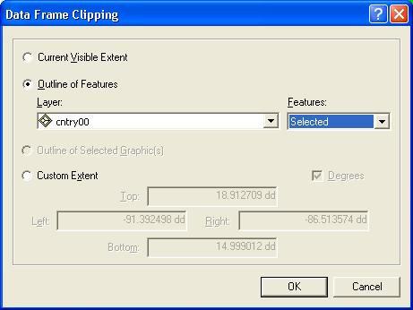
11 Clipping the Data Frame 11
12 Table Tools Tables Calculate Geometry VBA Functions in the Calculator Summarize Spatial Join Extract values to Points Domains 12


13 New with ArcGIS 9.2 Calculate Geometry For Shapefiles, or for calculating area/lengths in other units 13
")
14 VBA Functions in the Calculator [field1] & & [field2] Left ([field1],2) Now() 14

15 Labeling with a Time Stamp [Well_Prod] & & now() 15


16 Summarize How many wells are in each field? 16


17 Spatial Join Which wells are on sandy soil? 17

18 Make sure the two datasets are in the same projection. Spatial Join The point layer must be a feature class or a shape file (not an event layer, for example). 18


19 Is this surface elevation correct? Extract Values to Points 19


20 Requires a Spatial Analyst Example Extract Values to Points Make sure raster and point layer are in the same projection 20

21 Domains are used to constrain a column in the attribute table. Domains can only be created in Geodatabase Feature Classes Domains 21
22 Other Tools Editing Tools Samples 22
23 GIS EXTENSIONS / TOOLS 23

24 ESRI s Map Book can create a map series from a single map or aerial image with a point, line, or polygon layer set as an index. Downloading this extension adds a Map Series toolbar which has four useful tools in creating a Map Book. EDN Map Book This extension also creates a Map Book tab in ArcMap which displays the Map Series once created. From the new tab the user is able to doubleclick one page to see it individually in layout view, enable and disable map pages, also batch export and print these maps. 24

25 EDN Map Book The Map Book extension can be obtained on the ESRI Developer Network at: Using the site s search feature type mapbook to find the correct link. Choose the link called DS Map Book, the description includes the code. Download the visual basic files and follow the directions included in the download (Map Book Generation.doc) to launch the extension. 25

26 ESRI Mapping Center ESRI Mapping center is a free information-based site that gives detailed tips and useful downloads to create functional and great looking maps. In the Blog tab search articles by category. Ask a Cartographer gives the option to send an e- mail to receive advice or a suggestion. A thematic map library located on the Maps tab gives you the chance to see how these new map tips will help you create the desired look. 26
27 ESRI Mapping Center This resources is located at: ArcGIS Resources tab offers free downloads for styles, tools, expressions, and data. Other Resources has a list of data and presentations available to view from past conferences around the world. In order to Ask A Cartographer or post on the blog an ESRI global account login is required. 27
 Downloads images straight from the TerraServer website!")
28 Acquire DOQQ or DRG images for the visible extent of your map with the click of a button Choose image theme and resolution Choose output type (Raster Dataset or Raster Catalog) Downloads images straight from the TerraServer website! TerraServer Download 28


29 TerraServer Download Download the tool from the ESRI ArcScripts section: 29

30 ArcWeb Explorer 30
31 ArcWeb Explorer ArcWeb Explorer users can search the world map for places by name, address, city, state, zip, phone number, or URL. Able to choose map view type from street, hybrid, satellite, and data view. Can perform census analysis on map using data map view and choosing criteria. Able to run reports which can include buffer rings and drive time analysis. Includes tutorials on uploading shape files and creating map services within the developers guide. 31


32 ArcWeb Explorer ArcWeb Explorer is accessible free from ArcWeb Services. Visit choose the Use tab and launch the explorer 32
33 ArcGIS Explorer Visit Free and freely to distribute Download ArcGIS Explorer from to start exploring the world using many of the maps and layers provided by ESRI. ArcObject based 33
34 ArcGIS Explorer Use the ArcGIS Explorer Resource Center to access a variety of maps, layers, tasks, and results listed below. Maps Imagery Streets Shaded Relief Political Boundaries Protected Areas Historical Layers All above Transportation Physical Features Streets Political Names Boundaries Boundaries and Places Billboarded Place Labels Tasks Wikipedia Search Weather Finder Find Nearby Business Reports Results US State High Points US Highest and Lowest Points US National Parks US State Capitals and Facts 2008 ESRI UC Hotels 34
35 GIS REFERENCE TOOLS 35


36 Color Brewer 36
37 Color Brewer Visit Use Color Brewer to help select good color schemes for your maps. 35 basic schemes with over 250 different versions Color Diagnostic tool only, you cannot load your own data Developed by Cindy Brewer and Mark Harrower at Penn State and funded by the NSF Digital Government Program. 37

38 There are 3 steps to selecting your color schemes. Color Brewer 1. Pick the number of classes 2. Choose you legend type 3. Choose one the recommended color schemes. Informs you whether the color scheme you chose is: Color blind friendly Photocopy friendly LCD projector friendly Laptop friendly CRT friendly Color printing friendly 38

39 Color Brewer With Color Brewer you can also change other map elements such as background color, border color, cit symbols, and road network color to enhance your color scheme. 39

40 Type Brewer 40
41 Free Online Courses ESRI provides access to over 50 free online (Training Seminars) courses. All you have to do is create a ESRI Global Account. Go to and use the popular searches for free training. These training courses are also available at > Training > Course Catalog > Free Training (under Popular Searches). 41

42 Free Online Courses Most are 1 hour training seminars, with a recorded lecture and software demonstrations. There are several Web Courses available which provide a presentation, exercises and an exam. 42
43 EPSG European Petroleum Survey Group ( ) Consisted of specialists in geodesy, surveying, and cartography as they applied to oil exploration. The EPSG created the EPSG Geodetic Parameter Data Set a database of ellipsoids, datums, and coordinate systems. In 2005, the EPSG was absorbed by the International Association of Oil and Gas Producers (OGP). The dataset is now maintained by the OGP Surveying and Positioning Committee which meets twice yearly. 43

44 44
45 GIS DATA 45
46 ArcGIS Online Beta The ArcGIS Online Beta subscription is currently free to all users. Within ArcGIS Online 2D and 3D versions of shaded relief, geographically themed, aerial imagery, and many other types of maps can be found and utilized in your project. With ArcGIS Online you will always have recent data, as ESRI updates it twice a year. Easily add your own data to these maps and share them across an internet connection. Visit 46


47 ArcGIS Online Beta Registration is easy with ESRI s ArcGIS Online. A member can access the site by logging in with an ESRI Global Account or by creating a Global Account if one does not already exist. After registering to become a free subscriber the next step is to connect with the ESRI server. Instruction can be found on the ESRI website, and will be ed to you following the registration process. 47
48 Geography Network The Geography Network brings organized access to geographic information and is managed and supported by ESRI. It brings together users and providers to create a community of shared geographic information and services. Web services including: ArcWeb, Map Studio Static Maps, Map Files, Dynamic Data Downloadable data, offline data, clearinghouse data Publishing Participation 48

49 Geography Network Free Resources: Also: Geography Network Explorer : allows user to specify location and search additional criteria for data. USGS National Elevation Dataset shaded relief Census 2000 TIGER/ Line data Various Dynamic data Mapping applications Access is easy at : 49
50 SONRIS Strategic Online Natural Resources Information System SONIS is a no-cost data provider for the state of Louisiana. Select from either SONRIS "Classic", which has a form-based query capability, or SONRIS "Lite", an HTML-based capability designed for low-bandwidth users. Visit sonris- 50
51 Database Access: lease data, mineral reports, well history and reports, oil and gas production data, and much more. SONRIS Document Access to Electronic Images: access to scanned images and documents in electronic format. GIS Access to Interactive Maps: select layers and backgrounds to be placed on the geographically referenced map. Some of these include townships, oil and gas fields, wells, active leases, and coastal permits. The map can then be saved, extracted, or printed. 51

52 TNRIS Texas Natural Resources Information Systems Data Catalog has a search/download feature that is able to get aerial images by county quadrangle. Download statewide datasets including: natural regions, bathymetry, LandSat, StratMap, and many more. 52
 Download Texas data for")

53 TNRIS Strategic Mapping Program (StratMap) Download Texas data for Transportation Political Boundaries Hydrography Elevation Soil Surveys Digital Imagery 53
54 Other useful data sites Geoscience Australia Alaska State Geospatial Data Clearinghouse KYGIS BLM.gov Colorado Oil and Gas Conservation Commission 54
55 Thank You 55
56 Please note: This presentation was used as speaker s notes for the 2008 Petroleum User Group Conference on Feb. 27, 2008 in Houston, TX. This material is not intended as course material nor reference material, but simply as speaker s notes. This presentation may be used by an individual, but not posted on any website nor used in a public setting nor for profit. The.PDF version of this document does not display any of the animations that were in the original talk, so some of the slides may not display well. For permission/access to the entire power point presentation in its complete form, please contact info@teachmegis.com. 56
GIS CONCEPTS ARCGIS METHODS AND. 3 rd Edition, July David M. Theobald, Ph.D. Warner College of Natural Resources Colorado State University
 GIS CONCEPTS AND ARCGIS METHODS 3 rd Edition, July 2007 David M. Theobald, Ph.D. Warner College of Natural Resources Colorado State University Copyright Copyright 2007 by David M. Theobald. All rights
Task 1: Start ArcMap and add the county boundary data from your downloaded dataset to the data frame.
 Exercise 6 Coordinate Systems and Map Projections The following steps describe the general process that you will follow to complete the exercise. Specific steps will be provided later in the step-by-step
UNIT 4: USING ArcGIS. Instructor: Emmanuel K. Appiah-Adjei (PhD) Department of Geological Engineering KNUST, Kumasi
 Department of Geological Engineering KNUST, Kumasi") UNIT 4: USING ArcGIS Instructor: Emmanuel K. Appiah-Adjei (PhD) Department of Geological Engineering KNUST, Kumasi Getting to Know ArcGIS ArcGIS is an integrated collection of GIS software products ArcGIS
UNIT 4: USING ArcGIS Instructor: Emmanuel K. Appiah-Adjei (PhD) Department of Geological Engineering KNUST, Kumasi Getting to Know ArcGIS ArcGIS is an integrated collection of GIS software products ArcGIS
v WMS Tutorials GIS Module Importing, displaying, and converting shapefiles Required Components Time minutes
 v. 11.0 WMS 11.0 Tutorial Importing, displaying, and converting shapefiles Objectives This tutorial demonstrates how to import GIS data, visualize it, and convert it into WMS coverage data that could be
GED 554 IT & GIS. Lecture 6 Exercise 5. May 10, 2013
 GED 554 IT & GIS Lecture 6 Exercise 5 May 10, 2013 Free GIS data sources ******************* Mapping numerical data & Symbolization ******************* Exercise: Making maps for presentation GIS DATA SOFTWARE
Learning ArcGIS: Introduction to ArcCatalog 10.1
 Learning ArcGIS: Introduction to ArcCatalog 10.1 Estimated Time: 1 Hour Information systems help us to manage what we know by making it easier to organize, access, manipulate, and apply knowledge to the
Map image from the Atlas of Oregon (2nd. Ed.), Copyright 2001 University of Oregon Press
, Copyright 2001 University of Oregon Press") Map Layout and Cartographic Design with ArcGIS Desktop Matthew Baker ESRI Educational Services Redlands, CA Education UC 2008 1 Seminar overview General map design principles Working with map elements
Map Layout and Cartographic Design with ArcGIS Desktop Matthew Baker ESRI Educational Services Redlands, CA Education UC 2008 1 Seminar overview General map design principles Working with map elements
ArcGIS 9 ArcGIS StreetMap Tutorial
 ArcGIS 9 ArcGIS StreetMap Tutorial Copyright 2001 2008 ESRI All Rights Reserved. Printed in the United States of America. The information contained in this document is the exclusive property of ESRI. This
Using the Stock Hydrology Tools in ArcGIS
 Using the Stock Hydrology Tools in ArcGIS This lab exercise contains a homework assignment, detailed at the bottom, which is due Wednesday, October 6th. Several hydrology tools are part of the basic ArcGIS
VCCS Geospatial Institute 2011
 John McGee Jennifer McKee With support from: NSF DUE-0903270 Acquiring and Downloading Digital Data in partnership with: Geospatial Technician Education Through Virginia s Community Colleges (GTEVCC) Review
Task 1: Open ArcMap and activate the Spatial Analyst extension.
 Exercise 10 Spatial Analyst The following steps describe the general process that you will follow to complete the exercise. Specific steps will be provided later in the step-by-step instructions component
COURSE SCHEDULE, GRADING, and READINGS
 COURSE SCHEDULE, GRADING, and READINGS Note: All academic classes will be held in the GIS lab at Royal Thimphu College. These dates are listed here. Other days will involve travel or days off, and the
ArcGIS Pro: Essential Workflows STUDENT EDITION
 ArcGIS Pro: Essential Workflows STUDENT EDITION Copyright 2018 Esri All rights reserved. Course version 6.0. Version release date August 2018. Printed in the United States of America. The information contained
Introduction to ArcGIS Server - Creating and Using GIS Services. Mark Ho Instructor Washington, DC
 Introduction to ArcGIS Server - Creating and Using GIS Services Mark Ho Instructor Washington, DC Technical Workshop Road Map Product overview Building server applications GIS services Developer Help resources
Lecture 2. A Review: Geographic Information Systems & ArcGIS Basics
 Lecture 2 A Review: Geographic Information Systems & ArcGIS Basics GIS Overview Types of Maps Symbolization & Classification Map Elements GIS Data Models Coordinate Systems and Projections Scale Geodatabases
Introduction to Coastal GIS
 Introduction to Coastal GIS Event was held on Tues, 1/8/13 - Thurs, 1/10/13 Time: 9:00 am to 5:00 pm Location: Roger Williams University, Bristol, RI Audience: The intended audiences for this course are
Compilation of GIS data for the Lower Brazos River basin
 Compilation of GIS data for the Lower Brazos River basin Francisco Olivera, Ph.D., P.E. Srikanth Koka Lauren Walker Aishwarya Vijaykumar Department of Civil Engineering December 5, 2011 Contents Brief
(THIS IS AN OPTIONAL BUT WORTHWHILE EXERCISE)
") PART 2: Analysis in ArcGIS (THIS IS AN OPTIONAL BUT WORTHWHILE EXERCISE) Step 1: Start ArcCatalog and open a geodatabase If you have a shortcut icon for ArcCatalog on your desktop, double-click it to start
PART 2: Analysis in ArcGIS (THIS IS AN OPTIONAL BUT WORTHWHILE EXERCISE) Step 1: Start ArcCatalog and open a geodatabase If you have a shortcut icon for ArcCatalog on your desktop, double-click it to start
SRJC Applied Technology 54A Introduction to GIS
 SRJC Applied Technology 54A Introduction to GIS Overview Lecture of Geographic Information Systems Fall 2004 Santa Rosa Junior College Presented By: Tim Pudoff, GIS Coordinator, County of Sonoma, Information
Geospatial Data Sources. SLO GIS User Group June 8, 2010
 Geospatial Data Sources SLO GIS User Group June 8, 2010 Presenters Drew Decker USGS Southern California Geospatial Liaison Kelly Bobbitt Mike Bobbitt & Associates Joe Larson Cal Fire Peter Meertens Regional
DP Project Development Pvt. Ltd.
 Dear Sir/Madam, Greetings!!! Thanks for contacting DP Project Development for your training requirement. DP Project Development is leading professional training provider in GIS technologies and GIS application
Acknowledgments xiii Preface xv. GIS Tutorial 1 Introducing GIS and health applications 1. What is GIS? 2
 Acknowledgments xiii Preface xv GIS Tutorial 1 Introducing GIS and health applications 1 What is GIS? 2 Spatial data 2 Digital map infrastructure 4 Unique capabilities of GIS 5 Installing ArcView and the
GIS CONCEPTS ARCGIS METHODS AND. 2 nd Edition, July David M. Theobald, Ph.D. Natural Resource Ecology Laboratory Colorado State University
 GIS CONCEPTS AND ARCGIS METHODS 2 nd Edition, July 2005 David M. Theobald, Ph.D. Natural Resource Ecology Laboratory Colorado State University Copyright Copyright 2005 by David M. Theobald. All rights
Write a report (6-7 pages, double space) on some examples of Internet Applications. You can choose only ONE of the following application areas:
 on some examples of Internet Applications. You can choose only ONE of the following application areas:") UPR 6905 Internet GIS Homework 1 Yong Hong Guo September 9, 2008 Write a report (6-7 pages, double space) on some examples of Internet Applications. You can choose only ONE of the following application
UPR 6905 Internet GIS Homework 1 Yong Hong Guo September 9, 2008 Write a report (6-7 pages, double space) on some examples of Internet Applications. You can choose only ONE of the following application
Lecture 7: GIS Data Capture and Metadata
 Lecture 7: GIS Data Capture and Metadata Section I: Overview of GIS Data Capture As you read this lecture think about the type of data capture and how metadata can help with your final project. Introduction
Utilizing Data from American FactFinder with TIGER/Line Shapefiles in ArcGIS
 Utilizing Data from American FactFinder with TIGER/Line Shapefiles in ArcGIS Web Adams, GISP Data Dissemination Specialist U.S. Census Bureau New York Regional Office 1 What We Do Decennial Census Every
Esri s Living Atlas of the World Community Maps
 Esri s Living Atlas of the World Community Maps Seth Sarakaitis Wednesday May 7, 2014 ArcGIS Living Atlas Concept Living Atlas Content Tour Contributing to the Living Atlas (Community Maps) Seth Sarakaitis
In this exercise we will learn how to use the analysis tools in ArcGIS with vector and raster data to further examine potential building sites.
 GIS Level 2 In the Introduction to GIS workshop we filtered data and visually examined it to determine where to potentially build a new mixed use facility. In order to get a low interest loan, the building
Incorporating ArcGIS Pro in your Curriculum
 AAG, Boston 2017 April 5, 2017 Incorporating ArcGIS Pro in your Curriculum Geri Miller Agenda Concerns Acknowledged Learning curve ArcGIS Pro does not have all the tools (perception) Licensing and offline
Exercise 2: Working with Vector Data in ArcGIS 9.3
 Exercise 2: Working with Vector Data in ArcGIS 9.3 There are several tools in ArcGIS 9.3 used for GIS operations on vector data. In this exercise we will use: Analysis Tools in ArcToolbox Overlay Analysis
GIS and Forest Engineering Applications FE 257 Lecture and laboratory, 3 credits
 GIS and Forest Engineering Applications FE 257 Lecture and laboratory, 3 credits Instructor: Michael Wing Associate Professor Forest Engineering, Resources, and Management Oregon State University Crop
Lecture 9: Reference Maps & Aerial Photography
 Lecture 9: Reference Maps & Aerial Photography I. Overview of Reference and Topographic Maps There are two basic types of maps? Reference Maps - General purpose maps & Thematic Maps - maps made for a specific
NR402 GIS Applications in Natural Resources
 NR402 GIS Applications in Natural Resources Lesson 1 Introduction to GIS Eva Strand, University of Idaho Map of the Pacific Northwest from http://www.or.blm.gov/gis/ Welcome to NR402 GIS Applications in
The Geodatabase Working with Spatial Analyst. Calculating Elevation and Slope Values for Forested Roads, Streams, and Stands.
 GIS LAB 7 The Geodatabase Working with Spatial Analyst. Calculating Elevation and Slope Values for Forested Roads, Streams, and Stands. This lab will ask you to work with the Spatial Analyst extension.
Data Structures & Database Queries in GIS
 Data Structures & Database Queries in GIS Objective In this lab we will show you how to use ArcGIS for analysis of digital elevation models (DEM s), in relationship to Rocky Mountain bighorn sheep (Ovis
GIS Lecture 5: Spatial Data
 GIS Lecture 5: Spatial Data GIS 1 Outline Vector Data Formats Raster Data Formats Map Projections Coordinate Systems US Census geographic files US Census data files GIS Data Sources GIS 2 Vector Data Formats
ISU GIS CENTER S ARCSDE USER'S GUIDE AND DATA CATALOG
 ISU GIS CENTER S ARCSDE USER'S GUIDE AND DATA CATALOG 2 TABLE OF CONTENTS 1) INTRODUCTION TO ARCSDE............. 3 2) CONNECTING TO ARCSDE.............. 5 3) ARCSDE LAYERS...................... 9 4) LAYER
Esri UC2013. Technical Workshop.
 Esri International User Conference San Diego, California Technical Workshops July 9, 2013 CAD: Introduction to using CAD Data in ArcGIS Jeff Reinhart & Phil Sanchez Agenda Overview of ArcGIS CAD Support
GeoWEPP Tutorial Appendix
 GeoWEPP Tutorial Appendix Chris S. Renschler University at Buffalo - The State University of New York Department of Geography, 116 Wilkeson Quad Buffalo, New York 14261, USA Prepared for use at the WEPP/GeoWEPP
EnvSci 360 Computer and Analytical Cartography
 EnvSci 360 Computer and Analytical Cartography Lecture 7 Mapping Images, Surfaces, and 3-D Data Brief Overview of Imagery What is Imagery? A spatial data model that defines space as an array of equally
ARCGIS TRAINING AT KU GIS LABS: INTRODUCTION TO GIS: EXPLORING ARCCATALOG AND ARCGIS TOOLS
 PHASE 1_3 rd SESSION ARCGIS TRAINING AT KU GIS LABS: INTRODUCTION TO GIS: EXPLORING ARCCATALOG AND ARCGIS TOOLS 3 rd SESSION REPORT: 25 TH -27 TH JUNE 2014 SCHOOL OF ENVIRONMENTAL STUDIES COMPUTER LAB
Environmental Systems Research Institute
 Introduction to ArcGIS ESRI Environmental Systems Research Institute Redlands, California 2 ESRI GIS Development Arc/Info (coverage model) Versions 1-7 from 1980 1999 Arc Macro Language (AML) ArcView (shapefile
GIS for the Beginner on a Budget
 GIS for the Beginner on a Budget Andre C. Bally, RLA, GIS Coordinator, Harris County Public Infrastructure Department Engineering Division This presentation, GIS for Beginners on a Budget. will briefly
Determining the Location of the Simav Fault
 Lindsey German May 3, 2012 Determining the Location of the Simav Fault 1. Introduction and Problem Formulation: The issue I will be focusing on involves interpreting the location of the Simav fault in
GIS PORTFOLIO MOHAMED MAGDY MOHAMED HUSSAIN GIS ENGINEER. UWF GIS ONLINE CERTIFICATE GIS Internship (GIS4944)
") 2012 GIS PORTFOLIO MOHAMED MAGDY MOHAMED HUSSAIN GIS ENGINEER UWF GIS ONLINE CERTIFICATE GIS Internship (GIS4944) Portfolio Table of Contents Subject... Page Personal statement/mission/philosophy... 1
2012 GIS PORTFOLIO MOHAMED MAGDY MOHAMED HUSSAIN GIS ENGINEER UWF GIS ONLINE CERTIFICATE GIS Internship (GIS4944) Portfolio Table of Contents Subject... Page Personal statement/mission/philosophy... 1
Fundamentals of ArcGIS Desktop Pathway
 Fundamentals of ArcGIS Desktop Pathway Table of Contents ArcGIS Desktop I: Getting Started with GIS 3 ArcGIS Desktop II: Tools and Functionality 5 Understanding Geographic Data 8 Understanding Map Projections
Week 8 Cookbook: Review and Reflection
 : Review and Reflection Week 8 Overview 8.1) Review and Reflection 8.2) Making Intelligent Maps: The map sheet as a blank canvas 8.3) Making Intelligent Maps: Base layers and analysis layers 8.4) ArcGIS
Introduction to Geographic Information Systems (GIS): Environmental Science Focus
: Environmental Science Focus") Introduction to Geographic Information Systems (GIS): Environmental Science Focus September 9, 2013 We will begin at 9:10 AM. Login info: Username:!cnrguest Password: gocal_bears Instructor: Domain: CAMPUS
Introduction to Geographic Information Systems (GIS): Environmental Science Focus September 9, 2013 We will begin at 9:10 AM. Login info: Username:!cnrguest Password: gocal_bears Instructor: Domain: CAMPUS
Lecture 2. Introduction to ESRI s ArcGIS Desktop and ArcMap
 Lecture 2 Introduction to ESRI s ArcGIS Desktop and ArcMap Outline ESRI What is ArcGIS? ArcGIS Desktop ArcMap Overview Views Layers Attribute Tables Help! Scale Tips and Tricks ESRI Environmental Systems
Geospatial Intelligence
 Geospatial Intelligence Geospatial analysis has existed as long as humans have made and studied maps but its importance to the intelligence community has skyrocketed in the past several years, with Unmanned
Abstract: Contents. Literature review. 2 Methodology.. 2 Applications, results and discussion.. 2 Conclusions 12. Introduction
 Abstract: Landfill is one of the primary methods for municipal solid waste disposal. In order to reduce the environmental damage and to protect the public health and welfare, choosing the site for landfill
GIS Workshop UCLS_Fall Forum 2014 Sowmya Selvarajan, PhD TABLE OF CONTENTS
 TABLE OF CONTENTS TITLE PAGE NO. 1. ArcGIS Basics I 2 a. Open and Save a Map Document 2 b. Work with Map Layers 2 c. Navigate in a Map Document 4 d. Measure Distances 4 2. ArcGIS Basics II 5 a. Work with
GIS Data Acquisition. Lauren Walker
 GIS Data Acquisition Lauren Walker Table of Contents Soil Data Mart - SSURGO... 3 Background... 3 Data Collection... 3 Confirming Projection... 8 Helpful Hints for Soil Data Mart... 9 More Information...
Using MAGIC to Access Spatial Imagery: Putting ER Mapper Image Web Server, ArcIMS and MrSID to work in your Library
 Using MAGIC to Access Spatial Imagery: Putting ER Mapper Image Web Server, ArcIMS and MrSID to work in your Library Patrick McGlamery Shirley Quintero University of Connecticut Libraries Building the Connecticut
Display data in a map-like format so that geographic patterns and interrelationships are visible
 Vilmaliz Rodríguez Guzmán M.S. Student, Department of Geology University of Puerto Rico at Mayagüez Remote Sensing and Geographic Information Systems (GIS) Reference: James B. Campbell. Introduction to
Teaching GIS for Land Surveying
 Teaching GIS for Land Surveying Zhanjing (John) Yu Evergreen Valley College, San Jose, California James Crossfield California State University at Fresno, Fresno California 7/13/2006 1 Outline of the Presentation
SoilView: Development of a Custom GIS Application for Publishing Soil Surveys
 SoilView: Development of a Custom GIS Application for Publishing Soil Surveys Allan Johnson and Mike Wigginton Abstract Currently, digital soils information can be obtained from many sources. Numerous
Esri EADA10. ArcGIS Desktop Associate. Download Full Version :
 Esri EADA10 ArcGIS Desktop Associate Download Full Version : http://killexams.com/pass4sure/exam-detail/eada10 Question: 85 Which format is appropriate for exporting map documents that require vector layers
Vector Analysis: Farm Land Suitability Analysis in Groton, MA
 Vector Analysis: Farm Land Suitability Analysis in Groton, MA Written by Adrienne Goldsberry, revised by Carolyn Talmadge 10/9/2018 Introduction In this assignment, you will help to identify potentially
Exercise 3: GIS data on the World Wide Web
 Exercise 3: GIS data on the World Wide Web These web sites are a few examples of sites that are serving free GIS data. Many other sites exist. Search in Google or other search engine to find GIS data for
Delineation of high landslide risk areas as a result of land cover, slope, and geology in San Mateo County, California
 Delineation of high landslide risk areas as a result of land cover, slope, and geology in San Mateo County, California Introduction Problem Overview This project attempts to delineate the high-risk areas
Lecture 3 GIS outputs. Dr. Zhang Spring, 2017
 Lecture 3 GIS outputs Dr. Zhang Spring, 2017 Model of the course Using and making maps Navigating GIS maps Map design Working with spatial data Geoprocessing Spatial data infrastructure Digitizing File
SCHOOL OF ENGINEERING AND TECHNOLOGY COMPUTER LAB
 PHASE 1_6 TH SESSION ARCGIS TRAINING AT KU GIS LABS: INTRODUCTION TO GIS: EXPLORING ARCCATALOG AND ARCGIS TOOLS 6 TH SESSION REPORT: 3 RD -5 TH SEPTEMBER 2014 SCHOOL OF ENGINEERING AND TECHNOLOGY COMPUTER
WlLPEN L. GORR KRISTEN S. KURLAND. Universitats- und Landesbibliothek. Bibliothek Architektur und Stadtebau ESRI
 hj WlLPEN L. GORR KRISTEN S. KURLAND Universitats- und Landesbibliothek Darmstadt Bibliothek Architektur und Stadtebau ESRI Contents Acknowledgments Preface xvii XV GIS Tutorial 1 Introduction Launch ArcMap
Delineation of Watersheds
 Delineation of Watersheds Adirondack Park, New York by Introduction Problem Watershed boundaries are increasingly being used in land and water management, separating the direction of water flow such that
GEOGRAPHIC INFORMATION SYSTEMS AND IT SOLUTIONS FOR THE ENVIRONMENT
 GEOGRAPHIC INFORMATION SYSTEMS AND IT SOLUTIONS FOR THE ENVIRONMENT Mission We focus on Solutions is a worldwide operating business offering Geographic Information Systems and IT solutions to assist environmental
An ArcIMS based interactive map for SeaWorld San Antonio
 An ArcIMS based interactive map for SeaWorld San Antonio Morgan K. Dean Advanced GIS, Earth and Environmental Science Department University of Texas at San Antonio One UTSA Circle, San Antonio, TX. 78249,
Presenting Tree Inventory. Tomislav Sapic GIS Technologist Faculty of Natural Resources Management Lakehead University
 Presenting Tree Inventory Tomislav Sapic GIS Technologist Faculty of Natural Resources Management Lakehead University Suggested Options 1. Print out a Google Maps satellite image of the inventoried block
GEOG 487 Lesson 7: Step-by-Step Activity
 GEOG 487 Lesson 7: Step-by-Step Activity Part I: Review the Relevant Data Layers and Organize the Map Document In Part I, we will review the data and organize the map document for analysis. 1. Unzip the
GED 554 IT & GIS INTRODUCTION TO THE COURSE CHAPTER 1
 GED 554 IT & GIS INTRODUCTION TO THE COURSE CHAPTER 1 March 1, 2013 Lines before starting class 1. Initial Introductions 2. Usage of the building 3. Assistance 4. Timetable 5. Curriculum 6. Introduction
Designing GIS Databases to Support Mapping and Map Production Charlie Frye, ESRI Redlands Aileen Buckley, ESRI Redlands
 Designing GIS Databases to Support Mapping and Map Production Charlie Frye, ESRI Redlands Aileen Buckley, ESRI Redlands 1 Designing GIS Databases to Support Mapping and Map Production Charlie Frye, ESRI
Cartography with Esri Production Mapping
 Cartography with Esri Production Mapping All rights reserved. Course version 1.3. Version release date September 2015. Printed in the United States of America. The information contained in this document
Working with ArcGIS: Classification
 Working with ArcGIS: Classification 2 Abbreviations D-click R-click TOC Double Click Right Click Table of Content Introduction The benefit from the use of geographic information system (GIS) software is
These modules are covered with a brief information and practical in ArcGIS Software and open source software also like QGIS, ILWIS.
 Online GIS Training and training modules covered are: 1. ArcGIS, Analysis, Fundamentals and Implementation 2. ArcGIS Web Data Sharing 3. ArcGIS for Desktop 4. ArcGIS for Server These modules are covered
 www.goldensoftware.com Why Create a Thematic Map? A thematic map visually represents the geographic distribution of data. MapViewer will help you to: understand demographics define sales or insurance territories
A Review: Geographic Information Systems & ArcGIS Basics
 A Review: Geographic Information Systems & ArcGIS Basics Geographic Information Systems Geographic Information Science Why is GIS important and what drives it? Applications of GIS ESRI s ArcGIS: A Review
Data Aggregation with InfraWorks and ArcGIS for Visualization, Analysis, and Planning
 Data Aggregation with InfraWorks and ArcGIS for Visualization, Analysis, and Planning Stephen Brockwell President, Brockwell IT Consulting, Inc. Join the conversation #AU2017 KEYWORD Class Summary Silos
Welcome to NR502 GIS Applications in Natural Resources. You can take this course for 1 or 2 credits. There is also an option for 3 credits.
 Welcome to NR502 GIS Applications in Natural Resources. You can take this course for 1 or 2 credits. There is also an option for 3 credits. The 1st credit consists of a series of readings, demonstration,
Getting Started with Community Maps
 Esri International User Conference San Diego, California Technical Workshops July 24, 2012 Getting Started with Community Maps Shane Matthews and Tamara Yoder Topics for this Session ArcGIS is a complete
ST-Links. SpatialKit. Version 3.0.x. For ArcMap. ArcMap Extension for Directly Connecting to Spatial Databases. ST-Links Corporation.
 ST-Links SpatialKit For ArcMap Version 3.0.x ArcMap Extension for Directly Connecting to Spatial Databases ST-Links Corporation www.st-links.com 2012 Contents Introduction... 3 Installation... 3 Database
Performing Advanced Cartography with Esri Production Mapping
 Esri International User Conference San Diego, California Technical Workshops July 25, 2012 Performing Advanced Cartography with Esri Production Mapping Tania Pal & Madhura Phaterpekar Agenda Outline generic
Introducing ArcGIS Engine
 1 Introducing ArcGIS Engine ESRI ArcGIS Engine is a platform for building custom standalone geographic information system (GIS) applications that support multiple application programming interfaces (APIs),
The File Geodatabase API. Craig Gillgrass Lance Shipman
 The File Geodatabase API Craig Gillgrass Lance Shipman Schedule Cell phones and pagers Please complete the session survey we take your feedback very seriously! Overview File Geodatabase API - Introduction
Introduction. Project Summary In 2014 multiple local Otsego county agencies, Otsego County Soil and Water
 Introduction Project Summary In 2014 multiple local Otsego county agencies, Otsego County Soil and Water Conservation District (SWCD), the Otsego County Planning Department (OPD), and the Otsego County
GIS Software. Evolution of GIS Software
 GIS Software The geoprocessing engines of GIS Major functions Collect, store, mange, query, analyze and present Key terms Program collections of instructions to manipulate data Package integrated collection
Arcgis Tutorial Manual READ ONLINE
 Arcgis Tutorial Manual READ ONLINE ArcGIS Desktop 10 Trial Help - Note: The Quick Start Guide contains instructions that do not pertain to the trial edition. Many tutorials are found in the ArcGIS Desktop
Visual Studies Exercise, Assignment 07 (Architectural Paleontology) Geographic Information Systems (GIS), Part II
 Geographic Information Systems (GIS), Part II") ARCH1291 Visual Studies II Week 8, Spring 2013 Assignment 7 GIS I Prof. Alihan Polat Visual Studies Exercise, Assignment 07 (Architectural Paleontology) Geographic Information Systems (GIS), Part II Medium:
ARCH1291 Visual Studies II Week 8, Spring 2013 Assignment 7 GIS I Prof. Alihan Polat Visual Studies Exercise, Assignment 07 (Architectural Paleontology) Geographic Information Systems (GIS), Part II Medium:
GIS Lecture 4: Data. GIS Tutorial, Third Edition GIS 1
 GIS Lecture 4: Data GIS 1 Outline Data Types, Tables, and Formats Geodatabase Tabular Joins Spatial Joins Field Calculator ArcCatalog Functions GIS 2 Data Types, Tables, Formats GIS 3 Directly Loadable
Getting Started with Military Analyst for ArcGIS 9.2
 Getting Started with Military Analyst for ArcGIS 9.2 Copyright 2006 ESRI All rights reserved. Printed in the United States of America. The information contained in this document is the exclusive property
Expanding Canada s Rail Network to Meet the Challenges of the Future
 Expanding Canada s Rail Network to Meet the Challenges of the Future Lesson Overview Rail may become a more popular mode of transportation in the future due to increased population, higher energy costs,
GIS Data Acquisition
 GIS Data Acquisition Lauren Walker Department of Civil Engineering Texas A&M University Aishwarya Vijaykumar December 5, 2011 Table of Contents Soil Data Mart - SSURGO... 2 Background... 2 Data Collection...
GIS and Forest Engineering Applications FE 357 Lecture: 2 hours Lab: 2 hours 3 credits
 GIS and Forest Engineering Applications FE 357 Lecture: 2 hours Lab: 2 hours 3 credits Instructor: Michael Wing Assistant Professor Forest Engineering Department Oregon State University Peavy Hall 275
Problems and Challenges
 2018 Esri Petroleum GIS Conference Problems and Challenges May 9 10, 2018 Houston, Texas George R. Brown Convention Center Disunity of drawing standards and format Large amount of work in Cartography,
GIS: Introductory Guide to MapPlace. Workshop Agenda. How the Maps Work. Geographic Information Systems. -The MapPlace is a web GIS application
 1 Introductory Guide to MapPlace Workshop 2007 Larry Jones MapPlace & Geoscience Databases Pat Desjardins Corporate GIS Gib McArthur Manager, Resource Information Kirk Hancock MINFILE Geologist Ward Kilby
Introduction to the 176A labs and ArcGIS Purpose of the labs
 Introduction to the 176A labs and ArcGIS Purpose of the labs Acknowledgement: Slides by David Maidment, U Texas-Austin and Francisco Olivera (TAMU) Hands-on experience with a leading software package Introduction
1) make sure folks know what s available in terms of geospatial data and resources that could contribute to their decision support toolkits;
 make sure folks know what s available in terms of geospatial data and resources that could contribute to their decision support toolkits;") Introduction 1 2001 It was born out of the recognition that several of the regions prominent resource management agencies have similar, if not shared, requirements for GIS data. Some of the underlying
Introduction 1 2001 It was born out of the recognition that several of the regions prominent resource management agencies have similar, if not shared, requirements for GIS data. Some of the underlying
Applied Cartography and Introduction to GIS GEOG 2017 EL. Lecture-2 Chapters 3 and 4
 Applied Cartography and Introduction to GIS GEOG 2017 EL Lecture-2 Chapters 3 and 4 Vector Data Modeling To prepare spatial data for computer processing: Use x,y coordinates to represent spatial features
ARMY ITAM GIS: Automating Standard Army Training Map Production
 ARMY ITAM GIS: Automating Standard Army Training Map Production Douglas Willets ITAM Western Regional Support Center, Center for Environmental Management of Military Lands, Colorado State University, Fort
Sources of Imagery and GIS Data Layers (Last updated October 2005)
") Sources of Imagery and GIS Data Layers (Last updated October 2005) The question of where to find data is one often asked by beginners in precision agriculture and other geospatial projects. The following
Sources of Imagery and GIS Data Layers (Last updated October 2005) The question of where to find data is one often asked by beginners in precision agriculture and other geospatial projects. The following
GEOG 508 GEOGRAPHIC INFORMATION SYSTEMS I KANSAS STATE UNIVERSITY DEPARTMENT OF GEOGRAPHY FALL SEMESTER, 2002
 GEOG 508 GEOGRAPHIC INFORMATION SYSTEMS I KANSAS STATE UNIVERSITY DEPARTMENT OF GEOGRAPHY FALL SEMESTER, 2002 Course Reference #: 13210 Meeting Time: TU 2:05pm - 3:20 pm Meeting Place: Ackert 221 Remote