Rethinking Ocean Governance as if Ecosystems Mattered
|
|
|
- Joseph Shields
- 5 years ago
- Views:
Transcription

1 Rethinking Ocean Governance as if Ecosystems Mattered Gail Osherenko Marine Science Institute University of California Santa Barbara Marine Protected Areas Federal Advisory Committee October 10, Newport, Oregon Hotel in Moorea Courtesy of Heike Schroeder


2 21 st Century: The transparent ocean Satellite tags, ROVs, underwater cameras Deepsea vent exploration for minerals and pharmaceuticals Source: Nautalus Minerals Source:
3 Outline Who owns the oceans? What is the role of government? Diagnoses of the problem Place-based approaches to Ecosystem- Based Management MSP and Ocean Zoning How do we transition to ecosystem based, sea use management?
4 Outline Who owns the oceans? What is the role of government? Diagnoses of the problem Place-based approaches to Ecosystem- Based Management MSP and Ocean Zoning How do we transition to ecosystem based, sea use management?


5 Who owns the oceans? Floating hotel ( permanently moored ) All photos: GBRMPA Floating day-use tourism pontoons ( permanently moored )
6 Marine park is world's biggest KRT/ AP/ AAP 16jun06 CALIFORNIA -- US President George W Bush is establishing what is being billed as the largest protected ocean area in the world. Bush to Create World's Largest Marine Protected Area Near Hawaii A swath of the Pacific near Hawaii will be the largest such preserve in the world. The president was inspired to act by a Cousteau film


7 Technology creates opportunity and pressure for privatization. Photo courtesy of Nautilus Minerals
8 Property rights Private property bundle of rights belongs to identifiable owner (legal person) Public property bundle of rights belongs to the government or state Common property bundle of rights belongs to a group
9
10 Outline Who owns the oceans? What is the role of government? Diagnoses of the problem Place-based approaches to Ecosystem- Based Management MSP and Ocean Zoning How do we transition to ecosystem based, sea use management?
11 Public trust or trusteeship 1. Common property resources are held in trust for the benefit of the community (current and future). 2. They cannot be permanently converted to private property. 3. The government protects the productive capacity of the trust resources. 4. Private uses are permitted but must be consistent with public trust purposes. 5. Purposes change to reflect societies changing knowledge, perception, and values.

12 Quite possibly, by 2010 a map of the United States EEZ will look more like the plat of a subdivision than a map of ocean space. James E. Bailey, III, 1985
13 Rights and Rules are social constructs that reflect societies changing concepts A future scenario from the Belgian Part of North Sea planning project: Wind farms, fisheries, and sand & gravel extraction in exclusive concession zones
14 Key distinctions Imperium exercise of authority Under US Constitution, the federal government exercises rights under the commerce clause Dominium property rights Under the US Constitution, the federal government exercises rights under the property clause

15 Federal/State Battle over OCS 1947 Supreme Court decisions: United States v. California United States v. Louisiana
16 Justice Black writing for the majority in United States v. California (1947) One may choose to say that the United States has national dominion over navigable streams. But the power to regulate commerce over these streams, and its continued exercise, do not change the imperium of the United States into dominium over the land below the waters.
17 New Discourses on Ocean Rights: Property Rights, the Public Trust and Ocean Governance Forthcoming in JELL Journal of Environmental Law & Litigation, spring 2007 Available in preprint at
18 Key Points 1. There is no need to privatize common property. 2. Governments can use regulatory authority to provide security for activities requiring substantial long-term investment. 3. The public trust doctrine is flexible enough to incorporate protection of the public interest in ecosystem services.
19 Outline Who owns the oceans? What is the role of government? Diagnoses of the problem Place-based approaches to Ecosystem- Based Management MSP and Ocean Zoning How do we transition to ecosystem based, sea use management?

20
21 Diagnosis of the Problem Fragmentation of management authority Spatial mismatches between scale of governance and ecological system. Temporal mismatches between governance and ecological processes.

22 Marine spatial planning and ocean zoning will be useful tools for allocating ocean space and resolving conflicts.


23 Next Steps for California Ocean Management California and the World Ocean Conference September 20, 2006 NCEAS Working Group


24 More Important Ecosystem-based management requires us to deal with an unruly species
25 Outline Who owns the oceans? What is the role of government? Diagnoses of the problem Place-based approaches to Ecosystem- Based Management MSP and Ocean Zoning How do we transition to ecosystem based, sea use management?


26 Marine Activities Commercial and recreational fisheries Commerce and transportation Sand and gravel mining Dredged material management Cable/Pipeline/Structure Siting Energy Infrastructure Tourism and Recreation Aquaculture Military Research and Education

27 Proposed Projects Wind Power LNG Tide farm Aquaculture Mining Desalination

28


29 Zoning spectrum for multiple use Boating, Diving, photography Line fishing Trawling
30 A Simple Zoning System No-go zones (e.g., seabird nesting colonies) so sensitive that humans (except permitted researchers) are prohibited (very limited) Marine reserves that prohibit all extractive and other harmful uses Buffer zones that surround or adjoin no-go and marine reserve zones and allow extractive uses that do not degrade habitats General use zones that allow a wide range of activities (probably a plurality of the area)
31 Examples of Marine Spatial Planning Great Barrier Reef Marine Park Florida Keys National Marine Sanctuary Eastern Scotian Shelf Master Plan for Belgian Part of the North Sea Integrated Management Plan for North Sea EEZ and Territorial Sea Planning Irish Sea Pilot Project Territorial Sea Zoning Australia United States Canada Belgium The Netherlands Germany United Kingdom China
32 Acronyms EB-SUM = Ecosystem-Based, Sea Use Management MSP = Marine Spatial Planning OZ = Ocean Zoning
33 Hierarchy Ecosystem-based, Sea Use Management Marine Spatial Planning Ocean Zoning Plan Use Permits

34 Southern California California Area of Detail Crowder et al Science. August 4, 2006.

 - Zones for Sand & Gravel exploitation -")
 - Marine Protected Areas Source:")
35 MSP IMPLEMENTATION - BELGIUM - - January 1999 Law on Protection of Marine Environment - Masterplan for the Belgian North Sea Phase 1 (2004) - Zones for Sand & Gravel exploitation - Zones for Wind Energy exploitation Phase 2 ( ) - Marine Protected Areas Source: Maes, F. et al.
 - Control Zone")

36 PHASE 1: SAND AND GRAVEL EXTRACTION - Control Zone 1 Procreation Zone (fish) - Control Zone 2 Rotation system - Control Zone 3 Recycling Zone - Exploration Zone Source: Maes, F. et al.
37 Benefits of EBM-SUM Greater certainty to private sector when planning new investments Reduced conflict among uses and users Establishing MPAs as part of EB-SUM reduces the risk of conflict with development Ensures room for biodiversity and nature conservation Puts biodiversity commitments at the heart of planning and management Promotes efficient use of space and resources, reducing impacts on the environment Provides context for establishing network of protected areas Adapted from English Nature, 2005
38 Outline Who owns the oceans? What is the role of government? Diagnoses of the problem Place-based approaches to Ecosystem- Based Management MSP and Ocean Zoning How do we transition to ecosystem based, sea use management?
39 Pathway To Marine Spatial Planning 1. Map where things are, evaluate their status and identify critical areas 2. Map human uses and interests 3. Create integrated planning capacity to consider interactions between human uses and ecosystems
40 Scientists gather and analyze relevant data Managers identify high-priority questions


41 Decision Support Integrated biophysical and socioeconomic data Determine where problems exist in space and time Evaluate cumulative impacts on the ecosystem Resolve conflicts among uses Information needed for effective decision making

42 Seafloor Mapping


43 Marine Habitat Classification Scheme Kelp Forest Sand Sponge Fields Boulder and Reef Cobble and Gravel Mud Eelgrass Meadows


44 Inventory of Existing, Proposed & Reasonably Foreseeable Offshore Energy Facilities Reconnaissance-level information on ocean areas that appear most likely to be of future interest to energy industry over next ten years. Includes: wind energy generation LNG wave & tidal energy


 Recreational")
45 Collection of Human Use Data Water taxi stops Ferry routes Kayak launch areas and activity Marinas, mooring fields Dredge material disposal Seaports Whale sitings & whale watching Desalination facilities (proposed) Recreational diving sites
46 Government Initiatives Summary Ocean Management Legislation Filed Seafloor Mapping Human Use Characterizations MPA Inventory and Working Group Ocean and Coastal Economy Energy Infrastructure Planning Massachusetts Ocean Partnership Fund Interagency Planning Meetings

47 Ocean EBM Needs Stakeholder Participation Who should participate in the process (stakeholder analysis)? How can stakeholders be involved at all stages of the management process? How can participation be sustained over time?
48 We use a range of spatial management tools in the Great Barrier Reef, but zoning and adaptive management are the fundamental cornerstones of what, and how, we do it. -Jon Day
49 Spatial planning maximizes the economic return on space. -Elliott Norse
50 You re not alone. Some states and countries are going through the same process. We need to involve all sectors. There s a lot to be learned from public/private partnerships. -Robbin Peach
51 The most important key to success in ecosystem-based ocean management is leadership. -Gail Osherenko


52 Thank you for listening! Gail Osherenko
53
54 EB-SUM Needs Capacity EBSUM Needs New Skills Rarely Found in Public or Private Sectors Building Need to Bring Marine Spatial Planning, Integrated Coastal Management and Land Use Planning Communities Together

55 EB-SUM Needs Authorization New legislation Mandate from higher level of government
 can be different from boundaries of")
56 EB-SUM Needs Boundaries Recognition of the ecosystem, like recognition of the problem is an important first step Boundaries of analysis (planning) can be different from boundaries of management
57 Rights and Rules are social constructs that reflect societies changing concepts A future scenario from the Belgian Part of North Sea planning project: Wind farms, fisheries, and sand & gravel extraction in exclusive concession zones
 Andrew Rosenberg, Charles Ehler and Fanny Douvere.")
58 The Working Group: Oran Young, Stephen Langdon, John Ogden, Robbin Peach, James Wilson, Karen McLeod, Gail Osherenko, Elliott Norse, Larry Crowder, Satie Airame, Jon Day, and (not pictured) Andrew Rosenberg, Charles Ehler and Fanny Douvere. North Anacapa Island Marine Reserve, Channel Islands, CA.
59 An Instructive Precedent: Great Barrier Reef Marine Park 1) huge area backed by strong national legislation, with strong public support 2) federal-state cooperation 3) conservation has precedence 4) zones increasingly based on sound science modified by public input 5) adaptive management: zones revised on rotating basis to incorporate new information


60 California Marine Life Protection Act California
61 Federal/State Battle over OCS 1953 Submerged Lands Act 1953 Outer Continental Shelf Lands Act (OCSLA) 1954 Alabama v. Texas 1975 US v. Maine
International Guidelines for Ecosystem-based, Marine Spatial Management
 International Guidelines for Ecosystem-based, Marine Spatial Management Charles Ehler and Fanny Douvere, Consultants Intergovernmental Oceanographic Commission and Man and the Biosphere Programme UNESCO
Marine Spatial Planning Leslie-Ann McGee Battelle Memorial Institute
 Marine Spatial Planning Leslie-Ann McGee Battelle Memorial Institute Rev061708 1 Marine Spatial Planning What is it? Why is it different? Where is it currently being employed? What is happening in the
Science and Policy Considerations for Coastal and Marine Spatial Planning in the Wider Caribbean. John Ogden, University of South Florida
 Science and Policy Considerations for Coastal and Marine Spatial Planning in the Wider Caribbean John Ogden, University of South Florida The Caribbean is Ecologically and Politically Complex The Caribbean
Marine Spatial Planning: A Tool for Implementing Ecosystem-Based Management
 Marine Spatial Planning: A Tool for Implementing Ecosystem-Based Management Steven Murawski, Ph.D., Ecosystem Goal Team Lead National Oceanic and Atmospheric Administration NOAA November 16, 2009 1 To
Marine/Maritime Spatial Planning Andrej Abramić
 Marine/Maritime Spatial Planning Andrej Abramić EcoAqua SUMMER SCHOOL: Ecosystem approach to aquaculture 26-29th of October 2015 Research and Technology to enhance excellence in Aquaculture development
Marine Spatial Planning in Hellas; Recent Facts and Perspectives
 XXV FIG CONGRESS Engaging the Challenges, Enhancing the Relevance Kuala Lumpur, Malaysia 16 21 June 2014 Marine Spatial Planning in Hellas; Recent Facts and Perspectives Mrs. Chaiditsa BOLANOU Surveying
Natura 2000 in the marine environment: state of implementation and next steps
 Life on the blue planet: biodiversity research and the new European marine policies EPBRS European Platform on Biodiversity Research Strategy Porto, Portugal 7-9 November 2007 Natura 2000 in the marine
VISION FOR THE FUTURE: Marine Spatial Planning in Belgium
 VISION FOR THE FUTURE: Marine Spatial Planning in Belgium Fanny Douvere, Consultant Intergovernmental Oceanographic Commission UNESCO, Paris, France PlanCoast Conference on Marine Spatial Planning Supetar
National Perspectives - Portugal. Margarida Almodovar
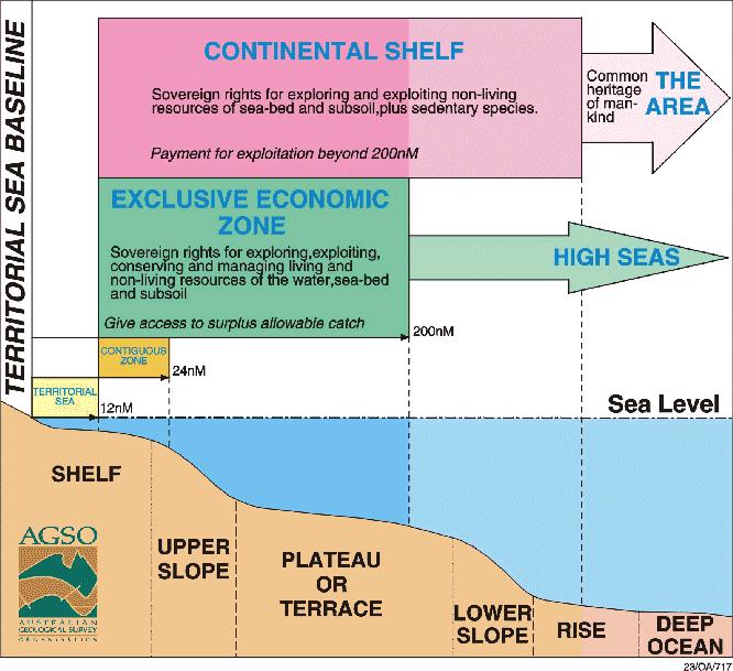
 National Perspectives - Portugal Margarida Almodovar margarida.almodovar@mam.gov.pt from base line to the external limit of the continental shelf behind 200 miles and according to UNCLOS definitions Economic
Marine Spatial Planning (MSP): A practical approach to ecosystembased
: A practical approach to ecosystembased") Marine Spatial Planning (MSP): A practical approach to ecosystembased management Erik Olsen, Institute of Marine Research, Norway Fanny Douvere, International Oceanographic Commission Overview Why we need
Marine Spatial Planning (MSP): A practical approach to ecosystembased management Erik Olsen, Institute of Marine Research, Norway Fanny Douvere, International Oceanographic Commission Overview Why we need
Designing Networks of Marine Protected Areas in DFO s Three Atlantic Bioregions
 Designing Networks of Marine Protected Areas in DFO s Three Atlantic Bioregions Presentation for Indigenous Protected Areas Workshop Max Westhead, DFO and Adrian Gerhartz-Abraham, Dalhousie March 29, 2017
Outline National legislative & policy context Regional history with ESSIM ESSIM Evaluation Phase Government Integration via RCCOM Regional ICOM Framew
 What MSP Implementation could change in the Maritimes Region Tim Hall, Regional Manager Oceans and Coastal Management Division Ecosystem Management Branch Fisheries and Oceans Canada Maritimes Region BIO
NOAA Nautical Charts and Coastal and Marine Spatial Planning. Meredith Westington Chief Geographer NOAA/NOS/Office of Coast Survey
 NOAA Nautical Charts and Coastal and Marine Spatial Planning Meredith Westington Chief Geographer NOAA/NOS/Office of Coast Survey Ocean Policy Task Force What is CMSP? A comprehensive, adaptive, integrated,
Maritime Spatial Planning Framework Directive Supported by INSPIRE
 Maritime Spatial Planning Framework Directive Supported by INSPIRE Andrej Abramić, Vanda Nunes de Lima, Paul Smits, Emanuele Bigagli, Chris Schubert European Commission Joint Research Centre Institute
Opening their Shells Getting commercial clammers involved in marine spatial planning
 Opening their Shells Getting commercial clammers involved in marine spatial planning Ed Lewandowski Coastal Communities Development Specialist University of Delaware/Delaware Sea Grant Highlights Background
Country Fiche Lithuania
 Country Fiche Lithuania Updated June 2018 1. General information The Lithuanian maritime space is delimited by the Decree of the Government of the Republic of Lithuania of 6 December, 2004, No. 1597 and
A TOOLKIT FOR MARINE SPATIAL PLANNING Version: 17 July, 2009
 A TOOLKIT FOR MARINE SPATIAL PLANNING Version: 17 July, 2009 NEED FOR MARINE SPATIAL PLANNING The health of marine ecosystems is declining, and use conflicts in the marine environment are increasing, in
Aquaculture Spatial Planning: The case of Greece
 Aquaculture Spatial Planning: The case of Greece Nikos Anagnopoulos Panhellenic Association for Small-Medium sized Aquaculture Enterprises Panhellenic Association for Small-Medium sized Aquaculture Enterprises
1. Baltic SCOPE Towards coherence and cross-border solutions in Baltic Maritime Spatial Plans
 NSHC 32th Conference Explanatory Note Dublin, Ireland Item E.2 MSP 21-23 June 2016 Germany Cross border MSP for the EEZ, a case study from the Baltic Sea The Federal Maritime and Hydrographic Agency of
Marine Spatial Data for Marine Spatial Planning. Ocean Leadership 2010 Public Policy Forum
 Marine Spatial Data for Marine Spatial Planning Ocean Leadership 2010 Public Policy Forum March 10, 2010 Edward Saade President, Fugro EarthData, Inc 1 Marine Spatial Data What is Marine Spatial Data?
Major human activities affecting Norwegian coastal marine ecosystems; present status and challenges
 Major human activities affecting Norwegian coastal marine ecosystems; present status and challenges Erlend Moksness PICES Annual Meeting - Science Board Symposium 26. October 2009, Jeju, Korea FUTURE:
Country Fiche Estonia
 Country Fiche Estonia Updated October 2017 1. General information Size of internal waters (to the baseline) and territorial sea (12-nm zone from the baseline) approximately 25 200 km 2. Exclusive economic
Introduction to IMP: need and added value
 Introduction to IMP: need and added value Christophe Le Visage Consultant Stratégies Mer et Littoral 1 Summary IMP : Why? The case for integration 1 What is IMP? 2 Content, process IMP: Added Value 3 2
CX Debate Topic Analysis
 CX Debate Topic Analysis Larry McCarty lmac916@gmail.com or larry.mc@excite.com Resolved: The United States federal government should substantially increase its nonmilitary exploration and/or development
Country Fiche Estonia
 Country Fiche Estonia Deleted: October Updated May 2018 Deleted: 7 1. General information Size of internal waters (to the baseline) and territorial sea (12-nm zone from the baseline) approximately 25 200
MARINE SPATIAL PLANNING & MARINE CADASTRE: CHALLENGES AND ISSUES
 MARINE SPATIAL PLANNING & MARINE CADASTRE: CHALLENGES AND ISSUES Roger Longhorn Secretary General, GSDI Association rlonghorn@gsdi.org Member, IHO Marine SDI Working Group ral@alum.mit.edu Member, UNESCO
PartiSEApate Conference
 Baltic Maritime Spatial Planning Forum PartiSEApate Conference C r e a t i n g c o m m o n u n d e r s t a n d i n g B a l t i c M a r i t i m e S p a t i a l P l a n n i n g F o r u m B a l t i c M a
WELCOME & INTRODUCTION
 MPA Management Capacity Building Training Module 1: WELCOME & INTRODUCTION Participants Distinguished Guests Welcome Site Overviews of MPAs represented Overview of Training Program What are Today s Objectives?
DRAFT PROGRAM Registration of participants, welcome coffee, exhibition tour
 DRAFT PROGRAM 20 Feb 2018 09.00-10.00 Registration of participants, welcome coffee, exhibition tour 10.00 12.00 ROUND TABLE: INTERNATIONAL COOPERATION IN THE ARCTIC PROJECTS: CHALLENGES AND OPPORTUNITIES
TOWARDS CLIMATE-RESILIENT COASTAL MANAGEMENT: OPPORTUNITIES FOR IMPROVED ICZM IN BELIZE
 TOWARDS CLIMATE-RESILIENT COASTAL MANAGEMENT: OPPORTUNITIES FOR IMPROVED ICZM IN BELIZE CHANTALLE SAMUELS Coastal Zone Management Authority and Institute The Caribbean Community Climate Change Centre VULNERABILITY
Marine Spatial Planning as an important tool for implementing the MSFD
 Marine Spatial Planning as an important tool for implementing the MSFD Risto Kalliola Tallinn, Nov. 16 th 2012 DEPARTMENT OF GEOGRAPHY AND GEOLOGY University of Turku, Finland Ten principles to provide
COUNTRY REPORT: BELGIUM Marine Spatial Planning and the Protection of the Marine Environment in the Belgian Part of the North Sea
 Belgium: Marine Spatial Planning 144 COUNTRY REPORT: BELGIUM Marine Spatial Planning and the Protection of the Marine Environment in the Belgian Part of the North Sea Thary Derudder and Frank Maes Introduction
Maritime Spatial Planning in the Baltic Sea Region
 Maritime Spatial Planning in the Baltic Sea Region Talis Linkaits Head of VASAB Secretariat 20 May 2015 Helsinki A cooperation of ministers of the 11 Baltic Sea Region countries responsible for spatial
NORTH VANCOUVER ISLAND MARINE PLAN: OVERVIEW 2015
 NORTH VANCOUVER ISLAND MARINE PLAN: OVERVIEW 2015 North Vancouver Island Marine Plan Overview Refers to: Marine Planning Partnership Initiative. 2015. North Vancouver Island Marine Plan. Copyright 2015
MODELS AND TOOLS FOR GOVERNANCE OF
 Working Papers Collection No. 1/2015 MODELS AND TOOLS FOR GOVERNANCE OF THE ADRIATIC AND IONIAN SEAS www.unimc.it/maremap NATIONAL POLITICS AND EU POLITICS: THE MARITIME SPATIAL PLANNING AND INTEGRATED
Croatian physical planning system and strategic approach to MSP
 W 1/7 Past two years all over the Europe: case studies 2 Croatian physical planning system and strategic approach to MSP Vesna Marohnić Kuzmanović Head of Department Croatian Institute for Spatial Development
DFO Maritimes Region Update. Gulf of Maine Council - Coastal and Marine Spatial Planning (CMSP) Committee Web-Ex May 16, 2017
 Committee Web-Ex May 16, 2017") DFO Maritimes Region Update Gulf of Maine Council - Coastal and Marine Spatial Planning (CMSP) Committee Web-Ex May 16, 2017 1 National Oceans Priorities Marine Conservation Targets Oceans Protection Plan
DFO Maritimes Region Update Gulf of Maine Council - Coastal and Marine Spatial Planning (CMSP) Committee Web-Ex May 16, 2017 1 National Oceans Priorities Marine Conservation Targets Oceans Protection Plan
Implementation of the Political Declaration on energy cooperation between the North Seas Countries. Support Group 1 on Maritime Spatial Planning
 Implementation of the Political Declaration on energy cooperation between the North Seas Countries Support Group 1 on Maritime Spatial Planning Work Programme 1. Work area as outlined in Annex I to the
Offshore Energy and Maritime Spatial Planning in the German EEZ
 Offshore Energy and Maritime Spatial Planning in the German EEZ Bettina Käppeler, BSH Federal Maritime and Hydrographic Agency On Duty for Shipping and Seas German Exclusive Economic Zone EEZ not part
MARITIME PLANNING IN PORTUGAL
 MARITIME PLANNING IN PORTUGAL Marta Chantal Ribeiro 2 May 2007 In Portugal there is currently no strategic planning system in force for the maritime area as a whole The maritime area under Portuguese jurisdiction
Country reports. Israel did not establish an Exclusive Economic Zone. Consequently, its jurisdiction is restricted to the Israeli territorial waters.
 Country reports I. ISRAEL Disclaimer This document has not been adopted by the European Commission and should therefore not be relied upon as a statement of the European Commission. The purpose of this
Cross-border Maritime Spatial Plan for the Black sea - Romania and Bulgaria project
 Cross-border Maritime Spatial Plan for the Black sea - Romania and Bulgaria project in Romania and Bulgaria Plan Presentation A first step in the management of the marine areas of Romania and Bulgaria
Towards international cooperation in the development of Marine Spatial Plans for the North Pacific: economic, social, and environmental dimensions
 Towards international cooperation in the development of Marine Spatial Plans for the North Pacific: economic, social, and environmental dimensions A.V. Sereda, V.B. Lobanov V.I. Il ichev Pacific Oceanological
Mapping Maine s Working Waterfront: for Our Heritage and Economy
 Mapping Maine s Working Waterfront: for Our Heritage and Economy Abstract Mapping Maine s Working Waterfronts is a collaborative project led by the Island Institute that inventories the state s current
Ocean planning as a tool for blue growth and smart specialization - Frederico Cardigos -
 Luís Quinta Ocean planning as a tool for blue growth and smart specialization - Frederico Cardigos - European Maritime Day, 20 of May Marine and Maritime Innovation in the Outermost Regions: blue growth
Country Fiche Latvia Updated October 2016
 Country Fiche Latvia Updated October 2016 1. General information Marine area under Latvian jurisdiction includes inland sea waters, Territorial sea (12 nautical miles from the baseline) and exclusive economic
Marine Geomorphology as a Determinant for Essential Life Habitat III
 Marine Geomorphology as a Determinant for Essential Life Habitat III marinecoastalgis.net/aag08 10:10 Dawn Wright, Oregon 10:30 Will McClintock, California 10:50 Daniel Sampson, Massachusetts 11:10 Gary
MARINE SPATIAL PLANNING
 MARINE SPATIAL PLANNING Washington Uses Spatial Planning to Honor its Pacific Coast and Offshore Waters Past, Present and Future The Washington State Pacific Coast and offshore waters are diverse in both
MPAs - do we need them?
 MPAs - do we need them? Thomas Peschak We all want healthy oceans We all want healthy oceans Our Natural Heritage conserved for future generations We all want healthy oceans To enjoy our sea and the economic
Heather Schlosser Army Corps of Engineers Coastal Studies Group August 28, 2008
 Got sand? Regional Sediment Management in Orange County Heather Schlosser Army Corps of Engineers Coastal Studies Group August 28, 2008 Regional Sediment Management Regional sediment management recognizes
Aboriginal communities strengthen governance with location-based tools in the 21st century
 Aboriginal communities strengthen governance with location-based tools in the 21st century Today, Aboriginal communities are taking advantage of the geomatics technologies that underpin popular online
EUSAIR on sea topics from Slovenian perspective
 MINISTRY OF FOREIGN AFFAIRS REPUBLIC OF SLOVENIA EUSAIR on sea topics from Slovenian perspective Mag. Andreja Jerina National Coordinator 4 EU MRS: 270 millions of population 19 MS 12 non MS Sea basin
Coastal marine ecosystems and Integrated Coastal Zone Management (ICZM); A way forward?
; A way forward?") Coastal marine ecosystems and Integrated Coastal Zone Management (ICZM); A way forward? Erlend Moksness Topic Session S13: Risk management in coastal zone ecosystems around the North Pacific PICES Annual
Coastal marine ecosystems and Integrated Coastal Zone Management (ICZM); A way forward? Erlend Moksness Topic Session S13: Risk management in coastal zone ecosystems around the North Pacific PICES Annual
Biodiversity and Protected Areas Management Project
 Biodiversity and Protected Areas Management Project Technical Advisor ESA region: Selwyn Willoughby Coordinator ESA region: Christine Mentzel FlexiCadastre EMEA Regional User Conference, Cape Town, South
Introduction: The Gulf of Mexico Alliance. The Gulf GAME project MERMAid and PHINS Results & Conclusions What s next? Examples
 AAG Las Vegas March 25, 2009 Introduction: Ocean governance and Ecosystem-Based Management The Gulf of Mexico Alliance Habitat Identification and Characterization The Gulf GAME project MERMAid and PHINS
BALANCE WP4: Development of a Baltic Sea marine area management framework. - with key inputs from WP1, WP2 & WP3
 BALANCE WP4: Development of a Baltic Sea marine area management framework - with key inputs from WP1, WP2 & WP3 BALANCE Kick-Off meeting, Copenhagen, 31 Aug-1 Sept 2005 Contents of the presentation: 1.
A National Ocean Policy for Malaysia: Rationale and Proposed Components. Mohd Nizam Basiron and Cheryl Rita Kaur Maritime Institute of Malaysia
 A National Ocean Policy for Malaysia: Rationale and Proposed Components Mohd Nizam Basiron and Cheryl Rita Kaur Maritime Institute of Malaysia Outline of Presentation Objectives of Presentation Introduction
Iceland and the Arctic: The Politics of Territoriality. Valur Ingimundaron Professor of Contemporary History, University of Iceland
 Iceland and the Arctic: The Politics of Territoriality Valur Ingimundaron Professor of Contemporary History, University of Iceland Drivers of Icelandic Arctic Policies Geostrategic Position Economic Interests
Seabed knowledge In support of UN SDGs
 Seabed knowledge In support of UN SDGs Evert Flier Fiskerifaglig forum 2. november 2017 Hydrography & small scale fishing Hydrography in Transition Serving the Maritime Community Hydrography in Transition
PACIFIC ISLANDS REGIONAL OCEAN POLICY. A healthy Ocean that sustains the livelihoods and aspirations of Pacific Island communities.
 PACIFIC ISLANDS REGIONAL OCEAN POLICY VISION A healthy Ocean that sustains the livelihoods and aspirations of Pacific Island communities. THIS IS OUR OCEAN 1. The care of the ocean is the responsibility
Underwater Parks: Three Case Studies, and a Primer on Marine Boundary Issues. Robert E. Johnson Leland F. Thormahlen
 Robert E. Johnson Leland F. Thormahlen Underwater Parks: Three Case Studies, and a Primer on Marine Boundary Issues Unlike boundaries on land, most marine boundaries are not marked with monuments or fences.
GALVESTON BAY RSM Moving toward an Integrated, Cooperative, and Holistic Approach to Estuarine Sediments
 GALVESTON BAY RSM Moving toward an Integrated, Cooperative, and Holistic Approach to Estuarine Sediments RAE Conference 2010 Larry A. Wise Moffatt & Nichol RSM is a system-based approach for collaboratively
Maritime Spatial Planning: Transboundary Cooperation in the Celtic Seas Looking Ahead
 Maritime Spatial Planning: Transboundary Cooperation in the Celtic Seas Looking Ahead Looking ahead MSP in the context of the European Maritime and Fisheries Fund (EMFF) and beyond SIMCelt Final Conference
Biogeographic Approach to Coastal Assessments & Spatial Planning
 NOAA s Biogeographic Approach to Coastal Assessments & Spatial Planning Mark E. Monaco Mark.Monaco@noaa.gov Center for Coastal Monitoring and Assessment http://ccma.nos.noaa.gov/about/biogeography Biogeography
Greenland: Balancing the need for development and environmental protection. Arctic Frontiers 2016 Industry and Environment
 Greenland: Balancing the need for development and environmental protection Arctic Frontiers 2016 Industry and Environment Speech by Minister for Finance, Mineral Resources and Foreign Affairs Mr. Vittus
PART I - PROJECT IDENTIFICATION INFORMATION PART II - DOCUMENTATION
 No students reported this period Progress Report Project Update Report Reporting Period: 2/1/2014-1/31/2015 MIT Sea Grant College Program E38-300 292 Main Street, Cambridge, MA 02139 (617) 253-9305 PART
MESMA: An integrated tool box to support an ecosystem based spatial management of marine areas
 MESMA: An integrated tool box to support an ecosystem based spatial management of marine areas Stelzenmüller, V., Stamford, T., Vassilopoulou, V., Kastanevakis, S., Vincx, M, Vanaverbeke, J., Rabaut, M.,
PROMOTING NATURE CONSERVATION AND SUSTAINABLE AGRICULTURAL DEVELOPMENT IN THE RURAL AREAS OF HONG KONG
 1 PROMOTING NATURE CONSERVATION AND SUSTAINABLE AGRICULTURAL DEVELOPMENT IN THE RURAL AREAS OF HONG KONG Director of Agriculture, Fisheries and Conservation Dr. LEUNG Siu-fai A STONE S THROW AWAY FROM
Country Fiche Sweden Updated May 2018
 Country Fiche Sweden Updated May 2018 1. General information 2 the territorial sea (12-nm zone) 70,000 km2 the Exclusive Economic Zone 60,000 km2 the EEZ is limited to the central line between adjacent
Marine Spatial Planning Experience from Mecklenburg-Vorpommern (Germany) By Susan Toben
 By Susan Toben") Marine Spatial Planning Experience from Mecklenburg-Vorpommern (Germany) By Susan Toben Ministry of Transport, Building and Regional Development Mecklenburg Vorpommern PlanCoast Lead Partner Administrative
Marine Spatial Planning Experience from Mecklenburg-Vorpommern (Germany) By Susan Toben Ministry of Transport, Building and Regional Development Mecklenburg Vorpommern PlanCoast Lead Partner Administrative
World Oceans Day 2010 Our oceans: opportunities and challenges
 World Oceans Day 2010 Our oceans: opportunities and challenges Roundtable discussion on the United Nations Convention on the Law of the Sea fifteen years after its entry into force HOW EFFECTIVELY IS UNCLOS
IMA s ROLE IN COASTAL AND OCEAN GOVERNANCE IN TRINIDAD AND TOBAGO
 IMA s ROLE IN COASTAL AND OCEAN GOVERNANCE IN TRINIDAD AND TOBAGO Presented by Rahanna Juman, Deputy Director (Ag.) About the Institute of Marine Affairs Institute of Marine Affairs (IMA) was established,
Management Planning & Implementation of Communication Measures for Terrestrial Natura 2000 Sites in the Maltese Islands Epsilon-Adi Consortium
 Management Planning & Implementation of Communication Measures for Terrestrial Natura 2000 Sites in the Maltese Islands Epsilon-Adi Consortium Briefing Meetings, February 2013 CT3101/2011, MEPA, Malta
 BPC Policy No , IIM7fyilK Office of the District Clerk TRANSITION ZONE POLICY")
Towards coherent maritime spatial planning in the Baltic Sea Region, transnational and project perspective Talis Linkaits Head of VASAB Secretariat
 3 June 2013 Riga PartiSEApate Workshop MSP as Tool for Underwater Cultural Heritage Management in the Baltic Sea Towards coherent maritime spatial planning in the Baltic Sea Region, transnational and project
Zoning for the Seychelles Marine Spatial Planning Intiative: process, types, and tools
 Zoning for the Seychelles Marine Spatial Planning Intiative: process, types, and tools To: MSP Technical Working Group From: MSP Technical Team Date: 4 July 2014 Table of Contents 1. Introduction and context...
BOEM Marine Minerals Program
 BOEM Marine Minerals Program Restoring and Protecting Our Nation s Coasts through Stewardship of OCS Sand Resources SECOORA 2018 Annual Meeting May 22-24 Doug Piatkowski Douglas.piatkowski@boem.gov 703-787-1833
BURGAS CASE STUDY: LAND-SEA INTERACTIONS. Dr. Margarita Stancheva
 BURGAS CASE STUDY: LAND-SEA INTERACTIONS Dr. Margarita Stancheva Name of presentation NEED FOR COHERENCE BETWEEN LAND AND SEA ACTIVITIES Name presenter Burgas is the fourth largest city in Bulgaria and
Using Data and Evidence to Inform Marine Spatial Planning
 Coastwatch Workshop and Launch of 30 years of Coastwatch Data Using Data and Evidence to Inform Marine Spatial Planning Stephen Hull Overview What is MSP? What is MSP trying to achieve? Ireland s MSP process
Marine Spatial Planning in the Baltic Sea Region
 Marine Spatial Planning in the Baltic Sea Region Towards coherence and cross-border solutions in Baltic Maritime Spatial Plans Coordinator & Project manager Dr Ingela Isaksson Swedish Agency for Marine
The IUCN Facilitated Independent Advisory Panel on Remediation and Rehabilitation of Biodiversity and Habitats of Oil Spill Sites in the Niger Delta
 World Conservation Congress, Jeju, Korea, September 2012 The IUCN Facilitated Independent Advisory Panel on Remediation and Rehabilitation of Biodiversity and Habitats of Oil Spill Sites in the Niger Delta
Natura 2000 and spatial planning. Executive summary
 Natura 2000 and spatial planning Executive summary DISCLAIMER The information and views set out in this study are those of the author(s) and do not necessarily reflect the official opinion of the Commission.
Maritime Spatial Planning
 Maritime Spatial Planning The Dutch experience Kopenhagen 28 november 2012 Lodewijk.Abspoel@minienm.nl North Sea 2 Outline History of MSP in the Netherlands Spatial Plan for the Dutch EEZ, principles and
Spatial Planning in Canada s Maritimes Region. Maritimes Region
 Spatial Planning in Canada s Maritimes Region Glen Herbert, Scott Coffen-Smout Smout,, and Tanya Koropatnick Oceans and Coastal Management Division Ecosystem Management Branch Fisheries and Oceans Canada
Measurement of the Urban-Housing Deficit:
 Measurement of the Urban-Housing Deficit: Strategies, tools and sources of information The International Network for Urban and Regional Statistics Standing Committee of the International Association for
Oceans in transition
 Oceans governance Oceans in transition OECD: Ocean industry value-added projected to double by 2030 from ~USD 1.5 to 3.0 trillion However, meeting anticipated demand for ocean space and resources will
7B.4 ASSESSMENT OF THE GROSS U.S. OFFSHORE WIND ENERGY POTENTIAL
 7B.4 ASSESSMENT OF THE GROSS U.S. OFFSHORE WIND ENERGY POTENTIAL Marc Schwartz, Donna Heimiller, Steve Haymes, and Walt Musial National Renewable Energy Laboratory, Golden, Colorado 1. INTRODUCTION Offshore
Findings and recommendations from Central Baltic case
 W 1/1 Recommendations on transboundary planning from Baltic SCOPE Findings and recommendations from Central Baltic case Ingūna Urtāne Director of Spatial Planning Department of the Ministry of Environmental
Observation (EO) & Geomatics in Canada
 & Geomatics in Canada") Innovating to Increase the Impact of Earth Observation (EO) & Geomatics in Canada Natural Resources Canada February 25, 2014 Prashant Shukle, Director General Canada Centre for Mapping and Earth Observation
Innovating to Increase the Impact of Earth Observation (EO) & Geomatics in Canada Natural Resources Canada February 25, 2014 Prashant Shukle, Director General Canada Centre for Mapping and Earth Observation
MARINE STUDIES (MARINE SPATIAL PLANNING & MANAGEMENT) MASTER S DEGREE
 MASTER S DEGREE") MARINE STUDIES (MARINE SPATIAL PLANNING & MANAGEMENT) MASTER S DEGREE Influence, lead and provide decision making support for the management and planning of coastal and marine spaces. PROGRAM DESCRIPTION
MARINE STUDIES (MARINE SPATIAL PLANNING & MANAGEMENT) MASTER S DEGREE Influence, lead and provide decision making support for the management and planning of coastal and marine spaces. PROGRAM DESCRIPTION
SPLAN-Natura Towards an integrated spatial planning approach for Natura th January, 2017 Brussels. Commissioned by DG Environment
 SPLAN-Natura 2000 Towards an integrated spatial planning approach for Natura 2000 Commissioned by DG Environment 17 th January, 2017 Brussels V. Simeonova (Ph.D.) Drivers towards integrating Biodiversity
Policy framework The Netherlands and the Polar Regions, Summary and priorities
 Policy framework The Netherlands and the Polar Regions, 2011-2015 Summary and priorities The policy outlined in this Policy Framework for the Polar Regions (2011-2015) is part of the government s orientation
Overview of Methods. Terrestrial areas that are most important for conservation Conservation
 Overview of Methods The goal of the Western Lake Erie Coastal Conservation Vision project (WLECCV) is to define where we should be working locally to optimally achieve regional conservation impact. The
THE SEVILLE STRATEGY ON BIOSPHERE RESERVES
 THE SEVILLE STRATEGY ON BIOSPHERE RESERVES 1 VISION FOR BIOSPHERE RESERVES IN THE 21 ST CENTURY The international Seville Conference on Biosphere Reserves, organised by UNESCO, adopted a two-pronged approach,
Linking Global and Regional Levels in the Management of Marine Areas Beyond National Jurisdiction
 Linking Global and Regional Levels in the Management of Marine Areas Beyond National Jurisdiction South Atlantic Region Session 4: «Experiences, Priorities and Opportunities in the South Atlantic and Indian
Land Use in the context of sustainable, smart and inclusive growth
 Land Use in the context of sustainable, smart and inclusive growth François Salgé Ministry of sustainable development France facilitator EUROGI vice president AFIGéO board member 1 Introduction e-content+
Geospatial Decision Support Tools for Planning of Marine Protected Areas in California
 Geospatial Decision Support Tools for Planning of Marine Protected Areas in California WILL MCCLINTOCK (UNIVERSITY OF CALIFORNIA SANTA BARBARA), MATT MERRIFIELD (THE NATURE CONSERVANCY), SOPHIE DE BEUKELAER
Economic Valuation of the Montego Bay Marine Park
 Economic Valuation of the Montego Bay Marine Park Methodology Test Cases Presenter: Brian L. Zane What? A means to estimate the value of environmental resources How? Different methodologies exist Total
EASTERN SCOTIAN SHELF INTEGRATED OCEAN MANAGEMENT PLAN
 Government of Canada Gouvernement du Canada EASTERN SCOTIAN SHELF INTEGRATED OCEAN MANAGEMENT PLAN SUMMARY Photo Credits: Bedford Institute of Oceanography Published by: Oceans and Habitat Branch Fisheries