Niue Maritime Boundaries Delimitation Project. Christchurch FIGMM
|
|
|
- Joseph Byrd
- 5 years ago
- Views:
Transcription
1 Niue Maritime Boundaries Delimitation Project Christchurch FIGMM 30 th April 6 th May 2016 Hubert Mana Kalauni Secretary for Justice Department of Justice, Lands and Survey Ministry of Social Services (MOSS)
2 Department of Justice, Lands and Survey House the following Divisions Administration, Registration of Births, Deaths & Marriage & General Elections High Court Land Division & Civil/Criminal Division Survey and Land Management Community Development Social Welfare & Social Dev Services
3 Survey and Land Management The Division is responsible for: All Surveys primarily cadastral/title GIS/LIS Land Title Registration Management of Crown Land and Properties Assisting with the Maritime Boundaries Delimitation project (technical data). Division staff by 2 surveyors, 3 chainmen, 1 GIS technical officer, 4 survey cadets, draughting officer and Land registration officer.
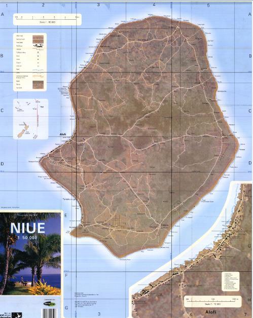
4 Niue geography and location An isolated raised coral atoll consist of two terraces the first is at about metres above MSL 2nd at 70 metres. The centre of the island was once a lagoon and is lower than the top terrace, at about 45 metres above MSL. Approximately 21 km long and 18 km wide, no hills, no running streams or surface water
5 Niue geography and location Niue Total land area is 260 sq km 95% Niuean land & 5% Crown Land not for sale, can lease Population at about (2015)
6
7
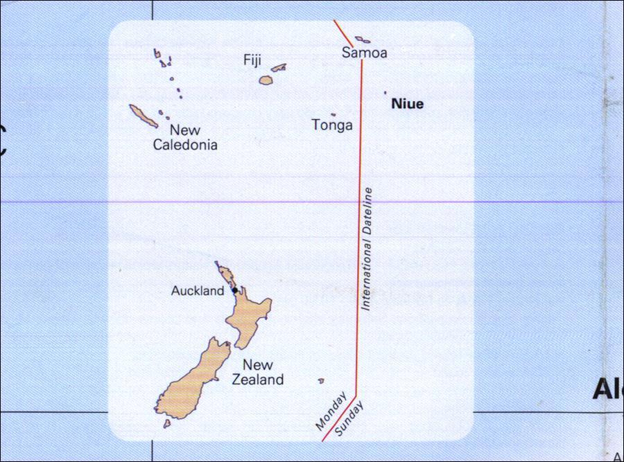
8 Niue Maritime Boundaries Delimitation Overview Niue maritime neighbouring states are Tonga 470 km to the west, American Samoa 550 km to the north, Cooks 900 km to the east and the high seas to the south.
9 Niue Maritime Boundaries Delimitation Overview The total peripheral EEZ distances total 2,100 km (approx) 630 km shared with Tonga 550 km with American Samoa 230 km with the Cooks, and 700 km with the high seas The total EEZ area comprised approximately of 320, 000 sq km
10 Niue EEZ Maritime Boundaries
11 Niue Maritime Boundaries Delimitation. Background and Development. The project for Niue starts in the early 1991 By way of Maritime Boundary workshops in Suva, Apia, Rarotonga, Toronto Canada etc attended by both Legal & Technical officers 1992 FFA commence compiling the first set of baseline data for the Territorial Sea limits. Compiled by Grant Boyes, FFA Coordinator. Facilitated one workshop for local staff.
12 Niue Maritime Boundaries Delimitation Background and Development. In 2005 Niue with the assistance of SOPAC recomputed the baseline data for the Territorial Sea Limits using MarZone. Based on Niue Topographical map, 1991 GPS survey and satellite imageries. Data in terms of WGS84. The baseline data set was officially endorsed by Niue that year. The same data set was also use to compute the limits for Niue CZ and EEZ with the Cooks.

13 Niue Maritime Boundaries

14 Signing of the 2005 Report SOPAC Suva
15 Basepoints

16 Normal baseline

17 Normal Baseline Critical with Tonga
18 Niue Maritime Boundaries Delimitation Negotiation and Signing Negotiation with the Cooks also commenced with the exchange of provisional baseline data in Suva in Delayed due to existing data for Palmerston island not in terms of WGS84. The baseline for Palmerston, Cooks, was updated early 2012.
19 Niue Maritime Boundaries Delimitation Negotiation and Signing Negotiation with the Cooks also commenced with the exchange of provisional baseline data in Suva in Delayed due to existing data for Palmerston island not in terms of WGS84. The baseline for Palmerston, Cooks, was updated early Final Median line computed in 2012 That agreement was concluded and signed in 2012
20 Niue Maritime Boundaries Delimitation Negotiation and Signing Median line with American Samoa. The initial and first contact commenced in the 1991 when American Samoa approach the Niue government through the Ministry of External Relations and Trade to start the negotiation on maritime boundary.
21 Niue Maritime Boundaries Negotiation and Signing Median line with American Samoa. The initial and first contact commenced in the 1991 when American Samoa approach the Niue government through the Ministry of External Relations and Trade to start the negotiation on maritime boundary. The median data was computed by the AS authority using the baseline data from the FFA report. The agreement with American Samoa was signed in 1997.
22 Maritime Boundaries Concluded and Signed The agreement with American Samoa was signed in The agreement with the Cooks was signed in Both Agreements Deposited with the UN.
23 Common Boundary with Tonga The two countries have yet to finalize the median line but currently checking the relevant baseline data. And these are Provisional baseline data exchanged late 2015 A smaller working session is planned in Nadi early June 2016 to progress with the technical and legal negotiations between Tonga and Niue. Assist by Maritime Boundaries Team of the Geoscience Division, Pacific Community (SPC)
24 Tonga Critical Baseline

25 Niue baseline All on the western side
26 Conclusion Niue is looking forward to conclude its boundaries agreement with Tonga by the end of 2016 or Fakaue and thank you.
Pacific Islands Regional Maritime Boundaries Project the latest Update. Malakai Vakautawale (Mr) Maritime Boundaries Adviser
 Maritime Boundaries Adviser") Pacific Islands Regional Maritime Boundaries Project the latest Update Malakai Vakautawale (Mr) Maritime Boundaries Adviser Consortium Partners 2 What we do? Provide technical advice and support on MB
Pacific Islands Regional Maritime Boundaries Project the latest Update Malakai Vakautawale (Mr) Maritime Boundaries Adviser Consortium Partners 2 What we do? Provide technical advice and support on MB
Pacific Islands Regional Maritime Boundaries Project
 Pacific Islands Regional Maritime Boundaries Project 31 st Star Conference, Nadi, FIJI 6-8 June 2016 Jens Kruger Head of Ocean & Coastal Geoscience Sector Andrick Lal Project Officer (Surveying) Emily
Pacific Islands Regional Maritime Boundaries Project
 Pacific Islands Regional Maritime Boundaries Project Presented By Filimoni Yaya (Andrick Lal, Sachindra Singh, Emily Artack) Geoscience Division Pacific Community (SPC Geoscience Division, GSD STAR Sessions,
Pacific Geospatial and Surveying Council (PGSC) Geospatial and GNSS CORS Infrastructure Forum. Kuala Lumpur October
 Geospatial and GNSS CORS Infrastructure Forum. Kuala Lumpur October") Pacific Geospatial and Surveying Council (PGSC) Geospatial and GNSS CORS Infrastructure Forum. Kuala Lumpur 16-17 October Beginning and Progress Members PGSC Charter PGSC Strategy 2017-2027 Meetings Geodetic
Pacific Geospatial and Surveying Council (PGSC) Geospatial and GNSS CORS Infrastructure Forum. Kuala Lumpur 16-17 October Beginning and Progress Members PGSC Charter PGSC Strategy 2017-2027 Meetings Geodetic
Briefing document of the status of maritime boundaries in Pacific island countries
 Secretariat of the Pacific Community Seventh Heads of Fisheries Meeting (28 Feb. 4 March 2011, Noumea, New Caledonia) Working Paper 5 Original: English Briefing document of the status of maritime boundaries
Status & Challengers of Cook Islands GEO DRM. Cook Islands GEO S/GIS History
 Status & Challengers of Cook Islands GEO DRM By Patrick A. ARIOKA Planning & Advisory Officer EMERGENCY MANAGEMENT COOK ISLANDS Cook Islands GEO S/GIS History 1990 NZODA/MFAT trained by Landcare Research
Kam Na Bane Ni Mauri
 International Workshop on Legal and Policy Frameworks for Geospatial Information Management: Licensing of Geospatial Information Nuku'alofa, Kingdom of Tonga 10 13 April 2018 Kam Na Bane Ni Mauri Kiribati
Deep Sea Minerals in the Pacific Islands Region: Occurrence, Potential and Case Studies`
 Deep Sea Minerals in the Pacific Islands Region: Occurrence, Potential and Case Studies` 1st DSM Project Regional Workshop 6th 8th June 2011 Tanoa International Hotel Nadi, Fiji Akuila Tawake SPC/SOPAC
Positioning in the Pacific Islands
 Positioning in the Pacific Islands Andrick Lal United Nations/Nepal Workshop on the Applications of Global Navigation Satellite Systems Kathmandu - Nepal 15 th December 2016 Presentation Outline Introduction
Faatasi Malologa (PGSC Chair) Director Department of Lands & Survey, Tuvalu
 Director Department of Lands & Survey, Tuvalu") Seventh Session of the United Nations Committee of Experts on Global Geospatial Information Management (UN-GGIM) - 31 July -4 August 2017 Faatasi Malologa (PGSC Chair) Director Department of Lands & Survey,
Seventh Session of the United Nations Committee of Experts on Global Geospatial Information Management (UN-GGIM) - 31 July -4 August 2017 Faatasi Malologa (PGSC Chair) Director Department of Lands & Survey,
THE CURRENT STATUS OF MAPPING IN THE WORLD - SPOTLIGHT ON PACIFIC ISLANDS
 THE CURRENT STATUS OF MAPPING IN THE WORLD - SPOTLIGHT ON PACIFIC ISLANDS John C. Trinder School of Civil and Environmental Engineering, UNSW SYDNEY NSW 2052, Australia (j.trinder@unsw.edu.au) Commission
Report of the Regional Committee of UN-GGIM for Asia and the Pacific (UN-GGIM-AP)
") Report of the Regional Committee of UN-GGIM for Asia and the Pacific (UN-GGIM-AP) At the Eighth Session of UN-GGIM UN Headquarters, New York, 1 3 August 2018 About UN-GGIM-AP One of the five regional committees
Report of the Regional Committee of UN-GGIM for Asia and the Pacific (UN-GGIM-AP) At the Eighth Session of UN-GGIM UN Headquarters, New York, 1 3 August 2018 About UN-GGIM-AP One of the five regional committees
FIG Asia Pacific Capacity Development Network
 FIG Asia Pacific Capacity Development Network Report to the 41th General Assembly FIG Congress 2018, Istanbul - Turkey Rob Sarib Chair FIG Asia Pacific Capacity Development Network (AP CDN) Story of the
Remote sensing and GIS for multi-hazard risk assessments in the coastal zone: recent applications and challenges in the Pacific Jens Kruger
 Remote sensing and GIS for multi-hazard risk assessments in the coastal zone: recent applications and challenges in the Pacific Jens Kruger Geoscience Division Pacific Community (SPC) The First Pacific
A Pacific Regional Economics of Climate Change Study: Assessing adaptation needs in Small Island Developing States
 Regional Economics of Climate Change: Practitioners Workshop 4-5 March 2009 Washington, DC, USA A Pacific Regional Economics of Climate Change Study: Assessing adaptation needs in Small Island Developing
UNITED NATIONS E/CONF.96/CRP. 5
 UNITED NATIONS E/CONF.96/CRP. 5 ECONOMIC AND SOCIAL COUNCIL Eighth United Nations Regional Cartographic Conference for the Americas New York, 27 June -1 July 2005 Item 5 of the provisional agenda* COUNTRY
1982 United Nations Convention on the Law of the Sea
 1982 United Nations Convention on the Law of the Sea Article 16, 47, 75, 76 and 84 Article 16, 47, 75, 76 and 84 require Coastal States to deposit geographic information pertaining to their maritime limits
MALDIVES. Regional Expert Workshop On Land Accounting For SDG Monitoring & Reporting (25-27 th Sept 2017) - Fathimath Shanna, Aishath Aniya -
 - Fathimath Shanna, Aishath Aniya -") MALDIVES Regional Expert Workshop On Land Accounting For SDG Monitoring & Reporting (25-27 th Sept 2017) - Fathimath Shanna, Aishath Aniya - ABOUT MALDIVES Approximately 860 km long and 120 km wide Consists
MALDIVES Regional Expert Workshop On Land Accounting For SDG Monitoring & Reporting (25-27 th Sept 2017) - Fathimath Shanna, Aishath Aniya - ABOUT MALDIVES Approximately 860 km long and 120 km wide Consists
Maritime Boundary Negotiations National Considerations Dr. Robert W. Smith
 Maritime Boundary Negotiations National Considerations Dr. Robert W. Smith ABLOS: ADDRESSING DIFFICULT ISSUES IN UNCLOS 28 OCTOBER 2003 Practical Steps in the Negotiating Process 1. The Delimitation Process
Economic and Social Council
 United Nations Economic and Social Council Distr.: General 18 July 2016 Original: English Committee of Experts on Global Geospatial Information Management Sixth session New York, 3-5 August 2016 Item 2
The Efforts of Building GIS Infrastructure in a Newly Independent State: The case of Timor Leste *
 UNITED NATIONS E/CONF.100/IP.12 ECONOMIC AND SOCIAL COUNCIL Eighteenth United Nations Regional Cartographic Conference for Asia and the Pacific Bangkok, 26-29 October 2009 Item 7(b) of the provisional
EXECUTIVE SUMMARY A SUBMISSION OF DATA AND INFORMATION ON THE OUTER LIMITS OF THE CONTINENTAL SHELF OF THE REPUBLIC OF NIGERIA PURSUANT TO
 EXECUTIVE SUMMARY A SUBMISSION OF DATA AND INFORMATION ON THE OUTER LIMITS OF THE CONTINENTAL SHELF OF THE REPUBLIC OF NIGERIA PURSUANT TO PART VI OF AND ANNEX II TO THE UNITED NATIONS CONVENTION ON THE
Indonesia s Internal Maritime Boundaries
 University of Wollongong-Lecture in Boundaries, November 2005 Indonesia s Internal Maritime Boundaries 1 Lecture Outline Indonesia's internal maritime boundaries Law no. 22/1999 --> Law no. 32/2004 Technical
Underwater Parks: Three Case Studies, and a Primer on Marine Boundary Issues. Robert E. Johnson Leland F. Thormahlen
 Robert E. Johnson Leland F. Thormahlen Underwater Parks: Three Case Studies, and a Primer on Marine Boundary Issues Unlike boundaries on land, most marine boundaries are not marked with monuments or fences.
Country Report On Sdi Activities In Singapore ( )
") UNITED NATIONS E/CONF.102/IP.4 ECONOMIC AND SOCIAL COUNCIL Nineteenth United Nations Regional Cartographic Conference for Asia and the Pacific Bangkok, 29 October 1 November 2012 Item 6(b) of the provisional
UNITED NATIONS E/CONF.102/IP.4 ECONOMIC AND SOCIAL COUNCIL Nineteenth United Nations Regional Cartographic Conference for Asia and the Pacific Bangkok, 29 October 1 November 2012 Item 6(b) of the provisional
Applied Geoscience and Technology Division SOPAC. Joy Papao, Risk Information Systems Officer
 Joy Papao, Risk Information Systems Officer Secretariat of the Pacific Community SPC 22 Pacific Island States Head office in Noumea, New Caledonia 2 Regional offices (Pohnpei and Honiara) 600 staff 9 Technical
Development of the Kingdom of Tonga Cyclone Emergency Recovery and Management System using Geospatial Tools
 Development of the Kingdom of Tonga Cyclone Emergency Recovery and Management System using Geospatial Tools Case Studies from Small Island States FIG Commissions 3, 7 and 8 Malcolm Archbold General Manager
Report of the United Kingdom Division
 UNITED NATIONS GROUP OF EXPERTS WORKING PAPER ON GEOGRAPHICAL NAMES NO. 41/4 Twenty-ninth session Bangkok, Thailand, 25 29 April 2016 Item 4 of the Provisional Agenda Report of the Divisions Report of
Some Thoughts on Maritime Delimitation among the Northeast Asian States
 Some Thoughts on Maritime Delimitation among the Northeast Asian States Seokwoo LEE Assistant Professor College of Law INHA University Korea leeseokwoo@inha.ac.kr 1 I. Common geographical features II.
Ocean governance in Samoa: A case study of ocean governance in the South Pacific
 Ocean governance in Samoa: A case study of ocean governance in the South Pacific Anama Solofa UN-Nippon Nippon Foundation of Japan Fellowship 2009-2010 2010 Outline: I. Ocean governance in the South Pacific
Country Fiche Latvia Updated October 2016
 Country Fiche Latvia Updated October 2016 1. General information Marine area under Latvian jurisdiction includes inland sea waters, Territorial sea (12 nautical miles from the baseline) and exclusive economic
JOINT SUBMISSION TO THE COMMISSION ON THE LIMITS OF THE CONTINENTAL SHELF BY TUVALU, THE REPUBLIC OF FRANCE AND NEW ZEALAND (TOKELAU)
") JOINT SUBMISSION TO THE COMMISSION ON THE LIMITS OF THE CONTINENTAL SHELF BY TUVALU, THE REPUBLIC OF FRANCE AND NEW ZEALAND (TOKELAU) TABLE OF CONTENTS i. PREFACE... iii ii. LIST OF FIGURES... iv iii.
JOINT SUBMISSION TO THE COMMISSION ON THE LIMITS OF THE CONTINENTAL SHELF BY TUVALU, THE REPUBLIC OF FRANCE AND NEW ZEALAND (TOKELAU) TABLE OF CONTENTS i. PREFACE... iii ii. LIST OF FIGURES... iv iii.
Cooperation is the key, FIG can facilitate
 Cooperation is the key, FIG can facilitate Mikael Lilje Vice President 2017-2020 Head, Geodetic infrastructure, Swedish mapping, cadastral and land registration authority Presented at the GIS/RS Conference
MAPS AND COORDINATES...
 Table of Contents 1 INTRODUCTION... 2 2 MAPS AND COORDINATES... 3 3 ADVISORY ASSISTANCE FROM COMMISSION MEMBERS... 3 4 PROVISIONS OF ARTICLE 76 INVOKED... 3 5 OUTSTANDING MARITIME DELIMITATIONS... 4 6
Integration Activities in Indonesia: The Integration of Land and Marine Spatial Data Sets as Part of Indonesian SDI Development
 Integration Activities in Indonesia: The Integration of Land and Marine Spatial Data Sets as Part of Indonesian SDI Development M. Arief Syafi i National Coordination Agency for Surveys and Mapping (B
This Book Belonged to
 THE AMERICAN UNIVERSITY Washington College of Law Library This Book Belonged to The Private Collection of Judge Richard R, Baxter I THE AMERICAN UNIVERSITY Washington College of Law Law Library W-, D.C.
Geodetic & Geospatial Infrastructure/Systems
 Geodetic & Geospatial Infrastructure/Systems 1. Geodetic System: Borneo Triangulation 1968 (BT68) 2. Geospatial System: Land and Survey Information System (LASIS) LAND AND SURVEY DEPARTMENT SARAWAK An
EXECUTIVE SUMMARY A PARTIAL SUBMISSION OF DATA AND INFORMATION ON THE OUTER LIMITS OF THE CONTINENTAL SHELF OF THE KINGDOM OF TONGA PURSUANT TO
 EXECUTIVE SUMMARY A PARTIAL SUBMISSION OF DATA AND INFORMATION ON THE OUTER LIMITS OF THE CONTINENTAL SHELF OF THE KINGDOM OF TONGA PURSUANT TO PART VI OF AND ANNEX II TO THE UNITED NATIONS CONVENTION
Country Report on SDI Activities in Singapore *
 UNITED NATIONS E/CONF.100/CRP.9 ECONOMIC AND SOCIAL COUNCIL Eighteenth United Nations Regional Cartographic Conference for Asia and the Pacific Bangkok, 26-29 October 2009 Item 7(a) of the provisional
Brazil Paper for the. Second Preparatory Meeting of the Proposed United Nations Committee of Experts on Global Geographic Information Management
 Brazil Paper for the Second Preparatory Meeting of the Proposed United Nations Committee of Experts on Global Geographic Information Management on Data Integration Introduction The quick development of
ECONOMIC AND SOCIAL COUNCIL 13 July 2007
 UNITED NATIONS E/CONF.98/CRP.34 ECONOMIC AND SOCIAL COUNCIL 13 July 2007 Ninth United Nations Conference on the Standardization of Geographical Names New York, 21-30 August 2007 Item 17(b) of the provisional
Maritime Boundary Delimitation: Recent ICJ Jurisprudence Nicaragua v Colombia; Peru v Chile
 Maritime Boundary Delimitation: Recent ICJ Jurisprudence Nicaragua v Colombia; Peru v Chile May 28, 2014 Prof. Seokwoo LEE Inha University Law School leeseokwoo@inha.ac.kr 1 Recent Developments The Black
CONTINENTAL SHELF SUBMISSION OF ANGOLA - EXECUTIVE SUMMARY -
 CONTINENTAL SHELF SUBMISSION OF ANGOLA - EXECUTIVE SUMMARY - INDEX List of Figures 2 List of Tables 3 1 Introduction 5 2 Provisions of Article 76 7 3 Angolan Institutions responsible for the Submission
D.N.D. Hettiarachchi (Hetti) Survey Department, Sri Lanka.
 Survey Department, Sri Lanka.") ADMINISTRATION OF GEOGRAPHICAL NAMES IN SRI LANKA D.N.D. Hettiarachchi (Hetti) Survey Department, Sri Lanka. hettiarachchidnd@gmail.com Country: Sri Lanka What is the official language(s)? Sinhala and
ADMINISTRATION OF GEOGRAPHICAL NAMES IN SRI LANKA D.N.D. Hettiarachchi (Hetti) Survey Department, Sri Lanka. hettiarachchidnd@gmail.com Country: Sri Lanka What is the official language(s)? Sinhala and
Development of the Kingdom of Tonga Cyclone Emergency Recovery and Management System using Geospatial Tools
 Development of the Kingdom of Tonga Cyclone Emergency Recovery and Management System using Geospatial Tools Malcolm ARCHBOLD, New Zealand and Sione Nailasikau (Naila) HALATUITUIA, Tonga. Key words: Tonga,
The efforts building GIS infrastructure in a newly independent state The case of Timor Leste
 The efforts building GIS infrastructure in a newly independent state The case of Timor Leste Paulino da Cruz Ministry of Justice National Directorate of Land and Property and Cadastral Services (DNTPSC)
Country Report.
 Country Report www.statsfiji.gov.fj Communication and Advocacy for Agriculture and Rural Statistics 27 June -01 July, 2016, Daejeon, Republic of Korea Outline Brief Introduction National Statistical System
IAEG SDGs WG GI, , Mexico City
 IAEG SDGs WG GI, 12-14.12.2016, Mexico City UN-GGIM:Europe s perspective and activities to support better integration of geospatial information and statistics and the UN SDG monitoring Pier-Giorgio Zaccheddu,
ECONOMIC AND SOCIAL COUNCIL 10 July 2007
 UNITED NATIONS E/CONF.98/CRP.22 ECONOMIC AND SOCIAL COUNCIL 10 July 2007 Ninth United Nations Conference on the Standardization of Geographical Names New York, 21-30 August 2007 Item 9(a) of the provisional
REPORT TO THE PLANNING, TRANSPORTATION AND PROTECTIVE SERVICES COMMITTEE MEETING OF JUNE 26, 2013
 PPS/PS 2013-07 REPORT TO THE PLANNING, TRANSPORTATION AND PROTECTIVE SERVICES COMMITTEE MEETING OF JUNE 26, 2013 SUBJECT UPDATES TO THE CAPITAL REGIONAL DISTRICT MODELLING OF POTENTIAL TSUNAMI INUNDATION
Second Administrative Level Boundaries (SALB) initiative & geographic names in cartography. Geospatial Information Section
 initiative & geographic names in cartography. Geospatial Information Section") Second Administrative Level Boundaries (SALB) initiative & geographic names in cartography Geospatial Information Section Introduction Goals Global agenda How does SALB work? Latest News on geographic
Second Administrative Level Boundaries (SALB) initiative & geographic names in cartography Geospatial Information Section Introduction Goals Global agenda How does SALB work? Latest News on geographic
OUTLINE OF PRESENTATION
 XXIV FIG International Congress 2010 SIDS Workshop, Small Island Developing States and The Millennium Development Goals 14 th and 15 th April 2010, Sydney, Australia. Case Study of the Papua New Guinea
STUDY ON URGENT ESTABLISHMENT OF TOPOGRAPHIC MAPPING IN EAST TIMOR CREATION OF TOPOGRAPHIC INFORMATION FOR ESTABLISHMENT OF CADASTRE IN EAST TIMOR
 STUDY ON URGENT ESTABLISHMENT OF TOPOGRAPHIC MAPPING IN EAST TIMOR CREATION OF TOPOGRAPHIC INFORMATION FOR ESTABLISHMENT OF CADASTRE IN EAST TIMOR Toru WATANABE, Japan The first digital topographic mapping
ANNEX 23 RESOLUTION MSC.231(82) ADOPTION OF AMENDMENTS TO THE EXISTING MANDATORY SHIP REPORTING SYSTEM IN THE GULF OF FINLAND
 ADOPTION OF AMENDMENTS TO THE EXISTING MANDATORY SHIP REPORTING SYSTEM IN THE GULF OF FINLAND") RESOLUTION MSC.231(82) (adopted on 5 December 2006) ADOPTION OF AMENDMENTS TO THE EXISTING MANDATORY SHIP REPORTING SYSTEM IN THE GULF OF FINLAND THE MARITIME SAFETY COMMITTEE, RECALLING Article 28(b)
RESOLUTION MSC.231(82) (adopted on 5 December 2006) ADOPTION OF AMENDMENTS TO THE EXISTING MANDATORY SHIP REPORTING SYSTEM IN THE GULF OF FINLAND THE MARITIME SAFETY COMMITTEE, RECALLING Article 28(b)
Ocean Governance and the Japanese Basic Act on Ocean Policy
 Ocean Governance and the Japanese Basic Act on Ocean Policy Hiroshi Terashima Executive Director Ocean Policy Research Foundation 14 April 2009 The United Nations Nippon Foundation Fellowship Programme
The Integration of Land and Marine Spatial Data Set As Part of Indonesian Spatial Data Infrastructure Development
 UNITED NATIONS E/CONF.97/6/IP. 46 ECONOMIC AND SOCIAL COUNCIL Seventeenth United Nations Regional Cartographic Conference for Asia and the Pacific Bangkok, 18-22 September 2006 Item 7 of the provisional
Valuing and conserving the benefits of marine biodiversity in the South Pacific
 Valuing and conserving the benefits of marine biodiversity in the South Pacific Five years of support for integrated ocean governance in Pacific Island Countries 2 We are the sea, we are the ocean we must
Economic and Social Council
 United Nations Economic and Social Council Distr.: General 23 May 2012 Original: English E/CONF.101/100 Tenth United Nations Conference on the Standardization of Geographical Names New York, 31 July 9
Current and future climate of the Cook Islands. Pacific-Australia Climate Change Science and Adaptation Planning Program
 Pacific-Australia Climate Change Science and Adaptation Planning Program Penrhyn Pukapuka Nassau Suwarrow Rakahanga Manihiki N o r t h e r n C o o k I s l a nds S o u t h e Palmerston r n C o o k I s l
Presented to Sub-regional workshop on integration of administrative data, big data and geospatial information for the compilation of SDG indicators
 Presented to Sub-regional workshop on integration of administrative data, big data and geospatial information for the compilation of SDG indicators 23-25 April,2018 Addis Ababa, Ethiopia By: Deogratius
Nineteenth SPREP Meeting
 Page 1 SECRETARIAT OF THE PACIFIC REGIONAL ENVIRONMENT PROGRAMME Nineteenth SPREP Meeting Pohnpei, Federated States of Micronesia 04 12 September 2008 Agenda Item 9.2.5: Regional Meteorological Services
Understanding China Census Data with GIS By Shuming Bao and Susan Haynie China Data Center, University of Michigan
 Understanding China Census Data with GIS By Shuming Bao and Susan Haynie China Data Center, University of Michigan The Census data for China provides comprehensive demographic and business information
Delimitation of the continental shelf beyond 200 M in the light of recent case law
 Delimitation of the continental shelf beyond 200 M in the light of recent case law K.G. Jebsen Centre for the Law of the Sea Centre Days Workshop 23 September 2014 Session 2 Alex G. Oude Elferink K.G.
Monitoring Surveys PSLMP COSPPac
 Monitoring Surveys PSLMP COSPPac Andrick Lal, Marika Kalouniviti & Veenil Rattan Science, Technology And Resources (STAR) Conference 26 th 29 th June 2017 Nadi FIJI Geodetic Survey Unit (SPC) Andrick Lal,
Overview of Technical Advisory Missions
 Expert Group Meeting (EGM) on Georeferenced Information Systems for Disaster Risk Management (Geo-DRM) and sustaining the Community of Practice (COP) 23-25 April 2014 Bangkok Overview of Technical Advisory
* E/C ONF * "Prepared by the Directorate of Geodesy and Cartography, Ministry of Regional Development and Public Works.
 3 September 2002 Original: Engiish Eighth United Nations Conference on the Standardization of Geographical Names Berlín, 27 August-5 September 2002 Item 4 of the provisional agenda" REPORTS BY GOVERNMENTS
Reference Frame in Practice Workshop 1A
 Reference Frame in Practice Workshop 1A Status of Geodetic Infrastructure in the Pacific Region Case Studies Rob Sarib - FIG Commission 5 Vice Chair of Administration Welcome! Bula! Who are the International
Sharing the Resources of the South China Sea
 Sharing the Resources of the South China Sea MARK J. VALENCIA Senior Fellow, East-West Center, Honolulu, Hawaii, U.SA. JON M. VAN DYKE Professor oflaw, Wm. S. Richardson School oflaw, University of Hawaii,
Tsunami Response and the Enhance PTWC Alerts
 Tsunami Response and the Enhance PTWC Alerts Ken Gledhill GeoNet Project Director Chair, Intergovernmental Coordination Group, Pacific Tsunami Warning and Mitigation System (PTWS) Overview 1. Procedures
Implementation Status & Results Indonesia Improving Governance for Sustainable Indigenous Community Livelihoods in Forested Areas (P130632)
") Public Disclosure Authorized Public Disclosure Authorized The World Bank Implementation Status & Results Indonesia Improving Governance for Sustainable Indigenous Community Livelihoods in Forested Areas
Public Disclosure Authorized Public Disclosure Authorized The World Bank Implementation Status & Results Indonesia Improving Governance for Sustainable Indigenous Community Livelihoods in Forested Areas
Nusipepa Lepale Samoa
 Data Collection and modelling for adaptation Nusipepa Lepale Samoa Presentation Outline Background info Geography Climate of Samoa Impacts of Climate Change (CC) in Samoa CC Adaptation in Samoa Data Observation
Towards Reliable Spatial Database of Informal Areas in Greater Cairo Region
 KEYWORDS informal areas, unreliable spatial data, spatial data collecting, capacity building SUMMARY The uncontrolled and rapid increase of Egypt s cities is a major problem of the country. More than the
Pacific Islands Climate Outlook Forum (PICOF) Status Report (Survey) Prepared by: Secretariat of the Pacific Regional Environment Programme (SPREP)
 Status Report (Survey) Prepared by: Secretariat of the Pacific Regional Environment Programme (SPREP)") Pacific Islands Climate Outlook Forum (PICOF) Status Report (Survey) Prepared by: Secretariat of the Pacific Regional Environment Programme (SPREP) Annotated Outline Specific Climate features of concerned
Pacific Islands Climate Outlook Forum (PICOF) Status Report (Survey) Prepared by: Secretariat of the Pacific Regional Environment Programme (SPREP) Annotated Outline Specific Climate features of concerned
Inventory of United Nations Resolutions on Cartography Coordination, Geographic Information and SDI 1
 Inventory of United Nations Resolutions on Cartography Coordination, Geographic Information and SDI I. Resolutions on Cartography Coordination and Establishment of United Nations Regional Cartographic
Positioning the Pacific: NOAA s Geospatial Activities. Juliana Blackwell, Director NOAA s National Geodetic Survey March 6, 2012
 Positioning the Pacific: NOAA s Geospatial Activities Juliana Blackwell, Director NOAA s National Geodetic Survey March 6, 2012 A Common Problem of the Early 19 th Century 1807 President Thomas Jefferson
INSPIRATION results and benefits for the Agency for Real Estate Cadastre
 JOINT RESEARCH CENTER - E&I WORKSHOP INSPIRATION results and benefits for the Agency for Real Estate Cadastre Sonja Dimova, state advisor AGENCY FOR REAL ESTATE CADASTRE REPUBLIC OF MACEDONIA Wednesday,
Executive Summary and Recommendations
 ANNEX I: EXECUTIVE SUMMARY AND RECOMMENDATIONS OF THE 12RMSD TWELFTH REGIONAL MEETING OF THE METEOROLOGICAL SERVICE DIRECTORS 30 -JUNE to 6 -JULY 2007 Rarotonga, Cook Islands Executive Summary and Recommendations
Use of administrative registers for strengthening the geostatistical framework of the Census of Agriculture in Mexico
 Use of administrative registers for strengthening the geostatistical framework of the Census of Agriculture in Mexico Susana Pérez INEGI, Dirección de Censos y Encuestas Agropecuarias. Avenida José María
Clive Schofield * and David Freestone **
 Holding Back the Waves: Options to Secure Maritime Jurisdictional Claims in the Face of Sea Level Rise Clive Schofield * and David Freestone ** *Australian National Centre for Ocean Resources and Security
Current Status of the Standardization of Geographical Names in Cambodia
 1 Current Status of the Standardization of Geographical Names in Cambodia His Excellency Ith Sotha, Under Secretary of States, MLMUPC Mr Chharom Chin, Deputy Director, Geography Department, MLMUPC Mr Narith
GIS, Charts and UNCLOS Can they live together?
 GIS, Charts and UNCLOS Can they live together? Bill Hirst 1 and David Robertson 2 Address 1 Geoscience Australia GPO Box 378 Canberra, ACT 2601 Phone: 02 6249 9741 Fax: 02 6249 9939 Email: Bill.Hirst@ga.gov.au
THIRD MEETING OF THE PACIFIC METEOROLOGICAL COUNCIL. Theme: "Sustainable Weather and Climate Services for a Resilient Pacific "
 PMC-3/InformationPaper-1-Provisional Agenda THIRD MEETING OF THE PACIFIC METEOROLOGICAL COUNCIL Theme: "Sustainable Weather and Climate Services for a Resilient Pacific " 20-23 July 2015 Fa'onelua Convention
Alleghany County Schools Curriculum Guide GRADE/COURSE: World Geography
 GRADE/COURSE: World 2013-14 GRADING PERIOD: 1 st Six Weeks Time Frame Unit/SOLs SOL # Strand Resource Assessment 8 days* The student will use maps, globes, satellite images, photographs, or diagrams to
Chapter 7 Projections Based on Downscaling
 Damage caused by Tropical Cyclone Pat, Cook Islands, February 2010. Photo: National Environment Service, Government of the Cook Islands Chapter 7 Projections Based on Downscaling 181 Summary Downscaled
INTERNATIONAL BOUNDARY FIXING AND THE ROLES OF INDONESIAN SURVEYORS
 INTERNATIONAL BOUNDARY FIXING AND THE ROLES OF INDONESIAN SURVEYORS by: Dr. Sobar Sutisna Sora Lokita Sydney, Australia, 11-16 April 2010 Badan Koordinasi Survei dan Pemetaan Nasional ( B A K O S U R T
Economic and Social Council
 United Nations Economic and Social Council Distr.: General 15 May 2012 Original: English E/CONF.101/4 Tenth United Nations Conference on the Standardization of Geographical Names New York, 31 July 9 August
Journey of supporting CSNs to establish Geo-DRM
 Regional Workshop on Geo-referenced Information Systems for Disaster Risk Management (Geo-DRM) 26-27 June 2014 Bangkok, Thailand Journey of supporting CSNs to establish Geo-DRM Keran Wang Chief, Space
Assisting Countries in the Collection and Analysis of National Statistics
 Assisting Countries in the Collection and Analysis of National Statistics Peter O. Way, Ph.D., Chief International Programs Center U.S. Census Bureau Censuses in the 21 st Century: Improving Data Utilization
Country Fiche Latvia.
 Country Fiche Latvia 1. General information Marine waters under Latvian jurisdiction include inland sea waters, territorial sea (12 nautical miles from the baseline) and exclusive economic zone (EEZ) waters.
Exposure Database of the Pacific Islands. ADB TA 6496-REG: Regional Partnerships for Climate Change Adaptation and Disaster Preparedness
 Exposure Database of the Pacific Islands ADB TA 6496-REG: Regional Partnerships for Climate Change Adaptation and Disaster Preparedness Update GFDRR Meeting 16 19 May 2010 Phil Glassey 1, David Heron 1,
Working Group 1. Geodetic Reference Frame. Activity Report. for. The UN-GGIM-AP Plenary Meeting
 Regional Committee of United Nations Global Geospatial Information Management for Asia and the Pacific (UN-GGIM-AP) Established by a United Nations Resolution Working Group 1 Geodetic Reference Frame Activity
Economic and Social Council
 United Nations Economic and Social Council 28 December 2000 Original: English E/CN.3/2001/2 Statistical Commission Thirty-second session 6-9 March 2001 Item 3 (a) of the provisional agenda * Demographic
THE GEOGRAPHY OF A MARITIME BOUNDARY DELIMITATION. By Adam J.Kerr
 THE GEOGRAPHY OF A MARITIME BOUNDARY DELIMITATION By Adam J.Kerr Abstract. A Judgement of the International Court of Justice, dated 8 October 2007, resolved the Case Concerning Territorial and Maritime
Administration of Mineral Rights
 Administration of Mineral Rights Deborah Archibald Industry, Tourism and Investment, GNWT Malcolm Robb Aboriginal Affairs and Northern Development Canada Business Today How applications are being treated
NUKU ALOFA MINISTERIAL DECLARATION For SUSTAINABLE WEATHER AND CLIMATE SERVICES FOR A RESILIENT PACIFIC. 24th July 2015, Nuku alofa, Tonga
 NUKU ALOFA MINISTERIAL DECLARATION For SUSTAINABLE WEATHER AND CLIMATE SERVICES FOR A RESILIENT PACIFIC 24th July 2015, Nuku alofa, Tonga The First Pacific Ministerial Meeting on Meteorology was held on
Center of valley versus Thalweg: Revisiting the Israel Jordan Aravah Boundary Dispute
 Center of valley versus Thalweg: Revisiting the Israel Jordan Aravah Boundary Dispute Maxim SHOSHANY and Haim SREBRO, Israel Key words: Israel Jordan Boundary Dispute, Aravah Valley, Boundary Definition,
Maritime Boundary Issues Singapore Workshop: Session 4
 Maritime Boundary Issues Singapore Workshop: Session 4 How States deal with factors that can affect boundary negotiations Dr. Robert W. Smith Independent Geographic Consultant U.S. Department of State
Modelling Community Preferences for a Dispersed Rural Settlement Pattern: Insights from the western shores of Lough Neagh
 Introduction Modelling Community Preferences for a Dispersed Rural Settlement Pattern: Insights from the western shores of Lough Neagh Michael Murray, David Houston, Brendan Murtagh and Sarah McCann School
Presentation. Ms. Heidi Schroderus-Fox, Director, UN-OHRLLS
 Please Check Against Delivery United Nations Office of the High Representative for the Least Developed Countries, Landlocked Developing Countries and Small Island Developing States (UN-OHRLLS) Presentation
LAND INFORMATION SYSTEM A TOOL TO KEEP THE REGISTRY OF PLANNING PERMISSION. CASE STUDY OF THE SZCZUTOWO COMMUNE
 INFRASTRUKTURA I EKOLOGIA TERENÓW WIEJSKICH INFRASTRUCTURE AND ECOLOGY OF RURAL AREAS Nr 2/IV/2013, POLSKA AKADEMIA NAUK, Oddział w Krakowie, s. 15 27 Komisja Technicznej Infrastruktury Wsi LAND INFORMATION