Strategies for Control of Giant Salvinia and Other Invasive Species
|
|
|
- Hugo Ferdinand Reynolds
- 5 years ago
- Views:
Transcription
1 Strategies for Control of Giant Salvinia and Other Invasive Species Projects under consideration for a Caddo Lake Institute grant proposal to the National Fish & Wildlife Foundation
2


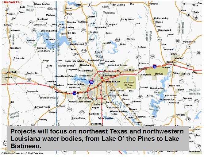
3 Initial Focus is on Caddo Lake but all projects are intended to be easily adaptable to other water bodies.
4 The thrust of the CLI proposal will be projects that: help improve the effectiveness of chemical and biological controls through enhanced communication and coordination;
5 improve the effectiveness of chemical and biological controls through enhanced communication and coordination; stimulate Early Detection/Rapid Response (ED/RR) actions;
6 improve the effectiveness of chemical and biological controls through enhanced communication and coordination; stimulate Early Detection/Rapid Response (ED/RR) actions; engage shoreline residents and frequent visitors to help contain and control giant salvinia and other invasives in their waters;
7 improve the effectiveness of chemical and biological controls through enhanced communication and coordination; stimulate Early Detection/Rapid Response (ED/RR) actions; engage shoreline residents and frequent visitors to help contain and control giant salvinia and other invasives in their waters; create public awareness that helps prevent the migration of giant salvinia and other invasives from one water body to another.
8 Four projects under consideration 1. Chemical & Biological Control Managers Coordination System. 2. Weed Warden program. 3. Shoreline Watch program. 4. Public awareness campaign.
9 Benefits of improved coordination among Chemical & Biological managers Enhanced Rapid Response. Prevent redundant spraying & over spraying. Prevent spraying in biological release areas. Improve cost effectiveness.
10 Chemical & Biological Control Managers Coordination System Challenge: increase communication and cooperation among all entities engaged in chemical & biological control actions at Caddo Lake. Answer: Use available technology to create an interactive web platform for C&B managers to track all C&B activities.

11 Website based C&B managers interactive map tracking system functions 24/7 access to all managers Each manager represented by unique icon on screen at every location he has conducted a C or B action. Vertical & horizontal scroll Zoom in or out

12 When cursor hovers over any icon, pop-up boxes reveal C&B actions at that location, stacked chronologically with most recent on top.

13 Clicking on any pop-up box summons detailed report of that specific action.
14 C&B Managers update map with fill-in-the-blanks data base tool. Password/security code protected GPS coordinates, date. Actions taken: Compounds applied? Weevils released? Contractor ID Size of area treated.????? Database structured for any information C&B mgrs need.

15 As soon as entered, new activity is represented on map and all information is available to other managers and viewable by public.


16 The proposed map tracking platform will provide chemical & biological control managers tools to improve coordination and communication.


17 Database system would also provide C&B managers a rolling log of all C&B activities and monthly treatment reports at the touch of a few keystrokes.

18 Interactive map tracking applications can also provide useful tools for volunteers to assist in the control of giant salvinia and other invasives.
19 Volunteer & Community participation can play important role in control of giant salvinia and other invasives. Prevention via boater education & boat ramp vigilance. Early Detection of new infestations. Small batch removals. Support for agencies. Manpower for special projects.

20 The geodata base developed for the C & B managers coordination system would also provide a platform for reports & information exchange from a select group of volunteers who monitored specific areas of the lake on a regular basis.
21 Caddo Lake Weed Wardens Select group of volunteers recruited & trained to regularly monitor a specific area of the lake. Provide reliable Early Detection reports for action by C&B managers. Make other useful observations in their sector and post them on interactive map website.


22 Viewers can click on a specific area of the lake and view information & photos provided by Weed Warden in that area.
23 Weed Wardens have a passionate interest in protecting the lake; have access to appropriate vessels or vehicles; knowledgeable and interested in lake ecology; conform to certain requirements regarding observations and reporting activities.
24 Weed Wardens Receive special training & tools. Registered to input data, photos & text into interactive website. Special recognition. Other incentives/benefits.
25 Shoreline Watch A website based virtual community of shoreline residents & frequent visitors. Website would be the portal to public viewing of C&B managers & Weed Warden sites. Up-to-date information about giant salvinia & other invasives.


26 Website would include plant & animal identification guides, videos & photo instructional material, and links to other sites with valuable information of interest to lake communities.
27 Shoreline Watch website might also include Community bulletin board. Discussion forum for registered users. Photo gallery where registered users can upload photos. Links to all lake oriented sites, such as B&Bs, marinas, guide services, restaurants. Sponsor participation.
28 Chemical & Biological Control Managers Coordination System. Weed Warden program. Shoreline Watch program. Public awareness campaign.
29 Campaign to target boat owners, adapting TPWD materials where possible. Will stress precautions to be taken to avoid transporting giant salvinia & other invasives from one location to another. Public service radio, TV, and print. Billboards. Posters & signage near boat ramps & marinas. Gasoline pump toppers. Contributed articles, op-ed pieces, & editorials. Promo items such as fish rulers, boat key floats, etc. Brochures/ID Guides. Press releases and story ideas. Social networks and website links.
30 To make these programs effective, your ideas, recommendations, and other input is wanted & needed on these and any issues. Lakes or water bodies that should be included. Features & functions for interactive map-tracking system for CBC managers and Weed Wardens. Features & functions for Shoreline Watch website. Useful information for Weed Wardens to report on in addition to invasives. Other aquatic invasives to watch for. Potential partners at Caddo Lake and elsewhere.
31 Strategies for Control of Giant Salvinia and Other Invasive Species Projects under consideration for a Caddo Lake Institute grant proposal to the National Fish & Wildlife Foundation
Texas A&M AgriLife Extension Service Texas Water Resources Institute
 Texas A&M AgriLife Extension Service Texas Water Resources Institute Quarterly Progress Report Water Quality at Caddo Lake Center for Invasive Species Eradication: Caddo Lake Giant Salvinia Eradication
Marine Debris in the Gulf of Mexico
 Marine Debris in the Gulf of Mexico Peter Murphy NOAA Marine Debris Program / Genwest Biloxi, Mississippi October 25, 2009 Outline 1. Project Background 2. Process 3. 2006-2007 Alabama, Mississippi 4.
Virginia Shoreline Mapping Tools
 Virginia Shoreline Mapping Tools December 15, 2017 Karen Duhring Center for Coastal Resources Management Virginia Institute of Marine Science College of William & Mary Virginia Shoreline Mapping Tools
European Solar Days May Report Spain
 European Solar Days 2009 12-22 May Report Spain Support by: 1 Results of European Solar Days 2009 in Spain 1.1. Participation in European Solar Days 2009 The 2 nd Edition of the European Solar Days organised
Giant Salvinia Overview & History Restore America s Estuaries & The Coastal Society 2016 Summit December 15, 2016
 Giant Salvinia Overview & History Restore America s Estuaries & The Coastal Society 2016 Summit December 15, 2016 Jillian Day Aquatic Plant Control Coordinator Inland Fisheries Giant Salvinia Native to
Your web browser (Safari 7) is out of date. For more security, comfort and. the best experience on this site: Update your browser Ignore
 is out of date. For more security, comfort and. the best experience on this site: Update your browser Ignore") Your web browser (Safari 7) is out of date. For more security, comfort and Activityengage the best experience on this site: Update your browser Ignore Introduction to GIS What is a geographic information
Your web browser (Safari 7) is out of date. For more security, comfort and Activityengage the best experience on this site: Update your browser Ignore Introduction to GIS What is a geographic information
SPONSORSHIP GOLD SILVER BRONZE WHAT? WHEN? WHERE? HOW MUCH?
 SPONSORSHIP WHAT? P u r p l e D a y 2 0 1 8 i s a s e r i e s o f c o m m u n i t y e v e n t s c o o r d i n a t e d b y a n a r m y o f v o l u n t e e r s a n d f u n d r a i s e r s n a t i o n a l
Google Maps and Beyond
 Google Maps and Beyond Aaron Paul First American Title apaul@firstam.com 2015 APRA Symposium Association of Professional Reserve Analysts May 2 nd, 2015 Google Maps and Beyond - Overview Business case
Interagency Giant Salvinia Control Team
 Interagency Giant Salvinia Control Team 2 nd Meeting Karnack Civic Center, Karnack Texas February 3, 2010 Welcome from Caddo Lake Institute Rick Lowerre, President, CLI Provided room, refreshments and
Water Atlas Overview. Myakka River Management Coordinating Council June 22, 2012 Englewood, Florida
 Water Atlas Overview Myakka River Management Coordinating Council June 22, 2012 Englewood, Florida What is the Water Atlas? A data warehouse A set of interactive maps A collection of tools for viewing/analyzing
StormReady Supporter Application Form updated by NWS Chanhassen on April 7, Name of Applying Entity: Point of Contact: Title:
 NATIONAL WEATHER SERVICE 1733 Lake Drive West Chanhassen, Minnesota www.weather.gov/twincities www.stormready.noaa.gov 952-361-6671, todd.krause@noaa.gov StormReady Supporter Application Form updated by
Rainforests and Deserts: Distribution, Uses, and Human Influences. Teacher s Masters California Education and the Environment Initiative
 E Teacher s Masters California Education and the Environment Initiative Earth Science Standard E.5.e. Rainforests and Deserts: Distribution, Uses, and Human Influences California Education and the Environment
Think Global, Map Local! Introducing the. Open Green Map
 Think Global, Map Local! Introducing the Open Green Map Green Map System: Promoting inclusive participation in sustainable community development since 1995 Engaging over 550 communities in 54 countries,
Using Technology to Report Invasive Species in Indiana via EDDMapS and the GLEDN Smartphone/Tablet App
 Using Technology to Report Invasive Species in Indiana via EDDMapS and the GLEDN Smartphone/Tablet App Rebekah D. Wallace, Charles T. Bargeron, and Karan A. Rawlins Background University of Georgia BS
Briggs Lake Water Quality Report 2014
 Briggs Lake Water Quality Report 2014 Seasonal Report for Briggs Lake Green Oak Township, Livingston Co. T1N, R6E, Sec. 3,4 74 Surface Acres 414 Hadley Street Holly, MI 48442 Main Phone: 248-634-8388 Northern
Environmental Response Management Application
 Environmental Response Management Application Coastal Response Research Center Nancy Kinner, Michele Jacobi, Rob Braswell, Kurt Schwehr & Amy Merten RRT III May 14, 2008 1 Talk Outline Overview of Center
Danmarks Miljøportal The Danish Natural Environment Portal
 Danmarks Miljøportal The Danish Natural Environment Portal 2 Agenda What s The Danish Natural Environment Portal. Short live demo of Danmarks Arealinformation, with special focus on the inspire layers,
GMES and AFRICA Support Programme 1st technical committee meeting
 GMES and AFRICA Support Programme 1st technical committee meeting Developing an Earth Observation Operational Application for Coastal Ecosystems Mapping, Monitoring and Assessment of the Northern African
Texas A&M AgriLife Extension Service Texas Water Resources Institute
 Texas A&M AgriLife Extension Service Texas Water Resources Institute Quarterly Progress Report Water Quality at Caddo Lake Center for Invasive Species Eradication: Caddo Lake Giant Salvinia Eradication
Middle School. Teacher s Guide MICROPLANTS MAJOR SPONSOR:
 Middle School Teacher s Guide MICROPLANTS MAJOR SPONSOR: Introduction As technology continues to rapidly evolve, scientists are able to collect and store more data. Some scientists find themselves with
Framework on reducing diffuse pollution from agriculture perspectives from catchment managers
 Framework on reducing diffuse pollution from agriculture perspectives from catchment managers Photo: River Eden catchment, Sim Reaney, Durham University Introduction This framework has arisen from a series
The Midwest Invasive Species Information Network: Today and Tomorrow
 The Midwest Invasive Species Information Network: Today and Tomorrow Amos H. Ziegler Applied Spatial Ecology and Technical Services Laboratory Department of Entomology, Michigan State University RRIP IT
Data Uploads 6: Instructions for Inventory
 Data Uploads 6: Instructions for Inventory Explanation of Required, Recommended, and Optional Fields Frequently Asked Questions about Uploading Chemical Data Once the other necessary data have been loaded
OECD QSAR Toolbox v.3.0
 OECD QSAR Toolbox v.3.0 Step-by-step example of how to categorize an inventory by mechanistic behaviour of the chemicals which it consists Background Objectives Specific Aims Trend analysis The exercise
Solving Absolute Value Equations and Inequalities
 Solving Absolute Value Equations and Inequalities Say Thanks to the Authors Click http://www.ck1.org/saythanks (No sign in required) To access a customizable version of this book, as well as other interactive
Internal Audit Report
 Internal Audit Report Right of Way Mapping TxDOT Internal Audit Division Objective To determine the efficiency and effectiveness of district mapping procedures. Opinion Based on the audit scope areas reviewed,
VT STATEWIDE PROPERTY PARCEL MAPPING PROJECT & PROGRAM
 VT STATEWIDE PROPERTY PARCEL MAPPING PROJECT & PROGRAM BUILDING A FOUNDATIONAL MAPPING DATA LAYER Leslie Pelch, VCGI April 2017 WHAT ARE THE STATEWIDE PROPERTY PARCEL MAPPING PROJECT & PROGRAM? A project
Reuse, Recycle: How to Repurpose Your Content. and Make the Big Bucks
 P O W E R Reuse, Recycle: How to Repurpose Your Content and Make the Big Bucks 1 2 AS H L E Y W AR D Corporate Speaker SEMrush I N T E R N A T I O N A L S P E A K E R W R I T E R F O R S E A R C H E N
OECD QSAR Toolbox v.3.3. Step-by-step example of how to categorize an inventory by mechanistic behaviour of the chemicals which it consists
 OECD QSAR Toolbox v.3.3 Step-by-step example of how to categorize an inventory by mechanistic behaviour of the chemicals which it consists Background Objectives Specific Aims Trend analysis The exercise
Continental Divide National Scenic Trail GIS Program
 CDNST Vision Statement: Provide the most accurate geospatial locational information of the Continental Divide Trail and nearby resources to the public as well as help provide internal management information
McIDAS-V Tutorial Displaying Point Observations from ADDE Datasets updated July 2016 (software version 1.6)
") McIDAS-V Tutorial Displaying Point Observations from ADDE Datasets updated July 2016 (software version 1.6) McIDAS-V is a free, open source, visualization and data analysis software package that is the
McIDAS-V Tutorial Displaying Point Observations from ADDE Datasets updated July 2016 (software version 1.6) McIDAS-V is a free, open source, visualization and data analysis software package that is the
S ui t e 2, Gr ound F l oor, T ower B usi ness Cent r e, T ower S t r eet, S wat ar B K R Mal t a T. ( ) / 5 E.
 / 5 E.") S ui t e 2, Gr ound F l oor, T ower B usi ness Cent r e, T ower S t r eet, S wat ar B K R 4 0 1 3 - Mal t a T. ( + 3 5 6 ) 2 1 2 3 2 2 2 4 / 5 E. j obs@ v acancy cent r e. com V A CA NCY CE NT R E. COM
S ui t e 2, Gr ound F l oor, T ower B usi ness Cent r e, T ower S t r eet, S wat ar B K R 4 0 1 3 - Mal t a T. ( + 3 5 6 ) 2 1 2 3 2 2 2 4 / 5 E. j obs@ v acancy cent r e. com V A CA NCY CE NT R E. COM
Scottish Atlas of Variation
 Scottish Atlas of Variation User Guide March 2019 Contents Introduction... 3 Accessing the Atlas of Variation... 3 Dashboard... 4 Introduction... 4 Drop-down menus... 5 Explore icon... 5 Information icons...
Trade Show Planning Timeline by Cory Ann Ellis
 Trade Planning Timeline Action +2 9-2 6-9 3-6 -3 At the < After Action +2 9-2 6-9 3-6 -3 At the < After Select your show(s) Clarify Value of Research: cost, history, # of attendees, ROI, past vendors,
OUTREACH TERC.UCDAVIS.EDU
 E D U C AT I O N A N D OUTREACH 12 TERC education and outreach Part of TERC s mission is education and outreach. Our public, K-12, teacher professional development, and volunteer programs are designed
Discovering Math Concepts in Advanced Algebra Teacher s Guide
 Discovering Math Concepts in Advanced Algebra Teacher s Guide Grade Level: 10 12 Curriculum Focus: Mathematics Lesson Duration: Three class periods Program Description Concepts in Advanced Algebra Calculate
What is a King Tide? How frequently do King Tides happen?
 2 Contents What is a King Tide?... 3 What Can You Do?... 3 King Tide Kit... 6 King Tide Dates & Times 2017... 6 Tidal Flooding Locations... 8 How to Report Data... 8 Steps to Document Flooding:... 11 Using
ON SITE SYSTEMS Chemical Safety Assistant
 ON SITE SYSTEMS Chemical Safety Assistant CS ASSISTANT WEB USERS MANUAL On Site Systems 23 N. Gore Ave. Suite 200 St. Louis, MO 63119 Phone 314-963-9934 Fax 314-963-9281 Table of Contents INTRODUCTION
Citizen Science at the. U.S. Geological Survey
 Citizen Science at the U.S. Geological Survey David Applegate USGS Associate Director for Natural Hazards NRC Board on Earth Science & Resources December 5, 2014 U.S. Department of the Interior U.S. Geological
mylab: Chemical Safety Module Last Updated: January 19, 2018
 : Chemical Safety Module Contents Introduction... 1 Getting started... 1 Login... 1 Receiving Items from MMP Order... 3 Inventory... 4 Show me Chemicals where... 4 Items Received on... 5 All Items... 5
National Survey on the Natural Environment of Japan. Hajime Hirosawa Biodiversity Center of Japan Ministry of the Environment (MOE)
") National Survey on the Natural Environment of Japan Hajime Hirosawa Biodiversity Center of Japan Ministry of the Environment (MOE) Biodiversity Center of Japan, MOE Establishment: 1998 Purpose: to encourage
National Survey on the Natural Environment of Japan Hajime Hirosawa Biodiversity Center of Japan Ministry of the Environment (MOE) Biodiversity Center of Japan, MOE Establishment: 1998 Purpose: to encourage
Coastal Response Research Center. Nancy Kinner University of New Hampshire (UNH) Michele Jacobi NOAA ORR. September 27, 2007
 Michele Jacobi NOAA ORR. September 27, 2007") Coastal Response Research Center Nancy Kinner University of New Hampshire (UNH) Michele Jacobi NOAA ORR September 27, 2007 1 Coastal Response Research Center (CRRC) CRRC is partnership between NOAA s Office
Coastal Response Research Center Nancy Kinner University of New Hampshire (UNH) Michele Jacobi NOAA ORR September 27, 2007 1 Coastal Response Research Center (CRRC) CRRC is partnership between NOAA s Office
Spatial Data Availability Energizes Florida s Citizens
 NASCIO 2016 Recognition Awards Nomination Spatial Data Availability Energizes Florida s Citizens State of Florida Agency for State Technology & Department of Environmental Protection Category: ICT Innovations
Outline of Japan Heritage Program
 March 2015 Agency for Cultural Affairs Outline of Japan Heritage Program I. Background for creating Japan Heritage program The Act on Protection of Cultural Properties has been the basis for cultural properties
Basic Training Battlemind to Home Symposium. Sept
 Basic Training Battlemind to Home Symposium Sept 2017 1 What is Measuring Communities? A social indicators project which allows users to obtain military-specific information about communities strengths
GIS for Crime Analysis. Building Better Analysis Capabilities with the ArcGIS Platform
 GIS for Crime Analysis Building Better Analysis Capabilities with the ArcGIS Platform Crime Analysis The Current State One of the foundations of criminological theory is that three things are needed for
Citizen Science and Arctic Observing: Using the Internet and Simple Technologies to Improve Understanding of Arctic Ecosystem Change
 Citizen Science and Arctic Observing: Using the Internet and Simple Technologies to Improve Understanding of Arctic Ecosystem Change Maribeth S. Murray 1, Phillip A. Loring 2, Howard Ferren 3 and Rebekka
NJ Community Collaborative Rain, Hail and Snow Network
 NJ Community Collaborative Rain, Hail and Snow Network Mathieu Gerbush NJ Assistant State Climatologist/Climate Services Co-CoCoRaHS Coordinator NJ Agricultural Experiment Station School of Environmental
Spatial Optimization of CoCoRAHS Network in Tennessee. Joanne Logan Department of Biosystems Engineering and Soil Science University of Tennessee
 Spatial Optimization of CoCoRAHS Network in Tennessee Joanne Logan Department of Biosystems Engineering and Soil Science University of Tennessee Abstract CoCoRaHS (Community Collaborative Rain, Hail and
The slide pack supports the version 3.0 of the Catchment Data Explorer application, released 25/06/2018
 The slide pack supports the version 3.0 of the Catchment Data Explorer application, released 25/06/2018 The website is here: http://environment.data.gov.uk/catchment-planning/ 1 SECURITY MARKING: PROTECT
SWEDISH SDI DEVELOPMENT & IMPLEMENTATION OF INSPIRE
 SWEDISH SDI DEVELOPMENT & IMPLEMENTATION OF INSPIRE Christina Wasström, Lantmäteriet, 801 82 Gävle, Sweden, christina.wasstrom@lm.se ABSTRACT The Swedish Government and Parliament has given Lantmäteriet
Status of implementation of the INSPIRE Directive 2016 Country Fiches. COUNTRY FICHE Malta
 Status of implementation of the INSPIRE Directive 2016 Country Fiches COUNTRY FICHE Malta Introduction... 1 1. State of Play... 2 1.1 Coordination... 2 1.2 Functioning and coordination of the infrastructure...
MUNICIPALITY OF ANCHORAGE PUBLIC TRANSPORTATION DEPARTMENT AnchorRIDES TRANSPORTATION SYSTEM
 Purpose: The Public Transportation Department and contracted provider will provide safe transportation for AnchorRIDES customers and employees during severe weather or emergency conditions. AnchorRIDES
Evaluating Physical, Chemical, and Biological Impacts from the Savannah Harbor Expansion Project Cooperative Agreement Number W912HZ
 Evaluating Physical, Chemical, and Biological Impacts from the Savannah Harbor Expansion Project Cooperative Agreement Number W912HZ-13-2-0013 Annual Report FY 2017 Submitted by Sergio Bernardes and Marguerite
Your Virtual Workforce. On Demand. Worldwide. COMPANY PRESENTATION. clickworker GmbH 2017
 Your Virtual Workforce. On Demand. Worldwide. COMPANY PRESENTATION 2017 CLICKWORKER AT A GLANCE Segment: Paid Crowdsourcing / Microtasking Services: Text Creation (incl. SEO Texts), AI-Training Data, Internet
The Pace of Change Is Accelerating Creating Many Challenges
 VISION The Pace of Change Is Accelerating Creating Many Challenges Evidence Threatening Our Natural World and Our Future as Humans Social Conflict Mass Migration Ocean Acidification Food Population Urbanization
Geodatabase: Best Practices. Robert LeClair, Senior Instructor
 Geodatabase: Best Practices Robert LeClair, Senior Instructor Agenda Geodatabase Creation Data Ownership Data Model Data Configuration Geodatabase Behaviors Data Validation Extending Performance Geodatabase
Create your own map for tidepooling, beach field trips, boating, camping, kayaking, fishing, and exploring the beaches in Southcentral Alaska.
 Create your own map for tidepooling, beach field trips, boating, camping, kayaking, fishing, and exploring the beaches in Southcentral Alaska. Here s an opportunity to download and customize your own free
Geo-identification and pedestrian navigation with geo-mobile applications: how do users proceed?
 TU Vienna presentation 17 th July 2008 Geo-identification and pedestrian navigation with geo-mobile applications: how do users proceed? Ioannis Delikostidis Corné van Elzakker INTERNATIONAL INSTITUTE FOR
Participatory GIS (PGIS)
") Participatory GIS (PGIS) Join public opinions as an information source into environmental decision-making ESRM 250. May, 29 th, 2012 Mu-Ning Wang wang0209@uw.edu GIS is... A Mapping Tool An Analysis Tool
Participatory GIS (PGIS) Join public opinions as an information source into environmental decision-making ESRM 250. May, 29 th, 2012 Mu-Ning Wang wang0209@uw.edu GIS is... A Mapping Tool An Analysis Tool
Whitepaper. All Currency, One Wallet!
 Whitepaper BitStupm All Currency, One Wallet! All Currency, One Wallet! TABLE OF CONTENTS: BitStupm 1. WHAT IS CRYPTOCURRENCY? 2. HISTORY OF CRYPTOCURRENCY. 3. STRENGTH OF CRYPTOCURRENCY. 4. WHAT IS BITS?
Write a report (6-7 pages, double space) on some examples of Internet Applications. You can choose only ONE of the following application areas:
 on some examples of Internet Applications. You can choose only ONE of the following application areas:") UPR 6905 Internet GIS Homework 1 Yong Hong Guo September 9, 2008 Write a report (6-7 pages, double space) on some examples of Internet Applications. You can choose only ONE of the following application
UPR 6905 Internet GIS Homework 1 Yong Hong Guo September 9, 2008 Write a report (6-7 pages, double space) on some examples of Internet Applications. You can choose only ONE of the following application
Web-based Tools for Complex Spatial Data. Bill Daigle Montana Fish, Wildlife & Parks
 Web-based Tools for Complex Spatial Data Bill Daigle Montana Fish, Wildlife & Parks 1960s - Fisheries Bureau started centralizing data 1980s - Data computerized NW Power Act -> Montana Rivers Study-> Montana
CREATING A REPORT ON FIRE (April 2011)
") CREATING A REPORT ON FIRE (April 2011) The Fire Report feature on the NAFI website lets you create simple summaries of fire activity for areas of land in far northern Australia (north of 20 degrees where
CREATING A REPORT ON FIRE (April 2011) The Fire Report feature on the NAFI website lets you create simple summaries of fire activity for areas of land in far northern Australia (north of 20 degrees where
GIS Geographic Information Systems
 GIS Geographic Information Systems Connecting your Community Ruekert Mielke WAUKESHA WHO WE ARE DATE ESTABLISHED 1946 SERVING LOCAL PEOPLE. SOLVING LOCAL PROBLEMS. TYPE OF ORGANIZATION Ruekert & Mielke,
SCAUG Community Maps Building a Living Atlas of the World
 SCAUG Community Maps Building a Living Atlas of the World Mark Stewart Topics: SCAUG ArcGIS Online Overview Community Maps Overview Community Maps Workflow Update Process Utilizing Your Contribution Community
2018/1 The integration of statistical and geospatial information. The Regional Committee of UN-GGIM: Americas:
 The following are the conclusions and recommendations of the Regional Committee of the United Nations on Global Geospatial Information Management for the Americas, during its Fifth Session, Thursday 8
Quantum Series Product Catalog
 Measuring and Managing Healthy Living Quantum Series Product Catalog RJL Sciences is an FDA registered company RJL Sciences, Inc. 33939 Harper Avenue Clinton Township, MI 48035 USA Voice: 1-800-528-4513
Map-based Public Awareness Building System for Disaster Prevention
 90 Map-based Public Awareness Building System for Disaster Prevention Akira HATTORI, Sayaka MATSUMOTO, Takami YASUDA, and Shigeki YOKOI Kanagawa Institute of Technology, Japan Graduate School of Human
Distribution of Hydrilla and Giant Salvinia in Mississippi in 2005
 An Annual Report to the Mississippi Bureau of Plant Industry for 2005 John D. Madsen, Ryan M. Wersal, and Wilfredo Robles GeoResources Institute and Department of Plant and Soil Science Mississippi State
Notifications and Accretions: Facility Role
 Notifications and Accretions: Facility Role Goal: Learn to view and resolve notification and accretion discrepancies in CROWNWeb. Estimated Time: 25 to 30 minutes PDF: Download a screen reader compatible
BOUNDARY MAP USER GUIDE
 BOUNDARY MAP USER GUIDE Get Exploring. Boundaries. The Northern Ontario Boundary Map provides users with the ability to explore the many community, administrative and service provider boundaries in the
Your web browser (Safari 7) is out of date. For more security, comfort and the best experience on this site: Update your browser Ignore
 is out of date. For more security, comfort and the best experience on this site: Update your browser Ignore") Your web browser (Safari 7) is out of date. For more security, comfort and the best experience on this site: Update your browser Ignore Activityapply MEASU RING DISTANCES O N A MAP How can you use a map
Your web browser (Safari 7) is out of date. For more security, comfort and the best experience on this site: Update your browser Ignore Activityapply MEASU RING DISTANCES O N A MAP How can you use a map
Esri s Living Atlas of the World Community Maps
 Esri s Living Atlas of the World Community Maps Seth Sarakaitis Wednesday May 7, 2014 ArcGIS Living Atlas Concept Living Atlas Content Tour Contributing to the Living Atlas (Community Maps) Seth Sarakaitis
GIS Geographical Information Systems. GIS Management
 GIS Geographical Information Systems GIS Management Difficulties on establishing a GIS Funding GIS Determining Project Standards Data Gathering Map Development Recruiting GIS Professionals Educating Staff
Aboriginal communities strengthen governance with location-based tools in the 21st century
 Aboriginal communities strengthen governance with location-based tools in the 21st century Today, Aboriginal communities are taking advantage of the geomatics technologies that underpin popular online
GPS Mapping with Esri s Collector App. What We ll Cover
 GPS Mapping with Esri s Collector App Part 1: Overview What We ll Cover Part 1: Overview and requirements Part 2: Preparing the data in ArcGIS for Desktop Part 3: Build a web map in ArcGIS Online Part
Wisconsin s Invasive Species Classification Assessment and Rule
 Wisconsin s Invasive Species Classification Assessment and Rule The Process Legislature gave WIDNR authority to create an invasive species classification system. Legislature also created Wis. Council on
Evaluating Physical, Chemical, and Biological Impacts from the Savannah Harbor Expansion Project Cooperative Agreement Number W912HZ
 Evaluating Physical, Chemical, and Biological Impacts from the Savannah Harbor Expansion Project Cooperative Agreement Number W912HZ-13-2-0013 Second Quarterly Report - 2017 Submitted by Sergio Bernardes
Introducing the. a partnership of
 Introducing the a partnership of Background Need for online atlas identified by managers and researchers to make coastal data available Shoreline data Ocean and coastal resources Sea-level rise potential
GLOBAL NEEDS TO BE ADDRESSED IN A STRATEGIC PLAN FOR SPACE WEATHER. Developing products and services in space weather: Space Weather Channel in China
 WORLD METEOROLOGICAL ORGANIZATION COMMISSION FOR BASIC SYSTEMS COMMISSION FOR AERONAUTICAL METEOROLOGY INTER-PROGRAMME COORDINATION TEAM ON SPACE WEATHER ICTSW-4/Doc. 10.2(2) (25.XI.2013) ITEM: 10.2 FOURTH
Virtual Beach Building a GBM Model
 Virtual Beach 3.0.6 Building a GBM Model Building, Evaluating and Validating Anytime Nowcast Models In this module you will learn how to: A. Build and evaluate an anytime GBM model B. Optimize a GBM model
Plow Camera and Location Sharing Practices. National Rural ITS Conference October 23, 2018
 Plow Camera and Location Sharing Practices National Rural ITS Conference October 23, 2018 Outline NWP Program Overview Project Background Purpose What we did State Summaries ID, MT, ND, MN, IA, PA Project
Application for Geotourism Charter
 Application for Geotourism Charter Thank you for the interest in geotourism as a long-term strategy to foster wisely managed tourism and enlightened destination stewardship. National Geographic s Center
Community Mapping Network. Selected Coastal Atlases and Information Systems in British Columbia, Canada
 Community Mapping Network Selected Coastal Atlases and Information Systems in British Columbia, Canada Outline Community Mapping Network cmnbc.ca Pacific Coastal Resources Atlas for BC cmnbc.ca The Living
GIS Applications on Environmental Education in Taiwan
 GIS Applications on Environmental Education in Taiwan Track: Education Authors: Yu-Chen Lai, Mei-Ling Yeh, Tien-Yin Chou Abstract GIS is a perfect vehicle to deliver environmental knowledge and spatial
CLICK HERE TO KNOW MORE
 CLICK HERE TO KNOW MORE GeoSpace for Singapore s Whole-of-Government Data Sharing Asia GeoSpatial Forum 17 19 Oct 2011 Lee Kim Haw Singapore Land Authority Introducing Singapore Land Authority Limited
Contents: LEVANTE DE ALMERÍA A INFORMATION SYSTEM OBJECTIVES AND ACTIONS GEOGRAPHIC INFORMATION SYSTEM RESULTS
 Contents: LEGAL FRAMEWORK: BARCELONA CONVENTION AND ICZM PROTOCOL; COASTAL AREAS MANAGEMENT PROGRAMME; CAMP LEVANTE DE ALMERIA; OVERALL AIM AND KEY IDEAS AREA PHASES PROJECT STRUCTURE ACTIVITIES INSTITUTIONAL
Cub Scouts STEM/Nova Exhibit Guide
 Cub Scouts STEM/Nova Exhibit Guide Science Everywhere 1. A. Watch Humpback Whales in the IMAX Theater and then think about the questions below. For more videos and information about this film, check out
Extreme Temperature Protocol in Middlesex-London
 Clean Air Partnership Webinar March 17, 2009 Extreme Temperature Protocol in Middlesex-London Presented by Iqbal Kalsi, MBA, CPHI(C), CCEP iqbal.kalsi@mlhu.on.ca 1 History Informal monitoring, tracking
Data-Sharing Agreement
 Data-Sharing Agreement Contributions to LandMark: The Global Platform of Indigenous and Community Lands This Data-Sharing Agreement provides the standards for contributing data to the LandMark: The Global
Evaluating Physical, Chemical, and Biological Impacts from the Savannah Harbor Expansion Project Cooperative Agreement Number W912HZ
 Evaluating Physical, Chemical, and Biological Impacts from the Savannah Harbor Expansion Project Cooperative Agreement Number W912HZ-13-2-0013 Annual Report FY 2018 Submitted by Sergio Bernardes and Marguerite
STAMP Spa)al Tools for Arc)c Mapping & Planning. Creating an interactive data tool to improve access and usability of Arctic data
al Tools for Arc)c Mapping & Planning. Creating an interactive data tool to improve access and usability of Arctic data") STAMP Spa)al Tools for Arc)c Mapping & Planning Creating an interactive data tool to improve access and usability of Arctic data Mission Provide easy access to physical, chemical, and biological data Network
STAMP Spa)al Tools for Arc)c Mapping & Planning Creating an interactive data tool to improve access and usability of Arctic data Mission Provide easy access to physical, chemical, and biological data Network
GEOGRAPHIC INFORMATION SYSTEMS AND IT SOLUTIONS FOR THE ENVIRONMENT
 GEOGRAPHIC INFORMATION SYSTEMS AND IT SOLUTIONS FOR THE ENVIRONMENT Mission We focus on Solutions is a worldwide operating business offering Geographic Information Systems and IT solutions to assist environmental
GIS: Introductory Guide to MapPlace. Workshop Agenda. How the Maps Work. Geographic Information Systems. -The MapPlace is a web GIS application
 1 Introductory Guide to MapPlace Workshop 2007 Larry Jones MapPlace & Geoscience Databases Pat Desjardins Corporate GIS Gib McArthur Manager, Resource Information Kirk Hancock MINFILE Geologist Ward Kilby
Empowered lives. Resilient nations. Data for People and Planet. powered by
 Empowered lives. Resilient nations. Data for People and Planet powered by Overview As we enter the fourth industrial revolution, technology is revolutionizing our ability to map nature. Satellite data
Kīlauea Volcano: Be a Volcanologist. Image Credit: Julien Millet / Unsplash. Final Project
 The Kīlauea Volcano: Be a Volcanologist Image Credit: Julien Millet / Unsplash Final Project Final Project The Kīlauea Volcano: Be a Volcanologist In this two-day project, students apply their previous
SEA LIFE Sydney Aquarium. Penguin Expedition Self-Guided Resource Kit. Secondary 7-10
 SEA LIFE Sydney Aquarium Penguin Expedition Self-Guided Resource Kit Secondary 7-10 Introduction The following material has been developed by the SEA LIFE Sydney Aquarium Education Team to support our
Chantale Bijoux Meteorological Officer
 Chantale Bijoux Meteorological Officer Introduction The Seychelles s National Meteorological Services plays a vital role in providing weather and climate information including severe weather changes, therefore
February 7, Jay Krafthefer, L.S.
 February 7, 2013 Jay Krafthefer, L.S. Introduction Background Web applications References Maps released on the Internet self-service not filed for record referenced by Commissioner s orders (Minn. Statute