ANALYSIS OF THE TEMPORAL DYNAMICS OF SUSPENDED SEDIMENT FLUXES
|
|
|
- Joella Brown
- 5 years ago
- Views:
Transcription

 JEAN VAN")


1 ANALYSIS OF THE TEMPORAL DYNAMICS OF SUSPENDED SEDIMENT FLUXES USING DISCRETE SAMPLING AND CONTINUOUS TURBIDITY MEASUREMENTS IN THE MEUSE AND SCHELDT WATERSHEDS (WALLONIA, BELGIUM) JEAN VAN CAMPENHOUT PHD STUDENT, ASSISTANT PROFESSOR IN ASSOCIATION WITH GEOFFREY HOUBRECHTS, PHD & PROF. FRANÇOIS PETIT 18 th JGM, Chambéry LABORATORY OF HYDROGRAPHY AND FLUVIAL GEOMORPHOLOGY UNIVERSITY OF LIÈGE (BELGIUM) June 27, 2016
2 Structure of the presentation 2 Location of the study area Suspended sediment load in rivers how to measure it? Manual sampling method: application to the Meuse watershed Interpolation & extrapolation using flow rate series Regionalization of denudation rates Automatic sampling method: application to the Scheldt watershed Turbidity measurements analysis Automatic sampling results Comparison of several methods to estimate sediment transport rates Technical issues encountered due to high sediment load concentrations Effects of the sampling frequency on the sediment yield estimation Hysteresis phenomena in high temporal resolution turbidity data Analysis prospects and conclusions


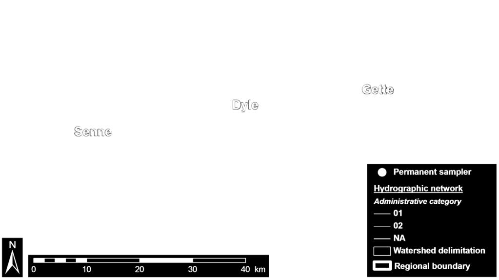
3 Location of the study area 80 measurement stations in Wallonia 3 Belgian loess belt: Quaternary eolian silt deposits covering older geological formations (Paleozoic quartzites, shales, sandstones, limestones, Cretaceous carbonated formations, Caenozoic tabular clayey and sandy formations)

4 Location of the study area Scheldt basin & Meuse basin 4 SCHELDT basin MEUSE basin


 and relationship")

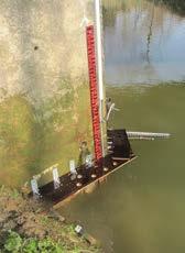
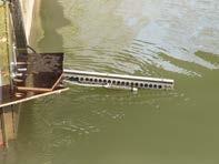
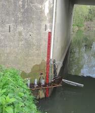
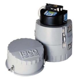
5 Suspended sediment load in rivers how to measure it? 5 Direct measurements: Subsurface or deep manual water sampling (bucket, watertrap, isokinetic sampler, ) Automatic sampling through hose (ISCO samplers) Laboratory analysis: vacuum filtration of samples with 1.2-µm glass fiber filters Direct estimation of the sediment concentration Indirect measurements: Turbidity measurement (backscattered infrared beam) and relationship between the suspended load concentration and the turbidity value (in NTU) Manual subsurface sampling during flood event Watertrap sampling Automatically triggered sampler Turbidity measurement principle Turbidity probe and cleaning device
6 Manual sampling method: application to the Meuse watershed 6 Manual sampling at 80 stations ~ 2,000 samples Uniformity tests in the water column and section Defining relationship SSC = a Q b SSC: susp. sed. concentration (mg.l -1 ) Q: discharge (m 3.s -1 ) a, b: parameters Evaluation of the quality of each relation (R²) SSC (mg.l -1 ) Discharge (m 3.s -1 )
 Quality of the SSC/Q relation Better Intermediate")
7 7 Spatial repartition of the SSC samples and quality of the SSC/Q relations Geographical boundary Hydrographic network # of samples 77 sampled locations Elevation (m) Quality of the SSC/Q relation Better Intermediate Worse
8 Interpolation & extrapolation using discharge series 8 Extrapolation to the whole discharge series to estimate medium-term evolution of the watershed erosion variability Comparison of multiple interpolation and extrapolation techniques taking into account the sampling chronology Estimation of the yearly denudation rate, expressed in t.km -2.yr -1. Source : Delmas et al., 2011: River basin sediment flux assessments
 correction ratio.")
9 Example of yearly denudation rate in the Senne River at Quenast (Scheldt basin) taking into account the Ferguson (1986, 1987) correction ratio. 9 Unavailable flow rate data Necessity to extrapolate from other stations

10 10 Regionalization of denudation rates
11 Regionalization of denudation rates 11 Denudation rates estimated for the period in watersheds ranging from 16 to 2,900 km² Different geographical areas with soil and geology specificities Effect of these environmental settings on the denudation rate: Several hundreds of tons per km² and per year in the loess belt (Senne, Dyle and Gette watersheds) with a huge sensibility to extreme hydrological events Only about 20 t.km -2.yr -1 in Lorraine (no loess, no steep slopes) About 34 t.km -2.yr -1 in Ardenne (shallow soil development, low availability of loamy sediment) Around 69 t.km -2.yr -1 in Entre-Vesdre-et-Meuse, transitional area between the Ardenne and the loess belt. Attempts to correlate the denudation rate with the physical characteristics (soil depth, rainfall intensity, land use, ) but many intricate parameters are involved


12 Additional parameters (particle size distribution, organic matter content) 12 Regionalization of suspended particle size indexes Geographical area #of samples Negative correlation between the a parameter of the SSC equation and the watershed area Mean organic matter proportion in samples collected from November 2007 and November 2010, and the relationship with the mean suspended sediment concentration Land use Deciduous forests Coniferous forests Mixed forests Wastelands Pastures Crops Discontinuous habitat Impervious areas Geographical boundary Simplified hydrographic network Mean susp. sediment concentration (mg.l -1 ) Organic matter Mineral matter a parameter of the equation Watershed area (km²)

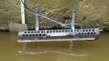
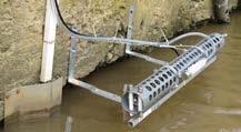
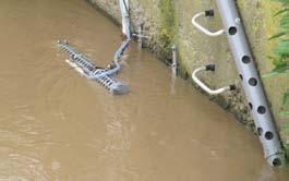
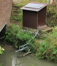
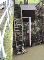
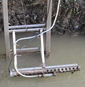
13 Automatic sampling method: application to the Scheldt watershed 13 6 turbidity probes, 4 automatic samplers at 4 locations along the regional border
 Relationship between the inorganic suspended load and the")
14 Turbidity measurements analysis 14 5-min interval turbidity measurements on 4 stations Manual cleaning of outliers or invalid data Example of corrected turbidity data and water level (3rd quarter 2013) Relationship between the inorganic suspended load and the turbidity (Dyle)

15 15 Automatic sampling results
 Corrected data, in t.km -2.year -1 (including Ferguson correction) PETITE GETTE GRANDE GETTE DYLE SENNE 2010 326.5 477.1 240.4 841.9 2011 695.")
16 Comparison of several methods to estimate sediment transport 16 Computation of the sediment budget using the discharge method (link between the SSC and the flow rate) or the turbidity method when data is available (immersed probe, without clogging) Corrected data, in t.km -2.year -1 (including Ferguson correction) PETITE GETTE GRANDE GETTE DYLE SENNE Estimated solid flux on the Senne ; year 2013) comparing discharge and turbidity methods
 100-yr")
17 Raw and corrected monthly sediment yield (using the water discharge method) 100-yr flood
 200-yr")
18 Raw and corrected monthly sediment yield (using the water discharge method) 200-yr flood
 Swipe Uncorrigible mechanism data with through short automatic lifespan algorithms Manual correction of outlier data needed - Waterlevel")
19 Technical issues encountered due to high sediment load concentrations 19 Technical issues due to the clogging of the probes in high sediment concentration environments Impossibility to remove automatically the outliers Turbidity (NTU) Swipe Uncorrigible mechanism data with through short automatic lifespan algorithms Manual correction of outlier data needed - Waterlevel (mm)

 Subsampling tests from continuous data in order to determine the effect of sampling thresholds with control data ; interpretations compared with Skarbøvik et al, 2012: Impact of sampling")
20 20 Effects of the sampling frequency on the sediment yield estimation Comparison of ULg flood-triggered samples and ISSeP monthly samples made at fixed dates (Scientific Institute of Public Service) SSC/discharge relationship Hoëgne at Theux SSC/discharge relationship Hoëgne at Theux No targeting flood events; which effects? Suspended load concentration (mg.l -1 ) Overrepresentation of low rates Underestimation of the solid flow at bank-full discharge Underestimation of the annual denudation rate Suspended load concentration (mg.l -1 ) Discharge (m 3.s -1 ) Subsampling tests from continuous data in order to determine the effect of sampling thresholds with control data ; interpretations compared with Skarbøvik et al, 2012: Impact of sampling frequency on mean concentrations and estimated loads of suspended sediment in a Norwegian river: implications for water management. Discharge (m 3.s -1 )
 Sedimentary behaviour of the watersheds: highlighting hysteresis effects location of the sediment sources and chronology of floods Discharge (m 3.s -1 ) Discharge (m 3.s -1 ) Discharge (m 3.s -1 ) Table 1.")
21 Hysteresis phenomena in high temporal resolution turbidity data 21 Suspended load concentration (mg.l -1 ) Sedimentary behaviour of the watersheds: highlighting hysteresis effects location of the sediment sources and chronology of floods Discharge (m 3.s -1 ) Discharge (m 3.s -1 ) Discharge (m 3.s -1 ) Table 1. Seasonal distribution of each type of hysteresis observed Different types of hysteresis observed in the relation between the concentration of suspended sediment and the discharge during a flood event: - a- Clockwise hysteresis local sediment sources - b- Absence of hysteresis; - c- Counter-clockwise hysteresis distant sediment sources. (according to Dupont et al., 2001) River and type of flood event Spring Summer Fall Winter PETITE GETTE Clockwise hysteresis Counter-clockwise hysteresis GRANDE GETTE Clockwise hysteresis Counter-clockwise hysteresis DYLE Clockwise hysteresis Counter-clockwise hysteresis SENNE Clockwise hysteresis Counter-clockwise hysteresis Counterclockwise hysteresis Clockwise hysteresis Senne 02/05/2012 Senne 17/06/2012
22 Analysis prospects 22 PhD researches are focused on these topics: Long-term flow rate series reconstruction in order to compare denudation rates over the longest time series for about 80 watersheds Comparison of the denudation rates comparison obtained through water sampling with literature data estimated from other techniques (C14, cosmogenic radionuclide dating, dam filling) in the same environmental conditions Estimation of the effects of the sampling frequency on the estimation errors and underestimations Determination of the most appropriate technical solutions to measure the concentration of suspended solids in rivers with high silt/loam load
23 Conclusions 23 Comparison of methods for the estimation of the long-term high resolution denudation rate in 80 watersheds from 16 to 2,900 km² Demonstration of a regional differentiation in the erosion rates, particle size and proportion of organic matter due to soil and land cover differences Evaluation of field issues in turbidity measurement experiments (clogging of the sensors, ) Characterization of flood chronology, sediment sources temporal and spatial relationships through hysteresis analysis Effects of the sampling frequency on the SSC/Q relationships


24 24 24 Dyle, Leuven
Influence of the timing of flood events on sediment yield in the north-western Algeria
 Calabria, 5-7 Septembre 2 4th International Workshop on Hydrological Extremes Session A : Modelling and forecast of hydrological extreme event Influence of the timing of flood events on sediment yield
Application of SWAT Model to Estimate the Runoff and Sediment Load from the Right Bank Valleys of Mosul Dam Reservoir
 Application of SWAT Model to Estimate the Runoff and Sediment Load from the Right Bank Valleys of Mosul Dam Reservoir Dr Mohammad Ezeel Deen Prof. Nadhir Al-Ansari Prof Sven Knutsson Figure 1.Map of Iraq
Assessment of solid load and siltation potential of dams reservoirs in the High Atlas of Marrakech (Moorcco) using SWAT Model
 using SWAT Model") Assessment of solid load and siltation potential of dams reservoirs in the High Atlas of Marrakech (Moorcco) using SWAT Model Amal Markhi: Phd Student Supervisor: Pr :N.Laftrouhi Contextualization Facing
Assessment of solid load and siltation potential of dams reservoirs in the High Atlas of Marrakech (Moorcco) using SWAT Model Amal Markhi: Phd Student Supervisor: Pr :N.Laftrouhi Contextualization Facing
Sediment exports from French rivers. Magalie Delmas, Olivier Cerdan, Jean-Marie Mouchel*, Frédérique Eyrolles, Bruno Cheviron
 Sediment exports from French rivers Magalie Delmas, Olivier Cerdan, Jean-Marie Mouchel*, Frédérique Eyrolles, Bruno Cheviron Université Pierre et Marie Curie, Paris BRGM, Orléans ISRN, Cadarache Study
Sediment yield estimation from a hydrographic survey: A case study for the Kremasta reservoir, Western Greece
 Sediment yield estimation from a hydrographic survey: A case study for the Kremasta reservoir, Western Greece 5 th International Conference Water Resources Management in the Era of Transition,, Athens,
Statistical modelling of suspended sediment transport in the Cherf drainage basin, Algeria
 13 Statistical modelling of suspended sediment transport in the Cherf drainage basin, Algeria K. KHANCHOUL 1, Z-E BOUKHRISSA 1 & H. MAJOUR 2 (Reçu le 09/01/2012 ; Accepté le 15/03/2012) Abstract This work
Surface Processes Focus on Mass Wasting (Chapter 10)
") Surface Processes Focus on Mass Wasting (Chapter 10) 1. What is the distinction between weathering, mass wasting, and erosion? 2. What is the controlling force in mass wasting? What force provides resistance?
Surface Processes Focus on Mass Wasting (Chapter 10) 1. What is the distinction between weathering, mass wasting, and erosion? 2. What is the controlling force in mass wasting? What force provides resistance?
URBAN HYDROLOGY: WATER IN THE CITY OF TSHWANE Plant Sciences Auditorium, University of Pretoria January 2014 URBAN HYDROGEOLOGY
 URBAN HYDROLOGY: WATER IN THE CITY OF TSHWANE Plant Sciences Auditorium, University of Pretoria 23 24 January 2014 URBAN HYDROGEOLOGY MATTHYS A. DIPPENAAR DEPARTMENT GEOLOGY, UNIVERSITY OF PRETORIA HYDROGEOLOGY
Phase I System Characterization: Year 2 Study Plans
 Phase I System Characterization: Year 2 Study Plans Year I Physical and Biological Data Sets Quarterly Storm Sampling Four storm events with 8 sample stations at bridges Monthly Baseline Characterization
Stop 1: Marmot Dam Stop 1: Marmot Dam
 Stop 1: Marmot Dam Stop 1: Marmot Dam Following the removal of Marmot Dam in 2007, the fate of the reservoir sediments has been monitored through a series of surveys and sediment transport measurements.
Squaw Creek. General Information
 General Information is a tributary to the Salmon River. It enters the north side of the river about 0 miles downstream of North Fork, Idaho. The study reach is about a 30 ft length of stream about 2 miles
Introduction. Abstract
 Earth Surface Processes and Landforms Specific Earth Surf. sediment Process. Landforms yield in different 33, 1157 1173 grain size (2008) fractions in the tributaries of the middle Yellow River 1157 Published
Soil Erosion Calculation using Remote Sensing and GIS in Río Grande de Arecibo Watershed, Puerto Rico
 Soil Erosion Calculation using Remote Sensing and GIS in Río Grande de Arecibo Watershed, Puerto Rico Alejandra M. Rojas González Department of Civil Engineering University of Puerto Rico at Mayaguez.
Impact of the Danube River on the groundwater dynamics in the Kozloduy Lowland
 GEOLOGICA BALCANICA, 46 (2), Sofia, Nov. 2017, pp. 33 39. Impact of the Danube River on the groundwater dynamics in the Kozloduy Lowland Peter Gerginov Geological Institute, Bulgarian Academy of Sciences,
Monitoring Headwater Streams for Landscape Response to
 Monitoring Headwater Streams for Landscape Response to Climate Change Matthew Connor, PhD Connor nvironmental, nc. www.oe-i.com icom Healdsburg, California verview Headwater stream geomorphology Response
Each basin is surrounded & defined by a drainage divide (high point from which water flows away) Channel initiation
 Channel initiation") DRAINAGE BASINS A drainage basin or watershed is defined from a downstream point, working upstream, to include all of the hillslope & channel areas which drain to that point Each basin is surrounded &
DRAINAGE BASINS A drainage basin or watershed is defined from a downstream point, working upstream, to include all of the hillslope & channel areas which drain to that point Each basin is surrounded &
Lower Susquehanna River Integrated Sediment & Nutrient Monitoring Program
 Lower Susquehanna River Integrated Sediment & Nutrient Monitoring Program Presented at the Chesapeake Bay Program Scientific and Technical Advisory Committee (STAC) Workshop January 13, 2016 Background
What Is Water Erosion? Aren t they the same thing? What Is Sediment? What Is Sedimentation? How can Sediment Yields be Minimized?
 Jerald S. Fifield, Ph.D. CISEC HydroDynamics Incorporated Parker, CO 303-841-0377 Aren t they the same thing? What Is Sediment? Soil particles deposited or suspended in water or air The process of depositing
3/3/2013. The hydro cycle water returns from the sea. All "toilet to tap." Introduction to Environmental Geology, 5e
 Introduction to Environmental Geology, 5e Running Water: summary in haiku form Edward A. Keller Chapter 9 Rivers and Flooding Lecture Presentation prepared by X. Mara Chen, Salisbury University The hydro
Sediment Capture in Pervious Concrete Pavement tsystems: Effects on Hydrological Performance and Suspended Solids
 Concrete Sustainability Conference April 14 th 2010, Tempe, AZ Sediment Capture in Pervious Concrete Pavement tsystems: Effects on Hydrological l Performance and Suspended Solids Discharge Luis A. Mata,
Determining the Ability of Acid Extractable Metals as a Fingerprint in Sediment Source Discrimination
 International Journal of Natural Resources and Marine Sciences 2011, 1 (2), 93-99 Determining the Ability of Acid Extractable Metals as a Fingerprint in Sediment Source Discrimination Asghar Kouhpeima
Sediment Deposition LET THE RIVER RUN T E A C H E R. Activity Overview. Activity at a Glance. Time Required. Level of Complexity.
 Activity at a Glance Grade: 6 9 Subject: Science Category: Physical Science, Earth Science Topic: Deposition, River Systems Time Required Two 45-minute periods Level of Complexity Medium Materials* TI-73
DETERMINATION OF SEDIMENT TRAP EFFICIENCY OF SMALL WATER RESERVOIR AT KREMPNA
 Determination of sediment trap efficiency INFRASTRUKTURA I EKOLOGIA TERENÓW WIEJSKICH INFRASTRUCTURE AND EKOLOGY OF RURAL AREAS Nr 3/2007, POLSKA AKADEMIA NAUK, Oddział w Krakowie, s. 161 170 Komisja Technicznej
Disentangling Impacts of Climate & Land Use Changes on the Quantity & Quality of River Flows in Southern Ontario
 Disentangling Impacts of Climate & Land Use Changes on the Quantity & Quality of River Flows in Southern Ontario by Trevor Dickinson & Ramesh Rudra, Water Resources Engineering University of Guelph Acknowledgements
Land-use impacts on catchment erosion for the Waitetuna catchment, New Zealand
 Sediment Dynamics in Changing Environments (Proceedings of a symposium held in Christchurch, New Zealand, December 2008). IAHS Publ. 325, 2008. 453 Land-use impacts on catchment erosion for the Waitetuna
STUDY GUIDE FOR CONTENT MASTERY. Surface Water Movement
 Surface Water SECTION 9.1 Surface Water Movement In your textbook, read about surface water and the way in which it moves sediment. Complete each statement. 1. An excessive amount of water flowing downslope
Stream Geomorphology. Leslie A. Morrissey UVM July 25, 2012
 Stream Geomorphology Leslie A. Morrissey UVM July 25, 2012 What Functions do Healthy Streams Provide? Flood mitigation Water supply Water quality Sediment storage and transport Habitat Recreation Transportation
(case study Karaj watershed)
") River sediment monitoring using remote sensing and GIS (case study Karaj watershed) M. Shafaie a,h.ghodosi b, K. H. Mostofi c * a professor, Department of Civil Engineering, Faculty of Engineering, University
River sediment monitoring using remote sensing and GIS (case study Karaj watershed) M. Shafaie a,h.ghodosi b, K. H. Mostofi c * a professor, Department of Civil Engineering, Faculty of Engineering, University
Diagnostic Geomorphic Methods for Understanding Future Behavior of Lake Superior Streams What Have We Learned in Two Decades?
 Diagnostic Geomorphic Methods for Understanding Future Behavior of Lake Superior Streams What Have We Learned in Two Decades? Faith Fitzpatrick USGS WI Water Science Center, Middleton, WI fafitzpa@usgs.gov
CASE STUDY NATHPA JHAKRI, INDIA
 SEDIMENT MANAGEMENT CASE STUDY NATHPA JHAKRI, INDIA Key project features Name: Nathpa Jhakri Country: India Category: reduce sediment production (watershed management); upstream sediment trapping; bypass
Do you think sediment transport is a concern?
 STREAM RESTORATION FRAMEWORK AND SEDIMENT TRANSPORT BASICS Pete Klingeman 1 What is Your Restoration Project Like? k? Do you think sediment transport is a concern? East Fork Lewis River, WA Tidal creek,
12. Sediment transport in the Geba River system
 12. Sediment transport in the Geba River system Amanuel Zenebe 1,*, Matthias Vanmaercke 2,3, Jean Poesen 2, Gert Verstraeten 2, Jan Nyssen 4, Gebreyohannes Girmay 1,2, Mitiku Haile 1, Hans Bauer 1,2, Jozef
Continuing Education Associated with Maintaining CPESC and CESSWI Certification
 Continuing Education Associated with Maintaining CPESC and CESSWI Certification Module 2: Stormwater Management Principles for Earth Disturbing Activities Sponsors: ODOTs Local Technical Assistance Program
Chapter 2. Regional Landscapes and the Hydrologic Cycle
 Chapter 2. Regional Landscapes and the Hydrologic Cycle W. Lee Daniels Department of Crop and Soil Environmental Sciences, Virginia Tech Table of Contents Introduction... 23 Soils and landscapes of the
Study of Suspended Sediment and Its Mineral Content Analysis with Impact on Hydropower Design: A Case Study of Rahughat Hydroelectric Project
 Journal of Geological Resource and Engineering 2 (2017) 82-86 doi:10.17265/2328-2193/2017.02.005 D DAVID PUBLISHING Study of Suspended Sediment and Its Mineral Content Analysis with Impact on Hydropower
APPENDIX E. GEOMORPHOLOGICAL MONTORING REPORT Prepared by Steve Vrooman, Keystone Restoration Ecology September 2013
 APPENDIX E GEOMORPHOLOGICAL MONTORING REPORT Prepared by Steve Vrooman, Keystone Restoration Ecology September 2 Introduction Keystone Restoration Ecology (KRE) conducted geomorphological monitoring in
A distributed runoff model for flood prediction in ungauged basins
 Predictions in Ungauged Basins: PUB Kick-off (Proceedings of the PUB Kick-off meeting held in Brasilia, 2 22 November 22). IAHS Publ. 39, 27. 267 A distributed runoff model for flood prediction in ungauged
Big Wood River. General Information
 General Information The flows out of the southern portion of the Sawtooth National Recreation Area in central Idaho. The study reach is about a,200 ft length of river about.5 miles upstream from the discontinued
11/22/2010. Groundwater in Unconsolidated Deposits. Alluvial (fluvial) deposits. - consist of gravel, sand, silt and clay
 deposits. - consist of gravel, sand, silt and clay") Groundwater in Unconsolidated Deposits Alluvial (fluvial) deposits - consist of gravel, sand, silt and clay - laid down by physical processes in rivers and flood plains - major sources for water supplies
Groundwater in Unconsolidated Deposits Alluvial (fluvial) deposits - consist of gravel, sand, silt and clay - laid down by physical processes in rivers and flood plains - major sources for water supplies
Challenges in Calibrating a Large Watershed Model with Varying Hydrogeologic Conditions
 Challenges in Calibrating a Large Watershed Model with Varying Hydrogeologic Conditions Presented by Johnathan R. Bumgarner, P.G., Celine A.L. Louwers, & Monica P. Suarez, P.E. In cooperation with the
THE UNIVERSITY of TORONTO at SCARBOROUGH January, 2010 Department of Physical & Environmental Sciences
 THE UNIVERSITY of TORONTO at SCARBOROUGH January, 2010 Department of Physical & Environmental Sciences Environmental Science EES B02H3 PRINCIPLES OF GEOMORPHOLOGY The earth s surface form and its dynamic
WATER ON AND UNDER GROUND. Objectives. The Hydrologic Cycle
 WATER ON AND UNDER GROUND Objectives Define and describe the hydrologic cycle. Identify the basic characteristics of streams. Define drainage basin. Describe how floods occur and what factors may make
Erosion Surface Water. moving, transporting, and depositing sediment.
 + Erosion Surface Water moving, transporting, and depositing sediment. + Surface Water 2 Water from rainfall can hit Earth s surface and do a number of things: Slowly soak into the ground: Infiltration
Geomorphology Geology 450/750 Spring Fluvial Processes Project Analysis of Redwood Creek Field Data Due Wednesday, May 26
 Geomorphology Geology 450/750 Spring 2004 Fluvial Processes Project Analysis of Redwood Creek Field Data Due Wednesday, May 26 This exercise is intended to give you experience using field data you collected
The Influence of tropical cyclones as soil eroding and sediment transporting events. An example from the Philippines
 259 Research Needs and Applications to Reduce Erosion and Sedimentation in Tropica! Stecplands (Proceedings of the Fiji Symposium, June 1990): IAHS-AISH Publ. No.192,1990. The Influence of tropical cyclones
Upper Truckee River Restoration Lake Tahoe, California Presented by Brendan Belby Sacramento, California
 Upper Truckee River Restoration Lake Tahoe, California Presented by Brendan Belby Sacramento, California Mike Rudd (Project Manager), Charley Miller & Chad Krofta Declines in Tahoe s Water Clarity The
Nutrient and Sediment Cycling and Retention in Urban Floodplain Wetlands
 Nutrient and Sediment Cycling and Retention in Urban Floodplain Wetlands Greg Noe, Cliff Hupp, Nancy Rybicki, Ed Schenk, and Jackie Batson National Research Program, Reston VA U.S. Department of the Interior
low turbidity high turbidity
 What is Turbidity? Turbidity refers to how clear the water is. The greater the amount of total suspended solids (TSS) in the water, the murkier it appears and the higher the measured turbidity. Excessive
Need of Proper Development in Hilly Urban Areas to Avoid
 Need of Proper Development in Hilly Urban Areas to Avoid Landslide Hazard Dr. Arvind Phukan, P.E. Cosultant/Former Professor of Civil Engineering University of Alaska, Anchorage, USA RI District Governor
SEDIMENT DATA FOR THE LOWER MEKONG
 SEDIMENT DATA FOR THE LOWER MEKONG A review of past monitoring activity and what it tells us about past and recent sediment fluxes and what lessons can be learnt for future monitoring DES WALLING DEPARTMENT
Experience from Sediment Transport Monitoring and Investigations in the Rio Cordon
 Geophysical Research Abstracts, Vol. 7, 06419, 2005 SRef-ID: 1607-7962/gra/EGU05-A-06419 European Geosciences Union 2005 Experience from Sediment Transport Monitoring and Investigations in the Rio Cordon
SPATIAL MODELS FOR THE DEFINITION OF LANDSLIDE SUSCEPTIBILITY AND LANDSLIDE HAZARD. J.L. Zêzere Centre of Geographical Studies University of Lisbon
 SPATIAL MODELS FOR THE DEFINITION OF LANDSLIDE SUSCEPTIBILITY AND LANDSLIDE HAZARD J.L. Zêzere Centre of Geographical Studies University of Lisbon CONCEPTUAL MODEL OF LANDSLIDE RISK Dangerous Phenomena
CAUSES FOR CHANGE IN STREAM-CHANNEL MORPHOLOGY
 CAUSES FOR CHANGE IN STREAM-CHANNEL MORPHOLOGY Chad A. Whaley, Department of Earth Sciences, University of South Alabama, MobileAL, 36688. E-MAIL: caw408@jaguar1.usouthal.edu The ultimate goal of this
Surface Water and Stream Development
 Surface Water and Stream Development Surface Water The moment a raindrop falls to earth it begins its return to the sea. Once water reaches Earth s surface it may evaporate back into the atmosphere, soak
SEDIMENT TRANSPORT IN RIVER MOUTH ESTUARY
 SEDIMENT TRANSPORT IN RIVER MOUTH ESTUARY Katsuhide YOKOYAMA, Dr.Eng. dredge Assistant Professor Department of Civil Engineering Tokyo Metropolitan University 1-1 Minami-Osawa Osawa, Hachioji,, Tokyo,
Environmental Science EES B02H3 PRINCIPLES OF GEOMORPHOLOGY
 THE UNIVERSITY of TORONTO at SCARBOROUGH January, 2009 Department of Physical & Environmental Sciences Environmental Science EES B02H3 PRINCIPLES OF GEOMORPHOLOGY The earth s surface form and its dynamic
Environmental Science Institute The University of Texas - Austin
 Environmental Science Institute The University of Texas - Austin Geologic Wonders of Central Texas Dr. Leon Long This file contains suggestions for how to incorporate the material from this CDROM into
GIS Application in Landslide Hazard Analysis An Example from the Shihmen Reservoir Catchment Area in Northern Taiwan
 GIS Application in Landslide Hazard Analysis An Example from the Shihmen Reservoir Catchment Area in Northern Taiwan Chyi-Tyi Lee Institute of Applied Geology, National Central University, No.300, Jungda
Landscape Development
 Landscape Development Slopes Dominate Natural Landscapes Created by the interplay of tectonic and igneous activity and gradation Deformation and uplift Volcanic activity Agents of gradation Mass wasting
HW #2 Landscape Travel from A to B 12,
 HW #2 Landscape 2016 Section: Name: ate: 1. ase your answer(s) to the following question(s) on the map below, which represents two bridges that cross the Green River. Letters,, and represent locations
Soil Formation. Lesson Plan: NRES B2-4
 Soil Formation Lesson Plan: NRES B2-4 1 Anticipated Problems 1. What are five different factors that affect soil formation? 2. What are some different types of parent material that affect soils? 3. What
A TIPPING-BUCKET SEDIMENT TRAP FOR CONTINUOUS MONITORING OF SEDIMENT DEPOSITION RATE
 A TIPPING-BUCKET SEDIMENT TRAP FOR CONTINUOUS MONITORING OF SEDIMENT DEPOSITION RATE YASUO NIHEI AND YUICHI IMASHIMIZU Department of Civil Eng., Tokyo University of Science, 2641 Yamazaki, Noda-shi 278-851,
CASE STUDY NATHPA JHAKRI, INDIA
 SEDIMENT MANAGEMENT CASE STUDY NATHPA JHAKRI, INDIA Key project features Name: Nathpa Jhakri Country: India Category: reforestation/revegetation; upstream sediment trapping; bypass channel/tunnel; reservoir
Lab 7: Sedimentary Structures
 Name: Lab 7: Sedimentary Structures Sedimentary rocks account for a negligibly small fraction of Earth s mass, yet they are commonly encountered because the processes that form them are ubiquitous in the
Gully erosion in winter crops: a case study from Bragança area, NE Portugal
 Gully erosion in winter crops: a case study from Bragança area, NE Portugal T. de Figueiredo Instituto Politécnico de Bragança (IPB/ESAB), CIMO Mountain Research Centre, Bragança, Portugal Foreword This
Tarbela Dam in Pakistan. Case study of reservoir sedimentation
 Tarbela Dam in Pakistan. HR Wallingford, Wallingford, UK Published in the proceedings of River Flow 2012, 5-7 September 2012 Abstract Reservoir sedimentation is a main concern in the Tarbela reservoir
River Response. Sediment Water Wood. Confinement. Bank material. Channel morphology. Valley slope. Riparian vegetation.
 River Response River Response Sediment Water Wood Confinement Valley slope Channel morphology Bank material Flow obstructions Riparian vegetation climate catchment vegetation hydrological regime channel
ENVIRONMENTAL GEOSCIENCE UNIFORM SYLLABUS
 ENVIRONMENTAL GEOSCIENCE UNIFORM SYLLABUS The Association of Professional Engineers and Geoscientists of the Province of British Columbia Note: 1. This Syllabus May Be Subject To Change 2. These Courses
Technical Notes: Magnitude and Return Period of 2004 Hurricane Rainfall in Florida
 Journal of Floodplain Management Floodplain Management Association NOV. 2005 Vol. 5, No. 1 Glenn Tootle 1 Thomas Mirti 2 Thomas Piechota 3 Technical Notes: Magnitude and Return Period of 2004 Hurricane
Analysis of coarse sediment connectivity in semiarid river channels
 Sediment Transfer tlirongh the Fluviai System (Proceedings of a symposium held in Moscow, August 2004). IAHS Publ. 288, 2004 269 Analysis of coarse sediment connectivity in semiarid river channels J. M.
Introduction Fluvial Processes in Small Southeastern Watersheds
 Introduction Fluvial Processes in Small Southeastern Watersheds L. Allan James Scott A. Lecce Lisa Davis Southeastern Geographer, Volume 50, Number 4, Winter 2010, pp. 393-396 (Article) Published by The
The contribution of gully erosion to the sediment budget of the River Leira
 Variability in Stream Erosion and Sediment Transport (Proceedings of the Canberra Symposium, December 1994). IAHS Publ. no. 224, 1994. 307 The contribution of gully erosion to the sediment budget of the
How Do Geology and Physical Streambed Characteristics Affect Water Quality?
 Teacher s Guide How Do Geology and Physical Streambed Characteristics Affect Water Quality? Lesson Description In this lesson, the students research a dynamic, vertical dimension of a watershed - the geological
Wetland & Floodplain Functional Assessments and Mapping To Protect and Restore Riverine Systems in Vermont. Mike Kline and Laura Lapierre Vermont DEC
 Wetland & Floodplain Functional Assessments and Mapping To Protect and Restore Riverine Systems in Vermont Mike Kline and Laura Lapierre Vermont DEC NWI+ Hydro-Geomorphic Characterization of Wetlands and
Depositional Environments. Depositional Environments
 Depositional Environments Geographic area in which sediment is deposited Characterized by a combination of geological process & environmental conditions Depositional Environments Geological processes:
Watershed concepts for community environmental planning
 Purpose and Objectives Watershed concepts for community environmental planning Dale Bruns, Wilkes University USDA Rural GIS Consortium May 2007 Provide background on basic concepts in watershed, stream,
Distinct landscape features with important biologic, hydrologic, geomorphic, and biogeochemical functions.
 1 Distinct landscape features with important biologic, hydrologic, geomorphic, and biogeochemical functions. Have distinguishing characteristics that include low slopes, well drained soils, intermittent
Debris flow: categories, characteristics, hazard assessment, mitigation measures. Hariklia D. SKILODIMOU, George D. BATHRELLOS
 Debris flow: categories, characteristics, hazard assessment, mitigation measures Hariklia D. SKILODIMOU, George D. BATHRELLOS Natural hazards: physical phenomena, active in geological time capable of producing
Sedimentary Basins. Gerhard Einsele. Springer-Verlag Berlin Heidelberg New York London Paris Tokyo Hong Kong Barcelona Budapest
 Gerhard Einsele Sedimentary Basins Evolution, Facies, and Sediment Budget With 269 Figures Springer-Verlag Berlin Heidelberg New York London Paris Tokyo Hong Kong Barcelona Budapest Contents Part I Types
3.3 CLIMATE, GEOLOGY, TOPOGRAPHY, AND SOILS CLIMATE GEOLOGY TOPOGRAPHY
 3.3 CLIMATE, GEOLOGY, TOPOGRAPHY, AND SOILS This section describes the climate, geology, topography, and soil resource characteristics of the Yolo Bypass Wildlife Area (Wildlife Area). Agricultural soil
In-channel storage of fine sediment in rivers of southwest England
 Sediment Transfer through flic Fluvial System (Proceedings ofthc Moscow Symposium. August 2004). IAHS Publ. 288, 2004 291 In-channel storage of fine sediment in rivers of southwest England A. J. WILSON
Determination of Urban Runoff Using ILLUDAS and GIS
 Texas A&M University Department of Civil Engineering Instructor: Dr. Francisco Olivera CVEN689 Applications of GIS to Civil Engineering Determination of Urban Runoff Using ILLUDAS and GIS Tae Jin Kim 03.
Description DESCRIPTION
 DESCRIPTION The location of the Upper James Watershed is located in northeastern South Dakota as well as southeastern North Dakota. It includes the following counties located in North Dakota Barnes, Dickey,
SPECIFIC DEGRADATION AND RESERVOIR SEDIMENTATION. By Renee Vandermause & Chun-Yao Yang
 SPECIFIC DEGRADATION AND RESERVOIR SEDIMENTATION By Renee Vandermause & Chun-Yao Yang Outline Sediment Degradation - Erosion vs Sediment Yield - Sediment Yield - Methods for estimation - Defining Sediment
Dr Benjamin Dewals, Ir Sylvain Detrembleur, Dr P. Archambeau, Ir L. Gouverneur & Prof. M. Pirotton
 Dr Benjamin Dewals, Ir Sylvain Detrembleur, Dr P. Archambeau, Ir L. Gouverneur & Prof. M. Pirotton Content Hydraulic modelling within AMICE Existing models and modelling procedures Transnational modelling
Sediment Transport and Strata Formation in the Adriatic Sea
 Sediment Transport and Strata Formation in the Adriatic Sea Wayne R. Geyer James D. Irish Peter A. Traykovski Woods Hole Oceanographic Institution Woods Hole, MA 02543 Tel. (508) 289-2868, Fax: (508) 457-2194,
Land-Water Linkages in Rural Watersheds Electronic Workshop 18 September 27 October 2000
 Land-Water Linkages in Rural Watersheds Electronic Workshop 18 September 27 October 2000 Case Study 28 Estimation of basin sediment flux in the Pang Khum Experimental Watershed in Northern Thailand: the
Geology Test Review Answers
 Name: Geology Test Review Answers Core: Fill in the blanks: 1. Sediments get compacted and cemented into sedimentary rock. 2. Igneous rocks can be intrusive or extrusive from a volcano. 3. Adding heat
Water Quality and Water Quantity: Two sides of the Same Coin. Chris Jones
 Water Quality and Water Quantity: Two sides of the Same Coin Chris Jones Unit of the College of Engineering Director: Larry Weber 90 Graduate Students from 16 countries 61 Research Engineers and Scientists
Unit E: Basic Principles of Soil Science. Lesson 2: Understanding Soil Formation
 Unit E: Basic Principles of Soil Science Lesson 2: Understanding Soil Formation Important Terms Alluvium Bedrock Chemical weathering Climate Glacial till Loess Native vegetation Organic matter Outwash
Watershed simulation and forecasting system with a GIS-oriented user interface
 HydroGIS 96: Application of Geographic Information Systems in Hydrology and Water Resources Management (Proceedings of the Vienna Conference, April 1996). IAHS Publ. no. 235, 1996. 493 Watershed simulation
Overview of fluvial and geotechnical processes for TMDL assessment
 Overview of fluvial and geotechnical processes for TMDL assessment Christian F Lenhart, Assistant Prof, MSU Research Assoc., U of M Biosystems Engineering Fluvial processes in a glaciated landscape Martin
Watershed Assessment of River Stability and Sediment Supply: Advancing the Science of Watershed Analysis
 Watershed Assessment of River Stability and Sediment Supply: Advancing the Science of Watershed Analysis 2009 MWEA Annual Conference Rob Myllyoja, CET rmyllyoja@hrc-engr.com Watershed Assessment of River
Assessment of Lake Forest Lake Sediment Trapping Efficiency and Capacity. Marlon R. Cook Groundwater Assessment Program Geological Survey of Alabama
 Assessment of Lake Forest Lake Sediment Trapping Efficiency and Capacity Marlon R. Cook Groundwater Assessment Program Geological Survey of Alabama Impacts of the Lake at Lake Forest on the connectivity
Impacts of climate change on flooding in the river Meuse
 Impacts of climate change on flooding in the river Meuse Martijn Booij University of Twente,, The Netherlands m.j.booij booij@utwente.nlnl 2003 in the Meuse basin Model appropriateness Appropriate model
Sediment- yield estimation, by M-PSIAC method in a GIS environment, case study:jonaghn river sub basin(karun basin)
") Sediment- yield estimation, by M-PSIAC method in a GIS environment, case study:jonaghn river sub basin(karun basin) Yavari-shahla *,Khdabakhsh-Saeed,Mohseni-Hasan, Rezai- Khalil Corresponding author: a
Sediment- yield estimation, by M-PSIAC method in a GIS environment, case study:jonaghn river sub basin(karun basin) Yavari-shahla *,Khdabakhsh-Saeed,Mohseni-Hasan, Rezai- Khalil Corresponding author: a
How Do Human Impacts and Geomorphological Responses Vary with Spatial Scale in the Streams and Rivers of the Illinois Basin?
 How Do Human Impacts and Geomorphological Responses Vary with Spatial Scale in the Streams and Rivers of the Illinois Basin? Bruce Rhoads Department of Geography University of Illinois at Urbana-Champaign
DESCRIPTION OF A HYDROLOGIC DATASET. Department of Environmental Sciences, Wageningen University and. Research Center. Wageningen, The Netherlands
 DESCRIPTION OF A HYDROLOGIC DATASET FOR THE BRISY SUBCATCHMENT R. T. Oosterho? and C. Paniconi y? Department of Environmental Sciences, Wageningen University and Research Center Wageningen, The Netherlands
Floodplain modeling. Ovidius University of Constanta (P4) Romania & Technological Educational Institute of Serres, Greece
 Romania & Technological Educational Institute of Serres, Greece") Floodplain modeling Ovidius University of Constanta (P4) Romania & Technological Educational Institute of Serres, Greece Scientific Staff: Dr Carmen Maftei, Professor, Civil Engineering Dept. Dr Konstantinos
Floodplain modeling Ovidius University of Constanta (P4) Romania & Technological Educational Institute of Serres, Greece Scientific Staff: Dr Carmen Maftei, Professor, Civil Engineering Dept. Dr Konstantinos
Long term in situ observations on typhoon triggered turbidity currents (TC) in the deep sea
 in the deep sea") Long term in situ observations on typhoon triggered turbidity currents (TC) in the deep sea Article in Geology June 2018 Yanwei Zhang1*, Zhifei Liu1, Yulong Zhao1, Christophe Colin2, Xiaodong Zhang1, Meng
Long term in situ observations on typhoon triggered turbidity currents (TC) in the deep sea Article in Geology June 2018 Yanwei Zhang1*, Zhifei Liu1, Yulong Zhao1, Christophe Colin2, Xiaodong Zhang1, Meng