A Roundup of Recent Debris Flow Events in Taiwan
|
|
|
- Clarence Sherman
- 5 years ago
- Views:
Transcription
1 2015 International Workshop on Typhoon and Flood APEC Experience Sharing on Hazardous Weather Events and Risk Management A Roundup of Recent Debris Flow Events in Taiwan Hsiao-Yuan(Samuel) Yin Ph.D. sammya@mail.swcb.gov.tw Soil and Water Conservation Bureau, Council of Agriculture May 28,
2 Outline 1. Background Introduction to Debris Flow Management in Taiwan 2. Recent Debris Flow Events Eastern: Hoping village, 2012 Central: Touken torrent, 2012 On-site debris flow monitoring Central: Shenmu village, Conclusions 2

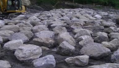
3 Source area Landslide Transportation part Channel erosion Deposition zone Affected (fan)area 3
4 1,673 Torrents Feedback 47,830 People Hardware Potential debris flow torrents Delineation of affected areas Inventory of protected targets Engineering 1. Prevent vulnerability factors 2. Mass energy transformation 3. Diversion 4. Suppression works 5. Restrain works Assessment Land use restrictions Delimitation Announcement Restriction Where? How big (far)? Software Residential Relocation Evacuation Location Coordination Relocation Debris Flow Disaster Management Framework Planning Drill Promotion When? Warning Evacuation Disaster analysis Zoning Rainfall-based Warning system Rainfall > Threshold Feedback Disaster Info. 4
5 1st Debris Flow Event Eastern Taiwan: Hoping village,

 Debris")


6 Typhoon Saola Invaded Taiwan during Aug. 1-3, 2012 Hourly rainfall(mm/hr) Debris flows occurred at 4 am on Aug. 2, R=718 mm; I=120 mm/hr Debris flow warning at 11 pm on Aug. 1 Accumulated Rainfall (mm) 6


7 3 Debris Flow Events in Hoping Village, Hualien County Hualien-DF026 Hualien-DF166 7


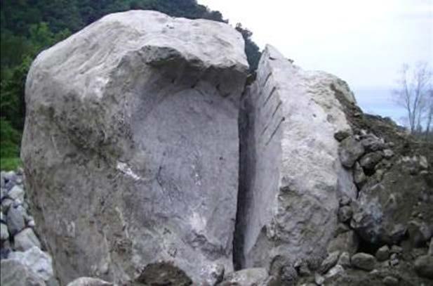
8 Disasters of Hualien DF-166 Potential Debris Flow Torrent Geology: marble, gneiss, shallow topsoil with many folds and joints. There used to be mining industry. Channel length: 2.88 km ;Slope: 10 degrees; Catchment area: ha Over 70,000 cubic meters of sediments were transported to the downstream area and buried 80 houses. The channel was broaden from 5 m to 70 m in width due to strong erosive effect. 8
 is over 200 years.")

9 Causes of Debris Flows Intense rainfall The debris flow occurred at 4 am on Aug. 2 with R=718 mm; I=120 mm/hr. The return period of 12hr-rainfall (567mm/12hr) is over 200 years. A lot of existing debris materials scattered in the upstream areas of the catchment. The channel was blocked by a mound of sediments and giant boulders at the mild portion. The communities are located at the low-lying land and even lower than the potential debris flow torrent. 9


10 Reconstruction Works after Debris Flow Disasters Check dam Sedimentation pond Protecting embankment Channel dredging Debris flow simulation using FLO-2D 10
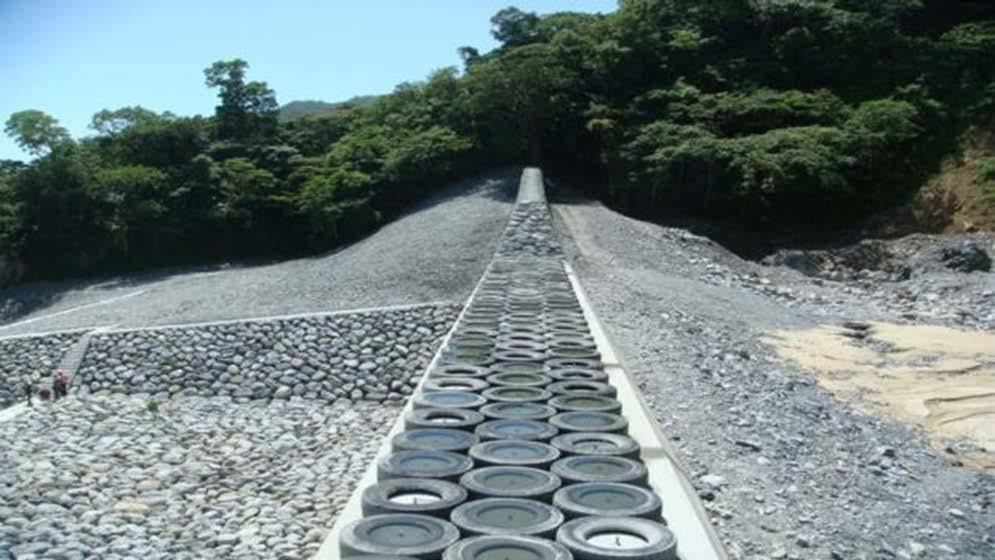
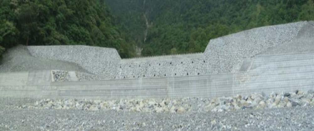
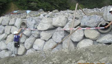
11 Engineering Features 11
12 2nd Debris Flow Event Central Taiwan: Touken torrent,

13 Debris flow caused by torrential rain in Touken torrent on June 11, 2012 Location: Touken torrent (Nantou DF-202) Shenmu village, Nantou County Geology: shale, sandstone and siltstone Channel length: 3.85 km Average slope: 15 degrees Catchment area: 447 ha The debris flow destroyed 3 houses and 10m roads Slit dam Fan area 13
 Debris flow warning at 5 pm, June 10 Debris flow, 7 pm,")
 Fan(natural dam) length: 300 m")
14 Hourly rainfall (mm/hr) Soil and Water Conservation Bureau (SWCB) Debris flow warning at 5 pm, June 10 Debris flow, 7 pm, June 11, R=435mm; I=18.5mm/hr Accumulated Rainfall (mm) Fan(natural dam) length: 300 m width: 150 m depth: 5 m volume: 225,000 m3 14


15 Dammed lake in 2009 by typhoon Morakot Dammed lake in 2012 by torrential rainfall
16 3rd Debris Flow Event Central Taiwan: Shenmu Village,

17 Shenmu Debris Flow Monitoring Station, Nantou County Aiyuzih creek (Nantou DF-226) Geology: weathered shale and sedimentary rock channel length: 3.81 Km Average slope: 14 degrees Drainage area: 410 ha 17


 1996")
18 Landslide Changing from Aerial Images (Upstream area of Aiyuzih creek)

19 seismometer geophone Soil and Water Conservation Bureau (SWCB) Debris Flows Observation Data Torrential rain in Shenmu monitoring station, May 20, 2014 Seismic signals are about 4 min ahead of geophone signals Geophone initiated at 12:53:43 Wires broke at 12:53:44 Upstream, I=54 mm/hr, R=58.5 mm Downstream, I=24.5 mm/hr, R=26 mm Front surge velocity = 4.9 m/s spectrum 19
20 Conclusions 1. Due to the extreme weather conditions, we are facing more and more sediment-related disasters recently in Taiwan as well as other countries in the world. 2. A reliable early warning system ( mostly rainfall-based) is crucial for the evacuation operation. Besides, the warning criteria should be revised regularly according to the feedback of new debris flow events and on-site debris flow monitoring data. 3. Not only debris flows, but shallow, deep-seated landslides and landslide dam problems should be also considered in order to mitigate the possible disasters due to climate change impact in the future. 20


21 Thank You for Your Attention Soil and Water Conservation Bureau Always Working with You 21
Non-structural Countermeasures against Debris Flow Disaster in Taiwan
 Non-structural Countermeasures against Debris Flow Disaster in Taiwan Wang,Chin-Lun Ph.D, Deputy Director General Soil and Water Conservation Bureau Council of Agriculture, Executive Yuan, Taiwan August
Understanding disaster risk ~ Lessons from 2009 Typhoon Morakot, Southern Taiwan
 Understanding disaster risk ~ Lessons from 2009 Typhoon Morakot, Southern Taiwan Wen Chi Lai, Chjeng-Lun Shieh Disaster Prevention Research Center, National Cheng-Kung University 1. Introduction 08/10
A Numerical Method for Determine the Dredging Requirements for Channel Restoration Using Alishan Creek in Central Taiwan as an Example
 A Numerical Method for Determine the Dredging Requirements for Channel Restoration Using Alishan Creek in Central Taiwan as an Example Instructors : Dr. Jie-Dar Cheng Dr. Honglay Chen Dr. Chao-Yuan Lin
Using Weather and Climate Information for Landslide Prevention and Mitigation
 Using Weather and Climate Information for Landslide Prevention and Mitigation Professor Roy C. Sidle Disaster Prevention Research Institute Kyoto University, Japan International Workshop on Climate and
INTRODUCTION. Climate
 INTRODUCTION Climate Landslides are serious natural disasters in many parts of the world. Since the past 30 years, rainfall triggered landslides and debris flows had been one of the natural disasters of
THE CASE STUDY OF DEBRIS FLOW hazard CAUSED BY TYPHOON MORAKOT IN TAIWAN, 2009
 DOI: 10.4408/IJEGE.2011-03.B-076 THE CASE STUDY OF DEBRIS FLOW hazard CAUSED BY TYPHOON MORAKOT IN TAIWAN, 2009 Meei-Ling LIN (*), Kuo-Lung WANG (*), Tien-Chien CHEN (**) & Shen-Chi LIN (***) (*) Department
Landslide Disaster Management in Sri Lanka and Nichola Oya as a Case study. Group 16 Gamini Jayathissa Udeni Nawagamuwa
 Landslide Disaster Management in Sri Lanka and Nichola Oya as a Case study Group 16 Gamini Jayathissa Udeni Nawagamuwa Taiwan Sri lanka >2582 mm, max >5000mm NE= Nov. to Feb 1750 2500 mm >2500 mm Central
EFFECT OF TWO SUCCESIVE CHECK DAMS ON DEBRIS FLOW DEPOSITION
 DOI: 10.4408/IJEGE.2011-03.B-116 EFFECT OF TWO SUCCESIVE CHECK DAMS ON DEBRIS FLOW DEPOSITION Farouk Maricar (*), Haruyuki Hashimoto (*), Shinya Ikematsu (*) & Tomohiro Miyoshi (*) (*) Department of Civil
EIT-Japan Symposium 2011 on Human Security Engineering
 EIT-Japan Symposium 2011 on Human Security Engineering 2011 Disastrous Landslides at Khao Panom, Krabi, Thailand Suttisak Soralump Geotechnical Engineering Research and Development Center (GERD) Faculty
Disaster Risk Reduction and
 6 th ICRM Symposium 2015 Disaster Risk Reduction and 2015/04/23 Resilience in Taipei Outline Natural Disaster and Loss in Taiwan Climate Change and Geohazard Hazard Alert & App Monitoring & Modeling Land
APPLICATION TO PAST DISASTERS OF A METHOD OF SETTING THE RANGE OF DEBRIS FLOW DAMAGE TO HOUSES
 APPLICATION TO PAST DISASTERS OF A METHOD OF SETTING THE RANGE OF DEBRIS FLOW DAMAGE TO HOUSES Hideaki MIZUNO Senior Researcher Erosion and Sediment Control National Institute for Land and Infrastructure
Bias correction of Dynamic Downscaled Typhoons Rainfall Data for Hydrological Applications
 Bias correction of Dynamic Downscaled Typhoons Rainfall Data for Hydrological Applications National Science and Technology Center for Disaster Reduction Dr. Yuan-Fong Su 27 May 2015 2015 International
The Comprehensive Slope-land Disaster Magnitude Assessment for Landslide and Debris Flow
 The Comprehensive Slope-land Disaster Magnitude Assessment for Landslide and Debris Flow Tingyeh WU *, Che-Hsin LIU, Yu-Ting WANG, Yu-Ching LIN, and Chih-Hsin CHANG National Science and Technology Center
CASE STUDY #9 - Brushy Fork Dam, Sugar Grove, West Virginia
 CASE STUDY #9 - Brushy Fork Dam, Sugar Grove, West Virginia Brushy Fork Dam is a flood control structure built by the Soil Conservation Service southeast of the city of Franklin in Pendleton County, West
GIS Application in Landslide Hazard Analysis An Example from the Shihmen Reservoir Catchment Area in Northern Taiwan
 GIS Application in Landslide Hazard Analysis An Example from the Shihmen Reservoir Catchment Area in Northern Taiwan Chyi-Tyi Lee Institute of Applied Geology, National Central University, No.300, Jungda
Flash flood disaster in Bayangol district, Ulaanbaatar
 Flash flood disaster in Bayangol district, Ulaanbaatar Advanced Training Workshop on Reservoir Sedimentation Management 10-16 October 2007. IRTCES, Beijing China Janchivdorj.L, Institute of Geoecology,MAS
Natural Terrain Risk Management in Hong Kong
 Natural Terrain Risk Management in Hong Kong Nick Koor Senior Lecturer in Engineering Geology School of Earth and Environmental Sciences Slope failures in Hong Kong Man-made Slope Failure - 300 landslides
Internationales Symposion INTERPRAEVENT 2004 RIVA / TRIENT
 APPLICATION TO PAST DISASTERS OF A METHOD OF SETTING APPLICATION THE RANGE TO OF PAST DEBRIS DISASTERS FLOW OF DAMAGE A METHOD TO HOUSES OF SETTING THE RANGE OF DEBRIS FLOW DAMAGE TO HOUSES Hideaki Mizuno
THE DEVELOPMENT AND APPLICATION OF THE DISPATCH MODEL FOR MOBILE DEBRIS FLOW MONITORING STATION AT TYPHOON EVENT
 THE DEVELOPMENT AND APPLICATION OF THE DISPATCH MODEL FOR MOBILE DEBRIS FLOW MONITORING STATION AT TYPHOON EVENT Chao-Hsien Yeh 1*, Bing-Jean Lin 2, Yao-Min Fang 3, Hsian-Yuan Yin 4, Hua-wei Lu 5 ABSTRACT
Interpretive Map Series 24
 Oregon Department of Geology and Mineral Industries Interpretive Map Series 24 Geologic Hazards, and Hazard Maps, and Future Damage Estimates for Six Counties in the Mid/Southern Willamette Valley Including
Improvement of Hazard Assessment and Management in the Philippines
 Improvement of Hazard Assessment and Management in the Philippines (2014 Summer Training Course for Slope Land Disaster Reduction) Ian Alejandrino (Philippines) Nguyen Manh Hieu (Vietnam) Presentation
Natural hazards in Glenorchy Summary Report May 2010
 Natural hazards in Glenorchy Summary Report May 2010 Contents Glenorchy s hazardscape Environment setting Flood hazard Earthquakes and seismic hazards Hazards Mass movement Summary Glossary Introduction
The Application of Sabo Technology for Lahars Flood Mitigation and Warning System in Volcanic Area. Agus Sumaryono Bambang Sukatja F.
 The Application of Sabo Technology for Lahars Flood Mitigation and Warning System in Volcanic Area Agus Sumaryono Bambang Sukatja F. Tata Yunita BACKGROUND The Indonesia Government has constructed several
GENERAL. CHAPTER 1 BACKGROUND AND PURPOSE OF THE GUIDELINES Background of the Guidelines Purpose of the Guidelines...
 GENERAL CHAPTER 1 BACKGROUND AND PURPOSE OF THE GUIDELINES... 1 1.1 Background of the Guidelines... 1 1.2 Purpose of the Guidelines... 3 CHAPTER 2 APPLICATION OF THE GUIDELINES... 3 2.1 Potential Users
GUIDELINES FOR CONSTRUCTION TECHNOLOGY TRANSFER DEVELOPMENT OF WARNING AND EVACUATION SYSTEM AGAINST SEDIMENT DISASTERS IN DEVELOPING COUNTRIES
 GUIDELINES FOR CONSTRUCTION TECHNOLOGY TRANSFER DEVELOPMENT OF WARNING AND EVACUATION SYSTEM AGAINST SEDIMENT DISASTERS IN DEVELOPING COUNTRIES MARCH 2004 Ministry of Land, Infrastructure and Transport
International Symposium on Natural Disaster Mitigation. Local vulnerability assessment of landslides and debris flows
 International Symposium on Natural Disaster Mitigation of landslides and debris flows Lessons learnt from Cam Pha town and Van Don district, Quang Ninh province, Vietnam Nguyen Quoc Phi Faculty of Environment
Gully erosion and associated risks in the Tutova basin Moldavian Plateau
 Landform Analysis, Vol. 17: 193 197 (2011) Gully erosion and associated risks in the Tutova basin Moldavian Plateau University Alexandru Ioan Cuza of Iasi, Department of Geography, Romania, e-mail: catiul@yahoo.com
Debris flow hazard mapping with a random walk model in Korea
 Risk Analysis VII PI-627 Debris flow hazard mapping with a random walk model in Korea H.-J. Youn, C.-W. Lee & C.-S. Woo Korea Forest Research Institute, Korea Abstract Recently, the sediment-related disasters,
Sediment Disasters and Mass Movement (SD&M 2 ) NATIONAL DISASTER MANAGEMENT RESEARCH INSTITUTE
 NATIONAL DISASTER MANAGEMENT RESEARCH INSTITUTE") Sediment Disasters and Mass Movement (SD&M 2 ) Contents Outline of SD&M 2 Major outcomes Issues and conclusions Prologue Mass movement in Ulsan, Korea by Typhoon CHABA on Oct. 5. Outline of SD&M 2 Activities
Sediment Disasters and Mass Movement (SD&M 2 ) Contents Outline of SD&M 2 Major outcomes Issues and conclusions Prologue Mass movement in Ulsan, Korea by Typhoon CHABA on Oct. 5. Outline of SD&M 2 Activities
Experimental Study on Effect of Houses on Debris-Flow Flooding and Deposition in Debris Flow Fan Areas
 DATA ACQUISITION AND MODELLING (MONITORING, PROCESSES, TECHNOLOGIES, MODELS) Experimental Study on Effect of Houses on Debris-Flow Flooding and Deposition in Debris Flow Fan Areas Kana Nakatani, Dr. 1
9/23/2013. Introduction CHAPTER 7 SLOPE PROCESSES, LANDSLIDES, AND SUBSIDENCE. Case History: La Conchita Landslide
 Introduction CHAPTER 7 SLOPE PROCESSES, LANDSLIDES, AND SUBSIDENCE Landslide and other ground failures posting substantial damage and loss of life In U.S., average 25 50 deaths; damage more than $3.5 billion
9/13/2011 CHAPTER 9 AND SUBSIDENCE. Case History: La Conchita Landslide. Introduction
 CHAPTER 9 SLOPE PROCESSES, LANDSLIDES, AND SUBSIDENCE Case History: La Conchita Landslide La Conchita: small coastal community 80 km (50 mi) northwest of Los Angeles Landslide occurred on January 10, 2005
Term Knowledge Using and applying Grade Criteria Autumn 1 Assessment window October Natural hazards pose major risks to people and property.
 Assessment Schedule Year 9 2015/6 Term Knowledge Using and applying Grade Criteria Autumn 1 Assessment window October 2015 3.1.1.2 Tectonic Natural hazards pose major risks to people and property. Definition
Progress Report. Flood Hazard Mapping in Thailand
 Progress Report Flood Hazard Mapping in Thailand Prepared By: Mr. PAITOON NAKTAE Chief of Safety Standard sub-beuro Disaster Prevention beuro Department of Disaster Prevention and Mitigation THAILAND E-mail:
The sketch map of field investigations in Wenchuan earthquake hit region, Chengdu City.
 The sketch map of field investigations in Wenchuan earthquake hit region, Chengdu City. 1 Environmental and Geological Condition 1.1 Geomorphology BaiSha River Basin is located in Dujiangyan County, and
Rapid Hazard Assessment of Heavy Rainfall Triggered Landslide Dams A Review
 Rapid Hazard Assessment of Heavy Rainfall Triggered Landslide Dams A Review Focus on the developed technologies in Taiwan J. J. Dong Graduate Institute of Applied Geology, National Central University,
CLIMATE RESILIENT ALTITUDINAL GRADIENTS (CRAGs)
") CLIMATE RESILIENT ALTITUDINAL GRADIENTS (CRAGs) BUILDING CLIMATE CHANGE RESILIENCE IN THE KIVU- RUSIZI WATERSHEDS Great Lake Conference Entebbe 2017 Chris Magero WHAT ARE CRAGs? Climate-Resilient Altitudinal
CLIMATE RESILIENT ALTITUDINAL GRADIENTS (CRAGs) BUILDING CLIMATE CHANGE RESILIENCE IN THE KIVU- RUSIZI WATERSHEDS Great Lake Conference Entebbe 2017 Chris Magero WHAT ARE CRAGs? Climate-Resilient Altitudinal
ENGINEERING HYDROLOGY
 ENGINEERING HYDROLOGY Prof. Rajesh Bhagat Asst. Professor Civil Engineering Department Yeshwantrao Chavan College Of Engineering Nagpur B. E. (Civil Engg.) M. Tech. (Enviro. Engg.) GCOE, Amravati VNIT,
Debris flow: categories, characteristics, hazard assessment, mitigation measures. Hariklia D. SKILODIMOU, George D. BATHRELLOS
 Debris flow: categories, characteristics, hazard assessment, mitigation measures Hariklia D. SKILODIMOU, George D. BATHRELLOS Natural hazards: physical phenomena, active in geological time capable of producing
Dan Miller + Kelly Burnett, Kelly Christiansen, Sharon Clarke, Lee Benda. GOAL Predict Channel Characteristics in Space and Time
 Broad-Scale Models Dan Miller + Kelly Burnett, Kelly Christiansen, Sharon Clarke, Lee Benda GOAL Predict Channel Characteristics in Space and Time Assess Potential for Fish Use and Productivity Assess
Report. Developing a course component on disaster management
 Report Developing a course component on disaster management By Chira Prangkio Tawee Chaipimonplin Department of Geography, Faculty of Social Sciences, Chiang Mai University Thailand Presented at Indian
Grant 0299-NEP: Water Resources Project Preparatory Facility
 Document Produced under Grant Project Number: 45206 May 2016 Grant 0299-NEP: Water Resources Project Preparatory Facility Final Report Volume 3 East Rapti (1 of 9) Prepared by Pvt. Ltd. For Ministry of
Debris Avalanches. Debris avalanche deposits on a volcano in Chile. All of the area in the foreground is buried by a thick debris avalanche.
 Debris Avalanches Volcanoes are not very stable structures. From time to time, they collapse producing large rock and ash avalanches that travel at high speeds down valleys. Collapse maybe caused by an
Deep-Seated Landslides and Landslide Dams Characteristics Caused by Typhoon Talas at Kii Peninsula, Japan
 Deep-Seated Landslides and Landslide Dams Characteristics Caused by Typhoon Talas at Kii Peninsula, Japan Hefryan Sukma KHARISMALATRI*,1, Hitomi KIKUCHI 1, Yoshiharu ISHIKAWA 1, Takashi GOMI 1, Katsushige
Mass Wasting. Mass Wasting. Earth s s External Processes
 1 Mass Wasting Presentation Modified from Instructor Resource Center on CD-ROM, Foundations of Earth Science, 4 th Edition, Lutgens & Tarbuck Mass Wasting 2 Down-slope movement of rock, loose material
Roles of NGII in successful disaster management
 The Second UN-GGIM-AP Plenary Meeting Roles of NGII in successful disaster management Republic of Korea Teheran Iran 28 October 2013 Sanghoon Lee, Ph.D. NGII Outline Type of Disasters Occur in Korea Practical
Regional Flash Flood Guidance and Early Warning System
 WMO Training for Trainers Workshop on Integrated approach to flash flood and flood risk management 24-28 October 2010 Kathmandu, Nepal Regional Flash Flood Guidance and Early Warning System Dr. W. E. Grabs
Cattaraugus Creek: A Story of Flowing Water and the Geology of the Channel It Flows Through Presentation to West Valley Citizen Task Force 4/27/16
 Cattaraugus Creek: A Story of Flowing Water and the Geology of the Channel It Flows Through Presentation to West Valley Citizen Task Force 4/27/16 Raymond C. Vaughan, Ph.D. What happens if you drop a
LOG OF FEWS_TAIWAN IN MORAKOT -TOWARD RELIABLE PRIDICTION OF A EXTREME RAINFALL EVENT
 LOG OF FEWS_TAIWAN IN MORAKOT -TOWARD RELIABLE PRIDICTION OF A EXTREME RAINFALL EVENT Che-Hao Chang National Taipei University of Technology Department of Civil Engineering Taiwan GEOGRAPHICAL ENVIRONMENT
Debris Flow in the Kitamatasawa Tributary of the Namekawa River in the Kiso River System
 Monitoring Note Debris Flow in the Kitamatasawa Tributary of the Namekawa River in the Kiso River System Toshiharu ARISAWA 1 and Yutaka SUZUKI 2 1 Tajimi Office of Sabo and National Highwey,Chubu Regional
USING 3D GIS TO ASSESS ENVIRONMENTAL FLOOD HAZARDS IN MINA
 King Fahd University of Petroleum & Minerals College of Environmental Design Geographical Information system USING 3D GIS TO ASSESS ENVIRONMENTAL FLOOD HAZARDS IN MINA Prepared by : Ali AL-Zahrani OUTLINE
1. INTRODUCTION. EXAMPLE OF SECHILIENNE ROCKFALL (France)
") FORM OSE POST-GRADUATE COURSE Landslide vulnerability and risk 1 FORM OSE POST-GRADUATE COURSE Landslide vulnerability and risk 2 FORM OSE POST-GRADUATE COURSE Landslide vulnerability and risk 3 Christophe
FORM OSE POST-GRADUATE COURSE Landslide vulnerability and risk 1 FORM OSE POST-GRADUATE COURSE Landslide vulnerability and risk 2 FORM OSE POST-GRADUATE COURSE Landslide vulnerability and risk 3 Christophe
Fukien Secondary School Monthly Vocabulary/Expression List for EMI Subjects Secondary Two. Subject: Geography
 Focus: General Specific : Section Two : Unit One 1 Landslide 2 Downslope movement 3 Rock 4 Soil 5 Gravity 6 Natural hazard 7 Rainwater 8 Friction 9 Hilly relief 10 Unstable 11 Season 12 Saturated 13 Construction
CHARACTERISTICS OF RAIN INFILTRATION IN SOIL LAYERS ON THE HILLSLOPE BEHIND IMPORTANT CULTURAL ASSET
 International Journal of GEOMATE, June, 216, Vol. 1, Issue 22, pp.219-2115 Geotec., Const. Mat. & Env., ISSN: 2186-2982(Print), 2186-299(Online), Japan CHARACTERISTICS OF RAIN INFILTRATION IN SOIL LAYERS
8 Current Issues and Research on Sediment Movement in the River Catchments of Japan
 8 Current Issues and Research on Sediment Movement in the River Catchments of Japan YUTAKA ICHIKAWA INTRODUCTION Prediction of sediment movement is one of the challenging tasks in water-related research.
WATERCOURSE HARNESSING BANK EROSION AND CONSOLIDATION
 GUVERNUL MINISTERUL POSDRU MUNCII, FAMILIEI ŞI WATERCOURSE HARNESSING BANK EROSION AND CONSOLIDATION PhD. student: ALUPOAE Daniel Gheorghe Asachi Technical University of Iasi, Faculty of Civil Engineering
Erosion Surface Water. moving, transporting, and depositing sediment.
 + Erosion Surface Water moving, transporting, and depositing sediment. + Surface Water 2 Water from rainfall can hit Earth s surface and do a number of things: Slowly soak into the ground: Infiltration
Prediction of landslide-induced debris flow hydrograph: the Atsumari debris flow disaster in Japan
 Monitoring, Simulation, Prevention and Remediation of Dense and Debris Flows 27 Prediction of landslide-induced debris flow hydrograph: the Atsumari debris flow disaster in Japan H. Takaoka 1, H. Hashimoto
UGRC 144 Science and Technology in Our Lives/Geohazards
 UGRC 144 Science and Technology in Our Lives/Geohazards Flood and Flood Hazards Dr. Patrick Asamoah Sakyi Department of Earth Science, UG, Legon College of Education School of Continuing and Distance Education
Caribbean Early Warning System Workshop
 Caribbean Early Warning System Workshop Hamonization in Existing EWS April 14-16, 2016 Presenter: Shawn Boyce Caribbean Institute for Meteorology and Hydrology Husbands, St. James Barbados Background Between
3/8/17. #20 - Landslides: Mitigation and Case Histories. Questions for Thought. Questions for Thought
 #20 - Landslides: Mitigation and Case Histories Web Exercise #3 (Volcanoes) Due Wednesday There is a 2-point penalty for every day the assignment is late. Exam 1 Scores Scores and exam key are posted Vaiont
THE DISCUSS ON THE SEDIMENT DISASTERS CAUSED REASON IN HAOCHA TRIBE AREA
 THE DISCUSS ON THE SEDIMENT DISASTERS CAUSED REASON IN HAOCHA TRIBE AREA Chun-Li Hsu 1, Shin-Yi Dai 2 * ABSTRACT From 2005 to 2008 series of typhoons and heavy rainfall makes Haocha tribe suffered serious
FLO-2D Simulation of Mudflow Caused by Large Landslide Due to Extremely Heavy Rainfall in Southeastern Taiwan during Typhoon Morakot
 FLO-2D Simulation of Mudflow Caused by Large Landslide Due to Extremely Heavy Rainfall in Southeastern Taiwan during Typhoon Morakot PENG Szu-Hsien 1*, LU Shih-Chung 1 Department of Spatial Design, Chienkuo
SPECIFIC DEGRADATION AND RESERVOIR SEDIMENTATION. By Renee Vandermause & Chun-Yao Yang
 SPECIFIC DEGRADATION AND RESERVOIR SEDIMENTATION By Renee Vandermause & Chun-Yao Yang Outline Sediment Degradation - Erosion vs Sediment Yield - Sediment Yield - Methods for estimation - Defining Sediment
CHALLENGES ON SEDIMENT- RELATED DISASTER MITIGATION
 CHALLENGES ON SEDIMENT- RELATED DISASTER MITIGATION Dolores M. Hipolito Project Manager II DPWH, PMO-FCSEC Types of Sediment-Related Disasters A. Direct Disaster Debris flows Landslides Slope failures
1. Base your answer to the following question on the map below, which shows the generalized bedrock of a part of western New York State.
 1. Base your answer to the following question on the map below, which shows the generalized bedrock of a part of western New York State. 3. The table below describes the deposits that an observer saw while
Multi Hazard Evaluation of a High Voltage Transmission Network. John Eidinger 1 and Leon Kempner 2
 Multi Hazard Evaluation of a High Voltage Transmission Network John Eidinger 1 and Leon Kempner 2 1 G&E Engineering Systems Inc., P. O. Box 3592 Olympic Valley, CA 96146-3592; eidinger@earthlink.net. 2
Evaluation of Flash flood Events Using NWP Model and Remotely Sensed Rainfall Estimates
 Evaluation of Flash flood Events Using NWP Model and Remotely Sensed Rainfall Estimates Dr. Ismail Yucel METU Civil Engineering Department and Fatih Keskin State Hydraulic Works HydroPredict 2010 Prague
2018 Geography Mock Examination
 2018 Geography Mock Examination Your Geography mock examination will test your understanding of Paper 1 (Living with the physical environment) and Section B (Fieldwork) from Paper 2. Attached are the necessary
Landslide & Coastal Erosion Risk Reduction at Oregon s Water/Wastewater Networks
 Landslide & Coastal Erosion Risk Reduction at Oregon s Water/Wastewater Networks Laura Gabel, RG (with Bill Burns, RG & Jonathan Allan, Ph. D) Oregon Department of Geology and Mineral Industries (541)
U-Shaped Sediment Traps
 U-Shaped Sediment Traps SEDIMENT CONTROL TECHNIQUE Type 1 System Sheet Flow Sandy Soils Type 2 System Concentrated Flow Clayey Soils [1] Type 3 System Supplementary Trap Dispersive Soils [1] Generally
2014 Summer training course for slope land disaster reduction Taipei, Taiwan, Aug
 MINISTRY OF SCIENCE AND TECHNOLOGY HYDROTECH RESEARCH INSTITUTE MINISTRY OF NATURAL RESOURCES AND ENVIRONMENT VIETNAM INSTITUTE OF GEOSCIENCES AND MINERAL RESOURCES (VIGMR) 2014 Summer training course
Modeling Great Britain s Flood Defenses. Flood Defense in Great Britain. By Dr. Yizhong Qu
 Modeling Great Britain s Flood Defenses AIRCurrents Editor s note: AIR launched its Inland Flood Model for Great Britain in December 2008. The hazard module captures the physical processes of rainfall-runoff
Need of Proper Development in Hilly Urban Areas to Avoid
 Need of Proper Development in Hilly Urban Areas to Avoid Landslide Hazard Dr. Arvind Phukan, P.E. Cosultant/Former Professor of Civil Engineering University of Alaska, Anchorage, USA RI District Governor
A SIMPLE GIS METHOD FOR OBTAINING FLOODED AREAS
 A SIMPLE GIS METHOD FOR OBTAINING FLOODED AREAS ROMAN P., I. 1, OROS C., R. 2 ABSTRACT. A simple GIS method for obtaining flooded areas. This paper presents a method for obtaining flooded areas near to
Name: Which rock layers appear to be most resistant to weathering? A) A, C, and E B) B and D
 A, C, and E B) B and D") Name: 1) The formation of soil is primarily the result of A) stream deposition and runoff B) precipitation and wind erosion C) stream erosion and mass movement D) weathering and biological activity 2)
Name: 1) The formation of soil is primarily the result of A) stream deposition and runoff B) precipitation and wind erosion C) stream erosion and mass movement D) weathering and biological activity 2)
Oregon APA Legal Issues Workshop December 7, Tricia Sears, DLCD With information from Bill Burns, DOGAMI
 Oregon APA Legal Issues Workshop December 7, 2018 Tricia Sears, DLCD With information from Bill Burns, DOGAMI How this Topic Arrived WE FREQUENTLY HEAR CONCERNS ABOUT LIABILITY AND TAKINGS. Current federal
Science of Natural Disasters: RIVERS& FLOODS! 27 April 2016
 Science of Natural Disasters: RIVERS& FLOODS! 27 April 2016 Rebecca Clotts Department of Geology, University of St Thomas Flood in St Paul, 2014, Star Tribune 1 2 What is a watershed? 3 4 5 6 7 What is
SESSION 6: FLUVIAL LANDFORMS
 SESSION 6: FLUVIAL LANDFORMS KEY CONCEPTS: Fluvial Landforms Management of River Catchment Areas Slope Elements X-PLANATION: FLUVIAL LANDFORMS Rivers form landforms as they erode the landscape. These landforms
Vulnerability mapping for sustainable hazard mitigation in the city of Bukavu, South Kivu DRCongo
 IAG/AIG REGIONAL CONFERENCE, 18th to 22nd Feb. 2011 Vulnerability mapping for sustainable hazard mitigation in the city of Bukavu, South Kivu DRCongo Sadiki Ndyanabo 1, Ine Vandecasteele 2, Jan Moeyersons
Hui Hsuan Yang, Su Ying Chen, Sung Ying Chien, and Wei Sen Li
 NCDR 102-T28 Forensic Investigation of Typhoon Morakot Disaster: Nansalu and Daniao Village Case Study Hui Hsuan Yang, Su Ying Chen, Sung Ying Chien, and Wei Sen Li 2014.05 Contents CONTENTS... I TABLES....
The Effects of Hydraulic Structures on Streams Prone to Bank Erosion in an Intense Flood Event: A Case Study from Eastern Hokkaido
 Symposium Proceedings of the INTERPRAENENT 2018 in the Pacific Rim The Effects of Hydraulic Structures on Streams Prone to Bank Erosion in an Intense Flood Event: A Case Study from Eastern Hokkaido Daisuke
Landslide Hazard Assessment Methodologies in Romania
 A Scientific Network for Earthquake, Landslide and Flood Hazard Prevention SciNet NatHazPrev Landslide Hazard Assessment Methodologies in Romania In the literature the terms of susceptibility and landslide
Bawakaraeng Urgent Sediment Control Project
 Departmen Permukiman Umum Direktorat Jenderal Sumber Daya Air Bawakaraeng Urgent Sediment Control Project (The Most Urgent Components) August 2005 1 The Collapse On March 26, 2004, Mt. Sorongan (EL.2,541m)
Vulnerability assessment of Sta.Rosa-Silang subwatershed using SWAT
 Vulnerability assessment of Sta.Rosa-Silang subwatershed using SWAT Damasa B. Magcale-Macandog, Charles Gunay and Milben A. Bragais Institute of Biological Sciences, University of the Philippines Los Baños,
TABLE OF CONTENTS LIST OF TABLES. Page
 TABLE OF CONTENTS Page 11.0 EFFECTS OF THE ENVIRONMENT ON THE PROJECT... 11-1 11.1 Weather Conditions... 11-1 11.2 Flooding... 11-2 11.3 Forest Fires... 11-2 11.4 Permafrost and Subsidence Risk... 11-3
Rebuilding Flood-Conscious Society
 A zone where strong flood flow or river bank erosion by levee breach are anticipated, which likely to occur collapsing/washing away of house. Set up the joint councils by relative stakeholders(river managers,
Statistical Seismic Landslide Hazard Analysis: an Example from Taiwan
 Statistical Seismic Landslide Hazard Analysis: an Example from Taiwan Chyi-Tyi Lee Graduate Institute of Applied Geology, National Central University, Taiwan Seismology Forum 27: Natural Hazards and Surface
VULNERABILITY OF WATER SUPPLY TO NATURAL HAZARDS IN JAMAICA
 VULNERABILITY OF WATER SUPPLY TO NATURAL HAZARDS IN JAMAICA RAFI AHMAD rafi.ahmad@uwimona.edu.jm Unit for disaster studies, Department of Geography & Geology, The University of the West Indies, Mona Kingston
Geo-hazard Potential Mapping Using GIS and Artificial Intelligence
 Geo-hazard Potential Mapping Using GIS and Artificial Intelligence Theoretical Background and Uses Case from Namibia Andreas Knobloch 1, Dr Andreas Barth 1, Ellen Dickmayer 1, Israel Hasheela 2, Andreas
Working with Natural Stream Systems
 Working with Natural Stream Systems Graydon Dutcher Delaware County Soil & Water Conservation District Stream Corridor Management Program Tropical Storm Sandy October 29,2012 What is a Watershed?
3/3/2013. The hydro cycle water returns from the sea. All "toilet to tap." Introduction to Environmental Geology, 5e
 Introduction to Environmental Geology, 5e Running Water: summary in haiku form Edward A. Keller Chapter 9 Rivers and Flooding Lecture Presentation prepared by X. Mara Chen, Salisbury University The hydro
What Are Disasters? The Rescue Kids Trio!
 The Rescue Kids Trio! What Are Disasters? This manual was made possible through funding by the Council of Local Authorities for International Relations. Disasters and emergency preparedness Emergency preparedness
Figure 1. Which part of the river is labelled in Figure 1? a) Mouth b) Source c) Lower course d) channel
 Mouth b) Source c) Lower course d) channel") Rivers 1. Study Figure 1 showing the long profile of a river Figure 1 A Which part of the river is labelled in Figure 1? a) Mouth b) Source c) Lower course d) channel (1 mark) 2. Complete the sentences
Rivers 1. Study Figure 1 showing the long profile of a river Figure 1 A Which part of the river is labelled in Figure 1? a) Mouth b) Source c) Lower course d) channel (1 mark) 2. Complete the sentences
9. GEOLOGY, SOILS, AND MINERALS
 June 28, 2018 Page 9-1 9. GEOLOGY, SOILS, AND MINERALS This EIR chapter describes the existing geological, soil, and mineral conditions in the planning area. The chapter includes the regulatory framework
Name. 4. The diagram below shows a soil profile formed in an area of granite bedrock. Four different soil horizons, A, B, C, and D, are shown.
 Name 1. In the cross section of the hill shown below, which rock units are probably most resistant to weathering? 4. The diagram below shows a soil profile formed in an area of granite bedrock. Four different
DEBRIS FLOW MONITORING AND WARNING SYSTEMS: A NEW STUDY SITE IN THE ALPS
 DEBRIS FLOW MONITORING AND WARNING SYSTEMS: A NEW STUDY SITE IN THE ALPS Comiti F 1, Macconi P 2, Marchi L 3, Arattano M 4, Borga M 5, Brardinoni F 6, Cavalli M 3, D Agostino V 5, Hellweger S 3, Trevisani
Hazard Resilience Index (HRI) Earthquakes, Tsunamis, and Volcanoes
 Earthquakes, Tsunamis, and Volcanoes") Hazard Index (HRI) Earthquakes, Tsunamis, and Volcanoes Earthquakes Tsunamis Volcano-Ash Falls, Projectiles and Lateral Blasts, Pyroclastic Flows and Lava Flows Earthquakes, Tsunamis and Volcanoes Please
Hazard Index (HRI) Earthquakes, Tsunamis, and Volcanoes Earthquakes Tsunamis Volcano-Ash Falls, Projectiles and Lateral Blasts, Pyroclastic Flows and Lava Flows Earthquakes, Tsunamis and Volcanoes Please
Use of Geospatial data for disaster managements
 Use of Geospatial data for disaster managements Source: http://alertsystemsgroup.com Instructor : Professor Dr. Yuji Murayama Teaching Assistant : Manjula Ranagalage What is GIS? A powerful set of tools
Nipigon River Landslide, Ontario, Canada
 Nipigon River Landslide, Ontario, Canada A. Abdelaziz, S. Besner, R. Boger, B. Fu, J. Deng, and A. Farina Presenter: Jian Deng, Ph.D, P.Eng Centre of Excellence for Sustainable Mining and Exploration,