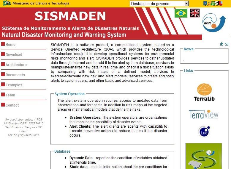
A Natural Disaster Monitoring and Warning System SISMADEN
|
|
|
- Sheryl Willis
- 6 years ago
- Views:
Transcription
1 ABCC Program Workshop Ottawa, September 2010 A Natural Disaster Monitoring and Warning System SISMADEN Dr. Laércio M. Namikawa Eymar S.S. Lopes
2 rincipais Desastres Naturais no Brasil Natural Disasters in Brazil Principais Desastres Naturais no Brasil % 11% 8% 8% 14% 14% 3% 3% 6% 6% 58% 58% Seca Droughts Epidemia Epidemic Temperatura Ext temperature Inundação Floods Deslizamento Landslides High Vendavais winds Epidemia Extreme Temperatura Ex Source (adpated): Vulnerabilidade Ambiental / Rozely Ferreira dos Santos, organizadora. Brasilia: ção MMA, p. : il. color. Deslizamento ; 29 cm. Vendavais

3 Pernambuco and Alagoas


4 Pernambuco and Alagoas June/ deaths 95 municipalities

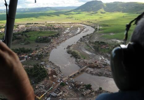
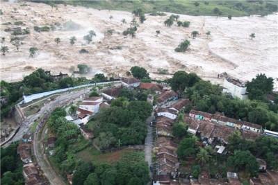
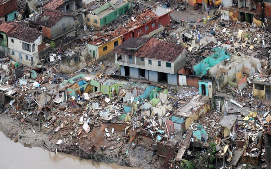
5 Niterói, Rio de Janeiro

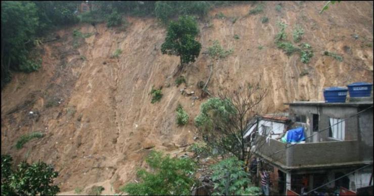


6 Niterói, RJ April/ rio_album.jhtm


7 Niterói, Rio de Janeiro


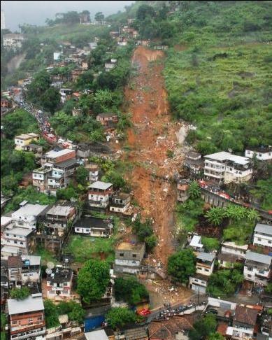
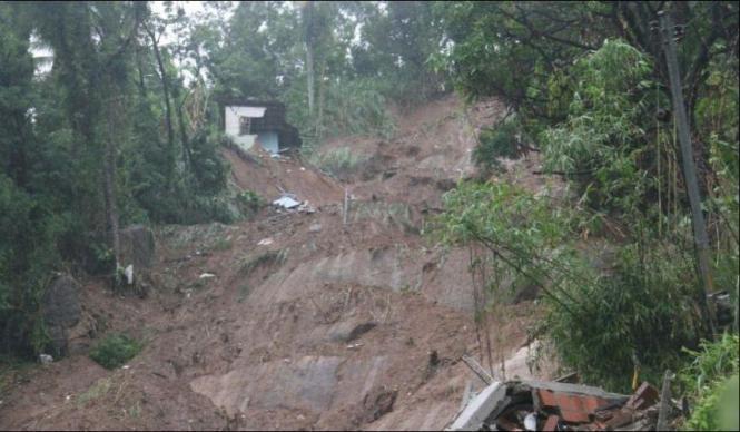
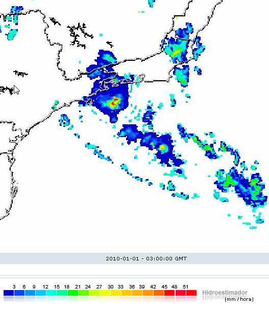
8 Jan/01/2010 Ilha Grande Angra dos Reis Morro da Carioca - Angra dos Reis


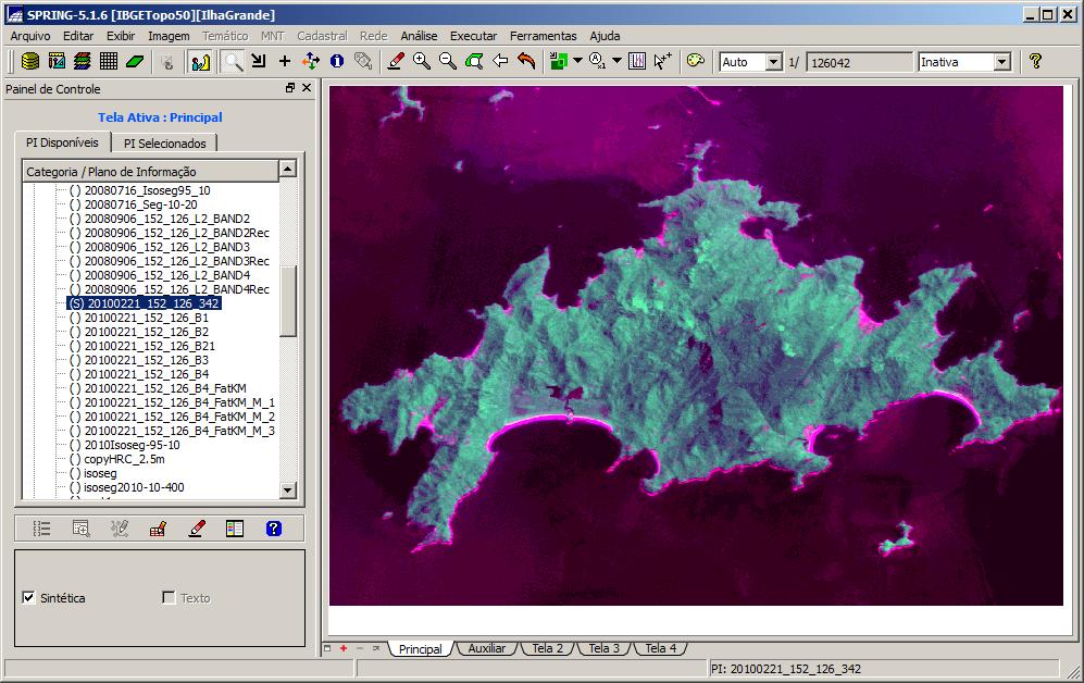
9 CBERS Feb/21/2010
10 Fusion CBERS CCD-HRC
11 Damage Assessment

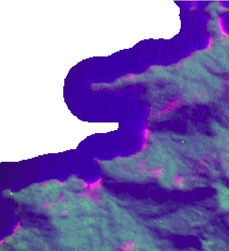

12 Comparison Jul/16/2008 Feb/21/2010
13

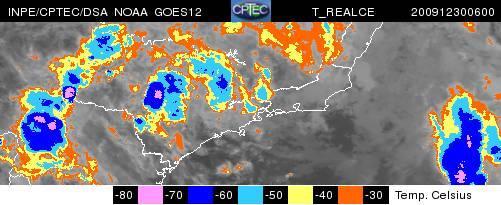
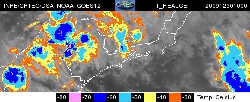
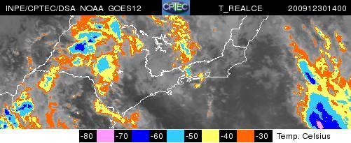
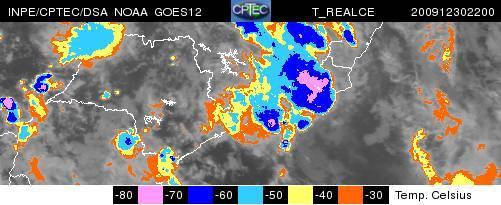
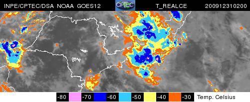
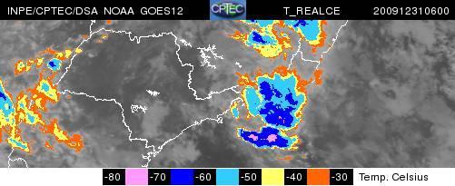
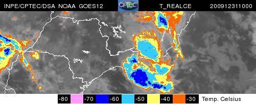
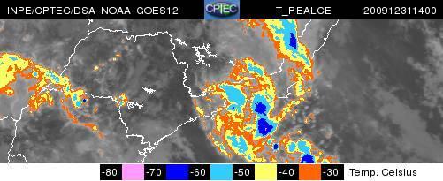
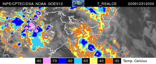
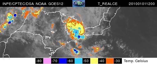
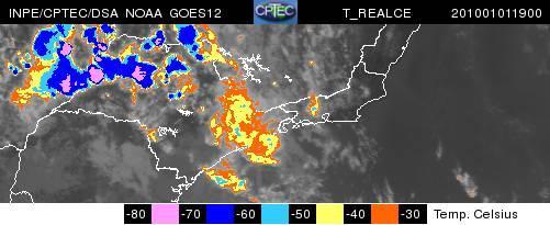
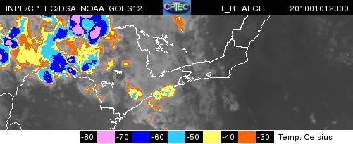
14 GOES Enhanced Image
15
16
17
18
19
20
21
22
23

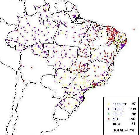
24
25
26
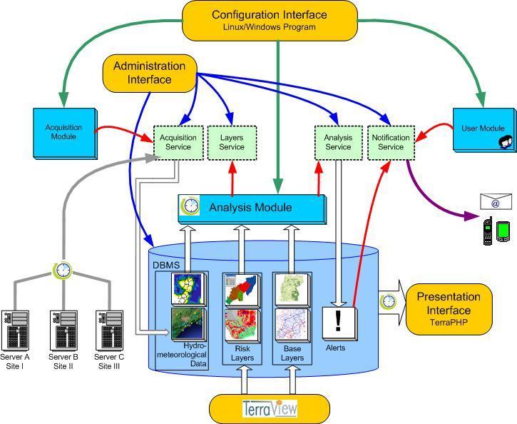
27


28 Center for Weather Forecast and Climate Studies - CPTEC

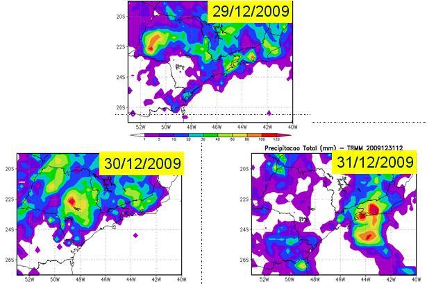
29 Observations by Satellite TRMM Estimated Rain


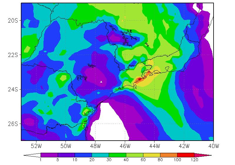
30 Forecast 24h Total Precipitation Run Dec/31/ :00 GMT for 01/Jan/ Eta-20 km
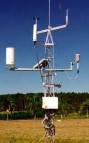


31 Observation Data Collect Platform Weather Radar


32 12/27/ :00:00 12/27/ :00:00 12/27/ :00:00 12/28/ :00:00 12/28/ :00:00 12/28/ :00:00 12/29/ :00:00 12/29/ :00:00 12/29/ :00:00 12/30/ :00:00 12/30/ :00:00 12/30/ :00:00 12/31/ :00:00 12/31/ :00:00 12/31/ :00:00 01/01/ :00:00 01/01/ :00:00 01/01/ :00:00 01/02/ :00:00 01/02/ :00:00 01/02/ :00:00 01/03/ :00:00 Rain Gauge at Angra dos Reis Source: Eletronuclear mm total in 24h 01/01/2009 8: mm total in 24h 31/12/ : mm total in 24h 31/12/2009 9:00 Chuva HourlyHorária Chuva Total in Acum.24h


33 Research and Development in Geoinformatics 1974: I : SITIM and SGI 1991: SPRING : SPRING : SPRING : TerraLib : TerraLib : TerraLib 3.5

34 Technological Support Geographical database and manipulation by TerraLib:
35 Automatically Generated Alerts Hydrology and Meteorology Observations and Forecasts Natural Disaster Risks Risk Areas Extreme Event Spatial Analysis Alerts U s e r s Actions Additional Information

36 Natural Disaster Monitoring and Alert System Open Source Computational System based on service oriented architecture Provides technological infrastructure to develop operational systems to manage alerts of environmental risks Services: Data gathering and formatting Analysis by comparison with risk layers or by executing models Risk model edition for alerts Alert handling and management
37


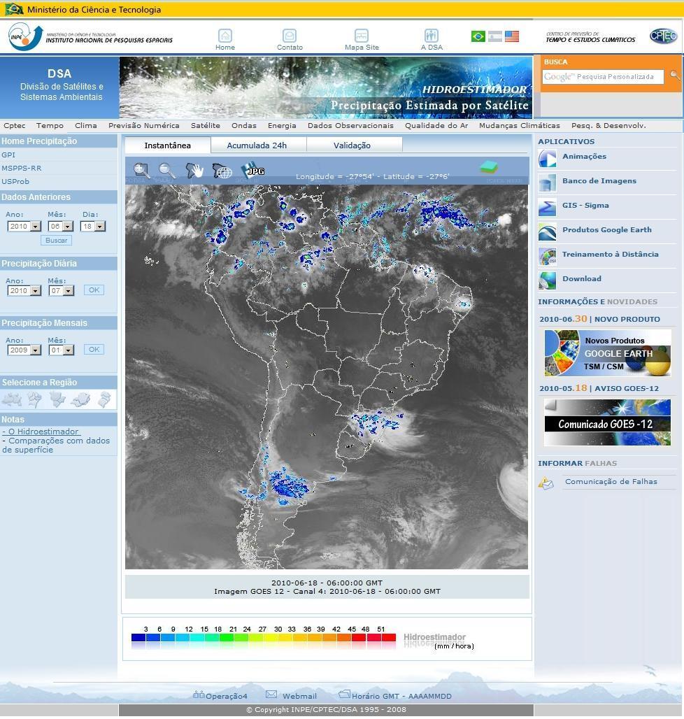
38 Natural Disasters Monitoring and Alert System Who are the users? System Operators Organization that monitor the possibility of disaster events Operate on Administration and Configuration interfaces Insert static data using TerraView

39 Natural Disasters Monitoring and Alert System Who are the users? Alert Clients Representatives with authority to execute prevention and mitigation actions in disaster events Receive alerts in http, , sms

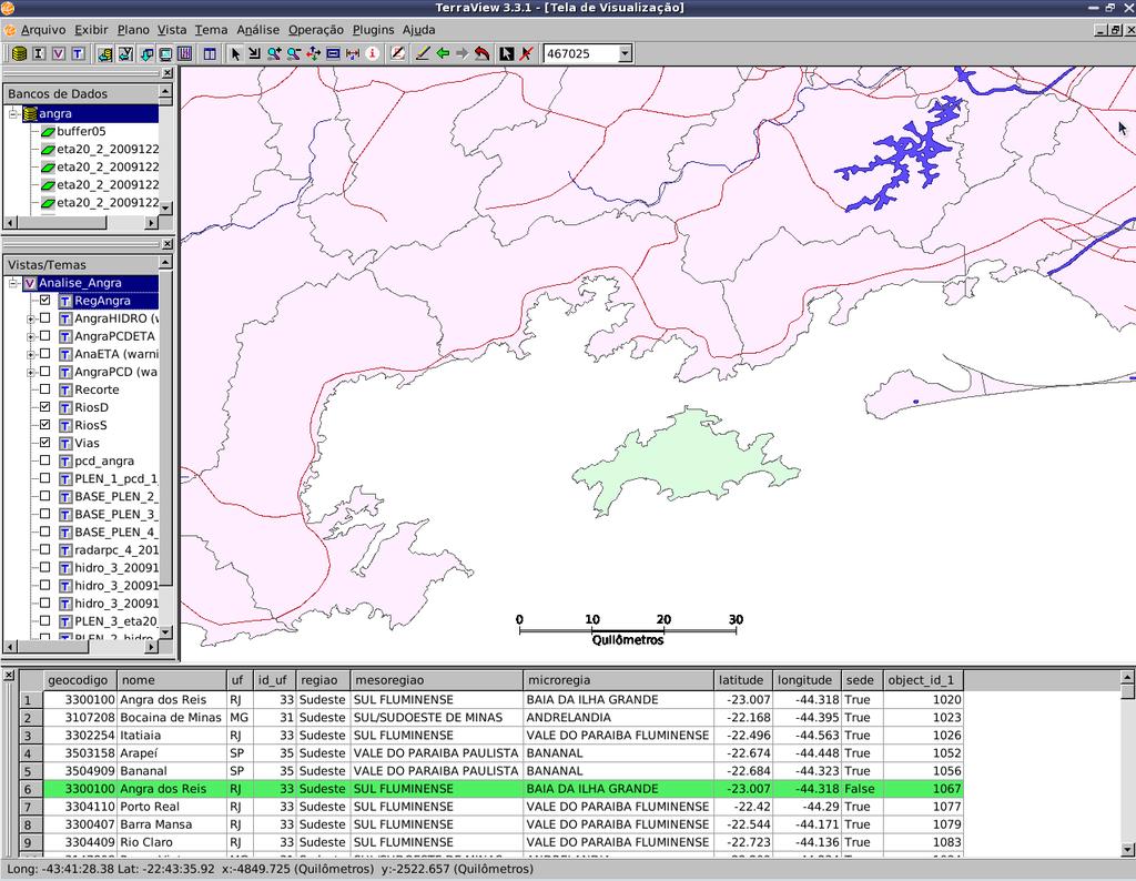
40 WEB Site

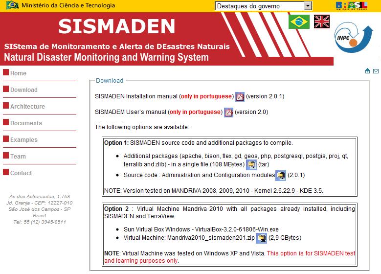
41 Download


42 Ilha Grande January/2010 Hydrology and Meteorology Observations and Forecasts Natural Disaster Risks Risk Areas Municipalities Extreme Event Hydroestimator Spatial Analysis Additional Information Alerts U s e r s Actions

43 Forecast 20x20Km Grid Precipitation 24h

44 Configure Climate Data


45 Hydroestimator on GOES Image Every 15 minutes

46 Configure Risk Map

47 Simple Risk Map Municipalities Inserted using TerraView Polygons Risk Levels

48 Configure Risk Analysis local var1 = media_eta('eta20', 24) if var1 == nil or var1 < 10 then return 0 Normal elseif var1 < 20 then return 1 Observation elseif var1 < 30 then return 2 Attention elseif var1 < 50 then return 3 Alert else return 4 Maximum Alert end
49 Alert Sent by Dear User, There was a change in the Alert Level of one or more regions of the risk map, from one of the analysis you are linked to. See below a complete report of changes: Analysis Name: Analise_Municipios_Hidroestimador Risk Areas ID Name Previous Alert Level Current Alert Level 01 Angra dos Reis Ilha Grande Parati 1 2 IMAGE attached to the report 31/12/ :00 h


50 Warnings 31/12/2009 from 10:00 to 14:00


51 Improving Risk Maps


52 Terrain Morphology

53 Terrain Gradient
54 Land Use Classification

55 Land Use Classification
56 Detailed Risk Map Polygon: Slope Units Where: There is Urban Use and Convex or Plane morphology and Gradient greater than 30 percent
57 Future Developments Inclusion of Dynamic Models - TerraME and TerraHidro (TerraLib family) Call to external models (FORTRAN programs, TITAN2D, Hydrologic models Operators for cumulative rain from observations hydroestimator, radar Data validation - radar, PCD Alert model validation
58 Conclusions Processes extremes captured by risk analyses Includes vulnerabilities Easy programming for non-programmers of input processing and risk analysis


59
Natural Disaster Monitoring and Alert System
 SIStema de Monitoramento e Alerta de DEsastres Naturais Natural Disaster Monitoring and Alert System www.dpi.inpe.br/sismaden Version 1.0 Released July/11/2008 Natural Disasters in Brazil Forest fires
Regional Flash Flood Guidance and Early Warning System
 WMO Training for Trainers Workshop on Integrated approach to flash flood and flood risk management 24-28 October 2010 Kathmandu, Nepal Regional Flash Flood Guidance and Early Warning System Dr. W. E. Grabs
Space for Sustainable Development. Disasters
 Rio+20 - United Nations Conference on Sustainable Development, June 2012 Rio de Janeiro, Brazil Space for Sustainable Development Disasters Carlos AfonsoNobre Carlos FredericoAngelis Why natural disasters
Landslide monitoring system in Iceland. Harpa Grímsdóttir Jón Kristinn Helgason NVE, Oslo, October
 Landslide monitoring system in Iceland Harpa Grímsdóttir Jón Kristinn Helgason NVE, Oslo, October 26 2016 History Avalanches and landslides have caused extensive damages and loss of human lives in Iceland
Workshop on Drought and Extreme Temperatures: Preparedness and Management for Sustainable Agriculture, Forestry and Fishery
 Workshop on Drought and Extreme Temperatures: Preparedness and Management for Sustainable Agriculture, Forestry and Fishery 16-17 Feb.2009, Beijing, China Modeling Apple Tree Bud burst time and frost risk
Caribbean Early Warning System Workshop
 Caribbean Early Warning System Workshop Hamonization in Existing EWS April 14-16, 2016 Presenter: Shawn Boyce Caribbean Institute for Meteorology and Hydrology Husbands, St. James Barbados Background Between
CLIMATE CHANGE ADAPTATION BY MEANS OF PUBLIC PRIVATE PARTNERSHIP TO ESTABLISH EARLY WARNING SYSTEM
 CLIMATE CHANGE ADAPTATION BY MEANS OF PUBLIC PRIVATE PARTNERSHIP TO ESTABLISH EARLY WARNING SYSTEM By: Dr Mamadou Lamine BAH, National Director Direction Nationale de la Meteorologie (DNM), Guinea President,
Instituto de Pesquisas Meteorológicas - IPMet Universidade Estadual Paulista - Unesp
 IPMET WEB GIS APPLICATION FOR SEVERE WEATHER ALERT AND DECISION SUPPORT Jaqueline Murakami Kokitsu Instituto de Pesquisas Meteorológicas - IPMet Universidade Estadual Paulista - Unesp IPMet/Unesp Meteorological
Outline. Research Achievements
 Taiwan Typhoon and Flood Research Institute, National Applied Research Laboratories 11F., No.97, Sec. 1, Roosevelt Rd., Zhongzheng Dist., Taipei City 10093, Taiwan (R.O.C.) http://www.ttfri.narl.org.tw/eng/index.html
GIS in Weather and Society
 GIS in Weather and Society Olga Wilhelmi Institute for the Study of Society and Environment National Center for Atmospheric Research WAS*IS November 8, 2005 Boulder, Colorado Presentation Outline GIS basic
URBAS Prediction and management of flash floods in urban areas
 URBAS Prediction and management of flash floods in urban areas 1 Thomas Einfalt, Klaus Friedeheim, Andreas Wagner Project funded by the Federal Ministry of Education and Research BMBF (Germany) as a part
D DAVID PUBLISHING. Vulnerability to Landslides in the City of Sao Paulo. 1. Introduction. 2. Methodology
 Journal of Civil Engineering and Architecture 10 (2016) 1160-1167 doi: 10.17265/1934-7359/2016.10.007 D DAVID PUBLISHING Vulnerability to Landslides in the City of Sao Paulo Letícia Palazzi Perez 1, 2
12/07/2017. Flash Flood Warning Service, an advanced approach towards flood resilient cities Floodplain Management Association Conference, Newcastle
 12/07/2017 Worldwide problem: Flash Floods Flash Floods are a Global Problem Flash Flood Warning Service, an advanced approach towards flood resilient cities Floodplain Management Association Conference,
Emerging Needs, Challenges and Response Strategy
 Emerging Needs, Challenges and Response Strategy Development of Integrated Observing Systems in China JIAO Meiyan Deputy Administrator China Meteorological Administration September 2011 Geneva Outline
Identification of Areas with Potential for Flooding in South America
 Identification of Areas with Potential for Flooding in South America Sergio Rosim, João Ricardo de Freitas Oliveira, Alexandre Copertino Jardim, Laércio Massaru Namikawa, Cláudia Maria de Almeida Image
Flash Flood Guidance System On-going Enhancements
 Flash Flood Guidance System On-going Enhancements Hydrologic Research Center, USA Technical Developer SAOFFG Steering Committee Meeting 1 10-12 July 2017 Jakarta, INDONESIA Theresa M. Modrick Hansen, PhD
Smart use of Geographic Information System (GIS) platform for delivering weather information and nowcasting services
 platform for delivering weather information and nowcasting services") Smart use of Geographic Information System (GIS) platform for delivering weather information and nowcasting services C. K. Pan Hong Kong Observatory Hong Kong, China It is a world of beauty Source: Image
Smart use of Geographic Information System (GIS) platform for delivering weather information and nowcasting services C. K. Pan Hong Kong Observatory Hong Kong, China It is a world of beauty Source: Image
GI Technology for Disaster Management
 GI Technology for Disaster Management 17 th ICC on the Regional Space Applications Programme for Sustainable Development (RESAP) 26 th Nov 2013 Bangkok Thailand Period and time of seasonal in thailand
Haiti and Dominican Republic Flash Flood Initial Planning Meeting
 Dr Rochelle Graham Climate Scientist Haiti and Dominican Republic Flash Flood Initial Planning Meeting September 7 th to 9 th, 2016 Hydrologic Research Center http://www.hrcwater.org Haiti and Dominican
Group 2: Checking/Verification & Time Series
 Group 2: Checking/Verification & Time Series S.S.B. Brito 1, A. Calheiros 2, A. C. Corsi 3, L.R.L. Rodrigues 2, L.A. Pampuch 4, N. Rubido 5, T. L. Symons 6, and L. Xavier 7 1 CEMADEN, Brazil 2 INPE, Brazil
Keynote Address. Development of Multi-Hazard Early Warning System in Indonesia by Prof. Armi Susandi, PhD
 Keynote Address Development of Multi-Hazard Early Warning System in Indonesia by Prof. Armi Susandi, PhD Professor of Meteorology, Bandung Institute of Technology, Indonesia. Dr. Susandi is an expert in
DRR-related mandates and relevant activities and projects of RA III
 DRR-related mandates and relevant activities and projects of RA III 2015 Meeting of the Disaster Risk Reduction Focal Points of WMO Regional Associations, Technical Commissions and Programmes (DRR FP RA-TC-TP)
MODELLING FROST RISK IN APPLE TREE, IRAN. Mohammad Rahimi
 WMO Regional Seminar on strategic Capacity Development of National Meteorological and Hydrological Services in RA II (Opportunity and Challenges in 21th century) Tashkent, Uzbekistan, 3-4 December 2008
Satellite-based applications for water resources management in Asia and Pacific region
 Satellite-based applications for water resources management in Asia and Pacific region Ko Hamamoto Japan Aerospace Exploration Agency The views expressed in this paper/presentation are the views of the
Geospatial Information and Services for Disasters (GIS4D)
") Geospatial Information and Services for Disasters (GIS4D) 31 July 2017 Tae Hyung KIM ICT and Disaster Risk Reduction Division (IDD) UNESCAP 1 About ESCAP Who is ESCAP? United Nations Economic and Social
Geospatial Information and Services for Disasters (GIS4D) 31 July 2017 Tae Hyung KIM ICT and Disaster Risk Reduction Division (IDD) UNESCAP 1 About ESCAP Who is ESCAP? United Nations Economic and Social
Global Challenges - Partnering with Service Providers. World Meteorological Organization. J. Lengoasa WMO Deputy Secretary-General
 WMO World Meteorological Organization Working together in weather, climate and water Global Challenges - Partnering with Service Providers J. Lengoasa WMO Deputy Secretary-General jlengoasa@wmo.int http://www.wmo.int/pages/gfcs/gfcs_en.html
Overview and purposes of the meeting
 Overview and purposes of the meeting 1 Flash Floods vs. River Floods Riverine Flooding: is caused by heavy rainfall (and/or snow melt) over long periods e.g., days, leading to rising water levels and flooding
Country Presentation-Nepal
 Country Presentation-Nepal Mt.Everest, Shiva Pd. Nepal, DHM South Asia Drought Monitor Workshop Dhaka Bangladesh 2 th April 215 Overview Brief Climatology Climate activities- DHM PPCR (Pilot Program for
2015 Fall Conditions Report
 2015 Fall Conditions Report Prepared by: Hydrologic Forecast Centre Date: December 21 st, 2015 Table of Contents Table of Figures... ii EXECUTIVE SUMMARY... 1 BACKGROUND... 2 SUMMER AND FALL PRECIPITATION...
Copernicus Overview. Major Emergency Management Conference Athlone 2017
 Copernicus Overview Major Emergency Management Conference Athlone 2017 Copernicus is a European programme implemented by the European Commission. The services address six thematic areas: land, marine,
THE 3D SIMULATION INFORMATION SYSTEM FOR ASSESSING THE FLOODING LOST IN KEELUNG RIVER BASIN
 THE 3D SIMULATION INFORMATION SYSTEM FOR ASSESSING THE FLOODING LOST IN KEELUNG RIVER BASIN Kuo-Chung Wen *, Tsung-Hsing Huang ** * Associate Professor, Chinese Culture University, Taipei **Master, Chinese
FFGS Advances. Initial planning meeting, Nay Pyi Taw, Myanmar February, Eylon Shamir, Ph.D,
 FFGS Advances Initial planning meeting, Nay Pyi Taw, Myanmar 26-28 February, 2018 Eylon Shamir, Ph.D, EShamir@hrcwater.org Hydrologic Research Center San Diego, California FFG System Enhancements The following
Near Real-Time Runoff Estimation Using Spatially Distributed Radar Rainfall Data. Jennifer Hadley 22 April 2003
 Near Real-Time Runoff Estimation Using Spatially Distributed Radar Rainfall Data Jennifer Hadley 22 April 2003 Introduction Water availability has become a major issue in Texas in the last several years,
Integrating Nowcastingwith crisis management and risk prevention in a transnational framework (INCA-CE)
") Integrating Nowcastingwith crisis management and risk prevention in a transnational framework (INCA-CE) Yong Wang ZAMG, Austria This project is implemented through the CENTRAL EUROPE Programme co-financed
Integrating Nowcastingwith crisis management and risk prevention in a transnational framework (INCA-CE) Yong Wang ZAMG, Austria This project is implemented through the CENTRAL EUROPE Programme co-financed
National Public Weather and Warning Services in the Swaziland Meteorological Service Dennis S.Mkhonta /
 National Public Weather and Warning Services in the Swaziland Meteorological Service Dennis S.Mkhonta dennis.mkhonta@gmail.com / dennis@swazimet.gov.sz Introduction Swaziland s geographical position exposes
DEVELOPMENT OF A FORECAST EARLY WARNING SYSTEM ethekwini Municipality, Durban, RSA. Clint Chrystal, Natasha Ramdass, Mlondi Hlongwae
 DEVELOPMENT OF A FORECAST EARLY WARNING SYSTEM ethekwini Municipality, Durban, RSA Clint Chrystal, Natasha Ramdass, Mlondi Hlongwae LOCATION DETAILS AND BOUNDARIES ethekwini Municipal Area = 2297 km 2
Japanese Programs on Space and Water Applications
 Japanese Programs on Space and Water Applications Tamotsu IGARASHI Remote Sensing Technology Center of Japan June 2006 COPUOS 2006 Vienna International Centre Water-related hazards/disasters may occur
Thunderstorm Forecasting and Warnings in the US: Applications to the Veneto Region
 Thunderstorm Forecasting and Warnings in the US: Applications to the Veneto Region Bill Conway Vice President Weather Decision Technologies Norman, Oklahoma, USA Andrea Rossa ARPAV Lead Scientist Centre
of an early warning system
 The benefits and the development of an early warning system In the context of: The Mesoamerican Food Security and Early Warning System Project Angel (Bennett) McCoy Angel.M.Bennett@noaa.gov NOAA/Climate
BARON END-TO-END HYDROLOGICAL MODELING SOLUTION NOW AVAILABLE IN NEW BARON LYNX DISPLAY
 4930 Research Drive Huntsville, AL 35805 (256)-881-8811 www.baronweather.com FOR IMMEDIATE RELEASE BARON END-TO-END HYDROLOGICAL MODELING SOLUTION NOW AVAILABLE IN NEW BARON LYNX DISPLAY Powerful scientific
NATIONAL FRAMEWORK FOR FLOOD DISASTER MANAGEMENT IN INDONESIA. 11 th GEOSS ASIA PASIFIC SYMPOSIUM Kyoto, October 2018
 NATIONAL FRAMEWORK FOR FLOOD DISASTER MANAGEMENT IN INDONESIA 11 th GEOSS ASIA PASIFIC SYMPOSIUM Kyoto, 24-26 October 2018 1 OUTLINE Disasters in Indonesia The Disaster Management Mechanism Current Status
Crisis Management and Natural Disasters Overview of JRC operational or pre-operational activities A. Annunziato, D. Al-Khudhairy
 Papagayo, Costarica 3-4 November 2009 Security Science and The Americas 1 Joint Research Centre (JRC) Crisis Management and Natural Disasters Overview of JRC operational or pre-operational activities A.
By Lillian Ntshwarisang Department of Meteorological Services Phone:
 By Lillian Ntshwarisang Department of Meteorological Services Phone: +267 3612200 Email: lntshwarisang@gov.bw/ lntshwarisang@gmail.com Introduction Mandate of DMS Function of the Department Services to
LAYMAN S REPORT Floods and Fire Risk Assessment and Management
 LAYMAN S REPORT Floods and Fire Risk Assessment and Management FLIRE is 50% co-financed by LIFE + financial instrument of the European Union. Floods and Fire risk assessment and management Project s code
Understanding Weather and Climate Risk. Matthew Perry Sharing an Uncertain World Conference The Geological Society, 13 July 2017
 Understanding Weather and Climate Risk Matthew Perry Sharing an Uncertain World Conference The Geological Society, 13 July 2017 What is risk in a weather and climate context? Hazard: something with the
Measures Also Significant Factors of Flood Disaster Reduction
 Non-Structual Measures Also Significant Factors of Flood Disaster Reduction Babiaková Gabriela, Leškov ková Danica Slovak Hydrometeorological Institute, Bratislava Hydrological Forecasts and Warning Department
Memo. I. Executive Summary. II. ALERT Data Source. III. General System-Wide Reporting Summary. Date: January 26, 2009 To: From: Subject:
 Memo Date: January 26, 2009 To: From: Subject: Kevin Stewart Markus Ritsch 2010 Annual Legacy ALERT Data Analysis Summary Report I. Executive Summary The Urban Drainage and Flood Control District (District)
International Flood Network - IFNet
 International Flood Network - IFNet - Akira Sasaki Deputy Director General IFNet Secretariat Today s s Contents 1. IFNet (International Flood Network) 2. GFAS (Global Flood Alert System) Increasing Flood
World Meteorological Organization
 World Meteorological Organization Opportunities and Challenges for Development of Weather-based Insurance and Derivatives Markets in Developing Countries By Maryam Golnaraghi, Ph.D. Head of WMO Disaster
Disaster Mitigation Competence Centre Project Meeting Coordinator: Simon Lin
 Disaster Mitigation Competence Centre Project Meeting Coordinator: Simon Lin April 26, 2018 Agenda Introduction (Simon Lin) From Previous Meeting on March 17, 2015 (Eric Yen) Progress Report (Eric Yen)
ÖBB Natural Hazard Management
 ÖBB Natural Hazard Management Management of Weather Events in the Austrian Federal Railways MOWE-IT, Brussels 17 th of September 2013 DI Günther Kundela Integrated Track Management Integration Technic
Mapping of Flooding Points and Rainfall Data using ArcGIS Rio de Janeiro City - RJ - Brazil Events
 RIO DE JANEIRO CITY HALL MUNICIPALSECRETARY OF SANITATION AND WATER RESOURCES - SMAR WATER SANITATION AND DRAINAGE AUTHORITY - RIOÁGUAS BOARD OF STUDIES AND PROJECTS MANAGEMENT OF RESEARCH AND TECHNICAL
HEAVY RAIN OVER MID-CENTRAL REGION OF VIETNAM
 HEAVY RAIN OVER MID-CENTRAL REGION OF VIETNAM ----------------------------------------------------------------------- S.Eng. Dang Thi Mai; Dr. Nguyen Thi Tan Thanh National Hydro Meteorological Service
Applications/Users for Improved S2S Forecasts
 Applications/Users for Improved S2S Forecasts Nolan Doesken Colorado Climate Center Colorado State University WSWC Precipitation Forecasting Workshop June 7-9, 2016 San Diego, CA First -- A short background
The National Integrated Drought Information System (NIDIS) Moving the Nation from Reactive to Proactive Drought Risk Management
 Moving the Nation from Reactive to Proactive Drought Risk Management") The National Integrated Drought Information System (NIDIS) Moving the Nation from Reactive to Proactive Drought Risk Management CSG-West Annual Meeting Agriculture & Water Committee Snowbird, UT September
The National Integrated Drought Information System (NIDIS) Moving the Nation from Reactive to Proactive Drought Risk Management CSG-West Annual Meeting Agriculture & Water Committee Snowbird, UT September
Activities and Outlook related to Disaster Reduction in CMA
 Activities and Outlook related to Disaster Reduction in CMA WANG Bangzhong China Meteorological Administration March 15-17 2006 ADENDA Situation about MD and related disasters in CHINA Guidance for MD/RD
TOOLS FOR RISK MANAGEMENT Related to climate change
 TOOLS FOR RISK MANAGEMENT Related to climate change copyright CONTENT 1 CLIMATE CHANGE AND ENVIRONMENTAL STUDIES 2 METHODS AND TOOLS DEVELOPED BY EGIS For infrastructures For urban areas For crisis management
INDONESIA IMPACT BASED FORECAST PROGRAM
 INDONESIA IMPACT BASED FORECAST PROGRAM Seoul, 19-21 November 2018 The 2nd Regional Workshop on Impact-based Forecasts in Asia Indonesia Agency for Meteorology Climatology and Geophysics (BMKG) A. Fachri
Graduate Courses Meteorology / Atmospheric Science UNC Charlotte
 Graduate Courses Meteorology / Atmospheric Science UNC Charlotte In order to inform prospective M.S. Earth Science students as to what graduate-level courses are offered across the broad disciplines of
WMO Public Weather Services: Enhanced Communication Skills for Improved Service Delivery. by S.W. Muchemi (WMO)
") WMO Public Weather Services: Enhanced Communication Skills for Improved Service Delivery by S.W. Muchemi (WMO) Functions of the Public Weather Services (PWS) programme of WMO To strengthen the capabilities
WMO Public Weather Services: Enhanced Communication Skills for Improved Service Delivery by S.W. Muchemi (WMO) Functions of the Public Weather Services (PWS) programme of WMO To strengthen the capabilities
WRF Modeling System Overview
 WRF Modeling System Overview Jimy Dudhia What is WRF? WRF: Weather Research and Forecasting Model Used for both research and operational forecasting It is a supported community model, i.e. a free and shared
Final Report. COMET Partner's Project. University of Texas at San Antonio
 Final Report COMET Partner's Project University: Name of University Researcher Preparing Report: University of Texas at San Antonio Dr. Hongjie Xie National Weather Service Office: Name of National Weather
EARLY WARNING IN SOUTHERN AFRICA:
 EARLY WARNING IN SOUTHERN AFRICA: Enhancing the Meteorological Early Warning System Eugene Poolman South African Weather Service OUTLINE OF PRESENTATION Impact of Climate Change Meteorological Early Warning
Forecast Challenges for the Colorado Basin River Forecast Center
 Forecast Challenges for the Colorado Basin River Forecast Center John Lhotak, Development and Operations Hydrologist Improving Sub-Seasonal to Seasonal (S2S) Workshop May 16th, 2018 1 River Forecast Centers
NASA Flood Monitoring and Mapping Tools
 National Aeronautics and Space Administration ARSET Applied Remote Sensing Training http://arset.gsfc.nasa.gov @NASAARSET NASA Flood Monitoring and Mapping Tools www.nasa.gov Outline Overview of Flood
Renewables and the Smart Grid. Trip Doggett President & CEO Electric Reliability Council of Texas
 Renewables and the Smart Grid Trip Doggett President & CEO Electric Reliability Council of Texas North American Interconnected Grids The ERCOT Region is one of 3 North American grid interconnections. The
Global Flash Flood Guidance System Status and Outlook
 Global Flash Flood Guidance System Status and Outlook HYDROLOGIC RESEARCH CENTER San Diego, CA 92130 http://www.hrcwater.org Initial Planning Meeting on the WMO HydroSOS, Entebbe, Uganda 26-28 September
National Weather Service Flood Forecast Needs: Improved Rainfall Estimates
 National Weather Service Flood Forecast Needs: Improved Rainfall Estimates Weather Forecast Offices Cleveland and Northern Indiana Ohio River Forecast Center Presenter: Sarah Jamison, Service Hydrologist
Agrometeorological activities in RHMSS
 Republic of Serbia Republic Hydrometeorological Service of Serbia Agrometeorological activities in RHMSS Department for applied climatology and agrometeorology www.hidmet.gov.rs Meteorological Observing
Workshop on MCCOE Radar Meteorology /Climatology in Indonesia. Segel Ginting Wanny K. Adidarma
 Workshop on MCCOE Radar Meteorology /Climatology in Indonesia BPPT, 28 Februari 2013 JAKARTA FLOOD EARLY WARNING SYSTEM (J-FEWS) Segel Ginting Wanny K. Adidarma JCP (Joint Cooperation Program) Indonesia
Evaluation of MPE Radar Estimation Using a High Density Rain Gauge Network within a Hydro-Estimator Pixel and Small SubWatershed
 Evaluation of MPE Radar Estimation Using a High Density Rain Gauge Network within a Hydro-Estimator Pixel and Small SubWatershed ALEJANDRA M. ROJAS GONZÁLEZ 1, ERIC W. HARMSEN 2 AND SANDRA CRUZ POL 3 1
Global Flood Alert System based on satellite derived rainfall data -Targeting the era of Global Precipitation Measurement (GPM)-
-") Global Flood Alert System based on satellite derived rainfall data -Targeting the era of Global Precipitation Measurement (GPM)- Riko Oki, Misako Kachi (JAXA/EORC) Kazuhiko Fukami (PWRI) and Kazuo Umeda
Global Flood Alert System based on satellite derived rainfall data -Targeting the era of Global Precipitation Measurement (GPM)- Riko Oki, Misako Kachi (JAXA/EORC) Kazuhiko Fukami (PWRI) and Kazuo Umeda
COUNTRY REPORT. Jakarta. July, th National Directorate of Meteorology and Geophysics of Timor-Leste (DNMG)
") The Southeastern Asia-Oceania Flash Flood COUNTRY REPORT Jakarta. July, 10-12 th 2017 National Directorate of Meteorology and Geophysics of Timor-Leste (DNMG) Carla Feritas and Crisostimo Lobato Democratic
The Southeastern Asia-Oceania Flash Flood COUNTRY REPORT Jakarta. July, 10-12 th 2017 National Directorate of Meteorology and Geophysics of Timor-Leste (DNMG) Carla Feritas and Crisostimo Lobato Democratic
Improving global coastal inundation forecasting WMO Panel, UR2014, London, 2 July 2014
 Improving global coastal inundation forecasting WMO Panel, UR2014, London, 2 July 2014 Cyclone Sidr, November 2007 Hurricane Katrina, 2005 Prof. Kevin Horsburgh Head of marine physics, UK National Oceanography
National Report on Weather Forecasting Service
 MINISTRY OF WATER RESOURCES AND METEOROLOGY DEPARTMENT OF METEOROLOGY, CAMBODIA National Report on Weather Forecasting Service Tokyo, 11-15 March 2014 Department of Meteorology, Cambodia Presentation Outline
European Drought Observatory Progress on Drought Monitoring
 European Drought Observatory Progress on Drought Monitoring Alfred de Jager Diego Magni European Commission Joint Research Centre (JRC) Disaster Risk Management Unit Outline 1. Introduction Philosophy
The Development of the Slope Failure Management System
 FANG Ji, Akiyuki KAWASAKI, Satoru SADOHARA The Development of the Slope Failure Management System There are many incidents of slope failure across Japan. The measures are required. Recently soft-measures
INCA CE: Integrating Nowcasting with crisis management and risk prevention in a transnational framework
 INCA CE: Integrating Nowcasting with crisis management and risk prevention in a transnational framework Yong Wang ZAMG, Austria This project is implemented through the CENTRAL EUROPE Programme co-financed
Complete Weather Intelligence for Public Safety from DTN
 Complete Weather Intelligence for Public Safety from DTN September 2017 White Paper www.dtn.com / 1.800.610.0777 From flooding to tornados to severe winter storms, the threats to public safety from weather-related
VULNERABILITY TO FLOODING IN THE CITY OF SAO PAULO
 VULNERABILITY TO FLOODING IN THE CITY OF SAO PAULO L. Palazzi 1&2 and J.R.S.Martins 1&2 1. Research in the MAPLU Project, at the University of Sao Paulo 2. Polytechnic School, University of São Paulo ABSTRACT:
DETECTION AND FORECASTING - THE CZECH EXPERIENCE
 1 STORM RAINFALL DETECTION AND FORECASTING - THE CZECH EXPERIENCE J. Danhelka * Czech Hydrometeorological Institute, Prague, Czech Republic Abstract Contribution presents the state of the art of operational
ROLE OF INDIA METEOROLOGICAL DEPARTMENT IN MANAGEMENT OF METEOROLOGICAL HAZARDS IN INDIA M MOHAPATRA
 ROLE OF INDIA METEOROLOGICAL DEPARTMENT IN MANAGEMENT OF METEOROLOGICAL HAZARDS IN INDIA M MOHAPATRA INDIA METEOROLOGICAL DEPARTMENT NEW DELHI-110003 mohapatraimd@gmail.com Introduction Presentation layout
REQUIREMENTS FOR WEATHER RADAR DATA. Review of the current and likely future hydrological requirements for Weather Radar data
 WORLD METEOROLOGICAL ORGANIZATION COMMISSION FOR BASIC SYSTEMS OPEN PROGRAMME AREA GROUP ON INTEGRATED OBSERVING SYSTEMS WORKSHOP ON RADAR DATA EXCHANGE EXETER, UK, 24-26 APRIL 2013 CBS/OPAG-IOS/WxR_EXCHANGE/2.3
WMO/WWRP FDP: INCA CE
 WMO/WWRP FDP: INCA CE Yong Wang ZAMG, Austria This project is implemented through the CENTRAL EUROPE Programme co-financed by the ERDF INCA CE: implementation over Central Europe A Nowcasting Initiative
Catalysing Innovation in Weather Science - the role of observations and NWP in the World Weather Research Programme
 Catalysing Innovation in Weather Science - the role of observations and NWP in the World Weather Research Programme Estelle de Coning, Paolo Ruti, Julia Keller World Weather Research Division The World
US Drought Status. Droughts 1/17/2013. Percent land area affected by Drought across US ( ) Dev Niyogi Associate Professor Dept of Agronomy
 Dev Niyogi Associate Professor Dept of Agronomy") Droughts US Drought Status Dev Niyogi Associate Professor Dept of Agronomy Deptof Earth Atmospheric Planetary Sciences Indiana State Climatologist Purdue University LANDSURFACE.ORG iclimate.org climate@purdue.edu
Droughts US Drought Status Dev Niyogi Associate Professor Dept of Agronomy Deptof Earth Atmospheric Planetary Sciences Indiana State Climatologist Purdue University LANDSURFACE.ORG iclimate.org climate@purdue.edu
Regional EGM on Community of Practice of Georeferenced Information System. for Disaster Risk Management (Geo-DRM) April 2014, Bangkok, Thailand
 April 2014, Bangkok, Thailand") Regional EGM on Community of Practice of Georeferenced Information System for Disaster Risk Management (Geo-DRM) 23-25 April 2014, Bangkok, Thailand Presented By Mukesh Kumar Keshari Ministry of Home Affairs
Regional EGM on Community of Practice of Georeferenced Information System for Disaster Risk Management (Geo-DRM) 23-25 April 2014, Bangkok, Thailand Presented By Mukesh Kumar Keshari Ministry of Home Affairs
ECRA General Assembly 2019
 ECRA General Assembly 2019 Collaborative Programme on High Impact Events and Climate Change (CP-HIE) Martin Drews and Hilppa Gregow Technical University of Denmark & Finnish Meteorological Institute Understanding
GenEd Courses offered by Dept. of Geography, Presidency University
 GenEd Courses offered by Dept. of Geography, Presidency University (All the Courses are offered to both Science and Humanities Students) Semester Course No. Course Name Maximum No. of Students (originally
Early Flood Warning System in Pakistan
 Early Flood Warning System in Pakistan By Muhammad Tahir Anwar Director General M/o National Food Security and Research Government of Pakistan Asian Water Cycle Forum 2016 March 1-2, 2016 Tokyo, Japan
A NOWCASTING SYSTEM USING SATELLITE AND RADAR DATA: THE CHUVA PROJECT EXPERIENCE
 A NOWCASTING SYSTEM USING SATELLITE AND RADAR DATA: THE CHUVA PROJECT EXPERIENCE Luiz Augusto Machado Chuva Science Team CHUVA Project: Cloud processes of the main precipitation 6 systems in Brazil: A
Recent development of the National Hydro-Meteorological Service (NHMS) of Viet Nam for disaster risk reduction
 of Viet Nam for disaster risk reduction") Ministry of Natural Resources and Environment National Hydro-Meteorological Service Recent development of the National Hydro-Meteorological Service (NHMS) of Viet Nam for disaster risk reduction Tran Van
Ministry of Natural Resources and Environment National Hydro-Meteorological Service Recent development of the National Hydro-Meteorological Service (NHMS) of Viet Nam for disaster risk reduction Tran Van
Roles of NGII in successful disaster management
 The Second UN-GGIM-AP Plenary Meeting Roles of NGII in successful disaster management Republic of Korea Teheran Iran 28 October 2013 Sanghoon Lee, Ph.D. NGII Outline Type of Disasters Occur in Korea Practical
Application of Satellite Data for Flood Forecasting and Early Warning in the Mekong River Basin in South-east Asia
 MEKONG RIVER COMMISSION Vientiane, Lao PDR Application of Satellite Data for Flood Forecasting and Early Warning in the Mekong River Basin in South-east Asia 4 th World Water Forum March 2006 Mexico City,
Unit 5: NWS Hazardous Weather Products. Hazardous Weather and Flooding Preparedness
 Unit 5: NWS Hazardous Weather Products Objectives Describe the mission of the NWS Describe the basic organizational structure of the NWS Explain the purpose of various NWS products Explain how Probability
Evaluation of Flash flood Events Using NWP Model and Remotely Sensed Rainfall Estimates
 Evaluation of Flash flood Events Using NWP Model and Remotely Sensed Rainfall Estimates Dr. Ismail Yucel METU Civil Engineering Department and Fatih Keskin State Hydraulic Works HydroPredict 2010 Prague
Gridding of precipitation and air temperature observations in Belgium. Michel Journée Royal Meteorological Institute of Belgium (RMI)
") Gridding of precipitation and air temperature observations in Belgium Michel Journée Royal Meteorological Institute of Belgium (RMI) Gridding of meteorological data A variety of hydrologic, ecological,
Gridding of precipitation and air temperature observations in Belgium Michel Journée Royal Meteorological Institute of Belgium (RMI) Gridding of meteorological data A variety of hydrologic, ecological,
Overview of Early Warning Systems and the role of National Meteorological and Hydrological Services
 Overview of Early Warning Systems and the role of National Meteorological and Hydrological Services South Africa Second Experts Symposium on Multi-Hazard Early Warning Systems With focus on the Role of
SAWIDRA Southern Africa
 SAWIDRA Southern Africa Presenter: Thembani Moitlhobogi Assistant Database and IT Expert SADC Climate Services Centre 13 th EUMETSAT Forum in Africa 24-28 September 2018, Abidjan, Cote d Ivoire Context
KEY ACHIEVEMENTS, LESSON LEARNT AND SUGGESTIONS FOR FUTURE OPPORTUNITIES
 KEY ACHIEVEMENTS, LESSON LEARNT AND SUGGESTIONS FOR FUTURE OPPORTUNITIES The project of Strengthening Multi-Hazard Risk Assessment and Early Warning Systems in Pacific Islands Countries Center for Public