A century of experience: Training and knowledge transfer in Africa 30 years of activities: Past, present and future
|
|
|
- Beatrix McDaniel
- 6 years ago
- Views:
Transcription


1 Royal Museum for central Africa A century of experience: Training and knowledge transfer in Africa 30 years of activities: Past, present and future
2 Earth Sciences Field Geology Geodynamics Major thematics Natural resources (ores, gems, water ) Remote sensing Natural risks (volcanic, seismic, water, climatic) Environmental studies
3 Training activities United Nation Development Program World Bank UNESCO The AU-EU partnership Belgian Federal Cooperation Diverse Institutional cooperations NGOs Private compagnies


4 Mainly with UNESCO Earth Sciences Division - Natural Sciences Sector since 1981
5 Involved in 4 major programmes over the 2 themes Geology for Sustainable Development : African Bibliography Bibliographie Africaine International Mapping Programmes: Geological Application of Remote Sensing / GARS Services contract between UNESCO and MRAC often on +/ co-financing basis.
6 I. Geology for (Sustainable) Development Focus on research and transfer of knowledge (seminars, MSc & PhD; joint fieldwork & research,...) Topic changed over time: basic Precambrian geology Economic geology (mineralized orogens) Urban Geology & Geohazards


7 Deliverables Seminars organised in African universities Zambia 81; Burundi 83; Uganda 84; Rwanda 86; Malawi 86; Tanzania 91 Géotraverses: subcontinent-scale cross-border fieldwork with international group of earth scientists (univ & geol. surv.) Burundi 83; Rwanda 84; Tanzania 85 GIS development: study on economic axis Kinshasa Matadi: RDCongo Newsletters: series of publications of on-going research & activities ( ) vol 1 4: precambrian geology vol 5-9: economic geology vol 10: geo-environment vol 11: urban geology
8 GARS Africa: : R&D; testing new satellite Remote Sensing methodology in Africa (feasability) Test sites Burundi and Tanzania Belgian/French research group with logistic support from african geological surveys 91-94: training & implementation of RS knowhow & facilities 5 geological surveys: Burundi, Ethiopia, Rwanda, Tanzania, Uganda Training 3 earth scientist of each collaborating survey (4 months in Tervuren), 2 months follow-up in field in each country GARS GeoDatabase Management: Training & implementation of GIS know how 6 geological surveys: Botswana, Ethiopia, Rwanda, Swaziland, Tanzania, Uganda training 2 earth scientists of each collaborating survey (6 months Tervuren), 2 months follow-up in field Implementation of GIS systems in each country


9 Belgian Federal cooperation Group trainings in Belgium in Africa Mixed: in Belgium with a follow-up in Africa Institutional collaborations Universities Local administrations Scientific cruises on the Tanganyika Lake


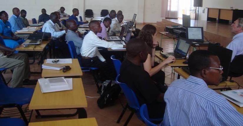
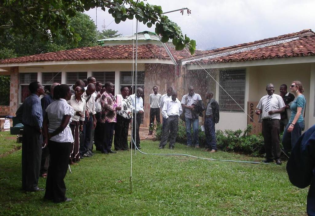
10 Indoor courses in Butare LOCAL GROUP TRAININGS Presentation of new field techniques: rain simulation, Kigali Field trip in Uvira, DRC


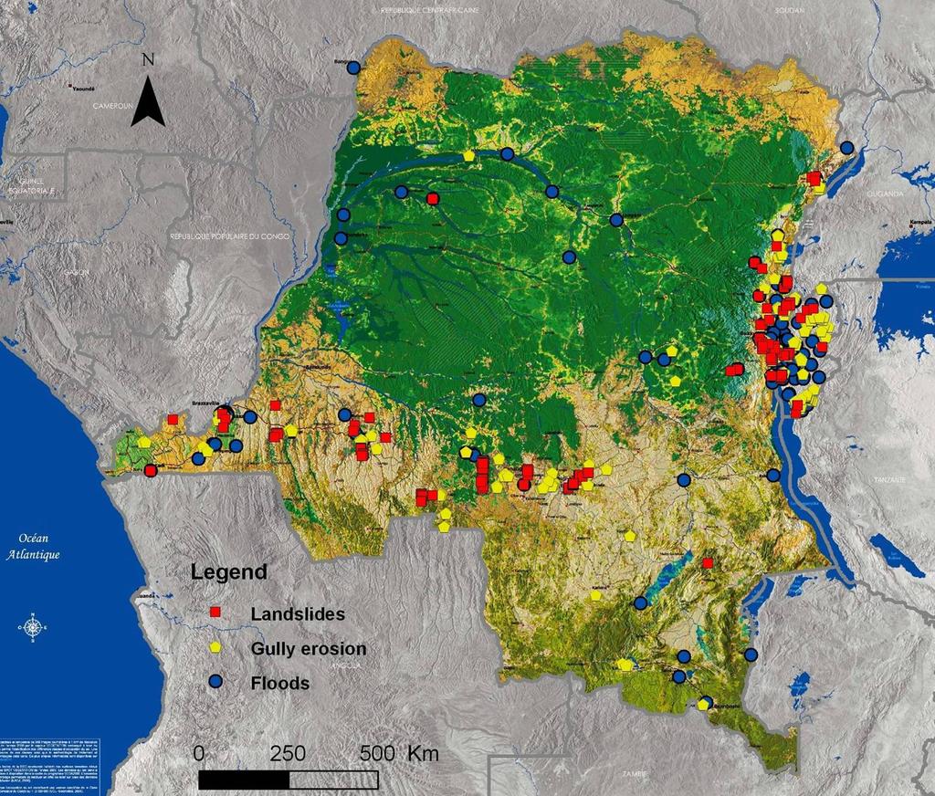
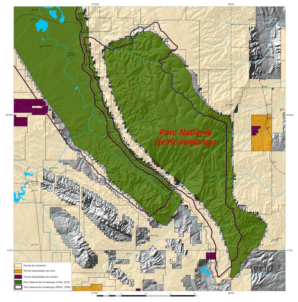
11 The Natural Hazards Database for Central Africa Total annual material damage >> 200 millions EURO and annually hundreds of human victims


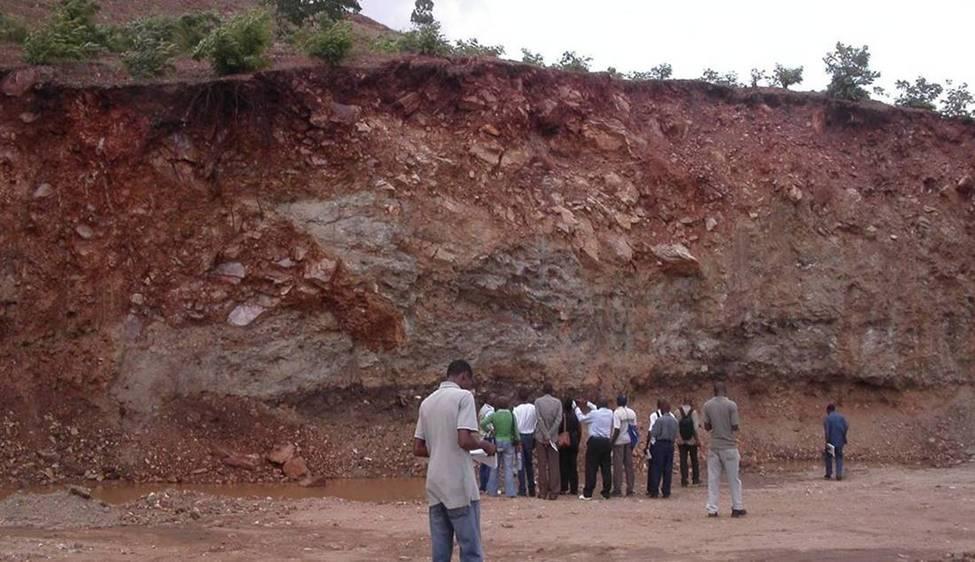
12 s Examples of hillslope incision related disasters in Central Africa: KINSHASA


13 Examples of hillslope incision related disasters in Central Africa 94,5 km length 2 km² of incised surfaces (Monaco!) Gullies in Kinshasa 2007


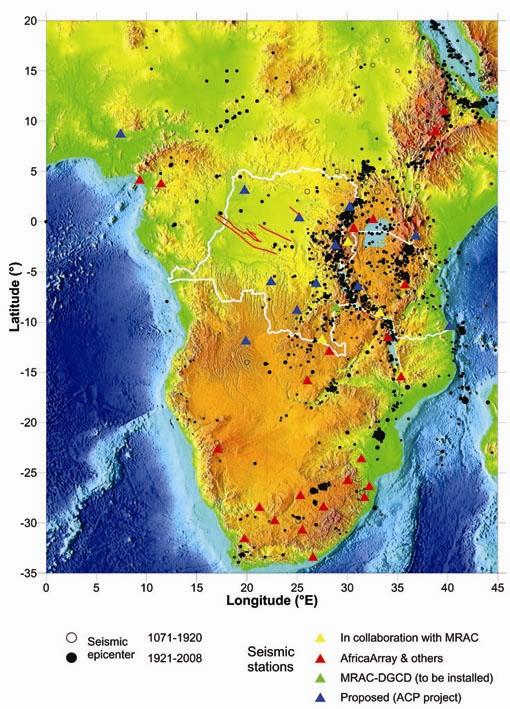
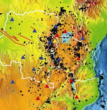
14 AfricaARRAY


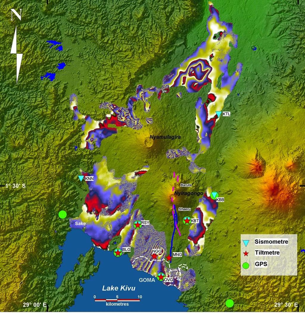
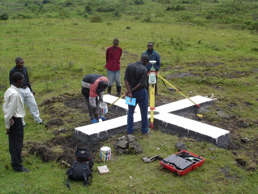
15 Ground Deformation monitoring Deformation modeling Mechanisms Ground based: Lux.


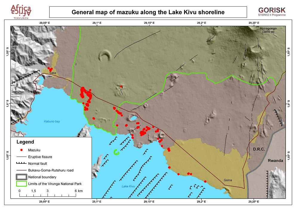
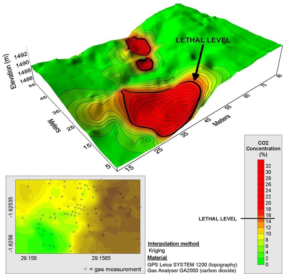
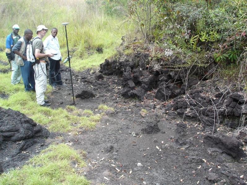
16 CO2 risks


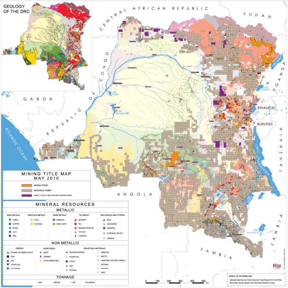

17 The DRC mining polygons The bonanza The permits Gold Diamond Coltan Copper


18 The challenge: Integrate parks within the polygons Parks and MABs The permits Yangambi Luki MAB reserves Lufira


19 Geodesic errors
20 AU-EU Parternship 1.Peace and Security 2.Democratic governance and human rights 3.Trade and regional integration 4.Millenium development goals 5.Energy 6.Climate Change 7.Migration, mobility and development 8.Science, information society and space Science ERAFRICA ( ) Space BRAGMA ( )
21 National S&T co operation programmes Although cooperation is growing among the profiled countries, there is still clearly room for a consolidation and coordination of these efforts. The differences in structures and methods of funding S & T in each of these countries call for a re visioning of cooperation in undertaking a coherent approach to coordinated funding. In thematic areas particularly, a cooperative approach will serve to better address and coordinate funding activities. ERAFRICA is a coordination and support action funded under the European Union FP7 programme Grant agreement no.:


22 Aim, Scope and Implementation of the Programme Approaches ERAFRICA is a coordination and support action funded under the European Union FP7 programme Grant agreement no.: Note: Based on info available in 1.1.
23 Aim, Scope and Implementation of the Programme Approaches The target country approach: Capacity development processes (education of professionals, research towards the sustainable management) Collaboration / knowledge sharing Environment of research Mobility and long term collaboration between researchers Specialised focus Human, management or ICT capacities Poverty alleviation and sustainable social and economic development Agriculture Networking, exchange of knowledge among scientists ERAFRICA is a coordination and support action funded under the European Union FP7 programme Grant agreement no.:
24 GMES and Africa aims at strengthening and building regional and local capabilities to allow African users to access Earth Observation-derived information 9 major thematic issues: from health to border conflicts Natural resources Marine and coastal areas Water resources Climate variability and change Natural disasters Food security & rural development Infrastructure & territorial development Conflicts and political crises Health Management Issues Added values EU EUMETSAT ESA Actually a pan-african perspective assurance of continuity both in space & time a long term perspective: towards services guaranteeing data as defined by needs


")


25 1. Support Coordination and Promote awareness Organising key meetings including a Major Awareness and Coordination Events in Africa Facilitating participation of selected African stakeholders at relevant events 2. In-loco support to entity responsible for implementation of GMES and Africa Action Plan (GAAP) Investing on the connection with the governance Contributing for the sustainability of the initiative Providing in-loco consultation and dissemination Tropical Research Institute
26 BRAGMA ( ) BRidging Actions for GMes and Africa 5 Workshops Theme Country Date IST-Africa 2012 Tanzania 9-11 May 2012 Marine and coastal areas Kenya June 2012 Water Management Nigeria July 2012 Natural resources Egypt September 2012 First evaluation Ethiopia October : Defining the priorities using the GMES instruments >2013: Priorities of a Panafrican program


27 Mining is booming, but some African governments are in danger of squandering the benefits The Artisanal mining A rush on every potentials PROMINES 1 US$ 90M 50M WB / 40M DFID PROMINES 2 Copper 2012 Diamond 2017 Gold PROMINES
28 Promines (US$ million) Increase transparency and accountability in the DRC mining sector so that the income from natural resources will be used for inclusive and sustainable growth. PROMINES 1 US$ 90M 50M WB / 40M DFID PROMINES 2 PROMINES


29 Promines 1: 5 phases Nonrenewable resources EITI Access to resources Monitoring operations Collection of taxes and royalties Revenue management, allocation Efficient, sustainable utilization Inclusive & Sustainable Development Millions USD Terms of Reference RMCA Geo-education Training Knowledge transfer 29


30 Thank you
Artisanal Mining & Biosphere Reserves in Central Africa
 Artisanal Mining & Biosphere Reserves in Central Africa How to contribute from the Earth Sciences perspective Luc André Royal Museum for Central Africa The ASM poverty trap How to alleviate this viscious
UNESCO Earth Science Education Initiative in Africa Initial Activities
 UNESCO Earth Science Education Initiative in Africa Initial Activities S. Felix Toteu 1 and Sarah Gaines 2 1 UNESCO Nairobi Office, Kenya 2 UNESCO Headquarters, Paris In Arusha, Tanzania on 8 May 2008
THE ROLE OF SEAMIC IN SUSTAINABLE MINERAL RESOURCES DEVELOPMENT IN AFRICA
 THE ROLE OF SEAMIC IN SUSTAINABLE MINERAL RESOURCES DEVELOPMENT IN AFRICA Ketema Tadesse Director General-SEAMIC Dar es Salaam, Tanzania August 11, 2009 SEAMIC BACKGROUND SEAMIC was established in 1977
Land Use / Land Cover Mapping in
 Land Use / Land Cover Mapping in Eastern and Southern African Regions RCMRD Experience by 6/24/2013, Nairobi Kenya Dr. Tesfaye Korme Director of RS, GIS and Mapping, RCMRD I. About RCMRD, Its Vision and
African requirements for SDI standardization Antony Cooper Operating Unit Fellow Built Environment CSIR PO Box 395, Pretoria, 0001, South Africa
 ISO/TC 211 workshop on spatial data infrastructures (SDIs) African requirements for SDI standardization Antony Cooper Operating Unit Fellow Built Environment CSIR PO Box 395, Pretoria, 0001, South Africa
COLLABORATIVE RESEARCH ON EAST AFRICA TERRITORY INTEGRATION WITHIN GLOBALISATION
 Presentation by Prof. Bernard Charlery de la Masselière Coordinator CREATING C.R.E.A.T.IN.G. A EU/SSH COORDINATING ACTION COLLABORATIVE RESEARCH ON EAST AFRICA TERRITORY INTEGRATION WITHIN GLOBALISATION
Declaration Population and culture
 Declaration Population and culture The ministers of the parties to the Alpine Convention regard the socio-economic and socio-cultural aspects mentioned in Article 2, Paragraph 2, Item a., as being central
The Development of Trade Transit Corridors in Africa s Landlocked Countries
 The Development of Trade Transit Corridors in Africa s Landlocked Countries I. Introduction Africa has 15 landlocked countries that face specific challenges. Botswana, Burkina Faso, Burundi, Chad, Central
NSDI as a tool for Secure land tenure
 NSDI as a tool for Secure land tenure General Overview To look at the progress in SDI development and its application in policy formulation and impact on land tenure. INTEGRATION OF INFORMATION POLICIES
Launch of the ESPON 2013 Programme. European observation network on territorial development and cohesion
 Launch of the ESPON 2013 Programme European observation network on territorial development and cohesion Framework conditions for the ESPON 2013 Programme Policy development in use of territorial evidence
A contribution to GEOSS from the SDI for Georesources in Africa
 A contribution to GEOSS from the SDI for Georesources in Africa A. TELLEZ-ARENAS BRGM, France in behalf of: Dr. Marc URVOIS Project Coordinator BRGM, France Mineral Resources Division INSPIRE Conference
Jordan's Strategic Research Agenda in cultural heritage
 Jordan's Strategic Research Agenda in cultural heritage Analysis of main results Alessandra Gandini Amman, Jordan 3 rd November 2013 Main objectives The work performed had the main objective of giving
Alps Results from the ESPON Project. Common spatial perspectives for the Alpine area. Towards a common vision
 Results from the ESPON Project Alps 2050 Common spatial perspectives for the Alpine area. Towards a common vision Tobias Chilla, University of Erlangen Cooperation Alps 2020+ 1 & 2 October 2018 Salzburg
Biodiversity and Protected Areas Management Project
 Biodiversity and Protected Areas Management Project Technical Advisor ESA region: Selwyn Willoughby Coordinator ESA region: Christine Mentzel FlexiCadastre EMEA Regional User Conference, Cape Town, South
Current experiences in the use of satellite information in development aid activities
 Current experiences in the use of satellite information in development aid activities Meeting at ESA/ESRIN in Frascati 16 th of September 2017 #WorldInCommon AGENCE FRANÇAISE DE DÉVELOPPEMENT FRENCH DEVELOPMENT
The AMGI project: A Brief Overview
 The AMGI project: A Brief Overview World Bank Group (Energy & Extractives Global Practice) GEEDR Francisco Igualada (figualada@worldbank.org) Presented by Ash Johnson, Geosoft Inc. The AMGI Project: Vision
ATPC ATPC. No. 10. African Trade Policy Centre. Briefing. I. Introduction. The Development of Trade Transit Corridors in Africa s Landlocked Countries
 September 2010 ATPC ATPC Briefing No. 10 African Trade Policy Centre The Development of Trade Transit Corridors in Africa s Landlocked Countries Economic Commission for Africa I. Introduction Africa has
GIS (GEOGRAPHICAL INFORMATION SYSTEMS) AS A FACILITATION TOOL FOR SUSTAINABLE DEVELOPMENT IN AFRICA
 AS A FACILITATION TOOL FOR SUSTAINABLE DEVELOPMENT IN AFRICA") GIS (GEOGRAPHICAL INFORMATION SYSTEMS) AS A FACILITATION TOOL FOR SUSTAINABLE DEVELOPMENT IN AFRICA a presentation by Elizabeth Hicken GDEST Conference on Geospatial Sciences for Sustainable Development
GIS (GEOGRAPHICAL INFORMATION SYSTEMS) AS A FACILITATION TOOL FOR SUSTAINABLE DEVELOPMENT IN AFRICA a presentation by Elizabeth Hicken GDEST Conference on Geospatial Sciences for Sustainable Development
The ESPON Programme. Goals Main Results Future
 The ESPON Programme Goals Main Results Future Structure 1. Goals Objectives and expectations Participation, organisation and networking Themes addressed in the applied research undertaken in ESPON projects
Geological information for Europe : Towards a pan-european Geological Data Infrastructure
 Geological information for Europe : Towards a pan-european Geological Data Infrastructure Integrating geoscientific information for EU competitiveness Co-funded by the European Union European societal
UN-GGIM: Strengthening Geospatial Capability
 Fifth Plenary Meeting of UN-GGIM: Europe Brussels, 6-7 June 2018 UN-GGIM: Strengthening Geospatial Capability Walking the talk to leave no one behind Greg Scott, UN-GGIM Secretariat Environmental Statistics
Implementation of the ESPON 2020 cooperation program. 16 January 2017 Anneloes van Noordt
 Implementation of the ESPON 2020 cooperation program 16 January 2017 Anneloes van Noordt Outline! ESPON Cooperation Program! Specific Objectives! Applied Research! Targeted Analysis! Database & Tools!
Statement. H.E Dr. Richard Nduhuura Permanent Representative of the Republic of Uganda to the United Nations New York
 Page1 UGANDA Permanent Mission of Uganda To the United Nations New York Tel : (212) 949 0110 Fax : (212) 687-4517 Statement By H.E Dr. Richard Nduhuura Permanent Representative of the Republic of Uganda
UNESCO s Earth Science. Education Initiative in Africa. United Nations Educational, Scientific and Cultural Organization
 UNESCO s Earth Science Education Initiative in Africa United Nations Educational, Scientific and Cultural Organization Few milestones First International Conference on African and Arabian Geoparks 2011,
Natura 2000 and spatial planning. Executive summary
 Natura 2000 and spatial planning Executive summary DISCLAIMER The information and views set out in this study are those of the author(s) and do not necessarily reflect the official opinion of the Commission.
CONFERENCE STATEMENT
 CONFERENCE STATEMENT We, the elected representatives from Canada, Denmark/Greenland, Finland, Iceland, Norway, Russia, Sweden and the United States of America; In collaboration with the indigenous peoples
CONFERENCE STATEMENT
 Final draft CONFERENCE STATEMENT We, the elected representatives of Canada, Denmark/Greenland, the European Parliament, Finland, Iceland, Norway, Russia, Sweden and the United States of America; In collaboration
THE SEVILLE STRATEGY ON BIOSPHERE RESERVES
 THE SEVILLE STRATEGY ON BIOSPHERE RESERVES 1 VISION FOR BIOSPHERE RESERVES IN THE 21 ST CENTURY The international Seville Conference on Biosphere Reserves, organised by UNESCO, adopted a two-pronged approach,
ACTION PLAN FOR WORLD HERITAGE IN LATIN AMERICA AND THE CARIBBEAN ( )
") Annex ACTION PLAN FOR WORLD HERITAGE IN LATIN AMERICA AND THE CARIBBEAN (2014-2024) The current Regional Action Plan for Latin America and the Caribbean for 2014-2024 has been elaborated by the State Parties
Annex ACTION PLAN FOR WORLD HERITAGE IN LATIN AMERICA AND THE CARIBBEAN (2014-2024) The current Regional Action Plan for Latin America and the Caribbean for 2014-2024 has been elaborated by the State Parties
What is Spatial Planning?
 Spatial Planning in the context of the Responsible Governance of Tenure What is Spatial Planning? Text-only version This course is funded by the European Union through the EU-FAO Improved Global Governance
Concept note. High-Level Seminar: Accelerating Sustainable Energy for All in Landlocked Developing Countries through Innovative Partnerships
 Concept note High-Level Seminar: Accelerating Sustainable Energy for All in Landlocked Developing Countries through Innovative Partnerships Date: 24 and 25 October 2016 Venue: Conference Room C3, Vienna
Spatially enabling e-government through geo-services
 Spatially enabling e-government through geo-services Mauro Salvemini EUROGI PRESIDENT Professor at Sapienza Università di Roma (IT) 1 About the presentation Few information about Eurogi ; Some essential
Weather Climate Science to Service Partnership South Africa
 PROJECTS UNDERWAY Title of the Weather Climate Science to Service Partnership South Africa Together, building on an existing strong partnership, South African Weather Service and the Met Office will build
COUNCIL OF THE EUROPEAN UNION. Brussels, 2 May /14 CULT 68
 COUNCIL OF THE EUROPEAN UNION Brussels, 2 May 2014 9129/14 CULT 68 NOTE from: General Secretariat of the Council to: Permanent Representatives Committee (Part 1) / Council No. prev. doc.: 8892/14 CULT
Application for Horizon Research and Innovation Framework Programme. ANTHUSIA Anthropology of Human Security in Africa (48 months)
") Application for Horizon 2020 - Research and Innovation Framework Programme ANTHUSIA Anthropology of Human Security in Africa (48 months) 2 Presentation of IARA (Institute for Anthropological Research in
Application for Horizon 2020 - Research and Innovation Framework Programme ANTHUSIA Anthropology of Human Security in Africa (48 months) 2 Presentation of IARA (Institute for Anthropological Research in
National Perspectives - Portugal. Margarida Almodovar
 National Perspectives - Portugal Margarida Almodovar margarida.almodovar@mam.gov.pt from base line to the external limit of the continental shelf behind 200 miles and according to UNCLOS definitions Economic
EuroGeoSurveys & ASGMI The Geological Surveys of Europe and IberoAmerica
 EuroGeoSurveys & ASGMI The Geological Surveys of Europe and IberoAmerica Geological Surveys, what role? Legal mandate for data & information: Research Collection Management Interpretation/transformation
KUNMING FORUM ON UNITED NATIONS GLOBAL GEOSPATIAL INFORMATION MANAGEMENT CITIES OF THE FUTURE: SMART, RESILIENT
 KUNMING FORUM ON UNITED NATIONS GLOBAL GEOSPATIAL INFORMATION MANAGEMENT CITIES OF THE FUTURE: SMART, RESILIENT and SUSTAINABLE Yunnan Zhenzhuang Guest House, Kunming, China 10 12 May 2017 BACKGROUND CONCEPT
SHaSA. Strategy for the Harmonization of Statistics in Africa
 BANQUE AFRICAINE DE DEVELOPPEMENT AFRICAN DEVELOPMENT FUND Strategy for the Harmonization of Statistics in Africa Strategy for the Harmonization of Statistics in Africa 2017-2026 SHaSA Multi-Year Action
REPORT ON ACTIVITIES UNDERTAKEN SINCE THE 25TH SESSION OF THE INTERNATIONAL COORDINATING COUNCIL OF THE MAN & THE BIOSPHERE PROGRAMME
 AFRICAN NETWORK OF BIOSPHERE RESERVES (AFRIMAB) REPORT ON ACTIVITIES UNDERTAKEN SINCE THE 25TH SESSION OF THE INTERNATIONAL COORDINATING COUNCIL OF THE MAN & THE BIOSPHERE PROGRAMME 26 TH MAB ICC SESSION
Future perspectives for EO in Development
 Future perspectives for EO in Development Meeting at ESA/ESRIN in Frascati 11 th of September 2018 #WorldInCommon AGENCE FRANÇAISE DE DÉVELOPPEMENT FRENCH DEVELOPMENT AGENCY 01. What is AFD? France s international
Challenges and Successes in Sharing Geospatial Data in Africa
 Challenges and Successes in Sharing Geospatial Data in Africa 2018 GeoNode Summit Torino, Italy March 26-28, 2018 Bernard Justus Muhwezi Manager, Geo-Information Services Uganda Bureau of Statistics, Kampala,
Spatial Data Infrastructure in the Pacific
 Spatial Data Infrastructure in the Pacific. Sachindra Singh Senior Geospatial Systems Architect ICT for Development, Geoscience Division Pacific Community (SPC) OrganisationalBackground SPC - The Pacific
The Global Statistical Geospatial Framework and the Global Fundamental Geospatial Themes
 The Global Statistical Geospatial Framework and the Global Fundamental Geospatial Themes Sub-regional workshop on integration of administrative data, big data and geospatial information for the compilation
Land Use in the context of sustainable, smart and inclusive growth
 Land Use in the context of sustainable, smart and inclusive growth François Salgé Ministry of sustainable development France facilitator EUROGI vice president AFIGéO board member 1 Introduction e-content+
The Integrated Ge spatial Information Framework to the strengthening of NSDI, Mongolia
 Young Geospatial Professionals Summit 21 NOV 2018 The Integrated Ge spatial Information Framework to the strengthening of NSDI, Mongolia BAYARMAA ENKHTUR Geospatial information and technology department
Activity 6.3 Geoscience information infrastructure and management
 G E O S C I E N T I F I C K N O W L E D G E A N D S K I L L S I N A F R I C A N G E O L O G I C A L S U R V E Y S Activity 6.3 Geoscience information infrastructure and management CAG25 - TW4 Workshop
The National Spatial Strategy
 Purpose of this Consultation Paper This paper seeks the views of a wide range of bodies, interests and members of the public on the issues which the National Spatial Strategy should address. These views
KENYA NATIONAL BUREAU OF STATISTICS Workshop on
 KENYA NATIONAL BUREAU OF STATISTICS Workshop on Capacity Building in Environment Statistics: the Framework for the Development of Environment Statistics (FDES 2013) Coordination with Sector Ministries
RETA 6422: Mainstreaming Environment for Poverty Reduction Category 2 Subproject
 RETA 6422: Mainstreaming Environment for Poverty Reduction Category 2 Subproject A. Basic Data 1. Subproject Title: Poverty-Environment Mapping to Support Decision Making 2. Country Director: Adrian Ruthenberg
EUROPEAN INVESTMENT BANK
 EUROPEAN INVESTMENT BANK RISC Consortium and the UNU-CRIS Summer School/ Students Research Symposium, 3 rd July 2012, Luxembourg Regional Projects good practice? Kamil Dörfler 1 Outline General background
Proposal for a DIRECTIVE OF THE EUROPEAN PARLIAMENT AND OF THE COUNCIL. establishing an infrastructure for spatial information in the Community
 Proposal for a DIRECTIVE OF THE EUROPEAN PARLIAMENT AND OF THE COUNCIL establishing an infrastructure for spatial information in the Community INSPIRE http://inspire.jrc.it/ Alessandro Annoni 1 EU Commission
Outcomes of the Workshop on the Geologic and Geothermal Development of the Western Branch of the Greater East African Rift System
 Outcomes of the Workshop on the Geologic and Geothermal Development of the Western Branch of the Greater East African Rift System East Africa Donor Coordination Meeting 14 June 2016 AUC Headquarter Addis
Outcomes of the Workshop on the Geologic and Geothermal Development of the Western Branch of the Greater East African Rift System
 Outcomes of the Workshop on the Geologic and Geothermal Development of the Western Branch of the Greater East African Rift System Energy Ministerial Meeting 13 June 2016 AUC Headquarter Addis Ababa, Ethiopia
Presentation by Thangavel Palanivel Senior Strategic Advisor and Chief Economist UNDP Regional Bureau for Asia-Pacific
 Presentation by Thangavel Palanivel Senior Strategic Advisor and Chief Economist UNDP Regional Bureau for Asia-Pacific The High-Level Euro-Asia Regional Meeting on Improving Cooperation on Transit, Trade
Botswana National Spatial Plan Botsreal Property Forum- 30 May, 2018
 Botswana National Spatial Plan 2036 Botsreal Property Forum- 30 May, 2018 What is the National Spatial Plan? A framework and process for planning that is: National (to guide national development policies,
International Guidelines on Access to Basic Services for All
 International Guidelines on Access to Basic Services for All Presentation and initials lessons from implementation Accessibility to services in regions and cities : measures and policies, OECD 18 June
Towards coherent maritime spatial planning in the Baltic Sea Region, transnational and project perspective Talis Linkaits Head of VASAB Secretariat
 3 June 2013 Riga PartiSEApate Workshop MSP as Tool for Underwater Cultural Heritage Management in the Baltic Sea Towards coherent maritime spatial planning in the Baltic Sea Region, transnational and project
Advancing Geoscientific Capability. Geological Survey of Finland
 Advancing Geoscientific Capability Geological Survey of Finland GTK in brief The Geological Survey of Finland (GTK) is one of the largest European centres of excellence in assessment, research and the
Building Institutional Capacity for Multi-Hazard Early Warning in Pacific Countries Subtitle
 Building Institutional Capacity for Multi-Hazard Early Warning in Pacific Countries Subtitle Title Keran Wang Chief, Space Applications Section ICT and Disaster Risk Reduction Division 30 March 2018 Slide
By Lillian Ntshwarisang Department of Meteorological Services Phone:
 By Lillian Ntshwarisang Department of Meteorological Services Phone: +267 3612200 Email: lntshwarisang@gov.bw/ lntshwarisang@gmail.com Introduction Mandate of DMS Function of the Department Services to
The importance of international university and project cooperation in science
 The importance of international university and project cooperation in science The Role of Science in Arctic Social and Business Development Arctic Frontiers Science January 25, 2017 Dr. Marina Kalinina
Spatially Enabled Society
 International Seminar on Land Administration Trends and Issues in Asia and the Pacific Region Spatially Enabled Society Abbas Rajabifard Vice Chair PCGIAP-WG3 Vice-President (President Elect), GSDI Association
INDONESIA S S UPDATE: GEOSPATIAL INFORMATION FOR SUSTAINABLE DEVELOPMENT RELATED TO INA SDI Dr. Asep Karsidi, M.Sc
 INDONESIA S S UPDATE: GEOSPATIAL INFORMATION FOR SUSTAINABLE DEVELOPMENT RELATED TO INA SDI Dr. Asep Karsidi, M.Sc GEOSPATIAL INFORMATION AGENCY 08 August, 2012 OUTLINE 1. Transformation Bakosurtanal into
Earth Observation and GEOSS in Horizon Copernicus for Raw Material Workshop 5 th September 2016
 Earth Observation and GEOSS in Horizon 2020 Copernicus for Raw Material Workshop 5 th September 2016 Gilles OLLIER Head of Sector -Earth observation Directorate Environment Unit I.4 Climate Actions and
ESPON 2020 Cooperation Programme. Anneloes van Noordt MC-member Belgium
 ESPON 2020 Cooperation Programme Anneloes van Noordt MC-member Belgium Anneloes.vannoordt@vlaanderen.be Outline ESPON 2020 Cooperation Programme Applied Research Targeted Analysis Database & Tools Outreach
Key Indicators for Territorial Cohesion and Spatial Planning in Preparing Territorial Development Strategies
 ESPON Evidence in a North European Context Challenges and Opportunities for Territorial Development and Cohesion in a North European Macro Region, 10-11 April, 2014, Vilnius, Lithuania Key Indicators for
Presentation outline
 Man And The Biosphere Programme a short overview Managers workshop in the preparation of the Management Manual for UNESCO biosphere reserves in Africa Noeline Raondry Rakotoarisoa, Senior Programme Specialist
Call for Applications
 Call for Applications for a PanAfGeo Training «WP7 Geoscientific information Management» 20 November - 1 st December 2017 Accra, Ghana in English 1. MAIN CONTEXT OF PANAFGEO PanAfGeo for Pan-African Support
Strengthening the cooperation in the region: Carpathian, Tisa,, Danube and Black Sea areas
 Strengthening the cooperation in the region: Carpathian, Tisa,, Danube and Black Sea areas 14th October 2009 SEE Annual Conference Advancing development through transnational cooperation in South East
European Regional and Urban Statistics
 European Regional and Urban Statistics Dr. Berthold Feldmann berthold.feldmann@ec.europa.eu Eurostat Structure of the talk Regional statistics in the EU The tasks of Eurostat Regional statistics Urban
Economic Benefit Study on Value of Spatial Information Australian Experience
 Economic Benefit Study on Value of Spatial Information Australian Experience Dr Zaffar Sadiq Mohamed-Ghouse Director, International Relations Cooperative Research Centre for Spatial Information zsadiq@crcsi.com.au
a national geological survey perspective François ROBIDA BRGM (French Geological Survey)
") a national geological survey perspective François ROBIDA BRGM (French Geological Survey) Pre-Conference Seminar on Socio-Economic Value of Geospatial for National and Regional Development 21 August 2017,
a national geological survey perspective François ROBIDA BRGM (French Geological Survey) Pre-Conference Seminar on Socio-Economic Value of Geospatial for National and Regional Development 21 August 2017,
Compact guides GISCO. Geographic information system of the Commission
 Compact guides GISCO Geographic information system of the Commission What is GISCO? GISCO, the Geographic Information System of the COmmission, is a permanent service of Eurostat that fulfils the requirements
EUSAIR on sea topics from Slovenian perspective
 MINISTRY OF FOREIGN AFFAIRS REPUBLIC OF SLOVENIA EUSAIR on sea topics from Slovenian perspective Mag. Andreja Jerina National Coordinator 4 EU MRS: 270 millions of population 19 MS 12 non MS Sea basin
Radio astronomy in Africa: Opportunities for cooperation with Europe within the context of the African-European Radio Astronomy Platform (AERAP)
") Radio astronomy in Africa: Opportunities for cooperation with Europe within the context of the African-European Radio Astronomy Platform (AERAP) Square Kilometre Array (SKA) Global mega-science project
Radio astronomy in Africa: Opportunities for cooperation with Europe within the context of the African-European Radio Astronomy Platform (AERAP) Square Kilometre Array (SKA) Global mega-science project
AAG Partnerships for. Sustainable Development in Africa: Geospatial Science & Technology for. Partnerships and Applications
 AAG Partnerships for Sustainable Development in Africa Geospatial Science & Technology for Sustainable Development in Africa: Partnerships and Applications Harvard University John F. Kennedy School of
Poland, European Territory, ESPON Programme Warsaw, 2 July 2007 STRATEGY OF THE ESPON 2013 PROGRAMME
 Poland, European Territory, ESPON Programme 2007-2013 Warsaw, 2 July 2007 STRATEGY OF THE ESPON 2013 PROGRAMME Territory matters Regional diversity as asset Territorial potentials increasing in importance
PART A Project summary
 PART A Project summary A.1 Project identification Project title Project acronym Name of the lead partner organisation in English Specific objective Demonstrattion AF DAF Partner 1.1. Improving innovation
THE ROLE OF GEOSPATIAL AT THE WORLD BANK
 THE ROLE OF GEOSPATIAL AT THE WORLD BANK INSPIRE Conference Barcelona, Spain September 26, 2016 Kathrine Kelm Senior Land Administration Specialist Global Land and Geospatial Unit The World Bank Group
Research on Tourism as a Tool for Poverty Reduction (Pro-Poor Tourism)
") Research on Tourism as a Tool for Poverty Reduction (Pro-Poor Tourism) Dr Dorothea Meyer Centre for International Tourism Research (CITouR) Sheffield Hallam University d.meyer@shu.ac.uk Structure Research
Research on Tourism as a Tool for Poverty Reduction (Pro-Poor Tourism) Dr Dorothea Meyer Centre for International Tourism Research (CITouR) Sheffield Hallam University d.meyer@shu.ac.uk Structure Research
Community Engagement in Cultural Routes SiTI Higher Institute on Territorial Systems for Innovation Sara Levi Sacerdotti
 Transnational Workshop Wroclaw, 7th-8th December 2016 Community Engagement in Cultural Routes SiTI Higher Institute on Territorial Systems for Innovation Sara Levi Sacerdotti levi@siti.polito.it TAKING
THE SEVILLE STRATEGY FOR BIOSPHERE RESERVES BIOSPHERE RESERVES: THE FIRST TWENTY YEARS
 THE SEVILLE STRATEGY FOR BIOSPHERE RESERVES BIOSPHERE RESERVES: THE FIRST TWENTY YEARS Biosphere reserves are designed to deal with one of the most important questions the World faces today: How can we
The Swedish National Geodata Strategy and the Geodata Project
 The Swedish National Geodata Strategy and the Geodata Project Ewa Rannestig, Head of NSDI Co-ordination Unit, Lantmäteriet, ewa.rannstig@lm.se Ulf Sandgren, Project Manager Geodata Project, Lantmäteriet,
The Infrastructure for Spatial Information in the European Community vs. regional SDI: the shortest way for reaching economic and social development
 The Infrastructure for Spatial Information in the European Community vs. regional SDI: the shortest way for reaching economic and social development Mauro Salvemini EUROGI PRESIDENT Professor at Sapienza
Briefing. H.E. Mr. Gyan Chandra Acharya
 Briefing by H.E. Mr. Gyan Chandra Acharya Under-Secretary-General and High Representative for the Least Developed Countries, Landlocked Developing Countries and Small Island Developing States Briefing
OVERVIEW OF THE PROGRESS IN IMPLEMENTING ALMATY PROGRAMME OF ACTION
 OVERVIEW OF THE PROGRESS IN IMPLEMENTING ALMATY PROGRAMME OF ACTION Thematic Meeting on International Trade, Trade Facilitation, and Aid for Trade, 13-14 September 2012, Almaty, Kazakhstan Sandagdorj Erdenebileg
SPLAN-Natura Towards an integrated spatial planning approach for Natura th January, 2017 Brussels. Commissioned by DG Environment
 SPLAN-Natura 2000 Towards an integrated spatial planning approach for Natura 2000 Commissioned by DG Environment 17 th January, 2017 Brussels V. Simeonova (Ph.D.) Drivers towards integrating Biodiversity
UNITED NATIONS GEOGRAPHIC INFORMATION WORKING GROUP
 UNGIWG UNITED NATIONS GEOGRAPHIC INFORMATION WORKING GROUP New York, May 2014 UNSPACE & UNGIWG 14 INTRO. The United Nations Geographic Information Working Group (UNGIWG) is a voluntary network of UN professionals
Statement of Mr. Sandagdorj Erdenebileg, Chief, Policy Development, Coordination, Monitoring and Reporting Service, UN-OHRLLS.
 Statement of Mr. Sandagdorj Erdenebileg, Chief, Policy Development, Coordination, Monitoring and Reporting Service, UN-OHRLLS at the Botswana National Workshop on the Vienna Programme of Action 27 th October
Non-Governmental Organizations for Spatial Data Infrastructure. Environmental Democracy Case
 Non-Governmental Organizations for Spatial Data Infrastructure Environmental Democracy Case L.Jovičić, S.Vrečar, V.Cetl, K.Ristovski GSDI Small Grant Program Award 2011-2012 Non-Governmental Organisations
Egypt Public DSS. the right of access to information. Mohamed Ramadan, Ph.D. [R&D Advisor to the president of CAPMAS]
![Egypt Public DSS. the right of access to information. Mohamed Ramadan, Ph.D. [R&D Advisor to the president of CAPMAS]](/thumbs/89/98483713.jpg "Egypt Public DSS. the right of access to information. Mohamed Ramadan, Ph.D. [R&D Advisor to the president of CAPMAS]") Egypt Public DSS ì the right of access to information Central Agency for Public Mobilization and Statistics Arab Republic of Egypt Mohamed Ramadan, Ph.D. [R&D Advisor to the president of CAPMAS] Egypt
Egypt Public DSS ì the right of access to information Central Agency for Public Mobilization and Statistics Arab Republic of Egypt Mohamed Ramadan, Ph.D. [R&D Advisor to the president of CAPMAS] Egypt
Geospatial Information Management in the Americas: Lessons for the Post-2015 development agenda
 Geospatial Information Management in the Americas: Lessons for the Post-2015 development agenda Rolando Ocampo President, UN-GGIM: Americas October 2014 The integration of statistical and geographical
GENERAL RECOMMENDATIONS. Session 7. Breakout discussion. discuss on regional and interregional. proposals 1. COLLABORATION BETWEEN PROGRAMMES
 Session 7 24 July 2016, 9.00-11.00 Breakout discussion on regional and interregional joint project proposals Mr Shahbaz Khan summarized the two days of presentations and exchanges and requested the participants
Call for Applications
 Call for Applications for a PanAfGeo Training «WP1 Geoscientific Mapping, part WP1E1 Remote Sensing» 20-30 November 2017, Bishoftu, Ethiopia in English 1. MAIN CONTEXT OF PANAFGEO PanAfGeo for Pan-African
Norwegian spatial data infrastructure supporting disaster risk management Norwegian Mapping Authority
 Norwegian spatial data infrastructure supporting disaster risk management Norwegian Mapping Authority Arvid Lillethun, Norwegian Mapping Authority Land and Poverty 2018 Conference, World Bank 19.-23. March
Strengthening the Southwestern indian ocean islands network
 Strengthening the Southwestern indian ocean islands network By Said Ahamada Assistant in charge of environment and fisheries said.ahamada@coi-ioc.org ICRI 29 th General Meeting in OKINAWA, October 2014
Shetland Islands Council
 Shetland Islands Council Response to EU Green Paper on Territorial Cohesion Shetland Islands Council is strongly in favour of a territorial dimension to cohesion policy and welcomes the Commission s consultation
The UN-GGIM: Europe core data initiative to encourage Geographic information supporting Sustainable Development Goals Dominique Laurent, France
 INSPIRE conference Strasbourg 6 September 2017 The UN-GGIM: Europe core data initiative to encourage Geographic information supporting Sustainable Development Goals Dominique Laurent, France Introduction
Rising from the Depths Utilising Marine Cultural Heritage in East Africa to help develop sustainable social, economic and cultural benefits
 KENYA MEETING, 23 rd FEBRUARY 2018 1 Rising from the Depths Utilising Marine Cultural Heritage in East Africa to help develop sustainable social, economic and cultural benefits 1. Introduction The Rising